habitat management plan template - fws
TRANSCRIPT

HABITAT MANAGEMENT PLAN FOR
TENNESSEE NATIONAL WILDLIFE REFUGE Henry, Benton, Decatur, and Humphreys Counties, Tennessee
March 2014
Southeast Region
U.S. Fish & Wildlife Service

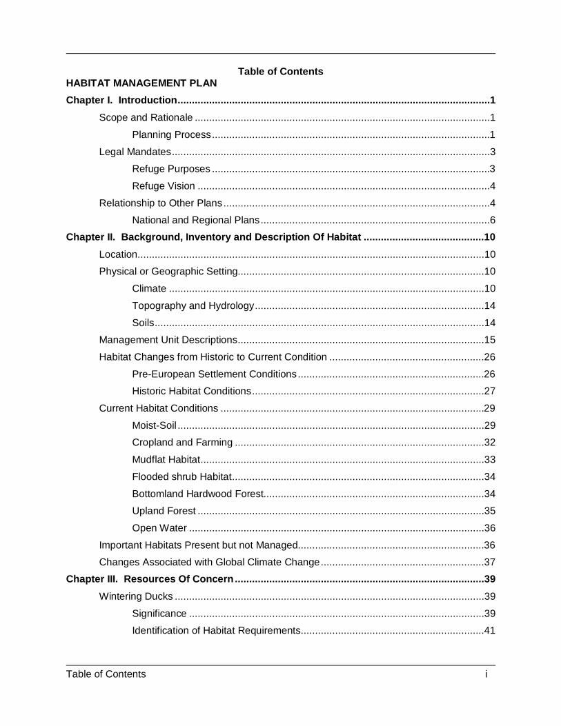
Table of Contents i
Table of Contents HABITAT MANAGEMENT PLAN Chapter I. Introduction .............................................................................................................1
Scope and Rationale .......................................................................................................1
Planning Process .................................................................................................1
Legal Mandates ...............................................................................................................3
Refuge Purposes .................................................................................................3
Refuge Vision ......................................................................................................4
Relationship to Other Plans .............................................................................................4
National and Regional Plans ................................................................................6
Chapter II. Background, Inventory and Description Of Habitat ..........................................10
Location .........................................................................................................................10
Physical or Geographic Setting......................................................................................10
Climate ..............................................................................................................10
Topography and Hydrology ................................................................................14
Soils ...................................................................................................................14
Management Unit Descriptions ......................................................................................15
Habitat Changes from Historic to Current Condition ......................................................26
Pre-European Settlement Conditions .................................................................26
Historic Habitat Conditions .................................................................................27
Current Habitat Conditions ............................................................................................29
Moist-Soil ...........................................................................................................29
Cropland and Farming .......................................................................................32
Mudflat Habitat ...................................................................................................33
Flooded shrub Habitat ........................................................................................34
Bottomland Hardwood Forest.............................................................................34
Upland Forest ....................................................................................................35
Open Water .......................................................................................................36
Important Habitats Present but not Managed.................................................................36
Changes Associated with Global Climate Change .........................................................37
Chapter III. Resources Of Concern .......................................................................................39
Wintering Ducks ............................................................................................................39
Significance .......................................................................................................39
Identification of Habitat Requirements ................................................................41

Table of Contents ii
Potential Refuge Contribution to Habitat Needs .................................................44
Black Ducks...................................................................................................................45
Significance .......................................................................................................45
Identification of Habitat Requirements ................................................................46
Potential Refuge Contribution to Habitat Needs .................................................49
Breeding Wood Ducks ...................................................................................................49
Significance .......................................................................................................49
Identification of Habitat Requirements ................................................................49
Potential Refuge Contribution to Habitat Needs .................................................50
Migrant geese (Southern James Bay, White-fronted geese) ..........................................51
Significance .......................................................................................................51
Identification of Habitat Requirements ................................................................53
Potential Refuge Contribution to Habitat Needs .................................................54
Shorebirds - Late Summer and Early Fall ......................................................................57
Significance .......................................................................................................57
Identification of Habitat Requirements ................................................................58
Potential Refuge Contribution to Habitat Needs .................................................59
Upland Mature Forest Landbirds ...................................................................................60
Significance .......................................................................................................60
Identification of Habitat Requirements ................................................................60
Potential Refuge Contribution to Habitat Needs .................................................61
Grassland/early successional Landbirds ........................................................................62
Significance .......................................................................................................62
Identification of Habitat Requirements ................................................................62
Potential Refuge Contribution to Habitat Needs .................................................63
Reconciling Conflicting Needs .......................................................................................63
Chapter IV. Habitat Goals and Objectives ............................................................................65
4.1. Habitat Management (CCP Goal 2) Goal: ...............................................................65
Objective 4.1.1. Moist-Soil Habitat Objective (CCP Objectives 2.1, 2.4, 2.6). ....65
Objective 4.1.2. Sanctuary (CCP Objective 1.3) .................................................66
Objective 4.1.3. Agriculture – Grain (CCP Objective(s): 1.1, 1.2, 2.3, 2.4)..........67
Objective 4.1.4. Agriculture – Green Browse (CCP Objective 2.3) .....................68
Objective 4.1.5. Fall Mudflat Habitat (CCP Objective 2.5) ..................................68
Objective 4.1.6. Flooded Shrub Habitat Objective (CCP Objective 2.5, 2.6). ......69

Table of Contents iii
Objective 4.1.7. Bottomland Hardwood Management (CCP Objective 2.2, 2.6) .70
Objective 4.1.8. Hardwood Forest Restoration (CCP Objective 2.2, 2.7) ............71
Objective 4.1.9. Oak savanna to Upland mesic forest - Continuum Management (CCP Objective 2.2, 2.6, 2.7, 2.8) ......................................................................72
Chapter V. Habitat Management Strategies ......................................................................75
Adaptive Management ...................................................................................................75
Moist-Soil Management Strategies ................................................................................75
Potential Strategies ............................................................................................75
Selected Management Strategies and Unit Prescriptions ...................................82
Waterfowl Sanctuary Management Strategies ...............................................................84
Potential Strategies ............................................................................................84
Selected Management Strategies and Unit Prescriptions ...................................85
Farming Management StrategIes ..................................................................................85
Potential Strategies ............................................................................................85
Selected Management Strategies and Unit Prescriptions ...................................89
Fall Mudflat Management Strategies .............................................................................90
Potential Strategies ............................................................................................90
Selected Management Strategies and Unit Prescription .....................................92
Shrub Wetlands Habitat Management Strategies ..........................................................93
Potential Strategies ............................................................................................93
Selected Management Strategies and Unit Prescriptions ...................................95
Bottomland Hardwood Habitat Management Strategies ................................................97
Potential Strategies ............................................................................................97
Selected Management Strategies and Unit Prescriptions ................................. 103
Oak Savanna to Upland Mesic Forest Continuum Management Strategies ................. 104
Potential Strategies .......................................................................................... 104
Selected Management Strategies and Unit Prescriptions ................................. 111
Appendix A. Forest Management Prescription ................................................................... 131
Appendix B. Cooperative Farming Agreement .................................................................. 150
Appendix C. Environmental Action Statement .................................................................. 153
Proposed Action and Alternatives. ............................................................................... 153
Categorical Exclusion(s). ............................................................................................. 156
Permits/Approvals. ...................................................................................................... 156
Public Involvement/Interagency Coordination. ............................................................. 157

Table of Contents iv
Supporting Documents. ............................................................................................... 157

Table of Contents v
LIST OF FIGURES Figure 1. Vicinity Map of Tennessee National Wildlife Refuge. ............................................2 Figure 2. Tennessee National Wildlife Refuge, Big Sandy Unit. .........................................11 Figure 3. Tennessee National Wildlife Refuge, Duck River Unit. ........................................12 Figure 4. Tennessee National Wildlife Refuge, Busseltown Unit. .......................................13 Figure 5. Habitat and management units on Tennessee NWR, Big Sandy Unit. ................17 Figure 6. Habitat and management units on Tennessee National Wildlife Refuge, Duck
River Unit. ....................................................................................................................20 Figure 7. Habitat and management units on Tennessee National Wildlife Refuge,
Busseltown Unit. .........................................................................................................24 Figure 8. The peak number of wintering ducks on Tennessee National Wildlife Refuge
from 1993-2013. ...........................................................................................................40 Figure 9. Mid-winter Survey Averages of American Black Duck on Tennessee National
Wildlife Refuge between 1970s and 2000s. ................................................................47 Figure 10. Peak Goose numbers on Tennessee National Wildlife Refuge between 1993-
2013. .............................................................................................................................53 Figure 11. Tennessee National Wildlife Refuge, Goose Management Zone 1....................55 Figure 12. Tennessee National Wildlife Refuge, Goose Management Zone 2....................56 LIST OF TABLES Table 1. Big Sandy Unit Summary Table, Tennessee NWR ................................................18 Table 2. Duck River Unit Summary Table, Tennessee NWR ...............................................21 Table 3. Busseltown Unit Summary Table, Tennessee NWR ..............................................25

1
CHAPTER I. INTRODUCTION SCOPE AND RATIONALE Throughout the century of its existence, the National Wildlife Refuge System has established a reputation as premier ground for the refinement of habitat management techniques. Ever since the establishment of Pelican Island National Wildlife Refuge in 1903, refuge employees have taken pride in developing the latest tools for wildlife conservation with limited resources. Some of the first examples of rocket nets and airboats, equipment now considered essential for wildlife management, were developed by refuge employees. The first prescribed fire on refuge lands was conducted in 1927 at a time when the benefits of this natural process were not well recognized and most federal agencies still considered fire to have “no place in any forest” (USFS 2004). As the discipline of wildlife management evolved, largely through the efforts of Aldo Leopold with his publication of Game Management in 1933, it was recognized that a greater emphasis needed to be placed on making decisions that are based on the best science of the day, while retaining some of the artful intuition that comes from years of field experience. Sound wildlife management will always involve the skillful integration of science and art in disciplines as diverse as biology and sociology. Habitat is defined as simply “the physical and biological surroundings of an organism” (Bolen and Robinson 1995). It includes all of the natural components of an ecosystem that are essential for survival including food, cover, and water. The processes that shaped features in central/west Tennessee, including Tennessee National Wildlife Refuge (NWR) (Figure 1), are complex and dynamic. This Habitat Management Plan (HMP) was developed to provide a clear, science-based outline for managing the refuge in this challenging environment. To this end, a HMP was developed as a first step in closing the gap between the needs of refuge wildlife and the knowledge of its stewards. PLANNING PROCESS HMPs are dynamic working documents that provide refuge managers a decision making process; guidance for the management of refuge habitat; and long-term vision, continuity, and consistency for habitat management on refuge lands. Each plan incorporates the role of refuge habitat in international, national, regional, tribal, State, ecosystem, and refuge goals and objectives; guides analysis and selection of specific habitat management strategies to achieve those habitat goals and objectives; and utilizes key data, scientific literature, expert opinion, and staff expertise. The statutory authority for conducting habitat management planning on National Wildlife Refuges is derived from the National Wildlife Refuge System Administration Act of 1966 (Refuge Administration Act), as amended by the National Wildlife Refuge Improvement Act of 1997 (Refuge Improvement Act), 16 U.S.C. 668dd - 668ee. Section 4(a)(3) of the Refuge Improvement Act states:

2
Figure 1. Vicinity Map of Tennessee National Wildlife Refuge.

3
“With respect to the System, it is the policy of the United States that each refuge shall be managed to fulfill the mission of the System, as well as the specific purposes for which that refuge was established …” and Section 4(a)(4) states: “In administering the System, the Secretary shall monitor the status and trends of fish, wildlife, and plants in each refuge.” The Refuge Improvement Act provides the Service the authority to establish policies, regulations, and guidelines governing habitat management planning within the System (Service Manual 620 FW 1). A HMP is a step-down management plan of the Refuge Comprehensive Conservation Plan (CCP). The CCP describes the desired future conditions of a refuge or planning unit and provides long-range guidance and management direction to achieve the purpose(s) of the refuge; helps fulfill the mission of the System; maintains and, where appropriate, restores the biological integrity, diversity, and environmental health of each refuge and the System; helps achieve the goals of the National Wilderness Preservation System, if appropriate; and meets other mandates. The CCP for Tennessee NWR was finalized in 2010 (USFWS 2010a). HMPs comply with all applicable laws, regulations, and policies governing the management of National Wildlife Refuge System. The lifespan of an HMP is 15 years and parallels that of refuge CCPs. HMPs are reviewed every 5 years utilizing peer review recommendations, as appropriate, in the HMP revision process or when initiating refuge CCPs. Annual Habitat Work Plans (AHWP) will contain management specifics and are prepared annually. LEGAL MANDATES REFUGE PURPOSES The purposes of a national wildlife refuge, as established by Congress or the Executive Branch, are the barometer by which all actions on that designated public land are measured. Habitat management, public use, and all other programs are required to fulfill the established purposes of the refuge. The establishing and acquisition authorities for Tennessee NWR include the Migratory Bird Conservation Act (16 U.S.C. 715-715r) and Fish and Wildlife Coordination Act (16 U.S.C. 661-667). These documents state that the refuge: “… [be] for use as an inviolate sanctuary, or for any other management purpose, for migratory birds.” “…shall be administered by him [Secretary of the Interior] directly or in accordance with cooperative agreements … and in accordance with such rules and regulations for the conservation, maintenance, and management of wildlife, resources thereof, and its habitat thereon …” In addition, Public Land Order 4560 identified the purposes of the refuge to be “… to build, operate and maintain sub-impoundment structures; produce food crops or cover for wildlife; to regulate and restrict hunting, trapping and fishing and to otherwise manage said lands and impoundment areas for the protection and production of wildlife and fish populations …” (Public Land Order, 1962).

4
Tennessee NWR was established to provide feeding and resting habitat for migratory birds in the central portion of the Mississippi Flyway, with an emphasis placed on providing habitat for wintering waterfowl. Objectives are achieved through a water management program for waterfowl, wading bird rookeries, and Neotropical migratory landbirds. Other methods are cultivation of about 3,150 acres of agricultural land and management of about 1,400 acres of moist-soil habitat. Management of the impoundments uses a network of levees and water control structures to adjust water levels to provide for the production of moist-soil and agricultural foods and the subsequent flooding of these habitats. The cooperative farming program leaves a portion of the crops grown to provide food for waterfowl and other wildlife (USFWS 2005). Refuge staff also plants some crops each year to ensure objectives are fully met. REFUGE VISION The Refuge vision was developed for the Comprehensive Conservation Plan for Tennessee NWR (USFWS 2010a): Tennessee National Wildlife Refuge was established in 1945 to provide an inviolate sanctuary and manage habitat for migratory birds. Over the foreseeable future, Tennessee NWR will continue its emphasis on managing habitat for waterfowl. The refuge will also expand its management activities for other migratory birds, in turn providing habitat for other wildlife. In addition, the refuge will strive to be a model for wise land stewardship, including management for indigenous species of flora and fauna and the control of invasive plants and animals. Tennessee NWR will also continue to serve the American people by expanding opportunities for appropriate and compatible, wildlife-dependent recreation such as hunting, fishing, wildlife photography and observation, as well as environmental education and interpretation. An adequate law enforcement presence will be provided in order to protect the public and natural and cultural resources. Refuge staff will build on existing partnerships with other agencies and stakeholders in implementing this vision. RELATIONSHIP TO OTHER PLANS The CCP outlines goals and objectives for refuge management over a 15-year period (USFWS 2010b). The Biological Review Report was instrumental in the development of the CCP (USFWS 2005). The purpose of the HMP is to provide more specific guidance that will facilitate the selection of prescriptions for implementing the goals and objectives of the CCP. In order to maintain consistent strategies for managing wildlife and habitats on the refuge, several other planning documents were used in the development of this Plan. Refuge endangered species with approved Recovery Plans include the following: The interior population of the least tern (Sterna antillarum athalossos) is federally listed as “Endangered” within all or portions of 18 states. The least tern nests on sparsely vegetated sand or gravel islands in wide river channels; however, only migrate by sites along the Tennessee River near the refuge. Although federally endangered Indiana bats (Myotis sodalis) and gray bats (Myotis grisescens) have not been found on the refuge, the potential for these species to periodically occur on the refuge is high. Featherfoot Cave, which housed about 11,228 bats in 2009 (TVA 2009), is

5
located about one mile south of the Busseltown Unit. The short term objective of the Indiana Bat Recovery Plan is to halt and reverse the continued decline of the species. The 1999 Revised Draft Recovery Plan identifies the following actions as being the most immediate needs: 1) Conduct research necessary for the survival and recovery of the Indiana bat; 2) Obtain information on population distribution, status and trends; 3) Protect and maintain Indiana bat populations; 4) Provide information and technical assistance outreach; and 5) Coordinate and implement the conservation and recovery of the Indiana bat (USFWS 1999). The ring pink (Obovaria retusa), orangefoot pimpleback (Plethobasus cooperianus), and pink mucket (Lampsilis orbiculata) mussels are listed as endangered and have been documented in the Tennessee River on the refuge. Rough pigtoe (Pleurobema plenum), fanshell (Cyprogenia stegaria), and white wartyback (Plethobasus cicatricosus) probably occurred within the boundaries of the refuge prior to the construction of Kentucky Dam and the establishment of the refuge. There are no records of the rough pigtoe in Kentucky Lake since it was inundated. A remnant fanshell population was reported below Pickwick Dam on Kentucky Lake. The last Tennessee record of the white wartyback occurred in 1987 below Pickwick Dam (Parmalee and Bogan 1998). The pygmy madtom (Noturus stanauli), a species of fish endemic to the Tennessee River drainage, is listed as endangered (USFWS 1994). Etnier and Starnes (1993) reported the pygmy madtom as one of the rarest fishes in North America with fewer than fifty individuals collected from two widely separated locations within the Tennessee River Valley. One location is on a short reach of the Clinch River in upper east Tennessee and the other near River Mile 17.5 on the Duck River in Humphreys County. The habitat requirements are described in the recovery plan as “shallow shoals, where the current is moderate to strong and where there is pea-sized gravel of fine sand substrates, in moderately large rivers” (USFWS 1994). The Bald and Golden Eagle Protection Act: Bald eagles (Haliaetus leucocephalus) were formally de-listed by the Service in July 2007 as a result of the widespread recovery of bald eagle populations in recent years; however, the refuge continues to monitor and protect nesting sites. Bald eagles are fairly common in the area; with upwards of 100 wintering on the refuge and around a dozen active nests scattered throughout the refuge. Golden eagles occasionally winter in very small numbers on the refuge. In addition to the legal and policy mandates, management on Tennessee NWR is influenced by other plans, those that are national or regional in scope, those that relate to activities of local entities, and those that relate to the refuge itself. Many of these plans are consistent with refuge goals and objectives, but, since different agencies have varying missions, it is inevitable that conflicts will arise. When this occurs, the refuge will recognize the differences of opinions and take measures to address the other agency’s concerns, where possible. However, the refuge would continue to manage with the mission, purposes, goals, and objectives of the refuge taking precedence.

6
NATIONAL AND REGIONAL PLANS Tennessee NWR lies within the focus area of a variety of regional or ecosystem-based conservation plans and cooperative initiatives. Tennessee Comprehensive Wildlife Conservation Strategy (TWRA 2005) Tennessee’s State Wildlife Grants (SWG) program began in fiscal year 2002. Under this new program, Congress provided an historic opportunity for state fish and wildlife agencies and their partners to design and implement a more comprehensive approach to the conservation of America’s wildlife. A requirement of SWG was that each state complete a Comprehensive Wildlife Conservation Strategy (CWCS) by October 1, 2005. Development of the CWCS was intended to identify and focus management on “species in greatest need of conservation.” Congress expects SWG funds to be used to manage and conserve declining species and avoid their potential listing under the Endangered Species Act. Tennessee’s CWCS effort began in 2003. In late 2003, the TWRA contracted with The Nature Conservancy (TNC) for the services of its state conservation planning manager to establish and lead a core planning team. The result of this team’s work, as well as the collaboration of Tennessee’s conservation partners, resulted in the production of the first edition of the Tennessee CWCS. The U.S. Fish and Wildlife Service approved the Tennessee CWCS in 2005. The CWCS uses a consolidated geographic information system (GIS) as a component for identifying wildlife species in the greatest need of conservation. The plan also describes the actions necessary for these species’ restoration (TWRA 2005). The state’s participation and contribution throughout the comprehensive conservation planning process provided for ongoing opportunities and open dialogue to improve the ecological health and diversity of fish and wildlife. A vital part of the comprehensive planning process was integrating common mission objectives where appropriate. North American Bird Conservation Initiative (NABCI 2005) The North American Bird Conservation Initiative aims to ensure that populations and habitats of North America's birds are protected, restored and enhanced through coordinated efforts at international, national, regional and local levels guided by sound science and effective management. It is designed to increase the effectiveness of existing and new initiatives through: effective coordination, building on existing regional partnerships, and fostering greater cooperation among the nations and the peoples of the continent. The U.S. North American Bird Conservation Initiative (NABCI) Committee is a forum of government agencies, private organizations, and bird initiatives helping partners across the continent meet their common bird conservation objectives. The Committee's strategy is to foster coordination and collaboration on key issues of concern, including coordinated bird monitoring, conservation design, private land conservation, international conservation, and institutional support in state and federal agencies for integrated bird conservation. Given the geographic location and predominance of upland hardwood forests, Tennessee NWR will contribute to the goals of the NABCI by participating in the Central Hardwoods Joint Venture and by contributing directly to bird conservation through the actions detailed in this plan. North American Waterfowl Management Plan (NAWMP 2004)

7
The North American Waterfowl Management Plan (NAWMP) was signed by the United States and Canadian governments in 1986 and undertook an intensive effort to protect and restore North America’s waterfowl populations and their habitats. With its update in 1994, Mexico became a signatory to the Plan. Restoration of wetlands and associated ecosystems is the main premise of the plan in order to restore waterfowl populations to levels observed in the 1970’s (NAWMP 2004). Joint Ventures, or “self-directed partnership[s] of agencies, organizations, corporations, tribes, or individuals that ha[ve] formally accepted the responsibility of implementing national or international bird conservation plans within a specific geographic area or for a specific taxonomic group, and ha[ve] received general acceptance in the bird conservation community for such responsibility” were formed under the auspices of the NAWMP to organize the efforts of interested partners and stakeholders in waterfowl conservation within specific regions, including the Lower Mississippi Valley. Tennessee NWR will contribute to the goals of the NAWMP by providing adequate habitats to meet the foraging needs of 121,000-182,000 ducks (or a range specified by NAWMP goals) for 110 days and other habitats that are needed for loafing, roosting, molting, etc. Tennessee NWR typically winters about 200,000 Mississippi Flyway ducks, with the peak over the past decade reaching more than 321,000. The refuge is an especially important wintering area for American black ducks (Anas rubripes). During normal winters, 20-30 percent of the entire Mississippi Flyway black duck population winters at the refuge. Other species found in significant numbers during fall and winter include the mallard (A. platyrhynchos), gadwall (A. strepera), wigeon (A. penelope), blue-winged teal (A. discors), green-winged teal (A. carolinensis), pintail (A. acuta), ring-necked duck (Aythya collaris), canvasback (A. valisineria), lesser scaup (A. affinis), bufflehead (Bucephala albeola), goldeneye (B. clangula), and ruddy duck (Oxyura jamaicensis). North American Waterbird Conservation Plan (Kushlan et, al 2002, Wires et. al 2010) The North American Waterbird Conservation Plan was developed under a partnership called the Waterbird Conservation for the Americas, which is a group of individuals and organizations having interest and responsibility for the conservation of waterbirds and their habitats in the Americas. The Tennessee NWR is located on the outskirts of the Upper Mississippi Valley/Great Lakes Waterbird Conservation Planning Area and supports breeding, wintering and migration habitat for the different waterbirds, such as king rail, egrets, and herons. United States Shorebird Conservation Plan (Brown et. al 2001) The United States Shorebird Conservation Plan is a partnership involving organizations throughout the United States committed to the conservation of shorebirds. Tennessee NWR is located within the Southeastern Coastal Plain Shorebird Conservation Region. On a regional scale, the refuge can help ensure that adequate quantity and quality of habitat is identified and maintained to support the different shorebirds that migrate through the area. Fisheries Vision for the Future (USFWS 2004) In 2001, the U.S. Fish and Wildlife Service worked with partners to refocus its Fisheries Program and develop a vision. This vision of the Service and its Fisheries Program “is working with partners to restore and maintain fish and other aquatic resources at self-sustaining levels

8
and to support Federal mitigation programs for the benefit of the American public.” To achieve the vision, the Fisheries program works with its partners to:
• Protect the health of aquatic habitats • Restore fish and other aquatic resources, and • Provide opportunities to enjoy the benefits of healthy aquatic resources.
Together, the group developed a series of goals, objectives, and implementation actions to focus on key needs. Tennessee NWR can contribute to the program’s recreational fishing goal to provide quality opportunities for responsible fishing and other related recreational enjoyment of aquatic resources on Service lands. Partners in Flight Bird Conservation Plan for the Interior Low Plateau [Physiographic Area 14] (Ford et al. 2000) This conservation plan addresses landbirds in the Interior Low Plateau physiographic area, which extends from north Alabama across central Tennessee and Kentucky into southern Illinois, Indiana, and Ohio. It consists of six distinct subregions: the Shawnee Hills, Bluegrass region, Western Highland Rim, Central Basin, Eastern Highland Rim, and Tennessee Valley. Its hilly topography sets it apart from the Coastal Plain to the south and Prairie Peninsula to the north. To the west, the valley of the Mississippi River separates the Interior Low Plateaus from the Ozark Highlands, the two of which share many similarities. Western mesophytic, oak-hickory, and beech-maple forests were historically the most abundant cover types. Kentucky/Barkley Lake Waterfowl Management Group A Kentucky/Barkley Lake Waterfowl Managers Group met and determined the waterfowl foraging needs for the Kentucky Lake Area (KLA). Kentucky Lake Waterfowl population objectives, distribution, habitat management objectives, and monitoring needs are outlined as objectives, strategies and actions in this HMP. To date the population objective and allocation of foraging habitat responsibilities by the involved land managers has been determined for ducks and geese. The population objective is as follows: Provide adequate foraging habitats in the Kentucky Lake Area to support a minimum of 206,022 ducks for 110 days and 28,069 Canada geese (Branta canadensis) for 90 days. Refer to Appendix 2 of this plan to see the process used to develop the duck and goose objectives. The allocation of duck habitat is as follows: Meet 50 percent of the foraging requirements on federal managed lands, 40 percent on state managed lands, 5 percent on private managed lands and 5 percent in natural habitats (Kentucky Lake, Big Sandy River, etc.). Goose habitat allocation is as follows: Meet 75 percent of the foraging requirements on federal managed lands, 10 percent on state managed lands, 5 percent on private managed lands and 10 percent in natural habitats (Kentucky Lake). The Northern Bobwhite Conservation Initiative: A Report on the Status of the Northern Bobwhite and a Plan for Recovery of the Species (Dimmick et al. 2002). This plan addresses the entire range of the species but provides step-down population and habitat objectives for individual Bird Conservation Regions, including BCR 24 (Central

9
Hardwoods) in which Tennessee NWR lies. The objectives are further broken down to the state level within individual BCRs. Central Hardwoods Joint Venture (Fitzgerald et al. 2003) The Central Hardwoods Joint Venture (CHJV) is a partnership of state and federal government agencies and non-governmental organizations who work together to ensure the long-term viability of native bird populations. Efforts of conservation are concentrated in the Central Hardwoods Bird Conservation Region (CHBCR), including the Ozark Highlands, Boston Mountains and Interior Lowland Plateaus. The area comprises 75 million acres of rolling hills covered primarily with hardwood forests interspersed with glades and woodlands and crisscrossed by deep river valleys including BCR 24 (Central Hardwoods) in which Tennessee NWR lies. The refuge is an identified area for priority wetland species, such as the American black duck. The refuge also plans to contribute to the woodland and savanna management CHJV objectives.

10
CHAPTER II. BACKGROUND, INVENTORY AND DESCRIPTION OF HABITAT LOCATION Tennessee National Wildlife Refuge runs along 65 miles of the Tennessee River (see Figure 1). The refuge is comprised of three units: the Duck River Unit (26,738 acres), Big Sandy Unit (21,348 acres), and Busseltown Unit (3,272 acres), for a total acreage of 51,358 acres. The Big Sandy Unit is the northernmost unit (Figure 2), located at the confluence of the Big Sandy and Tennessee Rivers, about 12 miles north of the town of Big Sandy. Most of the lands on this unit are upland and forested with little wetland management capabilities. Waterfowl management activities primarily consist of providing sanctuary on the waters and mudflats of Kentucky Lake and agricultural crops for foraging habitats. The Duck River Unit is located at the confluence of the Duck and Tennessee Rivers in Humphreys and Benton counties (Figure 3). This unit has the best wetland management potential of all units. A wide variety of habitats are available, including agriculture, moist-soil, mudflats, forested wetlands scrub-shrub, and upland forests. The Busseltown Unit is located along the western bank of the Tennessee River in Decatur County, roughly five miles northeast of Parsons, Tennessee (Figure 4). It is primarily managed for waterfowl by providing agricultural crops for foraging habitats. Some moist-soil and scrub-shrub habitats are also available. PHYSICAL OR GEOGRAPHIC SETTING CLIMATE The climate for the refuge region is described as having warm, humid summers and mild winters. However, summer temperatures in the 90s and winter lows well below freezing are not uncommon (Owenby and Ezell 1992). January is the coldest month, with an average temperature of 33.8 degrees Fahrenheit. July is normally the hottest, with an average temperature 77.7 degrees Fahrenheit. Winters are mild with most snow occurring in January and February (National Oceanographic and Atmospheric Administration/NOAA 2004). The average yearly rainfall is 53.7 inches, with the wettest season being spring. March is the wettest month with an average of 5.31 inches, and October is the driest at 3.35 inches on average (NOAA 2004). Yearly floods in bottomlands and along the shoreline of Kentucky Lake are common during winter and spring.

11
Figure 2. Tennessee National Wildlife Refuge, Big Sandy Unit.

12
Figure 3. Tennessee National Wildlife Refuge, Duck River Unit.
13
Figure 4. Tennessee National Wildlife Refuge, Busseltown Unit.

14
TOPOGRAPHY AND HYDROLOGY The majority of the refuge lands are located on the Western Highland Rim of the Interior Low Plateau Physiographic Province (Fenneman 1938; Thornburg 1965). Smalley (1980) describes the topography of the uplands of this region as "narrow winding to moderately broad undulating ridges flanked by steep side slopes" with narrow V-shaped valleys in the upper reaches of the intermittent streams, gradually becoming U-shaped and broader as the streams approach the major river bottoms. Land elevations range from approximately 640 to 354 feet above mean sea level (MSL). Over 5,000 acres of the refuge lie within the major river bottom floodplain of the Duck River. These lands are nearly flat to gently sloping, with well-drained to poorly-drained soils. A small portion of the Big Sandy Unit is within the East Gulf Coastal Plain Physiographic Province, where the topography is characterized as undulating and rolling with gentle to moderate slopes (Fenneman 1938). The remainder of the refuge acreage encompasses the hillsides surrounding the Tennessee River Valley, with a mixture of rolling hills and rocky high bluffs. Tennessee NWR lies within the Tennessee River Valley. In 1944, the construction of Kentucky Dam across the Tennessee River near Gilbertsville, Kentucky, was completed, forming Kentucky Lake. The excess waters of Kentucky Lake are discharged into the Tennessee River, which flows into the Ohio River. Drainage within much the bottomlands of the refuge is dependent upon the water level of Kentucky Lake. Under normal water flows, the TVA has sole control over the water management of Kentucky Lake for its primary objectives of flood control, navigation, and hydro power production. Lake levels are typically higher in the summer, reaching 359 feet MSL and lowered to a winter pool level of 354 feet MSL for floodwater storage. Uncontrolled flooding of the bottom lands on the refuge occurs when heavy rains fall within the Tennessee River Valley or when the Ohio and/or Mississippi rivers exceed flood stage, prompting the Corps of Engineers to order the TVA to reduce discharges from Kentucky Lake. Site-specific drainage varies considerably throughout the refuge. Drainage within the bottom lands ranges from good to poor depending on the soil type. Upland sites have well to excessive drainage, primarily related to topographic position. SOILS Most of the lands on Tennessee National Wildlife Refuge fall within four soil associations as described by Springer and Elder (1980). The soils of the upland sites within the Western Highland Rim are classified in the Bodine-Mountview-Dickson (D11) soil association. The western edge of the Big Sandy Unit, which is in the East Gulf Coastal Plain, is included in the Ruston-Lexington-Providence (C11) soil association. The hills just north of the Duck River Bottoms are classified in the Pickwick-Paden (C31) soil association. The Duck River Bottoms are included in the Wolftever-Egam-Beason-Lindside (A41) soil association. Springer and Elder (1980) describe the D11 soil association as consisting of “hilly and steep, excessively drained, cherty soils from limestone, and undulating, well-drained and moderately well-drained, silty soils from thin loess and limestone.” Most of the upland forests on the refuge are of this association. The soils of the hillsides are pale, deep, very cherty, droughty, strongly

15
acidic, and low in fertility. The cherty, well-drained to excessively drained Bodine soils cover the majority of the hills, especially on the steepest sites. Well-drained Mountview soils occur on the wider ridgetops. The soils of the narrow tracts of bottom land and foot slopes commonly are deep, well-drained, and strongly acidic, with variable amounts of chert washed from the nearby hills. These areas on the refuge are dominated by the moderately well-drained Paden soils and well-drained Humphreys soils of stream terraces. The C11 soil association is described by Springer and Elder (1980) as “undulating and rolling, brown, well-drained and moderately well-drained, silty soils from loess over coastal plain sediment; with bottoms of loamy and silty soils.” The only location on the refuge that this association occurs is on the Big Sandy Unit west of the Big Sandy River. These soils are generally well-drained, highly leached, low in natural fertility, and strongly acidic. The dominant soils that occur within the forested areas are the well-drained Dexter soils and moderately well-drained Freeland soils. The C31 soil association is characterized as ”undulating and rolling, well-drained, silty soils from thin loess and alluvium” (Springer and Elder 1980). The soils are generally deep, well-drained to moderately well-drained, low in fertility, and strongly acidic. This association is represented on the hillsides adjacent to the Duck River Bottoms. The moderately well-drained Paden soils dominate this area on the refuge. Springer and Elder (1980) describe the A41 soil association as “moderately well-drained and somewhat poorly drained, clayey and silty soils.” These soils are found on first bottoms and low terraces of the Tennessee River and are nearly level. They are deep, moderately well-drained to somewhat poorly drained, moderate in fertility, and moderately acidic. The moderately well-drained Wolftever soils occupy the low terraces or second bottoms. Silty, imperfectly drained, Lindside soils dominate the first bottoms. Well-drained loamy Huntington soils are near the river bank. The poorly drained Melvin soils are found in the sloughs. MANAGEMENT UNIT DESCRIPTIONS The Big Sandy Unit of Tennessee NWR has been separated into 26 HMP units which range in size from 69 to 2,900 acres (see Figure 5; Table 1). The Duck River Unit is divided into 38 HMP units which range in size from 60 to 2,800 acres (see Figure 6; Table 2). The Busseltown Unit has been separated into four HMP units (see Figure 7; Table 3). HMP unit boundaries are established along geographic features that can be easily identified on the ground (i.e. streams, roads, trails, etc). Tables 2-4 and Figures 5-7 provide existing land use by refuge units on Tennessee NWR. The acreages listed in each of the tables and habitats portrayed in the figures are estimates based on geospatially digitizing aerial photography, LiDAR (Duck River Unit), and topographic maps. The land use categories presented in these figures and tables are the general habitat types and/or land uses that occur on the refuge. The forested lands are divided into four broad categories; upland hardwoods, bottomland hardwoods, forest/shrub wetlands, and pine plantations. With the absence of a detailed forest inventory, assumptions were made in order to categorize the hardwood forest habitats. Topographic maps and, where available, LiDAR data were used to estimate the divisions between upland hardwoods from bottomland hardwoods from forested/shrub wetlands. Hardwood forests that are located outside the typical flood zone of Kentucky Lake, Duck River, or Cub Creek were classified as upland hardwoods. Forests located within the floodplain were designated as bottomland hardwoods and forest/shrub wetlands. Forest/shrub wetlands are

16
located on sites that are flooded annually under normal water management levels of the refuge impoundments or Kentucky Lake. Stands categorized as bottomland hardwoods are on sites that are only flooded during uncontrolled flood events. Pine plantations, which primarily consist of planted loblolly pine, were typically planted in upland sites on abandoned agricultural lands. The intensively managed open habitats on the refuge fall within the categories of moist-soil, agriculture, or a general classification of early successional. The early successional classification covers grass/forb dominated habitats that occur within sites wide range of land use purposes. Examples of lands classified as early successional are transmission line right-of-ways, levees planted in switchgrass, and buffer stripes between agriculture and other habitats, roads, or water bodies. The primary purpose of these lands is not to provide habitat but to support infrastructure or enhance wildlife access to another habitat. However, a secondary purpose is to coordinate management activities so that a quality grass/forb plant community provides habitat for a wide variety of wildlife. Non-woody wetland habitats consist of open water, emergent wetlands, and fall mudflats. Most of the open water is lacustrine habitat associated with Kentucky Lake and the larger managed impoundments. Emergent wetlands are typically very small and consist of cattail (Typha latifolia), lotus (Nelumbo lutea), and/or spatterdock (Nuphar lutea). The vast majority of the fall mudflats are produced by the fall drawdown of Kentucky Lake by TVA. A very limited amount of fall mudflat habitat is produced within the refuge impoundments. The facility classification represents all primary highways and refuge roads, buildings and associated grounds, parking lots, marinas, etc.

17
Figure 5. Habitat and management units on Tennessee NWR, Big Sandy Unit.

18
Table 1. Big Sandy Unit Summary Table, Tennessee NWR
HMP Unit Code
HMP Unit Name Survey Code
Upland Hard-
woods
*Pine Plantati
ons
Bottom-land Hard-
woods
**Forest/ Shrub
Wetland Moist-
soil Agriculture Grass
Dominated Plant
Community
Emergent Wetland
Open Water
Fall Mudflat Facility TOTAL Resource of
Concern Objective
BS1 Bennetts Creek Peninsula Forest Compartment
BCPFC 330 6 - - - - 23 - - - 5 364
MFL/GL 4.1.8/4.1.9
BS2 Mt. Zion Church Forest Compartment MZCFC 563 26 - - - 10 29 - 0 - 8 636 MFL/GL 4.1.8/4.1.9
BS3 Baker Cemetery Forest Compartment BCFC 525 9 - - - - - - - - - 534 MFL/GL 4.1.8/4.1.9
BS4 Pace Point Forest Compartment PPFC 557 1 - - - 19 2 - 6 - 7 593 MFL/GL 4.1.8/4.1.9
BS5 Robbins Creek North Forest Compartment RCNFC 591 20 - - - - 0 - - - 3 614 MFL/GL 4.1.8/4.1.9
BS6 Robbins Creek South Forest Compartment
RCSFC 514 13 - - - - 12 - 1 - 3 542
MFL/GL 4.1.8/4.1.9
BS7 Lashlee Springs Forest Compartment LSFC 374 - - - - - 18 - - - - 392 MFL/GL 4.1.9
BS8 Evans Cemetery Forest Compartment EVCFC 543 8 - - - - 19 - - - 4 574 MFL/GL 4.1.8/4.1.9
BS9 Liberty Cemetery Forest Compartment LBCFC 436 8 1 - - - - - - - 1 446 MFL/GL 4.1.8/4.1.9
BS10 New Hope Forest Compartment NHFC 352 - 31 1 - - - - - - 1 386 MFL 4.1.9
BS11 Britton Ford/Sulphur Well Island Forest Compartment
BFFC 625 - - - - - - - - - - 625
MFL/GL 4.1.9
BS12 Britton Ford - Sulphur Well Bay BFBA 105 - 47 19 - 367 46 - 796 57 27 1,465 WD/BD/MG/SB 4.1.2/4.1.3/4.1.4/
4.1.5
BS13 Swamp Creek SWCR 264 - 113 8 - 22 4 - 446 66 0 923 WD/MG/SB 4.1.2/4.1.4/4.1.5
BS14 Lashlee Springs Area LASH 60 - - 10 - 117 1 - 189 19 7 403 WD 4.1.3
BS15 Ross Creek Impoundment ROS 2 - - - 3 59 6 - - - 1 70 WD 4.1.1/4.1.2/4.1.3
BS16 Robbins Creek Impoundment ROB 1 - - - 4 58 9 - - - 2 74 WD 4.1.1/4.1.2/4.1.3
BS17 Bennetts Creek BEN 23 - - 4 4 71 12 - 1 - 0 115 WD 4.1.1/4.1.2/4.1.3

19
HMP Unit Code
HMP Unit Name Survey Code
Upland Hard-
woods
*Pine Plantati
ons
Bottom-land Hard-
woods
**Forest/ Shrub
Wetland Moist-
soil Agriculture Grass
Dominated Plant
Community
Emergent Wetland
Open Water
Fall Mudflat Facility TOTAL Resource of
Concern Objective
Impoundment
BS18 Tennessee River - East of Bennetts Creak Bay
BENCE - - - 9 - - - - 233 20 - 263
WD/SB 4.1.5
BS19 Bennetts Creek Bay Sanctuary BENCS - - - 24 - - 2 - 223 42 - 290 WD/MG/SB 4.1.2/4.1.5
BS20 Big Sandy Unit - Tennessee River BSTR - - - 3 - - - - 2,899 2 - 2,904 WD
BS21 Pace Point PACE 1 - - 10 - - - - 735 19 0 765 WD/SB 4.1.5
BS22 Big Sandy River - East BRE - - - 22 - - - - 2,808 25 - 2,855 WD/SB 4.1.5
BS23 Big Sandy River - Northwest BRNW 193 11 14 14 - - 4 - 2,353 20 2 2,610 WD/SB 4.1.5/4.1.8
BS24 Mansard Island Bay Area MANS 83 8 37 6 - - 2 - 105 16 7 263 WD/SB 4.1.5/4.1.8
BS25 Big Sandy River - Southwest BRSW 83 5 - 5 - - - - 1,872 4 2 1,971 WD 4.1.8
BS26 West Sandy Creek WSCR 78 16 5 9 - - - - 464 8 2 582 WD 4.1.8
TOTAL 6,300 132 249 144 11 724 189 - 13,130 297 82 21,257
ROC: Wintering ducks (WD); Black ducks (BD); Breeding wood ducks (BWD); Migrant geese (MG); Mature forest landbirds (MFL); Savanna landbirds (GL); and Shorebirds (SB). Objectives: 4.1.1 Moist soil; 4.1.2 Sanctuary; 4.1.3 Ag grain; 4.1.4 Ag goose browse; 4.1.5 Fall mudflats; 4.1.6 Flooded shrub; 4.1.7 Bottomland hardwoods;
4.1.8 Hardwood Restoration; 4.1.9 Savanna to forest continuum ** Forest/Shrub Wetlands consist of flooded shrub and

20
Figure 6. Habitat and management units on Tennessee National Wildlife Refuge, Duck River Unit.

21
Table 2. Duck River Unit Summary Table, Tennessee NWR
HMP Unit Code
HMP Unit Name Survey Code
Upland Hard-woods
Pine Wood-land
Bottom-land Hard-
woods
Forest/ Shrub
Wetland Moist-
soil Agriculture Early Successional
Emergent Wetland
Open Water
Fall Mudflat Facility TOTAL Resource of
Concern Objective
DR1 Duck River East Forest Compartment DREFC 617 - 33 2 - - - - - - 0 652 MFL 4.1.9
DR2 Nix Landing Forest Compartment NLFC 413 39 - - - - - - - - 14 466 MFL/GL 4.1.8/4.1.9
DR3 Opossum Creek Forest Compartment OCFC 555 8 31 - - - - - - - 2 597 MFL/GL 4.1.8/4.1.9
DR4 Pavatt Cemetery Forest Compartment PCFC 572 - - - - - - - - - 3 575 MFL/GL 4.1.9
DR5 Pigpen Hollow Forest Compartment PHFC 544 11 30 - - - - - - - - 585 MFL/GL 4.1.8/4.1.9
DR6 Roberts Creek Forest Compartment RCFC 459 13 122 6 - - - - - - 16 616 MFL/GL 4.1.8/4.1.9
DR7 Rabbit Hollow Forest Compartment RHFC 494 35 14 - - - - - - - - 543 MFL 4.1.8/4.1.9
DR8 Eagle Creek EAC 484 - 131 77 - - - - 375 95 3 1,164 MFL/GL/SB/BWD 4.1.5/4.1.6/4.1.9
DR9 Morgan Creek MOCR 469 14 290 120 - - - - 310 80 1 1,283 MFL/SB/BWD 4.1.5/4.1.6/4.1.8/4.1.9
DR10 Rockport Landing RPLD 592 - 66 98 - - - - 281 66 - 1,102 MFL/SB/BWD 4.1.5/4.1.6/4.1.9
DR11 Blue Creek BLCR 131 24 108 27 - - - - 225 44 50 610 WD/SB 4.1.5/4.1.8
DR12
Duck River Unit - Kentucky Lake - North DRKLN 4 - 9 78 - - - - 1,521 91 1 1,705 WD/SB 4.1.5
DR13
Duck River Unit - Tennessee River - East DRTRE - - 85 45 - - - - 835 112 - 1,076 WD/SB 4.1.5
DR14
Duck River Unit - Tennessee River - North DRTRN - - 7 26 - - - - 1,865 22 - 1,920 WD/SB 4.1.5
DR15
Duck River Unit - Tennessee River - South DRTRS - - 131 37 - - - 2 594 30 3 798 WD/SB 4.1.5

22
HMP Unit Code
HMP Unit Name Survey Code
Upland Hard-woods
Pine Wood-land
Bottom-land Hard-
woods
Forest/ Shrub
Wetland Moist-
soil Agriculture Early Successional
Emergent Wetland
Open Water
Fall Mudflat Facility TOTAL Resource of
Concern Objective
DR16
Duck River Unit - Tennessee River - West DRTRW - - 245 131 - - 2 - 1,084 118 16 1,595 WD/SB 4.1.5
DR17 Duck River DURV 40 - 541 303 - 114 12 - 1,384 463 2 2,859 WD/MG/BD/BWD/SB
4.1.2/4.1.3/4.1.4/4.1.5/4.1.6/4.1.7/4.1.8
DR18 Birdsong Creek BSC 181 - 100 110 - 98 1 22 262 96 3 873 BD/BWD/SB/WD 4.1.3/4.1.5/4.1.6
DR19 Dughill DUGH - - 67 26 - 65 1 - 24 25 - 207 WD/BD/BWD 4.1.3/4.1.6/4.1.7
DR20 Cooley Bottoms COOL 25 - 87 115 - 205 10 - 25 15 2 485 WD/BWD 4.1.3/4.1.6/4.1.7
DR21 Sycamore SYC 66 - 62 10 - 37 0 3 70 19 0 269 WD 4.1.3/4.1.8
DR22 Clear Lake on Kentucky Lake Side CLKYL - - 36 21 - 54 1 - 85 15 - 212 MG/WD 4.1.3/4.1.4
DR23 Honey Point Impoundment HOPT - - - - - 73 6 - - - 4 82 WD/BD 4.1.2/4.1.3
DR24 Pool 1 I01 100 - 19 170 563 21 6 - 294 - 25 1,198 WD/BD/BWD 4.1.1/4.1.2/4.1.3/4.1.6/4.1.7
DR25 Pool 2 I02 - - 5 86 218 91 15 - 193 - 9 619 WD/BD/MG 4.1.1/4.1.2/4.1.3/4.1.4/4.1.6/ 4.1.7
DR26 Pool 3 I03 - - 40 22 141 176 6 - 27 - 10 422 WD/MG 4.1.1/4.1.2/4.1.3/4.1.4/4.1.7
DR27 Pool 4 I04 - - 7 36 56 141 3 - 8 - 5 256 WD/MG 4.1.1/4.1.2/4.1.3/4.1.7
DR28 Pool 4A I04A - - 3 3 6 36 6 - - - 2 57 WD/MG 4.1.1/4.1.2/4.1.3/4.1.7
DR29 Pool 5 I05 23 - 8 6 58 35 4 - 6 - 4 145 WD/MG 4.1.1/4.1.2/4.1.3/4.1.7
DR30 Pool 6 I06 165 - 46 201 154 61 10 - 141 - 12 791 WD/BD/BWD/WG 4.1.1/4.1.2/4.1.3/4.1.4/4.1.6/ 4.1.7
DR31 Pool 7 I07 - - 32 119 223 51 24 20 85 - 6 561 WD/BD/BWD 4.1.1/4.1.2/4.1.3/4.1.6/4.1.7
DR32 Pool 8 I08 - - 0 4 3 179 6 - 0 - 5 197 WD/BD 4.1.2/4.1.3
DR33 Pool 9 I09 13 - 146 168 - 218 31 - 182 98 18 875 WD/BD/BWD/SB 4.1.2/4.1.3/4.1.5/4.1.6/4.1.7
DR34 Wood Duck Pond I09A 94 - 9 113 - 11 6 3 22 - 4 264 BD/BWD/WD 4.1.2/4.1.3/4.1.6/4.1.7

23
HMP Unit Code
HMP Unit Name Survey Code
Upland Hard-woods
Pine Wood-land
Bottom-land Hard-
woods
Forest/ Shrub
Wetland Moist-
soil Agriculture Early Successional
Emergent Wetland
Open Water
Fall Mudflat Facility TOTAL Resource of
Concern Objective
DR35 Pool 10 I10 - - 11 82 22 31 21 - 281 25 10 484 BWD/MG/SB/WD/BD 4.1.1/4.1.2/4.1.4/4.1.5/ 4.1.6/ 4.1.7
DR36 Pool 11 I11 16 - 9 13 23 7 8 - 21 - 4 101 WD 4.1.1/4.1.2/4.1.7
DR37 Pool 12 I12 32 - 0 23 - - 2 - 3 - 0 60 BD/BWD 4.1.2/4.1.6/4.1.7
DR38 Nix Landing Impoundment NXLD - - 127 47 - - - - 256 7 3 441 BWD 4.1.6/4.1.7
TOTAL 6,089 144 2,657 2,325 1,468 1,707 181 51 10,460 1,421 240 26,743
ROC: Wintering ducks (WD); Black ducks (BD); Breeding wood ducks (BWD); Migrant geese (MG); Mature forest landbirds (MFL); Savanna landbirds (GL); and Shorebirds (SB). Objectives: 4.1.1 Moist soil; 4.1.2 Sanctuary; 4.1.3 Ag grain; 4.1.4 Ag goose browse; 4.1.5 Fall mudflats; 4.1.6 Flooded shrub; 4.1.7 Bottomland hardwoods; 4.1.8 Hardwood Restoration; 4.1.9 Savanna to forest continuum

24
Figure 7. Habitat and management units on Tennessee National Wildlife Refuge, Busseltown Unit.

25
Table 3. Busseltown Unit Summary Table, Tennessee NWR
HMP Unit Code
HMP Unit Name
Survey Code
Upland Hardwoods
*Pine Plantation
Bottom-land
Hard-woods
Forest/ Shrub
Wetland Moist-
soil Agriculture Early Successional
Emergent Wetland
Open Water
Fall Mudflat Facility TOTAL Resource of
Concern Objective
BT1 Cub Creek CUBC 538 17 381 277 - - - - 434 18 - 1,663 BD/BWD/MFL 4.1.6/4.1.8
BT2 Busseltown Bottoms - North
BUSBN 69 - 81 17 6 206 6 - 150 2 3 539
WD/BD/BWD/MG 4.1.2/4.1.3/4.1.4/4.1.6
BT3 Busseltown Bottoms - Middle
BUSBM 6 - 36 56 0 336 5 8 154 3 11 616
WD/BD/BWD/MG 4.1.2/4.1.3/4.1.4/4.1.6
BT4 Busseltown Bottoms - South
BUSBS 81 - 37 41 0 151 1 - 130 2 2 444
WD/BD/BWD 4.1.2/4.1.3/4.1.6
TOTAL 693 17 534 390 7 693 12 8 868 24 16 3,262
ROC: Wintering ducks (WD); Black ducks (BD); Breeding wood ducks (BWD); Migrant geese (MG); Mature forest landbirds (MFL); Savanna landbirds (GL); and Shorebirds (SB). Objectives: 4.1.1 Moist soil; 4.1.2 Sanctuary; 4.1.3 Ag grain; 4.1.4 Ag goose browse; 4.1.5 Fall mudflats; 4.1.6 Flooded shrub; 4.1.7 Bottomland hardwoods; 4.1.8 Hardwood Restoration; 4.1.9 Savanna to forest continuum * Pine plantation consist of planted loblolly pine and areas that colonized beyond original plantation

Habitat Management Plan 26
HABITAT CHANGES FROM HISTORIC TO CURRENT CONDITION PRE-EUROPEAN SETTLEMENT CONDITIONS At the peak of the last major glacial period about 18,000 years ago, boreal vegetation extended to about 33º N. latitude, the approximate latitude of Birmingham, AL and Atlanta, GA (Delcourt and Delcourt 1993). The dominate trees were various spruce species (Picea spp.), jack pine (Pinus banksiana) and fir (Abies spp.) (Wright 1981). During glacial periods, extensive mesophytic forest communities, similar in character and overall composition to modern lowland and bottomland forests, occurred along major river drainages of the southeastern United States (Delcourt and Delcourt 1993). During the period of approximately 15,000-10,000 years ago there was a gradual warming trend, resulting in the replacement of the southern boreal forests with deciduous forests containing Oak (Quercus spp.), hickory (Carya spp.), chestnut (Castanea dentata) and other tree species common in the eastern deciduous forest. The mesophytic bottomland forests continued to persist in the major river drainages (Delcourt and Delcourt 1993). Many of the mega fauna (i.e., mastodon, ground sloth, and giant bison) became extinct between 12,000-10,000 years ago, likely altering regional vegetation (Martin and Klein 1984). Evidence of human habitation in the region becomes common at about 10,000 years ago (the Paleo-Indian period), but there is little evidence that these cultures had large-scale impacts on the landscape, due to low populations and their nomadic nature (Owen 2002). A significant warming and drying period began around 8,700 years ago to approximately 5,000 years ago impacting the vegetation of the Southeast. Prairies and savannas occurred throughout the region (Delcourt and Delcourt 1993), and xeric oak and oak-hickory forest types flourished. The population density of humans increased substantially during the transition from Paleo-Indian to Archaic Indian cultures. At about 4,000 years ago, the Archaic Indians began practicing agriculture throughout the region. This period also saw increasing emphasis on some forms of passive agriculture to increase the productivity of perennial plants. Intentional burning of vegetation was used to mimic the effects of natural fires that tended to clear forest understories, making travel easier and enhancing the growth of herbs and berry-producing plants that were important for both food and medicines (Owen 2002). Man began to establish relatively large settlements around 2,800 to 2,500 years ago during the transition from the Archaic Indian culture to the Woodland Indian culture. This culture moved toward more permanent settlements and to maintain local agricultural plots (Owen 2002). Woodland Indian Culture evolved into the Mississippian Indian Culture approximately 1,000 years ago (Owen 2002). Mississippian Culture agriculture became more highly developed (Delcourt 1987). Use of fire by native Americans to manage lands continued from approximately 4,000 years ago to approximately 500 or 600 years ago (Abrams 1992, Delcourt and Delcourt 1997). The occurrence of fire in the ecosystems of the United States was once a common event. Plant communities were developed and maintained by fires set by lightning strikes and later by Native Americans and then Anglo-Americans. Prior to the devastation of the Native American populations in the 16th and 17th centuries, as a result of European diseases, the Central Hardwoods Region was a managed landscape that largely consisted of open woodlands, savannas, and prairies (Van Lear 2004). Approximately 500 years ago, human populations declined significantly throughout the continent, resulting in large areas that had once been cleared, burned, and farmed left fallow (Owen 2002). Although European settlement in the

Habitat Management Plan 27
southeast began in the late 16th century, the impacts were limited to coastal areas and along the major rivers. Most of the upland forest in the interior Southeast remained essentially untouched by European settlement until the 19th century (Owen 2002). By the time the first European observers were reporting the type of the vegetation of the region, it had changed significantly from open woodlands, savannas, and prairies to closed canopy old growth forests. HISTORIC HABITAT CONDITIONS As the population of Euro-American settlers grew, additional natural resources in the form of timber and agricultural products increased. Settlement moved westward into the interior Southeast. They brought with them many species of non-native plants that have in several cases become extremely invasive. The settlers readily adapted the Indians use of fire to manipulate vegetation. Improved agricultural efficiency greatly increased the conversion of land for agriculture purposes. Wood products were needed to fuel the industrial revolution. In the mid-19th century clearcutting was the primary logging method utilized (Owen 2002). Prior to the establishment of the refuge in 1945, most of the forestlands had been used and altered settlers for well over a hundred years. Forests were cleared for farming, resulting in thousands of acres of agricultural lands. Some of the cleared land was marginal but farmed for years and then grazed. Much of this agricultural land was eventually abandoned, producing various stages of poorly stocked timber stands throughout the refuge. In the late 1800s, the iron ore industry clearcut forests in the region to produce charcoal. Where the topography was not conducive to clearing for agriculture, forest stands were heavily cut for sawtimber and then burned to encourage browse growth for livestock. It is likely that fire was frequently used to maintain open woodlands and savannas for grazing purposes. Historical fire regime varied across the landscape, primarily influenced by human activities, fuel availability and moisture conditions (Guyette and Dey 2004). This resulted in a wide range of habitat conditions, which enhanced flora and fauna richness. Locations with considerable topographic relief would have wide range of forest conditions created by a moisture continuum that ranges from mesic to xeric. Fire frequency and intensity would be greatest on xeric sites and diminish as the moisture continuum approaches mesic conditions. As a result, savanna and open oak woodlands would naturally occur on the more xeric sites. The low frequency and intensity of fire on the more mesic sites would favor closed oak woodlands and upland mesic forests. In the early 20th century forest management began to become a science in the United States, which promoted conservation of the nation’s forest resources. One unfortunate consequence of this movement was the widespread suppression of fire (Owen 2002). History has proven that without fire many of the natural plant communities that once dominated the landscape will quickly disappear. The oak dominated forest of the Central Hardwoods Region is dependent on fire to suppress shade intolerant species that impede oak regeneration and the future of oak dominance (Hartman 2005, Van Lear 2004). The grassy glades and savannas that survived the plow have now largely reverted to forest through natural succession due to the absence of fire (Hartman 2005, DeSelm 1994). Fire suppression is the primary factor leading to the degradation of woodlands and savannas (Nelson 2002). Another factor that has changed the forest characteristics of this region is the impacts of exotic disease-causing fungi and insects (Owen 2002). The most significant of these has been the

Habitat Management Plan 28
chestnut blight (Cryphonectria parasitica) that has essentially led to the ecological extinction of the American chestnut (Castanea dentata). The chestnut was once a dominant species in the Appalachian forests, including the area of the refuge. One of the most significant factors impacting historic habitat in the Tennessee River Valley, particularly west Tennessee, was the construction of Kentucky Dam on the Tennessee River between 1938 and 1944 which created Kentucky Lake. The terrain of the impoundment area was mostly flat and consisted of vast uncleared swamps and bottom lands, large fields of cultivated bottom lands, and large open lands denuded of topsoil, unproductive, and long ago abandoned. This latter condition of the terrain was most prevalent in the reservoir, especially in the lower portions. The Kentucky Dam project aided in flood control, attracted light industry to the area, improved navigation, provided hydroelectricity, and promoted tourist and recreational activities. River barge traffic increased and a number of port terminals and industrial parks were developed along the River. The 1962 Forest Management Plan for the Tennessee NWR had as its primary objective “to improve the forest condition so as to develop and maintain optimum game populations, primarily for wild turkey, white-tailed deer, and waterfowl, through sound forest management practices” (USFWS 1962). The secondary objective listed by this plan was “the application of good silvicultural practices aimed toward obtaining and maintaining optimum stocked timber stands of desired species, size classes and quality to best meet both wildlife requirements and commercial purposes.” In spite of the plan, little forest habitat management took place in the following decades. Some of the abandoned fields were planted in pine by the TVA in the 1940s and by the refuge in the 1970s, and a few were planted in oaks in the 1980s and 90s. A forest habitat management evaluation was conducted at Tennessee NWR in 1996 (USFWS 1996). In 1998, refuge staff began preparing a new Forest Management Plan (FMP) based on the findings of this evaluation. The evaluation recommended a refuge forest management program concentrating on the upland forested areas and their potential as habitat for a selected assemblage of migratory landbirds. The bird list of priority species was developed based on the Partners in Flight Bird Conservation Plan for the Interior Low Plateau (Ford et al. 2000). The refuge forest is similar to many of the forests in the region in that it is generally even-aged with near-completely closed canopies, small individual crowns and lacking midstory and understory vegetation/structure. The FMP sought to create more openings in the canopy, increased groundcover, understory and midstory presence, and larger, more developed canopy crowns. In 1999, with the aid of a new Refuge Forester, the refuge’s updated FMP was completed to final draft form and approved at the Service’s Southeast Regional Office in January 2000 (USFWS 2000). The refuge’s first forest inventory in nearly 40 years was conducted in the summer of 2000 as directed by the approved FMP. The cruise inventoried forest stand volumes and forest habitat conditions on 922 acres of the Big Sandy Peninsula identified as Compartment 4. The cruise data reinforced the conclusions of the 1996 forest habitat review. In nine of the ten delineated mature upland stands, the canopy closures were estimated to be ninety-three percent or more. These nine stands comprised over eighty percent of the mature forested area in Compartment 4 (USFWS unpub. data). A forest prescription plan was written and approved in 2001 for Compartment 4. The prescribed actions included timber harvesting and controlled burning. Prescribed fire was suggested in order to enhance the habitat by promoting grasses and forbs that attract invertebrates, which

Habitat Management Plan 29
are a critical component in the diet of many migratory landbirds. The primary target species of these management actions are the cerulean warbler (Setophaga cerulea), hooded warbler (S. citrina), wood thrush (Hylocichla mustelina), worm-eating warbler (Helmitheros vermivorum), Kentucky warbler (Geothlypis formosa). In addition to migratory landbirds, game species such as wild turkey (Meleagris gallopavo) and white-tailed deer (Odocoileus virginianus) will benefit from a more diverse forest structure. A study designed in conjunction with Dr. David Buehler of the University of Tennessee was established to test the results of a planned selective harvest and prescribed burn. The objectives of this research project were to evaluate the impacts of the refuge’s forest management activities on (1) habitat structure and composition; (2) breeding bird use; and (3) avian breeding productivity. Harvesting of the compartment began in 2001 and was conducted with a coordinated system of a track-mounted feller-buncher, followed by a track-mounted stroke de-limber, followed by either a traditional skidder or clam bunk. These machines allow precision directional felling and bunching which reduces the damage to the crowns and bark of remaining trees that is otherwise common in selective harvests. A prescription for the prescribed burn areas was developed and approved in 2002. Attempts were made on several occasions to conduct the burn. Due to weather conditions and problems associated with having a qualified burn crew available at the appropriate time when conditions were within prescription, the refuge was unsuccessful conducting this burn. With the loss of the forester position, no large-scale forest habitat management activities have been conducted since the harvest in 2001. CURRENT HABITAT CONDITIONS There is an annual average of 3,150 acres of cropland on all three units, with approximately 750 acres on the Big Sandy Unit, 1,700 on the Duck River Unit, and 700 acres on the Busseltown Unit. Most of this land is farmed each year through cooperative farming agreements to provide supplemental food and cover for the thousands of waterfowl. In addition, approximately 1,400 acres in the Duck River Bottoms are managed for moist-soil vegetation. These bottoms are compartmentalized by a series of levees with water control structures that allow water levels to be controlled for optimum waterfowl food production. The refuge contains approximately 20,000 acres of forest, with the majority being comprised of upland stands that are predominantly oak-hickory. Small isolated blocks of bottomland hardwoods occur on the Duck River and Busseltown units. See Figures 5-7. Most of these stands are dominated by light seeded species such as maples, sweetgum (Liquidambar styraciflua), and green ash (Fraxinus pennsylvanica). The remainder of the refuge not falling into the forested, agricultural, or moist-soil categories primarily consists of open water habitats (USFWS 2005). MOIST-SOIL Tennessee NWR manages moist-soil habitat to provide food and cover for a wide variety of waterfowl and other migratory birds. The refuge attempts to meet as much of the waterfowl forage objective through the moist-soil management program as feasible. Additionally, several other migratory bird groups, including rails, wading birds, shorebirds and some species of landbirds, benefit from the refuge’s moist-soil management practices. On occasion, management efforts within individual impoundments are focused towards species groups other than waterfowl.

Habitat Management Plan 30
The refuge’s moist-soil program essentially began in the mid-1980s when most of the impoundments were constructed. The moist-soil that exists today has largely resulted from the use of moist-soil management methods identified by Fredrickson and Taylor (1982). The refuge currently has the capability to manage for approximately 1,600 acres of moist-soil habitats (1,500 acres on the Duck River Unit and 50 acres each on the Big Sandy and Busseltown units). An average of 1,400 acres, with varying levels of quality, is produced each year. Capabilities of expanding the moist-soil program do exist, but additional impoundments will be needed and/or the farming program will be impacted. Moist-soil plants produce large quantities of seed and the value as waterfowl food have been known since at least the 1940’s (Low and Bellrose 1944). However, managing seasonally flooded herbaceous wetland impoundments or “moist-soil units” only became a widely accepted practice after many years of research in southeastern Missouri (Fredrickson and Taylor 1982, Fredrickson 1996). Good quality moist-soil habitat predominantly consists of annual grasses, sedges and broadleaf plants that produce a large amount of seed or tubers that are readily used as forage by waterfowl. Some of the most common moist-soil plants that are found on the refuge include wild millets (Echinochloa spp.), sprangletop (Leptochloa fusca), panicum (Panicum spp.), flatsedges (Cyperus spp.), yellow nutsedge (Cyperus esculentus), smartweeds (Polygonum spp.), toothcup (Ammannia coccinea), and beggarsticks (Bidens spp). Research has shown that high quality moist-soil can produce more than a 1,000 lbs/ac of seed (Fredrickson and Taylor 1982). Moist-soil impoundments are highly recommended as a means of diversifying habitat (Fredrickson and Taylor 1982, Reinecke et al. 1989) and supplying food with nutrients not generally available in agricultural grains. In addition to the foods available to waterfowl that are provided by moist-soil plants in the form of seeds, tubers, and other plant parts; aquatic invertebrate populations are diverse and abundant in moist-soil wetlands (Fredrickson and Taylor 1982, Reinecke et al. 1989, Gray et al. 1999). Invertebrates are typically much more abundant in natural habitats, such as moist-soil and flooded forests, and essentially nonexistent in most agricultural habitats (Fredrickson and Taylor 1982, Sherfy 1999). Fredrickson and Taylor (1982) suggested that the differences in the abundance of invertebrates between moist-soil and agricultural habitats is a reason why moist-soil habitats attract a greater diversity of waterfowl species than flooded cropland. Aquatic invertebrates are heavily utilized as a food resource by ducks throughout the annual life cycle. Invertebrates provide nutrients such as amino acids and micronutrients essential to survival and reproduction. Ducks extensively utilize invertebrates during high protein demand periods such as molt and egg laying (Fredrickson and Reid 1988). Food resources from moist-soil and agricultural plants are depleted or deteriorate as the winter period progresses, whereas the growth and development of invertebrates continues throughout the winter period, providing a more renewable food source (Sherfy 1999). The most significant issues the refuge staff faces with managing moist-soil habitats are (1) invasive native and non-native plants; (2) limited personnel time to properly manage all units; (3) impacts of growing season floods; and (4) deteriorating infrastructure (levees, spillways, and water control structures). Invasive and Nuisance Plant Species in Moist-Soil Habitat Some of the invasive plants known to occur in the wetland habitats on the refuge include alligatorweed (Alternanthera philoxeroides), parrot feather (Myriophyllum aquaticum), and purple loosestrife (Lythrum salicaria). Currently, only a few species are creating significant

Habitat Management Plan 31
problems on the refuge, but the potential exists for others to become major problems. Control of these species can be extremely difficult, and in many cases, will only be temporary due to the extremely invasive nature of these pests. Even if species are controlled on the refuge, they can easily be re-introduced from adjacent river system during flood events. The refuge staff have not conducted a complete inventory of all known invasive species and their locations within the refuge boundaries. Monitoring has been limited to the intensively managed wetland habitats. The invasive nature, adaptability to various soil moisture conditions, and resistance to mechanical and chemical control of alligatorweed have resulted in a significant impact on moist-soil management activities within the impoundments in Duck River Bottoms. Alligatorweed was first documented in the Duck River Bottoms in 1988 with a total of four acres found within four separate impoundments. It is now present in all of the impoundments on the refuge and without control it would likely dominate most moist-soil and shallow open water habitats. Several locations of heavy and light infestations occur on Kentucky Lake, both on and off the refuge (USFWS unpub. data). Most of the refuge’s invasive plant monitoring and control efforts are focused on alligatorweed within the impoundments on the refuge. Control efforts began in 1989 and continue to this date. Experiments have been conducted to evaluate mechanical (disking), water level management (keeping it as dry as possible), and herbicide (several different chemicals) treatments. Mechanical control efforts have been ruled out because disking spreads the plant, due to its ability to sprout from cuttings. Dry conditions do stress alligatorweed and allow competition from other plants, but will not eliminate it and the resulting habitat conditions are poor waterfowl habitat. Most locations where alligatorweed thrives cannot be dried sufficiently to have long-term effects. Frequent herbicide treatments appear to be the only means to gain any control over this plant. Of the herbicides tested, aquatic-labeled imazapyr products (i.e., Habitat) produce the best results (USFWS unpub. data). Applications of herbicide have been done using ground equipment (backpack sprayers, tractor and ATV-mounted boom sprayers) and aerially (helicopter). When possible, aerial treatments are the most feasible, due to access issues and the amount of area covered relative to the effort applied. Aerial treatments were initiated in 2002 when 320 acres of alligatorweed was sprayed with glyphosate. Aerial treatments of alligatorweed with glyphosate continued through 2005 with about 200 acres sprayed each year. Control of alligatorweed by glyphosate was limited and short-lived. In 2005 a new herbicide, Habitat (active ingredient imazapyr), was tested on 50 acres. Treatment results were promising and the acres treated more than doubled the next year. In addition to the aerial treatments, several acres are also sprayed using ground methods during each year. The results of this intensive effort seem to be reducing the density of alligatorweed but not eliminating the threat of reestablishment if control efforts are relaxed (USFWS unpub. data). Parrot feather, known to be extremely invasive in aquatic environments, was first located in 2002 on two acres within two impoundments in the Duck River Bottoms. Parrot feather was first treated with 2,4-D in 2003, which did not prove to be effective. Renovate (an aquatic labeled tryclopyr) was used in 2004 and control was not achieved. In 2005, Habitat herbicide was tested at a low rate and the results showed minimal control. The application rate for Habitat was increased to the maximum level in the 2007 treatments and control was much improved. Parrotfeather continues to appear sporadically in Pool 1, 2, and 3 in a clear downstream line for where it was first located in Pool 3. The refuge hopes to eliminate this plant before it becomes well established.

Habitat Management Plan 32
A small colony of purple loosestrife exists on the Busseltown Unit. This colony has been present there for a number of years with little indication of expansion. Herbicide treatment with glyphosate has been attempted for several years prior to 2003. This practice may have reduced the expansion of the colony but appeared to have no other long-term impacts. In 2003, approximately 2,500 Galerucella beetles were released in the purple loosestrife colony as a biological control agent. The beetles were then released during most years since the first release. This treatment appeared to be containing the colony, but due to repeated flooding not allowing the beetle colony to become well established coupled with a significant increase in the cost of beetles the releases were ended in 2010. A cypress and oak tree planting conducted a decade ago is becoming established providing some shading of the ditch, thus hindering purple loosestrife growth. Hopefully over time this area will be shaded out sufficiently to eliminate the purple loosestrife. Knot grass (Paspalum distichum)) and bigpod sesbania (Sesbania exaltata) are present in large patches within most of the moist-soil areas in the Duck River and Busseltown bottoms. They have currently reached unmanageable levels in the Duck River Bottoms impacting moist-soil production where they occur. The refuge has made significant effort towards controlling these plants, but with the focus on alligatorweed this effort has been limited. Paspalum is best controlled with Habitat, as glyphosate only provides temporary control. It typically fluctuates in abundance between wet and dry years. It is most prevalent during wet years and in wet holes and can decline significantly during dry years. Sesbania is best controlled through herbicide treatment with 2,4-D. Disking in late summer encourages new growth and mowing only provides temporary control. CROPLAND AND FARMING Agricultural crops play an important role in waterfowl management, as they provide a source of high-energy carbohydrates needed during periods of cold weather (Gates et al. 2001; Ely and Raveling 2011). Crops are also important when natural foods are unavailable. Loss of the wetland habitats that once supported the waterfowl populations in the Mississippi Flyway has resulted in a change in the availability of waterfowl food resources, because natural foods (e.g., acorns, moist-soil seeds, and invertebrates) became less abundant, while coverage of agricultural increased (Foster et al. 2010). Unharvested grain crops are now a critical ingredient of waterfowl foraging habitat needs, and if not available, the attractiveness of a refuge for waterfowl is decreased. Farming has been a significant component of the waterfowl management program since the refuge was established. Initially, nearly 9,000 acres of the refuge were farmed; however, in 1979 the farmed acreage was reduced to around 5,500 acres. During the early 1990s the farmed acreage reached an all-time low of approximately 1,700 acres in row crops. This acreage has since steadily increased to and stabilized at the current level of about 3,100 acres. The goal of the refuge’s farming program is to provide food and cover for migratory birds and other resident wildlife. It supplements natural foods with grains such as corn, milo, and millet, and winter wheat for green browse. Like many national wildlife refuges, Tennessee NWR has a cooperative farming program, under which five farmers have contracts with the refuge to cultivate crops, typically harvesting 75 percent for themselves and leaving 25 percent for wildlife on the refuge. Corn is the preferred crop for the refuge shares, although millet is planted in

Habitat Management Plan 33
areas that remain too wet for corn production. Annually, 3,000 to 3,500 acres have been farmed since the mid-1990s, including some acreage by force-account farming (planted by refuge staff). Force-account farming has included planting wheat and clover in harvested row crop fields and fallow fields for green browse, Japanese and brown-top millet in refurbished moist-soil areas, and occasionally corn and milo. The refuge requires the cooperative farmers to follow best management practices as they relate to crop rotations, conservation tillage, and pesticide use. The refuge implements integrated pest management strategies that addresses pesticide use requirements, as well as best management practices to reduce the amount of pesticides needed and measures to protect non-target plants and animals. In the past, many small fields, mainly in upland areas, have been farmed on the refuge in order to increase the acreage so additional refuge shares could be taken in fields utilized by waterfowl. Due to the small numbers of Canada geese now migrating to the refuge, utilization of some of the refuge share of corn has been minimal. Cooperative farmers express some concern regarding the large amounts of waste corn sprouting in the fields presenting “weed” problems the following year. They have also expressed a possible interest in abandoning unprofitable farmlands in some areas. Minor adjustments were made in the Duck River Bottoms that included planting some corn force-account and retiring poor and highly flood-prone farmland from the cooperative farming program. Some potential adjustments can be made on the Big Sandy Peninsula with increased force-account farming, but staff and funding limitations are an issue. Most of the remaining farmland is needed to meet objectives unless force-account farming is increased significantly beyond current capabilities. The cooperative farming program enables the refuge to better meet its objectives without much of the expense associated with force-account farming. Essentially, the only cost to the Service is administering the program. However, a price has to be paid in order to produce the agricultural foods at such a low cost. There is no doubt that if funds and/or personnel were not limited, the agricultural habitats on the refuge would be managed under a different program. Contract farming (private farmers contracted to plant all crops) or force-account farming (refuge staff planting all crops) would greatly reduce the acres under cultivation. Some positive results would be (1) more land available for other habitats; (2) less fragmentation of forested habitats; (3) reduction in the amount of pesticides and other agricultural inputs used on the refuge; (4) more control on when the crops are planted; (5) greater ability to follow best management practices; and (6) greater ability to plant more wildlife-desirable crop varieties (such as dwarf corn). A few problems exist with the croplands. First, healthy populations of turkey, resident Canada geese, and deer eat the crops leaving less for the migratory birds. In addition, the amount of crops eaten during the growing season threatens the profitability of the cooperative farming. The proliferation of private hunting clubs near the refuge boundary limit the area where crops can be left for waterfowl by the cooperative farming program because of the necessary barrier needed to provide a sanctuary and the legal aspects of the refuge manipulating crops during the waterfowl hunting season. Flooding of the crops is much more desirable but is costly and cannot be achieved in all areas of the refuge. By damaging the levees and damming ditches, beavers and invasive species are obstacles to maintenance of this habitat type (USFWS 2005). MUDFLAT HABITAT
Habitat Management Plan 34
In addition to the managed habitats addressed above, there are several habitats produced by TVAs reservoir operation that are extremely important to many species of wetland wildlife. The primary role the refuge plays with these habitats is informing partners about the importance of maintaining certain pool levels to produce desired habitat conditions. Most of these habitats are outside the main levees of Duck River and Busseltown Dewatering Areas and are influenced by the TVA’s Kentucky Lake operation schedule. Under the current reservoir operation schedule, the drawdown of Kentucky Lake from summer pool (359 feet MSL) toward winter pool starts around July 5 and steadily drops to winter pool (354 feet MSL) by December 1. By mid- to late August, the level typically drops approximately two feet. At this level water is completely off the willow-buttonbush zone, allowing woody plants and herbaceous perennials an opportunity to “breathe” and seedlings to germinate. Annual plants such as tealgrass (Eragrostis hypnoides) and yellow nutsedge germinate in areas where the sunlight is sufficient. Shorebirds and early migrating blue-winged teal readily utilize the newly exposed mudflats that are free of dense woody vegetation (Wirwa 2009). The water level continues to drop throughout the fall, exposing vast areas of mudflats. Normally, during the fall the only habitat available to shorebirds on the refuge are the flats associated with Kentucky Lake. Annual grasses and sedges carpet these flats providing browse for geese and some species of ducks. This habitat is critical for early migrating geese that start arriving in late September because it is typically the only habitat available at this time of the year, because crop harvest has not yet been initiated. Throughout the fall and winter, tens of thousands of green-winged teal, wigeon, and gadwall forage on these flats (Wirwa 2009). FLOODED SHRUB HABITAT Flooded shrub habitat on the refuge is primarily limited to linear bands and isolated blocks in low-lying areas along the shore of Kentucky Lake, primarily along the Duck River and Cub Creek. Flooded shrub habitat also occurs within the Duck River and Busseltown Units impounded areas. Many of these stands have resulted from the natural succession of abandoned agricultural areas. The woody species composition consists mostly of black willow, buttonbush (Cephalanthus occidentalis), swamp privet (Forestiera acuminata), and water elm (Planera aquatica). The flooded shrub habitat on the refuge serve as important brood-rearing habitat for wood ducks as well as supporting several species of nesting landbirds, such as the prothonotary warbler and Acadian flycatcher. During the fall and winter several waterfowl species, primarily mallards, black ducks, and wood ducks, readily utilize flooded woodlands and shrub habitat for cover, foraging, and pair-bonding activities. The decaying leaves in flooded woods attract high concentrations of aquatic invertebrates, which are a very important source of protein for waterfowl. The willow-buttonbush zone along the shoreline of Kentucky Lake that is flooded during the spring and early summer not only provides excellent wood duck brood habitat, but also supports many other species of birds, reptiles, amphibians, and mammals. This habitat is also essential for spawning and fry survival for many species of fish. BOTTOMLAND HARDWOOD FOREST

Habitat Management Plan 35
Bottomland hardwood forests on the refuge primarily occur within the bottomlands adjacent to the Duck River and within the larger creek bottoms entering Kentucky Lake. Most of the tracts are small and widely scattered. It is estimated that around 3,200 acres are present on the Duck River and Busseltown units. This habitat is essentially absent from the Big Sandy Unit. A forest inventory is needed to better quantify the presence of bottomland hardwood habitat. Much of the lands that are now classified as bottomland hardwoods are a result of abandoned agricultural lands naturally reverting to forest. As a result the the dominant tree species are pioneer species such as, sweetgum, silver maple, and green ash. Very few stands contain a good composition of hard mast-producing trees. Only a few areas that were abandoned have been planted to oaks. Within some remote areas of the refuge, beaver activities have resulted in the loss of quality bottomland hardwoods. The following type descriptions are taken from “Forest Cover Types of the United States and Canada,” (Eyre 1980) and represent the major bottomland hardwood forest types found on the refuge: Type 62 - Silver Maple-American Elm; Type 92 - Swamp Chestnut Oak-Cherrybark Oak; and Type 94 - Sycamore-Sweetgum-American Elm. UPLAND FOREST Heavy clearcutting within the late 1800s to early 1900s within the region and on the refuge has resulted in the current forest conditions. Much of the refuge’s forest stands are generally even-aged with closed canopies and a sparse midstory and understory as a result of these practices. Most of the upland hardwood forest stands on the refuge are in a stagnant stage due to a fully stocked overstory. Canopy closure typically approaches 100 percent, resulting in less than desirable vertical structure. This overstocked condition has reduced growth and crown development in the overstory, suppressed midstory and understory development, and restricted the growth of desirable regeneration needed to perpetuate the forest. Larger crowns and boles (at least 25" diameter at breast height, or DBH) in the overstory and a well-developed midstory and understory are needed to best meet the habitat requirements of the priority neotropical migratory birds. There have not been any large-scale forest habitat management activities since the harvest in Compartment 4 of the Big Sandy Unit in 2001. Several attempts were made at using prescribed burns on the refuge, but it proved logistically difficult to coordinate weather conditions with the fire teams’ availability. Harvest of Compartment 4 was conducted in a manner that would be conducive to conducting research that would determine the impacts of the forest management activities. All harvest activities were suspended until the results of the research project were available. The research was completed and the results demonstrated that the management activity had positive effects on several PIF priority landbird species (Thatcher 2007). The most significant issues the refuge staff faces with managing forested habitats are (1) lack of funding; (2) lack of available forester; and (3) availability of fire crew. The following type descriptions are taken from “Forest Cover Types of the United States and Canada,” (Eyre 1980) and represent the major upland forest types found on the refuge: Type 40; Post Oak-Blackjack Oak; Type 44; Chestnut Oak; Type 52; White Oak-Black Oak-Northern Red Oak; Type 53; White Oak; Type 81 - Loblolly Pine;

Habitat Management Plan 36
Various species of pest plants exist in the refuge’s forested areas. Chinese privet (Ligustrum spp.), Japanese stiltgrass (Microstegium vimineusm), Japanese honeysuckle (Lonicera japonica), kudzu (Pueraria montana), mimosa (Albizia julibrissin), tree of heaven (Ailanthus altissima), and multifloral rose (Rosa multiflora), are species of concern. At this time, these invasive species are not greatly impacting the management objectives of the refuge. The refuge is monitoring some areas with kudzu and privet. Forest management actions on Big Sandy plots will be monitored for an increase invasive species. The refuge is continuing to look for potential partners to help with this activity. The Friends of Tennessee NWR have been active in the support of invasive species control through working to control Chinese privet and supporting school group education of this important issue. OPEN WATER Open water in this document is defined as permanent lacustrine water bodies that occur on Kentucky Lake and within the refuge constructed impoundments. This habitat is void of vegetation with the potential exception of submerged aquatic plants. Water depth varies from being very shallow at mudflat shorelines to approximately 50 feet in the inundated Tennessee River channel. Some riverine open water habitats occur on the refuge on the upper reaches of the Duck River Unit and the streams that flow into the lake and impoundments. The amount of open water varies within the year depending on water level. This could also vary among years depending on habitat management stratigies. The habitat maps and acres in the tables illustrate the typical lowest water level within each management unit. For most of the managed impoundments, the low water level is the elevation of the bottom of the outlet water control structure. Some impoundments are not normally drained to the lowest level possible for fisheries purposes, so the open water habitat in those impoundments is based on the typical water management level. The open water on Kentucky Lake is based on the typical winter pool level of 355.0 feet MSL. TVA manages the levels of Kentucky Lake based on an operation schedule that is designed primarily to reduce flood risk downstream of Kentucky Dam. This schedule calls for a summer (May-June) pool level of 359.0 feet MSL and a winter (December-March) pool level of 354.0 feet MSL. Kentucky Dam created one of the largest manmade lakes in the United States. Kentucky Lake covers approximately one-half of the refuge, as a result of the inundation of the Tennessee, Duck and Big Sandy Rivers. The larger refuge managed impoundments also have a significant open water component. The open waters of the refuge attract large numbers of diving ducks and mergansers that feed on mollusks and fish. Puddle ducks also commonly are attracted to this habitat to feed on invertebrates and as loafing areas. Submerged aquatic vegetation beds on the lake at the Duck River Unit attract very large numbers or ducks during the early fall. Common loons (Gavia immer), grebes, gulls, terns, white pelicans (Pelecanus erythrorhynchos), double-crested cormorants (Phalacrocorax auritus), and coots (Fulica americana) are seasonally abundant within the open water habitats. As many as 700 common loons and 500 horned grebes (Podiceps auritus) have been observed by birders during the fall on the Big Sandy River embayment of the refuge. Gulls and terns are abundant throughout Kentucky Lake. IMPORTANT HABITATS PRESENT BUT NOT MANAGED

Habitat Management Plan 37
Habitats associated with Kentucky Lake Reservoir During the winter and early spring flood events, many of the mallards, black ducks, and wood ducks will vacate the managed habitats in the bottoms to utilize the newly flooded moist-soil, willow-buttonbush, and bottomland hardwood habitats along the shoreline of the reservoir (Wirwa 2009). Over 55 percent of the duck use and 48 percent of the goose use on the refuge is found to occur in the reservoir as opposed to the more intensively managed impoundments (USFWS unpub. data). The water schedule reverses on April 1 and the reservoir is allowed to quickly rise to summer pool by May 1. The willow-buttonbush zone is again flooded, providing excellent wood duck brood habitat, as well as habitat for many other species of birds, reptiles, amphibians, and mammals. This habitat is also essential for spawning and fry survival for many species of fish. Submersed and free-floating aquatic plant communities are found in scattered locations within the impoundments and on the reservoir throughout the refuge where conditions are favorable. These plant communities consist of both native and invasive species, including hydrilla (Hydrilla verticillata), Eurasian watermilfoil (Myriophyllum spicatum), spinyleaf naiad (Najas minor), southern naiad (N. guadalupensis), coontail (Ceratophyllum demersum), and duckweeds (Lemna spp.). Waterfowl commonly utilize these habitats especially during the early fall. The refuge does not specifically manage the aquatic plant species listed above. Diving ducks and mergansers utilize the open deep water habitats that primarily occur on Kentucky Lake. The Big Sandy Unit holds a greater number and diversity of these species than the other two units combined. Diving ducks and mergansers make up approximately 20 percent of the ducks on this unit (USFWS unpub. data). The only management the refuge practices in these habitats is protection from disturbance and unintentional take with commercial fishing nets. During the early 1990's the refuge documented a problem with diving ducks getting entangled in commercial fishing gear within high use areas of the Big Sandy Unit. The refuge staff worked with the TWRA to change commercial fishing regulations for the refuge during the wintering period. Since the new regulations have been in place, no further kills have been documented on the refuge. The refuge has also closed some of the highest use areas to boats to reduce disturbance. CHANGES ASSOCIATED WITH GLOBAL CLIMATE CHANGE The Intergovernmental Panel on Climate Change (IPCC) has concluded that "warming of the climate system is unequivocal (Metz et al. 2005)." Global climate change poses risks not only to human health but also to terrestrial and aquatic ecosystems. The abundance and distribution of wildlife and fish will change, particularly affecting those species already "at risk." Important economic resources such as agriculture, forestry, and water resources also can be affected. Warmer temperatures, more severe droughts and floods, and sea level rise will have a wide range of impacts. All these stresses, added to existing stresses on resources caused by other influences such as population growth, land-use changes, and pollution, pose a significant challenge for fish and wildlife conservation. According to NOAA and NASA data, the Earth's average surface temperature has increased by about 1.2 to 1.4ºF since 1900. Some climate models, based on emissions of greenhouse gases, primarily carbon dioxide, methane, and nitrous oxide, predict that average surface

Habitat Management Plan 38
temperatures could increase from 2.5 to 10.4ºF by the end of the 21st century. The frequency of extremely hot summer days is expected to increase, along with this general warming trend. Increases in atmospheric CO2 are attributed largely to human activities, which have grown rapidly since the 1940's. The burning of fossil fuels adds 5.6 billion tons of carbon, (and deforestation contributes another 0.4 to 2.5 billion tons of carbon) to the atmosphere each year. The effects of climate change and global warming will be changes in weather/rainfall patterns, decreases in snow and ice cover, rising sea levels, and stressed ecosystems. For the Southeastern U.S. and the Tennessee region this could mean extreme precipitation events; greater likelihood of warmer/dryer summers and wetter/reduced winter cold; and, alterations of ecosystems and habitats due to these changes in weather patterns. For Tennessee NWR, warmer conditions would favor increased densities of vegetation and wetter conditions would favor trees and vegetation that are better adapted to these conditions. If conditions become drier, the current range and density of forests would be reduced and replaced by grasslands and the probability of wildfires would increase. A recent study of the effects of climate change on Eastern U.S. bird species concluded that as many as 78 bird species could decrease by at least 25 percent while as many as 33 species could increase in abundance by at least 25 percent due to climate and habitat changes (Matthews et al. 2004). In short, global warming could increase storm intensity, negatively change ecologically important plant species, alter the spread of invasive species, increase drought-induced fires, and further imperil already threatened and endangered species.
Habitat Management Plan 39
CHAPTER III. RESOURCES OF CONCERN Priorities associated with wildlife and habitat management for the NWRS are determined through directives, policies, and legal mandates. Resources of concern include species, species groups, and/or communities that support refuge purposes as well as FWS trust resource responsibilities (including threatened and endangered species and migratory birds). Resources of concern are also native species and natural, functional communities such as those found under historic conditions that are to be maintained and, where appropriate, restored on a refuge (601 FW 3.10B[1]). Resources of concern for Tennessee NWR were selected after taking into account the conservation needs identified within international, national, regional, or ecosystem goals/plans; state fish and wildlife conservation plans; recovery plans for threatened and endangered species; and previously approved refuge resource management plans as identified in the Comprehensive Conservation Planning Process policy [602 FW 3.4 C[1][e]) as well as Chapter I of this HMP. The species/communities selected as resources of concern from these plans support the following NWRS mandates:
• Support refuge purposes and the NWRS mission; • Conserve biological integrity, diversity, and environmental health (giving special
consideration to rare, declining or unique natural communities, species, and ecological processes within the refuge boundary); and
• Fulfill FWS trust resource responsibilities (see Chapter I) Resources of concern identified for Tennessee NWR include:
• Wintering Ducks • Black Ducks • Breeding Wood Ducks • Migrant geese (including Southern James Bay Canada geese and White-fronted geese) • Upland Mature Forest Landbirds (Cerulean warbler, worm-eating warbler, wood thrush,
Kentucky warbler, Louisiana waterthrush) • Grassland/Early Successional Landbirds (Northern bobwhite, blue-winged warbler,
prairie warbler, Henslow’s sparrow) • Shorebirds - late summer and early fall
WINTERING DUCKS SIGNIFICANCE Tennessee NWR serves as an important migration stopover and wintering grounds for thousands of migratory waterfowl using the Mississippi Flyway. The refuge has averaged approximately 200,000 ducks during the past five winters. In some cold winters, the refuge has been known to exceed a peak of 250,000 ducks. During the last fifteen years, ducks have peaked at 320,000 (Figure 8) (USFWS unpub. data). With the diversity of habitats available to waterfowl on the refuge, all species that utilize the mid-continent portion of the Mississippi Flyway occur on the refuge. Mallard numbers account for around two-thirds of the total wintering duck population on Tennessee NWR, with a winter peak averaging 136,000 over the last 5 years. Other duck species present in significant numbers during spring and fall migration

Habitat Management Plan 40
and/or winter include gadwall, widgeon, green-winged teal, pintail, black duck, wood duck, blue-winged teal, shoveler, ring-necked duck, canvasback, lesser scaup, bufflehead, goldeneye, ruddy duck, and hooded merganser. Tennessee NWR is part of the larger seven-county Kentucky Lake Area (KLA), one of the state’s top three waterfowl sites. Numerous state WMAs and private land waterfowl impoundments are within this seven-county landscape, all with the potential to provide duck foraging and sanctuary requirements. A biological review conducted in 2004 (USFWS 2005) recommended the refuge should provide 60 percent of the KLA foraging needs for 202,000 ducks for 110 days (22.2 million duck-energy days [DEDs]). This would result in refuge foraging habitat objectives of 121,000 ducks for 110 days. The duck population objective was derived from the 1970-79 average KLA Midwinter Inventory for nine species of ducks, plus a separate wood duck objective added to create the total. Under this objective, the foraging needs of the remaining 40 percent of the duck population will be provided on state WMAs, TVA properties, and private lands. Figure 8. The peak number of wintering ducks on Tennessee National Wildlife Refuge
from 1993-2013.
Habitat Management Plan 41
IDENTIFICATION OF HABITAT REQUIREMENTS North American waterfowl have seasonally dynamic life-cycle needs that are fulfilled by use of a diversity of habitats and foods throughout their annual range, which, for most species, is continental in scale in contrast to resident wildlife. Indeed, habitat (both its quantity and quality) is the primary template for ecological strategies of waterfowl (and all wildlife) and a critical determinant of their survival and productivity. Hence, sustaining viable and harvestable populations of waterfowl depends on conservation and management of habitats throughout the Flyways of North America. Concerning migration and wintering habitat, dabbling ducks need a diversity of wetlands including the following: (1) flooded cropland, (2) natural wetlands, and (3) refuge (i.e., sanctuary) (Reinecke et al. 1989). Two natural wetland habitats that ducks have used historically in the Mississippi Flyway are bottomland hardwood forests and moist-soil habitats (i.e., early successional grass-sedge and other herbaceous vegetated wetlands). These natural wetlands are critical foraging and resting habitats. Both hardwood bottomlands and moist-soil habitats are rich in high-energy natural seeds (e.g., acorns in oak bottomlands; grass-sedge seeds, roots, tubers, etc. in moist-soil areas) and aquatic invertebrates (Kaminski et al. 2003, Heitmeyer 1988, 2006). Indeed, wintering waterfowl satisfied their nutritional and other physiological needs in these wetlands before large-scale conversion of the bottomland hardwood forest to agriculture. Bottomland Hardwood Forest Fredrickson and Batema (1992) identified “low hardwood wetlands” as extremely productive ecosystems with a diversity of habitats that are important as breeding and wintering areas for eight species of waterfowl. The dynamic hydrology with varying flooding regimes is a major driving force that makes these ecosystems diverse and productive. The nutrient pulses that are a result of floodwaters enhances the productivity of these wetlands, which in turn increase biomass in the form of waterfowl foods such as macroinvertebrates, moist-soil plant seeds, aquatic macrophytes, and soft and hard mast from hardwood trees. Several species of waterfowl heavily utilize flooded forested habitat in winter for resting and foraging for acorns, other fruits, various seeds, and invertebrates. Wood ducks seek these habitats almost exclusive of other habitats (Dugger and Fredrickson 2001). Breeding wood ducks and hooded mergansers nest in tree cavities that are in or near forested wetlands where they raise their broods. Mallards, gadwall, and wigeon all utilize flooded forested habitat as one of the complex of preferred habitats (Fredrickson and Heitmeyer 1988). These areas are vital to waterfowl for pair bonding, loafing, sanctuary, thermal cover and feeding (Reinecke et al. 1989). Moist-Soil Habitat The high seed production of moist-soil plants and their value as waterfowl foods have been known since at least the 1940s (Low and Bellrose 1944). However, managing seasonally flooded herbaceous wetland impoundments or “moist-soil units” only became a widely accepted practice after many years of research in southeastern Missouri (Fredrickson and Taylor 1982, Fredrickson 1996). Although geese sometimes use moist-soil impoundments and eat shoots of germinating plants, rhizomes, roots, or tubers (Austin et al., 1998), the primary emphasis of moist-soil management is to produce seeds that will provide food for ducks. Most research has focused on estimating

Habitat Management Plan 42
seed production and studies have shown that, under intensive management, species of barnyard grass (Echinochloa spp.), sprangletop (Leptochloa spp.), flatsedge (Cyperus spp.), smartweed (Polygonum spp.) and panicum (Panicum spp.) can produce more than a 1,000 lbs/ac of seed (Fredrickson and Taylor 1982). However, we know far less about production that might be occurring under current conditions. Reinecke et al. (1989) suggested an average of 400 lb/ac of seed might be reasonable because of various limitations. More recently, the LMVJV Waterfowl Working Group used available moist-soil seed estimates of nearly 500 pounds per acre reported by Kross (2006) to increase the value of this habitat to 1,883 DEDs per acre. Regardless of the quantity of seed produced, moist-soil impoundments are highly recommended as a means of diversifying habitat (Fredrickson and Taylor 1982, Reinecke et al. 1989) and supplying food with nutrients not generally available in agricultural grains. In addition to the foods available to waterfowl that are provided by moist-soil plants in the form of seeds, tubers, and other plant parts, aquatic invertebrate populations are diverse and abundant in moist-soil wetlands (Fredrickson and Taylor 1982, Reinecke et al. 1989, Gray et al. 1999). Invertebrates are typically much more abundant in natural habitats such as moist-soil and flooded forests and essentially nonexistent in most agricultural habitats (Fredrickson and Taylor 1982, Sherfy 1999). Fredrickson and Taylor (1982) suggested that the differences in the abundance of invertebrates between moist-soil and agricultural habitats is a reason why moist-soil habitats attract a greater diversity of waterfowl species than flooded cropland. Aquatic invertebrates are heavily utilized as a food resource by ducks throughout the annual life cycle. This food source provides nutrients such as amino acids and micronutrients essential to survival and reproduction. Ducks extensively utilize invertebrates during high protein demand periods such as molt and egg laying (Fredrickson and Reid 1988). Food resources from moist-soil and agricultural plants are depleted or deteriorate as the winter period progresses, whereas the growth and development of invertebrates continues throughout the winter period, providing a more renewable food source (Sherfy 1999). Cropland Agricultural crops play an important role in migratory bird management, as they provide a source of high-energy carbohydrates needed during periods of cold weather. Sherfy (1999) reports that agriculture grain is higher in metabolized energy than most moist-soil seeds, but lacks other nutrients essential to meeting the complete nutritional needs of waterfowl. Crops are also important when natural foods are unavailable. Agricultural transformation of the MAV and other geographic regions in the Mississippi Flyway resulted in a change in the availability of waterfowl food resources, because natural foods (e.g., acorns, moist-soil seeds, and invertebrates) became less abundant, while coverage of agricultural crops increased (Foster 2009). Unharvested grain crops are a critical ingredient of waterfowl foraging habitat needs, and if not available, the attractiveness of a refuge for waterfowl is decreased. This also goes hand-in-hand with the refuge providing adequate sanctuary from disturbance along with the grain crops. Studies in Texas and the MAV suggest that many waterfowl species have adapted to an increase in cropland coverage in migrating and wintering areas and feed commonly on agricultural grains (Baldassarre and Bolen 1984, Delnicki and Reinecke 1986, Combs and Fredrickson 1996, Heitmeyer 2006). The availability of agricultural grains can be beneficial to waterfowl. On average, agricultural grains have a greater amount of true metabolizable energy than moist-soil seeds or acorns because of their high carbohydrate content (Petrie et al. 1998,

Habitat Management Plan 43
Checkett et al. 2002, Kaminski et al. 2003). In addition, yield per unit area for agricultural crops is greater than natural wetland plants (Kross et al. 2008, Foster 2009). (Reinecke et. al 1989, LMVJV Waterfowl Working Group unpub report 2006) reported that unharvested corn yielding 100/bushels/acre will provide for 28,591 DEDs/acre. They also estimated that Japanese millet will provide 5,000 DEDs/acre. Farming is an important part of the refuge management, providing grain and browse to meet waterfowl objectives. Currently around 3,000-3,300 acres of farmland are planted on an annual basis. Most of the farmlands are managed under a cooperative farming program, but some force-account, in which refuge staff farm, occurs each year. Cooperative farming and force-account farming methods utilized on the refuge include the planting of row crops (corn, milo, soybeans, and wheat). The refuge share of the crops planted by the cooperators is typically 25 percent. The refuge only considers the unharvested crops when calculating the waterfowl foraging capacities. Research conducted on the refuge has determined that forage available to ducks from harvested crops is minimal and unreliable. Foster et al. (2010) found that seed mass estimates in harvested corn and grain sorghum fields in December, provide an average of 748 and 1,381 DED ha, respectively. Foster’s et al.(2010) DED estimates in December for harvested corn and grain sorghum are 77 percent and 49 percent lower than those reported by Reinecke et al. (1989). In January, Foster found that DEDs were functionally zero in more than 85 percent of sampled agricultural fields. Foster et al. (2010) concluded that harvested agricultural fields in the southeastern United States probably provide limited amounts of agricultural seed to North American waterfowl. Conversely, Foster et al. (2010) found that DEDs were substantial in unharvested corn, grain sorghum and soybean fields in December and January. She found that unharvested corn has the capability of energetically supporting the greatest number of waterfowl (>31,000 DEDs/acre) followed by grain sorghum (>14,000 DEDs/acre) (Foster et al. 2010). A significant portion of the unharvested corn should be left standing and flooded in the winter to a depth that makes the grain available to waterfowl. There are locations on the refuge where flooding is not possible (i.e., the uplands of the Big Sandy Unit) and there is a need to keep some corn on non-flooded sites so that it will be available during extremely cold periods. The corn that cannot be flooded to a depth that will make it accessible must be mechanically manipulated to put it on the ground, thereby making it accessible to waterfowl. The timing of flooding and/or manipulation is essential to preserving as much of the grain as possible for the intended purpose; feeding waterfowl. Once the grain is put on the ground or inundated in water depredation, germination or decomposition rates accelerate. Research was done on the refuge as well as several other locations throughout Tennessee to assess the fate of corn seed from harvest time until January (Foster 2009). Foster et al (2011) determined that rates of germination of scattered corn and grain sorghum generally decreased and decomposition rates increased from October through January. They indicated that the rates of loss were related to ambient temperature, relative humidity, and duration post-harvest. Foster et al (2011) also found that rate of seed loss for corn when the seed remains on cobs is slower than scattered seed. Based on this finding the practice of knocking down corn (most kernels stay on the cobs) is preferred to mowing, which scatters seeds and increases loss. This study documented a more rapid rate of decline in seed mass for corn seed that is underwater than on dry land. Corn seed mass was found to decrease by 42 percent after 12 weeks of submersion. Their recommendation is to delay flooding agricultural fields until immediately prior to the arrival

Habitat Management Plan 44
of waterfowl. This also supports the practice of flooding standing corn with the ear remaining above water level. Sanctuary The remaining essential component of waterfowl wintering habitat complex is sanctuary. Waterfowl need sanctuary from human disturbance. Winter is an important season in the life of waterfowl. It is a biological preparatory period during which many ducks and geese pair and perform other life functions (e.g., females of some species [e.g., mallard] undergo a prebasic molt to acquire their breeding-season plumage) in readiness for reproduction. Disturbance-free habitat enables some species of waterfowl to prepare biologically for spring migration and reproduction (Reinecke et al. 1989, Strickland and Tullos 2009). Disturbance can interrupt resting and feeding bouts resulting in a loss of energy and lowering of body weight (Henry 1980; Heitmeyer and Raveling 1988; Kahl 1991). Paulus (1982) found in Louisiana that increased foraging time by gadwalls was insufficient to counterbalance disturbance factors. A management strategy identified in the Conservation Action Plan for the American Black Duck (Devers and Collins 2011) is to “… provide public use opportunities in a manner compatible with reducing or eliminating disturbance to feeding or loafing waterfowl during critical winter periods”. One of the establishing and acquisition authorities for Tennessee NWR is the Migratory Bird Conservation Act, which calls for use of the refuge as an “inviolate sanctuary,” among other things. The refuge is the only sanctuary locally and six state WMAs within a 10-mile radius allow waterfowl hunting. The sanctuary is provided on all three units of the refuge by closing all managed impoundments, select roads, fields, and portions of Kentucky Lake to all public access. The refuge’s sanctuary status improves waterfowl hunting on nearby public and private lands, as well as providing opportunities for wildlife observation. Waterfowl sanctuary is a critical part of annual waterfowl conservation and management. Sanctuary provides areas where birds can rest, gain fat, and develop pair bonds that improve the likelihood of successful nesting in the spring and summer. POTENTIAL REFUGE CONTRIBUTION TO HABITAT NEEDS Most of the bottomland hardwood forest that occurred in the vicinity Tennessee NWR has been lost to the creation of Kentucky Reservoir and conversion to agriculture. There is significant moist-soil habitat present on the refuge, especially on the Duck River Unit. However, the natural habitats are insufficient to provide the needed foraging resources to meet the wintering duck objective. Therefore, agriculture crops such as corn are needed to supplement the natural foods. Most of the flooded forested habitat on the refuge is dominated by pioneer tree species, as a result of natural regeneration of agriculture lands that have been abandoned. Few stands contain hard mast producing trees (i.e., red oaks). Management of the existing bottomland hardwood stands is needed to establish a tree species composition that is more desirable to wintering ducks. There are approximately 1,600 acres on Tennessee NWR that have a moist-soil management focus. Not all this acreage will be in moist-soil in a given year due to management activities that are designed to set back natural succession. Invasive plant control by various means is essential to maintain a desirable plant composition. Control of invasive plants, such as alligatorweed, requires much attention. Moist-soil management, though very time consuming

Habitat Management Plan 45
and costly, is an essential component of sound waterfowl habitat management. Moist-soil habitats are not only beneficial to waterfowl but provide food and cover for many other migratory bird species and wildlife. To meet the duck and goose objectives advanced under CCP Goal 1, the refuge farming program would need to produce approximately 374 acres of unharvested corn or an equivalent grain (i.e. milo or millet) that averages 100 bushels/acre. Accounting for other wildlife use of the grain (estimated at 15 percent) and potential shortfalls in yield, the refuge plans to provide around 450 acres of unharvested corn each year. As much of this corn as possible will be produced through cooperative farming. If funds are available, force-account or contract farming will be used when additional acreage is needed to meet the objective and/or to plant corn in areas where cooperative farming is not profitable. Due to its strategic location in the heavily hunted Tennessee River Valley, coupled with the ability of the refuge to manage for a concentrated source of high-quality waterfowl food resources, Tennessee NWR provides a critically important waterfowl sanctuary. The existing sanctuary areas will ensure that the refuge remains as an area free from excessive human disturbance to wintering waterfowl. The refuge closes select road, fields, impounded waters, as well as portions of Kentucky Lake to all forms of public access from November 15 – March 15 in order to provide sanctuary for waterfowl. For most of the diving ducks that utilize the deep waters of Kentucky Lake the closing of a few select bays on the Big Sandy Unit is essentially the only management action done by the refuge for this species group. Of all the management strategies applied on Tennessee NWR for wintering ducks, providing sanctuary from human disturbance is the most vital for maintaining populations at current levels. BLACK DUCKS SIGNIFICANCE The American black duck is a high profile waterfowl species within eastern North America, due to significant population declines. The North American Waterfowl Management Plan (2004) lists black duck as a “high” continental priority. The Black Duck Joint Venture (BDJV) formed in 1989 under the North American Waterfowl Management Plan as an international partnership “to coordinate a cooperative monitoring, research, and communications program to ensure the future sustainability of black ducks … in eastern North America” (Black Duck Joint Venture Management Board 2008). The USFWS Focal Species Program has selected the black duck as a “Focal Species” (Devers and Collins 2011). More regionally, the Central Hardwoods Joint Venture (CHJV) identifies the black duck as a “moderately high” priority in the “Central Hardwoods Joint Venture Concept Plan – 2003” (http://www.chjv.org/CHJV_Strategic_Plan/CHJV_plan_complete.pdf). The black duck range only occurs within eastern North America. The majority are found in the Atlantic Flyway with about 25-33 percent of the continental population wintering in the Mississippi Flyway according to Rusch et al. (1989). Over 40 percent of the black ducks in the Mississippi Flyway observed during the Mid-winter Survey from the 1970s through the mid-1990s occurred in Tennessee (Sanders et al. 1995). They also stated “Greater numbers of black ducks winter at Cross Creeks NWR and Tennessee NWR than at other locations in Tennessee.” Thus, TNWR is a significant wintering area for black ducks in Tennessee, accounting for 50 to 75 percent of the population observed during the midwinter survey (TNWR

Habitat Management Plan 46
and TWRA, unpublished data). Tennessee NWR typically winters 20 to 30 percent of the black ducks occurring in the Mississippi Flyway. The continental black duck population has experienced a significant decline since the mid-1950s (Rusch et al. 1989; North American Waterfowl Management Plan, Plan Committee 2004; Black Duck Joint Venture Management Board (BDJV) 2008; Devers and Collins 2011). Black duck populations approached 800,000 birds in North America in 1955 but decreased to approximately 350,000 in 2008 (BDJV 2008). The decline has been more profound in the Mississippi Flyway. Rusch et al (1989) noted a 64 percent decline Mississippi Flyway in black ducks from 1955 to 1989 as compared to 43 percent in Atlantic Flyway. Conley et al (2002) reports that the continental population drastically decreased from 1950s-1970s and since the late 1970s has largely been stable. This is primarily due to a more stabilized population in the Atlantic Flyway. The Mississippi Flyway midwinter population survey (MWS) within the United States indicates that black ducks have been rapidly declining for the last 10 years (Brook et al 2009). However, they found the midwinter counts in Ontario to be increasing. This change is possibly indicating a shift in winter distribution in the Mississippi Flyway that may be influenced by temperature. Devers and Collins (2011) stated that black ducks apparently do not migrate as far south and winter in the Great Lakes region during warmer years. Based on Christmas bird count data Link et al. (2006) also noted a stabilized population in the northeastern part of the range but declines in the more southern portions of the black duck range. The wintering black duck population trend on TNWR supports the findings presented above. Midwinter survey averages by decade on TNWR in the 1970s were 28,000 as compared to 6,100 for the 2000s, representing a 78 percent decline (Figure 9). The declining trend appears to be continuing with a midwinter survey average of the past three years near 2,700 (TNWR, unpublished data). Annual midwinter surveys that were used to index the size of the black duck population reported an average of 491,000 birds during the 1960s, falling to 285,000 during the 1990s. Breeding waterfowl surveys initiated by the BDJV in 1990 in eastern Canada indicated that the breeding black duck population has increased, particularly in the Atlantic Provinces and eastern Quebec, and is currently stable in the western portions of its breeding range. Although the population of breeding black ducks has increased overall during the past decade, long-term threats to black duck abundance remain (North American Waterfowl Management Plan, Plan Committee 2004). Conroy’s et al. (2002) comprehensive review of the literature identified four major, continental-scope factors potentially limiting black duck populations: 1) loss in the quantity or quality of breeding habitats; 2) loss in the quantity or quality of wintering habitats; 3) harvest, and 4) interactions (competition, hybridization) with mallards during the breeding and/or wintering periods. Even though the factors impacting black ducks are much greater than the scope of a single refuge, such as Tennessee NWR, there are still opportunities to contribute to the recovery of the population. These opportunities include research, winter banding, and wintering habitat enhancement. Tennessee NWR has been and still is an important research location for the studies that focus on winter habitat and survival near the southeastern limit of the black duck’s wintering range. IDENTIFICATION OF HABITAT REQUIREMENTS Habitat preferences by black ducks vary greatly across its wintering range. Rusch et al. (1989) reported that large tidal bays and coastal marshes are the primary wintering habitat of mid-Atlantic region black ducks. Within the interior United States the preferred habitats shift to

Habitat Management Plan 47
forested wetlands. Black ducks also are associated with large water bodies within agricultural regions; often feeding on cereal grains. Lewis and Garrison (1984) stated “habitat use appears related to food availability, freedom from disturbance, weather, and often upon the presence of large bodies of open water”. Figure 9. Mid-winter Survey Averages of American Black Duck on Tennessee National
Wildlife Refuge between 1970s and 2000s.
Research conducted on Tennessee NWR has revealed some information as to habitat preferences within the vicinity of the refuge. A series of studies were conducted in the early 1990’s that looked at food habitats and habitat use of black ducks. A few more studies that are currently underway will again evaluate habitat preferences and take a more detailed look at the habitat structure. Byrd’s (1991) study compared the food habits of black ducks and mallards on the Duck River Unit. The diets of both species consisted predominately of vegetative matter (94 percent for black ducks and 95 percent for mallards). Seeds from plants other than agriculture grains were the dominant major food group consisting of 72 percent of the black duck and 87 percent of the mallard diets. Spikerush (Eleocharis sp.) and smartweed (Polygonum hydropiperoides) seeds were most common in black ducks. Black ducks consumed a higher percentage of vegetative parts other than seeds than mallards. Agriculture grains made up a minor part of the diet of both species.

Habitat Management Plan 48
White (1994) looked at activity budgets, and food habitats of black ducks on the Duck River Unit. Evaluation of the activity budgets determined that black ducks spent about 48% of their time feeding, which ranged from 24% during the early winter to 59% during late winter. Moist-soil and waters along levees were the preferred foraging habitats. Black ducks rested 28% of the time and preferred more open habitats, including mudflats and open water. Plant seeds other than agriculture grains were again the dominant food source for black ducks (54%). Water smartweed, primrose-willow (Ludwigia sp.), wild millet (Echinochloa crusgalli), and lovegrass (Eragrostis hypnoides) were the dominant seeds consumed by black ducks. The amount of agriculture grain consumed by black ducks (4%) was similar to what was found by Byrd (1991). The amount of vegetation other than seeds consumed by black ducks was 33 percent, which was an increase from 17 percent found by Byrd (1991). Animal mater made up 8 percent of the black duck diet. Clark (1996) studied the habitat preference differences between black ducks and mallards on six sites in Tennessee, with the refuge being one of these sites. Black ducks were found in higher densities relative to mallards in moist-soil and scrub/shrub habitats that contained a substantial open water component than similar habitats without. Chipley (1995) studied the habitat use and survival of female black ducks captured on the Duck River Unit and equipped with radio transmitters during the winters of 1990-91 (n=20 adults) and 1991-92 (n=24 adults & 23 juveniles). Chipley found that moist-soil was the preferred habitat during nocturnal periods. During the early winter periods moist-soil and lacustrine habitats were the predominate locations utilized by black ducks. Most late winter locations still occurred in moist-soil and open water areas but a shift towards forested wetlands, scrub/shrub wetlands, and agricultural habitats was noticed. Birds in poorer condition preferred agricultural areas during the late winter. Each year the majority of the early winter locations occurred on the refuge (90 percent in 1990-91 and 59 percent in 1991-92). During the late winter the locations started shifting to areas away from the refuge (43 percent off refuge in 1990-91 and 90 percent in 1991-92). The excessively high percentage of use off the refuge in 1991-92 may be attributed to the abnormally early drawdown that occurred in mid-January of 1992. The survival rate was 0.94 during the years of this study. Chipley suggested that this high survival rate may be attributed the mild winters that occurred during the study, a diverse mix of habitat types both on and off the refuge, and the low human disturbance that occurred on the refuge. A telemetry study conducted during the winters 2010-11 and 2011-12 (Newcomb et al. 2012) recorded 1,948 diurnal and 1,888 nocturnal locations and 275 diurnal and 286 nocturnal locations for black ducks and mallards, respectively. On average for both winters, percent diurnal use of habitats by black ducks was greatest for open water areas (33.9 percent), followed by moist-soil wetlands (26.7 percent), woody wetlands (24.2 percent), and agricultural lands (11.6 percent). Nocturnally, these birds used moist-soil (51.0 percent), woody (17.8 percent), open water (16.9 percent), and agricultural lands (12.6 percent). Whereas black ducks had consistently less use of agricultural lands, percent diurnal use of habitats by mallards was greatest for agricultural lands (34.6 percent). Similar to black ducks, mallards increased use of moist-soil wetlands nocturnally (13.1to 31.0 percent). Mallards also used woody wetlands (25.9%) and open water areas (13.8 percent) diurnally, and agricultural lands (28.3 percent), woody (27.5 percent), and open water (9.3 percent) nocturnally. One objective a research study on Tennessee and Cross Creeks NWRs initiated in winter of 2011-12 is to estimate the proportional use of six wetland types by black ducks and make inferences on selection according to availability (Gray et al. 2012). The researchers conducted

Habitat Management Plan 49
555 scan and 313 focal surveys on black ducks from 18 November 2011 – 26 February 2012. Densities of black ducks at both refuges were greatest in flooded forest and shrub sites. Black duck densities also were high in flooded corn at Tennessee NWR and in submerged aquatic vegetation (SAV) at Cross Creeks NWR, which may reflect availability of these habitat types during winter 2011-12. Moist-soil wetlands were used more often at Tennessee NWR compared to mudflats, but the opposite trend existed at CCNWR. During focal surveys, black ducks foraged most often in flooded corn and mudflats, and were engaged in locomotion most often in moist-soil, open water, and SAV. Their preliminary results suggest that flooded forest edges are consistently important for wintering black ducks in Tennessee. POTENTIAL REFUGE CONTRIBUTION TO HABITAT NEEDS In summary, these studies have found that black ducks utilize many wetland habitat types on Tennessee NWR. A few habitat preferences that have been reported by multiple studies are open water, forest/shrub wetlands, moist-soil wetlands, and flooded agriculture. However, it seems that black ducks are more commonly found in sites that have a combination of two or more of these habitats, as opposed to locations consisting of a single habitat type. Currently, ongoing research will provide more information relative to this theory, as well as activity budgets associated with various habitat types. Scientific literature has also identified human disturbance as a potential issue with black ducks. A management strategy to improve black duck habitat will be to provide a diversity of preferred habitats that occur in close proximity to each other and within a location that has minimal human disturbance. BREEDING WOOD DUCKS SIGNIFICANCE Wood ducks are year round residents in the forested wetlands of the United States, including Tennessee NWR. Although wood duck numbers declined to drastically low numbers in the early 20th century due to market hunting, liberal hunting seasons, and habitat loss, today wood duck populations appear stable (Dugger and Fredrickson 2001, Bellrose and Holm 1994). However, our grasp on the population status of this species is shaky. Population estimates are inaccurate due to aerial surveys being ineffective in forested habitats. Wood ducks rank high among species harvested in the Mississippi Flyway and are popular with hunters, especially when other waterfowl species are not present in large numbers (Dugger and Fredrickson 2001). Because wood ducks depend upon forested wetlands for breeding and wintering habitat (Dugger and Fredrickson 2001), Tennessee NWR has the opportunity to provide excellent habitat for breeding wood ducks. The Biological Review (USFWS 2005) for Tennessee NWR suggests wood ducks are an important resource of the refuge. IDENTIFICATION OF HABITAT REQUIREMENTS Preferred habitats include forested wetlands, wooded and shrub swamps, tree-lined rivers, streams, sloughs and beaver ponds. Wood ducks seek food in the form of acorns, other soft and hard mast, weed seeds and invertebrates found in shallow flooded timber, shrub swamps and along stream banks. They loaf and roost in more secluded areas such as dense shrub swamps (Dugger and Fredrickson 2001, Bellrose and Holm 1994).

Habitat Management Plan 50
Wood ducks are cavity nesters, seeking cavities in trees within a mile of water. Brood survival is higher in situations where nests are close to water. Due to the loss of forested wetlands and competition for nest sites from a host of other species, natural cavities are the primary limiting factor to reproduction. Nest boxes are commonly used to supplement natural cavities and increase local production of wood ducks. Box programs are not an end to all nesting problems. They require time to clean and repair at least annually. Production can be increased by more frequent checks and cleaning of boxes, but this must be weighed with other time constraints. Recent guidelines, entitled “Increasing Wood Duck Productivity: Guidelines for Management and Banding, USFWS Lands (Southeast Region) 2003 (update)” by the Division of Migratory Birds, provide direction for the use of wood duck nest box programs on refuges. Boxes should be placed in, or adjacent to, good brood habitat in areas where they are not subject to flooding. It is critical that boxes have functional predator guards and are checked and repaired annually; otherwise, boxes are considered traps for the hen and her clutch. Conical predator guards should be maintained on all of the boxes to more effectively keep rat snakes from climbing into the boxes. Some reports indicate that, if rat snakes learn there is a meal of eggs in the nest box, it becomes very difficult to exclude them from the boxes. If boxes cannot be properly maintained, they should be boarded up until sufficient effort can be put toward operating an effective nest box program. Adequate brood habitat can seriously affect duckling survival and reproductive success (Bellrose and Holm 1994). McGilvrey (1968) described preferred brood habitat as 30 to 50 percent shrubs, 40 to 70 percent herbaceous emergents and 25 percent open water. Overhead cover within 1 to 2 feet of the water surface is vital for wood duck broods. Optimum habitat should have 75 percent cover and 25 percent open water, with a minimum of 1/3 cover to 2/3's open water. Placement of boxes in or adjacent to good brood cover will significantly improve duckling survival to flight age. Bellrose and Holm (1994) reported that the literature presented that the home range of a wood duck brood varies widely depending on the age of the brood, availability of food, vegetative cover, and maybe even habitat preferences of individual hens. The brood home range figures presented ranged from 2-175 acres, with most falling between 10-25 acres. Wood ducks depend heavily on acorns during winter, even up to 75% of their diet (Dugger and Fredrickson 2001). During the spring, an increase in animal foods can be seen in both sexes. Aquatic invertebrates become an important part of the egg-laying female’s diet (Dugger and Fredrickson 2001). POTENTIAL REFUGE CONTRIBUTION TO HABITAT NEEDS The protection and enhancement of forested/shrub wetlands throughout the refuge is important to maintain good brood habitat. Cavity tree species located within or near these wetlands are to be protected during forest management activities. Efforts should be made during timber harvest activities to leave tree species that are more prone to cavity formation. Due to the potential low density of adequate natural cavities, the refuge places wood duck boxes in appropriate areas. Wood duck nest box placement will be limited to areas where quality brood-rearing habitat is present in tracts of at least 10 acres in size. The refuge has a wood duck nest box program that has been active since 1988. Currently, there are around 176 boxes available each year. The vast majority of these boxes are in the Duck River Bottoms where the quality and quantity of brood habitat is superior to that of the

Habitat Management Plan 51
other units and the proximity to the Duck River Work Base maximizes staff efficiency. Good brood habitat on the BSU is limited to willow/buttonbush plant communities that occur in the riparian zone along the shoreline of Kentucky Lake. There is a potential for nest boxes on the BSU in locations where creeks enter the reservoir creating large areas of quality habitat. There are no boxes on the BTU even though good habitat is present in several locations throughout this unit. The refuge staff would like to expand the nest box program to the BTU and BSU but personnel limitations have constrained this commitment. To maintain the wood duck nest box program at the current level it requires 13 man-days of effort. This would include box maintenance, data collection, and data entry and reporting. All boxes are checked and maintained on at least an annual basis. A total of 138 boxes are checked monthly to provide more accurate data relative to the number of times a box was used during a season, number of eggs laid, and number hatched, etc. The remaining 38 boxes are located on cypress trees and are only checked annually when peak winter water levels allow access by boat. Use rates and success rates have varied somewhat over the years with the last five years averaging 66 percent used by wood ducks, 10 percent used by hooded mergansers, 68 percent successful wood duck nests, 73 percent successful merganser nests, 493 wood ducks produced, and 97 mergansers produced. Even though predator guards are used on all boxes 30 percent of the nests are predated, with woodpeckers being the most common culprits. Hooded merganser use has been on the rise in recent years. MIGRANT GEESE (SOUTHERN JAMES BAY, WHITE-FRONTED GEESE) SIGNIFICANCE There are several species of geese that occur during the winter on TNWR. The most prevalent species is the Canada goose with two subspecies, giant (Branta canadensis maxima) and interior (Branta canadensis interior). The Richardson’s subspecies of cackling goose (B. hutchinsii hutchinsii) (formally a Canada goose subspecies (Branta canadensis hutchinsii) and Greater white-fronted goose (Anser albifrons frontalis) are becoming more common over the last several years. The lesser snow goose (Anser caerulescens caerulescens), Ross’ goose (Anser rossii), and other subspecies of Canada geese only occur in small numbers or for a short duration. Tennessee NWR is one of the three critical terminal wintering regions for those migrant Canada geese showing fidelity for deep south wintering sites (Orr et al. 1998), especially for the Southern James Bay Population (SJBP). Orr et al. (1998) also reported that almost half of the Canada geese in the Kentucky Lake area were from the Mississippi Valley Population (MVP). Combs et al. (2001) stressed that it is important for the refuge to provide sufficiently for the life-history needs for SJBP and MVP Canada geese, in order to ensure the southeast can retain wild migrant populations and their traditional migration patterns. The SJVP of Canada geese throughout their range experienced a significant population decline in the late 1980s to early 1990s and then stabilized in the mid-1990s at a spring breeding grounds population of just over 100,000 (Abraham and Warr 2003). Though the SJBP numbers stabilized, a continued decline throughout the traditional southern wintering areas was observed (Orr et al. 1998). This not only occurred within the SJBP but most other migrant Canada goose populations, including the MVP (Abraham and Warr 2003). Several hypotheses have been put forth to explain these winter distribution changes; including the influence of mild winters,

Habitat Management Plan 52
changing farming practices in the north and south, and the effects of range-wide giant Canada goose increases. In the 1980s, the Tennessee NWR often wintered more than 40,000 migrant Canada geese, but within the last 5 years peak numbers have ranged between 4,000 and 12,000 (USFWS unpub. data; Figure 10). However, history has shown that very harsh winters may double or even triple overwintering densities. The refuge goose population approached 20,000 during a cold period in 2001. Giant (resident) Canada geese are present on the refuge year-round but once hunting season starts winter populations are estimated to inflate to around 1,000 and appear to have stabilized at that level. Richardson’s goose and white-fronted goose populations on the refuge have been increasing over the last several years. The recent refuge winter peak populations of both of these species have ranged from 1,000-2,000, each. The interior Canada goose on TNWR consists of two populations, the SJVP and MVP. Occurrence of interior Canada geese on the refuge is highly variable from year to year, which is likely a result of the severity of the winter weather and/or food resources to the north. The winter goose population on TNWR significantly increases during periods of extreme cold weather. It is believed that this increase is a result of interior Canada geese being pushed southward by freezing water and depleted/unavailable food resources in northern habitats. A very rough estimate of the winter population of interior Canada geese is 1,000 during mild winters and up to 15,000 during harsh winter periods. The population estimates by species and subspecies, presented above, are derived from the overall goose population estimated during bimonthly population surveys (USFWS unpub. data) and refuge staff field observations of species and subspecies densities (Clayton Ferrell and Robert Wheat, personal observation). “A Management Plan for the Southern James Bay Population of Canada Geese” was developed by the Mississippi and Atlantic Flyway Council Technical Sections to “establish management priorities, determine research needs and promote action to properly manage the Southern James Bay Population (SJBP) of Canada Geese from 2001 onwards” (Abraham and Warr 2003). An objective of this plan is to “Increase the January population in Kentucky, Tennessee and Alabama to 130,000 total Canada geese and in North and South Carolina to 8,000 SJBP geese (based on 1985-89 or pre-decline averages)”. “Even though populations have been decreasing on southern wintering areas, it is important that state and federal management areas maintain or increase habitat and food resources to ensure that adequate resources are available in those years when large numbers are found to migrate to and winter on southern management areas in response to poor weather in northern areas, such as occurred in the winter of 2000-2001.” A biological review conducted in 2004 (USFWS 2005) recommended the refuge should provide 75 percent of the 10-year average (1992-2001) refuge peak Canada goose population of 21,000 for 90 days (1.9 million goose-energy days [GEDs]). This would result in refuge foraging habitat objectives of 16,000 geese for 90 days. Under this objective, the foraging needs of the remaining 25% of the Canada goose population will be provided on state WMAs, TVA properties, and private lands. The eastward expansion of the range of white-fronted geese has reached TNWR. Peak numbers on the refuge reached 1,570 in 2013 and this appears to be increasing most years. Though the SJBP of Canada geese is the primary migrant goose resource of concern, due to

Habitat Management Plan 53
southern population declines; management for the white-fronted goose will be addressed concurrently because of similar habitat requirements. Figure 10. Peak Goose numbers on Tennessee National Wildlife Refuge between 1993-
2013.
Even though the Richardson’s goose is now a subspecies of the cackling goose and no longer considered a Canada goose, habitat requirements are similar and management strategies will be the same. For the purposes of this plan when Canada geese are addressed it includes the Richardson’s goose, as well as all subspecies of the Canada goose, unless otherwise stated. IDENTIFICATION OF HABITAT REQUIREMENTS Canada geese have adapted to agricultural habitats probably more than any other waterfowl species in North America (Bellrose 1980). Geese, being more terrestrial than any other waterfowl group, have especially exploited the agricultural habitats created by humans. Cultivated grains and green forage from cultivated grasses and legumes have become the mainstay for Canada geese (Gates et al. 2001) and white-fronted geese (Kaminski 1986; Krapu et al. 1995; Ely and Raveling 2011). Gates et al. 2001 and Krapu et al. 1995 documented heavy use of corn by Canada geese and white-fronted geese. Corn, as well as many agricultural grains, is carbohydrate-rich, providing a high energy diet that is critical during harsh winter weather (Gates et al. 2001; Ely and Raveling 2011). Browsing cultivated grasses (i.e., winter wheat) provides a higher protein component to the diet of geese than most grains (Gates

Habitat Management Plan 54
et al. 2001; Ely and Raveling 2011). Kaminski (1986) noted that some studies found that white-fronted geese commonly utilized harvested soybean fields. This has also been observed on TNWR as a desired habitat preference for both white-fronted geese and Canada geese (Clayton Ferrell, personal communication). Austin et al. (1998) identified the importance of leaves, stems, roots, tubers, and seeds of moist-soil plants for Canada geese in Missouri. Plant matter from various native plants, such as wild millets, smartweeds, spike rush, yellow-nut sedge, has been documented in several dietary studies (Bellrose 1980, Austin et al. (1998). Wirwa (2009) documented Canada geese browsing on plants that naturally germinated on the mudflats of Kentucky Lake following an early fall drawdown. Gates et al. (2001) stated that moist-soil habitats “provide nutritional resources for geese without compromising energy” and non-crop plants “are essential sources of protein and other nutrients”. A combination of natural plant communities (moist-soil and mudflats) and agricultural habitats (corn grain, harvested soybean fields, and winter wheat) is recommended to insure a diversity of foods available to migrant geese in order to meet their nutritional needs (Kaminski 1986; Austin et al. 1998; Gates et al. 2001; Ely and Raveling 2011). The combination of these foraging habitats should be located within close proximity of open water and within a largely open landscape that has limited human disturbance. POTENTIAL REFUGE CONTRIBUTION TO HABITAT NEEDS Geese utilize the refuge crop fields during the winter months; both harvested (especially harvested soybean fields) and unharvested, and prefer to remain in large, open areas away from existing cover. The limiting factor for utilization of a crop field by Canada Geese is not only the amount of food it provides, but also the size of the open area; thus it is important to maintain as large of an open block of cropland as possible for this group of waterfowl. The openness of the landscape desired by geese is in direct conflict with needs of other resources of concern. Wintering black ducks and breeding wood ducks typically utilize habitats with a greater flooded forested and/or shrub component. To manage for all these resources of concern the refuge has designated two goose management zones where the habitat management focus will be on migrant geese. One zone will be in the Swamp Creek/Britton Ford Peninsula area of the Big Sandy Unit (Figure 11) and the other will be in the Lower Duck River Bottoms/Duck River mudflats area (Figure 12). These zones were chosen based on four criteria; 1) traditional high goose use areas; 2) located within areas that have minimal human disturbance; 3) areas that are mostly open with agriculture, mudflats, and lacustrine habitats; and 4) areas with lower black duck densities. Within these zones woody vegetation will be reduced or at least maintained at the current level. Regulations to minimize human disturbance will be continued and possibly expanded as needed. The refuge supplies corn for grain and winter wheat for browse to meet the goose objective. The Biological Review recommended that the foraging needs of one-half of the goose population objective be met by corn that is produced through the cooperative farming program and is left unharvested as refuge share. Typically, the corn that is provided to meet the goose objective is on farmland that does not flood. To make the unharvested grain available the standing corn stalks have to be logged down so the geese will feed in the fields. Approximately 300 acres of winter wheat was recommended by the Biological Review Team to meet half of the goose objective. As much of the wheat will be planted by cooperative farmers as possible, but it is likely that the refuge will have to force-account plant some wheat to fully
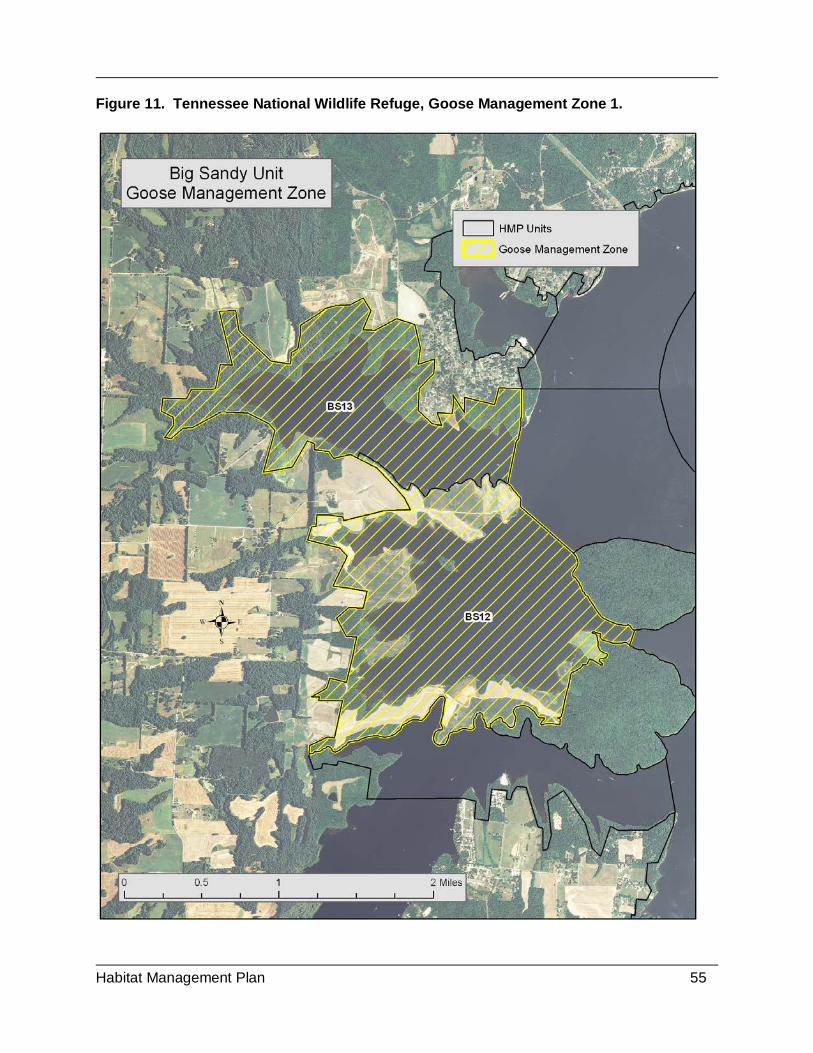
Habitat Management Plan 55
Figure 11. Tennessee National Wildlife Refuge, Goose Management Zone 1.

Habitat Management Plan 56
Figure 12. Tennessee National Wildlife Refuge, Goose Management Zone 2.

Habitat Management Plan 57
meet this objective. The cooperative farmers will be allowed to double crop with winter wheat and the browse produced by this crop will be counted toward the objective if the fields are located in the goose management zones. Under the current water control schedule the drawdown of Kentucky Lake from summer pool (359 MSL) toward winter pool starts around July 5 and steadily drops to winter pool (354 MSL) by December 1. By mid to late August the level typically drops approximately two feet. At this level water is completely off the willow-buttonbush zone, allowing seeds to germinate. Annual grasses and sedges carpet these flats providing browse for migrant geese. This habitat is critical for early migrating geese that start arriving in late September because it is typically the only habitat available at this time of the year, since crop harvest has not yet been initiated. Throughout the fall and winter geese, as well as ducks, heavily utilize the mudflats of Kentucky Lake to feed and loaf. Wirwa (2009) observed Canada geese, green and blue-winged teal, and American wigeon grazing vegetation shoots on mudflats during his study of waterbird use of Kentucky Reservoir. SHOREBIRDS - LATE SUMMER AND EARLY FALL SIGNIFICANCE Many species of shorebirds face significant threats from habitat loss, habitat degradation, and human disturbance. Bart et al. (2007) reported that 23 of 30 shorebird species in the North Atlantic region are declining. There is little existing information for many species that would allow a determination of how shorebird populations have been affected by alterations to their habitat. Despite major ongoing conservation efforts, many shorebird populations are declining. Seven highly imperiled shorebird species and 23 species of high concern are identified in the U.S. Shorebird Conservation Plan (Brown et al. 2001), several of which are in need of management or monitoring in the southeastern United States (Hunter 2002). Among those known to occur on Tennessee NWR are highly imperiled birds such as the piping plover and buff-breasted sandpiper. Birds of high concern include the American golden plover(Pluvialis dominica), solitary sandpiper (Tringa solitaria), upland sandpiper (Bartramia longicauda), western sandpiper (Calidris mauri), short-billed dowitcher (Limnodromus griseus), American woodcock (Scolopax minor), and Wilson’s phalarope (Phalaropus tricolor) (USFWS 2005). Although the western portion of the Central Hardwoods BCR may not be considered among the most important regions in eastern North America for supporting migrant shorebirds, there are still sizeable populations moving through the region and in particular the Tennessee River Valley (Laux 2008, Wirwa 2009, Minser et al. 2011). Migration habitat for shorebirds in the Tennessee Valley is primarily restricted to man altered habitats (i.e., reservoirs and impoundments). Wirwa (2009) reported that almost all habitat is used, suggesting there are more birds moving through than habitat is available. A research project conducted in 2007-2008 found the mudflats of Kentucky Lake to be extremely important to shorebirds (Wirwa 2009). Twenty-six species were documented during this study. Wirwa also found the mudflats to be rich in invertebrates, the primary food for shorebirds. Mean shorebird abundance, richness, and diversity were greatest during September, while mean shorebird density was greatest during August when mudflat acreage was lowest. This indicates that habitat availability is a limiting factor during August. Minser et al. (2011) suggested that the abundance of shorebirds that used Kentucky Lake (Wirwa 2009)

Habitat Management Plan 58
should qualify the area as a “Site of Regional Importance” in the Western Hemisphere Shorebird Reserve Network (WHSRN 2009). WHSRN identifies a location as a “Site of Regional Importance” when at least 20,000 shorebirds use the site annually. Wirwa (2009) estimated approximately 20,000 – 28,000 shorebirds use Kentucky Reservoir each year during fall migration. A shorebird survey route was initiated on the refuge in 2000 as a part of the International Shorebird Survey (ISS) operated by the Manomet Center for Conservation Sciences. This route is located within the lower Duck River Bottoms and covers portions of several of the impoundments. Late winter and spring drawdowns of the impoundments managed for moist-soil and agriculture provide excellent habitat for shorebirds during spring migration. The data from the shorebird surveys supports this observation. The timing and duration of the moist-soil and agricultural impoundments coincides with the spring migration period of most shorebird species. Thus, habitat during spring migration is typically readily available and does not appear to be limiting shorebird populations on the refuge. During the fall when most of the refuge impoundments are in the process of being flooded, shorebird habitat is essentially limited to the TVA’s annual drawdown of Kentucky Lake. The fall drawdown under the Kentucky Reservoir operation schedule (ROS) starts soon after the Fourth of July holiday from summer pool (359’MSL) and reaches winter pool (354’MSL) by December. The recreational boating interest, primarily in the Kentucky portion of the lake, have advocated for a longer summer pool period that extends past the Memorial Day holiday (September 1). In response to these requested changes TVA completed a valley-wide EIS in 2004, which resulted in no changes to the schedule of Kentucky Reservoir (TVA 2004). Other political efforts to alter the operating schedule have occurred since 2004, but no changes have been made to date. Even under the current level operation schedule of Kentucky Reservoir, fall mudflats are not typically available in any significant amount until September. Given that peak shorebird migration through the mid-continental United States occurs July – mid-September (Smith et al. 1991, Twedt et al. 1998, Skagen et al. 1999), mudflat availability for shorebirds in Kentucky Reservoir is limiting during July and August in a typical year. Most long-distance migrant shorebirds of high conservation concern were recorded by Wirwa (2009) during August and September depicting that the period with the least available shorebird habitat within the refuge impoundments or on Kentucky Lake occurs when the highest priority shorebird species need it the most. Thus, refuge habitat management efforts need to focus on increasing mudflat habitat during July – September. IDENTIFICATION OF HABITAT REQUIREMENTS Shorebirds require stopover sites along migration routes that contain high densities of energy-rich organisms (Skagen and Knopf 1993). Invertebrates are the primary forage for shorebirds, with midges (Chironomidae) being very important in freshwater inland habitats (Helmers 1992; Eldridge 1992; Wirwa 2009). It is estimated that an average-sized shorebird requires at least 8 grams of aquatic invertebrates per day to maintain body mass and build sufficient lipid reserves to continue migration (Loesch et al. 2000). Thus, the availability of high quality stopover sites is critical for shorebird population sustainability (Skagen and Knopf 1993, Helmers 1992). Availability of invertebrate foods is an important determinant of habitat quality or migrant shorebirds (Sherfy 1999).

Habitat Management Plan 59
During migration shorebirds utilize a wide range of habitats ranging from coastal to inland wetlands to upland habitats (Helmers 1992). Habitats within the interior United States for most species of shorebirds are typically bare mudflats or very sparsely vegetated wetlands. However, specific habitat requirements vary greatly between shorebird species, due to the wide range of foraging techniques (i.e., gleaning by plovers vs. probing by sandpipers). Adaptations in body size, bill length, and leg length allow the species to partition the habitats, limiting interspecific competition for food resources. A variety of mudflat habitats that support high concentrations of invertebrates are necessary to meet the habitat requirements of the shorebirds migrating through the Tennessee Valley. Mudflat availability will be needed from July through November to cover the critical fall migration period. Specific attention should be given to providing mudflat habitat during July and August when mudflats are typically unavailable and in greatest need by priority shorebird species. Water levels should range from dry to 12 cm in depth to cover the needs of plovers to yellowlegs (Helmers 1992). POTENTIAL REFUGE CONTRIBUTION TO HABITAT NEEDS Sizeable populations of shorebirds migrate through the Tennessee River Valley (Laux 2008, Wirwa 2009, Minser et al. 2011). Habitat for migrant shorebirds is particularly restricted during the early fall migration period and almost all habitat is used, suggesting there are more birds moving through than habitat is available (Wirwa 2009). Given the development of the U.S. Shorebird Conservation Plan and the identified need to provide migration stopover habitat in the region (Brown et al. 2001), it is essential that the refuge work with TVA to preserve the mudflats on Kentucky Lake, as well as providing managed habitat within the impoundments and bottomlands on the refuge. Wirwa (2009) found the mudflats on Kentucky Lake to be very important to shorebirds during fall migration. He estimated that in excess of 20,000 individuals utilize the mudflats on the reservoir. Over a two year period Wirwa documented that that invertebrate density (847 – 2185 invertebrates per m2) and biomass (1.5 – 3.6 g/m2) in Kentucky Reservoir mudflats were similar to those reported at well-known stopover sites. These invertebrate densities greatly exceeded the minimum of 100 per meter that was identified by Eldridge (1992) as a required habitat element to attract shorebirds. Wirwa (2009) reported that foraging was the primary activity of shorebirds on Kentucky Lake mudflats, indicative of the food available and thus the importance this habitat. The Biological Review (USFWS 2005) recommended creating shorebird impoundments on an experimental basis (i.e., one unit at a time) so that potential use can be evaluated before totally committing resources to this management goal. These units need to first be developed at Duck River and need to be no larger than 50 acres each. Small impoundments allow for a more effective management of the vegetation and water depth. If this management strategy proves successful and if it is feasible the refuge should provide up to 200 acres on intensively managed shorebird impoundments during fall migration. The Biological Review (USFWS 2005) suggested focusing on spring migration as well, but habitat should be made available in concert with moist-soil management. The spring drawdown timing associated with managing for agriculture and moist-soil habitats for waterfowl coincides

Habitat Management Plan 60
with the spring shorebird migration period. Thus, the normal management strategies for wintering ducks will also meet the habitat needs of spring migrating shorebirds. UPLAND MATURE FOREST LANDBIRDS SIGNIFICANCE Upland forests on Tennessee NWR currently consists of various age, oak dominated stands ranging from young natural regeneration (under 10 years old) to mature stands of deciduous trees (over 100+ years old). These forests provide habitat for numerous species of upland forest birds, including many listed as species of concern in the CHJV Plan (Fitzgerald et al. 2003), the PIF Interior Low Plateaus Plan (Ford et al. 2000), and the PIF North American Landbird Conservation Plan (Rich et al. 2004). Priority bird species of concern in mature upland forests at Tennessee NWR include the cerulean warbler, worm-eating warbler, wood thrush, Kentucky warbler, Louisiana waterthrush (Seiurus motacilla), whip-poor will (Antrostomus vociferus), yellow-throated vireo (Vireo flavifrons), Acadian flycatcher (Empidonax virescens), yellow-billed cuckoo (Coccyzus americanus), great crested flycatcher (Myiarchus crinitus), and eastern wood-pewee (Contopus virens) (USFWS 2005). The PIF Plan (Rich et al. 2004) has population goals for these species, which still need to be stepped down to the level of the Central Hardwoods Bird Conservation Region (BCR) and Tennessee NWR. The global population goals for many species on the list range from increasing populations 100 percent for the cerulean warbler to increasing populations 50 percent for the wood thrush and Kentucky warbler, and maintaining current populations, which is desired for the remainder of the species listed above. Species of highest conservation concern require specific attention at the refuge and Kentucky Lake area (USFWS 2005). Tennessee NWR lies within a portion of the Central Hardwoods BCR that still remains largely forested. Thus, the forest management efforts on the refuge will be primarily directed towards enhancement of existing forested areas. The forest management strategies outlined in this plan are designed to be in accord with the objectives of the CHJV. A forest habitat management evaluation was conducted at Tennessee NWR in 1996 (USFWS 1996). This evaluation recommended a refuge forest management program concentrating on the upland forested areas and their potential as habitat for a selected assemblage of migratory landbirds. The list of priority bird species for Tennessee NWR was developed based on the Partners in Flight Bird Conservation Plan for the Interior Low Plateau (Ford et al. 2000) and the CHJV Concept Plan (Fitzgerald et al. 2003). IDENTIFICATION OF HABITAT REQUIREMENTS Prior to the establishment of the refuge, most of the forestlands had been used and altered by Euro-American settlement for well over a hundred years. Forests were cleared for farming, resulting in thousands of acres of agricultural lands. Some of the cleared land was marginal but farmed for years and then grazed. Much of this agricultural land was eventually abandoned, producing various stages of poorly stocked timber stands throughout the refuge. Where the topography was not conducive to clearing for agriculture, forest stands were heavily cut for sawtimber and then burned to encourage browse growth for livestock. In the late 1800s, the iron ore industry clear-cut forests in the region to produce charcoal. As a result of these practices, much of the refuge’s forest stands are generally even-aged with closed canopies and a sparse midstory and understory.

Habitat Management Plan 61
The forest habitat management evaluation in 1996 (USFWS 1996) recommended that the refuge implement a forest management program that will enhance nesting habitat for a selected assemblage of forest bird species. Active management is essential to bring the forests of the refuge back to an uneven-aged state. Selective thinning through commercial and non-commercial means is a management strategy that will provide the disturbance to open the canopy and allow understory development. The Central Hardwoods Joint Venture Concept Plan (Fitzgerald et al. 2003) identifies the need to manage forest using timber harvest and prescribed fire for forest-woodland bird species. A Forest Management Plan (FMP) based on the findings of this evaluation was developed for the refuge in 1999. The FMP sought to create more openings in the canopy, and to increase groundcover, understory, and midstory presence, and larger, more developed canopy crowns. A forest prescription using a selective timber harvest strategy was implemented in 2001 within one of the forest compartments on the Big Sandy Unit. The harvest in this compartment was conducted in a manner that would be conducive to conducting research that would determine the impacts of the forest management activities. A study designed in conjunction with Dr. David Buehler of the University of Tennessee was established to test the results of a planned selective timber harvest. The objectives of this research project were to evaluate the impacts of the refuge’s forest management activities on: (1) habitat structure and composition; (2) breeding bird use; and (3) avian breeding productivity. The results of this research demonstrated that the management activity had positive effects on several landbird species (Thatcher 2007). The desired forest conditions in terms of structure will vary with topography and soil moisture; creating a forested habitat that ranges from oak savannas on the excessively dry sites to closed canopy upland mesic forests on the more mesic sites. The end result will be an oak savanna/open oak woodland/closed oak woodland/upland mesic forest continuum that is developed and managed using timber harvest and prescribed fire. POTENTIAL REFUGE CONTRIBUTION TO HABITAT NEEDS Management strategies for mature forest bird species will primarily occur on sites that are most conducive to upland mesic forest and closed oak woodlands. Upland mesic forest should be managed to maintain a canopy closure of greater than 80 percent. Light thinning or single-tree selection can be used, if needed, to release individual trees for crown development and enhance understory development. Forest stands managed as closed oak woodlands should be thinned to basal area range of 50-90 ft²/ac to produce canopy coverage of 50-80 percent and enhance understory development (Nelson 2002; USDA, FS 2005). Group selection cuts will likely be needed on a portion of both upland mesic forest and closed oak woodland sites. Prescribed fire will be low in intensity and frequency and only occur on the dryer sites, promoting patches of forbs and grasses. To potentially control invasive species, herbicide treatments may be necessary. The management strategies for closed oak woodlands and upland mesic forest fall within the recommendations outlined in “The Cerulean Warbler Management Guidelines” (Wood et al. 2013). They recommend uneven-aged management strategies that create small canopy gaps and leave a residual basal area (RBA) of 40-90 ft²/acre. Emphasis should be placed on

Habitat Management Plan 62
retaining large diameter (>16” dbh) white oaks, chestnut oaks, and hickories, since research has found these tree species to be favored nesting and foraging sites by cerulean warblers. GRASSLAND/EARLY SUCCESSIONAL LANDBIRDS SIGNIFICANCE This area, including Tennessee NWR, historically supported habitat for grassland and early successional landbirds. Reestablishing this habitat is a focus of the Central Hardwoods Joint Venture. The presence of grassland habitat on Tennessee NWR is essentially nonexistent. Currently, the only significant area on the refuge that remotely meets the definition of grassland is a major transmission line that TVA maintains along the southern border of the Big Sandy Peninsula. Grasslands though largely absent from the landscape in and around the refuge did once occur as “grassy openings in forest” throughout much of Tennessee, including the Western Highland Rim (DeSelm 1994; DeSelm 1988). Explorers and early settlers who came to Tennessee in the eighteenth and early nineteenth centuries generally called these openings “barrens”. DeSelm (1994) reported that the flora of the remaining barren remnants in Tennessee resembles that of the Midwestern tallgrass prairies. Within the Highland Rim barrens typically occur on shallow limestone-derived soils. Throughout the region grasslands and savannas have been converted to cool season pasture. Many glades and barrens have become urban areas, and others have been overtaken by woody vegetation due to fire suppression. The loss of these grassland plant communities has resulted in significant declines in bird species that require the early successional ecosystems (Fitzgerald et al. 2003; Barrioz et al. 2010). The Central Hardwoods Joint Venture Concept Plan identifies northern bobwhite(Colinus virginianus), blue-winged warbler (Vermivora cyanoptera), prairie warbler (Setophaga discolor), Henslow’s sparrow (Ammodramus henslowii) and field sparrow (Spizella pusilla) as Partners in Flight (PIF) species of regional concern (Fitzgerald et al. 2003). The PIF Watch List for Landbirds has set population goals for the species of greatest range-wide concerns, and which are most in need of conservation attention (Rich et al. 2004). The global population goals for many species on the list range from increasing populations 100 percent for the Henslow’s sparrow to increasing populations 50 percent for the prairie warbler and blue-winged warbler. Dimmick et al. (2002) reported that Northern Bobwhite populations declined across their range by 65.8 percent from 1980 to 1999. To return Bobwhite populations to sustainable levels, in 2002 the Northern Bobwhite Conservation Initiative (NBCI) set the goal of restoring population sizes to 1980 levels. IDENTIFICATION OF HABITAT REQUIREMENTS Fitzgerald et al. (2003) identified the native habitats that support these bird species are glades (grass-dominated ecosystems on shallow soils), barrens, savannas (woodlands with a grass-forb and shrub-dominated understory and less than 50% canopy cover) and early-successional forests. “The distribution of glades, barrens and savannas is largely a result of interactions among topography, aspect, soil types, and historical fire regimes” (Fitzgerald et al. 2003). The literature refers to the open grassland patches within a forested setting as barrens, glades, or savanna. Whether these plant communities are “barrens” or “savannas” is not what is important. The management of forested lands in a way that restores natural plant communities

Habitat Management Plan 63
that existed pre-settlement will provide for a diverse flora and fauna, including priority grassland/savanna landbirds. Based on the terminology that is more prevalent in the most recent literature for the landscape in the vicinity of Tennessee NWR this plan will use the term “oak savanna” to represent the habitat that will be primarily managed for grassland birds within the larger forested setting. Oak savanna has been identified by several authors to have occurred in Tennessee and is now one of the most imperiled ecosystems in North America, as well as Tennessee (Franklin et al. 1994; Yacht 2011; Barrioz et al. 2010; Coffey 2010). Less than one percent of the original oak savanna and woodlands in North America remains today (Yatcht 2011). The reasons given are conversion to cropland or pasture and succession to closed-canopy forest due to the absence of fire. Coffey (2010) stated “From what was described by explorers and settlers years ago as vast and expansive, these communities have all but disappeared from the Tennessee landscape”. Grassland dominated communities can still be found throughout the Central Hardwoods, but often are overgrown and degraded as a result of decades of fire suppression (Fitzgerald et al. 2003). NABCI identifies that savanna restoration in the Central Hardwoods BCR as a management strategy for bobwhite (Dimmick et al. 2002). Oak savanna restoration is not new to the area near the refuge. Franklin et al. (1994) documents work done on Land Between the Lakes by the Forest Service. Tennessee Wildlife Resources Agency is restoring 1,400 acres of oak savanna on Catoosa Wildlife Management Area on the Cumberland Plateau. The CHJV is working towards assisting other public landowners in incorporating savanna restoration in forest management planning. Tennessee NWR’s work within this plan is in an attempt to meet the savanna objectives of the CHJV. POTENTIAL REFUGE CONTRIBUTION TO HABITAT NEEDS The habitat management efforts for grassland and early successional birds on the refuge will primarily occur on sites that are currently closed canopy forests. The desired forest conditions in terms of structure will vary with topography and soil moisture; creating a forested habitat that ranges from oak savannas on the excessively dry sites to closed canopy upland mesic forests on the more mesic sites. The end result will be an oak savanna/open oak woodland/closed oak woodland/upland mesic forest continuum that is developed and managed using timber harvest and prescribed fire. Management strategies for grassland and early successional bird species will primarily occur on sites that are on the driest end of the of the soil moisture gradient. These sites typically occur on the narrow ridges and slopes with a southern exposure. Since these sites are currently forested the initial management will involve moderate to heavy harvest to reduce canopy coverage by 50-90 percent. The driest sites will be managed as savanna with a 10-20 percent canopy cover and will graduate into open oak woodlands, which will have canopy coverage of 20-50 percent. The ground cover will be dominated by grasses and forbs with little woody vegetation in the understory and midstory. Frequent prescribed fire will be necessary to maintain savanna and open oak woodlands. RECONCILING CONFLICTING NEEDS Multiple Resources of Concern are likely to have competing needs or other refuge programs may conflict with habitat needs of Resources of Concern. Recognize when and how these

Habitat Management Plan 64
occur, and how they will be resolved. This may require prioritizing species needs. Prioritization should be resolved by considering refuge purpose(s), NWRS mission, applicable laws and plans. The openness of the landscape desired by geese is in direct conflict with needs of other resources of concern. Wintering black ducks and breeding wood ducks typically utilize habitats with a greater flooded forested and/or shrub component (Gray et al. 2012; Dugger and Fredrickson 2001; Rusch et al. 1989). To reconcile this conflict the refuge chose to designate two goose management zones where the habitat management focus will be on migrant geese. The locations of these goose management zones were chosen based on four criteria: 1) traditional high goose use areas; 2) located within areas that have minimal human disturbance; 3) areas that are mostly open with agriculture, mudflats, and lacustrine habitats; and 4) areas with lower black duck densities. Water management strategies aimed at producing high quality moist-soil habitats for wintering ducks are in conflict with those needed to produce good shorebird habitat during the fall migration. The drawdown timing of the impoundments on the refuge that is done for moist-soil management typically occurs during the spring and early summer, producing mudflats that provide excellent shorebird habitat in the spring. To increase plant survival and seed productivity of moist-soil plants water is added during the dry late summer and early fall for irrigation purposes, eliminating all mudflats. Thus, proper management of moist-soil directly conflicts with fall shorebird habitat requirements. To reconcile this conflict the refuge will need to implement the following strategies: 1) manage at least one of the impoundments at Duck River with a drawdown that occurs during late summer (July-August); 2) develop several small shorebird impoundments that are no more than 50 acres in size and total approximately 200 acres; 3) continue to work with TVA to ensure that the fall drawdown of Kentucky Lake is not delayed. The potential exists that forest management activities, such as tree harvest and prescribed fire, could have impacts on ESA listed bat species. The Indiana bat, northern long-eared bat, and gray bat are the species that are currently listed or candidate species. The management stratigies to open the canopy and enhance a grass-forb plant community for birds are also good management strategies for these bat species. The problem is not the change in habitat conditions but the potential impacts of the management actions required to achieve the desired habitat conditions. Harvest or fire could result in the removal of a tree or snag that is or could be used by bats. Consultation with the FWS ES field office in Cookeville, TN will be necessary to develop strategies to minimize these impacts. The stratigies could include: 1) monitoring to determine the presence of these bats; 2) conducting these management activities outside key periods of the year; and 3) protecting and /or creating important habitat elements (i.e., snags).

Habitat Management Plan 65
CHAPTER IV. HABITAT GOALS AND OBJECTIVES For habitats that require active management, goals and objectives were developed in the Refuge CCP, which are expanded upon or stepped down in this Plan to fulfill the refuge purposes. A habitat management goal is a broad, qualitative statement that is derived from the established purposes and vision for the refuge. Goals and objectives pertain to resources of concern identified in Section 3.0. 4.1. HABITAT MANAGEMENT (CCP GOAL 2) GOAL: Maintain, restore, and enhance diverse and resilient habitats and essential processes necessary to support sustainable populations of migratory and resident wildlife species indigenous to the Lower Tennessee-Cumberland Ecosystem. OBJECTIVE 4.1.1. MOIST-SOIL HABITAT OBJECTIVE (CCP OBJECTIVES 2.1, 2.4, 2.6). Annually manage 1,600 acres of moist-soil habitat to produce 1,000-1,400 acres in DR24-31, DR 35-36, and BS15-17 (See Tables and Figures with a desirable component comprised of 70-80 percent annual cover such as, sprangletop (Leptochloa spp.), yellow nutsedge, Walter’s millet (Echinochloa walteri), barnyard millet (E. frumentacea), tooth-cup (Ammannia coccinea), redroot flatsedge (Cyperus erythrorhizos), bidens (Bidens spp.), smartweed, and keep non-desirables (e.g., sesbania, parrotfeather, purple loosestrife, alligatorweed, aster, woody vegetation, and cocklebur) to less than 20% to help support the foraging habitat needs to meet 121,000-182,000 wintering duck objective. Rationale: Moist-soil impoundments provide foraging habitat, loafing habitat, escape cover and sanctuary for waterfowl, other resources of concern, bald eagles, wading birds, spring shorebirds, and rails. Reinecke et al. (1989) suggested an average of 450 kg/ha (400 lb/ac) of seed might be reasonable because of site and staff limitations. More recently, the LMVJV Waterfowl Working Group used available moist-soil seed estimates of over 500 pounds per acre reported by Kross (2006) to increase the value of this habitat to 1,868 DEDs per acre. Moist-soil habitats with an average seed production of 400-600 pounds per acre on 1,000-1,400 acres will provide for about 15% (approximately 2.2 million DEDs) of the foraging needs of ducks using the refuge. Regardless of the quantity of seed produced, moist-soil impoundments are highly recommended as a means of diversifying habitat (Fredrickson and Taylor 1982, Reinecke et al. 1989) and supplying food with nutrients not generally available in agricultural grains. Moist-soil habitat typically is high in macro invertebrates which benefit wintering waterfowl and other water birds (Fredrickson and Taylor 1982). Sesbania, alligatorweed, aster, woody vegetation, and cocklebur provide very little benefit to waterfowl species, and due to their invasive nature, will quickly cover moist-soil areas, outcompeting native submerged vegetation if not controlled. Moist-soil water management also benefits other species such as, spring shorebirds, rails, wading birds, and butterflies through draw downs. Moist-soil management activity should be carried out in a way in which isolated permanent pockets of tall emergent vegetation will be protected to provide breeding habitat in known historic nesting locations of king rail (Rallus elegans).

Habitat Management Plan 66
Resources of Concern: Wintering waterfowl; breeding wood ducks; black ducks; and shorebirds. Adaptive Management Monitoring Elements:
Primary Habitat Response Variables
Probable Methods
% herbaceous cover (desirable/non-desirable)
Herbaceous cover plots (200-300 meter-square plots for all managed moist-soil habitat annually)
Primary Wildlife Response Variables Probable Methods Wintering waterfowl use
Waterfowl Counts (bi-monthly Nov 1-Feb 28)
OBJECTIVE 4.1.2. SANCTUARY (CCP OBJECTIVE 1.3) Protect high-use wintering waterfowl habitat from human disturbance by closing roads, lands, and waters to public access (sanctuary) from November 15 to March 15 for wintering waterfowl and other migratory birds in Management Units BS12, 13, 15-17, 19, DR17, 23-37, and BT2-4. Additional closures may be needed, especially in the vicinity of the Duck River on the reservoir side of the levee and at Busseltown, Cub Creek, if disturbance from boats becomes an issue. Increase seasonally closed areas by the seasonal closure of all roads on the Busseltown Unit, and consider the closure of the Honey Point Ferry Road on the Duck River Unit. During the sanctuary period minimize disturbance by refuge staff, contractors, and partners conducting inspections, environmental education, maintenance, and management operations as much as possible. Rationale: One of the establishing and acquisition authorities for Tennessee NWR is the Migratory Bird Conservation Act, which calls for use of the refuge as an “inviolate sanctuary,” among other things. During the sanctuary period, the refuge is closed to waterfowl hunting and restricts public access in high waterfowl use areas. There are six state WMAs within a 10-mile radius that allow waterfowl hunting. The refuge’s sanctuary status improves waterfowl hunting on nearby public and private lands, as well as providing opportunities for wildlife observation. Waterfowl sanctuary is a critical part of annual waterfowl conservation and management. Sanctuary provides areas where birds can rest, gain fat, and develop pair bonds that improve the likelihood of successful nesting in the spring and summer. Access is limited during key periods, such as pair bonding, molting, and roosting. Resources of Concern: Wintering ducks; black ducks, and migrant geese. Adaptive Management Monitoring Elements:
1o Habitat Response Variables Probable Methods % of area closed to hunting GPS and Map of closed areas 1o Wildlife Response Variables Probable Methods Wintering duck use American black duck use Migrant geese use
Waterfowl Counts (bi-monthly Nov 1-Feb 28) Incorporate with waterfowl surveys

Habitat Management Plan 67
Visual Observation of species use OBJECTIVE 4.1.3. AGRICULTURE – GRAIN (CCP OBJECTIVE(S): 1.1, 1.2, 2.3, 2.4) In units BS12, BS14-17, BT2-4, and DR17-34, annually manage 3,000-3,500 acres of farmland through the use of cooperative and force account farming to produce 405-495 acres of unharvested corn or an equivalent amount of other grain crops, producing approximately 12.9 million DEDs from November through February. Rationale: The use of agricultural crops as a waterfowl management technique has been well documented in the scientific literature (Bellrose 1980; Baldassarre and Bolen 1984; Delnicki and Reinecke 1986; Ringelman 1990; Combs and Fredrickson 1996; Heitmeyer 2006). Wetland habitats within the Tennessee Valley have been significantly altered by the construction of major river dams and the deforestation of most of the bottomland. With the loss of these natural habitats it has become necessary to utilize agriculture to supplement these losses. Since agriculture crops produce a much greater amount of seed per unit area than natural wetland plants (Kross et al. 2008, Foster 2009) less land is needed to replace the habitat losses that have occurred. Foods that are high in carbohydrates, such as corn, millet, and milo, are essential for providing the energy wintering ducks need to arrive on the breeding grounds in good condition (Ringelman 1990; Petrie et al. 1998; Checkett et al. 2002; Kaminski et al. 2003). Approximately 75 percent of the forage required to meet the objective of 121,000-182,000 ducks for the wintering period of 110 days and 50 percent of that needed to meet the objective of 16,000 migratory Canada geese for 90 days will be provided by unharvested agriculture grain. At least 24 acres of unharvested corn will be retained in traditional goose use areas that are within a largely open landscape (goose management zones). Approximately 75 percent of the unharvested corn on the Duck River and Busseltown units and 25 percent on the Big Sandy Unit will be retained in areas that are capable of being flooded during normal winter water levels. Where the above flooding capacities cannot be achieved the development of additional impoundments will be considered. When crops cannot be flooded they will be made available to waterfowl throughout the wintering period by mechanically knocking the crop to the ground. Overall waterfowl do use harvested grain fields; however, harvested grain fields are not included to meet our objectives because residual seed quantities are frequently unreliable and too low to support waterfowl foraging needs (Foster et al. 2010). In areas where flooding is possible, delay inundation of agricultural crops until late November and early December to coincide with increase in waterfowl densities (Foster et al. 2010). Foster et al. (2010) determined that grain seed deteriorated rapidly when flooded in water. Resources of Concern: Wintering ducks; black ducks, and migrant geese. Adaptive Management Monitoring Elements:
1o Habitat Response Variables Probable Methods Acres of unharvested crops Yield estimates based on sampling plots
GPS and Map acres planted 1o Wildlife Response Variables Probable Methods Wintering duck use American black duck use Migrant geese use
Waterfowl Counts (bi-monthly Nov 1-Feb 28) Incorporate with waterfowl surveys

Habitat Management Plan 68
Visual Observation of species use and grain disappearance
OBJECTIVE 4.1.4. AGRICULTURE – GREEN BROWSE (CCP OBJECTIVE 2.3) In units DR17, DR22, DR 25-26, DR30, DR35, BS12-13, and BT2-3, annually provide 270-330 acres of planted green browse (winter wheat, clover, etc.) through force account and cooperative farming. Approximately 50% of needed forage to meet the objective of 16,000 migratory Canada geese for 90 days will be provided by green browse. Rationale: Providing green browse in addition to grain is important in order to better meet the nutritional requirements of migrant geese. Green browse is high in digestible protein and essential amino acids, which are necessary to sustain winter survival and prepare the geese for important life events, such as migration and egg formation (Austin 1988; Buckley 1989; Austin et al. 1998). Native wetland plants and winter wheat are the primary sources of green browse on Tennessee NWR. Some of the more common native wetland plants that serve as a source of green browse are; spike-rush (Eleocharis spp.), teal grass (Eragrostis hypnoides), and yellow nutsedge. These plants occur on the mudflats of Kentucky Lake and within the internal impoundment moist-soil units. Winter wheat is needed to supplement the natural source of browse. It will be planted in areas of high goose use and is more available during times of flooding on the lake or freezing in the moist-soil units. It is important to provide goose browse within traditional goose use areas and spread throughout the refuge units. Traditional goose use areas consist of open fields with limited woody vegetation and consist mainly of agricultural and moist-soil habitats. Within traditional goose use areas maintain open landscape by keeping shorelines clear of woody vegetation. Resources of Concern: Migrant geese Adaptive Management Monitoring Elements:
Primary Habitat Response Variables Probable Methods Acres of planted crops GPS and Map acres planted Primary Wildlife Response Variables
Probable Methods
Migrant goose use Waterfowl Counts (bi-monthly Nov 1-Feb 28)
OBJECTIVE 4.1.5. FALL MUDFLAT HABITAT (CCP OBJECTIVE 2.5) In Units BS12-13, BS18-19, BS21-24, DR8-18, inform TVA on the importance of fall drawdown schedule that produces 1,500 to 1,800 acres mud flats within the refuge starting in September that support 20,000+ shorebirds and through February for migratory waterfowl (Reservoir water level elevation of 354’ to 357’ MSL). Maintain 25 acres on unit DR35 (Pool 10) and evaluate the feasibility to create additional impoundments or modify water management strategies within existing impoundments on up to 200 additional acres, annually, during July through October. Rationale: In most of the units described above, management for shorebirds is based on overall TVA management of Kentucky reservoir. The refuge will continue to work with TVA to provide

Habitat Management Plan 69
shorebird mud flat habitat which is threatened by ongoing public pressure to modify water management strategies. Some recreational users would like to see higher lake levels year round which is in direct conflict with providing shorebird habitat during fall migration. Mudflats on Kentucky Lake begin to be exposed at an elevation of New Johnsonville gauge height 357’ MSL (Wirwa 2009).
Wirwa (2009) found the mudflats to be extremely important to waterfowl during migration and wintering periods. Native wetland plants that germinate following the fall drawdown provide an excellent source of green browse for geese and wigeon. Green-winged teal are frequently observed feeding on the exposed mudflats, likely finding seeds of the tealgrass and other moist-soil plants. Mallards and other duck species, as well as geese, readily flock to the “nuts” of the yellow nutsedge when the lake levels inundate the flats following significant winter rain events. Wirwa (2009) also documented large concentrations of invertebrates on the mudflats and suggested that waterfowl, as well as shorebirds, heavily utilized the mudflats for this food source. Resources of Concern: Fall shorebirds, migrant geese, wintering waterfowl, and black ducks Adaptive Management Monitoring Elements:
Primary Habitat Response Variables Probable Methods Acres of exposed mudflat Utilize GIS and water level data to
map mud flats within interior impoundments and reservoir
Primary Wildlife Response Variables
Probable Methods
Fall shorebirds use Wintering waterfowl use Migrant goose use
Waterfowl Counts (bi-monthly Nov 1-Feb 28) Shorebird surveys
OBJECTIVE 4.1.6. FLOODED SHRUB HABITAT OBJECTIVE (CCP OBJECTIVE 2.5, 2.6). Inventory and map the shrub wetlands in units DR8-10, DR17-20, DR24-25, DR30-31, DR33-35, DR37-38, and BT1-4. Annually provide at least 1,000 acres of 50-75 percent woody vegetation and/or herbaceous emergent plants and 25-50 percent open water for breeding wood ducks in these units. In units DR24, 30-31, 33-35, and 37 continue to maintain 125-150 wood duck nest boxes. Manage 5-10 percent of the 1,400-1,900 acres of flooded shrub habitat to maintain an early successional stage in units BT1-4, DR17-19, DR24-25, DR31-35, and DR37 for black ducks every 3-5 years. Rationale: Flooded scrub habitat provides ideal cover for breeding wood ducks and their broods (Bellrose and Holm 1994). It also provides essential habitat for pair bonding, foraging, loafing, and roosting activities. Due to the loss of forested wetlands and competition for nest sites from a host of other species, natural cavities are the primary limiting factor to reproduction. Nest boxes are commonly used to supplement natural cavities and increase local production of wood ducks. Locate wood duck nest boxes in areas where suitable nest cavities are likely to be rare. Rusch et al. (1989) reported that within the interior United States the preferred habitat for black ducks is forested wetlands. Chipley (1995) noted that black ducks shifted towards using

Habitat Management Plan 70
forested wetlands, scrub/shrub wetlands, and agricultural habitats in the late winter. Shrub wetlands and forested edges were found to be high use areas for black ducks by the recent research projects at Duck River (Newcomb et al. 2012; Gray et al. 2012). Final reports from these studies are expected within a year and their recommendations will be integrated into black duck habitat management efforts. Other species that flooded forest/scrub habitat benefit include bats, reptiles and amphibians, brood habitat for spawning native fish, and some species of mature forest landbirds, such as prothonotary warblers, orchard orioles, and great crested flycatcher. Resources of Concern: Black ducks, breeding wood ducks and wintering ducks. Adaptive Management Monitoring Elements:
Primary Habitat Response Variables
Probable Methods
Quantity of shrub wetlands available Ration of herbaceous/woody cover to water
ID areas, determine ratio of herbaceous/woody cover to water, monitor changes over 2-5 year period thru use of GIS
Primary Wildlife Response Variables
Probable Methods
Breeding Wood ducks Wintering black ducks Wintering ducks
Wood duck nest box success and banding Wintering Waterfowl surveys (Nov 1-Feb 28)
OBJECTIVE 4.1.7. BOTTOMLAND HARDWOOD MANAGEMENT (CCP OBJECTIVE 2.2, 2.6) Inventory and map approximately 1,900 acres of bottomland hardwoods in Management Units DR3, DR5-6, DR8-10, DR17, DR18, DR19-20, DR 33-37, and DR38 in conjunction with the upland forest inventory for the management unit. Once forest inventory and mapping are complete, develop forest management prescription and manage using commercial and/or non-commercial forest management techniques. Rationale: There are over 2,400 acres of bottomland hardwoods on the Duck River Unit of the refuge. About 500 acres occur on islands and other locations that limit management actions. The remaining 1,900 acres typically consists of small woodlots or riparian buffers between water bodies and other habitat types, such as upland forest and agriculture. The tree composition within much of the bottomland hardwood stands is dominated by pioneer species, such as sweetgum, silver maple, and cottonwood. Very few stands exist that have a strong red oak component (40-50%). The 1,900 acres of manageable bottomland hardwoods can be divided into two separate categories. The bottomland hardwood stands, totaling approximately 1,000 acres, are located along the Duck River and within the Duck River Bottoms. These stands occur in Management Units DR17, DR19-20, DR24-31, and DR 33-37 and are subject to periodic winter flooding. Most of

Habitat Management Plan 71
these stands are on reverted agriculture lands and are composed of pioneer tree species, such as sweetgum, silver maple, and cottonwood. Since very few of these stands have a strong red oak component (40-50%) and winter flooding is possible, these bottomland hardwoods will be managed to increase the composition of hard mast producing species to produce acorns and other mast for wintering waterfowl. A secondary objective will be to retain cavity prone tree species in close proximity to suitable wood duck brood habitat. About 900 acres of bottomland hardwood stands (Management Units DR3, DR5-6, DR8-10, DR18, and DR38) are within or adjacent to the habitat management units that are identified to be managed for upland forest birds. When commercial timber management activities occur in the uplands of a management unit that contains bottomland hardwoods or there is an adjacent bottomland hardwood stand in another unit, the bottomland hardwood stands will also be treated. Most of these management units are located along the Tennessee River and the bottomland hardwood stands will rarely flood during the wintering waterfowl period. The management focus for these bottomland hardwood stands within these management units will be for forest interior landbirds, as well as breeding wood ducks. When a stand is adjacent to a stream or lakeshore it is to serve as riparian buffer and management activities will be limited. In locations where commercial harvest is desirable, the harvest strategies will be similar to those for the upland forest, as described in Objective 4.1.7., with the exception of the retention and enhancement of tree species prone to cavity formation. Species that are prone to cavity formation include; bald-cypress, blackgum, sycamore, and beech (Bellrose and Holm 1994; Fredrickson and Batema 1992). Resources of Concern: Wintering ducks, black ducks and breeding wood ducks. Adaptive Management Monitoring Elements:
Primary Habitat Response Variables
Probable Methods
Forest structure and composition
Forest cruise/inventory sampling (traditional parameters, e.g. BA, overstory, canopy closure, stocking, species composition, midstory, and understory), and number of cavity trees per acre
Primary Wildlife Response Variables
Probable Methods
Wintering ducks Black ducks
Wintering Waterfowl surveys (Nov 1-Feb 28)
OBJECTIVE 4.1.8. HARDWOOD FOREST RESTORATION (CCP OBJECTIVE 2.2, 2.7) By 2013, reforest 104 acres of former agricultural fields in Units BS8, DR17 & DR21 and within the life of this plan harvest 285 acres of plantation loblolly pine stands in Units BS1-BS6, BS8, BS9, BS23-BS26, DR2, DR3, DR5-DR7, DR9, DR11, and BT1 and restore convert to upland hardwood stands through natural succession or by planting. Rationale: The former agriculture fields that are to be reforested are in locations that are no longer profitable for cooperative farming. Each field was assessed according to its potential to meet the objectives outlined in this chapter. It was determined that the best habitat objectives

Habitat Management Plan 72
for these sites would be either upland mature forest or bottomland hardwoods relative to the location of the field. The loblolly pine plantations that are scattered throughout the refuge were mostly planted during the 1960s on sites that were degraded agriculture lands and the primary purpose was for erosion control. The refuge is outside the historic range of loblolly pine and there are no resources of concern on the refuge that require pine woodlands. Thus, these non-native pine stands are to be replaced with upland hardwoods over the next 15 years through commercial harvest and other silvicultural practices to better provide habitat for upland mature forest landbirds. Resources of Concern: Upland Mature Forest Landbirds (Cerulean warbler, worm-eating warbler, wood thrush, Kentucky warbler, Louisiana waterthrush). Adaptive Management Monitoring Elements:
Primary Habitat Response Variables Probable Methods Tree species composition and planting survivorship
Forest cruise/inventory sampling (species composition and survivorship)
Primary Wildlife Response Variables Probable Methods Forest breeding bird species composition & abundance
Breeding landbird survey (point counts)
OBJECTIVE 4.1.9. OAK SAVANNA TO UPLAND MESIC FOREST - CONTINUUM MANAGEMENT (CCP OBJECTIVE 2.2, 2.6, 2.7, 2.8) Complete a forest inventory and site management classification (oak savanna/open oak woodland/closed oak woodland/upland mesic forest) on 11,000 acres in Management Units BS1-11, BS14, BS23, BS25-26, DR1-10, by the life of this plan. When staff and funding are available, manage these forests units to create an oak savanna/open oak woodland/closed oak woodland/upland mesic forest continuum (As described below and referenced from: Nelson 2002; USDA 2005, CHJV pers. Comm.) using timber harvest, prescribed fire, and other chemical and mechanical methods. Rationale: The forests on the refuge typically consist of overstocked, even-aged, closed canopy stands with poor crown development and a sparse understory. Most stands are over one-hundred years old and are a result of regeneration from large-scale clear-cutting that occurred in the late 1800s, along with the absence of periodic fire on the land (USFWS 1996). According to Nelson (2002), the desired forest conditions in terms of structure will vary with topography and soil moisture; creating a mosaic that ranges from oak savannas on the excessively dry sites to closed canopy upland mesic forests on the more mesic sites. Soil moisture, as a result of topographic position, will be the determining factor for the management objectives for a given stand. Commercial timber harvest, prescribed fire, and other chemical and mechanical methods will be the primary management techniques used to achieve the desired forest structure. Oak savannas and open oak woodlands are largely absent from the forests of the region, due to the absence of fire on the landscape. Initially, a heavy to moderate timber harvest will be required to open the existing closed canopy forest to the desired canopy coverage. Prescribed fire will then be used to aid in restoration and continued on at a high frequency to maintain the desired forest structure. Closed oak woodlands and upland mesic

Habitat Management Plan 73
forests presently exist on the refuge, but are in need of management. Moderate to light thinning is needed to enhance understory development, create better crown development, and tree species diversity. Fire will be less frequent and of lower intensity in closed woodlands to largely absent in upland hardwoods, as a result of moisture levels and available fuel loads. The following desired forest conditions are derived from CHJV (personal communication, D. Jones-Farrand, Science Coordinator); Nelson (2002); USDA, FS (2005):
• Oak savannas (listed as “barrens” by the CHJV) are defined as open-grown scattered trees with a ground layer of prairie grasses and forbs. They will typically occur on xeric, steep mid to upper south to southwest-facing slopes and narrow ridges over shallow, well-drained to droughty, often rocky soils. Canopy cover will range between 10-20 percent. The dominant canopy tree species will be chestnut oak, post oak, and scarlet oak.
• Open oak woodlands consist of patches of oaks at irregular intervals with an overall canopy coverage between 20-50 percent; with a sparse midstory and dense ground flora of forbs, grasses and sedges. The open oak woodlands will be interspersed with oak savannas on the southerly slopes and narrow ridges and dominate the well-drained broad ridges. The dominant canopy species will be post oak, chestnut oak, black oak, and pignut hickory.
• Closed oak woodlands will occupy the sites with moderate soil moisture that might
include gentle sloping uplands, steep upper north slopes, and valleys that are not protected from sun exposure. The canopy cover will range between 50-80 percent and be dominated by white oak, black oak, mockernut hickory and shagbark hickory. The understory will have a well-developed small tree and shrub layer, along with scattered forbs and grasses.
• Upland mesic forests will occur on the sites that are most protected from sun exposure and thus more mesic. These sites typically occur on slopes with a northerly aspect and valleys shielded from sun exposure by the adjacent ridges. With the lack of sun exposure these sites are more mesic and thus will rarely burn. Most of the forests on the refuge that fall within the “more mesic” locations are in reality on the drier side of what might be classified as mesic. Nelson (2002) classified these forests as “dry-mesic forests”. The tree species that occupy the canopy within these sites are primarily white oak, yellow-poplar, shagbark hickory, and the occasional northern red oak. Canopy closure will range between 80-100 percent. The understory will be dense to patchy (50-70% cover) and dominated by shade tolerant trees, shrubs, vines, and occasionally ferns.
Resources of Concern: Upland Mature Forest Landbirds (Cerulean warbler, worm-eating warbler, wood thrush, Kentucky warbler, Louisiana waterthrush) and Grassland/Early Successional Landbirds (Northern bobwhite, blue-winged warbler, prairie warbler, Henslow’s sparrow) Adaptive Management Monitoring Elements:
Primary Habitat Response Variables
Probable Methods
Forest overstory Forest cruise/inventory sampling (traditional parameters, e.g.

Habitat Management Plan 74
structure and composition Forest mid- and understory structure
basal area, overstory, canopy closure, stocking, species composition, midstory cover)
Primary Wildlife Response Variables
Probable Methods
Breeding bird species composition & abundance
Breeding landbird survey (point counts)

Habitat Management Plan 75
CHAPTER V. HABITAT MANAGEMENT STRATEGIES ADAPTIVE MANAGEMENT USFWS advocates improving habitat management through adaptive management (http://www.fws.gov/policy/620fw1.html). The Service defines adaptive management as “the rigorous application of management, research, and monitoring to gain information and experience necessary to assess and modify management activities. A process that uses feedback from refuge research and monitoring and evaluation of management actions to support or modify objectives and strategies at all planning levels.” As such, it is imperative that the impact of forest and openland management decisions be evaluated with regard to habitat conditions and wildlife response. MOIST-SOIL MANAGEMENT STRATEGIES POTENTIAL STRATEGIES Preferred moist-soil plants for foraging waterfowl are typically heavy seed producing annuals, such as wild millets, smartweeds, sprangletop, other grasses and sedges (Fredrickson and Taylor 1982). Soil disturbance and moisture are critical for the production of these desirable plants. Failure to set back succession by some form of disturbance (i.e., disking) will allow the succession of perennials, both herbaceous and woody, that out-compete annual plants and greatly reduce waterfowl food production (Strader and Stinson 2005). Therefore, it is critical that the moist-soil areas be maintained in an early successional state using whatever means available if the refuge is to meet its waterfowl foraging objectives. The current objective for Tennessee NWR of 1,600 acres managed to provide moist-soil habitat is based upon a previously reported management capability; recognizing that during a typical year 1,000-1,400 acres will actually produce moist-soil habitat. In any one year up to 200-600 acres of the 1,600-acre potential will be in an agriculture rotation, treated with herbicide, or otherwise in a management state that moist-soil production is minimal. Management techniques employed to promote the growth of desired moist-soil plants include, mechanical and chemical disturbance, agriculture rotations, water level manipulations, and potentially prescribed fire. These actions are used to maximize waterfowl food production and usage. Desirable moist-soil vegetation at Tennessee NWR consists mostly of sprangletop, yellow-nut sedge, wild millet (Walter’s, barnyard), tooth-cup, red-root flatsedge, bidens, and smartweed. Water Management General Duck River Bottoms and Busseltown Bottoms are dewatering areas constructed by TVA in the early 1940’s to control mosquitos through wetland drainage. These areas are separated from Kentucky Lake by levees. With the aid of a series on drainage ditches and pumps, TVA was able to drain the bottoms during the summer to reduce mosquito breeding habitat. TVA operated the pumps for mosquito control until the mid-1960s when they shifted to insecticides.

Habitat Management Plan 76
The levees and pump stations associated with these dewatering areas were maintained to some degree by TVA until 1993. At that point, the refuge assumed all operation and maintenance responsibilities for the infrastructure associated with these dewatering areas. Over the last decade the refuge has made several improvements in the Duck River Bottoms outer levee, including tree removal, spillway construction, riprap armament, surface gravel, and water control structure replacement. Operation of the pumps at Duck River has varied over the years. TVA operated and funded the pumping of the bottoms through 1966. After that, a period of fourteen years passed without any pumping to drawdown water in the Duck River Bottom. Refuge management reported a loss of 900 acres of farmland as a result of TVA discontinuing pumping operations. In 1979, TVA and the refuge refurbished the pump station and pumping began again in 1980, but again ceased in 1982 due to budget issues and a change in managers and management strategies. The pumps were again idle for fourteen years, until 1995. In 1993, TVA again refurbished the pump station but turned the maintenance and operation over to the refuge. Beginning in 1995 pumping was resumed and has continued to present date, with all costs absorbed by the refuge. Pumping has resulted in a significant increase in moist-soil acreage. At an average annual electricity use cost of $20,000 the operation of this pump tripled the moist-soil habitat acreage, improved the security of cooperative farming, and allowed the planting of agriculture crops in more locations that could be flooded. The continued operation of this pump will eventually require a significant rehabilitation of the ageing pump station and associated components. The pump station at Busseltown has been non-functional for decades and now simply functions as a screw gate water control structure. There are 26 managed impoundments of various sizes on the refuge. Nineteen are on the Duck River Unit, of which 12 were constructed in the 1980’s inside the outer levee of the Duck River Bottoms. Four of the impoundments are at Busseltown; including the pool formed by the original Busseltown Dewatering Area and three small impoundments located in the agriculture fields. There are three small impoundments on the Big Sandy Peninsula that total approximately 50 acres. Each impoundment on the refuge has a minimum of one water control structure with some having several to facilitate the movement of water to adjacent impoundments. Most of the water control structures have been replaced over the last decade, but maintenance of these structures is a continual process. Some of the internal levees have been improved but many of the levees constructed in the 1980’s in the Duck River Bottoms need significant work to improve the slope for structural stability and maintenance purposes. Annual maintenance of the infrastructure associated with the impoundments takes a significant amount of staff time and operating funds. Flood damage to the levees over the years has consumed a staggering amount of resources and made it difficult to focus on routine maintenance. Water level manipulations intended for moist-soil management purposes on Tennessee NWR are driven by several factors that the refuge staff sometimes has minimal control over. These factors are refuge-specific limitations that have to be taken into consideration and adapted into the moist-soil management strategies. The primary limiting factors are: 1) constraints associated with the reservoir operation schedule of Kentucky Lake; 2) constraints associated with infrastructure; and 3) impacts of spring floods. Impacts of the Kentucky Lake Operations

Habitat Management Plan 77
TVA has reserved all rights on flood control, navigation, and power production for Kentucky Lake. Water management within refuge-controlled impoundments is impacted by the water levels of the reservoir. Annual water level fluctuation on Kentucky Lake is the opposite of what is needed for water management within the refuge impoundments. Kentucky Lake’s managed pool levels are highest in the summer and lowest in the winter. Normal summer pool is 359' MSL with a drawdown to 354' MSL during the winter months. The lake begins the rise to summer pool level on April 1 reaching full pool on May 1, which coincides with the desired initiation of moist-soil drawdowns. Most of the moist-soil areas on the refuge are below the summer pool level of Kentucky Lake. To adapt to this schedule, the refuge releases some water in early March to reduce the cost of pumping. This release is too early for the growth of some of the more desired moist-soil plants. Thus, the operation of the pumps at New Johnsonville pump station is required to manage for the quality and quantity of moist-soil habitats identified in the objective. Kentucky Lake drawdown begins July 5, gradually dropping to winter pool on December 1, which limits the use of water in Kentucky Lake to flood moist-soil habitat. This schedule allows some use of lake water during the late summer and early fall to irrigate moist-soil units and to provide habitat for rails and early migrating waterfowl, such as blue-winged teal. Most of the water needed to flood moist-soil comes from rainfall runoff and some pumping with the use of the Duck River pump. The installation of a pump at the upper end of Duck River Bottoms in 2011 greatly enhanced the availability of water for flooding habitat, especially during dry falls. Infrastructure Limitations and Issues Some of the levees that were constructed in the 1980’s are difficult to maintain because the slope is too steep and in some cases are at risk of failure. Work has been done on a few levees to get them to a maintainable state. Most of the levees have received repairs to bring them back to grade following flood damage but funding has been insufficient to improve the side slopes. Leakage is a problem in several impoundments, especially the Duck River Bottoms pools adjacent to the outer levee. It is anticipated that these impoundments leak through sand or gravel veins that allow water flow under the levee. Little can be done, feasibly, to correct this problem, thus limiting management capabilities. Pool 7 (DR31) and Pool 9 (DR33) have the greatest leakage problems. The levees constructed within the Duck River Bottoms in 1980’s created very large impoundments that range in size from 100-1,200 acres. Topographic relief within most of the pools is around five feet. Excessive pool size and relief create problems managing moist-soil habitats. It is extremely difficult to maintain the necessary soil moisture throughout a moist-soil unit under these conditions. Typically the higher elevations become too dry and undesirable plants, such as cocklebur dominate. Thus, it is impossible to have quality moist-soil throughout most of the impoundments on the refuge. Decisions between quantity vs. quality are frequently required. Excessive water is also required to fully flood the impoundments and care has to be taken to not overtop food resources prior to dabbling duck utilization. Nuisance animals, specifically beavers (Castor canadensis), have adapted to utilizing manmade structures to serve as dams and lodging, significantly impacting the movement of water and the infrastructure integrity. Water control structures are frequently and easily used as dam locations due channeled water flow. Continual monitoring and dam removal is necessary to prevent adverse impact on moist-soil habitats as a result of a lack of water control. Beavers and muskrats (Ondatra zibethicus) frequently utilize levees as a site to construct a lodge by

Habitat Management Plan 78
burrowing into the levee just under the water line. This activity will weaken the structure and can eventually result in a breach. Control of these nuisance animals is necessary in order to protect the integrity of the levees and to properly manage water levels. Impacts of Spring Floods Growing season floods have the greatest impact on water management plans than any other limitations addressed above. Uncontrolled floods have overtopped the outer levee of the Duck River Bottoms during the growing season in 14 of the last 20 years. With a 70% occurrence rate, annual flooding is an expected event. Flooding of the refuge comes from two sources; 1) localized and Tennessee Valley rain events and/or 2) USACE withheld releases from Kentucky Dam during major flood events. Localized heavy rain events in the Duck River watershed (usually greater than 5 inches) will put the Duck River above flood stage, quickly over-topping the outer levee and flooding the Duck River Bottoms. Busseltown is located in the headwaters of Kentucky Lake and is more influenced by the fluctuations of the Tennessee River as a result of releases from Pickwick Dam. Localized heavy rainfall in the Tennessee Valley could result in the flooding of Busseltown Bottoms. A major purpose of Kentucky Lake is for flood storage to protect properties along the Ohio and Mississippi Rivers. The USACE takes charge of the water release from Kentucky Dam when these rivers approach flood stage at various locations. When the release from Kentucky Dam is significantly reduced to lessen the flooding on the downstream rivers, Kentucky Lake can slowly rise to a point that the Duck River, Big Sandy, and Busseltown levees are overtopped, flooding all the lower elevations on the refuge. Floods of this cause have occurred in the past when the local area has received little to no rainfall. The immediate impacts of a flood event are the damage to levees and roads that occur due to the scouring force of the flowing water. If the flood occurs after some of the farming occurs, the inundated agriculture crops will be lost. Flood events usually last for a month or more; significantly delaying the planting of crops and drawdowns for moist-soil management. The later in the year that the flood occurs, the greater the impacts on waterfowl habitats. An early spring flood can easily be overcome as it relates to habitat. The later the flood, the more adverse the impacts are on moist-soil habitat. Drawdowns late in the season are usually faster and occur during hotter and dryer periods than planned, resulting in more rapid drying of the soil. Thus, the moist-soil quality will be potentially diminished by the presence of more undesirable plants, such as cocklebur. Water Management Techniques for Moist-Soil Production Drawdown and flood-up schedules play a significant role in determining the plant community, seed production, and wildlife use of a specific moist-soil unit. The specific water management techniques are: 1) season of drawdown; 2) speed of the drawdown; 3) variation of drawdowns for plant diversity; and 4) timing of flood-up. Season of Drawdown

Habitat Management Plan 79
The time of year that a drawdown occurs has a great impact on the species of plants that germinate and eventually dominate the plant community. The growing season has been divided into three periods that typically result in somewhat differing plant communities. These periods are early season, mid-season, and late season. These periods are generally defined by changes in weather variables, such as temperature and rainfall. However, it should be understood that unusual weather patterns, such as drought, flooding, and abnormal temperatures, can greatly alter the expected plant community. Early season drawdowns at the latitude of Tennessee NWR occur in March and April. The expected desired plant community may contain Pennsylvania smartweed, nodding smartweed (P. lapathifolium), beggarticks, and spike rush. Undesirable plants that are promoted by an early season drawdown include aster and black willow. Most of the impoundments on the refuge contain both agriculture and moist-soil habitats. Typically, the farm fields are located in the higher elevations with moist-soil areas at lower elevations. Corn and soybeans are the preferred crops of the cooperative farmers and an early drawdown is necessary in areas with fields managed under a cooperative farming program. Early season drawdowns coincide with spring shorebird migration and provide excellent mudflat habitat. Mid-season drawdowns occur in May and June, typically producing stands of greater plant diversity than the other drawdown periods. Barnyardgrass, Walter’s millet, yellow-nut sedge, nodding smartweed, beggarticks, tooth-cup, redroot flatsedge, and red sprangletop are the common desirable moist-soil plants. Problem plants that also respond to mid-season drawdowns are black willow and cocklebur. Due to the frequency of uncontrolled spring flooding, moist-soil plant communities produced by mid-season drawdowns occur more often on the refuge than early drawdowns. Late season drawdowns (July and August) should be used with caution and on a limited basis. They are typically used to meet objectives (i.e., fall shorebirds and early goose browse) other than moist-soil habitat. Seed production can be much lower and there is a greater risk of undesirable plants dominating the plant community. However, late season drawdowns are a good management tool that will be used under specific conditions. The desirable plants that respond to late drawdowns are yellow-nut sedge, teal grass, and tooth-cup. Sesbania and/or cocklebur, which are undesirable, can dominate a stand. Late drawdowns also promote the growth of alligatorweed by keeping the impoundment flooded later. This also limits the control of this species, since most herbicides have proven to be ineffective on alligatorweed when it is in water. Late season drawdowns occur when shorebird habitat is absent on Kentucky Lake and at a critical period when some high priority species migrate through Tennessee. Speed of the Drawdown Fast drawdowns are completed within a matter of days to a few weeks, depending on the size of the impoundment. These are typically done in the early spring or following uncontrolled flood events with a primary purpose of drying agriculture fields. For moist-soil management purposes fast drawdowns should only occur during the early season period when rainfall and lower temperatures will maintain soil moisture high enough to promote the germination of desirable plants. A disadvantage of utilizing this type of drawdown is that mudflat habitat availability for shorebirds is completely lost in this short time frame. Slow drawdowns are staggered over a longer period of up to a month, according to the size of the impoundment. This is the technique of choice for moist-soil management in southern

Habitat Management Plan 80
latitudes. The advantages of slow drawdowns include; extended habitat availability and foraging times for migrant waterbirds, elevated soil moisture which promotes desirable annual seed producers, decreased probability of germination of undesirable species, gradually decreasing water depths that benefit many species of wildlife, and potentially higher yields of annual moist-soil plants. One disadvantage of using a slow drawdown is the potential to have exposed mud flats during the period when black willow is scattering seeds, which can result in a large acreage of young willows. Variation of Drawdown Strategies for Plant Diversity It is important to utilize all the drawdown techniques addressed above in order to produce a diversity of moist-soil plant communities throughout the refuge. This should occur within the same year by staggering the drawdown schedules between impoundments as much as possible. This can also be accomplished within an impoundment by stair-stepping the drawdown to occur across multiple periods. Of course, variation is easier planned than accomplished. The greatest constraint is the probability of an uncontrolled flood, with funding for a prolonged pumping period being another problem. Timing of Flood-up The flood-up of moist-soil habitats will begin as early as August within some impoundments. Irrigation of established moist-soil plants during the dry summer can enhance seed production. This water also provides habitat for early migrating blue-winged teal, rails and bitterns, which begin arriving in early August. Care should be taken to not overtop the vegetation during the growing season. Once the plants have matured the fall flood-up should occur as the moist-soil food resources are depleted and will be in increments that do not exceed six inches. Efforts should be made to provide newly flooded moist-soil habitat throughout the fall migration and wintering period. However, the flooding of moist-soil may vary depending on water availability, waterfowl usage, and weather patterns. Mechanical Disking Maintenance of good seed production in moist-soil requires a periodic soil disturbance. Disking is one of the most viable options available to managers as physical manipulation of the soil is necessary to set back succession, control undesirable plant communities, and rejuvenate moist-soil units that are producing low yields. Manipulations are required as seed producing annuals are replaced by perennial plants, which could occur every three to ten years. Proper disking technique is also important, as many factors determine the outcome of this manipulation. Most often, more than one pass over a unit is required as the soil may initially be left in clods and clumps. If the soil is left in this condition, plant communities will develop that are less than desirable due to the micro-environments created as the soil dries unevenly. By making additional disking passes over the unit, the clumps and clods are broken down into a more homogenous seed bed, which creates conditions that are more conducive to the germination of desired annual seed producers. The use of a cultipacker can also aid in providing a good seed bed.

Habitat Management Plan 81
Disking can occur during the period of spring to early fall. Disking in the months of April, May, and June are typically aimed at producing annual grasses in that calendar year. Disking in July, August, and September targets invertebrate production and late germinating species for that season, and annual grasses the following growing season. Caution should be taken when disking during the late season without the planting of millets, buckwheat or winter wheat, as it is very conducive to the germination of undesirable plants. Caution should also be used in deciding what areas are suitable to be disk. There are many areas on the refuge that will never dry sufficiently to support equipment. Other means to set back succession will be required on these sites. Options for inaccessible locations include aerial application of herbicides and deep flooding through the growing season. Locations that contain alligatorweed should not be disked unless the site has been treated with a herbicide prior to disking. Disking has been found to spread alligatorweed, since this plant easily spreads from cuttings. Mowing Moist-soil units are typically comprised of desirable and undesirable plant species. Undesirable plants are defined as those species which have either an established mono-culture or have begun to interfere with the production of seed or tuber producers at a specified level (greater than 50% of the moist-soil area). These species often include broadleaves such as cocklebur, which are particularly susceptible to mowing with a rotary mower, and can be successfully controlled when clipped below the meristem after reaching a height of 12 inches or more. Removal of the overstory allows sunlight to reach the ground, which promotes and releases the grass species that are growing underneath the broadleaf canopy. The greatest benefit derived from mowing occurs after the dominant overstory plants have become well developed, and are effectively stopping sunlight from reaching the ground. This technique should be applied during the months of June through September. Mowing applied in June or July will result in an improved annual grass and broadleaf community, while mowing in August and September will provide a coarse substrate for invertebrate production after flooding. Herbicide Treatment The presence of invasive plant species can alter the function of ecosystems due to the loss of wildlife habitat, displacement of native species, change in carrying capacity from reducing native forage production, lower plant diversity, and increase soil erosion and soil sedimentation. These negative effects decrease the biological integrity, diversity and environmental health of the refuge; and therefore, require a management strategy that will control, and if possible, eradicate the invasive species. Known invasive aquatic plants that occur in moist-soil habitats on the refuge and potentially need control are alligatorweed, parrotfeather, and purple loosestrife. Significant resources should be focused on determining the extent of each invasive species on the refuge and to controlling their spread. Successful control requires careful planning, implementation, and monitoring. Native plants can also be very invasive in moist-soil units. The species with the greatest impact on moist-soil management on the refuge are knot grass, Sesbania spp., black willow, silver

Habitat Management Plan 82
maple, bald cypress, cocklebur, and aster. Where mechanical means are not feasible, such as in wet ground, herbicides provide an effective management tool to control invasive native plants. Herbicides will be used primarily to supplement, rather than as a substitute for, control measures of other types. Whenever an herbicide is needed, the most narrowly specific pesticide available for the target organism in question should be chosen, unless considerations of persistence or other hazards would preclude that choice (7 RM 14). All herbicides will be approved through the Pesticide Use Proposal process and will follow Integrated Pest Management Policy (569 FW 1). Herbicide use will meet all State and Federal permitting regulations. Herbicide applications can be made using various application means. Spot treatments can be done using handheld or vehicle mounted sprayers. Tractor or ATV mounted boom sprayers can be used to cover larger areas. Aerial application with helicopters is commonly used in locations that are inaccessible with ground equipment. Farming Farming, either cooperative or force account, can serve as a disking and/or herbicide treatment in moist-soil units to set back succession, while still providing food for waterfowl. Disking and/or herbicide treatments that are used to prepare the land for the crop will set back succession for moist-soil habitat in the following year. The crops normally planted in these areas are corn and millet, with the occasional plantings of grain sorghum, chufa, and buckwheat. Cooperative Farming Cooperative farming serves as a moist-soil management tool on a limited basis in areas that are occasionally rotated into moist-soil. This should only occur within established farm fields that are in agriculture at least every other year. Force Account Farming Moist-soil areas that are disked for soil disturbance can be planted in a crop by refuge staff. Most moist-soil units on the refuge do not dry sufficiently to allow disking early enough in the growing season for desirable plants to germinate. Summer disking, without planting a crop, will likely lead to a plant community dominated by undesirable plants, such as cocklebur. An established crop will provide competition against the weeds, as well as providing a food resource. SELECTED MANAGEMENT STRATEGIES AND UNIT PRESCRIPTIONS To meet Objectives 4.1.1 and 4.1.5, in Management Units DR24-31, DR 35-36, and BS15-17 for wintering waterfowl, shorebirds, black ducks, and breeding wood ducks the following strategies will be used to manage moist-soil habitat:
• Annually, develop and implement a water management schedule (drawdown and flood-up) for the refuge impoundments. Be sure to have variation in this plan from year to year as much as possible to reduce invasive plant issues. Be prepared to adjust this schedule due to uncontrolled flooding.

Habitat Management Plan 83
• Stagger drawdowns within and among impoundments throughout the spring and summer to create a more diverse plant composition.
• The initial drawdown for units with agriculture habitat will begin around March 1 while Kentucky Lake is near the winter pool level.
• Conduct an early season drawdown for a few moist-soil impoundments around March 15 by gravity flow into Kentucky Lake. The early season drawdowns in March will be fast to quickly expose the agriculture fields, allow for storage of spring rainfall, and to potentially reduce pumping costs.
• Conduct mid-season drawdowns on the majority of the moist-soil units from early May through June. For the impoundments in the Duck River Bottoms this will require the operation of the New Johnsonville pump station. The mid-season drawdowns should be at a slow rate, removing no more than an half of a tenth of a foot a day.
• Conduct a slow late season drawdown during July and August within a few impoundments with a primary focus of providing shorebird mudflat habitat.
• When possible the drawdowns should be done in stages that allow the soil to remain moist until seed germination occurs. A rough guide is to conduct a slow half foot drawdown over a two week period and then hold that level. Once the plants have germinated continue the slow drawdown in half foot increments.
• Begin the flood-up of moist-soil habitats in August to provide irrigation to enhance seed production and plant survival during dry periods.
• Continue flooding the moist-soil habitats into the fall and winter as the habitat is needed by waterfowl. Habitat use will need to be monitored to determine the need for additional flooded moist-soil. Be careful to avoid overtopping underutilized moist-soil habitat.
• Record water level data for all impoundments at the beginning and middle of each month and daily when water is being moved between impoundments. Install gauges in impoundments where they are absent.
• Improve water management capabilities within moist-soil units by 1) subdividing the existing impoundments to create smaller impoundments; 2) improving water supply via wells, pumps and additional water control structures; and 3) renovating existing levees and water control structures.
• Monitor plant responses within the first 30 days of drawdowns or water manipulations and if the plant response is undesirable alter the water management schedule as needed if possible.
• Maintain at least 50 percent of the plant composition in each moist-soil unit in plant species considered to be of good to fair food value for waterfowl.
• If undesirable vegetation reaches 20-50%, management strategies such as, chemical, mechanical, water management, and/or farming should be utilized to control these species.
• Conduct moist-soil plant composition surveys to assist in judging when moist-soil units should be disked or disturbed by other methods. Consider incorporating the use of models to predict seed and aquatic invertebrate production in conjunction with the composition surveys.
• Disturbance activities designed to keep moist-soil units in early successional stages should have a rotational management scheme so that the plant community is diverse.
• Disturbance by some means should occur every 2-5 years depending on the plant community composition.
• Utilize disking as a soil disturbance during the spring and early summer and under soil conditions where desirable moist-soil plants will germinate.
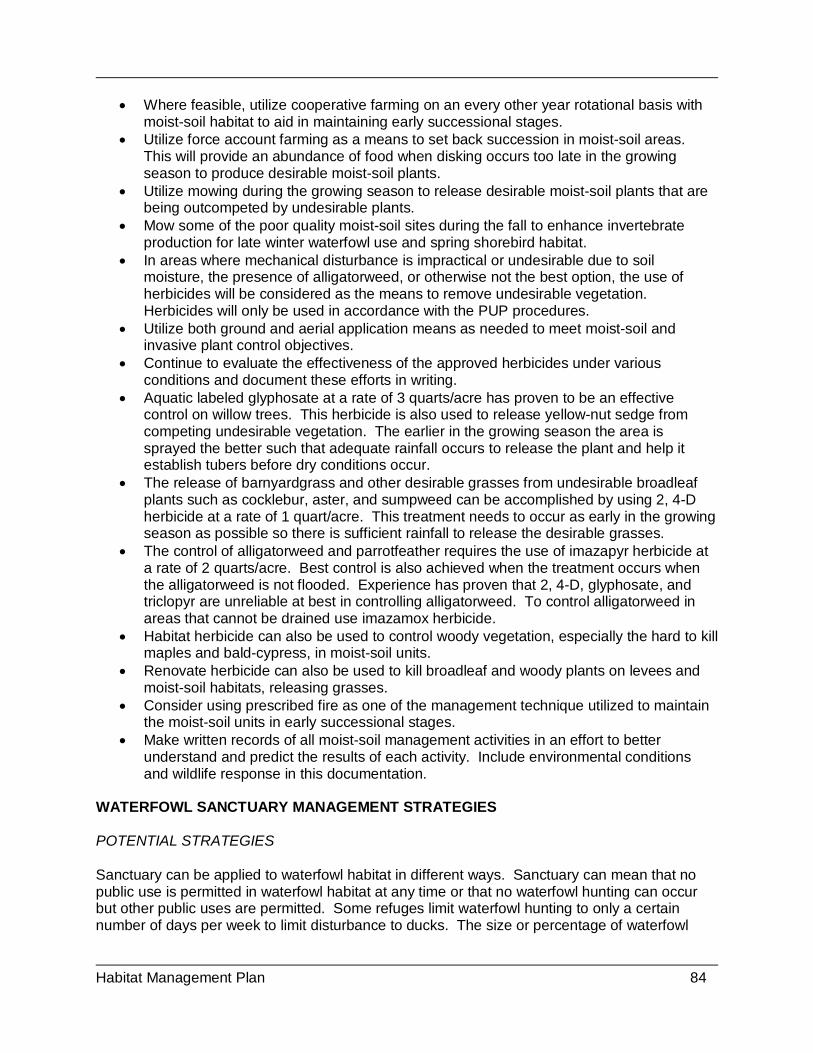
Habitat Management Plan 84
• Where feasible, utilize cooperative farming on an every other year rotational basis with moist-soil habitat to aid in maintaining early successional stages.
• Utilize force account farming as a means to set back succession in moist-soil areas. This will provide an abundance of food when disking occurs too late in the growing season to produce desirable moist-soil plants.
• Utilize mowing during the growing season to release desirable moist-soil plants that are being outcompeted by undesirable plants.
• Mow some of the poor quality moist-soil sites during the fall to enhance invertebrate production for late winter waterfowl use and spring shorebird habitat.
• In areas where mechanical disturbance is impractical or undesirable due to soil moisture, the presence of alligatorweed, or otherwise not the best option, the use of herbicides will be considered as the means to remove undesirable vegetation. Herbicides will only be used in accordance with the PUP procedures.
• Utilize both ground and aerial application means as needed to meet moist-soil and invasive plant control objectives.
• Continue to evaluate the effectiveness of the approved herbicides under various conditions and document these efforts in writing.
• Aquatic labeled glyphosate at a rate of 3 quarts/acre has proven to be an effective control on willow trees. This herbicide is also used to release yellow-nut sedge from competing undesirable vegetation. The earlier in the growing season the area is sprayed the better such that adequate rainfall occurs to release the plant and help it establish tubers before dry conditions occur.
• The release of barnyardgrass and other desirable grasses from undesirable broadleaf plants such as cocklebur, aster, and sumpweed can be accomplished by using 2, 4-D herbicide at a rate of 1 quart/acre. This treatment needs to occur as early in the growing season as possible so there is sufficient rainfall to release the desirable grasses.
• The control of alligatorweed and parrotfeather requires the use of imazapyr herbicide at a rate of 2 quarts/acre. Best control is also achieved when the treatment occurs when the alligatorweed is not flooded. Experience has proven that 2, 4-D, glyphosate, and triclopyr are unreliable at best in controlling alligatorweed. To control alligatorweed in areas that cannot be drained use imazamox herbicide.
• Habitat herbicide can also be used to control woody vegetation, especially the hard to kill maples and bald-cypress, in moist-soil units.
• Renovate herbicide can also be used to kill broadleaf and woody plants on levees and moist-soil habitats, releasing grasses.
• Consider using prescribed fire as one of the management technique utilized to maintain the moist-soil units in early successional stages.
• Make written records of all moist-soil management activities in an effort to better understand and predict the results of each activity. Include environmental conditions and wildlife response in this documentation.
WATERFOWL SANCTUARY MANAGEMENT STRATEGIES POTENTIAL STRATEGIES Sanctuary can be applied to waterfowl habitat in different ways. Sanctuary can mean that no public use is permitted in waterfowl habitat at any time or that no waterfowl hunting can occur but other public uses are permitted. Some refuges limit waterfowl hunting to only a certain number of days per week to limit disturbance to ducks. The size or percentage of waterfowl

Habitat Management Plan 85
habitat that is sanctuary varies also. Sanctuary can be in any habitat type used by waterfowl. Strickland and Tullos (2009) recommend 20-25% of waterfowl habitat be in sanctuary to reduce disturbance. Sanctuary should be available in all habitat types, including moist-soil, agriculture and bottomland hardwood forest (USFWS 2004b). Human disturbance of waterfowl is not just limited to what is caused by various public use activities that occur on refuges. Disturbance can result from routine and periodic refuge operations by Service personnel and partners (i.e., TVA, TWRA, universities). These operations involve management activities that occur on a regular basis, such as water management actions, crop manipulations, and winter waterfowl banding activities. Other operations that are more irregular in occurrence include emergency repairs to infrastructure, environmental education programs and events, law enforcement patrols, inspections, contract project work, and wildlife research projects. SELECTED MANAGEMENT STRATEGIES AND UNIT PRESCRIPTIONS To meet Objective 4.1.1, 4.1.2, 4.1.3, 4.1.4 and 4.1.5 in Management Units BS12, 13, 15-17, 19, DR17, 23-37, and BT2-4 for migrant geese, wintering waterfowl and black duck, the following management strategies will be used:
• Protect high use wintering waterfowl habitat from human disturbance by closing roads, lands and waters to public access November 15 – March 15.
• Continue with the current closures in the impoundments, bays (Big Sandy Unit), and associated lands in the Big Sandy, Duck River, and Busseltown Units listed above.
• Starting in 2015, reduce the waterfowl disturbance in the Busseltown Bottoms by initiating the process (public informational meetings, website, news releases, etc.) of closing Mouse Tail Landing Road to public access from November 15 – March 15. Also consider closing Cub Creek if disturbance from boats becomes an issue.
• Consider additional closures in the vicinity of the Duck River on the reservoir side of the levee such as the area out from Pool 1 and 10 and the Duck River channels along Pool 9 outer levee, if disturbance from boats becomes an issue.
• Better identify areas closed to disturbance, especially to non-consumptive users. Include closed areas in brochure or map form that can be handed out to decrease disturbance and increase signage throughout the area.
• Carefully evaluate refuge operations that occur within sanctuary areas as to the impacts they have on waterfowl. If at all possible, personnel should stay out of the most sensitive areas during critical periods and times of the day (i.e., feeding, roosting, pair-bonding, high use black duck areas). Consider adjusting times of entry and routes of travel to avoid excessive disturbance.
• Develop a map that illustrates the portions of the refuge that are designated as waterfowl sanctuary.
FARMING MANAGEMENT STRATEGIES POTENTIAL STRATEGIES Agricultural crops can significantly contribute to the nutrition and fitness of wintering waterfowl, migrant geese and black ducks; as they provide a source of high-energy carbohydrates needed during periods of cold weather. Agriculture crops, especially corn, produce a much greater yield per unit area than natural wetland plants. This allows the refuge to support more waterfowl
Habitat Management Plan 86
throughout the wintering period than would be possible with the limited areas of natural habitat. The refuge must provide agricultural habitat in the form of grain and browse to meet the foraging objectives for wintering waterfowl as identified in the CCP. Options for the manager include the selection of a crop species, the agronomic system under which the crop will be grown (i.e., traditional row crop, broadcast, no-till, etc.), options for weed management, and whether the work will be accomplished by a cooperative farmer or by refuge personnel and equipment (“force account”). Cooperative farming has been selected as the primary arrangement of choice for Tennessee NWR. Force-account farming will only be used as a last resort to accomplish refuge objectives should cooperative farming be removed as an option (See Appendix B). Force account farming will be used as a means to make up shortfalls in meeting objectives and as a tool to manage moist-soil habitat. Cooperative farming is an essential component of the refuge meeting its waterfowl foraging habitat objective. Cooperative farming has been and will continue to be a cost-effective mechanism to provide the high-energy foods required to support high numbers of wintering waterfowl. Force account farming by the refuge provides some grain and green browse to better meet waterfowl forage objectives. Most of the force account farming that produces grain is also a means of managing moist-soil units. Corn is the most common grain crop planted for waterfowl in the Tennessee Valley. Millet and milo are also planted by waterfowl managers. Winter wheat is typically planted as browse for geese. Currently around 3,000–3,300 acres of farmland are planted on an annual basis. Most of the farmlands (85-90%) are managed under a cooperative farming program, but 10-15% is farmed force account, in which refuge staff farm, occurs each year. Cooperative farming and force account farming methods utilized on the refuge include the planting of row crops (corn, milo, soybeans, and wheat) to provide food for migratory waterfowl. Five cooperative farmers currently plant row crops on the refuge. It is preferred to have a different farmer on each unit to better insure that crops are planted and harvested in a timely manner. The refuge share of the crops that is planted by the cooperators ranges from 15-25 percent, depending upon the potential productivity of specific farmlands. Pesticide Treatments The use of agricultural pesticides, in the form of herbicides, insecticides, and fungicides has become an essential tool for the modern farmer. Without chemicals the yield potential for agriculture crops will fall below the economic threshold needed to turn a profit. Cooperative farmers will be allowed to utilize approved pesticides to protect their crops and enhance production. All chemicals will be approved through the Pesticide Use Proposal process and will follow Integrated Pest Management Policy (569 FW 1). Herbicide treatments allow for very selective removal of plant species or groups of species, with little or no damage to crops that are considered desirable. Insecticides and fungicides reduce the impacts of insects and fungal diseases on crops, protecting the crops and increasing the yield potential. Pesticides will be applied according to the directions on the label, and used solely for the purpose for which the chemical was designed. A list of permissible herbicides is maintained within the Pesticide Use Permit Database. Forage Needs

Habitat Management Plan 87
To meet the recommended duck and goose objectives advanced under Goal 1, the refuge farming program would need to produce approximately 374 acres of unharvested corn or an equivalent grain (i.e. milo or millet) that averages 100 bushels/acre (USFWS 2010a). Accounting for other wildlife use of the grain (estimated at 15 percent) and potential shortfalls in yield, the refuge plans to provide 405-495 acres of unharvested corn each year. As much of this corn as possible will be produced through cooperative farming. If funds are available, force account or contract farming will be used when additional acreage is needed to meet the objective and/or to plant corn in areas where cooperative farming is not profitable. Approximately 300 acres of winter wheat was recommended by the Biological Review Team to meet half of the goose objective. As much of the wheat will be planted by cooperative farmers as possible, but it is likely that the refuge will have to force account plant some wheat to fully meet this objective. The cooperative farmers will be allowed to double crop with winter wheat and the browse produced by this crop will be counted toward the objective if the fields are located in traditional goose use areas. In recent years double cropping with winter wheat has not been economical and very little has occurred on the refuge. The 405-495 acres of unharvested agriculture crops that are taken as refuge share need to be distributed throughout the three refuge units to disperse waterfowl. Based on landscape potential and current waterfowl use patterns, a rough guide is to provide the following amount of unharvested agriculture grain by unit: Big Sandy 20-25%; Duck River 60-65 percent; and Busseltown 15-20percent. The winter wheat for goose browse should also be provided on each unit and in a quantity that is in accordance with the current goose populations of each unit. Of the 270-330 acres set in the objective, roughly half should be on the Duck River Unit, a third on the Big Sandy Unit, and a sixth at Busseltown. The grain and browse figures presented above for each refuge unit should be flexible to adapt to changes in waterfowl use patterns, mitigate for shortfalls in crop production that may occur for various reasons, etc. Crop Manipulation It is important that this grain be retained only in areas that waterfowl will readily use. Crops retained for waterfowl should be in locations that are relatively free from human disturbance (sanctuary). It is desirable that most of the grain crops are in a location that can be flooded, but if not flooded, the field should be near water and within a largely open landscape. Due to the risk of predation, waterfowl are hesitant to feed close to a woody edge when the field is on dry land. Areas where crops will have to be put on the ground to make the grain available to waterfowl cannot be in close proximity to waterfowl hunting sites on adjacent private lands. Hunt clubs have been established along the refuge boundary in many locations, especially those refuge sites with high waterfowl use. This has greatly impacted the areas where crop manipulation can occur due to baiting laws. Crops should not be kept as refuge share in locations where needed manipulations cannot occur. There are locations on the refuge where flooding of corn is not possible. Specifically, the uplands of the Big Sandy Unit and the higher elevations within the Duck River and Busseltown units are not floodable. There is also a need to keep some corn on non-flooded sites so that it will be available during extremely cold periods when the impoundments ice over. Geese show a preference to feed in corn fields that are not flooded. For this reason, corn provided to meet the goose objective should be located in fields within the goose management zones and that will not flood. The corn that cannot be flooded to a depth that will make it accessible to waterfowl must be mechanically manipulated to put it on the ground.

Habitat Management Plan 88
The timing of crop manipulation is very much similar to flooding of a corn crop. Once the grain is put on the ground, germination or decomposition rates accelerate. To avoid this loss, manipulations should be delayed until waterfowl need the grain. Manipulations should also be staggered throughout the wintering period so that there is a continuous source of available food. Knocking down corn with a drag (most kernels stay on the cobs) is preferred to mowing, which scatters seeds. Research has shown that scattered grain is more vulnerable to unintended depredation by wildlife other than waterfowl, as well as losses due to deterioration and germination. Water Management See the Moist-soil Management Strategies section for the general information relating to water management on the refuge. Drawdown Schedule An early drawdown is necessary in areas with fields managed under a cooperative farming program. Water should be removed from these fields in the early spring to allow the timely planting of corn. Farming on the refuge must be profitable for the farmers in order maintain a quality cooperative farming program. The University of Tennessee Agriculture Extension Service (Flinchum 2001) recommends planting corn in West Tennessee between April 1 and May 1. Research has found that the average corn yield decreases by approximately one bushel per day when planting occurs between May 1 and June 1, with yield losses even greater when planted after June 1. It is unusual for the farmers to plant crops within the flood-prone bottomlands of the refuge until May. Most farmers see the threat of total crop loss to be too high to risk planting in April. The refuge allows the farmers to decide when to plant their crops since the financial burden is entirely on them. Occasionally, if soil conditions permit, a farmer will plant a portion of their corn crop in April to improve yield potential. Thus, the drawdown to remove water from the fields that are part of the cooperative farming program needs to be initiated in early March to allow for sufficient drying time. A fast drawdown will quickly remove water from the surface of most fields. However, internal soil drainage will be relatively slow and greatly influenced by rainfall. During drier springs without a flood, an early March drawdown will permit an April planting of corn. Most of the refuge impoundment farmland covered under cooperative farming agreements occurs in the higher elevations, with moist-soil in the lower elevations on the pool. This occurs by design in order to reduce the conflict between the different water drawdown strategies. There are a few exceptions where the farm fields are at a relatively low elevation. In these instances, planting typically does not occur until June and the fields are always taken as refuge share. It is beneficial for the refuge to have some corn planted at the lower elevations so that it can be easily flooded during the winter. Force account farming also takes place in lower areas and is usually associated with managing a moist-soil unit. Planting dates for force account corn are expected to be delayed until mid to late June and millet is not planted until July. A mid-season drawdown that starts in May is sufficient to be able to plant corn in June. Flood-up Schedule A significant portion of the unharvested corn should be left standing and flooded in the winter to a depth that makes the grain available to waterfowl. The timing of flooding is essential to

Habitat Management Plan 89
preserving as much of the grain as possible. Once the grain is covered by water decomposition rates greatly accelerate. Flooding agricultural fields should be delayed until the arrival of significant concentrations of waterfowl and cold weather encourages the use of high-energy foods. At Tennessee NWR this typically occurs during the month of December. Flood-up of the agricultural habitats should be staggered throughout the impoundments to spread the availability of the grain through the entire winter period (December-February) if possible. Where possible, when flooding standing corn, attempt to keep the ears above water level. Once they are mostly consumed gradually raise the water level, making more ears available. Crops that are already on the ground should only be shallowly flooded (<18 inches deep) and only as waterfowl utilization is occurring. Some millet species (i.e., brown-top and Japanese millets) can be flooded earlier in the fall because seed deterioration is much slower. Japanese millet can even be irrigated with standing water throughout the growing season as long as it is not overtopped. SELECTED MANAGEMENT STRATEGIES AND UNIT PRESCRIPTIONS To meet Objective 4.1.3 and 4.1.4 in Management Units BS12-17, BT2-4, and DR17-34 for wintering waterfowl and Management Units DR17, DR22, DR 25-26, DR30, DR35, BS12-13, and BT3 for migrant geese, the following management strategies will be used:
• Through cooperative and force account farming annually provide for 405 – 495 acres of corn or an equivalent amount of other desirable grain crops to provide forage for wintering ducks and migrant geese.
• Distribute the 405-495 acres of grain throughout the three units of the refuge in proportions that reflect waterfowl population densities and the availability of farmland. Be flexible and adapt to changes in waterfowl distribution within the units and habitat changes on the units.
• Annually, plant between 270-330 acres of winter wheat and/or clover for goose browse within the designated goose management zones (Swamp Creek/Britton Ford Peninsula area of the Big Sandy Unit and the Lower Duck River Bottoms/Duck River mudflats area).
• Woody vegetation that restricts goose use of agricultural habitats should be strategically removed by mechanical methods within these zones. Habitats managed for geese should be kept in an open state (large open fields and clean shorelines).
• Continue farming about 3,000 acres under Cooperative Farming Agreements with 25% share being retained as unharvested by the Service to meet the waterfowl foraging objectives.
• When needed, conduct force account farming activities to aid in meeting waterfowl foraging objectives and as a tool to manage moist-soil habitat. When feasible, annually plant 50-300 acres of small grain (i.e., millet, buckwheat), 15-50 acres of row crop (i.e., corn, milo), and 100-300 acres of green browse (i.e., winter wheat, clover).
• Force account acreage above may vary based on availability of cooperative farming and station budgets.
• Make sure refuge share of unharvested crops planted by cooperators, as well as the force account planted crops, are located in high waterfowl use areas with low human disturbance (sanctuary).
• Continue to annually flood approximately 75percent of the unharvested corn or other row crop within the Duck River Bottoms.
Habitat Management Plan 90
• Over the life of this plan work to flood 75 percent of the crops at Busseltown and at least 25 percent of the crops on the Big Sandy Unit. To accomplish this construct additional low level levees within existing agricultural fields on both of these units.
• Approximately 25 percent of the corn on Duck River and Busseltown should be located in non-flooded sites so that it will be available for geese and during extremely cold periods when the impoundments ice over for ducks. Big Sandy will have a greater percentage of non-flooded crops since this unit largely consists of rolling uplands.
• The ~30 acres of corn that is planted to meet the goose objective is to be located within the goose management zones and in non-flooded fields.
• Manipulate the refuge share of standing crops that cannot be flooded to a depth that will make the grain available to waterfowl.
• Crop manipulation is to be done in a timely manner so that foods are available throughout the winter. Generally, half of the crop should be made available in early winter (December) and the remainder during late winter (January).
• To minimize germination, deterioration, and undesired depredation of corn or milo grain delay flooding and/or manipulations and until December. This timing also coincides with the arrival of significant waterfowl populations that can quickly consume the grain, reducing the amount of unintended loss of grain.
• Utilize up-to-date agronomic and sound agricultural practices that minimize pesticide use, maintain soil fertility and pH, and enhance grain production.
• Pesticide applications will strictly follow labels. Only use pesticide applications that are approved through the PUP process.
• Cooperative farmers are to follow an annual corn/soybean rotation to reduce disease threats, weed resistance to herbicides, insect infestations, and fertilizer inputs.
• For the farmland classified as highly erodible, the cooperative farmers will follow the BMPs listed in farm plans developed by the NRCS that require minimum tillage practices, such as no-till farming.
FALL MUDFLAT MANAGEMENT STRATEGIES POTENTIAL STRATEGIES Large numbers of shorebirds migrate through the refuge during both spring and fall migration periods. Mudflat habitat during spring migration is readily available on the refuge during most years within the impoundments on the Duck River Unit as a result of moist-soil management drawdowns. During the fall when most of the refuge impoundments are in the process of being flooded, fall mudflats are largely restricted to Kentucky Lake. Thus, fall mudflats are a management focus of Tennessee NWR. Waterfowl also rely heavily on the mudflats of Kentucky Lake during the fall and winter. Within impoundments, where water management is possible, utilize the Shorebird Management Manual (Helmers 1992) to determine ideal water drawdowns as it relates to depths, timing, and rates. Kentucky Lake Fall Mudflats The fall drawdown of Kentucky Lake can produce over 1,500 acres of mudflats within the boundaries of the refuge. Based on the Kentucky Lake reservoir operation schedule, TVA initiates a slow fall drawdown on July 1 (typically delayed until after the 4th of July holiday) from summer pool (359’MSL) and reaches winter pool (354’ MSL) on December 1. During the drawdown the reservoir will rise and fall with rainfall and the movement of water through the
Habitat Management Plan 91
system from upstream reservoirs. This fluctuation actually enhances mudflat habitat for shorebirds and waterfowl by keeping the flats moist and also replenishes invertebrate populations. Even though the drawdown starts in July, mudflats free of woody vegetation will not be exposed until September. Since most species of shorebirds require sparsely vegetated habitats and most shorebirds pass through the mid-continent by mid-September, mudflats on Kentucky Lake are essentially unavailable for early fall migrants. Even with this later than desired fall drawdown a significant number shorebirds utilize the high quality mudflats on the lake. Thus, the refuge should diligently oppose any efforts to further delay the fall drawdown of Kentucky Lake. Refuge Managed Fall Mudflats There is the potential to manage for fall mudflat habitat for shorebirds on refuge lands that are not associated with the fall drawdown of Kentucky Lake. This could take place within the existing impoundments or involve the construction of new impoundments. With mudflats being essentially unavailable during early fall, the refuge shorebird habitat management efforts need to focus on providing mudflat habitat during July – September. The refuge should work towards providing 200 acres of shorebird habitat during this critical period of the year. What is considered shorebird habitat varies across the different species. Shorebird species have a wide range of foraging techniques and thus, require slightly different habitats. Plovers will forage on exposed mudflats with sparse vegetation, while the yellowlegs forage in water to depths around 12 centimeters. Thus, the zone from sparsely vegetated mudflats to a water depth of 12 cm will be considered available shorebird habitat. Management of Existing Impoundments The primary management focus within the existing impoundments is to produce high quality waterfowl habitat in the form of agriculture and moist-soil habitats. Most of the impoundments are drawn down before the fall shorebird migration starts. Moist-soil vegetation quickly establishes on the mudflats and the habitat becomes unavailable to shorebirds. After the vegetation has become well established water is added to many of the moist-soil units for irrigation purposes and to provide early migrating waterfowl and rail habitat. To provide fall mudflat habitat for shorebirds within the existing impoundments will require sacrifices in the quality and quantity of moist-soil habitat managed to support waterfowl. A late and very slow drawdown that initiates in July and extends into September would be necessary for shorebird management. Over the last several years a late drawdown has occurred within Pool 10 (DR35), exposing approximately 25 acres of mudflats during the early fall. During dry falls evaporation unintentionally provides additional shorebird habitat is some impoundments. The refuge should explore modifications in the drawdown schedule of other impoundments to increase fall shorebird habitat. Construction of New Impoundments There is a possibility of constructing shallowly flooded impoundments that focus on providing high quality fall shorebird habitat. When planning to construct shorebird impoundments site selection is the most critical aspect to make the project feasible and functional. To minimize site preparation work the site should be in an area that is already in an open condition (few trees)

Habitat Management Plan 92
and have low topographic relief. The soils should have a high water holding capability and a reliable water source should be nearby to allow for efficient water management. The ground needs to be tillable so that the desired habitat can be maintained. The management of shorebird impoundments is labor intensive and should be in a location where refuge staff can efficiently monitor and manage the units on a daily basis. The design of the impoundments is also extremely important to insure the units are manageable, productive, and efficient. The size of an individual impoundment should not exceed 50 acres. Low topographic relief (gently sloping) is necessary to maintain adequate soil moisture to exposed flats and a shallow water depth over a larger area. Depending on the site characteristics, several low-level terraces that follow the contour of the land may be preferable over larger levees. It is preferred to have a complex of impoundments that are hydrologically connected, to allow the movement of water between the units. A reliable water source to flood the units is a must. This can be provided by pumping from a nearby body of water or establishing a well. The construction of new impoundments would require careful planning; considering the impacts on other wildlife habitats, development cost, as well as annual maintenance and operations costs in funds and staff time. It is anticipated that the most feasible sites will be in existing agriculture fields. In this situation the construction of an impoundment would result in a permanent loss of a farm field, potentially impacting waterfowl agricultural grain objectives. Funds required to develop a complex of shorebird impoundments would be significant and require project specific funding. Annual maintenance and management would greatly increase the workload of a staff, requiring a reallocation of priorities. Management Techniques If the impoundment is flooded through the spring and summer, a slow drawdown for fall shorebird habitat should be initiated in early July and accomplished incrementally if possible. A rate of about an inch per week will continuously make invertebrates available. During hot, dry periods this may be accomplished by natural evaporation. When multiple impoundments are managed for shorebirds the drawdowns should be staggered among the impoundments to extend the period habitat is available. Shorebird impoundments that are dry during the summer will require specific management to produce invertebrates. The unit will need to be shallowly disked to partially bury the vegetation. Care should be taken to not turn the vegetation completely under the soil, making it unavailable to desirable invertebrates. This type of disking treatment may leave a rough surface with large clods and clumped vegetation. If this occurs a cultipacker may be needed to break up clods to level the surface. The unit should then be shallowly flooded for 2-3 weeks prior to the desired drawdown time. This period of flooding will allow for the colonization of invertebrates in the decaying vegetation. The drawdown will follow the same schedule addressed in the paragraph above. If a complex of hydrologically-linked impoundments exists the water management strategy should involve the movement of water from one unit to another. As the slow drawdown of one unit occurs the water should be moved into another unit to aid in a more rapid colonization of invertebrates. This will also provide a more staggered drawdown period, providing habitat throughout the migration period. SELECTED MANAGEMENT STRATEGIES AND UNIT PRESCRIPTION

Habitat Management Plan 93
To meet Objectives 4.1.5, in Management Units BS12-13, BS18-19, BS21-24, DR8-18, and DR35 for shorebirds, migrant geese, and wintering waterfowl the following strategies will be used to manage fall mudflat habitat:
• Actively work with TVA, other state and federal agencies, universities, and nongovernmental organizations to identify and communicate the importance of maintaining the current fall drawdown schedule of Kentucky Lake for the production of mudflats for shorebirds and waterfowl.
• In order to maintain a cooperative working relationship and good communication strive to annually meet with the USACE and TVA while proactively representing the refuge’s interest in water level management.
• Ensure that the importance of early drawdowns of Kentucky Lake is emphasized in all written and oral communications with the public, media, and other agencies.
• If funding is available, utilize LIDAR technology in conjunction with high-resolution aerial photography to map the Kentucky Lake mudflats within the refuge boundary.
• Evaluate the impacts of incorporating fall migrating shorebird habitat management within the existing waterfowl habitat objectives to produce 200 acres of mudflat habitat in the Duck River Bottoms.
• Continue to manage one of the existing impoundments within Duck River Bottoms with a focus to produce at least 25 acres of early fall mudflats for shorebirds. For several years this has occurred in Pool 10 (DR35). Consider rotating to other impoundments among years.
• Drawdowns for fall shorebird migration should occur from early July-September when shorebird habitat is most limited.
• Late summer/fall drawdowns for shorebird habitat should be slow and in increments of about one inch per week to allow for a continued availability of invertebrates. During excessively hot, dry periods natural evaporation may be sufficient.
• Consider the construction of smaller, more manageable and hydrologically-linked impoundments using low-level terraces. Impoundment size should not exceed 50 acres.
• Consider sub-dividing some existing impoundments in the Duck River Bottoms to create impoundments no larger than 50 acres.
• If new impoundments are constructed be sure a dependable source of water to flood the shorebird impoundments is available. This can be done through the use of wells or pumps. If pumping is used be sure to position the impoundments where a reliable water source is nearby.
• If new impoundments are constructed manage the habitat to produce invertebrates by first shallow disking and then shallow flooding for a 2-3 week period.
• Conduct population and habitat surveys to evaluate the shorebird use and invertebrate densities within managed and unmanaged habitat pending resource availability.
SHRUB WETLANDS HABITAT MANAGEMENT STRATEGIES POTENTIAL STRATEGIES Shrub wetlands are essential habitats during life-cycle events for many species of ducks. Breeding wood ducks heavily utilize these wetlands as brood cover. During the late winter many species seek cover in shrub wetlands for seclusion during pair-bonding. Research on the refuge has shown a preference toward flooded woody vegetation by black ducks throughout the

Habitat Management Plan 94
winter. These wetlands are also very important for many other species of birds, mammals, reptiles, amphibians, fish, insects, and many other invertebrates. There has not been a complete inventory of the shrub wetland habitats on Tennessee NWR. Refuge-wide habitat mapping has only been done remotely using aerial photographs. To determine the quantity and quality of shrub wetlands an in-depth inventory is needed. This action should be the first step in managing forested and shrub wetlands. Protection and Management Shrub wetlands on Tennessee NWR are primarily composed of species like buttonbush, swamp privet, and water elm. Trees species, such as black willow and bald cypress may also be present, but should not dominate the site to the point that the shrubs are shaded out. This habitat type on the refuge occurs in two different situations or locations that result in different management strategies. These locations are those sites in the shallows of Kentucky Lake and the sites located in the managed impoundments of the dewatering areas. The shrub wetlands that are directly created and influenced by the hydrological cycle of Kentucky Lake have limited management potential by the refuge. Shrub wetlands on Kentucky Lake occur between elevations of 357-359’ MSL. Their existence and availability to waterfowl is completely dependent upon TVA’s reservoir operation schedule of Kentucky Lake. During summer pool (359’ MSL) the shrub wetlands are flooded, providing brood habitat for wood ducks. Heavy rain events during the winter will sometimes put water back into this habitat and several species of ducks, including black ducks, will flock to these sites. TVA’s current water management schedule promotes shrub habitat. If the fall drawdown schedule is delayed until September most of the shrub wetlands will die, due to prolonged inundation. This plant community needs a significant period when the roots are not saturated by water during the growing season to survive. The shrub wetlands that are located within the impoundments on the refuge can be actively managed by the refuge. For most areas the refuge determines when the shrub habitats are flooded. Most of this habitat is located near the normal low water level for each impoundment. Water management is a key factor in sustaining this habitat. If the area is kept dry too long during the growing season the woody species composition will change. If the area is deeply flooded year-round for several years the woody vegetation will eventually die-out. The refuge also has the ability to remove this habitat through mechanical means and/or herbicides. Likewise the refuge has the ability to produce this habitat by allowing natural succession to occur. Planting seedlings of desirable plants can also be an approach to establish shrub wetlands. The enhancement of shrub wetlands may require the periodic removal of tree species through various means. This could involve mechanical removal (i.e., mulching, dozing) or herbicide treatment similar to those presented in the FSI strategies in the Bottomland Hardwoods Management section above. Water Management The refuge does not have control over the water levels in shrub wetlands associated with Kentucky Lake. The elevation that this habitat type typically exists is between 357 and 359 feet MSL. TVA manages the water level under their reservoir operation schedule. Kentucky Lake

Habitat Management Plan 95
shrub wetlands are normally flooded from May-July when the lake is at or near summer pool (359’ MSL) water level. However, this is just the plan and flooding occurs during rain events that may occur at any time of the year. Winter floods that put water under the shrub wetlands along the lake are particularly important to some species of wintering ducks and black ducks, as these newly flooded habitats are heavily utilized. Prolonged dry periods can result in this habitat not flooding through some or all of the summer pool period. The water level within the impoundments is under the management control of the refuge. Shrub wetlands that are at least 10 acres in size should be flooded between mid-April and late September to provide wood duck brood-rearing habitat. Flooded shrub wetlands are needed for black ducks and some other species of wintering waterfowl throughout the winter period, especially during the late winter for pair-bonding cover and invertebrate forage production. Wood Duck Nest Box Structures The refuge has a wood duck nest box program that has been active since 1988. Currently, there are around 176 boxes available each year. The vast majority of these boxes are in the Duck River Bottoms where the quality and quantity of brood habitat is superior to that of the other units and the proximity to the Duck River Work Base maximizes staff efficiency. Good brood habitat on the BSU is limited to willow/buttonbush plant communities that occur in the riparian zone along the shoreline of Kentucky Lake. There is a potential at Big Sandy for additional nest boxes in locations where creeks enter the reservoir creating large areas of quality habitat. There are no boxes on the BTU even though good habitat is present in several locations throughout this unit. The refuge staff would like to expand the nest box program to the BTU and BSU but personnel limitations have constrained this commitment. Maintaining the wood duck nest box program at the current level requires 13 man-days of effort. This includes box maintenance, data collection, and data entry. All boxes are checked and maintained on at least an annual basis. A total of 138 boxes are checked monthly to provide more accurate data relative to the number of times a box was used during a season, number of eggs laid, and number hatched, etc. Use rates and success rates have varied somewhat over the years with the last five years averaging 60-70 percent used by wood ducks, 10-30 percent used by hooded mergansers, 65-80 percent successful wood duck nests, 50-75 percent successful merganser nests. Even though predator guards are used on all boxes, 30 percent of the nests are predated, woodpeckers being the most common culprits (USFWS, unpub. data). SELECTED MANAGEMENT STRATEGIES AND UNIT PRESCRIPTIONS Shrub Wetland Management To meet Objectives 4.1.6. in Management Units DR8-10, DR17-20, DR24-25, DR30-31, DR33-35, DR37-38, and BT1-4 for wintering waterfowl, black ducks, and breeding wood ducks the following strategies will be used to protect and manage shrub wetland habitat:
• In conjunction with the forest inventory map and inventory the shrub wetlands on all three refuge unit.
• Continue to work with TVA, other state and federal agencies, universities, and nongovernmental organizations to identify and communicate the importance of

Habitat Management Plan 96
preserving the current fall drawdown schedule of Kentucky Lake for the preservation of shrub wetlands for waterfowl, and many other species of wildlife and fish.
• Encourage and support research that may determine the importance of this habitat for sport fish reproduction and the potential impacts to this resource if the fall drawdown is delayed.
• Identify and map all suitable wood duck brood habitat. Optimum habitat should have 75 percent plant cover (shrub wetlands and/or emergent wetlands) and 25percent open water. These sites should be at least 10 acres in size to adequately support a brood and be flooded for much of the brood-rearing period of April - September.
• Identify and map locations where concentrations of black ducks use shrub wetlands. Use recent research results and refuge staff observations to produce this GIS data layer. Develop plans to maintain these shrub wetlands and protect them from excessive human disturbance.
• Following the completion of the black duck research utilize the results to develop management strategies for the enhancement and possible creation of the shrub wetland habitat with a focus on black ducks.
• Enhancement may involve maintaining a shrub/scrub state by occasionally setting back succession using mechanical removal trees. This can be accomplished with the use of a bulldozer or equipment with mulching head.
• Shrub wetlands will also be maintained by the use of herbicides when tree density exceeds shrub density or when less than 25% of open water is present. To completely set back succession an aerial application of a broad spectrum herbicide will be used. To selectively remove individual trees hack-and-squirt or basal bark herbicide treatments are preferred.
• The most efficient means to create shrub wetland habitat within an open lands (i.e., moist-soil) is to simply allow a site to simply revert naturally. Be strategic in the placement of these habitats so that they are near at least one of the other desirable habitats (i.e., agriculture, moist-soil, open water). An example would be a narrow band of shrub wetland separating open water from a moist-soil unit or flooded agriculture field.
• When a refuge impoundment has a management objective for wood duck brood habitat, be sure that habitat is flooded for much of the brood-rearing period (April – September).
• Shrub wetlands designated for black duck management can be flooded during any part of the winter but be sure a significant amount is flooded during the late winter pair-bonding period.
Wood Duck Nest Box Structures To meet Objective 4.1.6 in Management Units DR24, 30-31, 33-35, and 37 for breeding wood ducks, the following management strategies will be used:
• Annually, maintain between 125-150 wood duck nesting boxes within the Duck River Bottoms. These boxes should be located in or near good brood-rearing habitat.
• Follow the 2003 Regional Wood Duck Management Guidelines (USFWS 2003) for nest box programs.
• Make at least one nest box check after the breeding season to insure the box and predator guards are in good condition and to refresh nesting material.
• Expand the number of nesting boxes in suitable brood-rearing habitat on all three refuge units, if personnel are available for maintenance.
• Continue to map location of boxes and archive species use/map locations.

Habitat Management Plan 97
BOTTOMLAND HARDWOOD HABITAT MANAGEMENT STRATEGIES POTENTIAL STRATEGIES The bottomland hardwoods located along the Duck River and within the Duck River Bottoms have management potential for wintering ducks, since these stands are subject to periodic winter flooding. However, since most of these stands are dominated by pioneer species hard mast availability is very poor. Due to the proximity of these stands to good wood duck brood habitat, management to retain cavity prone tree species would aid in meeting the breeding wood duck objective. There has not been a complete inventory of the forested habitats on Tennessee NWR. Refuge-wide habitat mapping has only been done remotely using aerial photographs. To determine the quantity and quality of bottomland hardwoods an in-depth forest inventory is needed. This action should be the first step in managing bottomland hardwood stands. The objectives of the Tennessee NWR dictate the necessity of active forest management. The current conditions represent an altered state from the natural system, and if left to passive management would perpetuate an undesirable forest in terms of the refuge objectives. The forest productivity in terms of mast, forage, and cover is lacking and without intervention this trend will continue. In the long term the forest will continue to be dominated by shade tolerant species such as elm, maple, hackberry, and the structure of the forest will remain fairly homogenous. Without active management shade intolerant species such as red oaks, white oaks, and pecan will not be present in future stands. Benefits to active management include increased mast production, release of dominant trees that will be more prone to cavity development, production of understory cover and forage, development of midstory canopy, and development of forest diversity in terms of species composition and structure. Overall the management scheme for the forests of Tennessee NWR will focus on being uneven-aged. Other management prescriptions address each stand individually as they are evaluated. Uneven-aged management implies that there will be several age classes of trees present in the forest stands. There is no set rotation age for a forest in uneven-aged management for wildlife because a component of large and old trees will always be retained. An entry cycle of 10 to 15 years is recommended to implement harvest strategies. There are several forest management practices that may be used to produce the desired bottomland forest conditions. The techniques that may potentially be used by the refuge to establish and/or maintain an oak dominated forest include commercial timber harvest, non-commercial forest stand improvement (FSI), reforestation, and invasive plant control. Commercial Timber Harvest Strategies Commercial timber harvest is the most economical method to manage forest to meet habitat objectives of the refuge. The cost to the refuge associated with non-commercial treatments is much higher than commercial treatments in terms of manpower and funding. However, there are conditions where commercial operations are not feasible and/or cannot meet refuge objectives.
Habitat Management Plan 98
Depending on the existing stand condition and desired outcome there are harvest strategies that can be utilized to meet the forest management objectives described in the refuge CCP/HMP for bottomland hardwood forest. The silvicultural methods are: Thinning – Intermediate cuttings that are aimed primarily at controlling the growth of stands by manipulating stand density. The objective of thinning on the refuge will be to open the forest canopy, release trees from competition, improve regeneration, and improve species composition within a stand. Single-Tree Selection – Removal of a single mature individual tree or small clumps of several such trees. Openings created with this method are generally about ¼ acre in size. This is an uneven-aged silvicultural method that will allow for the development of a new age class of trees within the forest structure. This method favors the regeneration and development of plant species with higher shade tolerances. Group-Selection – Removal of trees from a stand in groups to create openings in the forest canopy. These openings are generally about ½ acre in size. The increased size of the openings will encourage the regeneration of more shade intolerant plant species such as sweetgum, red oaks, pecan, green ash, etc. Patchcuts – Patchcuts are small clearcuts that vary in size from 1 to 7 acres. Dependent upon the shape of the patchcuts, forest openings of this size will eliminate the effects of shading throughout most of the opening. This will benefit the regeneration of even the most shade intolerant plant species. A few cavity trees may be left within each patchcut to provide perches and nest locations for some bird species. Patchcuts will provide small areas of even-aged forest scattered across an uneven-aged forested landscape that will benefit many species that need even-aged stand conditions to regenerate successfully such as sweetgum, red oaks, cottonwood, sycamore, pecan, etc. No Cut – This method would be equivalent to passive management. Areas under this management would be left to grow without silvicultural manipulations. Salvaging – Insects, diseases and weather are natural forces that affect and alter forest composition and help increase wildlife habitat diversity. Insect and disease management activities would concentrate on major outbreaks that may destroy valuable wildlife habitat and outbreaks that may occur in high public use areas. Normally scattered lightning struck trees, scattered wind thrown trees, or scattered dead diseased trees are protected as snags and are not salvaged unless posing a safety risk. Large groups of damaged trees (i.e. wind thrown, ice/storm damaged and other physically damaged trees) may be salvaged, if it is determined that these trees present a potential for disease outbreaks and a fire or safety. There are a few threatened and endangered species considerations for forest management at Tennessee NWR. The refuge is in the range of the endangered Indiana bat and could provide summer brood-rearing habitat. In the summer months the Indiana bats use trees with exfoliating bark and snags as maternal colonies. Timber management will have to consider that for treatments undertaken during the summer brooding months a survey of the treatment area may be warranted. Wintertime logging would not directly affect the bats, but this is generally not a feasible option because of flooding and wet soil conditions. Treatments should retain some trees with exfoliating bark and all snags. If snags are underrepresented then any of the harvest

Habitat Management Plan 99
strategies above should also include snag creation (herbicide or girdling) as part of a prescription. Cavity tree retention for breeding wood duck is important within the bottomlands that are near good brood habitat. Efforts should be made during timber harvest activities to leave tree species that are more prone to cavity formation. Desirable tree species that are prone to cavity formation include bald-cypress, blackgum, and sycamore, and beech. Non-commercial Forest Stand Improvement Strategies When commercial harvest is not feasible or will not meet a specific habitat objective, forest stand improvement (FSI) work can be on option. FSI practices can produce similar results as the commercial silvicultural methods listed above (i.e., thinning to patchcuts) without the removal of logs. However, the costs to the refuge in funds and staff time are much greater. FSI work will likely only be done on a relatively small scale and/or when commercial timber harvest is not a feasible option. FSI is typically used to remove undesirable tree species, allow the canopy spread of existing desirable trees, prepare a site for natural seeding, and releasing underplanted seedlings. The development of snags and course dead wood are a few of the positive wildlife benefits of non-commercial FSI practices. Basically, FSI involves the killing of some or all the trees within a given area. There are several commonly used techniques, each with advantages and disadvantages. Some techniques employ the use of herbicides, while others do not. If herbicides are used, treatments follow the Service Guidelines. Treatments that do not involve the use of herbicide are felling and girdling. Felling is simply taking the tree to the ground using a chainsaw. This technique results in an immediate removal, releasing the desired trees, similar to commercial harvest. However, felling can be very time consuming and is more dangerous to refuge staff than any of the other techniques. Obviously, this technique does not produce snags. Depending on the tree species and age, stump sprouting can be a problem. Girdling is cutting to a depth of approximately one inch completely around the tree. If this is done with an ax the bark should be completely removed in a notch that is 2-4 inches in width. Using a chainsaw there should be two cuts 2-4 inches apart that at least 1 inch deep and completely encircle the tree. Girdling is much safer than felling but is still fairly time consuming. Depending on the tree species and age, stump sprouting can be a problem. Snags will be produced by this method. There are five different techniques that can be used in forestry applications of herbicides. The desired outcome of the management action and target vegetation will determine which method will be most efficient and effective. The techniques are as follows: Hack and squirt method (Frill Girdle) uses hatchets, machetes, or similar devices to make downward angle frill or cut at proper spacing, following label recommendations. Cuts should penetrate through the bark into cambium tissue layer, producing a cupping effect to hold herbicide. Spray a measured quantity into cuts using a squirt bottle or a low pressure straight stream sprayer. This technique is not recommended for use during heavy sap flow in spring. Hack and squirt is generally used to control trees with a greater than 5 DBH (Jackson and Finley 2007).

Habitat Management Plan 100
Stem injection method uses a hypo-hatchet or lance-type tree injector, calibrated to deliver the proper amount of herbicide with each blow. Following label recommendations penetrate through the bark into the living cambium layer at properly spaced intervals. This technique is not recommended for use during heavy sap flow in spring. Stem injection is generally used to control individual trees greater than 5 inches in diameter (Jackson and Finley 2007). Cut stump method uses water-soluble herbicide mixtures by spraying or painting the cambial layer of freshly cut stumps. If using an oil-soluble mixture, treatments can be applied to stumps up to 1 month following cutting. In this case, spray the sides of the stump to the root collar and the cambium area around the entire circumference of the cut surface until thoroughly wet. Cut stump treatment prevents resprouting of hardwoods (Jackson and Finley 2007). Basal spraying method uses a low-pressure backpack sprayer to thoroughly wet the lower 12 to 15 inches of the stem completely around tree including the root collar area. Basal bark treatments use an oil carrier so that the herbicide will adhere to the stem and penetrate the bark. This technique is generally used to control thin-barked trees when they are less than 6 inches in basal diameter (Jackson and Finley 2007). Foliar spray method uses aerial or ground spray equipment, such as a helicopter, skidder, backpack sprayer, or mist blower to spray the foliage of targeted plants. Use a sprayer to mist spray herbicides evenly over plant foliage. Mechanical air-blast sprayer can treat understory vegetation up to 20 feet in height. Foliar spraying is used to control many woody plants, herbaceous weeds, grasses, and vines (Jackson and Finley 2007). Aerial application during the growing season will, in most case, result in stand replacement. There is a possibility of using a dormant season aerial application of a systemic herbicide to control Chinese privet. Although these chemicals have proven to be effective, the refuge is always striving for better methods. If over time, these chemicals are shown through monitoring to lose their efficacy, other chemicals will be tried through the adaptive management process. The herbicides planned to be used will first be submitted through the PUP approval process. Reforestation Reforestation may be a management option for open lands that are taken out of moist-soil or agriculture production. This habitat change could occur for many reasons, including the field becoming unproductive or a management need for more forested habitat in a particular location. A combination of reforestation methods can also be utilized to meet the forest management objectives described in the refuge CCP/HMP for bottomland hardwood forest. The methods are planting bare root seedlings, containerized seedlings, and direct seeding. Bare root seedlings are seedlings without any planting media attached to the roots. The best time to plant a seedling is while the plant is dormant, which generally occurs from December through March, but seedlings that are kept refrigerated can be planted into May. Seedlings can be planted either by hand or with machinery, and should be planted with the root collar at least one inch below the surface of the ground. Tree seedling spacing can range from 10 feet by 10 feet (435 seedlings per acre) to 20 feet by 20 feet (110 seedlings per acre). The higher spacing reduces the need to thin the stand in later years. The last hardwood reforestation project on the refuge was done at a spacing of 17 feet by 17 feet (151 seedlings per acre).

Habitat Management Plan 101
Containerized seedlings are seedling with planting media attached to the roots. The main advantage is that the planting season can be extended to almost all months except for the hottest and driest. Disadvantages include the higher cost per seedling and the increased planting time. Direct seeding is the process of applying seed directly into the soil. This is typically done with a modified agricultural grain planter. Selected agricultural fields and site prepped clearcuts can be direct seeded. Generally, direct seeding has a larger planting window. Fall sowing is required for white oak, swamp chestnut oak, and overcup oak as these species germinate in the fall. Red oak acorns are best sown in late winter to early spring. Acorns can be sown at a depth of two to six inches below ground surface, with an ideal planting depth of two to three inches. An individual seedling is not considered to be established until it reaches ten years of age, and only one of four sprouts will live to this threshold. Thus, planting rates should be four times the desired stocking rate. Underplanting Existing Forest Stands Many of the bottomland hardwood stands on the refuge are dominated by pioneer species with little to no oak component. Sufficient advanced oak regeneration needed to replace the pioneer species is also absence in these stands. Artificial regeneration of oak by underplanting is done to supplement natural populations of oak seedlings or to introduce oak in stands where it is missing. Prior to underplanting 100 percent of midstory and 50percent of the overstory basal area will need to be removed by commercial harvest or by FSI methods identified above. Following this thinning treatment continued FSI work will likely be needed for the underplanted oaks to become well established. When the oak seedlings have become vigorous competitors the canopy can then be fully removed (Dey et al. 2012). Herbicide Treatment for Invasive Plant Control The presence of invasive plant species can alter the function of ecosystems due to the loss of wildlife habitat, displacement of native species, change in carrying capacity from reducing native forage production, lower plant diversity, and increase soil erosion and soil sedimentation. These negative effects decrease the biological integrity, diversity and environmental health of the refuge; and therefore, require a management strategy that will control, and if possible, eradicate the invasive species. Invasive species that are known to occur within the bottomlands on the refuge and potentially need control are Chinese privet and Japanese honeysuckle. Both of these species have difficulty surviving within the bottomlands of the refuge that are subject to late spring flooding. However, there are locations where these species may impact bottomland hardwood management activities, such as reforestation and underplanting. When Chinese privet and Japanese honeysuckle are present they usually are very invasive and dominate the understory. When a forest management prescription calls for the replacement of the overstory with advanced regeneration or underplantings these species will need to be controlled, if present. The only feasible methods of control of these highly invasive species involve the use of herbicide. Hack-and-squirt and cut stump herbicide treatment methods have been successful in killing privet. Foliar spraying is also an efficient means of control on privet seedlings. Foliar applications are required for the control of honeysuckle. Controlling either of these plants by the means addressed in very labor intensive and can only be done on a relatively small scale. One

Habitat Management Plan 102
option for larger-scale treatments is a dormant season aerial application of glyphosate herbicide. This aerial application technique has been tested by the Georgia Forestry Commission and has shown promising results in controlling privet with little to no damage to overstory trees (Johnson et al. 2010). Water Management The refuge has no control over the water levels within the bottomland hardwoods associated with Kentucky Lake, as this is determined by TVA reservoir operation schedule. Winter floods that put water in the bottomland hardwood stands along the lake are particularly important to some species of wintering ducks and black ducks, as these newly flooded habitats are heavily utilized. The water level within the impoundments is under the management control of the refuge. Flooded forest is beneficial to black ducks and some other species of wintering waterfowl throughout the winter period, especially during the late winter for pair-bonding cover and invertebrate forage production. The water management strategies for bottomland hardwoods should first focus on preserving the vigor and productivity of the forest. Water management that emulates natural flood regimes is desirable to protect tree health and provide more diverse habitats for wildlife (Fredrickson and Butema 1992). Growing season flooding will stress and eventually lead to mortality of most tree species. Thus, the flooding of bottomland hardwoods should be delayed until the trees enter dormancy. The water management schedules for a given stand should be different among years to mimic the variations that occur naturally. Water level adjustments should be gradual and slow to prevent overtopping food resources. Drawdowns should also be slow to reduce the loss on nutrients that have accumulated in algae and other floating aquatic plants. Nuisance Animal Control Beavers have the potential to significantly adversely affect bottomland hardwood forests by damming sloughs and brakes (Mahadev et al. 1993). Forests inundated into the growing season quickly show signs of stress and trees eventually die. Beavers also kill trees by girdling and felling. Methods to control beavers include trapping and shooting by Service employees and through interagency agreements with USDA-APHIS. To minimize habitat loss removing beaver dams manually, with heavy equipment or by explosives is done by Service or APHIS employees. Dams that are small enough to remove by hand or are located in a culvert or water control structure will be removed manually. If a dam is so large it cannot be removed manually, it can either be removed by machinery or explosives. Explosives are used only by certified employees of APHIS and all state and local laws are followed. On TN NWR annual beaver control efforts typically remove approximately 50 beaver, of which most are trapped by APHIS. Each year many hours are expended through interagency agreements with APHIS by removing dams from culverts, water control structures and reopening canals or waterways. While not currently present on Tennessee NWR, feral hogs are one of the most invasive, destructive, invasive species in North America. Hogs compete with turkeys, deer, and squirrels for mast (Seward et al. 2004). Hogs depredate birds and their nests, reptiles and amphibians, and deer fawns (Hellgren 1993). The rooting of hogs causes widespread damage to ecosystems including plant trampling, spread of invasive plants, erosion, and water pollution (Mungall 2001). Feral hogs are known to carry brucellosis and pseudo rabies, both of which

Habitat Management Plan 103
can be transmitted to native wildlife and humans (Witmer et al. 2003). Because they are prolific, hog populations grow at an explosive rate (Seward et al. 2004). If feral hogs are located on the refuge immediate action to eradicate the individuals should occur. Methods for control/eradication include trapping and shooting by Service employees or APHIS. SELECTED MANAGEMENT STRATEGIES AND UNIT PRESCRIPTIONS To meet Objectives 4.1.6, 4.1.7, and 4.1.8 in Management Units DR17, DR19-21, DR24-31, and DR 33-37 for wintering waterfowl, black ducks, and breeding wood ducks the following strategies will be used to manage bottomland hardwood habitat:
• Within five years, inventory and map the bottomland hardwood forest within the Duck River Bottoms and areas outside the outer levee along the Duck River.
• Following the forest inventory, develop prescriptions and implement management of bottomland hardwood stands to increase red oak and other hard mast producer component by at least 50% using commercial or non-commercial silvicultural practices.
• Improve forest and brood habitats via longer timber rotations for riverine hardwoods (100 yrs.) (see 2003 Regional Office Wood Duck Guidelines).
• Commercial harvest is preferred over non-commercial techniques if refuge objectives can be met and the harvest is feasible.
• Patchcuts and group selection will be used to encourage regeneration of shade intolerant oaks on sites oaks are largely absent. Thinning and single-tree selection methods will be used when desirable tree species are present to release these species and improve crown development.
• Prior to conducting timber harvest activities consult with the FWS Ecological Services office in Cookeville, TN as to potential impacts to the endangered Indiana bat and candidate Northern long-eared bat.
• Incorporate management actions that will protect and enhance habitat for Indiana bats and other bat species. Treatments should retain some trees with exfoliating bark. Include these species in any reforestation and underplanting projects. Retain snags and cavity trees during harvest and FSI activities. If there is a low density of natural snags, produce snags by killing some undesirable trees using FSI methods.
• Recognize importance of natural cavities and retention of larger, older trees to improve natural cavity formation (see Regional Guidelines regarding wood duck management). Retain all cavity trees and snags in locations near good wood duck brood habitat. Also retain some individual trees of species that are susceptible to cavity formation. Small diameter snags and cavity trees should also be retained of other species, such as prothonotary warbler and great-creasted flycatcher.
• When stand replacement is the objective to increase the red oak component, incorporate the underplanting of oaks and other desirable tree seedlings within the stands that have little to no oak advanced regeneration. Prior to underplanting the seedlings remove 50 percent of the stand basal area (at least 50 percent of the canopy cover) through commercial timber harvest or FSI techniques. Once the underplanted seedlings are established enough to regenerate the new stand utilize patchcut harvest method to release the desired trees.
• When commercial harvest is not feasible or will not meet refuge objectives, utilize FSI methods to manage a stand. For employee safety and efficiency reasons the methods

Habitat Management Plan 104
most commonly used will be hack-and-squirt and basal bark herbicide treatments. Herbicide label and PUP guidelines will be strictly followed.
• During forest inventory operations GPS and map all locations of invasive plants. • Conduct control efforts to reduce the competition of Chinese privet and Japanese
honeysuckle on desired vegetation in locations where active management actions are planned (Johnson et al. 2010). Cut-stump, hack-and-squirt, and foliar applications of herbicides will be the techniques used.
• If funding is available consider the use of a dormant season aerial application of a glyphosate herbicide to control Chinese privet in large blocks.
• By 2013, reforest 34 acres of abandoned bottomland farm fields in Management Units DR17 and DR21 with bottomland hardwood seedlings that include willow oak, Shumard oak, pin oak, swamp chestnut oak, and sweet pecan at a spacing of 17 by 17 feet.
• If any open bottomlands (i.e., agriculture, moist-soil) are abandoned consider reforestation with bottomland hardwood seedlings. Species to be planted should naturally occur in the area.
• Where possible, the water management schedule for bottomland hardwood habitat should mimic natural flood regimes. Always delay flood-up until after the trees have entered dormancy. All water level adjustments (flood-up and drawdown) should be slow and gradual. Vary the timing of flood-up and drawdown from year to year within an impoundment. At least every fifth year, do not intentionally flood impoundments that are predominantly bottomland hardwood habitat.
Nuisance Animal Control To meet Objectives 4.1.6, 4.1.7, 4.1.8, on the Refuge for wintering waterfowl, breeding wood ducks, and black ducks, the following strategies will be used to control nuisance animal damage in bottomland hardwood forest:
• When water recedes in spring/summer, inspect refuge for areas where water is not draining, including all areas known to have beaver dams in the past.
• If funding is available, continue to contract with USDA-APHIS to control beavers and to remove beaver dams.
• The beaver population control methods are trapping and shooting. This can be done by Service or APHIS employees.
• Beaver dam removal will be accomplished using the following means: removal by hand, use of heavy equipment, or by using explosives. Explosives will only be used by certified personnel and will follow all federal, state, and local laws. Currently, APHIS employees are the only personnel using explosives.
• If feral hogs are found on the refuge, immediate action to eradicate the individuals should occur.
OAK SAVANNA TO UPLAND MESIC FOREST CONTINUUM MANAGEMENT STRATEGIES POTENTIAL STRATEGIES The grassland and forest landbird objectives of the Tennessee NWR necessitate an active forest management program. The current conditions represent an altered state from the natural system, and if left to passive management would perpetuate an undesirable forest in terms of the refuge objectives. The desired forest conditions in terms of structure will vary with

Habitat Management Plan 105
topography and soil moisture; creating a forested habitat that ranges from oak savannas on the excessively dry sites to closed canopy upland mesic forests on the more mesic sites (See Objective 4.1.9). The end result will be an oak savanna/open oak woodland/closed oak woodland/upland mesic forest continuum that can be developed and managed using timber harvest and prescribed fire. Some reforestation of open lands within the uplands may occur in locations where refuge objectives focus on landbirds or open lands management is no longer needed to meet waterfowl habitat objectives. The conversion of loblolly pine plantations to native hardwoods would better meet the priority landbird objectives. Silvicultural Treatments Silvicultural methods will vary across the landscape to produce the desired forest condition best suited to the site. Sun exposure, topographic position, and internal soil drainage are the primary factors influencing moisture levels at a given site within the upland forest of the refuge. The moisture level within a forest stand influenced historic fire frequency. Xeric sites occur on sun exposed southerly slopes and ridges with well-drained to droughty soils. These sites, though now largely forested, were historically fire prone and are better suited to savanna or open woodland habitats. The strong forb and grass component of these habitats will provide habitat for grassland and early successional landbirds. As the moisture gradient moves toward mesic the site conditions better support forested habitat that supports the forest landbirds that are a resource of concern of the refuge. Thus, determining the harvest methods needed to produce the desired habitat will depend upon the site conditions. The highly dissected topography in the uplands of refuge will result in a mosaic of habitats that range from xeric oak savanna to closed canopy mesic forests. It is anticipated that the vast majority of the managed forests on the refuge are located on sites that are best suited for open oak woodlands and closed oak woodlands. Restoration of this community will require multiple treatments over time and include the reintroduction of fire and repeated reduction in basal area to create and maintain savanna and woodland conditions. Since oak savannas and open oak woodlands are absent from the refuge an initial heavy to moderate overstory removal will be required to open the existing closed canopy forest. Savanna sites should be cut to a basal area less that 30 ft²/ac to achieve canopy coverage between 20-30 percent (Nelson 2002; USDA, FS 2005). Large diameter fire tolerant oaks and some hickories should be retained. Additional harvest in subsequent years may not be necessary if savannas are managed by frequent fire. Harvest to produce open oak woodlands should reduce the basal area to a range of 30-50 ft²/ac to achieve canopy coverage between 40-60 percent (Nelson 2002; USDA, FS 2005). The majority of the remaining canopy trees should be fire tolerant oaks and hickories as well as a few other species to enhance diversity. The remaining canopy coverage is 10% higher than the target level to account for the additional tree mortality that usually results from harvest and fire management activities. The reentry cycle for harvest treatments in an open oak woodland stand will be 15 years to maintain the desired canopy coverage. Closed oak woodlands and upland mesic forests presently exist on the refuge, but are in need of management to enhance understory development, create better crown development, and tree species diversity. Forest stands managed as closed oak woodlands should be thinned to basal area range of 50-90 ft²/ac to produce canopy coverage of 50-80 percent and enhance understory development (Nelson 2002; USDA, FS 2005). Group selection (½ to 1 acres in size)

Habitat Management Plan 106
and patchcut (1-3 acre) harvest methods should occur on 5-15 percent of the harvest area to move the forest toward an uneven-age state, create canopy gaps, enhance understory development, and to perpetuate oak dominance. Upland mesic forest should be managed to maintain a canopy closure of greater than 80 percent. Light thinning or single-tree selection can be used, if needed, to release individual trees for crown development and enhance understory development. Group-selection cuts ½ to 1 acre in size will be used on 1-5 percent of the harvest area to move the forest toward an uneven-age state and create canopy gaps. No harvest in forest stands that are already in a desirable state is also a management option. The reentry cycle for harvest treatments in both closed oak woodlands and upland mesic forest stand will be 15 years to maintain the desired canopy coverage. The management strategies for closed oak woodlands and upland mesic forest fall within the recommendations outlined in “The Cerulean Warbler Management Guidelines” (Wood et al. 2013). They recommend uneven-aged management strategies that create small canopy gaps and leave a residual basal area (RBA) of 40-90 ft²/acre. Emphasis should be placed on retaining large diameter (>16” dbh) white oaks, chestnut oaks, and hickories, since research has found these tree species to be favored nesting and foraging sites by cerulean warblers. Both commercial and non-commercial silvicultural treatments can be utilized to produce the desired forest or savanna conditions. Commercial timber harvest operations are more economical and will be used, when feasible, to meet desired habitat objectives of the refuge. The cost to the refuge associated with non-commercial treatments is higher than commercial treatments in terms of manpower and funding. However, non-commercial treatments may be used on a small scale when commercial operations cannot meet refuge objectives and sufficient funding is available. The silvicultural harvest methods listed above that may be utilized to meet the forest management objectives are described in more detail below: Thinning – Heavy to light harvest that are aimed primarily at reducing canopy coverage or basal area by manipulating stand density. The objective of thinning on the refuge will vary depending on the desired habitat. Thinning to produce savanna or open oak woodlands will have a primary objective of developing a ground layer of prairie grasses and forbs. Closed oak forest and upland mesic forest will be thinned to improve crown development and enhance forest structure in the midstory and understory. Single-tree Selection – Removal of a single mature individual tree or small clumps of several such trees to create canopy gaps that are generally about ¼ acre in size. This is an uneven-aged silvicultural method that will allow for the development of a new age class of trees within the forest structure. This method favors the regeneration and development of plant species with higher shade tolerances. Group-Selection – Removal of trees from a stand in groups to create gaps in the forest canopy. These openings are generally about ½-1 acre in size. The increased size of the gaps will encourage the regeneration of more shade intolerant trees, such as oaks, and a greater understory development. Variable retention harvest – combination of single tree selection and group selection harvest

Habitat Management Plan 107
Patchcuts – These are small clearcuts that vary in size from 1 to 3 acres. Dependent upon the shape of the patchcuts, forest openings of this size will eliminate the effects of shading throughout most of the opening. This will benefit the regeneration of even the most shade intolerant plant species. A few cavity trees may be left within each patchcut to provide perches and nest locations for some bird species. No Harvest – This method would be equivalent to passive management. Areas under this management currently meet refuge objectives and would be left to grow without silvicultural manipulations. Other forest management techniques that may occur on the refuge include: Firewood - In specifically designated forest stands, firewood removal can be utilized as a tool for removal of selected unmerchantable hardwoods (i.e., midstory trees) and excess logging debris that might increase the fire intensity in undesired locations. The firewood removal will be accomplished by issuing non-commercial special use permits. Salvaging - Insects, diseases and weather are natural forces that affect and alter forest composition and help increase wildlife habitat diversity. Insect and disease management activities would concentrate on major outbreaks that may destroy valuable wildlife habitat and outbreaks that may occur in high public use areas. Normally scattered lightning struck trees, scattered wind thrown trees, or scattered dead diseased trees are protected as snags and are not removed unless posing a safety risk. Large groups of damaged trees (i.e. wind thrown, ice/storm damaged and other physically damaged trees) may be removed, if it is determined that these trees present a significant potential for disease outbreaks that adversely effects the primary objective for the habitat type, increased fire potential, or pose a risk to human safety. During all forest management activities efforts should be made to protect cavity trees and snags. The retention of cavity trees, as well as species that are prone to cavity development, will benefit breeding wood ducks when these trees are located near shrub wetlands. Many other species of wildlife utilize cavities for breeding and cover. The refuge is in the range of the endangered Indiana bat and could provide maternal habitat. In the summer months the Indiana bats use trees with exfoliating bark and snags as maternal colonies. If forest management occurs during the summer, a survey of the treatment area may be warranted. Wintertime logging would not directly affect the bats, but this is generally not a favorable option in many locations because of damp soil conditions. Treatments should retain some trees with exfoliating bark and all snags. Prescribed Fire Prescribed fire is a management technique used to enhance and maintain wildlife habitat in fire adapted ecosystems, reduce hazardous fuels, and protect property and natural resources. Prescribed fire is a tool used to reduce the risk of high-intensity wild fires due to accumulated fuel loads. Repeated prescribed burning establishes a unique habitat essential to the survival of many plant and animal species. Prescribed fire can be utilized as a management tool to reduce the density of warm season grasses, release stored nutrients back into the system, and encourage germination of annual forbs that provide a food resource for migrant and resident avian species. Fire effectively removes residual thatch which allows for sunlight penetration and increases the vigor of herbaceous plants. Prescribed fires are typically most beneficial when

Habitat Management Plan 108
they mimic natural fire regimes in ecosystems that have evolved with fires as a natural disturbance. Prescribed fire will be administered under the Wildland Fire Management Plan for Tennessee National Wildlife Refuge Complex (USFWS 2010b). Savannas and woodlands are fire-dependent plant communities. In the absence of wildland fire, prescribed fire is essential for the perpetuation of these plant communities. However, proper savanna and woodland management is not just simply incorporating fire into the management strategies. A fire regime that mimics disturbance patterns that once created and maintained these communities over thousands of years will need to be replicated (McCarty 2002). Nelson (2002) listed that the two steps that are critical in restoring savannas and woodlands are: 1) reopening the canopy; and 2) reinstating the fire regime. Since savannas and woodlands no longer exist on the refuge a timber harvest will first be needed to “jump start” opening of the canopy to get light to the forest floor. Initially, the fire regime to restore a savanna may need to be somewhat different than what will be needed for maintenance. McCarty (2002) identified the elements of fire regime as fire frequency, fire intensity, season of the year, and fire spatial pattern. Variation within these elements results in different fire effects on the plant communities. To achieve the desired results careful consideration should be used in determining when and how to use prescribed fire. Adaptive management is an essential component of a prescribed fire program. The fire effects on the vegetation should be monitored and the elements of the fire regime adjusted, as needed, to better meet habitat objectives. Fire Frequency Fire frequency is the burning interval measured in years between fires. McCarty (2002) work in Missouri found that savannas and woodlands with short burn intervals (≤ 3 years) were dominated by prairie plant communities with fewer trees and shrubs. He also reported that burn intervals from 4-6 years resulted in an understory that alternated between herbaceous and shrub dominated communities. Fire frequency in restoration stage of savanna and woodland communities should be more frequent than what is required for maintenance. This is needed to control dense woody sprouts and to establish the fire dependent herbaceous cover. McCarty (2002) found this could require 4 or more burns. A fire interval in the range of 1-3 years is recommended during the savanna and woodland restoration stage (Hartman 2005; Nelson 2002; McCarty 2002). Once restoration is complete the fire interval could increase to 3-6 years to maintain the desired ground-layer vegetation. Long-interval burns favor in closed forests. Closed oak woodlands should have a fire interval from 5-10 years to suppress shade-tolerant tree species, perpetuating oak dominance (Hartman 2005; Nelson 2002). Hartman 2005 recommended using prescribed fire more frequently prior to and following harvest to enhance oak advanced regeneration. Dry-mesic to mesic upland forests have a very low fire frequency, historically burning no more than every 20-30 years (Nelson 2002). Fire Intensity The intensity at which the fire burns is a result of weather, fuel conditions, burning season, topography, and ignition pattern (McCarty 2002). These factors must be taken into consideration when determining the desired fire effect. Fire intensity should vary to achieve the desired habitat objectives and depending on the current management stage; restoration or maintenance (Hartman 2005). During the restoration stage of savanna and woodland sites the fire intensity can be low or moderate depending on the size of the overstory to be retained and the size of the midstory and understory woody growth. As a rule the larger the diameter of an

Habitat Management Plan 109
overstory tree the greater the fire intensity that it can withstand. Low intensity fires (flame length 1-2 feet high) will typically only top kill one inch diameter woody plants; where flame lengths of 3-5 feet (moderate intensity) are needed to top kill trees up to 5 inches dbh. Flame lengths in excess of 5 feet can cause mortality in large diameter canopy trees. When using prescribed fire following a timber harvest or FSI treatment, increased fuel loading as a result of the slash must be taken into consideration. Hartman (2005) stressed the importance of making sure the slash was not pilled against the retained overstory trees and allowing the slash to cure for at least 6 months prior to the burn. Once past the restoration stage, low intensity fires should produce the desired control of woody vegetation and enhance herbaceous plant growth. McCarty (2002) suggested that historically fires in savanna and woodland habitat were of low intensity. Prairies were the dominant cover where fire intensity was much higher. Intensity of the burn can be manipulated by using various ignition techniques, such as flanking, backing or head fires. Ignition technique choice should take in consideration the existing terrain, fuel conditions, weather and objectives of the burn. Fast-moving fires may be less intense than slow-moving fires because of a shorter heat exposure. Anticipating spread direction is important to avoid burning areas outside of the designated burn area. The position of ignition relative to wind direction, wind speed, and slope influences the direction and speed by which fire will spread. A combination of firing techniques such as back firing, strip head firing, and flank firing, could be used to meet habitat management objectives on Tennessee NWR. Burning Season The season of year that the burn is conducted has a significant impact on the vegetation response (McCarty 2002). Fires can occur during any season, but success is largely dependent on moisture levels within the fuel. The fuel within closed canopy forests (canopy coverage > 50%) is primarily leaf litter. Under closed canopy conditions fuel moisture is typically higher than open sites due to less sun and wind exposure. The horizontal arrangement leaf litter on the forest floor also retains fuel moisture. It is very difficult to burn these sites outside of the dormant season or early spring (Hartman 2005; McCarty 2002). Within savannas and open woodlands grasses are the primary fuel that carries the fire. Wind, sunlight, and the vertical alignment of the grass fuels allows for a much faster drying of the fuels. This allows for a greater potential for growing season (late spring/summer) burns (Hartman 2005; McCarty 2002). Spring burns are best to control woody vegetation in the restoration stages of savanna and open woodlands (Hartman 2002). Fire Spatial Pattern The spatial pattern of a fire is simply the size and shape of the area burned (McCarty 2002). Historically this was largely influenced by topographic changes, natural fire breaks, varying amounts and types of fuel, season of occurrence, ignition sources, and changes in weather during the fire. These factors influenced the intensity of fire across the landscape and resulted in diverse plant communities. To mimic this natural process using prescribed fire will require large landscape-scale burns that encompass several hundreds of acres at a minimum. With very large burns topographic changes are more likely to occur; the duration of the burn will be longer and thus influenced by daily changes in weather, such as temperature and humidity; and fuel characteristics will have a greater variation across the landscape. Herbicide Treatment

Habitat Management Plan 110
The presence of invasive plant species can alter the function of ecosystems due to the loss of wildlife habitat, displacement of native species, change in carrying capacity from reducing native forage production, and lower plant diversity. These negative effects decrease the biological integrity, diversity and environmental health of the refuge; and therefore, require a management strategy that will control, and if possible, eradicate the invasive species. There are several invasive plants that occur in or near upland forest on the refuge. Many of these plants are found around old homesites that scattered throughout the refuge. Some species are not invasive and pose little concern. The invasive plants that are of greatest concern within the locations planned to be managed as oak savanna to upland mesic forest continuum strategies are Chinese privet, Japanese stiltgrass, Japanese honeysuckle, and sericea lespedeza (Lespedeza cuneata). Kudzu, tree tree-of-heaven, mimosa, and multiflora rose occur in small, scattered patches and could pose significant problems, if not addressed. The refuge-wide occurrence of these invasive plants and potentially other species is largely unknown. Invasive plant control is a common management action for many national wildlife refuges, but is very labor intensive and costly. Significant resources should be focused on determining the extent of each invasive species on the refuge and to controlling their spread. Successful control requires careful planning, implementation, and monitoring. Infestation prevention from outside sources (e.g., contaminated equipment), would drastically limit establishment of new sites. Early detection and control measures provide the best approach to limit spread and when possible eradicate infestations before they cause long-term habitat changes. Potential management strategies for controlling invasive and pest plant communities are listed below for existing species on Tennessee NWR. Specific chemicals and rates could change and will be addressed in the Annual Habitat Management Plan. Chemical pesticides will be used primarily to supplement, rather than as a substitute for, practical damage control measures of other types. Control using mechanical, biological, prescribed fire or hand grubbing will first be assessed for effectiveness in controlling each target species. Whenever a chemical is needed, the most narrowly specific pesticide available for the target organism in question should be chosen, unless considerations of persistence or other hazards would preclude that choice (7 RM 14). All chemicals will be approved through the Pesticide Use Proposal process and will follow Integrated Pest Management Policy (569 FW 1). Forestry herbicide application methods can be utilized to control invasive or undesirable plants that impede meeting the management objectives for savanna and forest habitats described in the refuge CCP/HMP. The different techniques that can be used in forestry applications of herbicides are: hack-and squirt; stem injection; cut stump; basal spray; foliar spray; and basal soil. See the specifics concerning each technique listed in the Bottomland Hardwood Management Strategies section. Reforestation Reforestation may be a management option for open lands that are taken out of agriculture production. This habitat change could occur for many reasons, including the field becoming unproductive or a management need for more forested habitat in a particular location. A combination of reforestation methods can be utilized to help meet the forest management objectives for upland hardwood forest. Potential reforestation methods are to allow the field to revert naturally, planting bare root seedlings, and direct seeding.

Habitat Management Plan 111
Abandoned upland agriculture fields will quickly revert naturally to forested habitat dominated by pioneer species such as sweetgum, maples, and ash. Very few climax species, including oaks and hickories will be present in the initial stand. Fescue pastures are much slower to regenerate to forest due to the dense ground cover formed by fescue. These sites will usually contain a higher number of oaks if a seed source is nearby. Bare root seedlings are seedlings without any planting media attached to the roots. The best time to plant a seedling is while the plant is dormant, which generally occurs from December through March, but seedlings that are kept refrigerated can be planted into May. Seedlings can be planted either by hand or with machinery, and should be planted with the root collar at least one inch below the surface of the ground. Tree seedling spacing can range from 10 feet by 10 feet (435 seedlings per acre) to 20 feet by 20 feet (110 seedlings per acre). The higher spacing reduces the need to thin the stand in later years. Direct seeding is the process of applying seed directly into the soil. This is typically done with a modified agricultural grain planter. Selected agricultural fields and site prepped clearcuts can be direct seeded. Generally, direct seeding has a larger planting window. Fall sowing is required for species in the white oak group as these species germinate in the fall. Red oak acorns are best sown in late winter to early spring. Acorns can be sown at a depth of two to six inches below ground surface, with an ideal planting depth of two to three inches. An individual seedling is not considered to be established until it reaches ten years of age, and only one of four sprouts will live to this threshold. Thus, planting rates should be four times the desired stocking rate. Conversion of Pine Plantations The loblolly pine plantations that are scattered throughout the refuge were mostly planted by the refuge about 50 years ago. This forest type is, for the most part, not important habitat for any of the resources of concern addressed in the CCP and HMP. These off-site pine plantations could be replaced with upland hardwoods. There are two loblolly pine stands that should not be harvested on the Big Sandy Unit. They are currently used by bald eagles for nesting and as a winter eagle roost. Commercial harvest or non-commercial silvicultural practices could be used to remove loblolly pine from the plantations. Where feasible, commercial harvest would be the most cost effective and efficient means to manage these pines. All the pines, including non-merchantable trees within the stand should be cut. Another approach would be the use of FSI practices such as girdling or hack-and-squirt. If advanced regeneration of desirable tree species is not present the planting of seedlings following harvest can be used to establish oaks and hickories. SELECTED MANAGEMENT STRATEGIES AND UNIT PRESCRIPTIONS Oak Savanna to Upland Mesic Forest Continuum Management To meet Objective 4.1.9 in Management Units BS1-11, BS14, BS23, BS25-26, and DR1-10 for upland mature forest landbirds and early successional/grassland birds the following strategies will be used to manage the upland forestlands in oak savanna, open oak woodlands, closed oak woodlands and upland mesic forests:

Habitat Management Plan 112
• Inventory the all forestlands within the on the Big Sandy and Duck River Units that fall
within the management units listed above. • Designate the areas to be managed under each of the following habitat management
classifications: oak savanna; open oak woodlands; closed oak woodlands; and upland mesic forest. Develop a GIS coverage that spatially illustrates these habitat classifications.
• When staff and funding are available, manage these forests units to create an oak savanna/open oak woodland/closed oak woodland/upland mesic forest continuum using timber harvest and prescribed fire.
• Develop detailed timber harvest prescriptions that reduce canopy coverage to the desired level for each habitat management classifications. The following broad guidelines should be used to develop the prescriptions: Oak savanna canopy coverage should be reduced to 20-30 percent (<30 ft²/ac RBA). Open oak woodlands canopy should be reduced to 40-60 percent coverage (30-50 ft²/ac RBA). Closed oak woodlands will be cut to 50-80 percent canopy coverage (50-90 ft²/ac RBA). Upland mesic forest should be thinned to no less than 80 percent canopy coverage (90-100 ft²/ac RBA).
• Utilize various silvicultural harvest methods (i.e., thinning, single-tree selection, group-selection, patchcuts) that best match the habitat objectives for a specific site. Patchcuts and group-selection will be used to encourage regeneration of shade intolerant oaks. Thinning and single-tree selection methods will be used when desirable tree species are present to release these species and improve crown development.
• Within close oak woodlands and upland mesic forest incorporate “Cerulean Warbler Management Guidelines” of uneven-age management, small canopy gaps, 40-90 ft²/ac RBA, and retaining large diameter (>16” dbh) trees in the white oak group and hickories.
• Incorporate management actions that will protect and enhance habitat for Indiana bats and other bat species. Treatments should retain tree species with exfoliating bark, such as white oak and shagbark hickory. Retain all snags and cavity trees during harvest and FSI activities. Where needed, produce snags by killing some undesirable trees using FSI methods.
• Utilize commercial timber harvest as the preferred method to reduce the canopy to the prescribed levels.
• Non-commercial techniques may be used at a small scale when commercial harvest is not feasible. See Bottomland Hardwoods management strategies for potential FSI techniques.
• Prior to conducting timber harvest activities consult with the FWS Ecological Services office in Cookeville, TN as to potential impacts to the endangered Indiana bat.
• During forest inventory operations GPS and map all locations of invasive plants. • Conduct control efforts to reduce the competition of any invasive plants on desired
vegetation. Focus efforts in locations where active management actions are planned. First consider using mechanical, biological, prescribed fire, or other non-chemical measures that may provide an effective and efficient control. Cut-stump, hack-and-squirt, and foliar applications of herbicides may be used when all other techniques are considered ineffective or inefficient.
In accordance with the Wildfire Fire Management Plan (USFWS 2010) the prescribed fire forestlands program strategies on Tennessee NWR are:

Habitat Management Plan 113
• When staff and funding is available utilize prescribed fire as a wildfire mitigation tool to manage forested habitats and/or reduce fuel loads to minimize wildfire risks.
• Explore opportunities to use partners, such as the Forest Service, to provide fire crews and equipment that is not available on the refuge.
• The prescribed fire program is to be designed to mimic natural fire regimes as much as possible. Fire frequency, intensity, burn season, and spatial pattern should be suited to the specific habitat objectives for each forest habitat classification within the oak savanna to upland mesic forest continuum.
• Conduct a vigorous prescribed fire program consistent with the highest professional and technological standards.
• Continually evaluate the prescribed fire program to better meet program objectives by updating prescriptions and monitoring plans, and by integrating newly proven technical and scientific treatments.
• Ignition shall be in accordance with Service policy as detailed in the Interagency Standards for Fire and Fire Aviation Operations (NFES 2724).
• No ignition shall occur without an approved prescribed fire plan and concurrence of the Project Leader.
• Ignition methods shall be selected with due regard for safety and smoke management concerns.
• In addition to forested habitats prescribed fire will be used to restore and maintain native warm season grass habitat that may be planted adjacent open lands.
Reforestation To meet Objective 4.1.9 in Management Units BS14 & DR21 for upland mature forest landbirds the following strategies will be used to reforest abandoned agriculture fields:
• By 2013 reforest 70 acres of abandoned upland farm fields in Management Units BS14 and DR21 with upland hardwood seedlings that include white oak, chinkapin oak, southern red oak and black oak.
• If any upland agricultural lands are abandoned consider reforestation with upland hardwood seedlings at a spacing of around 17’x17’.
• Tree species to be planted should naturally occur in the area and match the long-term management strategy for the site. If prescribed fire is to be used on the site the species planted should be fire tolerant.
• When possible plant tree species, such as shagbark hickory and white oak, that have exfoliating bark to provide future habitat for Indiana bats.
Conversion of Pine Plantations To meet Objective 4.1.9 in Management Units BS1-BS6, BS8, BS9, BS23-BS26, DR2, DR3, DR5-DR7, DR9, DR11, and BT1 for upland mature forest landbirds the following strategies will be used to convert loblolly pine plantations to hardwoods:
• During the forest inventory operations map all the pine plantations on the refuge. • Develop prescriptions to convert the loblolly pine plantations to hardwood stands. • Preserve any pine stand that contains a bald eagle nest and/or serves as a winter
colonial eagle roost. • When staff and funding are available manage the loblolly pine plantations by all
necessary means to convert them to desirable hardwoods.

Habitat Management Plan 114
• When a management unit is entered for forest treatment, all loblolly pine plantations that occur within the compartment should be clearcut.
• Commercial timber harvest will be the preferred method for removing merchantable pines.
• FSI work may be needed to remove residual pines that are not of merchantable size. • Periodically use prescribed fire to kill any pine seedlings to help prevent loblolly pine
from being present in the future stands. • If funding is available and the opportunity arises the loblolly pine plantations can be
managed prior to a compartment being entered for hardwood management. • If advanced oak regeneration is absent consider planting seedlings prior to or following
harvest that include white oak, chinkapin oak, southern red oak and black oak at a spacing of around 17’x17’.
Habitat Management Plan 115
• Chapter VI. Literature Citations Abraham, K.F. and Warr, E.L. (eds.). 2003. A Management Plan for the Southern James Bay
Population of Canada Geese. Mississippi and Atlantic Flyway Council Technical Sections. 47 pp.
Abrams, M.D. 1992. Fire and the development of oak forests. Biosciences. 42: 346–353. Austin, J.E. 1988. Wintering ecology of Canada geese in northcentral Missouri. Ph.D.
Dissertation. University of Missouri, Columbia. 285pp. Austin J.E., D.L. Humburg, and L.H. Fredrickson. 1998. Habitat management for migrating and
wintering Canada geese: a moist-soil alternative. Pages 291-297 in Rusch, D.H, M.D. Samuel, D.D. Humburg, and B.D. Sullivan (Eds.). Biology and management of Canada geese. Proc. Int. Canada Goose Symposium. Milwaukee, WI, USA.
Autry, W. O. and J. S. Hinshaw. 1978. A cultural resource reconnaissance of the Tennessee
National Wildlife Refuge with archaeological survey of selected areas; Benton, Decatur, Henry, and Humphreys Counties, Tennessee. Volume 1: Final Report.
Baldassarre, G. A., & Bolen, E. G. 1984. Field-feeding ecology of waterfowl wintering on the
Southern High Plains of Texas. The Journal of Wildlife Management 48:63-71. Barrioz, S., P. Keyser, C. Harper, D. Buehler, and D. Buckley. 2010. Factors influencing
vegetation and avian species response to oak savanna restoration in the Mid-South. Page 40.
Bart, J., S. Brown, B. Harrington, and R. I. G. Morrison. 2007. Survey trends of North American
shorebirds: population declines or shifting distributions? Journal of Avian Biology 38:73-82.
Bellrose, F.C. 1980. Ducks, geese, and swans of North America, Third ed. Stackpole Books,
Harrisburg, PA. 540 pp. Bellrose, F.C. and D.J. Holm. 1994. Ecology and management of the wood duck. Stackpole
Books, Mechanicsburg, PA. 588 pp. Black Duck Joint Venture Management Board. 2008. Black Duck Joint Venture Strategic Plan
2008—2013. U.S. Fish and Wildlife Service, Laurel, Maryland; Canadian Wildlife Service, Ottawa, Ontario. 51 pp.
Bolen, E.G. and W.L. Robinson. 1995. Wildlife Ecology and management. Prentice Hall, Inc.
620 pp. Braun, E.L. 1950. Deciduous forests of Eastern North America. Deciduous forests of Eastern
North America. 596pp. Brittingham, M.C. and S.A. Temple. 1983. Have cowbirds caused forest songbirds to decline?
BioScience 33:31-35.

Habitat Management Plan 116
Brook, R. W., R. K. Ross, K. F. Abraham, D. L. Fronczak, J. C. Davies. 2009. Evidence for black
duck winter distribution change. Journal of Wildlife Management 73:98-103. Brown, S., C.Hickey, B. Harrington, R.Gill, eds. 2001. United States Shorebird Conservation
Plan. Manonmet Center for Conservation Science, Manomet MA. 60 pp. Buckley, C.E. 1989. The nutritional quality of selected rowcrop and moist-soil seeds for Canada
geese. M.S. Thesis. University of Missouri, Columbia. 69pp. Bullock, J.F and D.H. Arner. 1985. Beaver damage to non-impounded timber in Mississippi.
Southern Journal of Applied Forestry 9: 137-140. Byrd, V. E. 1991. Food habits of black ducks wintering in west central Tennessee. M.S.
Thesis. Tennessee Technological University, Cookeville, TN. 41pp. Carver, E. and J. Caudill. 2007. Banking on Nature 2006: The Economic Benefits to Local
Communities of National Wildlife Refuge Visitation. Washington, DC: U.S. Fish and Wildlife Service, Division of Economics. September 2007. 382 pp.
Checkett, J.M., R.D. Drobney, M.J. Petrie, and D.A. Graber. 2002. True metabolizable energy
of moist-soil seeds. Wildl. Soc. Bull. 30:1113-1119. Chester, Dr. Edward W. Personal communication with Department of Biology, Austin Peay State
University, Clarksville, TN Chipley, W. H. 1995. Habitat use, daily movements, and survival of female American Black
Ducks wintering in west-central Tennessee. M.S. Thesis. University of Georgia, Athens, GA.
Clark, M.K. 1990. Roosting ecology of the eastern big-eared, Plecotus rafinesquii, in North
Carolina. M.S. Thesis. N.C. State Univ., 110 pp. Clark, M. K., A. Black, and M. Kiser. 1998. Draft report C7745.11: roosting and foraging
activities of Corynorhinus rafinesquii and Myotis austroriparius within the Francis Beidler Forest, South Carolina. North Carolina State Museum of Natural Sciences, Raleigh.
Clark, W. S. 1996. Habitat differences between Mallards and American Black Ducks wintering
in Tennessee. M.S. Thesis. Tennessee Technological University, Cookeville, TN. Cochran, S.M. 1999. Roosting and habitat use by Rafinesque’s big-eared bat and other
species in a bottomland hardwood forest ecosystem. M.S. Thesis. Arkansas State Univ., 50 pp.
Coffey, C. 2010. Historic savanna of the Cumberland Plateau. Page 70. Combs, D. L., and Fredrickson, L. H. 1996. Foods used by male mallards wintering in
southeastern Missouri. The Journal of Wildlife Management 603-610.

Habitat Management Plan 117
Combs, D. L., K. L. Morgan, E. F. Bowers, and D. H. Orr. 2001. Migratory Canada goose population affiliation and interchange among four national wildlife refuges in Tennessee and Alabama. Pages 517-527 in 2110 Proc. Annu. Conf. SEAFWA.
Conroy, M. J., M. W. Miller, and J. E. Hines. 2002. Identification and synthetic modeling of
factors affecting American black duck populations. Wildlife Monographs 150. Conway, C.J. 2005. Standardized North American Marsh Bird Monitoring Protocols. Wildlife
Research Report #2005-04. U.S. Geological Survey, Arizona Cooperative Fish and Wildlife Research Unit, Tucson, AZ.
Delcourt, H.R. 1987. The impact of prehistoric agriculture and land occupation on natural
vegetation. TREE 2(2): 39–44. Delcourt, H.R. and Delcourt, P.A. 1997. Pre-Columbian Native American use of fire on
Southern Appalachian landscapes. Conservation Biology 11: 1010–1014. Delcourt, P.A. and Delcourt, H.R. 1993. Paleoclimates, paleovegetation, and paleofloras
during the Late Quaternary. In: Flora of North America. New York: Oxford University Press. Vol. 1.
Delnicki, D., & Reinecke, K. J. 1986. Mid-winter food use and body weights of mallards and
wood ducks in Mississippi. The Journal of wildlife management, 43-51. DeSelm, H. R. 1994. Observations on Tennessee Barrens. In: J. S. Fralish, R. C. Anderson, J.
E. Ebinger, and R. Szafoni (ed.) 1994 Proceedings North American Conference on Savannas and Barrens. http://www.epa.gov/ecopage/upland/oak/oak94/Proceedings/index.html.
DeSelm, H. R. 1988. The barrens of the Western Highland Rim of Tennessee. P. 199-219. In:
D. H. Snyder (ed.). Proceedings First Annual Symposium on the Natural History of Lower Tennessee and Cumberland River Valleys. Austin Peay State University, Clarksville, Tennessee.
Devall, M.S. 1998. An interim old-growth definition for cypress-tupelo communities in the
Southeast. Gen. Tech. Rep. SRS-19. Asheville, NC:U.S. Department of Agriculture, Forest Service, Southern Research Station. 13 pp.
Devers, P. K., and B. Collins. 2011. Conservation action plan for the American black duck, First
Edition. U.S. Fish and Wildlife Service, Division of Migratory Bird Management, Laurel, MD, USA.
Dey, D.C., Gardiner, E.S., Schweitzer, C.J., Kabrick, J.M. Jacobs, D.F. 2012. Underplanting to
sustain future stocking of oak (Quercus) in temperate deciduous forests. New Forests. Accessed on April 9, 2013 at: http://www.treesearch.fs.fed.us/pubs/41120
Dimmick, R. W., M.J. Gudlin, and D.F. McKenzie. 2002. The northern bobwhite conservation
initiative. Miscellaneous publication of the Southeastern Association of Fish and Wildlife Agencies, South Carolina. 96pp.

Habitat Management Plan 118
Dugger, K.M. and L.H. Fredrickson. 2001. Life history and habitat needs of the wood duck.
Pages 53-59 in K.D. Nelms editor. Wetland Management for Waterfowl Handbook. Elliott, L. and K. McKnight, editors. 2000. The U.S. shorebird conservation plan: Lower
Mississippi/ Western Gulf Coast regional shorebird plan. Manomet Center for Conservation Sciences. http://www.Manomet.org/USSCP/files.htm
Ely, C. R. and Raveling, D. G. 2011, Seasonal variation in nutritional characteristics of the diet
of greater white-fronted geese. The Journal of Wildlife Management, 75: 78–91. Etnier, D. A. and W. C. Starnes. 1993. The fishes of Tennessee. Univ. of Tennessee Press,
Knoxville, TN. 681 pp. Eyre, F.H. 1980. Forest cover types of the United States and Canada. 148 pp. Fenneman, N. E. 1938. Physiography of the eastern United States. McGraw-Hill Book Co.,
NY. 715 pp. Fitzgerald, J. A., G. Wathen, M. D. Howery, W. P. Lisowsky, D. F. McKenzie, and D. N. Pashley.
2003. The Central Hardwoods Joint Venture Concept Plan. Tennessee Wildlife Resources Agency. Knoxville, TN.
Flack, S. and E. Furlow. 1996. America’s least wanted “purple plague,” “green cancer” and 10
other ruthless environmental thugs. Nature Conservancy Magazine. Vol. 46, No. 6 November/December.
Flinchum, W. T. 2001. Corn Production in Tennessee. The University of Tennessee.
Agriculture Extension Service. PB443. 14 pp. Ford, R., S. Carr, C. Hunter, J. York, and M. Roedel. 2000. Partners in Flight bird conservation
plan for the Interior Low Plateaus, version 1.0. Available at the following website: http://www.blm.gov/wildlife/pl_14sum.htm
Foster, M.A. 2009. Abundance and Losses of Agricultural Seeds for Waterfowl in Tennessee.
M.S. Thesis, University of Tennessee, Knoxville, TN. 81 pp. Foster, M. A., M. J. Gray, and R. M. Kaminski. 2010. Agricultural seed biomass for migrating
and wintering waterfowl in the southeastern United States. Journal of Wildlife Management 74:489-495.
Foster, M. A., M. J. Gray, C. A. Harper, and R. M. Kaminski. 2011. Post-harvest fates of
agricultural seeds in Tennessee croplands. Proceedings of the Southeastern Association of Fish and Wildlife Agencies 64:81-87.
Franklin, S. B. and J. S. Fralish. 1994. The Chestnut Oak and Post Oak Woodland
Communities of Land Between the Lakes, Kentucky and Tennessee. In: J. S. Fralish, R. C. Anderson, J. E. Ebinger, and R. Szafoni (ed.) 1994 Proceedings North American

Habitat Management Plan 119
Conference on Savannas and Barrens. http://www.epa.gov/ecopage/upland/oak/oak94/Proceedings/index.html.
Fredrickson, L.H. 1991. Strategies for water level manipulations in moist-soil systems.
USFWS Fish & Wildlife Leaflet 13. Fredrickson, L.H. 1996. Moist-soil management, 30 years of field experimentation. International
Waterfowl Symposium 7:168-177. Fredrickson, L.H. and D.L. Batema. 1992. Greentree reservoir management handbook. Wetland
Management Series No. 1, University of Missouri‐Columbia, Gaylord Memorial Laboratory, Puxico, MO., 88pp.
Fredrickson, L.H. and M.E. Heitmeyer. 1988. Waterfowl use of forested wetlands of the
southern United States: an overview. Pages 307-323 in M.W. Weller, editor. Waterfowl in winter. University Minnesota Press, Minnesota, USA.
Fredrickson, L.H. and F.A. Reid. 1988. Invertebrate Response to Wetland Management.
Waterfowl Management Handbook – Fish and Wildlife Leaflet 13.3.1. U. S. Fish and Wildlife Service, Washington, D.C. 5 pp.
Fredrickson, L.H., and T.S. Taylor. 1982. Management of seasonally flooded impoundments
for wildlife. USFWS Resource Pub. 148. Gates, R. J., D. F. Caithamer, W. E. Moritz, and T. C. Tacha. 2001. Bioenergetics and nutrition
of Mississippi Valley population Canada geese during winter and migration. Wildlife Monographs 146: 1–65.
Gray, M. J., R. M. Kaminski, G. Weerakkody, B. D. Leopold, and K. C. Jensen. 1999. Aquatic
invertebrate and plant responses following mechanical manipulations of moist-soil habitat. Wildlife Society Bulletin 27:770-779.
Gray, M.J., H.M. Hagy, J. Osborn, and M. McClanahan. 2012. Annual Progress Report:
Habitat Use and Energetic Carrying Capacity among Managed and Unmanaged Sites for the American Black Duck in the Interior United States. Submitted: Black Duck Joint Venture, 30 September 2012.
Gunn, S.M. 2003. The vascular flora of the Tennessee National Wildlife Refuge’s Duck River
Unit, Humphreys County, Tennessee. M.S. Thesis, Austin Peay State University, Clarksville, TN. 60pp.
Guyette, R.P. and D.C. Dey. 2004. The effects of humans and topography on wildland fire,
forest, and species abundance. Pp. 128-131. in Spetich, M.A., ed. Upland oak ecology symposium: history, current conditions, and sustainability. Gen. Tech. Rep. SRS-73. Ashville, NC: USDA, For. Serv., Southern Research Station. 311 p.
Hamel, B. B., W. P. Smith, D. J. Twedt, [and others]. 1996. A land manager’s guide to point
counts of birds in the Southeast. Gen. Tech. Per. SO-120. New Orleans, LA: USDA, For. Serv., Southern Research Station. 39 pp.

Habitat Management Plan 120
Harlow, W.M., and E.S. Harrar. 1969. Textbook of dendrology. McGraw-Hill, New York. 510pp.
Hartman, G.W. 2005. Forest land management guide: Use of prescribed fire. Missouri
Department of Conservation. Columbia, Missouri. 9 pp. Harvey, M.J., J.S. Altenbach, and T.L. Best. 1999. Bats of the United States. Arkansas Game
& Fish Commission and U.S. Fish & Wildlife Service, 64 pp. Heitmeyer, M.E. 1988. Body composition of female mallards in winter in relation to annual cycle
events. Condor 90:669-680. Heitmeyer, M.E. 2006. The importance of winter floods to mallards in the Mississippi Alluvial
Valley. Journal of Wildlife Management 70:101-110. Heitmeyer, M.E., and D.G. Raveling. 1988. Winter resource use by three species of dabbling
ducks in California. Dept. Wildlife and Fisheries Biology, Univ. of Calif., Davis. Final Report to Delta Waterfowl and Wetlands Research Center, Portage La Prairie, Manitoba, Canada, 200 pp.
Hellgren, E. C. 1993. Biology of feral hogs (Sus scrofa) in Texas. Pages 50-58 in C. W.
Hanselka and J. F. Cadenhead, editors. Feral swine: A Sheep & Goat Research Journal, Volume 19, 2004 39 compendium for resource managers. Texas Agricultural Extension Service, Kerrville, TX, USA.
Helmers, D. L. 1992. Shorebird Management Manual. Western Hemisphere Shorebird
Reserve Network, Manomet, Massachusetts, USA. Heltzel, J.M. and P.L. Leberg. 2006. Effects of selective logging on breeding bird communities
in bottomland hardwood forests in Louisiana. Journal of Wildlife Management 70(5): 1416-1424.
Henry, W.G. 1980. Populations and behavior of black brant as Humbolt Bay, California. M.S.
Thesis, Humboldt State Univ., Arcata, 111 pp. Hoffman, V.E. 1999. Roosting and relative abundance of the southeastern myotis, (Myotis
austroriparius), in a bottomland hardwood forest. M.S. thesis, Arkansas State University, Jonesboro.
Hoffman,V..E., J.E. Gardner, J. K. Krejca, and J.D. Garner. 1999. Summer records and a
maternity roost of the southeastern myotis (Myotis austroriparius) in Illinois. Illinois State Academy of Science 92:95–107.
Hubbs, D., S. Lanier, D. Mckinney, D. Sims, and P. Black. In draft. Evaluation of abandoned
commercial sand and gravel dredge sites as freshwater mussel habitat on the lower Tennessee River. Tennessee Wildlife Resources Agency, Nashville, TN. 51 pp.

Habitat Management Plan 121
Hunter, W.C., W. Golder, S. Melvin, and J. Wheeler. 2006. Southeast United States Regional Waterbird Conservation Plan. Unpublished report, U.S. Fish and Wildlife Service, Atlanta, GA.
Hunter, W.C. 2002. Southeastern Coastal Plain-Caribbean Region Report: U.S. Shorebird
Council. Unpublished report, U.S. Fish and Wildlife Service, Atlanta, GA. Jackson, D. R. and J. C. Finley (2007) Herbicides and Forest Vegetation Management. Penn
State College of Agricultural Sciences, Agricultural Research and Cooperative Extension.
Johnson, J., S. Griffin and J. Taylor. 2010. Aerial Glyphosate Application to Control Privet in
Mature Hardwood Stands. Available at the following website accessed on April 10, 2013: http://www.gfc.state.ga.us/forest-management/forest-health/AerialGlyphosateApplicationtoControlPrivetrAug2010.pdf
Kahl, R. 1991. Boating disturbance of canvasbacks during migration at Lake Poygan,
Wisconsin. Wild. Soc. Bull. 19:242-248 Kaminski, R.M. 1986. Habitat suitability index models: greater white-fronted goose (wintering).
US Fish Wildl. Serv. Biol. Rep. 82(10.116). 14 pp. Kaminski, R.M. J.B. Davis, H.W. Essig, P.D. Gerard, and K.J. Reinecke. 2003. True
metabolizable energy for wood ducks from acorns compared to other waterfowl foods. J. Wildl. Manage. 67:542-550.
Kaufman, S.R and Kaufman W. 2007. Invasive Plants, Guide to Identification and the Impacts
and Control of Common North American Species. Stackpole Books, Mechanicsburg, PA, USA.
Kelley, J.R. and R.D. Rau. 2006. American Woodcock status, 2006. U.S. Fish and Wildlife
Service. Laurel Maryland. 15 pp. Kelley, J.R., Jr. 2004. American woodcock population status, 2004. U.S. Fish and Wildlife
Service, Laurel, Maryland. 15pp. King, S.L, J.P. Shepard, K. Ouchley, J.A. Neal, and K. Ouchley. 2005. Ecology and
management of bottomland hardwood systems: the state of our understanding. L.H. Fredrickson, S.L. King and R.M. Kaminski, editors. University of Missouri-Columbia. Gaylord memorial Laboratory Special Publication No. 10. Puxico.
Krapu, G. L., K. J. Reinecke, D. G. Jorde, and S. G. Simpson. 1995. Spring staging ecology of
midcontinent greater white-fronted geese. Journal of Wildlife Management 59:736–746. Kross, J. 2006. Conservation of waste rice and estimates of moist-soil seed abundance for
wintering waterfowl in the Mississippi Alluvial Valley. Thesis, Mississippi State University, Mississippi State, MS. 56 pp.

Habitat Management Plan 122
Kross, J., R. M. Kaminski, K. J. Reinecke, E. J. Penny, and A. T. Pearse. 2008. Moist-Soil Seed Abundance in Managed Wetlands in the Mississippi Alluvial Valley. Journal of Wildlife Management 72: 707-714.
Kushlan, J. A., M.J. Steinkamp, K. C. Parsons, J. Capp, M. Acosta Cruz, M. Coulter, I.
Davidson, L. Dickson, N. Edelson, R. Elliot, R. M. Erwin, S. Hatch, S. Kress, R. Milko, S. Miller, K. Mills, R. Paul, R. Phillips, J. E. Saliva, B. Sydekman, J. Trapp, J. Wheeler, and K. Wohl. 2002. Waterbird Conservation for the American: The North American Waterbird Conservation Plan, Version 1. Waterbird Conservation for the Americas, Washington, DC USA. 78 pp.
Laux, J. W. 2008. Waterbird responses to two east Tennessee River Valley reservoirs. Thesis,
University of Tennessee, Knoxville, Tennessee, USA. Link, W. A., J. R. Sauer, and D. K. Niven. 2006. A hierarchical model for regional analysis of
population change using Christmas bird count data, with application to the American black duck. Condor 108:13-24.
Loesch, C. R., D. J. Twedt, K. Tripp, W. C. Hunter, and M. S. Woodrey. 2000. Development of
management objectives for waterfowl and shorebirds in the Mississippi Alluvial Valley. Low, J.B., and F.C. Bellrose, Jr. 1944. The seed and vegetative yield of waterfowl food plants
in the Illinois River Valley. Journal of Wildlife Management 8:7-22. Lower Mississippi Valley Joint Venture Forest Resource Conservation Working Group. 2007.
Restoration, management, and monitoring of forest resources in the Mississippi Alluvial Valley: recommendations for enhancing wildlife habitat. Edited by R. Wilson, K. Ribbeck, S. King, and D. Twedt, 88 pp.
Mahadev, G.B., R.G. Huffaker, and S.M. Lenhart. 1993. Controlling forest damage by
dispersive beaver populations: centralized optimal management strategy. Ecological Applications 3(3): 518-530.
Martin, P.S.; Klein, R.G., eds. 1984. Quaternary extinctions. Tucson, AZ: University of Arizona
Press. Masters, R. E. et al. 2002. Influence of ecosystem restoration for red-cockaded woodpeckers on
breeding bird and small mammal communities. In: W. M. Ford, K. R. Russell, and C. E. Moorman. The role of fire in non-game wildlife management and community restoration: traditional uses and new directional Proceedings of a special workshop. GTRNE-288. Nashville, Tenn: U. S. Department of Agriculture, Forest Service: 73-90.
Matthews, S., R. O'Connor, L.R. Iverson, and A.M. Prasad. 2004. Atlas of climate change
effects in 150 bird species of the Eastern United States. Newtown Square, PA, Gen. Tech. Rep. NE-318. 340pp. U.S. Department of Agriculture, Forest Service, Northeastern Research Station.
McCarty, K. 2002. Fire management for Missouri savannas and woodlands. In Hartman, G.,
S. Holst, and B. Palmer (eds.). Proceedings of Society of Range Management 2002: Savanna/Woodland Symposium; 2002 February, Kansas City, Missouri.

Habitat Management Plan 123
McGilvrey, F.B. 1968. A guide to wood duck production habitat requirements. U.S. Fish and
Wildlife Service. Research Publication 60, 32 pp. Metz, B., Davidson, O., De Coninck, H., Loos, M., & Meyer, L. 2005. IPCC special report on
carbon dioxide capture and storage. Intergovernmental Panel on Climate Change, Geneva (Switzerland). Working Group III.
Miller, J.H. 2003. Nonnative invasive plants of southern forests: a field guide for identification
and control. Gen. Tech. Rep. SRS-62. Asheville, NC: U.S. Department of Agriculture, Forest Service, Southern Research Station, 93 pp.
Minser, W. G., M. J. Gray, J. W. Laux, and D. W. Wirwa. 2011. The value of transient mud.
Wildlife Professional 5:35-37. National Oceanic and Atmospheric Administration. 2004. Climatography of the United States-
No. 20, 1971-2000: Station: Paris 2 SE, TN. Accessed on May 11, 2007 at: http://cdo.ncdc.noaa.gov/climatenormals/clim20/tn/406977.pdf
Natural Heritage Database. 2004. Tennessee Department of Environment and Conservation,
Division of Natural Heritage. Nashville, TN. Nelson, P. 2002. Classification and characterization of savannas and woodlands in Missouri. p.
9-25. In: G. Hartman, S. Holst, and B. Palmer (eds.). Proceedings of SRM 2002: Savanna/Woodland Symposium. Missouri.
Newcomb, K.C., J. B. Davis, M.J. Gray, R. M. Kaminski, C. C. Ferrell, J.T. Littrell, (unpublished
Poster Presentation (Submitted 31 July 2012). Habitat Use and Survival of Female American Black Ducks in Tennessee. Department of Wildlife, Fisheries and Aquaculture, Mississippi State University, Mississippi State, MS 39762, USA.
Nicholson, C. P. 1997. Atlas of Breeding Birds of Tennessee. University of Tennessee Press,
Knoxville, TN. 426 pp. North American Bird Conservation Initiative (NABCI). 2005. Declaration of Intent for the
Conservationof North American Birds and Their Habitat. Canadian Wildlife Service, U.S. Fish and Wildlife Service, Secretaria de Medio Ambiente y Recursos Naturales de Mexico. 4pp.
North American Waterfowl Management Plan, Plan Committee. 2004. North American
Waterfowl Management Plan 2004. Implementation Framework: Strengthening the Biological Foundation. Canadian Wildlife Service, U.S. Fish and Wildlife Service, Secretaria de Medio Ambiente y Recursos Naturales, 106 pp.
Orr, D.H., E.F. Bowers, and O. Florschutz, Jr. 1998. Canada geese population trends,
distributions, and management strategies in the southeastern United States. Pages 239-248 in D.H. Rusch, M.D. Samuel, D.D. Humburg, and B.D. Sullivan, eds. Biology and management of Canada geese. Proc. Intl. Canada geese Symp., Milwaukee, Wis.

Habitat Management Plan 124
Ouchley, K., R.B. Hamilton, W.C. Barrow, and K. Ouchley. 2000. Historic and Present-Day Forest Conditions: Implications for Bottomland Hardwood Forest Restoration. Ecological Restoration Vol. 18, no. 1, pp. 21-25.
Outcalt, K. W. 2009. Over 50 years of Prescribed Burning on the South Carolina. Fire Science
Brief. (51): 5. www.firescience.gov. Owen, W. 2002. Chapter 2: The History of Native Plant Communities in the South. in: D.N.
Wear and J.G. Greis, eds. Southern forest resource assessment. Gen. Tech. Rep. SRS-53. Asheville, NC: USDA, Forest Service, Southern Research Station. 635 p.
Owenby, J.R. and D.S. Ezell. 1992. Monthly station normal’s of temperature, precipitation, and
heating and cooling degree days, 1961-1990, Tennessee. Climatography of the United States. No. 81. NOAA Nat. Climatic Data Ctr., Asheville, NC. 21 pp.
Parmalee, P. W., and A. E. Bogan. 1998. The freshwater mussels of Tennessee. Univ. of
Tennessee Press, Knoxville, TN. 328 pp. Pashley, D.N. and W.C. Barrow 1993. Effects of land use practices on Neotropical migratory
birds in bottomland hardwood forests. Pages 315-320 in D.M. Finch and P.W. Stangel, editors. Status and management of Neotropical migratory birds. U.S. Forest Service General Technical Report RM-229, Washington, D.C., USA.
Paulus, S. L. 1982. Feeding ecology of gadwalls in. Louisiana in winter. J. Wildl. Manage.
46:71−79. Proceedings of the Seventh Eastern Native Grass Symposium. Knoxville, TN, October 5-8,
2010. Public Land Order 4560. 1962. Transfer of Lands and Land Rights by Public Land Order
Between Departments of the Army and of the Interior at Barkley Dam and Lake Project, Kentucky Woodlands National Wildlife Refuge. Cross Creeks National Wildlife Refuge in Lyon and Trigg Counties, Kentucky and Stewart County, Tennessee. Many pages, not numbered.
Pyne, M. 2000. Biogeographic study of The Barrens of the Southeastern Highland Rim of
Tennessee. Unpublished report for Arnold Engineering Development Center, Arnold Air Force Base. 140 pp.
Reinecke, K.J., R.M. Kaminski, D.J. Moorhead, J.D. Hodges, and J.R. Nassar. 1989.
Mississippi Alluvial Valley. Pp.203-247 in Habitat management for migrating and wintering waterfowl in North America, eds. L.M Smith, R.L. Pederson, and R.M. Kaminski. 1989. Texas Tech University Press. 560 pp.
Rice, C.L. 2009. Roosting ecology of Corynorhinus rafinesquii (Rafinesque’s big-eared bat)
and Myotis austroriparius (southeastern myotis) in tree cavities found in a northeastern Louisiana bottomland hardwood forest streambed. M.S. Thesis, University of Louisiana, Monroe, Louisiana 124 pp.

Habitat Management Plan 125
Rich, T. D., C. J. Beardmore, H. Berlanga, P. J. Blancher, M. S. W. Bradstreet, G. S. Butcher, D. W. Demarest, E. H. Dunn, W. C. Hunter, E. E. Iñigo-Elias, J. A. Kennedy, A. M. Martell, A. O. Panjabi, D. N. Pashley, K. V. Rosenberg, C. M. Rustay, J. S. Wendt, T. C. Will. 2004. Partners in Flight North American Landbird Conservation Plan. Cornell Lab of Ornithology. Ithaca, NY. Partners in Flight website. http://www.partnersinflight.org/cont_plan/ (VERSION: March 2005).
Ringelman, J. K. 1990. Managing Agricultural Foods for Waterfowl. Waterfowl Management
Handbook – Fish and Wildlife Leaflet 13.4.3. U. S. Fish and Wildlife Service, Washington, D.C. 4 pp.
Robinson , W.D. and S.K. Robinson. 1999. Effects of selective logging in forest bird
populations in a fragmented landscape. Conservation Biology 13: 58-66. Robinson, S.K., F.R. Thompson, T.M. Donovan, D.R. Whitehead, and J. Faaborg. 1995.
Regional forest fragmentation and the nesting success of migratory birds. Science 267:1987-1990.
Rusch, D. H., C. D. Ankney, H. Boyd, J. R. Longcore, F. Montalbano, III., J. K. Ringleman, and
V. D. Stotts. 1989. Population ecology and harvest of the American black duck: a review. Wildlife Society Bulletin 17:379–406.
Samuel, M. D., and E. F. Bowers. 2000. Lead exposure in American Black Ducks after
implementation of nontoxic shot. Journal of Wildlife Management 64(4):947-953. Samuel, M. D., E. F. Bowers, and J. C. Franson. 1992. Lead exposure and recovery rates of
Black Ducks banded in Tennessee. Journal of Wildlife Diseases 28:555-561.
Sanders, M. A., D. L. Combs, M. J. Conroy, J. F. Hopper. 1995. Distribution patterns of
American Black Ducks wintering in Tennessee. Proceedings of the Annual Conference, Southeastern Association of Fish and Wildlife Agencies, 49:607-617.
Sargent, C.S. 1965. Manual of the trees of North America. Dover Publ., Inc., New York. Seward, N.W., K.C. VerCauteren, G.W. Witmer, and R.M. Engeman. 2004. Feral swine
impacts on agriculture and the environment. Sheep and Goat Research Journal 19:34-40
Sherfy, M. H. 1999. Nutritional value and management of waterfowl and shorebird foods in the
Atlantic Coastal moist-soil impoundments. Dissertation, Virginia Polytechnic Institute and State University, Blacksburg, USA.
Skagen, S. K., and F. L. Knopf. 1993. Toward conservation of midcontinental shorebird
migrations. Conservation Biology 7:533-541. Smalley, G. W. 1980. Classification and evaluation of forest sites on the Western Highland Rim
and Pennyroyal. U.S. Dept. Agric. For. Serv., Gen. Tech. Rep. SO-30. 120 pp. South. For. Exp. Stn., New Orleans, LA.

Habitat Management Plan 126
Society of American Foresters. 1954. Forest cover types of North America (exclusive of
Mexico). Soc. Amer. Foresters, Washington, D. C. 67 pp. Springer, M. E., and J. A. Elder. 1980. Soils of Tennessee. Univ. of Tenn. Agric. Exp. Stn.,
Bull. 596, Knoxville, TN. 66 pp. Strader, R.W., and P.H. Stinson. 2005. Moist Soil Guidelines for the U.S. Fish and Wildlife
Service, Southeast Region. Division of Migratory Birds, U.S. Fish and Wildlife Service. Jackson, MS. 17 pp plus appendices.
Strickland, B.K and A. Tullos. 2009. Waterfowl Habitat Management Handbook for the Lower
Mississippi River Valley. Mississippi State University, Mississippi, 31 pp. Tennessee Valley Authority. 1983. The first fifty years: changed land, changed lives. Tennessee Valley Authority. 2004. Tennessee Valley Authority Reservoir Operations Study.
Final Programmatic Environmental Impact Statement. Knoxville, TN. Tennessee Valley Authority. No date. Johnsonville Fossil Plant: Raw emissions data. Accessed
5/29/08 on the World Wide Web at: http://tva.com/environment/air/johnsondata.htm. Tennessee Valley Authority. No date. Kentucky Reservoir Ecological Health Rating. Accessed
7/20/2009 on the World Wide Web at: http://www.tva.com/environment/ecohealth/kentucky.htm
Tennessee Valley Authority. 2009. Report to the U.S. Fish and Wildlife Service of Tennessee
Valley Authority’s 2008 and 2009 Endangered Species Survey Activities (Federal Permits TE117405-0 and TE056341-1). Regional Natural Heritage Project and Aquatic Management, Knoxville, Tennessee, June 2010.
Tennessee Wildlife Resources Agency. September 2005. Tennessee Comprehensive Wildlife
Conservation Strategy. Accessed on May 11, 2007 at: http://www.tn.gov/twra/cwcs/tncwcs2005.pdf.
Thatcher, B.S. 2007. Evaluation of forest management to improve breeding habitat for
songbirds in oak hickory forests at Tennessee National Wildlife Refuge. Ph.D. Dissertation, University of Tennessee, Knoxville, Tennessee, 256 pp.
Thornburg, W. D. 1965. Regional geomorphology of the United States. Wiley and Sons, Inc.,
NY. 609 pp. Tiner, R. W., Jr. 1984. Wetlands of the United States: current status and recent trends. United
States Fish and Wildlife Service, National Wetland Inventory Washington, D.C. Twedt, D.J. and S.G. Somershoe. 2008. Bird response to prescribed silvicultural treatments in
bottomland hardwood forests. Journal of Wildlife Management 73(7): 1140-1150. U.S. Census Bureau. 2008. State and County Quick Facts. Accessed online at:
http://quickfacts.census.gov/qfd/.

Habitat Management Plan 127
U.S Department of Agriculture, Forest Service. 2005. Land and resource management plan for
the Mark Twain National Forest. Rolla, MO: USDA, Forest Service, Mark Twain National Forest. Accessed 5-1-13 online at: http://www.fs.usda.gov/Internet/FSE_DOCUMENTS/fsm8_045308.pdf
U. S. Environmental Protection Agency, Office of Air and Radiation, Office of Air Quality
Planning and Standards. 31 July 2002. The Green Book, Nonattainment Areas for Criteria Pollutants. Accessed at: http://www.epa.gov/air/oaqps/greenbk .
U.S. Environmental Protection Agency, Office of Air and Radiation, Office of Air Quality
Planning and Standards. Updated March 14, 2008. The Green Book, Nonattainment Areas for Criteria Pollutants. Accessed 5-28-08 on the World Wide Web at: http://www.epa.gov/air/oaqps/greenbk/ .
U.S. Fish and Wildlife Service. 1962. An evaluation of Tennessee National Wildlife Refuge’s
forest habitat management program. U.S. Fish and Wildlife Service. 1992. Birds of Cross Creeks
National Wildlife Refuge. U.S. Fish and Wildlife Service. 1998. Jamestown, ND: Northern Prairie Wildlife Research
Center Online. http://www.npwrc.usgs.govcrosscre.htm (Version 22MAY98). U.S. Fish and Wildlife Service. 1994. Pygmy madtom recovery plan. Atlanta, GA. 20pp. U.S. Fish and Wildlife Service. 1996. An evaluation of Tennessee National Wildlife Refuge’s
forest habitat management program. Review Team Report. 20 pp. U.S. Fish and Wildlife Service. 1999. Agency draft Indiana bat (Myotis sodalis) revised
recovery plan. Fort Snelling, Minnesota. 53 pp. U.S. Fish and Wildlife Service. 2000. Tennessee National Wildlife Refuge forest management
plan. U.S. Fish and Wildlife Service. 2002. Southeastern Coastal Plains-Caribbean Region Report.
U.S. Shorebird Conservation Plan. 46 pp. U.S. Fish and Wildlife Service. 2002a. General Information about the
Tennessee National Wildlife Refuge Brochure. Accessed December 2007 at: http://www.fws.gov/tennesseerefuge/images/General.pdf.
U.S. Fish and Wildlife Service. 2003. An environmental quality assessment of Tennessee
National Wildlife Refuge. Ecological Services, Tennessee Field Office, Cookeville, TN. 60 pp.
U.S. Fish and Wildlife Service. 2004. Increasing Wood Duck Productivity: Guidelines for
Management and Banding, Division of Migratory Birds.
Habitat Management Plan 128
U.S. Fish and Wildlife Service. February 2004. Draft Visitor Services Review Report: Tennessee National Wildlife Refuge.
U.S. Fish and Wildlife Service. 2004. Conserving America’s Fisheries: Fisheries Program Vision
for the Future. 24pp. U.S. Fish and Wildlife Service. 2005. Tennessee National Wildlife Refuge Biological Review,
August 23-27, 2004. U.S. Fish and Wildlife Service. August 2007. Tennessee National Wildlife Refuge Bird List.
Brochure. U.S. Fish and Wildlife Service. August 2007. Tennessee National Wildlife Refuge Amphibians,
Fish, Mammals and Reptiles List. Brochure. U.S. Fish and Wildlife Service and University of Missouri - Columbia. 1995. Moist Soil
Management Advisor - User's Guide. National Ecology Research Center, U.S. Fish and Wildlife Service, Fort Collins, CO. Gaylord Laboratory, School of Natural Resources, University of Missouri - Columbia.
U.S. Fish and Wildlife Service. 2005. Tennessee National Wildlife Refuge Biological Review
Report. U.S. Fish and Wildlife Service. Atlanta, GA 50 pp. U.S. Fish and Wildlife Service. October 31, 1995. U.S. Fish and Wildlife Service’s Strategic
Plan for Conservation of Fish and Wildlife Service Trust Resources in the Lower Tennessee-Cumberland Ecosystem. Accessed on May 11, 2007 at: http://www.fws.gov/ltce/Ltcplan.html.
U.S. Fish and Wildlife Service. No date provided. Lower Tennessee-Cumberland Ecosystem
Team. Accessed on December 19, 2007 at: http://www.fws.gov/ltce/. U.S. Fish and Wildlife Service. No date provided. Lower Tennessee-Cumberland Ecosystem
Team: Subgroup-Aquatics. Accessed on December 19, 2007 at: http://www.fws.gov/ltce/aquatics.html.
U.S. Fish and Wildlife Service. No date provided. Lower Tennessee-Cumberland Ecosystem
Team: Subgroup-Migratory Birds. Accessed on December 19, 2007 at: http://www.fws.gov/ltce/migbirds.html.
U.S. Fish and Wildlife Service. No date provided. Lower Tennessee-Cumberland Ecosystem
Team: Subgroup-Land Acquisition. Accessed on December 19, 2007 at: http://www.fws.gov/ltce/landacq.html.
U.S. Fish and Wildlife Service. 2010. Wildland Fire Management Plan for Tennessee National
Wildlife Refuge Complex. Atlanta, GA. 115 pp. U.S. Fish and Wildlife Service. 2010a. Draft Comprehensive Conservation Plan and
Environmental Assessment for Tennessee National Wildlife Refuge. Atlanta, GA 196 pp.

Habitat Management Plan 129
U.S. Fish and Wildlife Service. 2010b. Tennessee National Wildlife Refuge Comprehensive Conservation Plan. Atlanta, GA 196 pp.
U.S. Forest Service (USFS). 2004. Final Environmental Impact Statement for the Revised land
and Resource Plan, National Forests in Alabama. U.S. Department of Agriculture. Atlanta, GA 510 pp.
Van Lear, D.H. 2004. Upland oak ecology and management. Pp. 65-71. in Spetich, M.A., ed.
Upland oak ecology symposium: history, current conditions, and sustainability. Gen. Tech. Rep. SRS-73. Ashville, NC: USDA, For. Serv., Southern Research Station. 311 p.
Western Hemisphere Shorebird Reserve Network (WHSRN). 2009. Western Hemisphere
Shorebird Reserve Network Sites. <http://www.whsrn.org/network/sites.html> Accessed 28 February 2013.
Wheatley, V. D. 1980. A historical account of the Tennessee Refuge. Tennessee National
Wildlife Refuge. 32 pp. White, T. O. 1994. Body composition, activity budgets, and food habits of American Black
Ducks wintering in west-central Tennessee. M.S. Thesis, Tennessee Technological University, Cookeville, TN. 82pp.
Wimberly, M. and Jenkins, E. 2008. Fire Ecology and Management of Loblolly Pine Forests.
http://www.forestencyclopedia.net/p/p160 Wires, L.R., S. J. Lewis, G. J. Soulliere, S. W. Matteson, D. V. “Chip” Weseloh, R. P. Russell,
and F. J. Cuthbert. 2010. Upper Mississippi Valley / Great Lakes Waterbird Conservation Plan. A plan associated with the Waterbird Conservation for the Americas Initiative. Final Report submitted to the U. S. Fish and Wildlife Service, Fort Snelling, MN
Wirwa, D. W. 2009. Waterbirds of Kentucky Reservoir Mudflats. M.S. Thesis, University of
Tennessee, Knoxville, TN. 157pp. Wirwa, D. W., M. J. Gray, R. M. Wheat, T. H. Henry, R. D. Tankersley, and J. B. Davis. (in
review). Shorebird use of reservoir mudflats in the Tennessee River Valley. Wildlife Society Bulletin.
Witmer, G.W., R.B. Sanders, and A.C. Taft. 2003. Feral swine—are they a disease threat to
livestock in the United States? Pp. 316-325 in Proceedings of the 10th Wildlife Disease Management Conference, editors K.A. Fagerstone and G.W. Witmer.
Wood, P.B., J. Sheehan, P. Keyser, D. Buehler, J. Larkin, A. Rodewald, S. Stoleson, T.B.,
Wigley, J. Mizel, T. Boves, G. George, M. Bakermans, T. Beachy, A. Evans, M. McDermott, F. Newell, K. Perkins, and M. White. 2013. Management guidelines for enhancing Cerulean Warbler breeding habitat in Appalachian hardwood forests. American Bird Conservancy. The Plains, Virginia. 28 pp.
Wright, H.E., Jr. 1981. Vegetation east of the Rocky Mountains 18,000 years ago. Quaternary
Research. 15: 113–125.

Habitat Management Plan 130
Yacht, Andrew Vander. 2011. Oak Savannah Restoration Project. Dept. of Forestry, Wildlife, and Fisheries, Univ. of Tennessee, 274 Ellington Plant Sciences Building, Knoxville, TN, 37996-4563. http://nativegrasses.utk.edu/projects/oaksavannarestorationproj.pdf

Habitat Management Plan 131
APPENDICES APPENDIX A. FOREST MANAGEMENT PRESCRIPTION 7.1 Execution of a Commercial Forest Sale Operation 7.1.1 Cruising and Marking Timber
Each management unit is assigned a year of entry. The year of entry is assigned to distribute forest management activities across the refuge throughout the duration of this habitat management plan. A habitat and timber cruise will be conducted for each management unit. The cruise may be conducted using fixed plot and point sampling techniques. Most cruise sampling will be done using a fixed radius plot of 1/5th acre for saw timber, 1/20th acre plots for pulpwood, and 1/100th acre plots for regeneration and herbaceous ground cover. Point samples utilizing 10, 15, or 20 factor prisms may be used at various times for collecting timber volumes. The following data will be collected during each management unit cruise:
1. Timber volumes including basal area for sawtimber and pulpwood 2. Species composition of woody vegetation 3. Tree ages 4. Canopy conditions 5. Presence of vines, Spanish moss, and switchcane 6. Herbaceous ground cover 7. Number and size of den, cavity, and cull trees per acre 8. Tree and shrub species regeneration 9. Species composition of each canopy layer (overstory, midstory, understory, and ground
cover) 10. Presence of woody debris
Volume tables for each management unit will be expressed in 2-inch diameter classes for both sawtimber and pulpwood. Doyle form class 80 will be used to express volume sawtimber (MBF) and pulpwood (cords) volumes for pine. Doyle form class 76 will be used to express volume sawtimber (MBF) and pulpwood (cords) volumes for bottomland hardwoods. The exception will be green ash and water tupelo volumes, which will utilize Doyle form class 70. Treatment prescriptions will contain the following information:
1. Management unit map 2. Stand map designating various timber stands within the Management Unit 3. Description of management unit including vegetation profile, soil types, hydrology, and
other physiological features 4. Identification of Resources of Concern in the HMP 5. Timber data including tree species composition, sawtimber and pulpwood volumes,
stocking, age, condition, and basal area. 6. Wildlife habitat parameters including plant composition of overstory and understory;
number of cavity and den trees; presence of vines, Spanish moss, and switchcane; number of dead snags; presence of woody debris; and evidence of wildlife activity (e.g. bat roosts, eagle nests, browsing of plants, wildlife tracks, etc.)
7. Composition of woody plant regeneration

Habitat Management Plan 132
8. Prescription of silvicultural treatment to be conducted in the Management Unit 9. Description of desired results 10. Map of Treatment Area 11. Timber data for the Treatment Area showing what is to be removed during treatment 12. After the Prescription is written, it will be peer reviewed and then submitted to the
Regional Office for approval. Copies of Prescriptions and all other information will be kept on file in the refuge office.
To determine which trees are designated for removal, the forester will follow sound silvicultural procedures prescribed in the management unit prescription. As the forester determines which trees are to be removed, paint will be applied at breast height and at the base of trees to be removed. These two marks allow for the contractor to distinguish which trees are designated for removal during logging operations and help the forester identify the stumps of marked trees during administration of the logging contract. Timber marking is very subjective and varies from one timber marker to another. Though the management unit prescription gives the timber marker guidelines to follow, each individual timber marker has a different opinion on how to reach the desired results of the management unit prescription. To ensure forest diversity and avoid bias, more than one person should be involved with the timber marking of treatment areas on the refuge. During the timber marking activities, many factors are considered before selecting a tree for removal. These include species composition of the management unit, tree health and vigor, present regeneration, potential regeneration, canopy structure, number of cavities within the area, habitat value of the tree, mast production, and objectives of the management unit prescription. The management unit prescription designates how much timber volume or basal area to remove during a treatment, but the application of the prescription occurs during timber marking. The timber sale must satisfy certain conditions to be operable by a contractor. For present market conditions, the following guidelines apply to timber sales open to formal competitive bidding; adjustments may be necessary if significant changes in the economy occur. Total sale volumes could be less in the case of a negotiated sale; however, the average volumes per acre would remain essentially unchanged. Hardwood saw timber must have a minimum DBH of 11.0 inches and minimum merchantable length of 12 feet. The diameter of swell-butted species, such as baldcypress and water tupelo, shall be measured 1-½ feet above swell, when the swell is more than 3 feet high, instead of at DBH. The upper limit of merchantability is defined as:
1. A minimum top diameter inside bark of 8 inches, or 2. The point at which the tree breaks into forks containing no merchantable saw logs,
or 3. One or more live limbs occurring within a vertical span of 1 foot, whose sum of
diameter equals or exceeds 1/3 of the stem diameter outside the bark at that point, or
4. A stem deformity

Habitat Management Plan 133
Hardwood pulpwood must have a minimum DBH of 7 inches and minimum merchantable length of 10 feet. The upper limit of merchantability is defined as:
1. A minimum top diameter inside bark (DIB) of 4.0 inches, or
2. That point at which stem deformity prevents utilization. If at least a full 5-foot
section occurs above this point, take the merchantable height to the top of this section. A usable section is one that is reasonably straight and sound and whose small end diameter equals or exceeds 4.0 inches diameter inside bark.
Trees that fork immediately above DBH will be measured below the swell resulting from the double stem. The longest utilizable stem shall be measured for the merchantable height. Trees that fork below DBH shall be considered as two separate trees, and the diameters shall be measured or estimated 3 ½ feet above the fork. Timber harvest operations can occur anytime of the year. By limiting harvest activities between April through June, disturbance of bird nesting and breeding activities of most bird species should be minimized. Logging will also be restricted to dry periods of the year to keep soil disturbance and damage to residual vegetation at a minimum. 7.1.2 Logging Operations
Permanent roads for commercial timber harvest operations will be limited to existing roads only. This will help reduce fragmentation of the habitat and limit disturbance to soil and plants throughout the refuge. Road edges that receive direct sunlight may provide substantial amounts of soft mast (fruit), where otherwise closed canopy forests make this important food source rare (Perry et al, 1999). Edge habitats along roads may be important for reasons stated above, but should still be limited because of concerns of increased predation and parasitism of bird nests (Robinson et al. 1995), and effects of roads on amphibian movements (Gibbs 1998, deMaynadier and Hunter 2000). Logging operations will be allowed to use skidders, crawler tractors, and wheeled tractors to skid logs to loading areas where they are loaded onto trucks. Tree-length skidding will be allowed, but the trees must have the tops and all limbs removed before skidding. Removal of tops and limbs will reduce chances of damage to residual trees. If possible, harvest should be conducted outside of breeding season for birds (April-June), but management can be conducted during this period if necessary. Other special conditions and/or restrictions, as determined by refuge staff, may be stated in the Timber Sale Bid Invitation (Exhibit 3) and Special Use Permit awarded to the highest bidder for the Timber Sale Bid. In order to confirm harvest procedures and address any questions, a pre-entry conference will be held between the Refuge Manager and/or Refuge Forester, Permittee, and the logging contractor, if different than the Permittee. The Permittee is to notify the Refuge when harvesting operations begin and are completed. Close inspection and supervision of all timber sales is necessary to ensure that harvesting operations meet the conditions of the Special Use Permit and refuge objectives. Frequent inspections of harvesting operations will ensure that only designated trees are cut, and problems are rectified before becoming major issues. Timber harvesting operations may be suspended or restricted any time that continued operation might cause excessive damage to the forest stands, soil, wildlife habitat, or cultural resources. Reasons for suspension or restriction

Habitat Management Plan 134
may include, but are not limited to: periods of high wildfire potential, insects or disease hazard, times when harvesting may interfere with essential refuge operations, during periods of heavy rains or wet conditions which may cause rutting and erosion of soils, when harvesting operations present a safety hazard, or when harvest operations reveal new or may damage existing cultural resources. Furthermore, operations may be suspended or terminated if the Permittee violates the conditions of the Special Use Permit. When harvesting is complete, the Refuge Forester or designated Refuge Staff will inspect the site for compliance with all requirements of the contract. If any deficiencies are found, the Permittee will be notified and given reasonable time to achieve compliance. If full compliance is achieved, the Permittee’s performance deposit will be returned in full. If not, an amount to mitigate damages will be deducted from the performance deposit and the remaining amount returned. 7.1.3 Monitoring Upon completion of prescribed timber harvest operations, each treatment area will be monitored the next year and every 5 years after to see if desired results of the Management Unit prescription have been met. Monitoring will consist of the forester walking through the treated area and taking basal area measurements at several points. This will help the refuge staff to determine what changes, if any, may be needed for future forest management prescriptions. To monitor the impact of silvicultural activities on migratory birds, a bird-monitoring program may be developed. The information gathered from the bird-monitoring system assists in identifying the impacts of timber harvest on bird populations, as well as other wildlife species, before and after treatment. This information will help adapt timber management activities to the needs of the many plant and animal species utilizing the forested habitat of the refuge. A Geographical Information System (GIS) and Global Positioning System (GPS) database is currently being developed on the refuge. The current refuge GIS database consists of various image files including Digital Orthophoto Quarter Quads (DOQQ’s), Digital Raster Graphs (DRG’s) of USGS topographic quad maps, and 10- 15- 30-meter resolution satellite images. Feature classes, from a variety of different state and federal agencies provide mapping layers for federal and state highways, local roads, parish boundary lines, power line and pipeline rights-of-way, reforestation projects on private and public lands, public land boundaries, and various other layers providing information about the area surrounding the refuge. For this plan, GIS data have been developed on a local scale to reflect the refuge management activities. To enhance the development of a GIS database that is specific to the refuge, GPS technology has and will continue to be used to establish management unit boundaries, maps, cruise lines, treatment area maps and boundaries, monitoring programs, logging access routes, refuge roads, beaver activity, forest cover types, map reforestation areas, and all other management activities related to the refuge. To ensure the refuge is in compliance with the Forestry Best Management Practices (FBMP) manual regulations (http://www.ldaf.state.la.us/portal/Portals/0/FOR/for%20mgmt/BMP.pdf) concerning Natural and Scenic Rivers, all forest management operations on the refuge will leave a 200-foot buffer along the banks of the Red River. Logging is usually conducted during the summer and early fall, which are generally the driest times of the year, to reduce soil compaction and erosion potential. Logging access roads will be limited to existing woods roads left over from previous ownership whenever possible. New road construction will be kept to a minimum and must be approved by the refuge manager.
Habitat Management Plan 135
The 200-foot buffer along major waterways and permanent water areas will help keep logging debris out of water channels. These buffer areas will also serve as filtration strips to reduce sediment loads that may be caused by logging activities. Treetops and other logging debris will be kept out of brakes and swales to minimize any impacts that logging activities may have on drainage. The number of crossings through swales and brakes will be kept at a minimum to prevent damage to the natural drainage of water. These crossings will be maintained and any structures, such as culverts, will be removed as soon as logging activities are completed. 7.1.4 Archeological and Cultural Resources
The Archeological Resources Protection Act of 1979 obligated the refuges to protect all sites of archeological and historical significance. It is possible that forest management activities on the refuge could disturb some unknown archeological site. Thus to minimize the chance of such disturbances the following actions will be taken:
1. All forest management prescriptions will be submitted to the Regional Archeologist for review prior to the start of any logging activities.
2. Logging will be limited to dry soil conditions, thus limiting soil disturbance and erosion. 3. Limit new road construction to reduce the chance of disturbance. 4. Cease logging operations and flag any suspected archeological sites that may be
discovered during logging operations 5. Contact the Regional Archeologist if any suspected archeological sites are discovered
and follow instructions given by the Regional Archeologist to protect the site until a thorough investigation of the site can be conducted.
7.1.5 Aesthetics
Aesthetic values fall under the category of wildlife observation, which is one of the six priority public uses of refuges designated in the National Wildlife Refuge System Improvement Act of 1997. Although aesthetic values vary from person to person, forest management activities will use the following guidelines to ensure that wildlife observation opportunities for the public are not impeded:
1. Keep logging loader sets at least 100-feet away from designated hiking trails. 2. Maintain a 200-foot buffer along the boundary of all major waterways where logging will
not be allowed. Road construction, loader sets, and skidding of logs will also be prohibited within this buffer. All logging debris will be removed from within the buffer boundary.
3. Keep logging slash piles away from designated hiking trails. 4. Limit height of slash piles to less than 4 feet in logging areas and loader sets, unless
otherwise directed for wildlife habitat improvement purposes. 5. Ensure all logging access roads are maintained and free of litter and debris while logging
activities are in progress.
7.1.6 Forest Openings

Habitat Management Plan 136
Forest openings on the refuge will be managed as temporary openings. These are openings created during logging operations either as patch cuts or loader sets. The patch cuts, 1-3 acres in size, are designated during timber marking to develop temporary openings in the forest canopy large enough to encourage the development of shade intolerant plant species. Loader sets are areas opened up by the logging contractor for the loading of forest products onto trucks. Loader sets usually range in size from ¼ to ½ acre in size and soil disturbance is greater in these areas than any other areas within the timber sale. In an effort to lessen the risk of soil erosion during wet periods in loader sets, these areas may be planted with winter grasses to serve as a temporary vegetative cover until normal vegetation has a chance to reclaim the site. Rotation of timber harvest areas between the forest management units will allow for temporary openings to be created throughout the refuge on a continual basis to replace older forest openings as they close up. 7.1.7 Insect and Disease Insects and diseases that may affect the forested habitat on the refuge can be most effectively controlled by promoting stand conditions favoring healthy vigorous trees. Trees stressed by overstocking, flooding, drought, overmaturity, fire, etc., have an increased susceptibility to insects and diseases. Forest management activities such as thinnings and group selection cuts will help promote tree health and vigor by reducing competition and stocking as well as maintaining tree species diversity. Most of the disease and insect damage found on the refuge presently is limited to individual trees or small groups and should not pose a threat to the health of the forest. The presence of tree diseases and insects is a normal occurrence in the forest. Many neotropical bird species forage on insects that damage trees, while other wildlife species forage on the conks and other fruiting bodies of various diseases. Portions of trees damaged by insects and diseases may eventually develop into cavities available for wildlife use. Upon entry into a management unit, insect and disease damage will be evaluated and taken into consideration as part of the management unit cruise. In situations where insect and/or disease conditions are considered severe, the refuge forester will try to identify the problem and consult with the Forest Health Unit of The United States Forest Service Southern Region State and Private Forestry Division in Pineville, Louisiana for advise on how to effectively control the problem. In the event of extensive disease or insect infestation, the refuge manager or forester may request an expedited treatment. This request must be approved at the Regional level and should eliminate most of the formal prescription approval process, though sound biological and silvicultural principals will still apply. The formal bidding process for such treatments may be scaled back in order to expedite the treatment. 7.1.8 Timber Salvage and Unscheduled Harvesting
Salvaging damaged timber, dead, or down trees following natural events such as ice storms, tornadoes, disease/insect outbreaks, windstorms, wildfires etc. is a common practice in forest management. Forest management on Tennessee NWR will consider salvaging timber to reduce fire hazards, prevent the likelihood of insect or disease outbreaks, or provide for safety. These natural events usually provide wildlife species with many habitat needs such as snags for cavities, new denning locations, diversifying the canopy structure, increased plant diversity on

Habitat Management Plan 137
the forest floor, etc. Unscheduled harvesting may need to occur to prevent the loss of timber due to outbreaks of insects or disease. If an outbreak of insects or diseases should occur, it may be necessary to enter into a management unit ahead of the entry cycle to stop or slow the outbreak. 7.2 Administration of Sales 7.2.1 Conditions Applicable to Timber Harvesting Permits
1. A pre-entry conference between the Refuge Forester and the designated Permittee
representative will be a requirement before the purchaser starts logging operations. The purpose of the pre-entry conference is to ensure that the purchaser completely understands what is expected of him, thus avoid misunderstanding or serious conflict.
2. If requested, satisfactory scale tickets for timber products shall be submitted to the
Refuge Forester. 3. Bottomland hardwood species will be cut so as to leave a stump not more than 12
inches high for sawtimber and pulpwood. All stump heights are measured at the side adjacent to the highest ground. In the case of swell-butted species or trees with metal objects in the butt, stumps may be higher.
4. Whole tree skidding in sawtimber sales is prohibited, unless special conditions are
permitted.
5. Ground level paint spots must remain visible after the tree has been cut. All marked trees are to be cut, unless otherwise approved by the Refuge Forester.
6. Trees and tops shall not be left hanging or supported by any other tree and shall be
pulled down immediately after felling. 7. Tops and logging debris shall be pulled back 20 feet from public roads and lopped within
150 feet. 8. All roads, right-of-ways, fields, openings, streams, and firebreaks must be kept clear of
tops and debris. Permittee shall also repair all damage to same resulting from operations conducted under this permit.
9. Littering in any manner is a violation of the Code of Federal Regulations. The entire
work area shall be kept free of litter at all times. Repairs and cleanup work will be accomplished to the satisfaction of the Refuge Manager and/or Refuge Forester.
10. Additional trees removed to prepare loading sites will be paid for at bid prices.
Unmarked trees, which are cut or injured through carelessness, shall be paid for at not less than double the bid price.
11. The Permittee will remove temporary plugs, dams, and bridges, constructed by the
Permittee, upon completion of the contract. There are areas on the refuge where
Habitat Management Plan 138
temporary plugs or dams in an intermittent stream would not be allowed. These areas will be indicated on sale maps.
12. Loading sets will be determined cooperatively between the Refuge Forester and
Permittee. 13. Ownership of all products remaining on a sale area will revert to the U.S. Government
upon termination of the permit.
14. The Refuge Manager and/or Forester shall have authority to temporarily close down all or any part of the harvest operation during a period of high fire danger, wet ground conditions, or for any other reason deemed necessary. An equal amount of additional time will be granted to the Permittee.
15. The U. S. Government accepts no responsibility to provide right-of-way over private
lands for materials sold under this contract. 16. The Permittee and his employees will do all within their power to prevent and suppress
wildfires. 17. The decision of the Refuge Manager shall be final in the interpretation of the regulations
and provisions governing the sale, cutting, and removal of the timber covered by this permit.
18. When a timber sale area is adjacent to private land, all logging debris will be pulled back
onto the refuge to avoid damage to private property.
19. Permittee and his employees shall not build fires on the refuge.
7.2.2 Control Records
The primary purpose of records is to show progress made in fulfilling the habitat management plan objectives. These records include but are not limited to: management unit prescriptions, management unit geographical information system (GIS) maps, sale area maps, timber sale contracts and special use permits, management unit timber volume tables, order of entry plan and progress reports, non-commercial treatments, wildlife information gathered by Management Unit, and data collected from bird counts conducted throughout the length of the HMP. 7.2.3 Sale Folders A sale folder will be prepared and maintained for each individual timber sale. The folder shall contain copies of all data collected for the sale. This includes tally sheets, volume estimates, maps, bid invitation, Special Use Permits, payment records, correspondence with permittee, sale compliance inspection notes, copies of deposit checks, payment transmittal forms, etc. The sale folder shall be kept in a separate folder within the Management Unit folder for each individual Management Unit, thus keeping all information pertaining to a Management Unit within a single file. 7.2.4 Bid Invitations
Habitat Management Plan 139
Commercial timber sales are the most practical method available for creating and maintaining desired forest habitat conditions. All timber sales will be conducted in accordance with the requirements listed in the Refuge Manual, and the guidelines and specifications detailed in the Tennessee NWR CCP, Tennessee NWR Habitat Management Plan, and Management Unit prescriptions. Small sales (estimated receipts less than $2,500) will be negotiated as authorized by U. S. Fish and Wildlife Service policies. The Refuge Forester will make a reasonable effort to obtain at least three bids from potential buyers. These bids will be documented and a permit will be issued to the successful bidder. Larger timber sales (estimated receipts more than $2,500) will be conducted through a formal bid procedure. Invitations to bid will be prepared and administered by refuge personnel. Formal bid invitations will be mailed to all prospective bidders (Exhibit 2). Bid invitations will contain the following information:
1. A Formal Bid Information Form containing sales and estimated volume information. 2. A bid form, which the bidder fills out, signs, and returns to the refuge. 3. Maps giving general sales location information and detailing all sales units. 4. General conditions applicable to harvest of forest products. 5. Special conditions applicable to the timber sale. 6. Certificate of Independent Price Determination. 7. Equal Employment Opportunity Clause (Form 3-176). 8. Information on dates when prospective bidders can evaluate sales areas before bid
opening.
7.2.5 Bids and Performance Deposits For all bid sales, a bid opening date and time will be set to occur at the refuge headquarters. All bids received prior to the opening time will be kept, unopened and locked in the Refuge Cashier’s safe until the specified opening time. Any bids received after the specified opening time will not be accepted. The refuge retains the right to reject any and all bids, particularly those that are incomplete or otherwise unacceptable. A deposit of $5,000 to $10,000 in the form of a cashier’s check or money order made out to the U. S. Fish and Wildlife Service, must accompany all bids received through the formal bid process. The deposit amount will reflect the size of the sale and potential for damage. The amount of the deposit will be stipulated in the bid invitation. This deposit is to ensure the sincerity of the bidder’s intention to purchase the offered sale at the bid price. In the event the successful bidder chooses not to purchase the offered timber, the bid deposit will be forfeited to the government. When the successful bidder is named, all unsuccessful bidders’ deposits will be immediately returned. The successful bidder’s deposit will then become his performance guarantee deposit and will be retained by the government as such. Before the completion of the operation, the successful buyer will repair any and all damages caused by his operation. The performance guarantee deposit may be used to cover any un-repaired damages caused by the successful bidder, their agents, employees, or their contractors. The balance of the deposit will be refunded to the successful bidder when the sale and all related repairs are completed. Small sales through the negotiated process will also require a performance guarantee deposit to be received by the government prior to any timber harvest.

Habitat Management Plan 140
7.2.6 Special Use Permit Upon selection of a successful bidder by the Refuge Manager or designated representative, a Special Use Permit will be issued containing information relevant to the timber sale, such as terms of payment, authorized activities, General and Special Conditions, and location map. The Refuge Manager or designated representative, upon receipt of payment, signs the Permit, if the value is within their warranted authority. If the value is above that amount, an authorized representative of the Regional Director signs the Special Use Permit. 7.2.7 Payment for Forest Products and Administration of Receipts For lump sum sales, the permittee will have 10 business days after notification of award of bidding to make total or partial payment (according to what is specified in the Special Use Permit). Under no circumstances will harvest operations begin prior to receipt of payment. The purpose of an advance payment is to encourage the permittee to begin harvesting operations as quickly as possible. All payments will be in the form of a cashier’s check or money order payable to the U. S. Fish and Wildlife Service. For pay-as-cut sales, the buyer shall provide weekly scale totals and/or scale tickets along with a weekly payment. All receipts for forest products along with proper documentation will be forwarded the same day received to the Fish and Wildlife Service Finance Center. Any receipts, that cannot be processed the same day received, will be stored in the Refuge Cashier’s safe until processing can be completed. Presently, receipts for the sale of products of the land are deposited into the Revenue Sharing account at the Finance Center. Other arrangements can only be made in accordance with policy, regulations, and laws. Refuges are authorized to enter into Timber for Land Exchanges. In this process, land within the approved Refuge Acquisition Boundary may be purchased indirectly through exchange of normal timber sale volumes. Requirements for timber for land exchange sales are as follows:
1. Authority, which allows the Service to exchange timber for lands: National Wildlife Refuge System Administration Act of 1966 (16 USC 668dd-ee).
2. Lands acquired must be located within the approved refuge acquisition boundary. No
Preliminary Project Proposal or any other studies are required. The merit of the acquisition is a judgment call by the Refuge Manager.
3. Forest management plans are followed, and no deviation from planned schedules
should be considered. No additional timber harvest is considered for the sole purpose of acquiring land.
4. The land is conveyed to the United States in exchange for refuge timber or other refuge
products. The timber is transferred via Special Use Permit, much the same as a timber sale. If timing requires the timber to be harvested prior to closing on the land, the permittee can make a performance deposit equal to the value of the deed. That deposit is refunded upon completion of the deed transfer.
5. The Service receives compensation for the timber when the third party acquires the
subject property and conveys it to the United States.

Habitat Management Plan 141
6. The value of the land to be acquired, and the timber exchanged should be approximately
equal or the value of the timber higher than the land. Any excess value of the timber can be made as a payment to the Service for the difference.
7. The Division of Realty will be responsible for land appraisals, title insurance,
reimbursement of relocation costs, and recording fees resulting from the conveyance of the property to the United States. These miscellaneous costs will be paid from Division of Realty funds.
A sequence of steps for a hypothetical timber for land exchange is as follows:
1. Refuge Manager identifies areas within the approved refuge acquisition boundary for acquisition.
2. Refuge Manager and Division of Realty determine if landowner(s) are willing sellers. 3. If seller is willing to sell, the Refuge Manager notifies the Regional Office (District
Manager and Division of Realty). 4. Division of Realty contacts the landowner, orders the appraisal, and makes an offer to
the landowner. 5. If the landowner is willing to sell, Realty advises the Refuge Manager.
6. The Refuge Manager and refuge staff shall determine which upcoming timber sales,
awaiting the timber sale bid process, to use in the exchange. 7. Timber Sales bids are sent out with a description of the responsibilities of the winning
bidder pertaining to the timber for land exchange. This gives the bidders an opportunity to determine if they are willing to participate in the timber for land exchange. This also ensures that bidding for the timber is competitive.
8. The Refuge Manager selects the winning bidder following the normal timber sale bid
process. The winning bidder is now referred to as the third party. 9. Division of Realty advises the landowner that the third party will intercede to acquire the
subject property on the Service’s behalf. 10. Division of Realty obtains an exchange agreement with the third party. The agreement
(1) identifies and states the price of the subject property and (2) stipulates the volume and value of timber involved in the refuge’s timber sale.
11. The third party acquires the subject property at the appraised value. 12. The third party conveys the subject property to the United States via a warranty deed. A
Special Use Permit is issued by the Refuge Manager, which specifies the requirements that must be followed by the third party while cutting on the refuge. The Special Use Permit becomes part of the closing documents.

Habitat Management Plan 142
13. The third party completes logging operation within the specified time frame, as detailed in the Special Use Permit.

Habitat Management Plan 143
7.3 Exhibit 1: Tennessee NWR Timber Sale 200x-xx
SPECIAL CONDITIONS APPLICABLE TO TIMBER HARVESTING
Before starting logging operations, the refuge forester, the permit holder and his logging contractor will discuss the following special conditions. The goal of the following conditions is to protect the refuge forest from unnecessary damage. If the forest is logged carefully, it will look like a job well done which will in turn lessen the chance of public disagreement with refuge forest management philosophy. 1. All timber marked with two spots of blue paint will be cut, except as otherwise agreed by both parties. The penalty for cut or excessively damaged hardwood leave trees will be $500 per MBF on saw timber and $25 per cord on pulpwood-sized trees. 2. Trees are to be cut so as to leave a stump not more than 12 inches high. In the case of swell-butted trees or trees with metal objects in the butt, stumps may be higher. The lowest practicable stumps that can be left are preferred on all trees. 3. Trees and tops shall not be left hanging or supported by any other living or dead tree and shall be pulled down immediately after felling. 4. Access roads for the removal of trees shall be coordinated with the refuge forester. See Management Unit 2 map for present road locations. Roads, rights-of-way, and stream beds must be routinely kept clear of tops and logging debris. The permit holder shall provide and install any necessary culverts in the sale area. Roads will be maintained regularly. To avoid excessive damage following heavy rains, loggers should be prepared to stop all hauling for at least one day. Excessive or extended rains may result in overly wet ground conditions that would prevent logging for an undetermined period of time. The refuge forester expects close cooperation from all logging crews. At the completion of sale, roads will be left in at least as good as original condition. Location of additional roads must be pre-approved by the refuge forester. Leave trees cannot be removed for access or loading sets without prior approval from the refuge forester. The permit holder shall promptly repair all damage resulting from operations conducted under this permit to the refuge forester’s satisfaction. 5. There are a significant number of leave trees which can be protected by careful logging activity. Logging will be restricted to ground conditions dry enough to minimize rutting. Besides being unsightly, rutting will often damage the root systems of leave trees. Soft spots (springs, wet creek bottoms, etc.) will be avoided whenever possible. The majority of the area has ample room for skidding between leave trees without damaging leave trees. Skinning butts and damaging roots of all leave trees will be avoided as much as practicable. Whole tree skidding will be allowed where minimal damage to leave trees would be expected. Skidding of hardwoods with large crowns – potentially more damaging to leave trees – will be strictly controlled where excessive damage to leave trees is likely to occur. In general, hardwoods or pines with large crowns will be lopped prior to skidding. 6. The entire work area shall be kept free of litter at all times. Petroleum products must be properly disposed of and may not be dumped on the ground. Note: The logger agrees to remove soil contaminated by petroleum product spills from the refuge when directed by the refuge forester.

Habitat Management Plan 144
7. The refuge forester shall have the authority to temporarily close down all or part of the operation during a period of high fire danger or wet ground conditions. An equal amount of additional time will be given to the permit holder when necessary. 8. Should the permit holder’s logging operation expose any archaeological or cultural resources, the logger will immediately cease operations in that area and notify the U.S. Fish and Wildlife Service. 9. Logging contractors will do all in their power to prevent and suppress forest fires, and will be held liable for damages and suppression costs resulting from logging contractor-caused fires, except as may otherwise be allowed under State or Federal laws. 10. Failure by the permit holder to meet any applicable conditions may result in penalties levied against the performance bond. The decision of the Project Leader shall be final in interpreting regulations and provisions governing the sale, cutting, and removal of forest products under this permit.

Habitat Management Plan 145
7.4 Exhibit 2: Bid Form
BID FORM
Tennessee NWR Timber Sale 200x-xx
The following is my bid for the stumpage offered in this invitation. Lump sum bid for Management Unit x $________________ Reminder: Don’t forget to include the $10,000 good faith deposit with your bid. Without the good faith deposit, the bid will have to be automatically rejected. I have inspected the sale area and trees designated for removal. If I am adjudged the successful bidder, I agree to accept the terms and special conditions of the permit-agreement. I also agree to give at least two weeks’ notice of my desire to move on site to start cutting. However, entry onto the area with logging equipment will not be allowed until the ground is sufficiently dried out as determined by the refuge forester. Name of Firm: ___________________________________________________________ Address: _______________________________________________________________ ________________________________________________Zip Code: _________ Signature of Bidder: ______________________________Date: ______________ Telephone: _____________________________________________________________ Comments: _____________________________________________________________
Habitat Management Plan 146
7.5 Exhibit 3: Bid Invitation
Tennessee National Wildlife Refuge 3006 Dinkins Lane Paris, TN 36242 731-642-2091
[Date]
Tennessee National Wildlife Refuge Management Unit x Timber Sale 200x-xx
BID INVITATION
The purpose of this sale is to thin the forested area in a portion of Management Unit x to promote general forest health and understory/midstory development for wildlife. To locate the sale area, see maps (Figures x and x). All trees to be cut were marked with blue paint. This will be a general thinning of [insert whether it is for pine or hardwood pulpwood or sawtimber] products on +/- xx acres. [Pine or hardwood] saw timber estimates are xxx MBF and [pine or hardwood] pulpwood estimate is xx cords (not including top wood). Close merchandising of timber products could cause the pine saw timber volume to be greater than the estimate. NOTE: Much of the sale area has flat woods which are very wet much of the year because of a high water table. Dry ground conditions will be necessary to support logging equipment and log trucks. A permit will be issued for cutting until [insert date]. Unusually wet summers and falls may allow for an extension. The extension, if granted, would be at the discretion of the Project Leader and Refuge Forester. Prospective buyers can contact Refuge Forester [insert forester’s name] at the above phone number if they want to arrange a visit to the sale area. There is a parking lot on the western edge of the sale area. ATV access will be allowed in the sale area for timber inspection purposes only. Otherwise, buyers are free to go look at the timber unescorted. Formal sealed bids will be accepted at the refuge office until 3:00 p.m., [date], for the sale of the marked timber. Bids will be opened at 3:05 p.m., [same date] at the refuge office which is located at 91 US HWY 641 N in Benton, KY. The U.S. Fish and Wildlife Service (Service) reserves the right to reject any and all bids. The refuge may take up to five (5) working days before determining whether any of the bids will be accepted. Each bidder will submit with their bid a CERTIFIED OR CASHIER’S CHECK in the amount of $10,000 made payable to the U.S. Fish and Wildlife Service as a good faith deposit. The successful bidder’s deposit will be retained by the Service and may be forfeited to the government if that bidder fails to accept and agree to execute the Special Use Permit agreement. After the permit agreement is finalized, the deposit will be retained by the Service as a performance guarantee to cover any damages or claims the Service may have against the

Habitat Management Plan 147
permit holder as a result of the logging operation. The balance will be returned to the permit holder upon satisfactory completion of the operation. In the past most operators have been refunded the entire bond. The Special Use Permit will be issued as a sale document to the buyer. The Service does not issue “timber deeds.” All subsequent payments will also be made to the U.S. Fish and Wildlife Service. Note: The successful bidder will be required to hold 10 percent of the lump sum in reserve for road repairs required by the refuge. The refuge forester will determine where repairs will be done. The timber buyer will pay for road repairs with this set aside money when notified by the refuge forester. As soon as the permit holder is notified that no more of the set aside funds are required for road repairs, the permit holder will be required to promptly submit payment to the U.S. Fish and Wildlife Service for the remaining set aside funds. Bids mailed or hand delivered must be securely sealed in an envelope plainly marked: “Bid: Tennessee NWR Timber Sale 200x-xx” If you have any questions about this packet, feel free to call [Project Leader’s name] (270-527-5770) for additional information. If you’re not planning on submitting a bid, a negative reply would be greatly appreciated.

Habitat Management Plan 148
7.6 Exhibit 4: Certificate of Independent Price Determination
U.S. DEPARTMENT OF THE INTERIOR Fish and Wildlife Service
CERTIFICATE OF INDEPENDENT PRICE DETERMINATION
(101-45.4926 Fed. Prop. Mgt. Reg.) (a) By submission of this bid proposal, each bidder or offeror certifies, and in the case of a joint
bid or proposal each party thereto certifies as to its own organization, that is in connection with this sale:
(1) The prices in this bid proposal have been arrived at independently, without consultation,
communication, or agreement, for the purpose of restricting competition, as to any matter relating to such prices, with any other bidder or offeror or with any competitor;
(2) Unless otherwise required by law, the prices which have been quoted in this bid or
proposal have not been knowingly disclosed by the bidder or offeror and will not knowingly be disclosed by the bidder or offeror prior to opening, in the case of a bid, or prior to award, in the case of a proposal, directly or indirectly to any other bidder or offeror or to any competitor; and
(3) No attempt has been made or will be made by the bidder or offeror to induce any other
person or firm to submit or not to submit a bid or proposal for the purpose of restricting competition.
(b) Each person signing this bid or proposal certifies that: (1) He is the person in the bidder’s or offeror’s organization responsible within that organization
for the decision as to the prices being bid or offered herein and that he has not participated, and will not participate, in any action contrary to (a) (1) through (a) (3), above; or
(2) (i) He is not the person in the bidder’s or offeror’s organization responsible within that
organization for the decision as to the prices being bid or offered herein but that he has been authorized in writing to act as agent for the persons responsible for such decision in certifying that such persons have not participated, and will not participate, in any action contrary to (a) (1) through (a) (3), above, and as their agent does hereby so certify; and
(ii) He has not participated, and will not participate, in any action contrary to (a) (1) through
(a) (3), above. (c) This certification is not applicable to a foreign bidder or offeror submitting a bid or proposal
for a contract, which requires performance or delivery outside the United States, its possessions, and Puerto Rico.
(d) A bid or proposal will not be considered for award where (a) (1), (a) (3), or (b), above, has
been deleted or modified. Where (a) (2), above, has been deleted or modified, the bid or proposal will not be considered for award unless the bidder or offeror furnishes with the bid or proposal a signed statement which sets forth in detail the circumstance of the disclosure
Habitat Management Plan 149
and the head of the agency, or his designee, determines that such disclosure was not made for the purpose of restricting competition.
7.7 Exhibit 5: Equal Employment Opportunity Clause "During the performance of this contract, the contractor agrees as follows: "(1) The contractor will not discriminate against any employee or applicant for employment because of race, color, religion, sex, or national origin. The contractor will take affirmative action to ensure that applicants are employed, and that employees are treated during employment, without regard to their race, color, religion, sex or national origin. Such action shall include, but not be limited to the following: employment, upgrading, demotion, or transfer; recruitment or recruitment advertising; layoff or termination; rates of pay or other forms of compensation; and selection for training, including apprenticeship. The contractor agrees to post in conspicuous places, available to employees and applicants for employment, notices to be provided by the contracting officer setting forth the provisions of this nondiscrimination clause. "(2) The contractor will, in all solicitations or advancements for employees placed by or on behalf of the contractor, state that all qualified applicants will receive consideration for employment without regard to race, color, religion, sex or national origin. "(3) The contractor will send to each labor union or representative of workers with which he has a collective bargaining agreement or other contract or understanding, a notice, to be provided by the agency contracting officer, advising the labor union or workers' representative of the contractor's commitments under Section 202 of Executive Order No. 11246 of September 24, 1965, and shall post copies of the notice in conspicuous places available to employees and applicants for employment. "(4) The contractor will comply with all provisions of Executive Order No. 11246 of Sept. 24, 1965, and of the rules, regulations, and relevant orders of the Secretary of Labor. "(5) The contractor will furnish all information and reports required by Executive Order No. 11246 of September 24, 1965, and by the rules, regulations, and orders of the Secretary of Labor, or pursuant thereto, and will permit access to his books, records, and accounts by the contracting agency and the Secretary of Labor for purposes of investigation to ascertain compliance with such rules, regulations, and orders. "(6) In the event of the contractor's noncompliance with the nondiscrimination clauses of this contract or with any of such rules, regulations, or orders, this contract may be cancelled, terminated, or suspended in whole or in part and the contractor may be declared ineligible for further Government contracts in accordance with procedures authorized in Executive Order No. 11246 of Sept. 24, 1965, and such other sanctions may be imposed and remedies invoked as provided in Executive Order No. 11246 of September 24, 1965, or by rule, regulation, or order of the Secretary of Labor, or as otherwise provided by law.

Habitat Management Plan 150
APPENDIX B. COOPERATIVE FARMING AGREEMENT United States Department of the Interior U.S. Fish and Wildlife Service Cooperative Farming Agreement Cooperators Name
Address
Period of Use
Refuge Name and State Where Located Tennessee National Wildlife Refuge 3006 Dinkins Lane, Paris, TN 38242
The U.S. Fish and Wildlife Service, for and in consideration of the mutual benefits arising hereunder, grants to the Cooperator named above, privileges of using lands of the National Wildlife Refuge System indicated above, for the cultivation, production, and/or harvesting of agricultural crops, on a share basis as specified below:
Farm Unit
Field
Crop or Crop Group
Acres
Cooperators Share % or Acres
Govts Share % or Acres Harvested
Govts Share % or Acres Unharvested
Total G. Total
The Cooperator agrees that agricultural crops of the type and acreage specified above, must be planted, cultivated, and harvested during the first year of operation. Changes in this agreement must be made prior to planting season by an addendum, which is attached to and becomes part of the agreement. If the use of GMC’s is permitted, conferring resistance to the same herbicide or like herbicide they may not be used more than three consecutive years on any given field being row-cropped on refuge lands. These privileges are granted by the U.S. Fish and Wildlife Service, and accepted by the undersigned, subject to the terms, covenants, obligations, and reservations contained therein. 3. The Cooperator has agreed that no advance FSA subsidy payments for refuge lands can be accepted until the refuge manager and/or his designee has signed/dated and release this payment to the refuge farmer. The refuge is responsible for notifying the local FSA offices that they will be releasing the subsidy payments, not the refuge farmer. The release of payments will not be allowed by the refuge until after the official annual renewal of the refuge farming agreement is approved by the refuge. However, if no problems arise the refuge will release the subsidy payments prior to the FSA official deadline. The cooperator is only entitled to government payment on the percent share agreed upon in the original cooperative farming

Habitat Management Plan 151
agreement; which for the 2010 crop year is 75%. The refuge cannot except FSA subsidy payments and are to instruct the FSA offices to return the refuge portion of the payments back to the FSA Farm Bill Treasury. The refuge is to provide the local FSA offices with a copy of the annual farming agreements/addendums for each crop year. 4. The refuge will be listed at the local Farm Service Agency (FSA) office’s as the owner/government representative of the refuge lands contained in this farming contract and the cooperative farmer will be listed as the operator. This is important information at the (FSA) Office. Refuge staff will report, sign, and date all crop acreages planted on the refuge prior to the crop certification deadline and the cooperator will then follow by signing and dating the certification. Special Conditions: Cooperator will receive 75% of crops planted on fields # from farm # for a total of # acres. The refuge’s 25% share for the total acreage farmed by the cooperator will be # acres and will be planted to (insert crop) on farm # as denoted in the above table. All Government acreage will be left unharvested in the field. Crops to be taken by the Government will be fertilized, seeded and chemically treated at like rates to cooperator’s crops of same type. Post emergent pesticides will not be used unless crop scouting indicates pest density is at or beyond the economic threshold level. The Cooperator(s) will not be permitted to use any herbicide or insecticide that is not on the Tennessee NWR list of approved pesticides. The Cooperator(s) shall notify Tennessee NWR at least twenty-four (24) hours in advance of any proposed application of fertilizer, herbicide, or insecticide. The Cooperator(s) shall comply with all product label instructions on all pesticides and fertilizers used. Japanese millet may not be planted prior to August 1. Land alterations including but not limited to, ditching, land leveling, filling, clearing and mowing will be done only upon written approval by the refuge manager. The refuge’s share of the crop will be left in the field. The refuge will receive ¼ of the total acres planted by the cooperator on refuge lands. The location of the government’s share identified above can be changed at any time prior to harvest should the refuge manager’s priorities change or like treatment of crops appear not to have occurred. It is the Cooperators responsibility to make contact with the refuge prior to harvest so the final location of refuge crops identified to the cooperator. The Cooperator(s) must meet Kentucky Department of Agriculture requirements for Pesticide Applicator Certification. All Pesticide use will be documented (chemical, application dates, number of applications, quantities per application per acre) and reported in writing to the refuge manager by December 15.

Habitat Management Plan 152
Cooperator(s) will not permit the draining or dumping of any materials on Tennessee NWR and will remove such materials from the refuge at the end of the day. The acreage figures in the contract are estimates and it is the cooperators responsibility to verify field acreage and report accurate field acreage to FSA. The refuge manager will also verify field acreage and report to FSA. No fall disking is allowed without prior approval from Refuge Manager. Any acreage disked in the fall will require a winter cover crop. No burning is allowed on refuge property. No ground will be tilled within 150’ of the River. Filter Strips will be created in maintained by the cooperator along all drainages. A minimum of 75’ will remain untilled (after filter strips are established) along any “blue line” ditch, creek or major drainage. These can be mowed at the discretion of the cooperator (every other year is recommended) after July 15th. Along any minor field drainage, a width of 30’ from the drainage will remain untilled and can be mowed at the discretion of the cooperator after July 15th. Only mowing of filter strips will be permitted without prior approval of the refuge manager. Soil tests will be conducted on a routine basis (3 years recommended). It is the cooperators responsibility to provide the refuge manager with soil test results for each field farmed and apply the necessary nutrients as recommended. Restoring soil deficiencies is a part of our land stewardship responsibilities and is a good farm practice that should be maintained. The refuge manager reserves the right to cease farming on any land owned by the Service after the expiration of this permit due to changes in management objectives or failure of the cooperator to comply with the conditions outlined in this permit or discussed during annual operations. Failure to comply with these special conditions will result in the cooperators loss of farming privileges for the next farming season. _________________________________ ___________________________________ Cooperator’s Signature Issuing Officer’s Signature and Title _________________________________ _____________________________________ Date Date

Habitat Management Plan 153
APPENDIX C. ENVIRONMENTAL ACTION STATEMENT Within the spirit and intent of the Council on Environmental Quality's regulations for implementing the National Environmental Policy Act (NEPA), and other statutes, orders, and policies that protect fish and wildlife resources, I have established the following administrative record and determined that the following proposed action is categorically excluded from NEPA documentation requirements consistent with 40 CFR 1508.4, 516 DM 2.3A, 516 DM 2 Appendix 1, and 516 DM 6 Appendix 1.4. Within the spirit and intent of the Council on Environmental Quality's regulations for implementing the National Environmental Policy Act (NEPA), and other statutes, orders, and policies that protect fish and wildlife resources, I have established the following administrative record and determined that the following proposed action is categorically excluded from NEPA documentation requirements consistent with 40 CFR 1508.4, 516 DM 2.3A, 516 DM 2 Appendix 1, and 516 DM 6 Appendix 1.4. PROPOSED ACTION AND ALTERNATIVES. The proposed action is the approval and implementation of the Habitat Management Plan (HMP) for Tennessee National Wildlife Refuge (NWR). This plan is a step-down management plan providing the refuge manager with specific guidance for implementing goals, objectives, and strategies identified in the Tennessee NWR Comprehensive Conservation Plan (CCP 2010). The proposed CCP action was the preferred alternative among four alternatives considered in the Environmental Assessment (EA) (Draft CCP and EA 2010). In the CCP, the proposed action was to manage the refuge based on sound science for the conservation of a structurally and species diverse bottomland hardwood and open wetland habitat for migratory birds and resident wildlife. A focused effort will be placed on reducing invasive species, which are threatening the biological integrity of the refuge. Baseline inventories and monitoring of management actions will be completed to gain information on a variety of species, from reptiles and amphibians to invertebrates and several species of concern. When compatible, the wildlife-dependent recreational opportunities for hunting, fishing, wildlife observation, wildlife photography, and environmental education and interpretation will be provided and enhanced, while achieving the refuge purpose and remaining consistent with existing laws, Service policies, and sound biological principles The CCP has defined goals, objectives and strategies to achieve the stated action. The actions further detailed in the HMP have been identified, addressed, and authorized by the Tennessee NWR CCP and accompanying Environmental Assessment (USFWS 2010). The HMP expands upon and clarifies the intent, goals, objectives, and strategies of the Refuge’s CCP. The list below provides a crosswalk between the HMP and CCP goal and objectives. These include (The page numbers referenced relate to the original page numbers in the Final CCP): 4.1. Habitat Management (CCP Goal 2) Goal: Maintain, restore, and enhance diverse and resilient habitats and essential processes necessary to support sustainable populations of migratory and resident wildlife species indigenous to the Lower Tennessee-Cumberland Ecosystem.

Habitat Management Plan 154
Objective 4.1.1. Moist-Soil Habitat Objective (CCP Objectives 2.1, 2.4, 2.6). Annually manage 1,600 acres of moist-soil habitat to produce 1,000-1,400 acres in DR24-31, DR 35-36, and BS15-17 (See Tables and Figures with a desirable component comprised of 70-80 percent annual cover such as, sprangletop (Leptochloa spp.), yellow nutsedge, Walter’s millet (Echinochloa walteri), barnyard millet (E. frumentacea), tooth-cup (Ammannia coccinea), redroot flatsedge (Cyperus erythrorhizos), bidens (Bidens spp.), smartweed, and keep non-desirables (e.g., sesbania, parrotfeather, purple loosestrife, alligatorweed, aster, woody vegetation, and cocklebur) to less than 20% to help support the foraging habitat needs to meet 121,000-182,000 wintering duck objective. Objective 4.1.2. Sanctuary (CCP Objective 1.3) Protect high-use wintering waterfowl habitat from human disturbance by closing roads, lands, and waters to public access (sanctuary) from November 15 to March 15 for wintering waterfowl and other migratory birds in Management Units BS12, 13, 15-17, 19, DR17, 23-37, and BT2-4. Additional closures may be needed, especially in the vicinity of the Duck River on the reservoir side of the levee and at Busseltown, Cub Creek, if disturbance from boats becomes an issue. Increase seasonally closed areas by the seasonal closure of all roads on the Busseltown Unit, and consider the closure of the Honey Point Ferry Road on the Duck River Unit. During the sanctuary period minimize disturbance by refuge staff, contractors, and partners conducting inspections, environmental education, maintenance, and management operations as much as possible. Moist-soil Management Strategies (CCP pages 82-106) Water Management Strategies: Increase water management capabilities for migratory birds as stated in CCP objectives (CCP pages 82-89; 95-96, 103-104) Waterfowl Sanctuary Management Strategies (CCP page 85) Objective 4.1.3. Agriculture – Grain (CCP Objective(s): 1.1, 1.2, 2.3, 2.4) In units BS12, BS14-17, BT2-4, and DR17-34, annually manage 3,000-3,500 acres of farmland through the use of cooperative and force account farming to produce 405-495 acres of unharvested corn or an equivalent amount of other grain crops, producing approximately 12.9 million DEDs from November through February. Objective 4.1.4. Agriculture – Green Browse (CCP Objective 2.3) In units DR17, DR22, DR 25-26, DR30, DR35, BS12-13, and BT2-3, annually provide 270-330 acres of planted green browse (winter wheat, clover, etc.) through force account and cooperative farming. Approximately 50% of needed forage to meet the objective of 16,000 migratory Canada geese for 90 days will be provided by green browse. Farming Management Strategies (CCP pages 82-106) Objective 4.1.5. Fall Mudflat Habitat (CCP Objective 2.5)

Habitat Management Plan 155
In Units BS12-13, BS18-19, BS21-24, DR8-18, inform TVA on the importance of fall drawdown schedule that produces 1,500 to 1,800 acres mud flats within the refuge starting in September that support 20,000+ shorebirds and through February for migratory waterfowl (Reservoir water level elevation of 354’ to 357’ MSL). Maintain 25 acres on unit DR35 (Pool 10) and evaluate the feasibility to create additional impoundments or modify water management strategies within existing impoundments on up to 200 additional acres, annually, during July through October. Fall Mudflat Management Strategies (CCP pages 82-106) Objective 4.1.6. Flooded Shrub Habitat Objective (CCP Objective 2.5, 2.6). Inventory and map the shrub wetlands in units DR8-10, DR17-20, DR24-25, DR30-31, DR33-35, DR37-38, and BT1-4. Annually provide at least 1,000 acres of 50-75 percent woody vegetation and/or herbaceous emergent plants and 25-50 percent open water for breeding wood ducks in these units. In units DR24, 30-31, 33-35, and 37 continue to maintain 125-150 wood duck nest boxes. Manage 5-10 percent of the 1,400-1,900 acres of flooded shrub habitat to maintain an early successional stage in units BT1-4, DR17-19, DR24-25, DR31-35, and DR37 for black ducks every 3-5 years. Shrub Wetlands Habitat Management Strategies (CCP pages 82-106) Objective 4.1.7. Bottomland Hardwood Management (CCP Objective 2.2, 2.6) Inventory and map approximately 1,900 acres of bottomland hardwoods in Management Units DR3, DR5-6, DR8-10, DR17, DR18, DR19-20, DR 33-37, and DR38 in conjunction with the upland forest inventory for the management unit. Once forest inventory and mapping are complete, develop forest management prescription and manage using commercial and/or non-commercial forest management techniques. Objective 4.1.8. Hardwood Forest Restoration (CCP Objective 2.2, 2.7) By 2013, reforest 104 acres of former agricultural fields in Units BS8, DR17 & DR21 and within the life of this plan harvest 285 acres of plantation loblolly pine stands in Units BS1-BS6, BS8, BS9, BS23-BS26, DR2, DR3, DR5-DR7, DR9, DR11, and BT1 and restore convert to upland hardwood stands through natural succession or by planting. Bottomland hardwood Habitat Management Strategies (CCP pages 82-106) Objective 4.1.9. Oak savanna to Upland mesic forest - Continuum Management (CCP Objective 2.2, 2.6, 2.7, 2.8) Complete a forest inventory and site management classification (oak savanna/open oak woodland/closed oak woodland/upland mesic forest) on 11,000 acres in Management Units BS1-11, BS14, BS23, BS25-26, DR1-10, by the life of this plan. When staff and funding are available, manage these forests units to create an oak savanna/open oak woodland/closed oak woodland/upland mesic forest continuum (As described below and referenced from: Nelson 2002; USDA 2005, CHJV pers. Comm.) using timber harvest, prescribed fire, and other chemical and mechanical methods.
Habitat Management Plan 156
Oak Savanna to Upland Mesic Forest Continuum Management Strategies (CCP pages 82-106) CATEGORICAL EXCLUSION(S). Categorical Exclusion Department Manual 516 DM 6, Appendix 1 Section 1.4 B (10), which states “the issuance of new or revised site, unit, or activity-specific management plans for public use, land use, or other management activities when only minor changes are planned. Examples could include an amended public use plan or fire management plan.”, is applicable to implementation to the proposed action. Consistent with Categorical Exclusion (516 DM 6, Appendix 1 Section 1.4 B (10)) the HMP is a step-down management plan which provides guidance for implementation of the general goals, objectives, and strategies established in the CCP, serving to further refine those components of the CPP specific to habitat management. This HMP does not trigger an Exception to the Categorical Exclusions listed in 516 DM 2 Appendix 2. Minor changes or refinements to the CCP in this activity-specific management plan include:
• Habitat management objectives are further refined by providing numerical parameter values that more clearly define the originating objective statement.
• Habitat management objectives are restated so as to combine appropriate objectives or
split complicated objectives to provide improved clarity in the context of the HMP.
• Specific habitat management guidance, strategies, and implementation schedules to meet the CCP goals and objectives are included (e.g. location, timing, frequency, and intensity of application).
All details are consistent with the CCP and serve to provide the further detail necessary to guide the refuge in application of the intended strategies for the purpose of meeting the habitat objectives. PERMITS/APPROVALS. Endangered Species Act, Intra-Service Section 7 Consultation was conducted and signed December 2, 2009, during the CCP process. The determination was a concurrence that the CCP may affect, but is not likely to adversely affect the following species:
• Orangefoot pimpleback mussel • Pygmy madtom • Rough pigtoe mussel • Ring pink mussel • Least tern • Piping plover • Indiana bat • Gray bat

Habitat Management Plan 157
Other Items to include that should be listed and can be found in the EAS accompanying the final CCP: Executive Orders 11988/11990 – June 1, 2010 Floodplain Management and Protection of Wetlands, June 1, 2010 Form DI-711, Intergovernmental Notice of Proposed Action, June 1, 2010 National Historic Preservation Act, Protection of Cultural Resources, June 1, 2010 Draft Comprehensive Conservation Plan and Environmental Assessment for TN NWR, June 7, 2010. PUBLIC INVOLVEMENT/INTERAGENCY COORDINATION. The proposed HMP is a step-down of the approved CCP for Tennessee NWR. The development and approval of the CCP included appropriate NEPA documentation and public involvement. An Environmental Assessment was developed (Draft CCP and EA 2010) which proposed and addressed management alternatives and environmental consequences. Public involvement included public notification to prepare a CCP for the refuge was published through a notice of intent in the Federal Register on April 2, 2008.The core planning team then held a series of three public scoping meetings in Paris, Parsons, and New Johnsonville, Tennessee, on May 5, 6, and 7, 2008, respectively. The Draft CCP/EA and the draft compatibility determinations were made available for public review beginning June 7, 2010 and ending July 7, 2010 (75 FR 32201). A news release was sent out to local, state, and regional newspapers, two online media outlets, and four local radio networks. Announcements of the Draft CCP/EA were made in the Paris Post Intelligencer, Camden Chronicle, Decatur City Chronicle, News Democrat, and the McKenzie Banner during June 2010. Copies of the plan were posted at refuge headquarters and on the Fish and Wildlife Service website, http://www.fws.gov/southeast/planning/CCP/, and more than 100 copies of the Draft CCP/EA were distributed to local landowners, the public, and local, state, and federal agencies. A total of 43 respondents, consisting of the Service, TWRA, Friends of Tennessee National Wildlife Refuge, West Tennessee Fur Takers of America, TVA, Tennessee Wildlife Federation, and local citizens, submitted written comments on the Draft CCP/EA by mail or e-mail. Appendix D, Public Involvement in the Final CCP, summarizes the comments from these public meetings, as well as additional information regarding the overall planning process. SUPPORTING DOCUMENTS. Supporting documents for this determination include relevant office file material and the following key references: U.S. Fish and Wildlife Service. 2010. Tennessee National Wildlife Refuge, Fire Management Plan. U.S. Fish and Wildlife Service. 1999. Tennessee National Wildlife Refuge, Forest Management Plan. U.S. Fish and Wildlife Service. 1995. Tennessee National Wildlife Refuge, Cropland Management Plan. U.S. Fish and Wildlife Service. 2010. Tennessee National Wildlife Refuge, Comprehensive Conservation Plan.

Habitat Management Plan 158