h6 front cover - microsoft...development brief for biddenham loop anticipated a development of 1,700...
TRANSCRIPT


Biddenham LoopBiddenham LoopBiddenham LoopBiddenham LoopBiddenham LoopReReReReRevised Devised Devised Devised Devised Development Briefvelopment Briefvelopment Briefvelopment Briefvelopment Brief
This development brief is consistent with the adopted Bedfordshire Structure Plan 2011 and withthe Bedford Borough Local Plan adopted 20th October 2002. It has been revised in the light ofthe comments received during the consultation exercise held in May and June 2002. The brief
was adopted as supplementary planning guidance by the Borough Council on 29th January 2003.
This document has been prepared by the Policy Team within the Planning Services Groupwith the assistance of colleagues in other sections of the Borough Council.
The brief may be viewed on the Council’s website: www.bedford.gov.uk/planningCopies of this Brief may be obtained at a price of £4.50 or £5.00 by post from
Planning Administration at the address below.
David K BaileDavid K BaileDavid K BaileDavid K BaileDavid K Baileyyyyy, BSc DipTP MR, BSc DipTP MR, BSc DipTP MR, BSc DipTP MR, BSc DipTP MRTPI, Head of Planning ServicesTPI, Head of Planning ServicesTPI, Head of Planning ServicesTPI, Head of Planning ServicesTPI, Head of Planning ServicesTown Hall, St Paul’s Square, Bedford MK40 1SJ
Telephone: (01234) 267422 Facsimile: (01234) 221606E-mail: [email protected]
INVESTOR IN PEOPLE
If you would like a copy of the text of this document in larger print,please contact Planning Services at the address below.

Se vi è difficile capire questa lettera o volantino e volete altre informazioni, siete pregati divenire in municipio con questa lettera/volantino o di contattarci per prendere un appuntamento.Cerchiamo il modo di interpretare per voi questa informazione.
If you find it difficult to understand what this document says and would like further information,then please come into the Town Hall with this document or contact us for an appointment. Wewill arrange for an interpretation of this information.

ContentsContentsContentsContentsContents
BIDDENHAM LOOP DEVELOPMENT BRIEF - ADOPTED JANUARY 2003
11111 Purpose of the DePurpose of the DePurpose of the DePurpose of the DePurpose of the Development Briefvelopment Briefvelopment Briefvelopment Briefvelopment Brief page 1Introduction ................................................................................ 1The need for development ...................................................... 1The status of the brief ............................................................. 1The structure of the brief ....................................................... 1Relationship to the West of KempstonDevelopment Brief ..................................................................... 2
22222 Policy ContePolicy ContePolicy ContePolicy ContePolicy Contextxtxtxtxt page 3Bedfordshire Structure Plan 2011 ........................................ 3Bedford Borough Local Plan .................................................. 3Additional Design Guidance .................................................. 4
33333 Site AppraisalSite AppraisalSite AppraisalSite AppraisalSite Appraisal page 5Location and existing land uses ........................................... 5Landscape and topography .................................................... 5Ecology ........................................................................................ 5Archaeology ................................................................................ 5Planning history ........................................................................ 5
44444 DeDeDeDeDevelopment Influencesvelopment Influencesvelopment Influencesvelopment Influencesvelopment Influences page 7Flood plain .................................................................................. 7Drainage ...................................................................................... 7Water ........................................................................................... 7Electricity power lines ............................................................. 8Gas ................................................................................................ 8Minerals ....................................................................................... 8Archaeology ................................................................................ 8Ecology and landscape ............................................................ 8Footpaths .................................................................................... 8The Strategic Highway Network ........................................... 9Fire Safety Issues ...................................................................... 9Community safety .................................................................... 9
55555 KKKKKeeeeey Principlesy Principlesy Principlesy Principlesy Principles page 11Principle 1 ................................................................................. 11Principle 2 ................................................................................. 11Principle 3 ................................................................................. 11Principle 4 ................................................................................. 11Principle 5 ................................................................................ 12
66666 Local Distinctiveness Local Distinctiveness Local Distinctiveness Local Distinctiveness Local Distinctiveness &&&&& Urban Design Principles Urban Design Principles Urban Design Principles Urban Design Principles Urban Design Principles page 13Introduction to urban design principles .......................... 13Local distinctiveness ............................................................. 13Key urban design principles ................................................ 16Urban design framework ..................................................... 16Urban design objectives ....................................................... 21Landscape Master Plan and Strategy ............................... 21Design guidance/Implementation ..................................... 22
77777 A MixA MixA MixA MixA Mixed and Balanced Communityed and Balanced Communityed and Balanced Communityed and Balanced Communityed and Balanced Community page 23Residential development ..................................................... 23District centre ......................................................................... 24
88888 Open SpaceOpen SpaceOpen SpaceOpen SpaceOpen Space page 27
Country Park ............................................................................ 28
99999 Routes and MoRoutes and MoRoutes and MoRoutes and MoRoutes and Movementvementvementvementvement page 29Walking and cycling .............................................................. 29Public transport and Park & Ride car park ..................... 29Bedford Western Bypass ...................................................... 30Highways .................................................................................. 30Traffic Calming ....................................................................... 31Travel Assessments ................................................................ 31
1010101010 EnergyEnergyEnergyEnergyEnergy page 33Energy consumption ............................................................. 33Efficient use of land .............................................................. 33
1111111111 ImplementationImplementationImplementationImplementationImplementation page 35The Outline Planning Application ..................................... 35Planning Obligations and conditions ............................... 35The Strategic Distributor Road .......................................... 36Phasing ..................................................................................... 36Management ........................................................................... 38The Adoption of Infrastructure .......................................... 38
AppendicesAppendicesAppendicesAppendicesAppendices page 411 Ecology .............................................................................. 412 Archaeolgy ........................................................................ 433 Urban Design Objectives .............................................. 454 Local Plan Policies .......................................................... 51
FiguresFiguresFiguresFiguresFiguresA Block Structure - Perimeter Blocks .......................... 17B Open Space Network ................................................... 18C Connections ................................................................... 19D Legibility Analysis ......................................................... 20E District Centre ............................................................... 45F Urban Housing ............................................................... 47G Semi Formal Housing ................................................... 48H Semi Rural Housing ...................................................... 49
MapsMapsMapsMapsMaps1 Constraints2 Ecological Appraisal3 Sites of Ecological Interest4 Illustrative Master Plan5 Housing Density

BIDDENHAM LOOP REVISED DEVELOPMENT BRIEF - ADOPTED JANUARY 2003 PAGE 1
1 Purpose of Development Brief
IntroductionIntroductionIntroductionIntroductionIntroduction
1.1 Development of the Biddenham Loop offers anexciting opportunity to create a self-sufficient urbanvillage in a landscaped setting. The surrounding greenareas will provide more opportunities for enjoying thecountryside. The total site area is approximately 314hectares (780 acres) and is in several private ownerships.It is therefore important that the site is planned in acomprehensive manner. Part of the site has already beendeveloped for housing, a golf course and open space.
1.2 The intention of this brief is to provide firm andclear guidance to prospective developers as to the typeand form of development which the Borough Councilwould like to see on this site. The principles for thedevelopment are set out in this brief and are shown inthe master plan, included as Map 4. When determiningplanning applications for the site the Borough Councilas Local Planning Authority will want to ensure thatproposed development complies with the principles laiddown in the brief and master plan.
1.3 The Borough Council first adopted adevelopment brief for the Biddenham Loop site on 11thJuly 1994 following extensive public consultation. Partof the area covered by that brief has been developed,however, changes to both national and local planningpolicy objectives have made it desirable to produce arevised brief. Updated information from the EnvironmentAgency on flooding has affected the area of land thatcan be developed. Certain principles and elements inthe original brief remain relevant and are supported byGovernment guidance. Where appropriate, these havebeen strengthened or repeated in this revised brief.
1.4 The Borough Council’s Planning Committeeapproved a draft brief on 11th April 2002 for publicconsultation, which took place for six weeks between5th May and 20th June 2002. Following considerationof the comments made and amendment whereappropriate, the brief was formally adopted on 29thJanuary 2003 and now supersedes the 1994 brief.
The Need fThe Need fThe Need fThe Need fThe Need for Deor Deor Deor Deor Developmentvelopmentvelopmentvelopmentvelopment
1.5 The land at Biddenham Loop forms an importantpart of the Local Plan strategy for the provision of new
housing, together with supporting recreational andcommunity facilities, and highway infrastructure toaccommodate the development needs of the Borough inthe period up to 2006 and beyond. It will assist in oneof the key strategies of the Local Plan of directing newdevelopment to the western periphery of Bedford inassociation with the construction of the BedfordWestern Bypass thus relieving Bedford town centre ofthrough traffic. The proposed development is ofstrategic importance.
The SThe SThe SThe SThe Status of the Brieftatus of the Brieftatus of the Brieftatus of the Brieftatus of the Brief
1.6 When determining planning applications withinthe area covered by the development brief, the BoroughCouncil as Local Planning Authority will requiredevelopment proposals to fully comply with theprinciples laid down in the brief. This will ensure aconsistent approach to the development of the site. Thebrief has been adopted by the Borough Council assupplementary planning guidance. The brief providesadvice for prospective developers who will need todemonstrate that they meet the brief’s objectives andaccord with the supplementary design guidance for thesite to be prepared as part of the outline planningapplication.
1.7 The site is in two main ownerships but thelandowners have made a joint application with thelandowners of land west of Kempston for outlineplanning permission. Thereafter, it is likely that the sitewill be divided into a number of plots for sale toindividual house builders. This brief has therefore beenprepared primarily to guide the determination of theoutline application but recognises the need for it to becapable of being applied to separate applications atreserved matters stage.
The SThe SThe SThe SThe Structure of the Brieftructure of the Brieftructure of the Brieftructure of the Brieftructure of the Brief
1.8 The brief sets out details of relevant Structureand Local Plan policies in Section 2, gives an appraisalof the site in Section 3 and outlines developmentinfluences in Section 4. The key development principlesare described in Section 5. Sections 6 - 10 address thekey themes of local distinctiveness and urban designprinciples, achieving a mixed and balanced community,

PAGE 2 BIDDENHAM LOOP REVISED DEVELOPMENT BRIEF - ADOPTED JANUARY 2003
open space, routes and movement, and energy. Finally adescription of how implementation is to be achieved isgiven in Section 11.
1.9 In order to achieve the required standard ofdevelopment, the brief’s framework comprises thefollowing elements:
sustainability principles
design principles
urban design objectives for individual districtsproposed for the site
development requirements for the main landuses
an illustrative master plan showing the land use,the main landscape and open space structure,key routes and junctions
implementation guidance
a land budget.
Relationship to the WRelationship to the WRelationship to the WRelationship to the WRelationship to the West of Kest of Kest of Kest of Kest of Kempston Deempston Deempston Deempston Deempston DevelopmentvelopmentvelopmentvelopmentvelopmentBriefBriefBriefBriefBrief
1.10 The development of this site and the land westof Kempston allocated under Policy H7 of the Local Planare linked by the need to finance the provision of theBedford Western Bypass. The two briefs have beenprepared in parallel.

BIDDENHAM LOOP REVISED DEVELOPMENT BRIEF - ADOPTED JANUARY 2003 PAGE 3
2 Policy Context
BedfBedfBedfBedfBedfordshire Sordshire Sordshire Sordshire Sordshire Structure Plan 2011tructure Plan 2011tructure Plan 2011tructure Plan 2011tructure Plan 2011
2.1 The structure plan currently in force is theBedfordshire Structure Plan 2011, which was adopted inMarch 1997 and gives strategic guidance to 2011. TheStructure Plan conforms to the housing provision targetfor Bedfordshire set out in Regional Planning Guidancefor the South-East (RPG9) issued in 1994. In relation toBedford Borough, Policies 32 and 33 of the StructurePlan state that in the period 1991-2011, 8,900dwellings should be provided in and adjoining the urbanarea. Revised regional guidance (RPG9) was issued inMarch 2001, and this will require the level of housingprovision in the Structure Plan to be reviewed. This willnot affect the need for development at this location, asthe number of dwellings is unlikely to be a reductionfrom that already committed. The area covered by thedevelopment brief forms part of the west Bedfordstrategic housing location as identified in the StructurePlan key diagram and Policy 33. The deposit draftBedfordshire and Luton Structure Plan 2016, publishedin November 2002, also identifies the area west ofBedford as a strategic location for housing.
BedfBedfBedfBedfBedford Borough Local Planord Borough Local Planord Borough Local Planord Borough Local Planord Borough Local Plan
2.2 The previous adopted local plan was preparedfor the period to 1996. Policy H1 identified part of theBiddenham Loop site for 250 dwellings including a golfcourse. Paragraph 5.8 of the previous Local Planacknowledged that this allocation formed part of amuch larger development. Consequently, the 1994development brief for Biddenham Loop anticipated adevelopment of 1,700 new homes.
2.3 The current Local Plan was adopted on 20thOctober 2002. The Plan has been prepared inaccordance with the Structure Plan 2011 and allocates1450 dwellings to Biddenham Loop, taking account of thedevelopment that has already occurred. Policy H6 of the Plansets out a number of key principles for the site, as follows:
the completion of the distributor link southwardsacross the River Great Ouse to the A421 prior tothe occupation of the 701st dwelling sanctionedby this policy (this being the maximum number ofdwellings, additional to that already permitted,which the Highways Agency will allow to access
the A428 before the link opens). A planningobligation will be required:
to secure the funding and phasing of theprovision of the link
to ensure that the link will in fact be provided;
sufficient land should be reserved to enable thisroad to be built and fully upgraded to dualcarriageway to the satisfaction of and dedicatedto the highway authority on the issue of the firstplanning permission;
the provision of a park and ride facility andquality public transport services via Queen’s Parkto Bedford Midland Station and the town centre,and such other works to the satisfaction of thehighway authority within twelve months of theoccupation of the first house sanctioned by thispolicy; and
the provision of facilities including the countrypark, golf course, open space, playing fields,changing rooms, car parking, footpaths/cycleroutes, landscaping, district centre, socialhousing, lower school, Hillgrounds bridge andsports/community facilities.
2.4 The Local Plan also refers to the need for thedevelopment to contribute towards the provision of theBedford Western Bypass. Paragraphs 5.22 and 5.23state:
‘Major development west of Bedford has beenassociated in successive Structure Plans with theroute of the proposed Western Bypass. Initially, theroad was seen as marking the future edge of theurban area and necessary to provide additional roadnetwork capacity that would facilitate development.More recently the roles have to a degree beenreversed and development is now expected tocontribute to the costs of the road and bring forwardthe earlier construction of the Bypass. This principleis now well established by the adopted BiddenhamLoop Development Brief (the 1994 brief).
The strategic allocation west of Bedford is thusassociated with the creation of a distributor link roadin the form of a single carriageway highway betweenthe A428 and the A421 that would subsequently bedualled to become the Western Bypass. The

PAGE 4 BIDDENHAM LOOP REVISED DEVELOPMENT BRIEF - ADOPTED JANUARY 2003
development of the Biddenham Loop and land westof Kempston are regarded as enabling developmentfor this section of the link. (See also Policy E7concerning land at Marsh Leys Farm.) Thisrelationship arises due to the inadequacy of theexisting highway network to accommodate theadditional traffic that development would generate.Development at Biddenham Loop is alreadyunderway and the first two kilometres of the linkroad have been constructed.’
2.5 In relation to the Local Plan relevant policies arelisted in Appendix 4.
2.6 During preparation of the Local Plan theGovernment issued revised planning policy guidance onhousing (PPG3) in March 2000. The PPG urges localplanning authorities to provide wider housingopportunity and choice and a better mix in the size,type, and location of housing than is currently availableand seek to create mixed communities. Housingdevelopment should make more efficient use of land byseeking higher densities, particularly at places withgood public transport accessibility. It should place theneeds of people before ease of traffic movement andseek to reduce car dependence by facilitating morewalking and cycling, by improving linkages of publictransport between housing, jobs, local services andlocal amenity, and by planning for mixed use. Gooddesign is promoted in order to create attractive, high-quality living environments. The PPG introduces asequential approach to housing allocation, thepresumption being that previously developed sitesshould be developed before greenfield sites. However, itrecognises that planned extensions to existing urbanareas are likely to prove the next most sustainableoption. It states that proposals to develop greenfieldsites larger than five hectares for housing (or proposalsfor more than 150 dwellings) will have to be notified tothe Secretary of State before permission can begranted. In his report on objections to the Deposit DraftLocal Plan, published in May 2001, the Local PlanInspector considered the housing allocations to becompliant with PPG3.
2.7 This brief incorporates revisions to take accountof the requirements of PPG3. In particular, increasedemphasis is placed on making efficient use of land,ensuring that a range of housing will be availablewithin the development, that mixed uses areencouraged, and that design matters are givenprominence. The importance of pedestrian and cycle
routes within and through the development isemphasised and public transport links to the existingurban area are incorporated, including a park and ridefacility. The site is a planned extension to the Bedfordurban area and is one of a number of sites identifiedsequentially in the Local Plan - within the urban area,adjoining the urban area and in the strategic corridor,and lastly in the rural area.
Additional Design GuidanceAdditional Design GuidanceAdditional Design GuidanceAdditional Design GuidanceAdditional Design Guidance
2.8 Since the 1994 development brief, the Councilhas published supplementary planning guidance on avariety of design matters relevant to this site. Ofparticular note are the following:
Achieving Quality in Residential Layouts
Parking Standards
Traffic Calming - Streets for People
Landscape Design Guide
Water Conservation and Waste Management
Mobility Housing
This brief is written having regard to this guidance.Potential developers are advised to refer to the fulldocuments, however, which are available from theBorough Council. Developers will also be expected totake account of:
Cycleway Design and Maintenance Guide(Bedfordshire County Council June 1996)
Schools Travel Strategies and Plans(a DETR guide).
Other relevant guidance includes:
By Design - Urban Design in the PlanningSystem: Towards Better Practice (DTLR)
By Design - Better Places to Live(DTLR companion guide to PPG3)
By Design - The Urban Design Compendium(English Partnerships and the HousingCorporation, DETR)
Places, Streets and Movement(DETR companion guide to Design Bulletin 32)
It should be noted that the County Council is preparingrevised highways design guidance (including revisedparking standards) and this will also be of relevance.

BIDDENHAM LOOP REVISED DEVELOPMENT BRIEF - ADOPTED JANUARY 2003 PAGE 5
3 Site Appraisal
Location and Existing Land UsesLocation and Existing Land UsesLocation and Existing Land UsesLocation and Existing Land UsesLocation and Existing Land Uses
3.1 The site lies to the west of Bedford and the areaof land to which the brief relates is shown on Map 1. Itincludes land to the north, west and south ofBiddenham village, the majority of which is enclosed bythe River Great Ouse. Kempston lies to the south of thesite and Queen’s Park to the east.
3.2 The northern and western parts of the site areoccupied by the housing, golf course, distributor roadand open space developed since the original brief waspublished. The site was previously used for agriculture,and the remaining undeveloped areas continue in thisuse. The lower lying river meadows are used for grazing.
Landscape and TLandscape and TLandscape and TLandscape and TLandscape and Topographyopographyopographyopographyopography
3.3 The site lies on a relatively flat plateaucontained by a loop in the River Great Ouse. Underlainby sand and gravel deposits, the bulk of the site is welldrained but at the southern end is a belt of lower landwith a higher water table. The land rises gently upwardsin all directions from the course of the river. Thenorthern and western parts of the site are occupied by thehousing and golf course developed since the originalbrief was published. Views of the remaining parts of thesite are of a prairie-like landscape with little existingvegetation to punctuate the scene. The river corridor isan important visual feature enclosing the site.
3.4 Because of the expanse of the Biddenham Loop,the whole site cannot be seen from any one pointimmediately adjoining it, although the site is visiblefrom the higher ground of north-west Bedford twomiles away. From adjoining land to the north, south andeast, views to the Biddenham Loop are generallyrestricted by existing housing and vegetation. To theeast and south, views can be gained to parts of the sitefrom footpaths associated with the River Great Ouse. Inwinter, the most extensive views can be gained frompoints along Box End Road to the west and fromHillgrounds Road to the south-east. The mostprominent features visible are the recently completedhousing and golf course development. This stands outin the landscape, accentuated by the openness of the
surrounding land. Consequently, extensive planting willbe required both within and on the fringe of the newdevelopment area to reduce its impact.
EcologyEcologyEcologyEcologyEcology
3.5 The bulk of the plateau area is open with severalseverely cut hedges surviving but few individual trees.In contrast, the river corridor provides a complex anddiverse system of habitats. These support a wide rangeof plants, including water-living species such aswillow and alder, which are of particular value to birdsand invertebrates. There are also mature trees andhedgerows along the boundaries of the paddocksand gardens to the rear of properties in Biddenhamvillage.
3.6 A comprehensive ecological assessment of landin the Biddenham Loop was carried out for the 1994brief and is set out in Appendix 1. This is still relevantdespite the housing development that has already takenplace, as this has been on former arable land of littleecological importance. Account should be taken ofprotected species in the Environmental Statement to besubmitted with any planning application.
ArchaeologyArchaeologyArchaeologyArchaeologyArchaeology
3.7 The Biddenham Loop is of considerablearchaeological interest with scattered finds of artifactsand evidence of structures representing all thechronological periods.
3.8 The first stages of work on an archaeologicalassessment of the Biddenham Loop were completed in1991. A summary of the methods, findings andrecommended archaeological strategy are contained inAppendix 2.
Planning HistoryPlanning HistoryPlanning HistoryPlanning HistoryPlanning History
3.9 There have been several planning applicationsfor development of the Biddenham Loop area, includingthose for phase one of the development, which has

PAGE 6 BIDDENHAM LOOP REVISED DEVELOPMENT BRIEF - ADOPTED JANUARY 2003
already been implemented. Relevant planningpermissions are listed below:
92/00580/OUT18 hole golf course (including club house and ancillaryfacilities), associated car park, 100 detached houses,country park and associated access roads - approved17/7/95 subject to legal agreement. This application hasbeen renewed (see below) and the legal agreementupdated and amended.
95/00391/OUTResidential development, park and ride facility, countrypark (part), district centre (part), infrastructure andlandscaping - outline - approved 17/7/95 subject tolegal agreement. This application has been renewed (seebelow) and the legal agreement updated and amended.
97/01360/REMErection of community centre - approved 26/4/00. Thisapplication has not been implemented.
99/00417/S7318 hole golf course (including club house and ancillaryfacilities), associated car park, 100 detached houses,country park and associated access roads - approved26/4/00 subject to legal agreement (renewal of 92/00580/OUT). This application is in the process of beingimplemented. Details of outstanding elements are givenin Section 11 of this brief.
99/00418/S73Residential development, park and ride facility, countrypark (part), district centre (part), infrastructure andlandscaping - outline - approved 26/4/00 subject to legalagreement (renewal of 95/00391/OUT). This applicationis in the process of being implemented. Details ofoutstanding elements are given in Section 11 of this brief.
99/00454/CCOConstruction of Bedford Western Bypass (consultationfrom Bedfordshire County Council) - approved by theCounty Council 18/10/00. This application has not beenimplemented.
00/01495/REMConstruction of 500 space car park associated withpark and ride scheme together with access anddrainage - current application.
00/01966/REMErection of retail unit, medical centre and temporarycommunity centre and associated infrastructure andlandscaping - refused 19/3/01, appeal dismissed 20/2/02.
02/0787/OUTComprehensive development including housing,employment, schools, shops, community facilities, openspace provision, roads and all ancillary works - currentapplication (also covers the Land West of KempstonBrief area).
BIDDENHAM LOOP REVISED DEVELOPMENT BRIEF - ADOPTED JANUARY 2003 PAGE 7
4 Development Influences
4.1 Notwithstanding the policy requirements, thedevelopment will need to take into account a numberof constraints which are considered under the followingheadings:
Flood PlainFlood PlainFlood PlainFlood PlainFlood Plain
4.2 The land at the Biddenham Loop is constrainedon three sides by the River Great Ouse. TheEnvironment Agency has identified an indicativefloodplain for the river, showing the extent of thehighest recorded flood, or the estimated extent of aflood with a 1% annual probability of occurrence,whichever is the higher. It does not take account offlood defences and takes a conservative approachwhere detailed information is not readily available.Further information can be obtained from theEnvironment Agency. Government advice contained inPlanning Policy Guidance Note 25: Development andFlood Risk is that such areas, if they are currentlyundeveloped, are generally unsuitable for residentialuses. This area is different from the area advised for thepreviously published brief, thus affecting thedevelopable area. The indicative floodplain is indicatedon Map 1. It will be a necessary part of thedevelopment control process for the developer toundertake a Strategic Flood Risk Assessment inaccordance with PPG25 in order to determine the exactflood risk area and hence the developable area.Extension of the distributor road and the river crossinghas been designed to incorporate flood arches ofadequate size to pass major floods. Works alreadyundertaken to maintain flood capacity in connectionwith the first phase of the distributor road should beretained. No buildings must be placed in the floodplainunless compensatory excavations are carried out.Although recreational use of floodplain is supported,there must be no ground raising, including forfootpaths/cycle ways and no kickboards/fencingassociated with any sports pitches. There must be noloss of flood storage within the designated floodplain.
DrainageDrainageDrainageDrainageDrainage
4.3 The Environment Agency is satisfied that thesurface water run-off from development in theBiddenham Loop can be discharged to the River GreatOuse following on-site attenuation agreed by the
Environment Agency. The Bedford South Orbital trunkfoul sewer follows a route approximately parallel to theRiver Great Ouse through the western part of the site.This is intended to serve development on the westernside of Bedford and will have sufficient spare capacityto accommodate flows from the site. Developers shouldnote that Anglian Water will not accept any obligationin perpetuity for any easements connected with thedischarge of any surface water sewer offered for adoption,nor will it accept responsibility for any on-site surfacewater flood storage ponds or lakes. The developers willneed to provide for the maintenance of balancing ponds.
4.4 In line with Government guidance contained inPPG25, the Council is keen to promote sustainabledrainage systems that slow the rate of run-off fromnew development by incorporating features such asfilter drains or permeable paving, vegetated landscapefeatures or swales, infiltratation devices, water butts,rainwater recycling systems, basins or ponds, etc. Asurface water management plan should be submittedwith the outline planning application.
4.5 Measures will be required to prevent pollutionof the River Great Ouse during and after constructionwork on the development.
WWWWWateraterateraterater
4.6 Substantial water mains reinforcement workand/or suitably sized extensions will be required toserve the proposed development. A detailed survey ofthe location and surrounding area will also be requiredto establish a cost effective strategy to supply thedevelopment. This work is to be carried out at thedevelopers’ expense and early liaison with AnglianWater is advised. It should be noted that water mainsshould be provided of adequate capacity to supply firehydrants with sufficient water for firefighting purposesin addition to the expected residential and commercialneeds. The minimum size of mains that willaccommodate the fixing of a hydrant is 90mm and thenumber and location of hydrants will depend on anumber of considerations including: the prevailing risk,the distance between hydrants, the number andlocation of any existing hydrants, the size of the mainand the pressure and flow rates to meet the currentBritish Standard. The advice of the Bedfordshire &Luton Fire and Rescue Service should be sought.

PAGE 8 BIDDENHAM LOOP REVISED DEVELOPMENT BRIEF - ADOPTED JANUARY 2003
Electricity PoElectricity PoElectricity PoElectricity PoElectricity Power Lineswer Lineswer Lineswer Lineswer Lines
4.7 A 132 kv electricity overhead power line crossesthe site as shown on Map 1. In the interests of safetyand amenity, a buffer zone has been incorporated intothat part of the existing development that is crossed bythe power line.
GasGasGasGasGas
4.8 Gas is currently supplied by Connect to that partof the Biddenham Loop area that has already beendeveloped, from the medium pressure main in Old FordEnd Road. Connections can be made to serve theremainder of the development.
MineralsMineralsMineralsMineralsMinerals
4.9 The development site is thought to be underlainby sand and gravel. The extraction of any suchmaterials within the area of the brief is a matter for theMineral Planning Authority and other agencies,including the Environment Agency. However, workingsshould only extend to that required to satisfy the needsof the development and associated infrastructure works.Any minerals planning permissions granted will takedue account of the presence of archaeological remains.
ArchaeologyArchaeologyArchaeologyArchaeologyArchaeology
4.10 Current knowledge indicates that the whole areais archaeologically sensitive with the potentially mostimportant sites, so far identified, being located to thesouth and east, towards the river. Detailed evaluationhas been carried out of those areas already developedand of the route of the distributor road extension.Further work will be necessary in the remainder of thedevelopment brief area (including land identified forthe country park) to a specification to be agreed withthe County Archaeological Officer, to provide moreinformation about the remains and to evaluate them.However, it is clear that archaeological interest may actas a constraint to the development of parts of the site.
4.11 In line with PPG16: Archaeology and Planning,and Local Plan policies BE24 and BE25, anarchaeological field evaluation will be required in orderto define the character and extent of archaeological
remains prior to a planning application beingsubmitted. The Council expects this to be undertakenon behalf of the developer by professionally qualifiedfield archaeologists. Where the Borough Councildecides that the physical preservation of archaeologicalremains is not justified and that development shouldproceed, proposals should minimise the effect of aproposal on archaeological remains and ensuresatisfactory provision for the excavation and recordingof the remains. In the absence of an adequateevaluation planning permission will be refused.Further details regarding archaeology can be obtainedfrom the County Archaeological Officer, County Hall,Bedford.
Ecology and LandscapeEcology and LandscapeEcology and LandscapeEcology and LandscapeEcology and Landscape
4.12 The river valley at Biddenham is part of theGreat Ouse corridor. It is both an attractive landscapefeature and an important area for wildlife. Theseattributes, together with its drainage and floodprotection functions, have led to the area’s designationwithin the River Protection Area of Policy NE15 of theLocal Plan. This means that as part of any developmentproposals, the river corridor must be retained andprovision made for its appropriate management tomaintain and enhance its character. Tree planting andother landscaping should be provided, subject to theadvice of the Environment Agency.
4.13 Given the sparse distribution of landscapefeatures on the remaining undeveloped part of theBiddenham Loop, it is imperative that existing features,in particular trees and hedgerows, are retained andincorporated into the design of the new development.
4.14 Appendix 1 contains an assessment of theecological value of the site along with a set ofrecommendations for the retention and enhancementof areas of ecological interest. Wildlife conservationmitigation measures should take account of theBedfordshire and Luton Biodiversity Action Plan.
FootpathsFootpathsFootpathsFootpathsFootpaths
4.15 Several public footpaths cross the site and theseare shown on Map 1. These will need to beaccommodated within the development or alternativelyarrangements made for their statutory diversion.

BIDDENHAM LOOP REVISED DEVELOPMENT BRIEF - ADOPTED JANUARY 2003 PAGE 9
The SThe SThe SThe SThe Strategic Highwtrategic Highwtrategic Highwtrategic Highwtrategic Highway Networkay Networkay Networkay Networkay Network
4.16 The developer will be expected to contributetowards the implementation of the strategic link roadfrom the A421 to A428 in accordance with theapproved planning application. No more than 701dwellings should be occupied prior to the completion ofthe link road.
Fire SafFire SafFire SafFire SafFire Safety Issuesety Issuesety Issuesety Issuesety Issues
4.17 Developers should consider the opportunities forand benefits of introducing fire sprinkler systems innew buildings including those which are currentlybeyond regulatory requirements. They are also advisedto seek the advice of the Arson Reduction Coordinatorand Fire Safety Projects Officer of the Bedfordshire andLuton Fire and Rescue Service in relation to designmeasures to prevent fire related crime and disorder.
Community SafCommunity SafCommunity SafCommunity SafCommunity Safetyetyetyetyety
4.18 To reduce crime and increase community safetyrequires an overall approach to ensure sufficientprovision is made for social inclusion. The design andlayout of the external environment can also play animportant part in reducing opportunities for crime(including fire related crime and disorder), the fear ofcrime and the potential for anti-social behaviour. Thefollowing general principles can be identified.
Integrated approach - the development’s overalldesign and layout should be considered as awhole from the outset.
Legibility and identity - take account of existingand proposed features and facilities to ensurethat pedestrian routes have a clear reason andwill attract a purposeful usage. Unnecessary
paths which could be used to gain unobtrusiveaccess and escape should be avoided.
Environmental quality and sense of ownership -a high quality environment is more likely toengender pride in its users, who will tend to feelcomfortable and safe and have a sense of sharedownership and responsibility. Public areas willtend to be well used, which is itself a safetyelement. However, care needs to be taken toavoid inadvertently creating opportunities forcrime through providing hiding places or by poorpositioning and choice of planting, walls andfences.
Layout and building details - key factors include:natural surveillance; the creation of defensiblespace; the use of physical boundaries; and thestrength of materials used in construction.
Maintenance of public areas - it is importantthat ownership and responsibilities are clearlyidentified and sufficient resources madeavailable to adequately maintain buildings andcommunal spaces. High standards ofmaintenance will encourage active use andengender a sense of pride.
Public lighting - there is a strong link betweenthe standard of lighting and fear of crime.Different sources and patterns of lighting needto be considered for different environments anddeep shadows should be avoided. Lighting isparticularly important in the street environment,public footpaths and cycleways and in car parks.
CCTV - closed circuit television surveillance maybe an appropriate measure in certain situations,although it can be perceived as intrusive and arestriction on privacy and personal freedom.
4.19 Developers will be expected to take account ofthese principles in the detailed design and layout of thedevelopment.

PAGE 10 BIDDENHAM LOOP REVISED DEVELOPMENT BRIEF - ADOPTED JANUARY 2003

BIDDENHAM LOOP REVISED DEVELOPMENT BRIEF - ADOPTED JANUARY 2003 PAGE 11
5.1 As previously noted, part of the site has alreadybeen developed under the provisions of the originaldevelopment brief. This has resulted in the developmentof a golf course, two areas of housing - one at lowdensity, and an area of landscaped open spacealongside the distributor road and river. Planningpermission has also been given for the remainder of thedistributor road (including a river bridge), a park and ridesite and part of the district centre, althoughdevelopment of these has not been commenced. However,both national and local planning policy objectives havechanged since that development brief was prepared.This brief therefore aims to set out more clearly theCouncil’s objectives, to ensure the provision to a highstandard of the outstanding facilities envisaged in theprevious brief and the remaining housing.
5.2 In accordance with current Government advice,the Council wishes to promote the creation of moresustainable residential environments. In order toachieve this, all development proposals will be requiredto follow a number of key sustainable developmentprinciples as set out below.
5.3 PRINCIPLE 1
Achieve a locally distinctive, high quality development,which respects the separate character of surroundingsettlements.
Aim 1 The development should create a locallydistinctive community of good quality design.
Aim 2 The development should respect the existingsettlement pattern and incorporate appropriatemeasures to prevent coalescence.
Aim 3 The development should establish a landscapecharacter which achieves a transition from therural area and gives identity to the new urbanedge.
Aim 4 The development should be designed toenhance community safety.
5.4 PRINCIPLE 2
Encourage the creation of a mixed and balancedcommunity.
Aim 1 The development should incorporate a range ofdifferent housing opportunities in terms oftenure, size and affordability.
Aim 2 The development should provide social andcommunity facilities and employmentalongside housing in order to ensure that abalanced community is created. (To includeoutstanding community facilities envisaged inthe previous brief.)
5.5 PRINCIPLE 3
Provide an open space network for recreation, wildlife,energy and water management.
Aim 1 The development should provide a network ofopen spaces linked by footpaths and cycleroutes.
Aim 2 The development should make provision for acountry park.
5.6 PRINCIPLE 4
Structure development around energy efficientmovement networks.
Aim 1 The development should incorporate a networkof direct, safe and convenient footpaths andcycle routes.
Aim 2 The development should incorporate aneffective and efficient public transport system,including a park and ride car park.
Aim 3 The development should deliver theconstruction of the Bedford Western Bypass.
5 Key Principles

PAGE 12 BIDDENHAM LOOP REVISED DEVELOPMENT BRIEF - ADOPTED JANUARY 2003
Aim 4 The development should make appropriateprovision for private motor vehicles, butgiving priority to pedestrians, cyclists andbuses.
Aim 5 The development should incorporatemeasures to minimise the environmentalimpact of traffic.
5.7 PRINCIPLE 5
Promote energy efficiency.
Aim 1 The development should minimise energyconsumption.
Aim 2 The development should use land efficientlyand incorporate appropriate density levels.
Aim 3 The development should maximise renewableenergy provision.

BIDDENHAM LOOP REVISED DEVELOPMENT BRIEF - ADOPTED JANUARY 2003 PAGE 13
6 Local Distinctiveness and Urban Design Principles
6.5 The most significant features in the landscapeare:
The new development associated with the golfcourse, typified by large, detached houses. Thesehave their own discrete character but have fewreference points to the local vernacular.
The new housing development to the south ofthe golf course.
Overhead power lines crossing the site fromsouth-west to north-east in the corridorbetween the proposed development area andBiddenham village.
The valley of the River Great Ouse which definesthe site.
Urban Character
6.6 The Biddenham Loop site has little in the way ofimmediate urban character reference points. The sitedoes touch a slender finger of the Queen’s Park builtform. However, the architecture and urban form of thisarea is undistinguished and would not be appropriate touse as a ‘cue’ for new development.
6.7 PPG3 requires design and layout considerationsto be informed by the ‘wider context, having regard notjust to any immediate neighbouring buildings but thetownscape and landscape of the wider locality’. Twotypes of urban references are appropriate in this case.
6.8 The district centre will comprise a central publicspace surrounded by mixed use development includingkey civic and community buildings. A rich and variedtownscape will be created through a complex patternof spaces which will generate a strong sense of place.In this case, reference to the central spaces of Bedfordtown centre is appropriate. Analysis of this areaidentifies a number of design approaches or ‘cues’which can be incorporated into the scheme. These aredescribed below.
6.9 Use 2, 2½ and 3 storey buildings to providevariety in the streetscene and an urban sense of scale.Buildings should form a continuous built frontage inorder to create a strong sense of enclosure anddefinition to the public spaces eg. Harpur Square.Building entrances should generally be directly onto the
Introduction to Urban Design PrinciplesIntroduction to Urban Design PrinciplesIntroduction to Urban Design PrinciplesIntroduction to Urban Design PrinciplesIntroduction to Urban Design Principles
6.1 The development will reflect the distinctivecharacteristics of the immediate settlement pattern ofBiddenham and the wider surroundings of the Bedfordarea, whilst providing a distinctive and legibleenvironment of its own. Strong links to existingsettlements and the new development at Land West ofKempston are important to ensure a sustainableenvironment. The development will be focused around amixed use district centre, incorporating educational,community and commercial facilities.
6.2 It is expected that the development will consistof a number of distinct character areas which willrespond sympathetically to the subtle changes in thesurrounding environment. On the northern edge facingthe golf course, a semi-formal approach is likely to bethe most appropriate solution. This provides anopportunity for the new housing to address the moremanaged landscape of the golf course and creates astrong edge to the development. The south eastern andwestern edges will require a softer, semi-rural solutionthat addresses the flood plain and proposed countrypark. Extensive planting will be necessary to providepartial views of the new housing and to ensure thatthese edges are not prominent in the landscape. It isimportant that the predominantly rural feel of thesurroundings are carried through into the heart of thedevelopment. The master plan proposes to utiliseexisting footpaths, balancing ponds and play space todrive green wedges into the site, helping to assimilatethe new development into the surrounding landscape.
Local DistinctivenessLocal DistinctivenessLocal DistinctivenessLocal DistinctivenessLocal Distinctiveness
6.3 In order to identify those elements which wouldmake the new development locally distinctive, there is aneed to consider the context in which the developmentsits.
6.4 The Biddenham Loop has a distinctive characterborn out of the gently sloping landscape that falls tothe River Great Ouse surrounding the site to the east,south and west. Intensively farmed in the recent past,natural features such as hedges and trees are sparse andrestricted to the River Great Ouse and flood plain edges.

PAGE 14 BIDDENHAM LOOP REVISED DEVELOPMENT BRIEF - ADOPTED JANUARY 2003
square with little or no front boundary treatment. Thereshould be a mix of uses within the street and withinindividual buildings. Typically, there should beresidential above business premises. Indicative densitieswithin this area will be about 45 dwellings per hectare.
6.10 An integral part of the development will be theprimary access roads leading into the district centrefrom the west, south and east. Appropriate urbanreferences include Kempston High Street and keycharacteristics are as follows:
1½, 2 and 2½ storey dwellings with irregularbuilding lines
short stretches of continuous frontage
occasional terraces at right angles to the road andbuildings set back create external spaces
a mixture of dwellings with small front gardens andthose on the back of the footway
gables projecting to back edge of footway
variety of building forms
wide frontages
prominent landmark buildings within thestreetscene
a mixture of boundary treatments including stoneand brick walls and hedging.
Semi-Rural Character
6.11 Biddenham village to the north of the site is themost immediate example of an established semi-ruralsettlement. Reference to the part of the village aroundMain Road shows a number of ‘cues’ which would beappropriate on the western and south eastern fringes ofthe development including the green wedges. Hereinformal, low density (about 30 dwellings per hectare)and landscape-dominated development will helpassimilate the development into the surroundings.
Character -Curved road line creates a series of changing vistasLandmark and taller building create interestAn interesting roof line and building silhouette along the streetA variety of building shapes including projecting gablesRoofs are generally steep pitched
Rural Character -Groups of buildings are set back from the road creating irregular greensVariety of building relationships to the road1, 1½ and 2 storey dwellings
Character -Terrace runs at right angles to the street creating interesting external spaces
Continuity and Enclosure -A continuous built frontage with one building set back providing visualinterestWider frontages are prevalentBuildings create a strong sense of enclosure

BIDDENHAM LOOP REVISED DEVELOPMENT BRIEF - ADOPTED JANUARY 2003 PAGE 15
6.12 Buildings are generally 1, 1½ and 2 storeys inheight. Spacing between buildings is more generouswith considerable variety of front garden depths.Building lines are therefore much less uniform. Largedetached houses and small groups of terraces coexist.In certain cases, buildings are located on the back ofthe pavement with no front gardens. Others may be setwell back into the plot. Whilst the majority of thedwellings front onto the street, occasionally dwellingsare turned through ninety degrees thus presenting agable end to the street.
6.13 The sense of enclosure is less than in the urbanarea and the streetscene is dominated by the landscapingwithin the front gardens rather than the buildings. It istherefore a landscape-dominated environment.
Semi-Formal Character
6.16 The main characteristics of this type ofdevelopment are as follows:
semi-detached and detached buildings
2 - 2½ storeys high
a well defined building line
consistency in building type, materials andarchitectural style
modest front gardens enclosed by walls /hedges
more formal planting on the boundary of the openspace
access from the front of the buildings
almost continuous frontage creates a strong edgeto the space
buildings with balconies and bay windows tomaximize views out over open space.
Bay windows and balconies maximiseviews out over open space
Some buildings onback of pavementcreate visual interest
Variety offront garden depths
Landscape dominatedstreetscene
Soft vergesFootway
on one sideLimestone rubble walls/hedging define front gardens
Less uniform building lines
6.14 Front gardens and boundaries are defined bylimestone walls, hedging or by the use of low limestonewalls with hedging behind. Picket fencing and woodengates are also used. Buildings are a mixture of brick andtile, lime-washed render and thatch and limestone andtile/slate.
6.15 Main roads contain wide landscape marginswith soft verges often with a footway on one side only.Drives and footways are generally in loose or rolledgravel. Parking is primarily on-plot with visitors parkingon-street.
Consistency in architectural style
Buildings provide strong edge
Well definedbuilding line
Formal planting onboundary of open space

PAGE 16 BIDDENHAM LOOP REVISED DEVELOPMENT BRIEF - ADOPTED JANUARY 2003
KKKKKeeeeey Urban Design Principlesy Urban Design Principlesy Urban Design Principlesy Urban Design Principlesy Urban Design Principles
6.17 In May 2000, the Department of theEnvironment, Transport and the Regions and theCommission for Architecture & The Built Environmentpublished ‘By Design: Urban Design in the PlanningSystem: Towards Better Practice’. The aim of the guideis to promote higher standards of urban design and itprovides a companion to the Government’s policy fordesign as set out in Planning Policy Guidance Note 1and other Planning Policy Guidance Notes.
6.18 It concludes that successful streets, spaces,villages, towns and cities tend to have commoncharacteristics. These factors have been analysed anddistilled into a series of principles or objectives for goodurban design. They are:
CharacterA place that has its own identity and a character that islocally distinctive in terms of both townscape andlandscape.
Continuity and EnclosureA place that has public and private spaces which areclearly defined by development and which promotes thecontinuity of street frontages.
Quality of the Public RealmA place with attractive and successful public spacesand routes which are safe, attractive and accessible byall members of society including disabled and elderlypeople.
Ease of MovementA place that is easy to get to and move through, whichpromotes accessibility and permeability, connects withits surroundings, puts people before traffic andintegrates land uses and transport.
LegibilityA place that has a clear image and is easy tounderstand by incorporating recognisable routes,junctions and landmarks.
AdaptabilityA place that can change easily in response to changingsocial, technological and economic conditions.
DiversityA place with variety and choice through a mix ofdifferent land uses.
Urban Design FrameworkUrban Design FrameworkUrban Design FrameworkUrban Design FrameworkUrban Design Framework
6.19 This section sets down the Council’s vision ofhow the key urban design principles should be appliedto the site.
Character
6.20 The new development must respect the localdistinctiveness of its context (as defined in Section 3)and create a series of areas which are in themselvesdistinctive. This will help to assimilate a development ofthis scale into the surrounding landscape and urbanareas. It will also help create a development that ishighly legible and easily understood.
Continuity and Enclosure
6.21 The relationship between buildings and publicspaces is crucial if a successful space is to be created.New development should be laid out so that there is aclear distinction between public and private space withthe public domain being both overlooked andaccessible. This is most successfully achieved bydividing the site into a series of perimeter blocks. Theseblocks should respond to the surrounding environment.Given the site’s rural location typified by irregular urbanforms, an informal block structure is likely to be themost appropriate (see Figure A). Along major paths,continuity and enclosure can be maintained byconsistent treatment of the urban form. Towards theperiphery, structural landscaping elements can be usedto achieve the same effect. This block pattern createsopportunities for natural surveillance at all times of dayand this assists community safety. There is no reasonwhy every element of the grid must be a through route.
Quality of the Public Realm
6.22 The nature and quality of the public realm willplay a crucial part in shaping the development. On theperiphery of the development site, particularly to thenorth and south where it meets the golf course and thecountry park, it is anticipated that the public realm willbe landscape dominant. Where primary access roads runthrough the site from the Western Bypass and Queen’sPark area of Bedford, urban public realm qualities will bemore appropriate. These paths will incorporate asequence of public squares culminating in the main squarewithin the district centre. This provides an opportunityto create high quality space. It is anticipated that it willserve a dual purpose, accommodating parkingassociated with the surrounding mixed use elements, a

BIDDENHAM LOOP REVISED DEVELOPMENT BRIEF - ADOPTED JANUARY 2003 PAGE 17
Fig A Block Structure - Perimeter Blocks
meeting point for the local community, and supportinga range of different activities.
6.23 Figure B indicates the main open space networkand shows the connections between the more urbanspaces of the centre and the main routes and the morelandscaped dominated spaces of the country park andthe green wedges.
Ease of Movement
6.24 This principle has three distinct elements –connections, permeability and the integration of landuse and transport
6.25 Firstly, it is important that the proposeddevelopment provides good connections to the golfcourse housing area and Biddenham village to the

PAGE 18 BIDDENHAM LOOP REVISED DEVELOPMENT BRIEF - ADOPTED JANUARY 2003
north, the Queen’s Park area of west Bedford, theproposed park and ride site, the existing housing andthe Land West of Kempston site. Whilst these are allimportant, a high quality link between the site and theLand West of Kempston development is crucial toensure children travelling to the middle school have aviable and sustainable means of travel other than bycar. The east-west link between the park and ride siteand Queen’s Park also needs to be direct and legible toencourage the use of public transport.
6.26 Secondly, the layout of the site shouldincorporate an appropriate amount of permeability andchoice of routes. Routes should be clear and direct, beoverlooked and busy and should not undermine thedefensible space of particular neighbourhoods.
6.27 Thirdly, it is important that the different uses onthe site are easily accessible on foot, by cycle and by
Fig B Open Space Network

BIDDENHAM LOOP REVISED DEVELOPMENT BRIEF - ADOPTED JANUARY 2003 PAGE 19
Fig C Connections
public transport. It is also important that links arecreated with other facilities such as schools andcommunity buildings in the locality as well as with thecountry park beyond. Figure C shows the main points ofconnection and the footpath/cycle network.
Legibility
6.28 Legibility relates to how well a development isstructured so as to help people find their way around.
New development is often criticised for offering little toremember when moving through it. This results in alack of orientation and a poor ‘mental image’. Researchhas shown that five types of physical features play akey role in establishing a strong mental image of aplace. These are paths, nodes, landmarks, edges anddistricts. Figure D shows a legibility analysis of thedevelopment using all of these elements.

PAGE 20 BIDDENHAM LOOP REVISED DEVELOPMENT BRIEF - ADOPTED JANUARY 2003
Fig D Legibility Analysis
Paths6.29 These are channels of movement and relateprimarily to main roads. The most significant will be alongthe Western Bypass that defines the western edge ofthe site. To the north and south of the developmentarea lie the major access points into the site from theBypass. These will form the principal paths through thedevelopment area and will link into the existing builtform of the Queen’s Park area of Bedford.
6.30 The master plan for the site is based on anirregular or deformed block structure. However, thecharacter of the different routes through the sitecreated by these blocks differs considerably.
Primary Access RoadsThe master plan shows the primary routes throughthe site as the widest streets. These are able toaccommodate the local bus and park and ride bustraffic which it is anticipated will serve thedevelopment and the wider Bedford area. As such,

BIDDENHAM LOOP REVISED DEVELOPMENT BRIEF - ADOPTED JANUARY 2003 PAGE 21
the character of these routes is sweeping.Consisting of curved roads and deflections toforeshorten views and terminate vistas, vehicularspeeds should remain low whilst ensuring easymanoeuvring of large vehicles. Where appropriate,these routes are able to accommodate avenues oftrees to reinforce the road hierarchy and aidlegibility.
Secondary StreetsIn comparison with the principal access roads, thesecondary routes through the site are noticeablynarrower. The deformed block structure is muchtighter and vistas are terminated abruptly by otherblocks. Consequently, whilst permeable, movementthrough the site is less fluid. The character is moreintimate and enclosed.
Semi-Rural LanesThese routes are mostly found where developmentfronts onto open space. Here, the need to assimilatethe built form into the surrounding landscapedictates that it is desirable to keep road widths to aminimum. Although narrow, these roads aresweeping and mirror the development parcels asthey seek to create a soft edge with the surroundinglandscape.
Nodes6.31 The main focal points or nodes within thedevelopment will occur at the two junctions with theWestern Bypass and around the public squares.
Landmarks6.32 Some strong landmark features already exist,including the golf course development to the north, theRiver Great Ouse to the east, south and west, and AllSaints Church, Church End, Kempston. However, ontheir own, these landmarks will not be enough to aidlegibility within the site. At the gateways to thedevelopment and around key public spaces, there willbe an opportunity to provide landmark features. Here,landmarks might take the form of residential unitswhich are of a larger scale than the surroundingdevelopment or a public building such as the middleschool. At the heart of the district centre it is expectedthat public buildings such as the lower school will servethis purpose, although it could be a supermarket, othercommercial or office facility. The sequential hierarchy ofpublic squares will also enhance legibility.
Edges6.33 These divide areas of different character or usesand are often linear in nature. Two distinct edges willdefine the development. To the north the development
will abut the golf course and take on a semi-formalcharacter. To the south-east, south and west, playingfields, informal open space and the Western Bypass willprovide another distinct edge and be characterised bysemi-rural development.
Districts6.34 It is expected that there will be a number of distinctdistricts or character areas within the site that will stemfrom the built form’s response to existing features, landuses and major movement routes. These will include:
development forming the district centre
development fronting onto the golf course
development bordering the informal open space/playing fields and flood-plain
development along the primary access roads.
Adaptability
6.35 Buildings and spaces should support a range ofdifferent activities and have the flexibility to changeover time. This is particularly relevant in the case of thedistrict centre.
Diversity
6.36 It is accepted that the majority of thedevelopment will be for residential purposes. However,the district centre will be expected to support a mix ofuses, including educational, community and retail usesin addition to residential. Buildings in this area shouldbe sufficiently flexible so that they can accommodateoffice or light industrial uses should the demand arise.
Urban Design Objectives fUrban Design Objectives fUrban Design Objectives fUrban Design Objectives fUrban Design Objectives for Individual Districts oror Individual Districts oror Individual Districts oror Individual Districts oror Individual Districts orAreasAreasAreasAreasAreas
6.37 Urban design objectives for individual districtsor areas are set out in Appendix 3.
Landscape Master Plan and SLandscape Master Plan and SLandscape Master Plan and SLandscape Master Plan and SLandscape Master Plan and Strategytrategytrategytrategytrategy
6.38 In order to ensure continuity of design, a landscapemaster plan and strategy should be prepared by thedeveloper and submitted with the outline planningapplication. It should incorporate the following principles:
Set out a hierarchy of landscape character todefine functions eg. within each housing areathe extent and type of landscaping will bedesigned to establish an individual character.

PAGE 22 BIDDENHAM LOOP REVISED DEVELOPMENT BRIEF - ADOPTED JANUARY 2003
Use plants of appropriate size and species tocreate a transition between the open areas ofthe country park and the built development.Increase the total tree cover substantially,including extensive planting within the housingareas, using native species wherever possible.Avoid the creation of a hard edge to thedevelopment and minimise the visual impact ofbuildings on the surrounding areas. In particular,proposals should be included for the urban edgecreated at the interface between the builtdevelopment and the Western Bypass. This edgewill form the western edge to the urban area andshould create a smooth transition between theopen countryside and the built-up area. A hardurban edge should be avoided by includingextensive landscaping between the bypass and thebuilt development. The interface with the countrypark should be softened with appropriate planting.This may need to be located above the area ofland liable to flood subject to the advice of theEnvironment Agency.Create gateways to the neighbourhoods andvariety to the scene by varying the height andform of buildings and landscaping.Select species to reflect the scale of spaceswithin the street scene or wider setting. Smallornamental trees will be acceptable in smallurban spaces but provision must be made forlarge growing forest type species, especially inpublic open areas.Where trees are to be planted along roads, it isimperative that this land is reserved for treeplanting and is not compromised byunderground services.Demonstrate how the landscape proposals forthe Bedford Western Bypass will be integratedwith proposals for this development to provide acomprehensive landscape solution for the wholesite.Reduce the impact of noise emanating from theBypass on adjacent residential areas wherenecessary by incorporating noise attenuationmeasures (see paragraph 9.8).Set out an appropriate treatment for the countrypark (further details are covered in paragraph 8.6).Retain and enhance hedgerows, wooded areasand pasture grasslands associated with the RiverGreat Ouse and its side-channel, associatedditches and old mill-site ponds around the rivercorridor in order that the nature conservationsignificance is retained. These areas should be
managed so as to perpetuate their natureconservation interest and be enhanced bysensitive planting of selected areas.
Consider the amenity value of grassland and theuse of natural planting.
Set out an appropriate treatment for balancingponds and other water features. Ponds shouldhave gently shelving banks and varying beddepth, with appropriate planting around them.
Consider the inclusion of an area for communitytree planting.
Design Guidance / ImplementationDesign Guidance / ImplementationDesign Guidance / ImplementationDesign Guidance / ImplementationDesign Guidance / Implementation
6.39 Map 4 shows an indicative master plan whichdraws together the urban design principles andlegibility analysis described above. The Council willrequire the developers to prepare the followingdocuments to show how the key urban design principleshave been incorporated into their proposals. These are:
a development framework plan and land budgeta landscape master plandetailed design guidance which the Council willadopt as supplementary planning guidancebefore the issue of outline planning permission.
6.40 The detailed design guidance will perform thefollowing functions:
It will include specific guidance for key areaswithin the development, including theresidential areas, the district centre, the mainroutes (vehicular, pedestrian and cycle) and themain edges. Such guidance should include adetailed legibility analysis for each area and aseries of fully illustrated design concepts.
It will provide a clear vision of how the urbandesign requirements will be met and how thedevelopment will be distinctive in terms ofcharacter whilst achieving a balance and mix ofdwelling types.
It will include detailed design codes giving detailsof the materials ‘palette’, public spaces, landscapingof amenity areas, play areas and gateways,boundary treatments, street furniture, lighting,car parking areas, and road hierarchy, giving streetcross sections for the different types of route.
6.41 The Council will encourage the lead developer touse restrictive covenants to ensure that individual landparcels are developed in accordance with the detaileddesign guidance.

BIDDENHAM LOOP REVISED DEVELOPMENT BRIEF - ADOPTED JANUARY 2003 PAGE 23
7 A Mixed and Balanced Community
7.1 Reinforcing the physical separation betweensettlements will also tend to reduce the naturalopportunity for social interaction between thisdevelopment and the adjoining communities. It istherefore important that the development shouldprovide sufficient social infrastructure so that localself-sufficiency can be maximised. At the same time,the Council will require the creation of a balancedcommunity with a range of housing tenure types and amix of land uses, including employment, services andretail facilities to serve the development.
Residential DeResidential DeResidential DeResidential DeResidential Developmentvelopmentvelopmentvelopmentvelopment
7.2 Although the Local Plan allocation for theBiddenham Loop is 1450 dwellings, revised advice fromthe Environment Agency on the extent of the indicativeflood plain, together with a new requirement for aMiddle School, have reduced the amount of landavailable for residential development. The precisenumber of dwellings will be determined through thedevelopment control process having regard toGovernment guidance in PPG3 which expects newdevelopment to achieve densities of 30 dwellings perhectare and above. The site will accommodate a rangeof densities but the emphasis in recent Governmentadvice is on raising rather that lowering density.Nevertheless it is estimated that the capacity of thesite is likely to be reduced to about 1250 dwellings. Thisshould include a variety of different dwelling types,sizes and tenures to be agreed with the local planningauthority for each neighbourhood or phase of thedevelopment, with emphasis being placed on meetinglocal housing needs.
7.3 In accordance with Policy H31 of the Local Plan,the Council will negotiate with developers to include anelement of affordable housing within each residentialarea. Policy H31 requires that 30% of the dwellings onthis site should be affordable so as to make itscontribution to the identified housing need in theBorough, and the Council will seek to negotiateprovision on this basis. Developers will be required toliaise closely with the Council’s Housing Unit to definethe form of the housing need in terms of tenure andtype of housing to be provided, with the overallobjective of creating an acceptable balance of housingthroughout the development. The Council will normallyseek a zero or substantially reduced land price for the
social housing to allow for affordable rents under thecurrent grant scheme. In addition, as a generalguideline, 10% of new dwellings should be built tomobility standards to meet the needs of disabled peoplein accordance with Policy H34 of the Local Plan and theCouncil’s supplementary planning guidance on thistopic. Affordable housing should be phased andintegrated within the housing areas in small groups. Itshould be designed and built so as to reflect the maindesign elements of the private housing so that isindistinguishable.
7.4 Residential development will be sub-divided intoa number of areas. Each will have a separate identitythat will contain groups of dwellings providing a wideranging residential mix. New dwellings should bedesigned to meet the requirements of modern livingand the sustainable use of resources. For example,dwelling types specifically designed for working fromhome without adversely affecting residential amenitycould form an essential part of the mix. Dwellings (andother buildings) should incoprorate internetconnections as part of the initial build. The developershould undertake an assessment of broadbandavailability and should ensure that broadband isprovided for.
7.5 Under the provisions of the originaldevelopment brief, two areas of housing have beendeveloped to provide 250 dwellings in total. One ofthese, associated with the golf course, is at very lowdensity, while the other includes an area of higherdensity housing located close to the proposed districtcentre. Given the amount of developable landremaining and new Government guidance on residentialdensities, future development will have to achievehigher densities on average than have been achieved sofar if 1250 dwellings are to be accommodated. Theprecise number of dwellings achievable will bedetermined at the development control stage. Thedistrict centre itself and the adjoining area, inparticular, will be suited to higher density development.This will enable easy access to these facilities andshould encourage short journeys to be undertakeneither on foot or by cycle. It will also maximise theconvenience of the community facilities for thegreatest number of people. Higher densities may also beappropriate along public transport routes. A possibledistribution of densities is illustrated on Map 5. Thereshould be subtle transitions between higher and lower

PAGE 24 BIDDENHAM LOOP REVISED DEVELOPMENT BRIEF - ADOPTED JANUARY 2003
density areas, which should not be uniform across anyone residential district but should include a variety ofbuilt form.
7.6 Precise densities will be determined on thesubmission of reserved matters applications. Theseapplications will need to demonstrate that the densitiesproposed can be achieved through the use ofappropriate layout and built form and that asatisfactory mix and range of dwelling types and sizescan be provided. It is important that all applicationshave regard to Policy H32 of the Local Plan whichexpects the mix and range of dwelling types and sizesto reflect the needs of the community, and should havespecific regard to the needs of elderly people forsmaller dwellings including bungalows.
District CentreDistrict CentreDistrict CentreDistrict CentreDistrict Centre
7.7 The shopping, leisure and social needs arisingfrom the development should be accommodated in asmall district centre which should serve only localneeds, functioning as a local centre in terms of theBorough retail hierarchy. It will not be a district centreof the scale envisaged in government guidance: ‘TownCentres and Retail Development’ (PPG6). This should actas a focal point within the development. In order toachieve this, the district centre has been located whereit is accessible from all parts of the site. The Councilcommissioned consultants CB Hillier Parker to estimatethe amount of retail floorspace that was needed toserve the development. Their advice was that, on thebasis of a final development of 1700 dwellings, afoodstore of about 1,000 sq m net sales area could besupported and would be sufficient to meet the needs ofthe development. This is the maximum amount of classA1 convenience goods floorspace that will be permittedand will be restricted by condition on the outlineplanning permission.
7.8 The centre should take the form of a mixed usedevelopment incorporating a variety of employment,retail, commercial, leisure and housing opportunities. Inaddition to a supermarket selling primarily foodproducts (no more than 10% of net sales floorspace willbe allowed to sell comparison goods) to meet only theneeds arising from the new development, it may beappropriate to include a limited number of smallerservice shop units to provide a cafe, hairdressers,pharmacy and other appropriate services. It will be acondition that these smaller units will not be allowedto be subsumed within the foodstore to increase itsfloorspace. There may also be scope for the provision of
a public house/restaurant and petrol filling station. Inaddition, the centre should be capable of providingspace for a variety of employment opportunities in theform of offices, business use and workshopaccommodation. Work units should be built to shell andmade available at an affordable rent. They should bedesigned to enable conversion to other uses should nooccupiers be found before the development iscompleted.
7.9 The centre should be a fully integrated part ofthe whole development to give it a community focus,rather than an area that is divorced from surroundinguses. Consequently, a series of individual single-usebuildings separated by extensive car parking will not beacceptable. Car parking should not dominate the centre,nor should it act as a significant barrier between thecentre and surrounding uses. For the centre to be lively,it must encourage different activities at different timesof the day. By creating a mixture of uses, the centre isless likely to appear ‘dead’ after the shops have shut. Itis also important that the main pedestrian/cycle routesflow through the centre and that the buildings areorientated in relation to these routes as in a traditionalHigh Street. Low vehicle speeds should be achieved bytraffic calming and other measures.
7.10 Residential development should be incorporatedinto the design and located above shops, offices andworkshops. The dwellings should preferably have directaccess at street level and be orientated so as tooverlook the main public spaces. It is also importantthat facilities such as the proposed community hall andschool are overlooked by residential properties in orderto deter anti-social behaviour and vandalism. A highlevel of street lighting illumination is also important inthis respect although care should be taken to minimiselight pollution.
7.11 A multi-purpose sports/community hall shouldbe provided to endeavour to meet the indoor leisure/social needs arising from the development. The buildingshould be of sufficient size to be suitable for multi-purpose use including social functions, religiousmeetings, clinics, playgroups, and preferablyincorporate a hall suitable for sports such asbadminton. This should be an integral part of thedistrict centre and be well related to the proposedschool to allow for dual use of the facilities subject torelevant authorities being satisfied with operatingarrangements. The needs of young people should alsobe taken into account through the provision of outdoormultifunctional kickabout spaces and play areas/youthfacilities.

BIDDENHAM LOOP REVISED DEVELOPMENT BRIEF - ADOPTED JANUARY 2003 PAGE 25
7.12 Bedford NHS Primary Care Trust has confirmedthat the development at Biddenham Loop will result ina need for a healthcare facility to serve thedevelopment. This will be a building with a floorspaceof 800sq m on two floors on a site of 0.4 ha. Thefacility will have to comply with very specific NHSguidance and procedures and should have adequate carparking (including for people with disabilities). Toenable the early provision of this facility, the PCT hasnegotiated with the land owners to occupy a sitelocated near the district centre, adjacent to relatedservices and public transport stops. Provision should bemade to base an ambulance paramedic unit at thefacility. In addition, the County Council has indicatedthat space should be included within the centre forSocial Services outreach work. If temporary medicalaccommodation is required in advance of the fullfacility it should be provided prior to the occupation ofthe first dwelling on the development. Temporaryaccommodation could be located in a building thatwould later be converted to another use.
7.13 Consultation has identified a demand for anecumenical centre within the district centre and a siteshall be reserved for such use for the duration of thedevelopment so that the new community can becomeestablished and the nature and scale of demandclarified.
7.14 The County Council has confirmed that a smalllibrary of 200 - 250sq m floorspace should be providedin the district centre. This could be combined withanother facility such as a community centre, school,post office or shop and will incorporate an electronicinformation point.
7.15 The community centre should serve peoplearriving by car, on foot, bicycle and by public transport.It is therefore important that it is located where it canmeet the requirements of these different groups fromboth within the development and from the immediatearea.
7.16 The County Council has indicated that both newlower and new middle schools are required to serve the
Biddenham Loop development. A site of some 3.5 ha isrequired for the middle school building and sportspitches and 1.65 ha for the lower school, with both thesites and buildings to be funded by the developer. Themiddle school will also serve the Land West ofKempston development and therefore its cost willneed to be apportioned between the twodevelopments. The existing upper schools in theBedford area have sufficient capacity to meet theneeds arising from the development. It is proposedthat the new schools be included within or adjacentto the district centre, thereby maximising pedestrianflows through the centre and in turn contributing tothe liveliness and viability of the centre. A siteshould also be reserved in this area for a daynursery, which the County Council has indicatedmay be required. This could either be a separatebuilding adjacent to the lower school or part of alarger block containing other uses appropriate to thedistrict centre.
7.17 In order to promote recycling, the district centreshould include an appropriately located ‘bring’ site forthe collection of a wide range of recyclable materialsincluding glass, cans, textiles etc. This should be locatedso as to be convenient for users and not to causedisturbance to residents.
7.18 Discussions have been held with the Police andthey have advised that, provided sufficient coveragecould be achieved, an extension to the town’s CCTVsystem would be beneficial for community safety. Anysuch extension would have to be funded by thedeveloper. Developers should therefore consider theintroduction and extent of CCTV coverage inconjunction with Bedfordshire Police and the BoroughCouncil.
7.19 A site should be reserved adjacent or near to StJames Church, Biddenham for the expansion of thechurch cemetery. The developer should undertake anyarchaeological investigations necessary to determinethe suitability of alternative locations and fund theprovision of the cemetery, dedicating land ownership tothe Church.

PAGE 26 BIDDENHAM LOOP REVISED DEVELOPMENT BRIEF - ADOPTED JANUARY 2003

BIDDENHAM LOOP REVISED DEVELOPMENT BRIEF - ADOPTED JANUARY 2003 PAGE 27
8.1 The open space and landscape network has animportant role to play in terms of:
establishing character and an early sense ofmaturity
integrating the development into the existinglandscape
providing for the formal and informal recreationneeds of residents
protecting and supporting wildlife, thusincreasing biodiversity
reducing the use of energy, water and otherresources
minimising pollution.
8.2 Open space has been provided in associationwith the existing residential development. Theremaining area will be expected to provide open spacein accordance with the Borough Council’s adoptedstandards. Based on a total development of 1250 newdwellings, this amounts to a minimum of 9.4 - 10.6hectares of open space for the development. Should thecapacity of the site vary from this number of dwellings,contributions should be provided pro rata. The followingtable shows how this is derived.
therefore be distributed throughout the housing areas.In accordance with Policy LR16 of the Local Plan,provision for children’s play will follow the NationalPlaying Fields Association guidance which defines threetypes of play area. These are:
Local Areas for Play (LAP) to serve very youngchildren, located within 1 minute’s walking timeof home (60 metres)
Local Equipped Areas for Play (LEAP) for childrenof early school age, within 5 minutes’ walkingtime of home
Neighbourhood Equipped Areas for Play (NEAP)for older children, within 15 minutes’ walkingtime of home.
8.4 Open space, whilst primarily for recreation use,can fulfil a variety of other objectives including onesconcerned with conservation and enhancement of boththe natural and built environment. In the developmentwhich has already occurred and that still to come, openspace should be used to:
secure ‘green wedges’ between Biddenham,Bromham and Kempston and the development inthe Biddenham Loop
secure the opening up to community use of theenvirons of the River Great Ouse
provide the appropriate setting for a riversidewalk linking with Bromham Mill andHillgrounds, and opportunities for countrysiderecreation, both on foot and cycle
retain and enhance features of landscape andnature conservation interest
preserve in-situ wherever practicable definedsites of archaeological importance
enhance and define movement corridors throughthe use of ‘greenways’ and enable thegreenspace to flow through the developmentfrom the country park.
8.5 It is proposed that the outdoor sport provisionbe accommodated within the country park. This wouldallow the shared use of car parking and services.Changing facilities with ancillary car parking should beprovided by the developer. Within the building,provision should be made for park wardening,interpretative and refreshment facilities. Considerationshould be given to the provision of facilities specifically
8 Open Space
Type of provision Requirement forand standard 1250 Dwellings
Outdoor Sport0.4 - 0.45 ha per 100 dwellings 5.0 - 5.63 ha
Outdoor equipped play space0.05 - 0.075 ha per 100 dwellings 0.63 - 0.94 ha
Informal play space0.10 - 0.125 ha per 100 dwellings 1.25 - 1.56 ha
Amenity open space0.1 ha per 50 dwellings 2.5 ha
TTTTTotal (hectares)otal (hectares)otal (hectares)otal (hectares)otal (hectares) 9.38 - 10.63 9.38 - 10.63 9.38 - 10.63 9.38 - 10.63 9.38 - 10.63
8.3 It must be remembered that the usefulness ofopen space relates to the manner of its distribution interms of size and individual areas, the facilities itcontains and its accessibility to users. Open space must
PAGE 28 BIDDENHAM LOOP REVISED DEVELOPMENT BRIEF - ADOPTED JANUARY 2003
for youth. To maximise their usability, the playing fieldsshould be located above or on the edge of the area ofland liable to flood. No buildings must be placed in thefloodplain unless compensatory excavations are carriedout. Although recreational use of floodplain issupported, there must be no ground raising, includingfor footpaths/cycleways and no kickboards/fencingassociated with any sports pitches. There must be noloss of flood storage within the designated floodplain.Careful landscaping will be necessary to reduce theimpact of the sports fields upon the more natural andintimate landscapes of the rest of the country park.Although the area of the country park will exceed theminimum standard required for all open space, it alonecould not meet the locational and functionalrequirements.
Country ParkCountry ParkCountry ParkCountry ParkCountry Park
8.6 The country park will be located mainly in thesouth of the Biddenham Loop but will include the lineof the river valley. Part of it has already been providedin conjunction with the housing areas alreadydeveloped. There is an opportunity to improve existingplanting and to enhance and introduce habitats.Landscape types should reflect the character of theriver valley landscape and include wetland, ponds,pastoral agriculture, woodland, amenity grassland,meadow and scrub. Existing native trees and shrubsshould be retained where possible and native species oflocal provenance should be planted. Woodland andmeadows within the floodplain should reflect thecharacter and species diversity typical of the RiverGreat Ouse corridor. Blocks of woodland should beplanted to screen views of the housing areas. Thecountry park should provide a variety of spaces andvarying degrees of enclosure. Informal recreation shouldbe considered in the detailed design of the park as wellas an area for sports pitches (see above). Seats andshelters should be appropriate to the semi-rural setting.There should be a network of footpaths and cyclewaysrunning through the country park and these should linkto those within the area of built development and alsobeyond the site. It is intended that the park will bededicated to the Council as a public facility and be usedfor predominantly informal recreation. All sections ofthe country park, including the riverside corridor, shouldbe readily accessible from the development area andseveral small car parks should be provided on the fringeof the new housing area to cater for visitors to the park.
8.7 In designing the country park considerationshould be given to extending recreational facilities onthe River Great Ouse. Lifebouys and warning signs willbe required along the river bank where there is publicaccess (plus a commuted sum for their maintenance).Additional short-stay moorings may be appropriatedownstream of Kempston Mill. However, any additionalwater-based activities should be in keeping with theessentially rural character of this part of the river andnot jeopardise nature conservation. It should be notedthat one of the route alternatives for the proposedMilton Keynes to Bedford canal joins the River GreatOuse at Kempston Mill, however, no final decision hasbeen taken on whether the scheme will proceed. Someland in the floodplain between Kempston Church Endand Kempston Mill is shown as agriculture/country parkon the master plan. This reflects the current use forprivate grazing and there are no proposals to changethe status of the land.
8.8 Much potential exists for enhancing the wildlifeand recreational value of the River Great Ouse.Considerable amounts of woodland planting of nativespecies will be required to augment the existing treeand shrub cover. This, together with the possibleintroduction of new wetland types in the south of thearea, will create a more diverse range of habitats andincrease opportunities for recreation. However, detailedconsideration will need to be given to the managementof the river corridor and associated habitats, includingreconciling public access to the needs of wildlife.Potential developers should seek the advice of EnglishNature, the Ivel and Ouse Countryside Project and theCouncil on these matters.
8.9 The landscape master plan should set outprinciples for the landscaping and planting of theremaining area of the country park to be developed andshould be submitted prior to the granting of outlineplanning permission. In addition to this, the developerwill be expected to submit a full landscape and plantingscheme to the Council for approval. Once the remainderof the country park has been laid out, landscaped (andmaintained for five years so that any problems can berectified), it will be dedicated (with financial provisionfor maintenance) to the Council as a public facility. Asan alternative to the developer implementing theproposals, the Council would be willing to consideracceptance of a commuted sum for construction,planting, maintenance and management, and todevelop the country park itself.

BIDDENHAM LOOP REVISED DEVELOPMENT BRIEF - ADOPTED JANUARY 2003 PAGE 29
9.1 The Bedford Western Bypass will carry throughtraffic between the A421 and A428 enabling the focuswithin the development to be on local movement. Inline with government policy guidance, the Council willrequire the development to incorporate measures tolessen the reliance placed on the car and to encouragewalking, cycling and public transport. It should benoted that the County Council is preparing revisedhighways design guidance and account should be takenof the latest advice. Further guidance can be obtainedfrom By Design - Urban Design in the Planning System:Towards Better Practice produced by the Department ofthe Environment, Transport and the Regions and theCommission for Architecture and the Built Environmentin May 2000 and Places, Streets and Movement: ACompanion Guide to Design Bulletin 32 produced by theDepartment of the Environment, Transport and theRegions in September 1998.
WWWWWalking and Cyclingalking and Cyclingalking and Cyclingalking and Cyclingalking and Cycling
9.2 A comprehensive network of footpaths andcycleways should be incorporated into the development,linking the housing areas with the district centre,schools, community facilities, the country park and thesurrounding area. These should link with routesprovided already as part of phase 1 of the development.The provision of safe pedestrian/cycle routes to theschools will be essential. Cycle parking facilities shouldbe provided at public destinations such as shops,schools and community facilities. A series of circularwalks and cycleways, suitable also for use as bridleroutes where appropriate should also be providedwithin the country park linking with Bromham Mill;these are likely to be more informal in nature. Inaddition, and as part of the country park and pedestrianaccess proposals, the developer shall provide apedestrian/cycle bridge from the development to linkwith the Hillgrounds recreation area of Kempston. Indesigning footpaths and cycleways, good principles ofcommunity safety should be followed (see paragraph4.18). In particular, they should be overlooked byhousing where possible to allow natural surveillance toimprove safety. Paths should generally be lit (withlighting directed downwards) except within the countrypark. Footpaths should permit disabled access. Carefulconsideration needs to be given to the planting of treesnear footpaths and cycleways to avoid surface damageby roots and to ensure an open, direct route. Although
9 Routes and Movement
recreational use of the floodplain is supported, theremust be no ground raising, including for footpaths/cycle ways. There must be no loss of flood storagewithin the designated floodplain.
9.3 The network of cycleways will link to theNational Cycle Network, launched by SUSTRANS in1995, providing opportunities for public access andleisure pursuits, and linking Bedford with Milton Keynesand Sandy via National Cycle Network route 51.Developer contributions will be sought to upgrade thecycleway, to be provided along the edge of the builtarea, to a SUSTRANS route and the advice of SUSTRANSshould be sought on construction standards. The routewill run from the distributor road bridge over the riverand along the edge of the country park to Queen’s Parkwhere it will link with the existing riverside cycle routeto the town centre.
Public TPublic TPublic TPublic TPublic Transport and Park and Ride Facilityransport and Park and Ride Facilityransport and Park and Ride Facilityransport and Park and Ride Facilityransport and Park and Ride Facility
9.4 As part of the integrated transportation strategyfor Bedford/Kempston a public transport system shouldbe incorporated into the development. This should takethe form of a public transport link between the built-uparea of Bedford and a park and ride facility to thesouth-east of junction 2 on the Bedford WesternBypass. This will connect with Bedford Midland Stationand the town centre via a bus only link to Old Ford EndRoad. Although this road will have dwellings frontingonto it and will give access to part of the developmentarea, it will be designed so that this local traffic willnot interfere with its function as a public transport link.The link should be provided before any housing isoccupied in phase 2 of the development (seeImplementation section). It should be noted that theCouncil’s Queen’s Park East development brief includesprovision for a new foot/cycle crossing of the railway tolink directly to the station and the feasibility ofincorporating a bus crossing is to be explored.
9.5 In addition to the park and ride transport link,local bus routes will be established using the mainestate roads. The design of the highway should ensurethat priority is given to buses. Bus stops and shelters asappropriate should be located so that the maximumwalking distance from any dwelling is 400m to a stop.The advice of Bedfordshire County Council should besought on bus routes. Developers will need to consult

PAGE 30 BIDDENHAM LOOP REVISED DEVELOPMENT BRIEF - ADOPTED JANUARY 2003
with service providers regarding the levels of publictransport service to be provided and the infrastructureimprovements expected, and agreements should be inplace before development commences. In accordancewith the draft Local Plan, the Council will seekdeveloper contributions for both the capitalimplementation costs of public transport measures andthe revenue costs of funding for public transport,including the revenue support of services in order toassist the achievement of sustainable development.Developer contributions will be used from the firstoccupation of development to improve local busservices.
9.6 The park and ride facility will have capacity forapproximately 500 spaces and a site has been set asidebeside junction 2. It should provide a hard surfaced,safe and secure parking area, protected by CCTV and beadequately fenced, landscaped and lit. The CCTV shouldbe linked to the town’s system. The facility shouldinclude a terminal building to provide a shelteredwaiting area for passengers, information on busservices, toilets, public telephone and an office for anattendant. There should also be provision of secure/covered cycle storage facilities. The layout of thefacility should include access by buses to the terminalbuilding and suitable pedestrian routes for access toparking cars and signing on approach roads. Part of thecar park could be used by visitors to the country parkand could form a natural ‘gateway’. Pedestrian accessbetween the park and ride car park and the country parkshould be incorporated into the design of junction 2 ofthe Bedford Western Bypass. This will be an at-gradecrossing point, helped by splitter islands. Under theprovisions of the legal agreement for the first phase ofthe Biddenham Loop development, the first phase ofthe park and ride car park has to be provided before theoccupation of 248 dwellings and the first phase of thefacility should be fully implemented when the publictransport link is completed. The second phase will followbefore the occupation of 500 dwellings or within two yearsof commencement of the development (see para 11.11).
BedfBedfBedfBedfBedford Word Word Word Word Western Bypassestern Bypassestern Bypassestern Bypassestern Bypass
9.7 An essential aspect of the development is therequirement to contribute to the construction of theBedford Western By-pass. Phase one of the BiddenhamLoop development included a distributor road southfrom the A428 as far as junction 2 as shown on themaster plan. The provision of the Bedford WesternBypass will involve the construction of a new link fromjunction 2 to the A421, including a crossing of the
River Great Ouse. Planning permission for this wasgranted on 18th October 2000. The road has beendesigned to be capable of upgrading to dualcarriageway at a future date if required. Facilitiesproposed adjacent to the route should not prejudicefuture dualling, although this should not preventessential landscaping. South of the river, the road willbe provided as part of the West of Kempstondevelopment. A legal agreement for both sites will beneeded to coordinate the provision of the river crossingand road to ensure its completion as far as the A421.
9.8 The approved plans for the bypass include a2.5m earth bund along parts of the bypass and adjacenthousing areas to reduce noise and air-borne vibration.Nevertheless, the developer will be responsible forensuring that the effect of actual and predicted noiselevels from the bypass on the development are withinacceptable limits. A pedestrian crossing point to giveaccess to this part of the river bank and country parkwill be included at junction 2 of the bypass.
HighwHighwHighwHighwHighwaysaysaysaysays
9.9 In designing the secondary streets the aimshould be to create a safer, more attractiveenvironment, where the motor vehicle is made to feelan intruder within an essentially pedestrian area. Theyshould be designed so as to constrain vehicle speeds to20 mph. This applies not only to residential areas butalso to the district centre where people will gather onvisits to the shops, services, community centre orschool. Priority should also be given to the needs ofpedestrians and cyclists at junctions and main crossingpoints. Streets should be predominantly the domain ofthe pedestrian and cyclist rather than the motorvehicle. These should be designed to encourage a widerange of social and physical activities including, whereappropriate, children’s play. One way to achieve this isby means of shared surfaces. It may be appropriate todesign some streets as ‘home zones’. Various measuresshould be incorporated into the layout to reduce vehiclespeed within the housing areas. Effective design canutilise the following to reduce speeds:
building frontagesroad alignment eg. bendstopography/contoursjunction positioningsight linesroutingclear indication of priority.

BIDDENHAM LOOP REVISED DEVELOPMENT BRIEF - ADOPTED JANUARY 2003 PAGE 31
Further guidance is contained in the Council’s designguide Traffic Calming - Streets for People.
9.10 Numerous supporting measures can be used tosupplement and enhance the perception to slow speed.These can include signalised crossing points, speedlimits, width restrictions, signing, lighting, colouredroad surfacing, road markings, junction/area gateways,junction narrowing, 90º bends, sheltered parking,islands, chicanes, over-run areas at junctions, speedtables at junctions and edge planting.
9.11 The Council will be seeking to achieveimaginative approaches to the provision of car parkingfor both residents and visitors. In the light of currentGovernment guidance that encourages the reduction ofcar parking standards, developers should ensure thatparking provision is kept to a minimum. Advice from thePolice Architectural Liaison Officer is that residentialparking courts should be lit and with lockable gates.Significant generators of traffic, such as shops andschools, should produce travel plans in line with therequirements of PPG13. Such plans will includeproposals for the promotion of usage of publictransport, cycling and walking.
9.12 Within the district centre, car parking provisionshould be made to serve the shopping, leisure,community, educational, residential and employmentuses. Consideration should be given to the dual use ofparking provision to serve these facilities. Additional carparks should be provided on the fringe of thedevelopment to serve both visitors to the country parkand users of the playing fields. It should be noted thatno direct vehicular access to car parking will bepermitted from the Bedford Western Bypass.
9.13 An emergency link has been provided to ManorRoad, Biddenham as part of the development alreadypermitted. The dedicated public transport link to OldFord End Road should be designed also to be useable asan emergency route for fire engines and ambulanceswishing to obtain access to the development oralternatively to Queen’s Park. Measures should be takento ensure that this link is not used by general traffic.Use of this access point for construction traffic willalso not be permitted.
TTTTTraffic Calmingraffic Calmingraffic Calmingraffic Calmingraffic Calming
9.14 The Council is keen to ensure that theenvironmental impact of traffic, both using the BedfordWestern Bypass and generated by the developmentitself is minimised. This matter should be addressed inthe environmental assessment to be undertaken as partof the outline planning application so that appropriatemitigation can be considered.
TTTTTravel Assessmentsravel Assessmentsravel Assessmentsravel Assessmentsravel Assessments
9.15 A travel assessment will be required fromdevelopers to ascertain the impact of travel to and fromthe development. The travel assessment should considerthe provision for travel by walking, cycling, publictransport and the mobility impaired before the needs ofthe private vehicle. Any proposals should seek tominimise the need for and distances travelled,particularly by the car. It should give priorityconsideration to providing opportunities to encouragemodal shift. Prospective developers are advised to agreethe scope of the travel assessment with the relevantHighway Authority at an early stage. The informationcontained within the travel assessment must besufficient to enable an assessment of:
how well the development meets general andspecific policy objectives contained in the LocalTransport Plan, other national and local policyguidance
the specific measures to encourage access andmovement by public transport, walking and cycling
the nature and scale of any changes required tothe travel networks and services to and near thedevelopment, including any traffic mitigationmeasures that may be necessary on the A428corridor
particular consideration given to safe routes toexisting and proposed catchment area schoolsand need for any associated infrastructureimprovements
any financial or other contributions that thedeveloper might make towards the cost of suchchanges needed.

PAGE 32 BIDDENHAM LOOP REVISED DEVELOPMENT BRIEF - ADOPTED JANUARY 2003

BIDDENHAM LOOP REVISED DEVELOPMENT BRIEF - ADOPTED JANUARY 2003 PAGE 33
10.1 The Council is keen to promote the efficient useof scarce energy resources. In particular, it will requireresidential layouts to be energy efficient and ensurethat waste is minimised. Supplementary planningguidance on this issue is being prepared. The Councilwill require the environmental assessment thataccompanies the planning application for thedevelopment to specifically address energy, naturalresource and waste minimisation impacts.
Energy ConsumptionEnergy ConsumptionEnergy ConsumptionEnergy ConsumptionEnergy Consumption
10.2 Developers will be required to prepare andsubmit with the outline planning application an energystatement to include:
minimisation of energy use
use and implementation of renewable andinnovative solutions to energy
water conservation and waste recycling
the provision of recycling facilities
the provision of composting bins for dwellings
the provision of water butts for dwellings
provision of energy generation by use of solarpanels or photo-voltaic cells
an eco-homes rating of ‘very good’ forresidential buildings
a BREEAM rating of ‘good’ for commercial buildings
the use of secondary or recycled aggregates andsustainable materials.
10.3 The principles contained in the energy statementwill need to be reflected in the detailed design guidancethat is to be submitted prior to the granting of outlineplanning permission (see paragraph 6.40). It will be acondition of the outline planning permission that thereserved matters applications will be required to includea statement that demonstrates how the detailed designaddresses the criteria contained in the energy statement.
10.4 In addition to the ‘bring’ sites to be located inthe district centre, a second ‘bring’ site will be neededelsewhere in the development to ensure that residentsdo not have far to travel to their nearest site and toprovide the opportunity to recycle a wide range ofmaterials. In addition, sufficient provision should be
made at individual properties for storage of recyclables.The space to store materials and source segregation hasbeen identified as the most effective way to increaserecycling levels. The Bedfordshire and Luton WasteStrategy states that waste collection will move to athree-stream system in the near future. This will involvecollection of various wastes from households inseparate containers. Accordingly, dwellings in theproposal should have sufficient storage space for off-street storage of up to three waste receptacles. In viewof the scale of development proposed at BiddenhamLoop and land west of Kempston, Bedfordshire CountyCouncil has requested that a site for a ‘tidy tip’ of 0.6habe included in one or other of the sites, or failing this, afinancial contribution be given in lieu.
Efficient Use of LandEfficient Use of LandEfficient Use of LandEfficient Use of LandEfficient Use of Land
10.5 In order to achieve many of the sustainabilityaims set down in this brief it is recognised that anappropriate range of densities will need to be achieved.Government guidance in PPG3 states that housingdevelopment should make more efficient use of land byseeking higher densities, particularly at places withgood public transport accessibility. It states thathousing development at a density of between 30 and50 dwellings per hectare net should be encouraged,while that below 30 dwellings per hectare should beavoided as making inefficient use of land. Thedevelopment that has already been completed on thesite, at its most dense, does not exceed 35 dwellingsper hectare net. Given the amount of developable landremaining and Government guidance on housingdensities, future development will have to achievehigher densities on average than have been achieved sofar if 1250 dwellings are to be accommodated. It isexpected that the district centre, which provides thefocus for facilities and activity, will be the most urbanin character. It is likely to be the part of the site bestsuited to higher density housing. Higher densities mayalso be appropriate along public transport routes.
10.6 In the context of achieving an energy efficientmovement network, density levels and use intensitylevels should vary in relation to the level of publictransport accessibility. Throughout the site, the Councilwill expect land to be used efficiently in the context ofachieving a quality residential environment.
10 Energy

PAGE 34 BIDDENHAM LOOP REVISED DEVELOPMENT BRIEF - ADOPTED JANUARY 2003

BIDDENHAM LOOP REVISED DEVELOPMENT BRIEF - ADOPTED JANUARY 2003 PAGE 35
11 Implementation
11.1 Private developers will carry out the majority ofthe development proposed in the brief. However, otherbodies including statutory undertakers, housingassociations, the Parish Council, Bedford BoroughCouncil, Bedfordshire County Council and the HighwaysAgency will clearly have roles to play.
11.2 As previously noted, a development brief wasapproved for the Biddenham Loop in 1994. Thisenvisaged a total development of 1700 dwellings.Planning permission was granted for 250 of these(which have now been largely completed) and a legalagreement signed to secure certain other facilities,including part of the distributor road, country park anddistrict centre. The commencement of building on theremainder of the site is dependent upon the granting ofplanning permission together with the completion ofthe necessary legal agreements.
11.3 The key implementation objectives whichdevelopers will be required to address are to:
secure by way of binding agreements and othermechanisms as appropriate, the development ofthe site including the provision of the strategicdistributor road in accordance with the LocalPlan and this brief
adopt the appropriate mechanisms for achievingand maintaining a high quality, distinctivedevelopment with a full range of appropriateinfrastructure, affordable housing and facilitieswithin acceptable time limits.
The Outline Planning ApplicationThe Outline Planning ApplicationThe Outline Planning ApplicationThe Outline Planning ApplicationThe Outline Planning Application
11.4 The Council will expect an outline planningapplication for the remainder of the development to besupported by the following:
an environmental statement, prepared inaccordance with the appropriate environmentalassessment regulations (the statement shouldinclude impacts from distributor road noise, airpollution and electromagnetic radiationamongst other impacts)
a development framework plan
a land budget
a landscape master plan and strategy (seeparagraph 6.38)
a travel assessment, prepared in accordancewith the requirements of the Highways Agency,Bedfordshire County Council and the localplanning authority (see paragraph 9.15)
strategic highways plan
an assessment of the measures necessary toimplement the bus link from the developmentto Bedford town centre (see paragraph 9.4)
an archaeological field evaluation (seeparagraph 4.11)
a surface water management plan (seeparagraph 4.4)
an energy statement (see paragraph 10.2)
an environmental monitoring scheme tocontrol nuisance (noise, dust, etc) duringconstruction
a draft legal agreement.
As part of the outline planning application thedeveloper will be expected to produce supplementaryplanning guidance in relation to landscape and designmatters. The scope of these documents is set out inparagraphs 6.38 and 6.40. The guidance will need tobe approved by the Council before the issue of outlineplanning permission.
Planning Obligations and ConditionsPlanning Obligations and ConditionsPlanning Obligations and ConditionsPlanning Obligations and ConditionsPlanning Obligations and Conditions
11.5 The following matters will need to be dealt withby condition or, if necessary, by planning obligation:
the timing and phasing of the development
the delivery of the strategic distributor roadincluding the transfer of land (including fordualling) to the highway authority andcontractual commitment to completion of thesingle carriageway road
the provision and timing of all elements of thedistrict centre, including education, retail,community and other elements
the provision of on- and off-site highway/transport improvements including any trafficmitigation measures that may be necessary onthe A428 corridor
the provision of bus facilities and contributionsto bus services

PAGE 36 BIDDENHAM LOOP REVISED DEVELOPMENT BRIEF - ADOPTED JANUARY 2003
park and ride provision
the provision of open space (including thecountry park), pitches and play facilities
contributions to public art
affordable housing provision
archaeology
the provision of fire hydrants
ongoing management and maintenance ofcommunity facilities, including commuted sumsas necessary for the amenity land andlandscaped areas, public open space, play andyouth facilities, roads, footpaths and cycleways,and the country park.
Reserved matters applications will need to beaccompanied by statements explaining how thesupplementary design guide, energy statement andlandscape strategy have been incorporated. Applicationsfor proposals for significant generators of traffic, such asshops and schools, should be accompanied by travel plansin line with the requirements of PPG13. Such plans willinclude proposals for the promotion of usage of publictransport, cycling and walking.
The SThe SThe SThe SThe Strategic Distributor Roadtrategic Distributor Roadtrategic Distributor Roadtrategic Distributor Roadtrategic Distributor Road
11.6 The developer will be required to enter into aplanning obligation to secure:
The funding of the strategic distributor road
The planning obligation will require the paymentof monies to secure the full cost of acquisitionand transfer of land, including transfer of landfor future dualling, and the full constructioncosts of the strategic distributor road (paymentsto be on the basis of land sales), and will set outan arrangement for the holding of capitalcontributions. The method for establishing costswill be agreed by the applicant/developer with theLocal Planning Authority and Highway Authority.
Prior to the occupation of the 500th dwelling(on the basis of dwellings built in total on thissite and land to the south allocated under LocalPlan Policy H7)
i) all the necessary funds will be in place andheld by the Bedford Borough Council to fundthe full construction costs of the strategicdistributor road
ii) details of pre-contract works will besubmitted to the Highway Authority.
The provision of the strategic distributor road
The planning obligation will ensure that the strategicdistributor road is provided within the followingtimescale:
Prior to the implementation of development allof the land necessary to complete the strategicdistributor road, including land for futuredualling, will be dedicated to the HighwayAuthority and transferred at that stage orthereafter on demand by the Highway Authorityas it requires.
The strategic distributor road will be completedand open to traffic within the followingtimescale:
i) before occupation of the 902nd dwellingwithin the site (Local Plan Policy H6) andland allocated for development to the south(Local Plan Policy H7), or within two years ofcompletion of 500 dwellings on the site (H6)and the land allocated to the south (H7), ofwhich no more than 701 shall be occupiedwithin the site (H6) or
ii) before occupation of the 701st dwelling onthe site (Local Plan Policy H6) whichever isthe sooner.
11.7 It is likely that this obligation will necessitatethat landowners enter into a landowners’ agreement.This agreement will be in place before the issue of anyoutline planning permission to give effect to therequirement for all land to be dedicated to the HighwayAuthority.
PhasingPhasingPhasingPhasingPhasing
11.8 The part of the site which has already beendeveloped can be considered to be the first phase ofdevelopment. In accordance with Policy H6 of the LocalPlan, development of the remaining area will requirethe completion of the strategic distributor roadsouthwards across the River Great Ouse to the A421prior to the occupation of the 701st additionaldwelling. Policy H6 also states that sufficient landshould be reserved to enable this road to be built andfully upgraded to dual carriageway, to the satisfactionof and dedicated to the Highway Authority, on the issueof the first planning permission. This means that theremaining development covered by this brief can beconsidered in two further phases:
phase 2 the occupation of 700 dwellings priorto completion of the strategic distributor road

BIDDENHAM LOOP REVISED DEVELOPMENT BRIEF - ADOPTED JANUARY 2003 PAGE 37
phase 3 the occupation of the remainingdwellings after completion of the strategicdistributor road.
The allocation of the remaining requirements of thisbrief between these phases is discussed below. This willbe secured by way of binding legal agreements. Certainelements will however, be required before thecommencement of further development. At the end ofthis section is a table which lists the elements and theirphasing within the development.
Phase 1
11.9 Phase 1 of the development, as specified in theexisting Biddenham Loop legal agreement, comprised:
part of distributor road250 dwellingsgolf coursepart of district centre (to provide meeting place,shop, site for health centre)part of park and ride sitepublic transport link within 2 years ofcompleting dwellingspart of country park.
Of these elements, the part district centre, park andride site and public transport link remain outstanding.A planning application was submitted for the partdistrict centre, however this was refused permission bythe Council. A planning application for the park andride site has been submitted and remains to bedetermined. The trigger in the legal agreement forprovision of the public transport link has not yet beenreached. Prior to the approval of any planningapplication in relation to phases 2 and 3, landowners/developers will need to disclose the mechanism that isin place (or should be put in place) to ensure that suchoutstanding elements of phase 1 are designed,approved, financed and built to a timescale that bothmeets the requirements of the existing legal agreement(or as subsequently modified) and of phases 2 and 3 asset out in this brief.
11.10 Outline planning permission was granted in1995 and renewed in 2000 for certain elements of thedistrict centre. A reserved matters application for aretail unit, medical centre and temporary communitycentre was refused permission in 2001 and appealdismissed in February 2002. The completion of thedistrict centre, to include those elements specified inparagraphs 7.7 - 7.18 will be expected at an early stagewithin phase 2 of the development.
11.11 A planning application has been submitted forthe park and ride facility. Under the provisions of thelegal agreement for the first phase of the BiddenhamLoop development, part of the park and ride car parkhas to be provided before the occupation of 248dwellings. The facility should be completed in itsentirety before the occupation of 500 dwellings in thedevelopment as a whole (ie. comprising phases 1, 2 and3) or within two years of commencement of phase 2 ofthe development. Also under the legal agreement forthe first phase of development, details of the publictransport link must be approved before theoccupation of 249 dwellings and it should becompleted within two years of completion of 250dwellings as a whole. The link will requireimprovement works along the route to the towncentre and the developer should evaluate themeasures necessary in consultation with the CountyCouncil.
Phases 2 and 3
11.12 In order to reduce the visual impact of thedevelopment, advanced structural planting will berequired before any housing is occupied in phase 2 ofthe development. This could include works required inconnection with the strategic distributor road wherefeasible. Landscaping of the remaining area of thecountry park should also be completed before theoccupation of any dwellings. The Hillgrounds pedestrian/cycleway bridge shall be provided in conjunction withthe country park and before the occupation of the701st additional dwelling. Cycleways within the countrypark (including those that will connect to the towncentre) shall be provided in conjunction with thecountry park. Once the strategic distributor road rivercrossing is complete, the SUSTRANS National CycleNetwork route 51 shown on Map 4 should meet therequirements of a SUSTRANS route and the advice ofSUSTRANS should be sought on constructionstandards.
11.13 The phasing of all facilities, including thecountry park, open space, playing fields, changingrooms, car parking, landscaping, district centre, parkand ride, public transport link, footpaths/cycle routes,social housing, schools, Hillgrounds bridge and sports/community/library facilities will be included within alegal agreement. The community centre should beprovided early in the second phase and be available bycompletion of the 200th house. Land for the cemeteryexpansion should be made available to St JamesChurch, Biddenham prior to the commencement ofphase 2 of the development.

PAGE 38 BIDDENHAM LOOP REVISED DEVELOPMENT BRIEF - ADOPTED JANUARY 2003
11.14 Arrangements will also be necessary for thededication of the country park to the Council as apublic facility. Highways, areas of open space, children’splay areas and landscape corridors should also be madeavailable for adoption by the appropriate authorities.The developer will be required to submit detailedschemes for the maintenance and management of suchareas and pay a commuted sum based on reasonable 30year establishment, maintenance and managementcosts.
11.15 In the interests of integrating the proposeddevelopment with that which has already beencompleted on site, delivering planned urban expansionand establishing an early community focus for the site,the Council will expect residential development tocommence in and adjacent to the district centre andalong the public transport link, thereafter moving southacross the site.
ManagementManagementManagementManagementManagement
11.16 The Council will wish to ensure that effectivemechanisms are in place at the outset of the development
for the management and maintenance of the following:
community facilities
amenity land and landscaped areas
surface water storage areas (a maintenance sumto cover costs for 30 years will be required)
public open space (including the country park)
roads, footpaths, cycle routes and other highwayinfrastructure including ‘bus gates’ and bollards
the park and ride facility.
These mechanisms will need to be agreed before thegrant of outline planning permission. Discussion will beneeded with the Highway Authority concerning theadoption of highways.
Adoption of InfrastructureAdoption of InfrastructureAdoption of InfrastructureAdoption of InfrastructureAdoption of Infrastructure
11.17 Whilst it is beyond the scope of this brief tospecify when roads, lighting and drainage are adopted,developers will be enouraged to pursue adoption of allrelevant infrastructure as soon as is practicable.
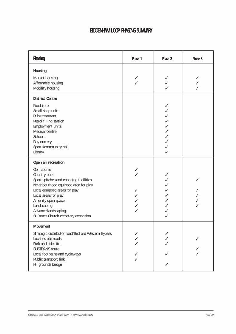
BIDDENHAM LOOP REVISED DEVELOPMENT BRIEF - ADOPTED JANUARY 2003 PAGE 39
BIDDENHAM LOOP PHASING SUMMARBIDDENHAM LOOP PHASING SUMMARBIDDENHAM LOOP PHASING SUMMARBIDDENHAM LOOP PHASING SUMMARBIDDENHAM LOOP PHASING SUMMARYYYYY
PhasingPhasingPhasingPhasingPhasing Phase 1Phase 1Phase 1Phase 1Phase 1 Phase 2Phase 2Phase 2Phase 2Phase 2 Phase 3Phase 3Phase 3Phase 3Phase 3
Housing
Market housing ✓ ✓ ✓
Affordable housing ✓ ✓ ✓
Mobility housing ✓ ✓
District Centre
Foodstore ✓
Small shop units ✓
Pub/restaurant ✓
Petrol filling station ✓
Employment units ✓
Medical centre ✓
Schools ✓
Day nursery ✓
Sports/community hall ✓
Library ✓
Open air recreation
Golf course ✓
Country park ✓ ✓
Sports pitches and changing facilities ✓ ✓
Neighbourhood equipped area for play ✓
Local equipped areas for play ✓ ✓ ✓
Local areas for play ✓ ✓ ✓
Amenity open space ✓ ✓ ✓
Landscaping ✓ ✓ ✓
Advance landscaping ✓ ✓
St James Church cemetery expansion ✓
Movement
Strategic distributor road/Bedford Western Bypass ✓ ✓
Local estate roads ✓ ✓ ✓
Park and ride site ✓ ✓
SUSTRANS route ✓
Local footpaths and cycleways ✓ ✓ ✓
Public transport link ✓
Hillgrounds bridge ✓

PAGE 40 BIDDENHAM LOOP REVISED DEVELOPMENT BRIEF - ADOPTED JANUARY 2003

BIDDENHAM LOOP REVISED DEVELOPMENT BRIEF - ADOPTED JANUARY 2003 PAGE 41
1. Ecologists have carried out a comprehensiveecological assessment of land lying within the loop ofthe River Great Ouse at Biddenham. The assessmentwas based on survey work carried out during March1991 and on information obtained from the followingrecognised sources:
The Nature Conservancy Council for England(English Nature),
Bedfordshire and Cambridgeshire Wildlife Trust,
Bedford Museum Biological Records Centre(BMBRC),
The British Trust for Ornithology.
2. The ecological assessment and sites ofecological significance are illustrated on Maps 2 and 3.
Designated Sites and Other Recorded Sites of InterestDesignated Sites and Other Recorded Sites of InterestDesignated Sites and Other Recorded Sites of InterestDesignated Sites and Other Recorded Sites of InterestDesignated Sites and Other Recorded Sites of Interest
3. The consultation draft Nature ConservationStrategy for Bedfordshire, published by English Natureand the County Council in October 1993, identifiesWildlife Priority Areas. These represent concentrationsof wildlife habitats and important biogeographicalfeatures where positive action will produce the mostsignificant benefits for wildlife. The River Great OuseValley is identified and thus the land in the BiddenhamLoop.
4. The River Great Ouse itself is designated as aCounty Wildlife Site (CWS) by the Beds and CambsWildlife Trust, in collaboration with English Nature. Thisis a non-statutory county level designation, applied tosites which are of greater than local significance, butwhich do not meet the criteria for national designationssuch as Sites of Special Scientific Interest (SSSI). TheCWS includes the section of the river known as theBiddenham Loop. Whilst the CWS is only notional (ie.there is no firmly defined boundary), it can be taken toinclude the pasture areas of the brief site, and all of theassociated ditches, as well as the old mill-site ponds(MP1, MP2). As these areas of nature conservationinterest are located around the periphery of the briefsite there need be no conflict with development whichis located away from the peripheral areas.
5. No other designated sites occur within the studyarea, statutory or otherwise.
6. The nearest statutorily designated site to thestudy area is the Biddenham Pit SSSI, which lies about0.5km away from the northern periphery. This SSSI isdesignated on geological grounds, but lies within anarea of woodland (Deep Spinney) identified in theBedford Borough Local Plan 1993 as being of localsignificance for nature conservation. The nearestbiological SSSI is Hanger Wood, which lies some 1kmaway from the western edge of the site.
7. County Wildlife Sites occur along and adjacentto the river running upstream (north) of the siteboundary, one of which includes the Bromham Parkheronry. Another CWS lies downstream of the studyarea, about 0.5km away from the easternmost corner. Inaddition, there are a number of sites identified in theLocal Plan as being of local ecological significance,lying to the west of the Biddenham Loop.
Ecological EvEcological EvEcological EvEcological EvEcological Evaluationaluationaluationaluationaluation
8. The main feature of ecological importance onthis site is the corridor of habitats associated with theRiver Great Ouse and its side-channel (SC1). Thiscorridor comprises the river and its banks, the pasturegrasslands (E1 - E8), the wooded areas W2, W3 andW3a, and all the associated ditches, hedges, trees andscrub. These include H1 and its associated ditch, hedgesH20, H21 and H23, the ditch D1 and the old mill-siteponds. Taken together, these features provide a complexand diverse system of riparian and floodplain habitats,supporting a wide range of plant species of particularvalue to birds and invertebrates.
9. The old mill-site ponds (MP1, MP2) are ofconsiderable ecological value in their own right,providing a sequence of integrated wetland habitats,and supporting a varied flora. These features are also ofparticular value to birds and invertebrates.
10. The remainder of the site appears to be oflimited ecological value, particularly the arable lands.The hedges of the northern periphery (H4 - H11) andnorth of Church End (H1 - H3, H24), and theirassociated standard trees are valuable habitatelements, as are the minor wooded areas such as theneglected orchard (O1) and the wooded area (W4), butelsewhere the ecological value is negligible. The only
Appendix 1 Ecology

PAGE 42 BIDDENHAM LOOP REVISED DEVELOPMENT BRIEF - ADOPTED JANUARY 2003
recorded ecological interest of the arable zone is theregular occurrence of one or two pairs of nestinggrasshopper warblers.
11. On the basis of this evaluation, it appears that theBiddenham Loop site contains no features which can besaid to be of national significance in terms of natureconservation. The individual elements of the river corridorare not in themselves of outstanding interest, but takentogether they form a system of habitats which qualify asbeing of a county level of significance. This is reflected inthe designation of the river as a County Wildlife Site. Theold mill-site ponds can be considered as forming part ofthis system, although they are important in themselves,being certainly of local significance.
12. The remaining hedges, standard trees, ditches,arable lands and minor wooded areas are of no morethan local significance, although the presence ofgrasshopper warblers is noted.
Ecological RecommendationsEcological RecommendationsEcological RecommendationsEcological RecommendationsEcological Recommendations
13. The river corridor areas and old mill-site pondsshould be retained with appropriate management as
part of any development proposals for this area. Thiscorridor should include the enclosures E1 - E8, woodedareas W2, W3 and W3a and associated hedges, treesand ditches. These areas should be retained so as toperpetuate the current situation, and could beenhanced by sensitive planting of selected areas withnative trees and shrubs, low-intensity agricultural useof the grasslands with minimal further improvement,and the creation of new wetland areas alongside theriver.
14. Elsewhere on the site, hedges and standard treesshould be retained wherever possible and enhanced byreplanting with native species. Appropriatemanagement regimes should be considered so as toincrease the current level of structural diversity.Additional areas of native broadleaved woodland wouldbe valuable.
15. Any development proposals should giveconsideration to the incorporation of new habitatswithin any open space or amenity areas. These couldinclude new areas of herb-rich grassland sward, newponds and wetlands. Consideration should be given tothe incorporation of small areas suitably designed foruse by grasshopper warblers.

BIDDENHAM LOOP REVISED DEVELOPMENT BRIEF - ADOPTED JANUARY 2003 PAGE 43
The ResearchThe ResearchThe ResearchThe ResearchThe Research
1. Three pieces of research have been carried out inorder that the archaeological importance of the areacould be examined.
2. The first was an archaeological1 brief preparedby Bedfordshire County Council Conservation andArchaeology Section in August 1990.
3. The second was a preliminary archaeologicalassessment by consultants - Countryside Planning andManagement - in March 1991. Both of theseinvestigations highlighted a potentially significantarchaeological dimension to any proposed developmentand recommended a detailed assessment of therecorded archaeology.
4. The third and most comprehensive piece ofresearch was completed in May 1991 and a copysupplied to the County Archaeologist. It had three mainobjectives in mind.
(a) The compilation of base-line archaeological datafrom the study area, covering all periods,presented as a written record withaccompanying plans. This includes cartographic,archaeological and documentary information.
(b) The assessment of the nature, extent andimportance of the archaeological resourcerepresented.
(c) The formulation of recommendations and optionsto deal with all aspects of the archaeology ofthe study area with an outline timetable forfurther work, liaison and consultation.
5. The report provides high quality archaeologicaldata with a view to enabling:
i. any modifications to the design, constructionmethods, and/or layout of the proposeddevelopment which might enhance theworthwhile preservation of archaeologicaldeposits to be made at the earliest opportunity;
ii. the design, planning and costing of the mostappropriate archaeological response to theproposed development to be prepared in goodtime; and
iii. detailed applications for planning permission tobe prepared in the light of firm archaeologicaldata.
Archaeological SummaryArchaeological SummaryArchaeological SummaryArchaeological SummaryArchaeological Summary
6. All main published and archive archaeologicaland historical sources were examined. Together, thiswork has revealed a number of areas of varyingarchaeological interest representing all thechronological periods.
7. Evidence for the Paleolithic period focuses on ascatter of artifacts from the mixed lithologies of semi-derived gravels which represent terrace deposits ofprobably Hoxnian date. Mesolithic evidence is sparseand restricted to isolated recorded stray finds. TheNeolithic is represented by one probable oval barrowand a single probable mortuary enclosure.
8. Bronze Age activity includes three probablebarrow groups and three sets of habitation fociinterpreted from flint scatters. The Iron Age materialincludes pottery from a cremation cemetery and a sub-circular enclosure which has been suggested as anoppida site (a centre of late Iron Age pre-Roman urbanactivity).
9. The Roman period is reflected in metal-detecting finds and includes a probable minor villa siteand rectilinear fragments of an aggregate field system.Anglo-Saxon finds are few but concentrated. Nomonuments of this date could be identified.
10. Mediaeval artifacts were sporadic and fivemonuments were described: a mill, fishponds, atrackway, a quarry and a warren. Components of theopen field system were also recognised together withthe site of a ford.
11. Finally for the post-mediaeval and early modernperiods, two ancillary farm buildings, a farmstead, twoquarries and a footbridge could be located. Most of thestudy area has been under arable cultivation andfeatures truncated.
Appendix 2 Archaeology
1 For the purposes of this brief ‘archaeology’ is taken to mean the study of past human societies through their material remains, from prehistoric timesto the modern era. No rigid upper date limit has been set but AD1900 is used as a general cut-off point.
PAGE 44 BIDDENHAM LOOP REVISED DEVELOPMENT BRIEF - ADOPTED JANUARY 2003
Archaeological RecommendationsArchaeological RecommendationsArchaeological RecommendationsArchaeological RecommendationsArchaeological Recommendations
12. In those areas where development is proposedwhich is likely to affect sensitive areas, furtherevaluation is desirable. In the first instance this shouldtake the form of field walking, field survey and limitedgeophysical sampling. Subject to the results of thiswork the next stage would take the form of trialtrenching and pitting. This would aim to identify anddate archaeological deposits and determine their degreeof survival.
13. Undertaking this work may lead to one of twoconclusions: either the sites are badly damaged andfurther excavation would add little or nothing to whatevaluation itself revealed, or that there are deposits ofinterest and value that would be worthy ofmanagement. In the latter case four main optionscould be explored: preservation in-situ, totalexcavation, partial excavation, and watching briefsduring groundworks. Given what is already known it islikely that a combination of these four options could beused.

BIDDENHAM LOOP REVISED DEVELOPMENT BRIEF - ADOPTED JANUARY 2003 PAGE 45
Appendix 3 Urban Design Objectives
The purpose of this appendix is to show how each ofthe urban design principles will be applied to the mainelements of the development. These are the districtcentre and the residential districts.
District CentreDistrict CentreDistrict CentreDistrict CentreDistrict Centre
The district centre should be developed in accordancewith the following design principles:
Character
The district centre provides the opportunity tocreate a form of mixed-use development based on atraditional high street. Building scale and landmarkfeatures should be used to reflect the importance ofthis area as the focus for community activities. Thedistrict centre will have a distinctly urban character.
It is essential that residential use is located abovethe shops in order to maximise surveillance andliveliness. The housing should also have directaccess to the public realm.
Narrow plot widths should be used to promote moreactive frontages, increase the sense of enclosureand allow for higher densities.
A public square should provide seating areas andparking areas and a more formal focus to thedistrict centre. The space should be overlooked bybuildings, but should also have tree planting toprovide a degree of enclosure and shade.
The use of local materials, building methods anddetails should be considered in order to enhancelocal distinctiveness.
Continuity and Enclosure
Development should be arranged in a series ofstreets and blocks and thus create a cleardistinction between public and private space.
The majority of the buildings should be linked,creating a sense of enclosure and continuity to themain street. Blocks should have a varied buildingline to create informal edges to streets and squares.There should be frequent variations in the angle ofbuildings and the building line with alternatingsections of enclosed street and incidental spaces toadd interest.
Buildings should both front the street, and thepublic square. These should be linked, with aminimum of blank walls and gaps between buildingsthus maximising liveliness and the extent to whichthe street is overlooked. Within the centre, buildingssuch as the school, community hall, supermarketand retail units should be fully integrated into theHigh Street frontage and should not ‘stand alone’ intheir own grounds.
The primary access to buildings should be from thestreet and building entrances should be easilyidentifiable.
Private space, including service areas should beenclosed by the backs of buildings.
Buildings and trees should be used to enclose publicspace and provide a strong sense of definition.
LowerSchool
Nursery
Fig EFig EFig EFig EFig E District CentreDistrict CentreDistrict CentreDistrict CentreDistrict Centre
PublicSquareCommunity
Hall
Housing
Local Shops
Supermarket

PAGE 46 BIDDENHAM LOOP REVISED DEVELOPMENT BRIEF - ADOPTED JANUARY 2003
Quality of the Public Realm
The district centre should include a new publicsquare that is well overlooked and is designed tosupport a wide range of activities. Spaces should bekept as small as possible to encourage liveliness anda sense of human scale. Parking areas should bebroken up into a series of small, well-landscapedclusters rather than in one large area. In order tokeep the size of the square as small as possible,parking should also be provided within the centre ofthe street blocks.
Building entrances should be at frequent intervalsso as to create activity.
The fronts of buildings should be orientated aroundthe main pedestrian flows to enhance security andvitality.
Works of art and well-designed street furnitureshould be used to create identity and enhance thesense of place. Extensive seating opportunitiesshould be incorporated into the design. Bins shouldalso be provided.
Street furniture should be co-ordinated in order toavoid clutter. Maintenance, resistance to vandalismand access to underground services should also beconsidered.
Account should be taken of microclimate includingsunlight and daylight, wind, temperature and frostpockets.
Ease of Movement
The district centre should be a major intersectionfor footpath, cycle and public transport networks.
Higher residential densities should be locatedaround the district centre so as to support greaterpublic transport use.
Legibility
Legibility should be enhanced by grouping largerscale community buildings (eg. school andcommunity centre) and using them to define publicspaces; through the use of landmarks, artworks,planting, seating areas, or architectural featuressuch as clocktowers; through careful orientation ofbuildings in terms of views and vistas and throughthe detailing of buildings, street furniture and hardlandscape materials.
Adaptability
Consideration should be given to floor to ceilingheights and building depths. These influence how
easy it is to convert a building to other uses. Itshould be recognised that the composition of thecentre is likely to change over time and this shouldbe facilitated in building design. The use of threestorey townhouses provides the potential for theground floor to be converted to other uses overtime.
Diversity
For the centre to be successful, it mustaccommodate a range of different community,commercial and residential units. This will support awide range of activities during the day and theevening. Residential or office uses will be expectedto exist above active shop or workshop frontages.
Residential DistrictsResidential DistrictsResidential DistrictsResidential DistrictsResidential Districts
Character
A variety of dwelling types, sizes and styles shouldbe provided to ensure that the varied needs of thecommunity are met and also that visual diversity isachieved.
The character of the residential districts shouldreflect the character of existing housing areaswithin Bedford, Kempston and Biddenham. It shouldreflect local building forms including distinct housingtypes, spatial relationships, boundary treatments,building lines, roof slopes, window types andgardens. These are set out in paragraphs 6.10 - 6.16.
Three distinct character areas have been identified.These are the urban character area whichencompasses the primary routes through the site,the semi-formal edge with the golf course and thesemi-rural character on the western and south-western edges.
The urban character area.Here it is appropriate to introduce some of the moreurban elements found in the traditional street andblend them with some of the semi-ruralcharacteristics of the lower density areas. This willaid legibility through the site and make it distinctfrom the other character areas. New developmentwill be expected to:
have a density of about 35 dwellings per hectare
range from 1½ to 2 and 2½ storeys high
be grouped into short terraces, creating a nearcontinuous built frontage
have the occasional building set back and atright angles to the road to create visual interest.

BIDDENHAM LOOP REVISED DEVELOPMENT BRIEF - ADOPTED JANUARY 2003 PAGE 47
restrict soft landscaping elements to trees liningthe street and in curtilage planting
restrict size of front gardens with the occasionalbuilding located at the back edge of the footway
create a clear distinction between public andprivate realm
define boundaries by means of low stone walls,hedges and the occasional section of railings
display a range of materials, including stone,brick, render, plain tile and pantile. (see Fig F)
The semi-formal character area.This will be expected to have the followingcharacteristics:
density of about 30 dwellings per hectare
semi detached and detached buildings
2 -2½ storeys high
a well defined building line
consistency in building type, materials andarchitectural style
modest front gardens enclosed by railings or lowwalls
more formal planting at the interface with thegolf course. (see Fig G)
The semi-rural character area.New development will be expected to:
have a density of about 30 dwellings per hectare
display an informal pattern of development toreflect and reinforce the strong rural character
display a variety of building forms
consist mainly of a collection of individualbuildings with the occasional short terrace
range from 1 to 2 storeys in height
have individual and clusters of dwellings in alandscape dominated environment set back fromthe road
have an ‘organic’ relationship to adjacentbuildings - this could involve setbacks, changesin frontage angle and variation in widthbetween buildings
create small informal areas of semi-public andpublic open space
Fig FFig FFig FFig FFig F Urban HousingUrban HousingUrban HousingUrban HousingUrban Housing
Occasionalbuilding set back
Use of hedging andlow walls to define boundaries
Private backs
Public fronts
Buildings frontonto the street

PAGE 48 BIDDENHAM LOOP REVISED DEVELOPMENT BRIEF - ADOPTED JANUARY 2003
have variety of front garden size and length
provide space for structural planting in publicspaces in the form of wide verges and greens,including stands of specimen trees. Useextensive informal planting on the fringe of thedevelopment to provide a soft edge to thecountry park.
define boundaries by low stone walls, hedges orpicket fences. Use soft verges with drives andfootways in loose or rolled gravel.
use a range of materials, including thatch, stone,render, brick, plain tile and pantile. (see Fig H)
Particular care will be needed to ensure a gradualtransition between these character areas. Thisshould be addressed in detailed design codes.
Traffic calming throughout the site must ensurethat safe, pleasant residential areas are created.
Recognise that every element in the street scenecontributes to the identity of a place includingsculpture, lighting, railings, litter bins, paving andstreet furniture. These should be considered as anintegral part of the design process.
Continuity and Enclosure
Development should be arranged in series of streetsand perimeter blocks and thus create a cleardistinction between public and private space.
Buildings should front onto the street and publicspace including the golf course and the country parkto enhance liveliness and community safety. Thiscan be achieved by the use of separate slip roadswhere access is restricted eg. where developmentfronts onto a main road or onto open space.
Private space should be enclosed by the backs ofbuildings. Rear gardens should back onto othergardens rather than roads, footpaths or serviceareas. This will make them more secure.
The primary access to buildings should be from thestreet.
Where courtyard development is used, access toparking courtyards should be controlled by means ofgates or by overlooking. This may necessitatelocating dwellings within the courtyard itself.
A limited palette of building materials, styles anddetailing should be used to provide continuity toany one residential district.
Within houses, position the less private rooms (suchas the living room) so as to face the street,especially at ground floor level.
Fig GFig GFig GFig GFig G Semi-fSemi-fSemi-fSemi-fSemi-formal Housingormal Housingormal Housingormal Housingormal Housing
Well defined building line
Formal plantingto edge
Golf Course

BIDDENHAM LOOP REVISED DEVELOPMENT BRIEF - ADOPTED JANUARY 2003 PAGE 49
Quality of the Public Realm
Streets and spaces should be overlooked so as tomaximise natural surveillance. This is particularlyimportant in the case of play areas, communalspace and parking areas.
Public space within residential areas should include,footpath and cycleway corridors as well as largergreen open spaces. Equipped areas of play should beaccommodated within the larger open spaces,together with informal recreation facilities. Thereshould be extensive seating opportunities andseating must be provided adjacent to the equippedplay areas.
Works of art and well designed, high quality,durable street furniture and surfacing materialsshould be provided to create identity and enhancethe sense of place. This should be co-ordinated inorder to avoid clutter. Maintenance, resistance tovandalism and access to underground servicesshould also be considered.
Ease of Movement
The layout of housing areas should maximiseaccessibility to public transport. In general, vehicles,
pedestrians and cyclists should share the samemovement corridor rather than be geographicallysegregated.
All dwellings should be within 400m of a bus stop.
Movement routes should be overlooked by residentialproperties or community buildings and should be litas necessary so that they are safe and secure.
Legibility
Use prominent buildings to enhance legibility.Consider how detailing of boundary treatments,surfaces, building materials, windows, and doorsetc, can be used to make the areas more legible.
Adaptability
House types that allow homeworking and life-timeoccupation should be provided.
Consideration should be given to floor to ceilingheights and building depths. These influence howeasy it is to convert a building to other uses.
Public spaces should be designed to support a rangeof different uses and activities.
Diversity
To promote social inclusion, social housing shouldbe fully integrated into the development.
Fig HFig HFig HFig HFig H Semi-rural HousingSemi-rural HousingSemi-rural HousingSemi-rural HousingSemi-rural Housing
Country Park/Green Wedge
Wide landscape margins and useof softer edges/gravel surfaces
Extensive use of trees, shrubs and hedgingto create a landscape dominated streetscene
Occasional buildingon the back ofpavement
Variety offront garden depths
Use of gable endsonto the street
Limestone rubble wallsdefine front boundaries

PAGE 50 BIDDENHAM LOOP REVISED DEVELOPMENT BRIEF - ADOPTED JANUARY 2003

BIDDENHAM LOOP REVISED DEVELOPMENT BRIEF - ADOPTED JANUARY 2003 PAGE 51
Appendix 4 Local Plan Policies
The following Bedford Borough Local Plan Policies relate to the area covered by this Brief.
Policy BE42 LightingPolicy BE43 Public spacesPolicy BE44 Public artPolicy BE45 Community safetyPolicy BE48 Accessible environmentsPolicy BE49 Accessible environments
HousingHousingHousingHousingHousingPolicy H31 The provision of affordable housingPolicy H32 Housing type and sizesPolicy H34 Mobility Housing
EmploEmploEmploEmploEmploymentymentymentymentymentPolicy E14 Working from home
ShoppingShoppingShoppingShoppingShoppingPolicy SH7 New local shopping facilities
TTTTTransportransportransportransportransportPolicy T1 Strategic road networkPolicy T4 Highway impactPolicy T6 Public transport infrastructurePolicy T7 Developer contributionsPolicy T13 Pedestrian routesPolicy T14 Cycle routesPolicy T15 ParkingPolicy T17 Park and ride facilitiesPolicy T20 Safety and traffic calmingPolicy T21 Accessibility for the disabled
Leisure & RecreationLeisure & RecreationLeisure & RecreationLeisure & RecreationLeisure & RecreationPolicy LR7 Use of river Great OusePolicy LR9 MooringsPolicy LR10 Access to countrysidePolicy LR15 Outdoor playing space for sportPolicy LR16 Children’s play spacePolicy LR17 Amenity open spacePolicy LR19 Community facilities
UtilitiesUtilitiesUtilitiesUtilitiesUtilitiesPolicy U2 FloodplainPolicy U3 Waste water
SSSSStrategytrategytrategytrategytrategyPolicy S3 Urban area boundaryPolicy S8 Supplementary guidancePolicy S9 Community and other facilities
Natural EnvironmentNatural EnvironmentNatural EnvironmentNatural EnvironmentNatural EnvironmentPolicy NE1 Sites of special scientific interestPolicy NE2 Environmental lossesPolicy NE3 County wildlife sitesPolicy NE4 Trees and hedgesPolicy NE8 Natural historyPolicy NE12 Retention of landscape featuresPolicy NE13 Safeguarding and future
management of landscape featuresPolicy NE15 River Protection AreaPolicy NE16 FloodingPolicy NE17 Urban open spacePolicy NE20 Landscape and environmental
improvementPolicy NE24 Protection and enhancement of water
resources
Built EnvironmentBuilt EnvironmentBuilt EnvironmentBuilt EnvironmentBuilt EnvironmentPolicy BE3 Self-sustaining communitiesPolicy BE5 Area of Special RestraintPolicy BE8 Energy efficient layoutsPolicy BE11 Setting of conservation areasPolicy BE23 ArchaeologyPolicy BE24 ArchaeologyPolicy BE25 ArchaeologyPolicy BE29 High standard of designPolicy BE30 Material considerationsPolicy BE31 Statement of design principlesPolicy BE32 Development on the edge of urban
areasPolicy BE34 Development adjoining main road
and rail routesPolicy BE35 Achieving quality in residential
layoutsPolicy BE38 LandscapingPolicy BE39 LandscapingPolicy BE40 Landscaping
POLICY POLICY

Biddenham Loop
Scale in metres
0 250 500
Map 1 Brief Area & Constraints
This map is reproduced from Ordnance Survey material with the permission of Ordnance Survey on behalf of the Controller of Her Majesty’s Stationery Office.
Crown copyright. Unauthorised reproduction infringes Crown copyright and may lead to prosecution or civil proceedings. Bedford Borough Council Licence No. LA 077127. 01/2003
©
Brief Area Boundary
Area of Special Restraint
River Protection Area
Land liable to Flood
Proposed route ofA6/A428/A421 link
Existing built-up area
Electricity Power Line
Footpath

Bromham BridgeBromham Bridge
Old mill-sitepond system
Corn bunting roost site
Large rabbit warren -possible old badger sett
Arable Zone -Grasshopper warblernests locally
Planted appletrees present
Reed warbler -foraging and nestinghabitat. Possiblekingfisher site
Hedge with nationallyrare plant (greaterdodder) present
Side-channel
H1H1
H2H2
T1T1
E1E1
E2E2
E3E3
E4E4
E4E4
H4H4
H5H5
H7H7
H8H8
T5T5
W4W4
H10H10
H11H11
H12H12
H13H13
H14H14
H16H16
H17H17
H15H15
W3W3
H18H18
H19H19
D1D1
D3D3
D1D1
D2D2
E6E6
SC1SC1
SC1SC1 H21H21
H21H21
H22H22
W2W2
W2W2
H22H22
E5E5
E5E5
H20H20
E8E8
E7E7
H20H20
F1F1
Tr1Tr1
T4T4 W5W5H9H9H6H6
O1O1
H23H23
H24H24
H23H23
Tr2
T3T3
MP1MP1
MP2MP2
E3E3
H3H3
W1W1
H24H24
Qr/FeQr/Fe
Fe/Ap/AgFe/Ap/Ag
Sx/QrSx/QrSxSx
FeFeQrQrQrQr
SxSx
PavPavFeFe
Fe/ApFe/Ap Fs/PsylFs/Psyl
QrQr
QrQr
QrQrSxpSxp
SxpSxp
SxpSxp
SxpSxp
Fe/Ag/CmFe/Ag/Cm
Cm/FeCm/Fe
SxpSxp
Ar
Ar
Ar
Ar
Ar
Ar
Ar
Ar Ar
Ar
Ar
Ar
Ar
Ar
Ar
Ar
Ar
Ar
Ar Ar
Ar
Ar
Ar
Ar
ArAr
Ar
SxpSxp
SxpSxp
SPECIESSx Willow (Salix)Sxp Willow pollard
SPECIESSxSxp Willow pollard
Willow (Salix)Fe Ash (Fraxinus excelsior)Ag Alder (Alnus glutinosa)Qr Oak (Quercus robur)
Fe Ash (Fraxinus excelsior)Ag Alder (Alnus glutinosa)Qr Oak (Quercus robur)
Ap Sycamore (Acer pseudoplatanus)Cm Hawthorn (Crataegus monogyna)Pav Cherry (Prunus avium)
Ap Sycamore (Acer pseudoplatanus)Cm Hawthorn (Crataegus monogyna)Pav Cherry (Prunus avium)
SxpSxp
SxpSxp
SxpSxp
SxpSxp
SxSx
SxpSxp
SxpSxp
SxpSxp
SxpSxp
SxpSxp
SxpSxp
SxpSxp
SxpSxp
SxpSxp
Qr/CmQr/Cm
SxpSxp
SxpSxp
JrJr
Sx/Fe/CmSx/Fe/Cm
Fe/Qr/AgFe/Qr/Ag
Fe/Qr/AgFe/Qr/Ag
Fe/Qr/AgFe/Qr/Ag
Ag
SxpSxp
Fe/ApFe/Ap
SxpSxp
SxSx
SxSx
Fe/Sx/CmFe/Sx/Cm
Fe/Sx/CmFe/Sx/Cm
SxSx
SxSxSxSx
Ag
Psyl Scots Pine (Pinus sylvestris)Jr Walnut (Juglans regia)Psyl Scots Pine (Pinus sylvestris)Jr Walnut (Juglans regia)
XX X X X X X X
XX
X
XXX
X
X
X
X
X
X
XX
X
X
X
X
X
X
X
X
X
X
X
X
X
X
X
X
X
X
X
X
X
X
X
X
X
X
X
X
X
XX
X
X
X
X
X
X
XX
X
X X
XX XX
X
X
X
X
XX
XX
X
X
X
X
X
X
X
X
XX
X
X
X
XX
X
X
X
X
X
XX
X
XX XX
X
X
X
X
XX
X
XX
XX X
XXXXX
X
X
X X
X
X
X
Biddenham Loop
Scale in metres
0 250 500
Map 2 Ecological Appraisal(1991)
Woodland and scrub communities
Orchard
Scattered scrub/Tree groups
Rough Grassland -tracks/headlands etc
Improved permanentpasture grassland
Area affected by the layingof the South Orbital Sewer -topsoil stripped (March 1991)
Open Water -river/ponds/ditches etc
Seasonal wetland
Arable lands
Hedge, with ref no.(see report)
Relict hedge, with ref no.(see report)
Standard trees - approx position only
Fence
Reference codes (see report)
H1H1
H2H2
E1 F1 W1
MP1 SC1 H1
Ar
X
X
X
This map is reproduced from Ordnance Survey material with the permission of Ordnance Survey on behalf of the Controller of Her Majesty’s Stationery Office. Crown copyright.Unauthorised reproduction infringes Crown copyright and may lead to prosecution or civil proceedings. Bedford Borough Council Licence No. LA 077127. 01/2003
©

Biddenham Loop
Map 3 Ecological Assessment (1991)
Scale 1 : 50,000
Study Area
Site of Special Scientific Interest (SSSI)
County Wildlife Site
River Corridor Prime Site (approx)
Site of Local Ecological Significance

��
����
��
Biddenham Loop
Map 4 Illustrative Master Plan
Scale in metres
0 150 300
This map is reproduced from Ordnance Survey material with the permission of Ordnance Survey on behalf of the Controller of Her Majesty’s Stationery Office. Crown copyright. Unauthorised reproduction infringes Crowncopyright and may lead to prosecution or civil proceedings. Bedford Borough Council Licence No. LA 077127. 01/2003
©
Road
Squares
Park & Ride / Bus Route
Other Bus Route
Playing Fields
NEAP -
LEAP -
Trees and Hedges (existing and proposed)
Housing
Landmark Buildings
Agriculture
Key Frontages
Balancing Pond
Community Uses:
Nursery
Supermarket
Local Shops
Offices
Ecumenical Centre
Community Hall
Public House
Workshops
Changing Rooms
N
S
L
O
E
C
P
W*
CR
Neighbourhood Equipped Area for Play
Local Equipped Area for Play
(inc recycling facility)
To newriver crossing
Cycleway / Footpath
Footpath
Open Space
National Cycle Network route 51/footpath
��
��
Park & Ride
MiddleSchool
LowerSchool
C
Site forMedicalFacility
SL
EO
PW*
CRCR
N
This master plan is indicative and does not imply that every element of the grid has to be a through route. It is recognised that the need for good access has to be balanced with the needs of community safety, as detailed in section 5.8 of Achieving Quality in ResidentialLayouts. Please also refer to paras. 4.18, 6.21 and 6.26 of the development brief text.

Biddenham Loop
Map 5 Housing Density
This map is reproduced from Ordnance Survey material with the permission of Ordnance Survey on behalf of the Controller of Her Majesty’s Stationery Office. Crown copyright. Unauthorised reproduction infringes Crown copyright and may lead to prosecution or civil proceedings. Bedford Borough Council Licence No. LA 077127. 01/2003©
High Density Housing
Medium Density Housing
Low Density HousingScale in metres
0 150 300