guiding spatial changes: singapore urban planning...
TRANSCRIPT
For 4th Urban Research Symposium 2007 Urban Land Use and Land Markets
The World Bank, Washington, DC, 14-16 May 2007
26
GUIDING SPATIAL CHANGES: SINGAPORE URBAN PLANNING
Dr Belinda Yuen
National University of Singapore 4 Architecture Drive, Room SDE2-03-08
Singapore 117566 Email: [email protected]
Fax: +65-6300 1938 Summary. This paper is about land use planning and management in Singapore, which in recent years has increasingly gained international recognition as a good practice for public land management. Attention is to examine the development planning and development control processes in Singapore, and discuss how urban planners are using the British development planning legacy to build better and more sustainable places for people. The paper will analyze the institutional framework, legislative basis, development objectives, plans and policy instruments, performance and contradictions of the Singapore development planning and control system. Singapore presents a typical prototype of urban governance where land use planning is taken seriously, and plans are implemented with relatively high levels of compliance with development control and planning regulations. Keywords: development planning, development control, plan implementation, Singapore
1. INTRODUCTION
Singapore has often been described as a highly planned city-state. It is a city where land development is planned and strictly controlled. With few exceptions, all development involving construction or change of use requires permission. Despite criticisms of its centralized planning and tabula rasa development outcome (Koolhaas and Mau, 1995), Singapore presents a typical prototype of urban governance where land use planning is taken seriously, and plans are implemented with relatively high levels of compliance with development control and planning regulations. In recent years, Singapore has increasingly gained international recognition as a good practice for public land management (Yeung, 1987; Wakeley and You, 2001).
Singapore with a land area of 690 sq km is located just 1° north of the equator in the sub-region of South-east Asia. It has a present population of 4.5 million with projection to 6.5 million under its long-term development plan. Singapore is at the same time a city as well as a country with the city centre occupying an area of about 110 sq km in the southern part of the main island.
For 4th Urban Research Symposium 2007 Urban Land Use and Land Markets
The World Bank, Washington, DC, 14-16 May 2007
Guiding spatial changes: Singapore urban planning
2
Urbanization of the city-state however has progressed to such an extent that the whole island is classified as urban (Motha and Yuen, 1999). Needless to say, its planning system would have to take these operative factors on board as within the limited land area, the needs of the growing population, the city and the nation would have to be addressed.
While Singapore can trace its origins to earlier centuries, the form of its modern development and planning largely stems from its founding in 1819 as a British trading post of the East India Company1. Comprehensive planning and development control in Singapore started simultaneously during British colonial administration in 1959 with the enactment of the Planning Ordinance, which introduced the British notions of development plan and development control. Control over land allocation and the building thereon was considered important for several reasons. The first reason concerns matters of law and order given the multi-ethnic, multi-language, multi-religion nature of Singapore’s immigrant population. Separate housing areas were identified for the different ethnic communities of settlers: the Europeans, Bugis, Arabs, Chinese, Indians and Malays. In allocating land, first preference would be given to merchants, second to artisans and third to farmers. The second reason pertains to the island’s geographical constraints of limited land area, which promoted the need for the government to control the use of such space, and to arbitrate between competing uses. The third reason is the rising value of land to the new land and property owners, and their wish to do with it as they liked. The situation led to competing areas of self-interest between property owners and businesses, and the resultant need to protect collective community interest. It is precisely because of such interests that modern town planning has evolved as a particular set of administrative arrangements, and procedures for the control of development and use of land (Ashworth, 1954).
Nowhere is this perhaps more evident than in the British planning system with its key elements of development plan and development control. The 1947 Town and Country Planning Act, which introduced these aspects has established for the first time in England a comprehensive and compulsory planning system that covered the whole country, and sought to relate land use and development matters to national and regional policy, and define a major role for the public sector in urban development with regulatory powers and control over land use. Many of those planning ideas are transported to British colonies where they continue in urban planning practice, making the British planning system a common tool of managing the urban environment in many post-British colonial cities. As Healey (1988, p397) states,
The British planning system was once considered the most advanced in the world, in terms of both its legislation and its practice.
However, increasingly, too, various studies within Britain have generated debates regarding the effectiveness of the planning system, and development control in
1 Singapore was granted self-rule status from Britain in 1959. It then joined the Federation of Malaysia in 1963 and became independent in 1965.
For 4th Urban Research Symposium 2007 Urban Land Use and Land Markets
The World Bank, Washington, DC, 14-16 May 2007
Guiding spatial changes: Singapore urban planning
3
particular, for contemporary challenges (McLoughlin, 1973; Healey et al., 1985; Booth, 2002).
In post-independence Singapore, the pace and priority of development has changed dramatically. Under a program of deliberate intervention by the state or what McGee (1976) calls ‘deliberate urbanization’, an entire new townscape of high-rise, high-density buildings has all but replaced the low-rise, predominantly shop house colonial city of British rule. The new government (which has continued to govern Singapore from independence to the present time) has chosen an overtly interventionist approach towards urban development, adopting a strategy of integrating social, economic, political and spatial visions through the overarching process of planning, and legitimizing its control through performance in the provision of public goods. A good example is housing. Some 84% of Singapore’s resident population are housed in public housing with many continually registering residential satisfaction (Wong and Yeh, 1985; Yuen, 2005). The intervention is justified at both the ideological and pragmatic levels by a central concern over the survival of an independent island nation. Chan (1971) has argued that survival has been the structuring and rationalizing force for the policies by which Singapore is governed since self-government in 1959.
At the time of independence, Singapore had to respond to a severe socio-economic crisis, given the high unemployment (over 13%), high population growth (about 4%), housing shortage and overcrowding (about 250,000 people were living in degenerated slums and another 300,000 in squatter areas), labor strikes (the unions had strong communist influence), civil riots (among different ethnic groups of the population). Such instances appear to substantiate Castells (1981) argument that planning is a process of political intervention in the economic sphere so as to help preserve social stability. The overriding goal is for domestic and political stability, which is seen as the necessary foundation for strong economic growth and the institution of highly centralized planning machinery. Admittedly, the small size of Singapore, and the presence of a strong government have facilitated centralized planning without it being hampered by provincial authorities or sectoral interests.
The highest level of central decision-making in Singapore is the Cabinet developed from the British parliamentary model (Lim, 2000). Planning and development control are administered through a central planning agency, the Urban Redevelopment Authority (URA)2, a statutory board which comes under the portfolio of the Minister for National Development3. The Minister for National
2 This arrangement has existed since 1989. Prior to 1989, development control and planning were the functions of different government departments. For more detailed discussion, see Motha and Yuen (1999). 3 The statutory boards under the Ministry of National Development include the Building and Construction Authority (building control), Housing and Development Board (public housing), National Parks Board (public parks), Urban Redevelopment Authority. Since independence, government activities including local government activities are carried out by government departments organised under ministries or by statutory boards characterised by their functions, each with its own specific terms of reference. Each statutory board is empowered with enabling legislation to implement its programmes. The statutory boards are not a part of the civil service though each is responsible to an appropriate minister who in turn answers to the Cabinet. See Lim (2000).
For 4th Urban Research Symposium 2007 Urban Land Use and Land Markets
The World Bank, Washington, DC, 14-16 May 2007
Guiding spatial changes: Singapore urban planning
4
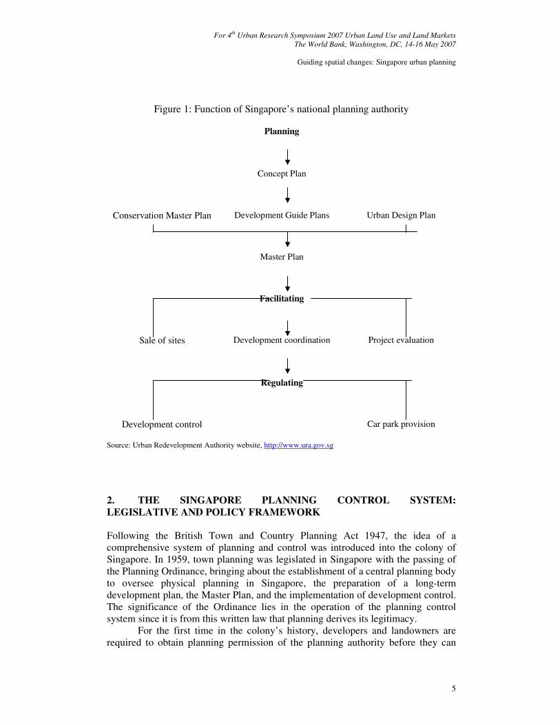
Development is currently the minister in charge of physical planning in Singapore. The Minister is the final authority in planning and development control matters. The day-to-day administration of physical planning and improvement of Singapore rests with the Urban Redevelopment Authority. The functions of URA, as illustrated in Figure 1, include to:
• prepare and revise development plans;
• control land use and development;
• provide good urban form;
• implement conservation; and
• coordinate public and private sector development proposals. Driven by a common vision of Singapore’s continued development, coordination among public development agencies is facilitated by various standing and working committees, which meet continuously to coordinate the formulation and implementation of their development policies. Inter-agency committees are formed and entrusted with specific roles in coordinating different land requirements (e.g. for meeting housing, industry, commerce, transportation, environment, and recreation needs), resolving land use conflicts (e.g. Master Plan Committee), or staying the course of design excellence. In recent years, the planning authority has set up advisory design panels comprising both public and private sector representatives to evaluate and formulate urban design guidelines in specific areas (e.g. architectural design, waterbodies, conservation) to promote stronger appreciation and aesthetics of a good urban environment. Put simply, as demonstrated within urban planning discourses, concern for the well ordered, beautiful city makes for an inclusive process (Healey, 2005; Smith, 2007). To ensure that plans remain relevant, workable and well integrated with the environment and infrastructure, the Urban Redevelopment Authority explicitly has sought to work with all relevant public development agencies when preparing and reviewing the Concept Plan and Master Plan. Its Development Control Division holds frequent dialogues with professional bodies and private sector to review development rules and guidelines to facilitate the work of the development industry. In other words, Singapore offers a case analysis of a single, central land use planning authority that handles every aspect of planning from strategic long-term planning to day-to-day development control.
For 4th Urban Research Symposium 2007 Urban Land Use and Land Markets
The World Bank, Washington, DC, 14-16 May 2007
Guiding spatial changes: Singapore urban planning
5
Figure 1: Function of Singapore’s national planning authority
Planning
Concept Plan
Conservation Master Plan Development Guide Plans
Urban Design Plan
Master Plan
Facilitating
Sale of sites
Development coordination Project evaluation
Regulating
Development control
Car park provision
Source: Urban Redevelopment Authority website, http://www.ura.gov.sg
2. THE SINGAPORE PLANNING CONTROL SYSTEM:
LEGISLATIVE AND POLICY FRAMEWORK Following the British Town and Country Planning Act 1947, the idea of a comprehensive system of planning and control was introduced into the colony of Singapore. In 1959, town planning was legislated in Singapore with the passing of the Planning Ordinance, bringing about the establishment of a central planning body to oversee physical planning in Singapore, the preparation of a long-term development plan, the Master Plan, and the implementation of development control. The significance of the Ordinance lies in the operation of the planning control system since it is from this written law that planning derives its legitimacy.
For the first time in the colony’s history, developers and landowners are required to obtain planning permission of the planning authority before they can
For 4th Urban Research Symposium 2007 Urban Land Use and Land Markets
The World Bank, Washington, DC, 14-16 May 2007
Guiding spatial changes: Singapore urban planning
6
develop any land. Prior to 1959, there was practically no legal control over development of land in Singapore. Only by-law planning and some ad hoc planning controls had existed, and these were largely related to construction control and public health4. With the preparation and subsequent approval of the first Master Plan by the colonial government, the traditional British planning concept of ‘survey-analysis-plan’ was also underway in Singapore. Thus, as with the British planning system, the Singapore planning system strengthened by its centralist notion of administration is to have two separate yet inter-related aspects of planning practice: development plan and development control.
Development Control
Development of land in Singapore is subject to statutory control. The statutory basis of this control is first set out in the 1959 Planning Ordinance, and now contained in the Planning Act Cap 232 (1998 Rev. Ed). Despite several amendments and revisions to the Planning Act over the past decades, the basis of development control has remained the same: no person shall without planning permission carry out any development of any land. This requirement has become a public institution of land use control in Singapore (Revised Master Plan, Report of Survey, Singapore, Ministry of National Development, 1980, p40):
Development control is...an essential part of building and programming for development.
Much of Singapore’s current built environment has been constructed under the aegis of the system of development control started in 1959. The key to this control lies primarily in the definition of development, which requires planning permission. The current legislation repeats the original 1959 definition, which is in pari materia with that contained in the British 1947 Act. Section 3(1) of the Planning Act Cap 232 defines development as:
...the carrying out of any building, engineering, mining, earthworks [the last word was not in the 1959 definition] or other operations in, on, over or under land, or to the making of any material change in the use of any building or land…
In other words, the notion of development is confined to the use and development of land; it is a process of change from one state of the built environment or the use of land to an alternative state. Planning permission, however, does not confer building approval. Building approval has to be obtained separately with the Building and Construction Authority.
As with the British planning system, there is, however, one problem with the above definition of development control. It is, as frequently acknowledged in British planning law literature, very wide and all-embracing, bringing within control
4 See Motha and Yuen (1999) Chp 6 for an account of the system prior to 1959.
For 4th Urban Research Symposium 2007 Urban Land Use and Land Markets
The World Bank, Washington, DC, 14-16 May 2007
Guiding spatial changes: Singapore urban planning
7
potentially all aspects of the use and development of land and buildings from the very small extension to a building to an insignificant change of use (Telling, 1986; Denyer-Green, 1987). As a result, this would give rise to a lot of work for the planners, but more importantly, it may not be totally workable in practice. Thus, the strategy has been to follow the British practice to provide for a number of exemptions from the definition: a category of development for which planning permission is ‘deemed’ to be granted by procedures other than those for development control, and a category of ‘permitted’ development, which while legally constituting development do not require planning permission5.
Several of those exemptions are set out in subsidiary legislation, for example, the Planning (Use Classes) Rules first introduced in 1960, and the Planning (Development of Land Authorization) Notification passed in 1963. These rules are statutory instruments which are provided for in the Planning Act, and can be amended relatively easily by the Minister. Over the years, the system of control has become increasingly sophisticated. For example, in 1964, development charge and a time limit on the grant of planning permission were introduced; in 1989 with the focus on conservation, a special type of control: conservation permission was introduced; in that year too, provisional permission was introduced to facilitate the development process (Khublall and Yuen, 1991; Motha and Yuen, 1999). Notwithstanding the changes, the system has not been fundamentally altered. It operates primarily, as under the British system, by:
• creating a wide definition in principle;
• extending or limiting that definition in specific cases; and
• varying the circumstances in which planning permission may be required.
By requiring planning permission to be obtained for all development, the 1959 legislation like its origins in the 1947 British planning act effectively nationalized an individual’s property development rights in Singapore. From 1959, it was to be the state that would decide when and where development and land use change would take place on the island by either allowing or withholding individual permissions tampered only by the willingness or otherwise of the private developer to invest in particular locations when demanded.
Development Plan
In exercising development control, the planning authority is required to have regard to the contents of the development plan. Similarly, development agencies, private and public, must have regard to the development plans in their preparation of planning application. The role of the development plan deserves closer examination since the two (development plan and development control) are inter-related. While the development plan allocates land uses, development control is the executive arm of the planning process that gives effect to the planning objectives of the
5 For details of these categories, see Planning Act Cap 232, Part III; Khublall and Yuen (1991).

For 4th Urban Research Symposium 2007 Urban Land Use and Land Markets
The World Bank, Washington, DC, 14-16 May 2007
Guiding spatial changes: Singapore urban planning
8
development plan. Those objectives are first set out in the Master Plan approved by the colonial government in 1958. The Master Plan is the first comprehensive development plan for the whole island of Singapore. It is a statutory plan governing the use of land for a period of 20 years with provision for 5-yearly reviews, which have to be approved by the Minister after an opportunity for objections from anyone affected by it.
Following closely the British development plans of 1947, the 1958 Master Plan was detailed and precise. It included a compendium of survey data on population, land use, traffic, employment and possible industrial development, maps showing the land use zones, and a written statement, which defined and gave guidance on how land uses are controlled by the zoning categories and intensities of development. Its objectives were basically to promote an overall orderly physical development of Singapore, provide a general framework of proposed land uses to guide future development, and ensure the optimal usage of land. It introduced two new concepts in the control of land use:
• the regulation of land use through zoning, and the control of intensity of development through density (for residential use) and plot ratio (for non-residential use); and
• the British planning ideas of new town and urban containment. The core policy of development set out in the 1958 Master Plan was essentially one of decentralization with a proposed green belt to arrest continued expansion of the city area, and the accommodation of further growth in three new towns outside the existing city.
Even though changes in the plan could be made through a legal process of public advertisement and inquiry, the 1958 Master Plan with its detailed and rigid land use zoning proposals proved incapable of dealing with the rapid post-independence urban changes and development during the 1960s. The new state government’s many large-scale development programs (such as housing and industrial development) required departures from the density and locational standards stipulated in the Master Plan. This led to the lifting of Master Plan controls on public sector development, and the search for a more responsive instrument to facilitate long-term planning.
The culmination of the process was a change in planning approach and strategies, moving from a conceptualization born of the British 1947 style of development plans to the new action planning of the Singapore Concept Plan. Public sector development was henceforth coordinated through the standing committee, Master Plan Committee, chaired by Chief Planner and comprising representatives from all relevant government agencies. The object of having representation from all relevant agencies is to ensure that land claims can be resolved without much delay and development projects expedited. The committee is tasked to consider and co-ordinate public department proposals, and resolve conflicts and land uses among the public agencies. The general aim is to ensure that state land is optimally and compatibly used according to the Concept Plan. The land
For 4th Urban Research Symposium 2007 Urban Land Use and Land Markets
The World Bank, Washington, DC, 14-16 May 2007
Guiding spatial changes: Singapore urban planning
9
recommendation of the Master Plan Committee when approved by the Minister is safeguarded for a development period of two years6.
The Concept Plan first adopted by the Singapore government in 1971 is a non-statutory plan that shows in structural terms the distribution and relationship between major land uses and transportation. A multi-nuclei spatial pattern of major development corridors supported by extensive road and rail networks is envisaged. The plan reinforces the view of comprehensive integrated planning. Unlike the Master Plan which concern is over the production of the plan, the focus of the Concept Plan is on the process of meeting its objective functions of being flexible, and responsive to the needs of all sectors. It overcomes the restrictions of the 1958 Master Plan by remaining an expression of principles and policies, not detailed proposals and land use maps. It is an evolving document in order to effect the strategic shifts necessary to meet growing needs, changing circumstances and available opportunities as they arise. On a 10-year planning cycle, the latest release of the Concept Plan in 2001 has built upon the earlier plans to unfold a vision of Singapore as a ‘dynamic, distinctive and delightful city’ in an increasingly globalizing world. Emphasis is not just on land optimization but also planning for a dynamic growth situation, taking a broader view of what society needs through planning, and delivering sustained development and a high quality of life for all. Once the basic needs are satisfied, strategies are laid on to enhance quality and distinction. The key strategies of the 2001 Concept Plan include7:
• creating a more livable city: provide a wider choice of housing types and locations and raise the quality of our living environment;
• creating a fun and exciting city: provide a wider choice of facilities, places and greenery for all to enjoy;
• creating an economically vibrant city: provide greater flexibility for businesses, and further improve transportation and connectivity;
• creating a distinctive city: focus on identity, to retain and enhance a sense of place identity.
With the widening frames of globalization and criticisms of tabula rasa
development additional attention is given to greenery, place identity and heritage conservation,
Buildings and places are part of Singapore’s built heritage. They are an important element in identity. To date, more than 5600 buildings have been conserved. In future, more buildings will be conserved to preserve the
6 Once approval is granted, the next step is for the relevant development agency to implement its proposed development as approved by the Minister. This will usually involve the acquisition of the land by the government if it is in private ownership, or in the case of state land, steps will be taken to vest it in the relevant development agency. See Khublall and Yuen (1991) and Motha and Yuen (1999) for further discussion of Singapore’s land acquisition act. 7 For more details of the proposals in the Concept Plan 2001, see Urban Redevelopment Authority (2001).
For 4th Urban Research Symposium 2007 Urban Land Use and Land Markets
The World Bank, Washington, DC, 14-16 May 2007
Guiding spatial changes: Singapore urban planning
10
character and collective memory of places. (Urban Redevelopment Authority, 2001, p42) To adequately understand and uncover places that are valued and have
identity planners have turned to the community with renewed impetus in the plan-making process. The logic is simple. As the Minister for National Development states,
All of us who have a stake here ought to have a say in how we want this place to develop. The more we are involved in the planning, then the more aware we are of the constraints we face and the trade-offs we need to make this little red dot [Singapore] liveable and comfortable. (The Straits Times, 21 Jul 2001)
Besides inputs from various government agencies, extensive public consultation through multiple channels (the media, focus group discussions, public dialogues, forum, exhibition, competition, etc) has been initiated to engage all sectors of the community (Urban Redevelopment Authority, 2001; Yuen, 2006). The planning outcome, as summarized by a focus group member,
The process of public participation is unparalleled. The URA has taken a back seat to let the public discuss. It did not impose or insist on things, but listened and made all the logistics possible for us to interview and discuss with various authorities, so this Concept Plan comes with a very good cross-sectional view. (The Sunday Times, 29 April 2001) In parallel with the Concept Plan, the Master Plan is being revised to
implement place-based planning. The community is again invited to work together with the planners in the plan-making process to define place identity and conservation areas at the more localized level. A key goal is consensus-building to create and foster a greater sense of community. As the Minister of State (National Development) states,
As conservation has gained recognition and success over the years, it is now timely for the planners to work with the public to further develop these efforts towards a Singapore where there is a sense of place, where identity is retained and our built heritage is enhanced. Our planners would like to seed some preliminary ideas in the Identity Plan exhibited to get a discussion started. I would like to stress that this is by no means the final nor the only direction to go. With your feedback and suggestions, the planners hope to arrive at a shared vision through this collaborative effort with the public. We have approached the making of the Identity Plan differently from the usual way of making plans. Instead of pre-determining how a place should shape up according to our plans, we are now looking at how our plans can enhance what is already on the ground and what people already find charming and
For 4th Urban Research Symposium 2007 Urban Land Use and Land Markets
The World Bank, Washington, DC, 14-16 May 2007
Guiding spatial changes: Singapore urban planning
11
appealing. (speech at the opening of the parks and waterbodies plan and identity plan exhibition, 23 Jul 2002, 5pm)
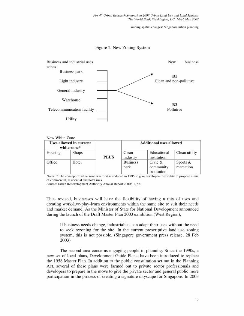
Stakeholding and collaboration with the public and private sectors are increasingly recognized as important to Singapore’s next phase of development. Reflecting the wider institutional mindset, the policy is for public-private partnership in plan implementation. This has brought changes to the top-down planning approach with growing action on facilitating and promoting growth in two major areas. The first is in terms of support for business, to make it easier, faster and cheaper for people to do business in Singapore. As an example, a new zoning system is introduced in the Master Plan 2003 to give businesses greater flexibility and choice of locations. The new zoning system as illustrated in Figure 2 moves away from the traditional prescriptive land use zoning system, which ascribes specific uses to designated zones towards an impact-based zoning scheme. The 2003 Master Plan Business 1 (B1) and Business 2 (B2) zones will replace the Warehouse, Light Industry and General Industry zones in the 1998 Master Plan while the Telecommunication and Utility zones henceforth is merged into a single Utility zone to cater to the convergence of these two services with technology advancement. Similarly, under the 2003 new Business-white zone a wider mix of uses will be permitted8.
8 The concept of white zone was first introduced in 1995 in the URA land sale program to provide greater flexibility in zoning. Under the URA sale of sites program land is sold to the private sector for development generally by public tender. Some small residential parcels and conservation shop houses are sold by public auction. The government land sale program has been used to promote the redevelopment of the city center, hotel development as well as conservation and other projects.
For 4th Urban Research Symposium 2007 Urban Land Use and Land Markets
The World Bank, Washington, DC, 14-16 May 2007
Guiding spatial changes: Singapore urban planning
12
Figure 2: New Zoning System Business and industrial uses New business zones
Business park
Light industry
General industry
B1
Clean and non-pollutive
Warehouse
Telecommunication facility
Utility
B2
Pollutive
New White Zone
Uses allowed in current
white zone* Additional uses allowed
Housing Shops Clean industry
Educational institution
Clean utility
Office Hotel
PLUS Business
park Civic & community institution
Sports & recreation
Notes: * The concept of white zone was first introduced in 1995 to give developers flexibility to propose a mix of commercial, residential and hotel uses. Source: Urban Redevelopment Authority Annual Report 2000/01, p21
Thus revised, businesses will have the flexibility of having a mix of uses and creating work-live-play-learn environments within the same site to suit their needs and market demand. As the Minister of State for National Development announced during the launch of the Draft Master Plan 2003 exhibition (West Region),
If business needs change, industrialists can adapt their uses without the need to seek rezoning for the site. In the current prescriptive land use zoning system, this is not possible. (Singapore government press release, 28 Feb 2003) The second area concerns engaging people in planning. Since the 1990s, a
new set of local plans, Development Guide Plans, have been introduced to replace the 1958 Master Plan. In addition to the public consultation set out in the Planning Act, several of these plans were farmed out to private sector professionals and developers to prepare in the move to give the private sector and general public more participation in the process of creating a signature cityscape for Singapore. In 2003
For 4th Urban Research Symposium 2007 Urban Land Use and Land Markets
The World Bank, Washington, DC, 14-16 May 2007
Guiding spatial changes: Singapore urban planning
13
the Urban Redevelopment Authority further launched an e-consultation portal to engage the population on specific draft guidelines and policies before they are finalized. In proclaiming the development plans are ‘your plans’ the planners have moved to more actively engage the community in the plan-making process. As ‘heartware’ issues of quality of life and place identity are being considered, the general tenor is towards a more collaborative approach in planning.
Taking off from the broad strategies of the Concept Plan, the Development Guide Plans gazette as the Master Plan in 1998 contain more detailed policies and control guidelines on land use zoning, building height, development intensity9, urban design, conservation and monuments, parks and waterbodies, and land use arrangement. The Development Guide Plans draw together all the land use, special and detailed controls within one plan to provide a transparent basis for the operation of development control10. There are 55 Development Guide Plans for the whole of Singapore. The preparation of each of these plans applies the principles of the Concept Plan within the more localized context of a specific planning area. With the development potential of a particular site set out in the Development Guide Plans, public and private sector developers can obtain a clear idea of what they can or cannot build on their land parcels. This helps to provide not only certainty but also transparency in the planning system. The Development Guide Plans are an important component in the Singapore planning system if development control is not to be arbitrary, unpredictable and unaccountable.
After more than four decades since its first introduction in 1959, comprehensive planning by means of the development plan and development control remains the cornerstone of Singapore’s planning system. Although the particular system of development plans in Singapore has had its origin in British practice, over the years it has sought to include a balance between flexibility and certainty in its development of a framework that facilitates the growth of Singapore as an international airport and seaport, a manufacturing and industrial base, and a regional and international centre of trade, commerce and finance. The central area is largely cleared of squatters and redeveloped with new infrastructure. Over the rest of the island, the development of public housing, industrial estates, transportation, parks and other public infrastructure has proceeded to take shape in an orderly pattern guided by the proposals of the Concept Plan (Motha and Yuen, 1999; Yuen, 1998; 2004). In many of these developments, the government has taken a proactive approach to realize the vision set out in the Concept Plan by investing in key infrastructure. Government commitment has remained a strong factor in Singapore’s plan implementation, and a key driver behind inter-agency collaboration.
Even though there are no rights to future development in the absence of valid planning permission, the Concept Plan serves as a common reference point on
9 Since 1989, density control in residential areas has been replaced by plot ratio, resulting in a single intensity control for all developments. See Motha and Yuen (1999), Chp 6. 10 Prior to the Development Guide Plans, several of these controls exist in written instructions or as separate plans outside the Master Plan documentation. The move to consolidate all controls in the Master Plan clarifies the planning parameters governing land in Singapore and is part of the ongoing effort to improve the planning system.
For 4th Urban Research Symposium 2007 Urban Land Use and Land Markets
The World Bank, Washington, DC, 14-16 May 2007
Guiding spatial changes: Singapore urban planning
14
appropriate development for the different agencies in their land management. As public investments have a long-term impact, these agencies are required to take a large vision, and have regard to the Concept Plan provisions when preparing their development proposals. In the area of public housing, for example, the government through the Housing and Development Board has built more than 900,000 dwelling units mainly in high-rise, high-density public housing estates and new towns with a large volume of related facilities (car parks, schools, markets, shops, parks, etc). Guided by the 1971 Concept Plan, many of the public new towns are located in high-density urban corridors adjacent to high capacity public transportation. This plan has facilitated the systematic and comprehensive planning of public housing estates and new towns to meet housing demands. Critical to the plan implementation is:
• the early designation of land in relevant locations for high-density public housing developments;
• better coordination between public housing developments and the provision of utilities; and
• the early planning of complementary uses to housing estates such as land for parks, educational and industrial uses.
Prior to the formulation of the Concept Plan, public housing estates and new towns were largely developed on a piecemeal basis with very little reference to the overall physical development strategy. With the Concept Plan setting out the likely directions for the future development of land, sectoral planning by the relevant public development agencies could be better coordinated. The impact of this could be seen in the planning and programming of large-scale public investment in infrastructure. The island-wide mass rapid transit and expressway networks, for example, could be planned on a comprehensive scale and in advance of implementation. As plan implementation is through the process of development control, the next section will examine that process of control more closely.
3. THE PROCESS OF CONTROL
The procedures for control (determination, approval, refusal, appeal) are set out in the Planning Act. Three main aspects are covered:
• the procedure to be followed in making an application for planning permission and in considering what decision to make;
• the limits within which planning controls operate so as to provide a mechanism against the making of an arbitrary decision and an abuse of power; and
• the machinery by which legal challenges can be made by an aggrieved person against the system.
For 4th Urban Research Symposium 2007 Urban Land Use and Land Markets
The World Bank, Washington, DC, 14-16 May 2007
Guiding spatial changes: Singapore urban planning
15
The powers of the Minister (for National Development) to decide planning applications and appeals, and to institute new rules are set out in the Planning Act. The Minister may by gazette appoint a person or persons to act as competent authority for the operation of the Planning Act. Currently, the Chief Planner of the Urban Redevelopment Authority is appointed as competent authority. All development applications must be made on prescribed forms, and submitted to the competent authority. A processing fee is charged for each application. The amount payable is set out in the subsidiary legislation (The Fee Schedule 2000), and is generally structured to correspond with the type, size and complexity of the application. Under its pro-business environment, the planners have produced development control handbooks and submission checklists to guide intending applicants through the different applications. Application forms for planning approval are available at the Urban Redevelopment Authority, Customer Service Counter, and over the Urban Redevelopment Authority webpage with increasing usage of information technology. The planners have also continually re-examined the procedures, and sought to reduce the red tape and processing time.
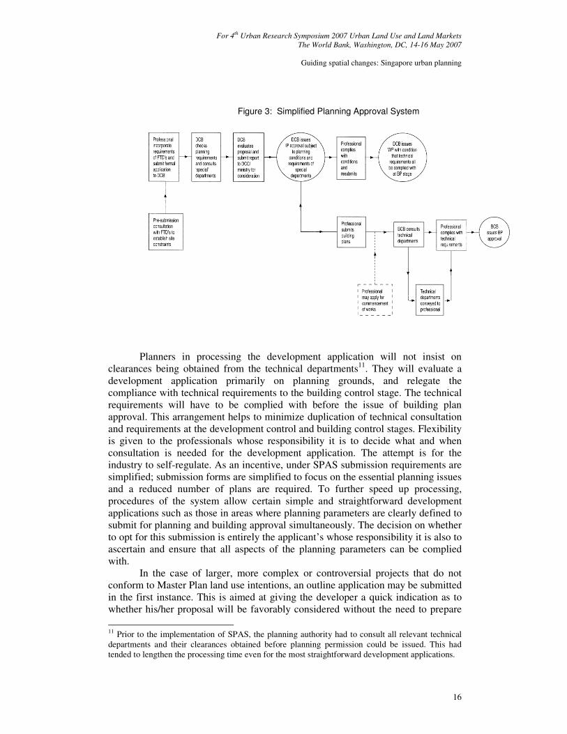
The competent authority has three months to determine the application. Where unavoidable circumstances so require the competent authority may defer the determination for such further period as he/she thinks fit. Most development applications are decided before the three months’ period; 95% of the 8800 applications received in 2000/01, for example, are reportedly cleared within eight weeks (Urban Redevelopment Authority Annual Report, 2000/01). Over the years, the planning authority has introduced various simplifying procedures to reduce the time taken to obtain planning permission. The Simplified Planning Approval System (SPAS) introduced since April 1987 is one such effort. SPAS seeks to separate development and building control procedures by calling for direct consultation between developers and the technical departments on their requirements before the submission of development plans (Figure 3).
For 4th Urban Research Symposium 2007 Urban Land Use and Land Markets
The World Bank, Washington, DC, 14-16 May 2007
Guiding spatial changes: Singapore urban planning
16
Planners in processing the development application will not insist on
clearances being obtained from the technical departments11. They will evaluate a development application primarily on planning grounds, and relegate the compliance with technical requirements to the building control stage. The technical requirements will have to be complied with before the issue of building plan approval. This arrangement helps to minimize duplication of technical consultation and requirements at the development control and building control stages. Flexibility is given to the professionals whose responsibility it is to decide what and when consultation is needed for the development application. The attempt is for the industry to self-regulate. As an incentive, under SPAS submission requirements are simplified; submission forms are simplified to focus on the essential planning issues and a reduced number of plans are required. To further speed up processing, procedures of the system allow certain simple and straightforward development applications such as those in areas where planning parameters are clearly defined to submit for planning and building approval simultaneously. The decision on whether to opt for this submission is entirely the applicant’s whose responsibility it is also to ascertain and ensure that all aspects of the planning parameters can be complied with.
In the case of larger, more complex or controversial projects that do not conform to Master Plan land use intentions, an outline application may be submitted in the first instance. This is aimed at giving the developer a quick indication as to whether his/her proposal will be favorably considered without the need to prepare
11 Prior to the implementation of SPAS, the planning authority had to consult all relevant technical departments and their clearances obtained before planning permission could be issued. This had tended to lengthen the processing time even for the most straightforward development applications.
Figure 3: Simplified Planning Approval System
For 4th Urban Research Symposium 2007 Urban Land Use and Land Markets
The World Bank, Washington, DC, 14-16 May 2007
Guiding spatial changes: Singapore urban planning
17
detailed plans. Put simply, an outline application is a broad proposal for testing the land use, plot ratio, building height and form on a development site, and finding out the planners’ planning intention for the site including if the site is affected by public schemes and its specific urban design or planning parameters. Outline permission could be issued within three to four weeks of an application. Outline permission does not therefore authorize the carrying out of that development or works or any other development or works. Outline permission is generally valid for a period of 6 months while the validity period for planning permission is two years12. The two-year time-span has been introduced by an amendment to the 1959 Planning Ordinance in 1964 to curb speculation and reduce the number of unused planning permissions. Since 2003, the applicant may also test out up to three different alternative development schemes in a single planning application under the multiple development options scheme. The process not only helps to reduce costs (the combined application fee is lower than that for separate applications) but also shorten processing time.
In response to increasing internet usage, the Urban Redevelopment Authority in 1997 has introduced a computerized planning application form for the construction of new buildings and amendments to approved plans. Since 1999, it has promoted the use of electronic submission over the internet under the Electronic Development Application (EDA) system. With EDA, applicants can submit text files and CAD drawings, and obtain on-line approval. Capitalizing on the Singapore ONE broadband network, EDA is part of the larger effort to reengineer the business process in the construction industry. It is the first step to the One-Stop Submission System developed under CORENET, the construction and real estate network that allows the construction and real estate industry to communicate and exchange information seamlessly. All types of development applications can be submitted using EDA. While 9% of all planning applications in 2000 were made over EDA, by 2004 the proportion has risen to 99% (Urban Redevelopment Authority Annual Report 2000/01; 2003/04). The majority, 95%, of e-applicants had received a decision within four weeks.
E-application offers several attractions. It improves on the timeliness of granting planning decisions and saves the applicant time, manpower and costs. On-line consultation and decision conveying process has been translated into faster consultation response and reply from the planner. Submission status check is also on-line. Compared to traditional paper submission, there is no coloring and printing of multiple copies of submission plans. The e-submission system supports a fast and hassle-free form-filling process that includes auto-computation of plot ratio, site coverage, communal open space and processing fees. E-submissions can be made at any time including after office hours and any place as long as there is internet connection. There are however certain minimum hardware (and software) requirements such as a minimum Pentium personal computer with 166 Mhz and
12 An application for extension of planning permission may be made no earlier than two months before the expiry date.
For 4th Urban Research Symposium 2007 Urban Land Use and Land Markets
The World Bank, Washington, DC, 14-16 May 2007
Guiding spatial changes: Singapore urban planning
18
32MB RAM, modem of minimum 56.6kbps, Netrust13 smartcard reader and Netrust smartcard certificate, and also, computing literacy.
Since 1995, Singapore has practiced an alternative process of plan lodgment that carries instant approval. Thus, upon acknowledgement of receipt of lodgement, applicant can proceed to apply for building control approval if required. Plan lodgment allows proposed additions and alterations, new constructions and material change of use development applications which comply with the planning and lodgment requirements to be lodged by qualified persons (QP). The QP is a registered architect or engineer. Deeming such works as authorized and thus not requiring planning approval, plan lodgment further reduces the time and cost for businesses, and promotes the QP to play a larger role in development control. It is part of the self-regulation process based on self-declaration of compliance where plans are approved immediately on the strength of QP endorsement that the plans have been checked and complied with all relevant guidelines and regulations. To enable businesses to respond quickly to market changes more building and use categories have been added over the years14. As of 2003, an estimated 40% (about 60 cases per month) of all change of use proposals qualifies for lodgment.
In the current climate of public participation, partnership with the community has also entered development control but at the policy level. The Urban Redevelopment Authority has actively engaged the businesses and community to review and reduce many of its rules and simplify development controls. Through the Public Officers Working to Eliminate Red Tape Scheme (POWER) initiated in 2002 it holds regular dialogue sessions with industry players with a view to review its development control guidelines and suggest business-responsive changes. For example, following one such session in Jan 2002, the Urban Redevelopment Authority has revised more than 12 industrial building guidelines (The Straits
Times, 9 April 2002). Extending what was originally a Ministry of Finance practice to review internal rules within government departments and statutory boards to cut red-tape, the Urban Redevelopment Authority has used this tool to engage businesses, professionals, residents and other end users to ‘dissect, question and redefine our development control guidelines and give their honest assessment and recommendations’ (Skyline, Nov/Dec 2000, p3).
Unlike the British system, the public is not consulted on planning applications. However, in recent years the public has been invited to comment on several major development projects, for example, the integrated resorts (a mixed-use development with a casino). In the present era of global city development the practice of development control has sought to become more market-responsive. The thrust of reforms has largely been in terms of streamlining the development control process to afford speed, flexibility and self-regulation to the private sector.
13 Netrust is a Certification Authority that provides online identification and security infrastructure to enable secure electronic transactions via the Internet and other wireless media. 14 The authorization of such works is defined in legislations: Planning (Development of Land – Lodgment Authorisation) Notification; Planning (Development of Land Authorisation for Housing and Development Board and Jurong Town Corporation) Notification; Planning (Changes in Use – Lodgment Authorisation) Notification.
For 4th Urban Research Symposium 2007 Urban Land Use and Land Markets
The World Bank, Washington, DC, 14-16 May 2007
Guiding spatial changes: Singapore urban planning
19
4. THE ASSESSMENT SYSTEM The decisions on planning applications are set forth in the planning legislation. Under the Planning Act, the competent authority may decide on an application for planning permission in one of three ways:
• grant planning permission unconditionally;
• grant the permission subject to certain conditions; or
• refuse planning permission. The decision must be given to the applicant by a notice in writing. On the basis of this notice, the applicant can lodge an appeal if he/she feels aggrieved. Since 1989, the competent authority is empowered to grant any planning permission as a provisional permission prior to the grant of planning permission. Provisional permission is generally valid for a period of 6 months unless a longer period is specified15. Where the competent authority is satisfied that all the conditions contained in a provisional permission has been complied with during the validity period of the provisional permission, the competent authority may grant planning permission subject to such further conditions as he thinks fit. In order not to delay development time, the competent authority may authorize either generally or specially the carrying out of specified preliminary works following the grant of provisional permission.
The crucial point about the decision in planning application is the criterion for its determination which is set out in the Planning Act: the competent authority ‘shall act in conformity with the provisions of the Master Plan and any Certified Interpretation Plan16 in so far as they may be relevant.’ This has had the effect of making the development plan, specifically the Master Plan, a strategic document in the development control process. An apparent purpose comes from the traditional role of development control, that development control is accepted as the means of implementing the land use plan. A second purpose is that the plan would give some degree of certainty to the applicant: the certainty of knowing in advance what is acceptable. Although largely plan-led, the competent authority under the Planning Act may determine when following circumstances arise, the application in the manner as the Minister may approve:
• where the land to which the application relates (i.e. the relevant land) is or will be required for any public purpose or for the provision of any utility services or infrastructural, social or transportation facility;
• where the relevant land or its locality is the subject of a planning, transportation, conservation or preservation study being carried out by the competent authority or any other public authority;
15 As with planning permission, an application for extension of provisional permission may be made no earlier than two months before the expiry date. 16 These are certified plans, prepared for the purpose of providing more detailed interpretation of the Master Plan. They are usually on a scale larger than the maps contained in the Master Plan.
For 4th Urban Research Symposium 2007 Urban Land Use and Land Markets
The World Bank, Washington, DC, 14-16 May 2007
Guiding spatial changes: Singapore urban planning
20
• where the provisions of the Master Plan in so far as it relates to the relevant land or its locality is being reviewed by the competent authority;
• where a proposal to amend the provisions of the Master Plan in so far as it relates to the relevant land or its locality has been submitted to the Minister for approval; or
• where the competent authority is of the view that the development proposed in the application is incongruent with the developments on land adjoining the relevant land or other land in the locality.
These circumstances offer the possibility of negotiating some discretion or what Jowell (1973, p178) terms as ‘room for decisional manoeuvre’ into the system of control to meet the dynamic nature of development in Singapore. In thirty years, the built-up area of Singapore has doubled, increasing from 26% in 1967 to 51% in 1997. With future changes, the built-up area is expected to expand to 70% to accommodate a larger population of 6.5 million in 40-50 years’ time. The desire for flexibility in strategic controls has seen the planning authority from time to time articulating planning policies and guidelines through circulars to professional bodies. In practice, those circulars often become policy directives, providing guidelines to developers as well as evaluation criteria in development control decisions. The purpose of those guidelines is, as the Minister for National Development explains, ‘to formulate flexible standards, encourage greater creativity and ensure that land is put to optimum use’ (The Straits Times, 19 April 1990). Together these offer the way where the element of certainty can be tampered with the desirability for flexibility and creativity in planning control. As the Chief Executive Officer, Urban Redevelopment Authority states,
Part of the URA’s job is to facilitate orderly development…But we must not over-control. The best way to do this is to listen to our customers, to trust them more and share responsibilities with them. (The Straits Times, 9 April 2002)
Discretion is not without limits. The Act in providing the circumstances for
discretion is also very clear on the limits of that discretion: the competent authority is to act under the watchful eye of the Minister for National Development. The Minister in turn is answerable to parliament for the activities of his ministry. In other words, such discretion is not absolute nor a matter of personal whim that leads to injustice, but operates within limits. It also reflects the way in which decision-makers account for their action. There is strong disincentive for corruption under the country’s intense anti-corruption policy. Under Singapore law, both the giver and the receiver of a bribe are guilty of corruption. They are liable on conviction to the same court punishment of a fine (up to S$100,000) or imprisonment (up to seven years) or to both; the penalties are more severe for members of parliament and public servants. What is more, the validity of the planning permission shall not be affected by such error or omission. In the event of an error or omission of any particulars relating to the description of any land or boundary, the competent
For 4th Urban Research Symposium 2007 Urban Land Use and Land Markets
The World Bank, Washington, DC, 14-16 May 2007
Guiding spatial changes: Singapore urban planning
21
authority may by gazette notification amends such error or omission and accordingly amends or adds to the planning permission.
A further way of ensuring accountability in the system is, as under the British system, enshrined in the right of applicant to appeal to the Minister. The applicant who is aggrieved by the decision may appeal to the Minister against that decision. Such appeals must be made within 60 days of the date of notification of the decision. The decision of the Minister shall be final; it shall not be challenged or questioned in any court. The Minister may also direct the competent authority to refer all or any applications to him for determination. The Minister’s decision on these applications shall be final. In addition, the Minister may make rules relating to the operational aspects of development control (such as the form and manner in which applications for planning permission to develop land, the manner in which the competent authority shall deal with applications for planning permission, the fees or charges to be paid, the manner in which appeals may be made and determined under the Act).
5. ENFORCEMENT OF PLANNING CONTROL
Any system of control must have some ultimate sanction to deal with contravention if it is to be effective as intended. It follows that enforcement of planning control is a very important element in the planning system. In Singapore, development control is enforced through criminal offence. Any person who develops land without planning permission commits an offence, and is liable on conviction to a fine or a term of imprisonment. An enforcement notice may be served on any person who is an owner or occupier of the land in question or has any other interest in the land or is carrying out operations on the land or is using the land for any purpose. The enforcement notice must be in writing, stating the breach of planning control, the measures and time to be taken to remedy the breach.
The penalties for non-compliance with an enforcement notice are severe. The offender shall on conviction be liable to a fine not exceeding S$200,000 or to imprisonment for a term not exceeding 12 months or to both. In the case of a continuing offence, to a further fine not exceeding S$10,000 for every day or part of it during which the offence continues after conviction. Over the years, with rising salaries and inflation, the amount of fine has been progressively increased. Notwithstanding the provisions of the Criminal Procedure Code, the Magistrate’s Court or a District Court is also empowered to impose the maximum penalties provided for an offence under the Planning Act. In addition, where the person fails to comply with the planning permission or its conditions, the competent authority may also cancel the permission. As with planning permission, the aggrieved person may appeal to the Minister against the enforcement notice.
The 1998 Planning Act also holds provision for the issue of an information notice. This notice may be served on any person who is an owner or occupier of the land, has any other interest in the land or is using the land in any way where it appears to the competent authority that there may have been a breach of planning control. The notice may ask for information on the usage and activities on the land.
For 4th Urban Research Symposium 2007 Urban Land Use and Land Markets
The World Bank, Washington, DC, 14-16 May 2007
Guiding spatial changes: Singapore urban planning
22
Failure to comply is an offence, and on conviction the offender is liable to a fine not exceeding S$5000 or to imprisonment for a term not exceeding 6 months or to both.
Notwithstanding differences in the way a breach of planning control is handled by different cities, the Singapore procedures for development control are in many ways largely influenced by the thinking behind the British 1947 Act. The whole concept of application, determination and appeal over planning applications, for example, exemplifies that influence as does the use of subsidiary legislation and the introduction of Use Classes Rules in 1960, and the fundamental aim of development control, which is still the implementation of the development plans in respect of land use and physical development. The simple premise of this is that development control in Singapore is the means by which public sector-derived land use policies are implemented, namely, by the grant (or withholding) of planning permission to applications to develop or change the use of land made by the government and private sector.
6. CONCLUSION Much of what we see in Singapore today has been constructed under the framework of the planning and development control system began in 1959. The system has raised certain contradictions and challenges. On the one hand, increases in population and traffic notwithstanding Singapore’s urban environment and quality of life over the years have visibly improved. The city as a whole is regenerated to become a modern, efficient city. Physical development appears to have taken place in an orderly, coordinated manner. On the other hand, as is perhaps typical of centralized planning, many of the developments, for example, public housing are criticized for their cookie-cutter standardization and monotony. Analysis and solutions are possible. In recent years, effort has been increasingly directed towards greater diversity and creativity in the city’s skyline and design. Many of the older public housing estates and towns are being renewed with focus on place identity. The 2001 Concept Plan has painted the vision of a vibrant, distinctive and sustainable city. Whatever the criticisms, the report card seems to indicate that the city has steadfastly held to the significance of development plans, instituting an enabling administrative, legislative and policy framework to realize their implementation. As Wehrfritz and Kolesnikov-Jessop (2007) state,
The unabashedly paternalistic model once earned Singapore the reputation as a “nanny state” in a region known for its all-night neon. Yet with many Asian cities now gridlocked and mired in pollution, the costs of laissez-faire development are more and more apparent—making Singapore’s centralized approach increasingly appealing.
The Singapore transformation over the past forty years demonstrates the strength and legitimacy of planning in guiding spatial changes. Plans are prepared, and importantly, they are implemented with relatively high levels of compliance with development control and planning regulations.
For 4th Urban Research Symposium 2007 Urban Land Use and Land Markets
The World Bank, Washington, DC, 14-16 May 2007
Guiding spatial changes: Singapore urban planning
23
Central to plan implementation is development control. Under present law and practice, no person in Singapore may develop any land without the planning permission of the competent authority. In its essentials, the Singapore system is firmly rooted in the ideology of British planning that brought under control the carrying out of any building, engineering, mining, or other operations in, on, over or under land or the making of any material change in the use of any buildings or land and limited severely what could be undertaken without planning permission. The term ‘develop’ is all-encompassing even though it goes on to make clear that some works and uses are not to constitute development. The procedure to be followed in making an application for planning permission, the limits within which planning controls operate, and the machinery by which legal challenges can be made by an aggrieved person against the system are all clearly set out in legislation. As Smith (2007) advocates from British planning,
We need to recognise however that effective planning cannot always be achieved through consensus. Where hard choices are required, clear and equitable decision-making frameworks are essential.
The objective of planning and development control in Singapore, as with
many other countries, is primarily to achieve the aims of town planning, more commonly, to provide orderly development in the interest of the community as a whole. The system has embodied processes that enable the implementation of planning policy objectives and plans in a changing environment. As argued above, planning and development control in Singapore is not static. It is by no means a mechanical, pre-ordained process. Dissatisfied with the rigidity of traditional master planning and development control measures and spurred by global trends, there has been a general move over the years to review the measures, reduce processing time, engage the stakeholders, and increasingly shift its control focus from being negative to becoming more facilitating in the promotion of development.
One such change is the introduction of new and more flexible business zones and white zones to facilitate business development as Singapore globalizes. Greater attention is focused on greenery, heritage conservation and place identity. Alternatives are being implemented to make the city more attractive and livable. Much more is being done to reach out and work in partnership with the community to create a distinctive, vibrant and sustainable city. This in turn has brought changes to the top-down planning approach. By acknowledging the need to work more closely with the public-private sectors in plan implementation, the planners are changing the power relations and the way development plans are being made. The global mantra of ‘act global and think local’ while presenting challenges has opened opportunities to reinvent public participation in planning.
Notwithstanding the various simplifications of procedures and controls, the desire to be pro-business is re-opening the debate on balance between the need for certainty and the scope for flexibility. Where does the balance lie especially in the light of the long-standing debate about flexibility and certainty in development control systems around the world? It is early days yet to know the full impact of the new zones and other pro-business development initiatives. While customer
For 4th Urban Research Symposium 2007 Urban Land Use and Land Markets
The World Bank, Washington, DC, 14-16 May 2007
Guiding spatial changes: Singapore urban planning
24
satisfaction with the planning authority’s facilitation service scores the high 90%, preliminary indication on industry response to ‘Government plans to give developers freer rein on white sites’ appears largely lukewarm, ‘don’t really add much’ (The Straits Times, 1 March 2003; Urban Redevelopment Authority Annual Report 2003/04). As Booth (2002) reminds from British experience, actors in land management favor flexibility in development control for different reasons. The emphasis on faster and easier development applications including instant approvals must not lose sight of the basic aims of development control. Too much flexibility can be a problem too.
There is another challenge to consider. Against the widening appeal of internet, plan submission appears likely to feature strongly in terms of electronic submission and plan lodgment. That implies that the private sector will, if it did not actually require them, to play an increasingly larger role in the self-regulation process. This development is not without problems. Key impediments include not just system constraint but also ‘liability’ problems highlighted by Low (2000) in a review of the scheme. Plan lodgment as now practiced only offers freedom from the normal process of development control by instantly permitting development provided it conforms to all the rules set out in the lodgment scheme. There is the question of the QP’s willingness to shoulder that entire responsibility in the face of what Low (2000) describes as ‘a punitive environment that leaves no room for mistakes to be made’. Related to this is a psychological barrier, the worry of QP, real or imagined that existing regulations may not be sufficiently flexible to take on board the special nature of some projects. That in consequence has led some to opt to continue with the normal process of development control rather than risk the liability. Unless these issues are resolved, streamlining the development control system could result in limited gain.
REFERENCES
Ashworth, W. (1954) The genesis of modern town planning, London: Routledge
and Kegan Paul Ltd. Booth, P. (2002) “A desperately slow system? The origins and nature of the current
discourse on development control” Planning Perspectives 17:309-323. Castells, M. (1981) “Towards a sociological theory of urban planning” in C. C.
Lemert (ed) French sociology: rupture and renewal since 1968, New York: Columbia University Press.
Chan, H. C. (1971) The politics of survival, Kuala Lumpur: Oxford University Press.
Denyer-Green, B. (1987) Development and planning law, London: The Estates Gazette.
Healey, P. (1988) “The British planning system and managing the urban environment” Town Planning Review 59(4):397-417.
Healey, P. (2005) Collaborative Planning: Shaping Places in Fragmented Societies, New York: Palgrave Macmillan.
For 4th Urban Research Symposium 2007 Urban Land Use and Land Markets
The World Bank, Washington, DC, 14-16 May 2007
Guiding spatial changes: Singapore urban planning
25
Healey, P., A. Doak, P. McNamara and M. Elson (1985) The implementation of planning practice and the role of development plans, Oxford: Department of Town Planning, Oxford Polytechnic.
Jowell, J. (1973) “The legal control of administrative discretion”, Public Law: 178-219.
Khublall, N. and B. Yuen (1991) Development control and planning law in Singapore, Singapore: Longman Singapore.
Koolhaas, R. and B. Mau (1995) SMLXL, Rotterdam: 010 Publishers. Lim, S. P. (2000) “Towards good governance: Promoting operational efficiency and
accountability” Proceedings of East Asia: Urban and city management core course, Singapore, World Bank Institute.
Low, C. H. E. (2000) The impact of self-regulation on the process of development control, unpublished MSc (Real Estate) thesis, National University of Singapore.
McGee, T. G. (1976) “Beach-heads and enclaves: the urban debate and the urbanisation process in South-east Asia” in Y. M. Yeung and P. Lo (ed) Changing South-east Asian cities: readings on urbanization, Singapore: Oxford University Press.
McLoughlin, J. B. (1973) Control and urban planning, London: Faber. Motha, P. and B. Yuen (1999) Singapore real property guide, Singapore: Singapore
University Press. Planning Act Cap 232 and subsidiary legislation, Singapore Statutes. Smith, R. (2007) The vision: Inclusive planning, The Royal Town Planning
Institute. Telling, A. E. (1986) Planning law and procedure, London: Butterworths. Urban Redevelopment Authority Annual Report, various years. Urban Redevelopment Authority (2001) Concept Plan 2001, Singapore: Urban
Redevelopment Authority. Wakeley, P. and N. You (2001) Implementing the Habitat Agenda: in search of
urban sustainability, London: University College London. Wehrfritz, G. and S. Kolesnikov-Jessop (2007) “Singapore leads way in green
architecture” Newsweek International, http://www.msnbc.msn.com/id/10756823/site/newsweek/ accessed on 12 March 2007 3:33pm.
Wong, A. and S. H. K. Yeh (ed) (1975) Housing a nation, Singapore: Maruzen Asia.
Yeung, Y. M. (1987) “Cities that work: Hong Kong and Singapore” in R. J. Fuchs, G. W. Jones and E. M. Pernia (ed) Urbanization and urban policies in Pacific Asia, London: Westview Press.
Yuen, B. (1998) (ed) Planning Singapore: from plan to implementation, Singapore: Singapore Institute of Planners.
Yuen, B. (2004) “Planning Singapore growth for better living” in M. Freire and B. Yuen (ed) Enhancing urban management in East Asia, Aldershot: Ashgate.
Yuen, B. (2005) Squatters no more: Singapore social housing, World Bank Third Urban Research Symposium: Land Development, Urban Policy and Poverty Reduction, April 4-6 2005, Brazilia, Brazil.

For 4th Urban Research Symposium 2007 Urban Land Use and Land Markets
The World Bank, Washington, DC, 14-16 May 2007
Guiding spatial changes: Singapore urban planning
26
Yuen, B. (2006) Reclaiming cultural heritage in Singapore, Urban Affairs Review 41(6): 830-854.