guidelines to general plan document - parks.ca.gov · the next three years. basing its efforts on...
TRANSCRIPT

CCaalliiffoorrnniiaa SSttaattee PPaarrkkss FFeebbrruuaarryy 22000022
PPLLAANNNNIINNGG HHAANNDDBBOOOOKKProvides guidance for the different levels of state park planning:
Systemwide / Regional PlanningUnit Classification and NamingGeneral PlanningManagement PlanningSpecific Project Planning
PLANNING HANDBOOK REVISIONSFebruary 2002
This document reflects text revisions that have been made to the Draft Planning Handbookdated March 27, 1998. These revisions were the result of a continuing effort by former membersof the General Plan Improvement Team (GPIT) and representatives from the various divisionsand service centers. This current effort is an on-going process that will improve information andguidance to planning teams and others preparing general plans, and provide a continuing focuson the need to clarify related processes.
This document will be maintained by the Northern Service Center and updated, as necessary,with input and participation by staff Department-wide and under the direction of the PlanningPolicy and Programming Committee. The Planning Handbook will also be posted on theDepartment’s Internet website, and updated periodically, as revisions become necessary oradditional guidelines are prepared.
If you wish to request copies or provide further input into this document, please direct yourrequest to:
Dave Keck, Supervisor, General Planning Northern Service CenterOne Capitol Mall, Suite 500Sacramento, CA 95814(916) 445-8903 or email [email protected]
Keith Demetrak, ChairPlanning Policy and Programming CommitteePlanning Division1416 9th StreetSacramento, CA 95814(916) 653-9377 or email [email protected]

California State Parks
Planning Handbook
February 2002
GRAY DAVISGovernor
RUSTY AREIASDirector
Department of Parks and RecreationP.O. Box 942896
Sacramento, CA 94296-0001
MARY D. NICHOLSSecretary for Resources

Revised – February 2002
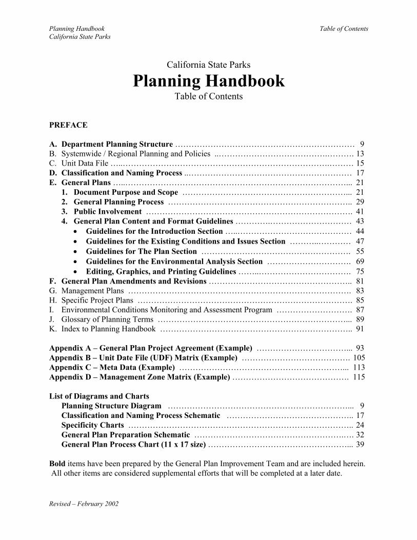
Planning Handbook Table of ContentsCalifornia State Parks
Revised – February 2002
California State Parks
Planning HandbookTable of Contents
PREFACE
A. Department Planning Structure ………………………………………………………… 9B. Systemwide / Regional Planning and Policies ..………………………………….………. 13C. Unit Data File …..………………………………………………………………….……… 15D. Classification and Naming Process ..…………………………………………………… 17E. General Plans …..………………………………………………………………………... 21
1. Document Purpose and Scope ……………………………………………………... 212. General Planning Process ………………………………………………………….. 293. Public Involvement …………………………………………………………………. 414. General Plan Content and Format Guidelines ………….………………………… 43
• Guidelines for the Introduction Section …..…………………………………… 44• Guidelines for the Existing Conditions and Issues Section ………..………… 47• Guidelines for The Plan Section ………………………………………………. 55• Guidelines for the Environmental Analysis Section …………………………. 69• Editing, Graphics, and Printing Guidelines ……..……………………………. 75
F. General Plan Amendments and Revisions …………………………………………….. 81G. Management Plans ………………………………………………………………………. 83H. Specific Project Plans ……………………………………………………………………. 85I. Environmental Conditions Monitoring and Assessment Program ………………………. 87J. Glossary of Planning Terms ……………………………………………………………... 89K. Index to Planning Handbook …………………………………………………………….. 91
Appendix A – General Plan Project Agreement (Example) ……………………………... 93Appendix B – Unit Date File (UDF) Matrix (Example) …………………………………. 105Appendix C – Meta Data (Example) ……………………………………………………... 113Appendix D – Management Zone Matrix (Example) ……………………………………. 115
List of Diagrams and ChartsPlanning Structure Diagram …………………………………………………………... 9Classification and Naming Process Schematic ……………………………………….. 17Specificity Charts ……………………………………………………………………….. 24General Plan Preparation Schematic ……………………………………………….…. 32General Plan Process Chart (11 x 17 size) ……………………………………………... 39
Bold items have been prepared by the General Plan Improvement Team and are included herein. All other items are considered supplemental efforts that will be completed at a later date.

Planning Handbook Table of ContentsCalifornia State Parks
Revised – February 2002
Planning Handbook PrefaceCalifornia State Parks
Revised – February 2002
PREFACE
In the summer of 1994, the Department’s Planning Policy and Programming Committee (PPPC)(formerly the General Plan Policy Committee – GPPC) appointed a 9-person group to examinethe manner in which the Department prepared unit-level general plans, and to makerecommendations for changes in the planning process and the resultant general plan documents. The desired changes were to respond to the then-current perceptions that the then-standardgeneral plans took too much time to prepare, and were too long, too detailed and too constrainingin their content. The group’s goal was to create a new process and new standards for generalplan preparation.
The appointed study group, the General Plan Improvement Team (GPIT), met periodically overthe next three years. Basing its efforts on the Total Quality Management approach, the GPITsystematically examined the current approach to general plan preparation in order to determinehow to achieve the goals of their assignment. The GPIT’s draft materials were reviewedthroughout the Department and were consolidated as a two-part document, which contained aTeam Report and a draft Planning Handbook, issued on March 27, 1998. The Department onApril 27, 1999 accepted this joint document, and its approach to general planning, asDepartmental Notice #99-07.
Following summary inventory and analysis of the unit’s natural, cultural and recreationalresources, the general plan document would provide a guiding vision for the unit. It wouldindicate broad guidance as to the sort of management that would best protect its resources andmake them available for appropriate public enjoyment and use. The general plan would providea vision and focus on the unit’s current critical issues rather than attempt a comprehensiveoverview of all likely issues. More detailed planning for the unit, for the management of certainresources or the development of specific facilities or programs, would be the subject of separate,subsequent, more specific studies and plans.
The recommendations of the GPIT Team Report were not confined just to alterations in thegeneral plan and its preparation. It did do this, but in doing so it went on to recommendnecessarily related major adjustments in other aspects of Department’s entire existing planningsystem (see figure entitled Park Planning Structure). Three major adjustments are perhaps mostnoteworthy:
• Due to the simplification, brevity and vision-orientation of the new type of general plan,subsequent and more specific unit-level management plans took on greater importance;
• As broad guidance to general planning, the study and development of a guidingframework of Systemwide Planning and Policies took on great importance; and
• It was emphasized that the initiation, development, and upkeep of Unit Data Files wasnecessary to serve both the on-going management of park units and to be a major factorin reducing the amount of resource inventory work that precedes the preparation of ageneral plan.

Planning Handbook PrefaceCalifornia State Parks
Revised – February 2002
The draft Team Report had identified seven high priority supplemental efforts that would beneeded in order to bring the recommended new Departmental planning system into being. In thethree years since the Report was issued, little or no work has been done on any of thesesupplemental efforts. This is why the corresponding gaps (their “placeholders”) which appearedin the draft Planning Handbook still remain in this revised version.
The general plan for Chino Hills SP, approved in February of 1999, was the first general planprepared using the GPIT approach. The general plans for Pfeiffer Big Sur SP (October 1999)and Castle Rock SP (March 2000) also used this approach, and a number of other general planscurrently in process will be using the GPIT model. With three years of experience using thisnew Departmental planning system and its new approach to general planning, the GPPCappointed a short-term study group to determine two things:
• What was going well with the new GPIT approach to general plan preparation and whatsort of changes or corrections might be needed to permit desired improvements; and
• What additional work was needed and feasible in the effort to continue to create thebroad new Departmental planning system recommended by the GPIT?
Meeting on March 13, 2001, the consensus of the study group was that:
• A number of relatively modest changes should be made in the current process ofpreparing unit-level general plans;
• The draft Planning Handbook should be revised to reflect these changes, and a new,updated edition should be issued for the benefit of staff and other concerned parties; and
• At this time, there were insufficient resources to allow work on the previously identifiedimportant supplemental efforts, which the original Team Report had maderecommendations for and established placeholders in the draft Planning Handbook.
Based on the efforts of this study group, the Planning Handbook was revised and issued in thispresent form in February of 2002. It is believed that this revised handbook will provide betterguidance to those who will be preparing unit-level general plans. It will also serve as a reminderof the type and amount of additional work that is needed to transform the Department’s totalplanning system into the new, integrated framework envisioned by the GPIT.
Reflecting this last point, this revised handbook must be taken not as a final product, but only asa point-in-time indication of how general plans are prepared by the Department. Realization ofthe Department’s new planning system, in total, will take a great deal of additional work over thecoming years and is critical to good comprehensive planning.
OTHER GUIDING DOCUMENTSThis Planning Handbook replaces all guidelines prior to 1997 that refer to the specifics ofgeneral plan preparation and content, including portions of “Guidelines for ResourceDocuments” (September 1987), and “Guidelines for Preparing Interpretive Elements” (May1992).

Planning Handbook Department Planning StructureCalifornia State Parks
Revised – February 2002 9
DEPARTMENT PLANNING STRUCTURE
PLANNING STRUCTURE OVERVIEW
The following schematic portrays six broad planning components, which encompass the fullrange of planning needs in the Department. The schematic portrays the relationships amongcomponents. It should be noted that the components do not necessarily relate in a linear process.For instance, some unit planning efforts can be, and are, accomplished without the benefit of ageneral plan.
Planning Handbook Department Planning StructureCalifornia State Parks
Revised – February 2002 10
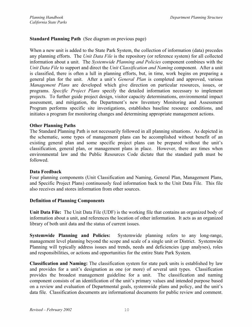
Standard Planning Path (See diagram on previous page)
When a new unit is added to the State Park System, the collection of information (data) precedesany planning efforts. The Unit Data File is the repository (or reference system) for all collectedinformation about a unit. The Systemwide Planning and Policies component combines with theUnit Data File to support and direct the Unit Classification and Naming component. After a unitis classified, there is often a lull in planning efforts, but, in time, work begins on preparing ageneral plan for the unit. After a unit’s General Plan is completed and approved, variousManagement Plans are developed which give direction on particular resources, issues, orprograms. Specific Project Plans specify the detailed information necessary to implementprojects. To further guide project design, visitor capacity determinations, environmental impactassessment, and mitigation, the Department’s new Inventory Monitoring and AssessmentProgram performs specific site investigations, establishes baseline resource conditions, andinitiates a program for monitoring changes and determining appropriate management actions.
Other Planning PathsThe Standard Planning Path is not necessarily followed in all planning situations. As depicted inthe schematic, some types of management plans can be accomplished without benefit of anexisting general plan and some specific project plans can be prepared without the unit’sclassification, general plan, or management plans in place. However, there are times whenenvironmental law and the Public Resources Code dictate that the standard path must befollowed.
Data FeedbackFour planning components (Unit Classification and Naming, General Plan, Management Plans,and Specific Project Plans) continuously feed information back to the Unit Data File. This filealso receives and stores information from other sources.
Definition of Planning Components
Unit Data File: The Unit Data File (UDF) is the working file that contains an organized body ofinformation about a unit, and references the location of other information. It acts as an organizedlibrary of both unit data and the status of current issues.
Systemwide Planning and Policies: Systemwide planning refers to any long-range,management level planning beyond the scope and scale of a single unit or District. SystemwidePlanning will typically address issues and trends, needs and deficiencies (gap analyses), rolesand responsibilities, or actions and opportunities for the entire State Park System.
Classification and Naming: The classification system for state park units is established by lawand provides for a unit’s designation as one (or more) of several unit types. Classificationprovides the broadest management guideline for a unit. The classification and namingcomponent consists of an identification of the unit’s primary values and intended purpose basedon a review and evaluation of Departmental goals, systemwide plans and policy, and the unit’sdata file. Classification documents are informational documents for public review and comment.
Planning Handbook Department Planning StructureCalifornia State Parks
Revised – February 2002 11
They are accompanied by a classification and naming recommendation to be considered forapproval by the State Park and Recreation Commission.
General Plan: The general plan is the primary management guideline for a unit defining aframework for resource stewardship, interpretation, facilities, visitor use and services. Generalplans define an ultimate purpose, vision, and intent for unit management through goalstatements, guidelines, and broad objectives, but stop short of defining specific objectives,methodologies and designs on how to accomplish these goals.
Management Plans: Management plans define the specific objectives, methodologies and/ordesigns on how management goals will be accomplished. Occurring on an as-needed basis, theyare typically focused on specific management topics, goals or issues.
Specific Project Plans: Specific project plans are the detailed implementation plans needed toaccomplish specific project(s) or management plan(s).
Environmental Conditions Monitoring and Assessment Program: Unit-specific monitoringplans are developed to assess the status and condition of a park’s vital resources and theeffectiveness of management actions. They describe the important components of a specificpark unit that need to be monitored with respect to stated management goals, priorities, andissues. They also specify what, how, and when to inventory, monitor, and assess eachcomponent.

Planning Handbook Department Planning StructureCalifornia State Parks
Revised – February 2002 12

Planning Handbook Systemwide / Regional Planning and PoliciesCalifornia State Parks
Revised – February 2002 13
SYSTEMWIDE / REGIONAL PLANNING AND POLICIES
DEFINITION / SCOPE
Systemwide planning refers to any long-range, management level planning beyond the scope andscale of a single unit or District. Systemwide Planning will typically address issues and trends,needs and deficiencies (gap analyses), roles and responsibilities, or actions and opportunities forthe entire State Park System (or the Department of Parks and Recreation beyond the State ParkSystem). Systemwide planning may also focus on one or more of the core elements of theSystem; i.e., Natural Resources, Cultural Resources, Recreation, Interpretation/Education,Facilities, Public Safety and Visitor Services. Typically, systemwide planning will have a 20-year horizon. Examples of systemwide planning include:
State Park System PlanCalifornia Outdoor Recreation PlanPublic Opinions and Attitudes on Outdoor Recreation in CaliforniaCalifornia History PlanStatewide Trails PlanBioregional studiesEconomic Impact Studies
Regional planning may encompass several units, an entire District or parts of two or moreDistricts. By focusing on the relationship among units, regional plans facilitate coordination,provide for greater consistency, create economic efficiencies, and/or allow for greatereffectiveness in management of the State Park System. Through regional planning, theallocation of staffing and funding is addressed in multi-unit coordination. Regional planningcreates greater effectiveness in general planning by considering priorities between and amongunits, such as the coordination of interpretive media for several units that are linked thematicallyor geographically. Examples of regional plans may include:
Central California Coast Mountain Bike Recreation PlanNative Grasslands Restoration PlanPrescribed Fire Management PlanNatural Communities Conservation Plans
Guidelines/Level of DetailThe level of detail is determined by the complexity of the issues and/or policies addressed.
Timing and CircumstancesSystemwide Planning should be done on an on-going basis and actively pursued by theDepartment, however, it may be issue driven and pursued as needed. Agency regulations aremade available and are updated as soon as approved texts are available.
Approvals

Planning Handbook Systemwide / Regional Planning and PoliciesCalifornia State Parks
Revised – February 2002 14
Dependent upon subject matter, the Director or appropriate Division Chief will approveSystemwide Plans and Policies.
SUPPLEMENTAL EFFORTS – Systemwide / Regional Planning and Policies /
This section is one of the important supplemental efforts previously identified in thePlanning Handbook. The Department will provide additional information and guidance,as necessary, when sufficient resources become available.

Planning Handbook Unit Data FileCalifornia State Parks
Revised – February 2002 15
UNIT DATA FILEDEFINITION / SCOPE
The Unit Data File (UDF) is the working file that contains an organized body of informationabout a unit, and references the location of other information. It acts as an organized library ofboth unit data and the status of current issues. This file contains information (including maps)about a unit’s acquisition and history, natural and cultural resources, demographics, populationdiversity, visitor use patterns, recreation experiences, land use, facilities, and key issue papers. The UDF encompasses much of what was traditionally referred to as the unit’s ResourceInventory. As proposed, the UDF does not necessarily contain a summary of the information ordocumentation of any evaluation or analysis of the data, but may reference the complete files inother locations. In addition to its value to the general plan process, this comprehensivecollection of information will be a valuable asset to other planning and management efforts. Asfile information is digitized, the UDF will be accessed as an electronic data base and map file.
Guidelines/Level of DetailDepartment standards, district priorities, and the availability of information and staff shape thelevel of detail. Focused efforts will be directed to meet the information requirements necessaryto proceed with a general plan; as well as to fill critical information gaps identified by theResource Inventory and Monitoring Program. More discussion regarding the application of theUDF is provided in the section titled General Plan Process (Preplanning Phase). An exampleUDF Matrix (Inventory checklist) is provide in Appendix B, which can be used, or adapted, fordetermining the inventory work needed prior to proceeding with a general plan.
Timing and CircumstancesThe data in this file is continuously updated with additional information by staff from throughoutthe Department. Data collection efforts, plans, projects, reports and scientific investigations,visitor use surveys, resource monitoring programs, resource management projects, CEQAreview, consultant contracts and the focused efforts of technical teams will all contributeinformation to the Unit Data File. Gathering future data and converting existing data in digitalform will be necessary in order to easily update and share this information.
ApprovalsSince this is a dynamic collection of information, no formal approval is needed for individualunit data files. However, additions, deletions, and corrections will be made only by authorizedstaff.
SUPPLEMENTAL EFFORTS – Unit Data File
This section is one of the important supplemental efforts previously identified in thePlanning Handbook. The Department will provide additional information and guidance,as necessary, when sufficient resources become available.

Planning Handbook Systemwide / Regional Planning and PoliciesCalifornia State Parks
Revised – February 2002 16

Planning Handbook Classification and Naming ProcessCalifornia State Parks
Revised – February 2002 17
CLASSIFICATION AND NAMING PROCESS
The following schematic describes the key process actions in naming and classifying a unit ofthe State Park System, followed by a brief description on what action is intended.
Following the acquisition or transfer of property to the Department of Parks and Recreation forinclusion into the State Park System, the Department will provide the commission with arecommendation containing the unit’s permanent name and classification.1 Once acquired, theproperty becomes the responsibility of the Department to manage for its protection of resourcevalues, and in some cases, provide access for interim public use. The need for resourceinventories and unit classification is necessary to properly identify and guide management ofappropriate visitor activities within the Department’s guidelines for management of natural andcultural resources. Before classification, the Department refers to the property as a “project” andnot a unit.
1.0 Identify Significant Natural and Cultural Resources
Once the land is in State ownership, the Department’s staff has access to the land to begin siteinvestigations and resource studies. Generally, this is the first opportunity to identify anddetermine the significant natural and cultural sites and features that exist in the unit. Knowingthe significant values and sensitivities of these resources, as well as the historical uses of theland, will guide the Department staff in determining the appropriate unit classification. This level
1 See California State Park and Recreation Commission Statements of Policy and Rules ofOrder: Policy Number 3 – CLASSIFICATION AND NAMING UNITS OF THE STATE PARK SYSTEM
Recommendappropriate unit
classification3.0
Identify significantnatural and cultural
resources1.0
Prepare unitinventory of features(Resource Summary)
2.0
Recommend unitname & alternatives
3.1
Submit proposedname & classificationto the SP&R Comm.
4.1
Select preferredname and unitclassification
4.0
Naming andclassification hearing
5.0
Notice to DPRDivisions of
Commission action6.0
Collect and publishmaterials
6.1
Planning Handbook Classification and Naming ProcessCalifornia State Parks
Revised – February 2002 18
of resource inventory is intended to provide a broad understanding of the significant resourcevalues and not a detailed accounting of all sites and features.
2.0 Prepare Inventory of Features
The Inventory of Features (Resource Summary) document is the culmination of the initialresearch and site investigations, which should summarize the significant resource values of thispark property. This inventory will be included in the document package submitted to the StatePark and Recreation Commission for its consideration when classifying or reclassifying a unit. Division 5, Chapter 1 – Article 1.7. Section 5019.50 – 5019.74 of the Public Resources Codeshould be consulted in making a determination of the appropriate unit classification.
3.0 Recommend appropriate unit classification
Following the initial investigations and preparation of the unit Inventory of Features, theDepartment’s staff (usually at the District or in the Resource Divisions) will evaluate theinformation and alternatives and make a recommendation for unit classification. This staffrecommendation is submitted to the Planning Policy and Programming Committee (PPPC),along with the Inventory of features, for review and comment. It should also be noted thatclassification of sub-units, such as natural or cultural preserves, may be proposed at any timefollowing the unit classification through a similar process. Generally, subclassifications areidentified and proposed during the preparation of a general plan and require a more detailedresource inventory, in order to determine resource significance and appropriate boundaries.
3.1 Recommend Unit name
Frequently units are given a name to which they have been accustomed due to location,association, history, and general usage. Occasionally, land will be acquired into the State ParkSystem having dead restrictions or naming requirements, which should be researched first. Typically, staff will recommend three alternatives for consideration, indicating the preferredalternative with justification.2 Refer to the California State Park and Recreation CommissionStatements of Policy and Rules of Order: Policy Number 3 and Chapter 18, Unit Classificationsof the Departmental Directives on Resource Management for guidance.
4.0 Select preferred name and unit classification
The Director is responsible for selecting and recommending the preferred name and unitclassification based on the PPPC review and executive staff recommendations. The Inventory ofFeatures (Resource Summary) and the Department’s recommendation for naming andclassification are forwarded to the State Park and Recreation for their consideration andapproval. This classification proposal shall include a map and legal description depicting the unitboundary.
2 See California State Park and Recreation Commission Statements of Policy and Rules ofOrder: Policy Number 3 – CLASSIFICATION AND NAMING UNITS OF THE STATE PARK SYSTEM. Also refer to Chapter 18, Unit Classifications 1810 of the Departmental Directives onResource Management for the California State Park System.

Planning Handbook Classification and Naming ProcessCalifornia State Parks
Revised – February 2002 19
4.1 Submit proposed classification to the SP&R Commission
The State Park and Recreation Commission is charged with the responsibility for naming andclassifying units in the State Park System.
The classification report will be submitted, with a letter of transmittal, to the Commission forindividual member review prior to the scheduled hearing date. The report will include theInventory of Features (Resource Summary) along with the recommended unit name andjustification for classification and designation.
5.0 Naming and classification hearing
The Department will provide proper public notice and make a presentation on the resourcevalues and classification proposal at a scheduled hearing of the SP&R Commission, whichallows the public an opportunity to provide testimony on the unit classification and name.
Per Public Resources Code 5002.3. A public hearing shall be scheduled and noticed bythe State Park and Recreation Commission to consider each matter of classification orreclassification of a unit.
Notice of the hearing shall be posted per the requirements of Public Resources Code5002.3. The content of such a notice shall substantially comply with the requirements ofSection 11346.5 of the Government Code.
Copies of the Department's inventory of features (Resource Summary) with therecommendation and justification for name and classification shall be made available tothe public at the Department's appropriate district offices on the last date of publication ofthe notice.
6.0 Notice to DPR Divisions of Commission action
Following Commission approval, the Department shall submit proper notice to all DPRDivisions and other appropriate agencies regarding this action, with the approved name and unitclassification. This important step will place the new name and classification into theDepartment records for accounting and management programs.
6.1 Collect and Publish Materials
The Planning Division will publish and make the standard limited distribution of theclassification document, which includes the following items: explanatory cover sheet(standardized format), DPR letter to the Commission, Commission resolution, and ResourceSummary.

Planning Handbook Classification and Naming ProcessCalifornia State Parks
Revised – February 2002 20
Planning Handbook General PlansCalifornia State Parks Document Purpose and Scope
Revised – February 2002 21
GENERAL PLANSDOCUMENT PURPOSE AND SCOPE
PURPOSE
The general plan is the primary management document for a unit of the State Park System,establishing its purpose and a management direction for the future. By providing a definedpurpose and vision, long-term goals, and guidelines, the general plan defines the broadestmanagement framework for a unit’s development, ongoing management, and public use. Thereafter, this framework will guide day-to-day decision-making and serve as the basis fordeveloping focused management plans, specific project plans, and other management actionsnecessary to implement the goals of the general plan.
General plans are required by law prior to the development of a unit and serve as a ProgrammaticEnvironmental Impact Report (E.I.R.). The general plan is based on an analysis of informationcontained in the Unit Data File and additional information gathered during the planning effort. Itis also based on systemwide planning and policies, and input received from both the public andother agencies through a planned public involvement process.
The Public Resources Code: Division 5, Chapter 1, Article 1, Section 5002.2 requires that ageneral plan be prepared prior to the development of permanent facilities, and specifically statesthat “so long as such construction does not result in the permanent commitment of a resource ofthe unit”.
In the past, the Department considered general plans to have a 15 to 20-year planning horizon orlife span. Under this planning structure of broad, goal-oriented general plans and subordinate,more specific management plans, general plans are no longer thought of as having endpoints or afinite life span. Instead, general plans will have no specified timeframes. They will only bereconsidered for amendments or revisions when circumstances and needs dictate. Because oftheir broader scope and the focus on purpose and direction, they will likely be more enduring. General plans will be more adaptable to changing circumstances and customer needs. The goalswill be constant while the specific approach(es) for implementing those goals may change withnew technology or customer needs.
SCOPE
Content of General PlanningGeneral planning is holistic in approach, considering both internal and external influences, themultiple strategies of the Department’s mission, and the inherent resource values and facilities ofthe unit. Overlapping or conflicting purposes or goals are integrated into a consistent whole. This is the only place in the planning for a unit where this occurs.
General planning also considers the unit within the larger context of the State Park System,utilizing systemwide plans already in place. It considers the unit’s context within surrounding

Planning Handbook General PlansCalifornia State Parks Document Purpose and Scope
Revised – February 2002 22
state park units, regional planning, land uses, and other influences, and it considers local andregional recreational opportunities and services.
General planning includes a public involvement process.
Level of Specificity
The level of detail in general plans is shaped by the Public Resources Code (PRC), CEQArequirements, Planning Handbook, and Project Agreement. The Project Agreement represents ajoint strategy between the general planning team and Policy Planning and ProgrammingCommittee for each general plan, which spells out staffing, funding, schedule, and productexpectations. It also highlights the major issues that Department management wants addressedin the general plan. The most significant change in the general plan from previous Departmentpractices is the limiting of its level of specificity. Previous general plans contained not onlybroad strategies and goals but also specific objectives, methodologies and designs on how to goabout accomplishing the stated goals. The scope of the general plan in the new park planningstructure does not include specific objectives and the details of how strategies and goals are to beaccomplished. Instead, specific objectives and strategies will be developed when needed insubsequent planning components (management plans or project plans).
General Plan strategies and goals define an ultimate purpose and aim of management, but stopshort of defining a specific accomplishment and/or timeframe for fulfilling those goals.
Essentially, the general plan is a “goal-based”, as opposed to an “objective-based”, document. The following two charts are provided to clarify the scope of the general plan.
Goal as used in this report means a general, overall, and ultimate purpose, aim or intenttoward which management will direct effort. Goals are not necessarily measurableexcept in terms of the achievement of component objectives which attainment of the goalinvolves.
Guidelines as used in this report are a general set of parameters that provide directionstowards accomplishing goals.
Objective as used in this report is a specific statement of expected accomplishment ordesired future condition toward which management will direct effort in the context ofstriving to achieve a broader goal. Objectives are achievable, and where possible,measurable and time specific.

Planning Handbook General PlansCalifornia State Parks Document Purpose and Scope
Revised – February 2002 23
The chart below demonstrates the differences between general plans and management plans. The“Content” column highlights those questions that almost certainly will need to be addressed ineach type of document.
PLANNING DOCUMENT CONTENTGeneral Plan What (type only)
Why (purpose) Where (general zones, areas, clarification of overlapping goals)
Management Plan / Specific Project Plan How (methods, design) When (time, schedule) Where (site specific) What (specific type, size, shape)
The level of specificity should be the same in most unit general plans, answering what, why, andwhere type questions. However, more specific planning questions on “how” or “when”proposals will be implemented may need to be included to further clarify the intent, or to resolvewhat appears to be overlapping or conflicting planning goals.
At times the integration of planning activities at more than one level (e.g. general planning andmanagement planning) may be necessary to meet management’s needs. However, the level ofdetailed planning or design accomplished for the sake of the management plan should not bespecifically included as part of the general plan document.
The charts on the following pages are included to show examples of the level of detail orspecificity appropriate for each of the various components of the Department’s planningstructure, including general planning, management planning, and specific project planning. From top to bottom, each hypothetical statement leads to a proposal of greater detail. The mostdetailed planning is done at the Management Plans and Specific Project Plans levels.
Revised – February 2002 24
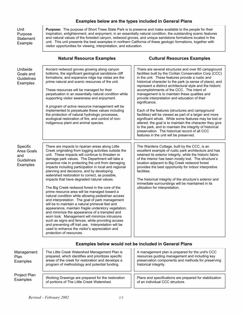
Purpose: The purpose of Short Trees State Park is to preserve and make available to the people for theirinspiration, enlightenment, and enjoyment, in an essentially natural condition, the outstanding scenic featuresand natural values of the forested canyon, redwood groves, and unique sandstone formations located in theunit. This unit presents the best examples in northern California of these geologic formations, together withvisitor opportunities for viewing, interpretation, and education.
Natural Resource Examples Cultural Resources Examples
UnitPurposeStatementExample
UnitwideGoals andGuidelinesExamples
Ancient redwood groves growing along canyonbottoms, the significant geological sandstone cliffformations, and expansive ridge top vistas are theprime natural and scenic resources of the unit.
These resources will be managed for theirperpetuation in an essentially natural condition whilesupporting visitor awareness and enjoyment.
A program of active resource management will beimplemented to perpetuate these values includingthe protection of natural hydrologic processes,ecological restoration of fire, and control of non-indigenous plant and animal species.
Project PlanExamples
ManagementPlanExamples
SpecificArea GoalsandGuidelinesExamples
Working Drawings are prepared for the restorationof portions of The Little Creek Watershed.
The Little Creek Watershed Management Plan isprepared, which identifies and prioritizes specificareas of the creek for restoration and develops aprogram of methodology and potential funding.
There are several structures and over 60 campgroundfacilities built by the Civilian Conservation Corp (CCC)in the unit. These features provide a rustic andhistorical character to the park (a sense of place), andrepresent a distinct architectural style and the historicaccomplishments of the CCC. The intent ofmanagement is to maintain these qualities andprovide interpretation and education of theirsignificance.
Each of the features (structures and campgroundfacilities) will be viewed as part of a larger and moresignificant whole. While some features may be lost oraltered, the goal is to maintain the character they giveto the park, and to maintain the integrity of historicalpreservation. The historical record of all CCCfeatures in the unit will be preserved.
The Wardens Cottage, built by the CCC, is anexcellent example of rustic park architecture and hasretained its exterior integrity, while the historic fabricof the interior has been mostly lost. The structure’slocation adjacent to Big Creek redwood forestprovides the best opportunity for indoor interpretivefacilities.
The historical integrity of the structure’s exterior andimmediate surroundings will be maintained in itsutilization for interpretation.
A management plan is prepared for the unit's CCCresources guiding management and including keypreservation components and methods for preservinghistorical integrity.
Plans and specifications are prepared for stabilizationof an individual CCC structure.
There are impacts to riparian areas along LittleCreek originating from logging activities outside theunit. These impacts will continue to threaten ordamage park values. The Department will take aproactive role in protecting the unit from damagingimpacts including participation in local and regionalplanning and decisions, and by developingwatershed restoration to correct, as possible,impacts that have degraded natural values.
The Big Creek redwood forest in the core of theprime resource area will be managed toward anatural condition while allowing pedestrian accessand interpretation. The goal of park managementwill be to maintain a natural primeval feel andappearance, maintain fragile understory vegetation,and minimize the appearance of a trampled andworn look. Management will minimize intrusionssuch as signs and fences, while providing accessand preventing off trail use. Interpretation will beused to enhance the visitor’s appreciation andprotection of resources.
Examples below would not be included in General Plans
Examples below are the types included in General Plans

Revised – February 2002 25
Vision: Short Trees State Park is a place of spectacular scenic beauty--a natural area unencumbered byhuman habitation or visual intrusions. It offers to visitors of all ages and abilities access to the heart of thepark where they can walk among unique geological formations, experience the magnificent presence ofancient redwoods, and hear the thunderous sound of water falling over steep canyon walls. It is a place forvisitors to seek personal renewal and gain inspiration from nature's power and beauty.
Interpretive Examples Recreation Examples
Unit VisionStatementExample
UnitwideGoals andGuidelinesExamples
Project PlanExamples
ManagementPlanExamples
The primary interpretive theme at this unit is:Humans and natural forces have interacted hereover time, continuously using, changing, andredefining the landscape's inherent values.
Interpretation will emphasize the values of the oldgrowth redwoods and the important park-makingrole of the CCCs.
The interpretive period for the unit covers the flow ofhistory extending from the earliest known humanoccupation to the present.
In support of the primary theme, interpretation at theLittle Creek Area will show how people have used,influenced change in, and eventually restored thisfragile area.
The primary theme is: Timber cutting broughtsettlement to the area and changes to the land thateventually spurred park creation and restoration.
In the Little Creek Area management will integratethe goals of interpretation and resourcemanagement by providing first-hand opportunitiesfor visitors to experience past and on-goingecological restoration.
A primary goal is to provide park visitors with highquality outdoor recreational opportunities, day useand overnight, that are directly related to the unit'sinherent natural values.
The unit’s diverse scenery from heavily shadedforest understory, to open canyon vistas, to ridgetoppanoramas provides outstanding opportunities fortrail-type recreation. Multi-use trails will allow visitoraccess to the four prime resource areas of the unit--Big Creek, Lover's Ridge, Little Creek, and MuleFlat.
To provide for visitors of various abilities anddesires, a system of trails will consist of increasinglylarge loops away from core public use areas.
A ridge-top trail and overlook will be sited in theLovers' Ridge Area.
Trails in the Lovers' Ridge Area will be laid out anddesigned to enhance the visitor's experience of thenatural environment. The intent is to give trail usersthe feeling that they are immersed in wilderness. Visual impacts from other trail use and artificialfacilities will be minimized.
The goal of park management will be to providerecreational access and opportunities in the BigCreek redwood forest that supports its naturalnessand primeval qualities.
A Trail Management Plan is prepared. The planidentifies trail corridors to and around the Lovers'Ridge Area. It also identifies appropriate types andlevels of trail use. In addition, it coordinates with theInterpretive Plan goals for this area, as well as forthe entire unit.
An interpretive plan is prepared, which defines aninterpretive program for the Two Forks portion of theLittle Creek Area. The program's primary focus ison the rich legacy of CCC features. Plan proposalsinclude exhibit panels identifying and interpretingthe areas CCC structures and the development ofan interpretive walking trail.
Construction drawings and specifications areprepared for the development and installation ofinterpretive panels and trail in the Two Forks area.
Plans and specifications for the Lovers' Ridge Trailand Overlook are prepared to guide construction bya volunteer trail crew.
Examples below are the types included in General Plans
Examples below would not be included in General Plans
Specific AreaGoals andGuidelinesExamples

Revised – February 2002 26
UnitwideGoals andGuidelinesExamples
UnitPurposeand VisionStatementExamplefor StateHistoricPark
The purpose for interpretation atBrock Mansion SHP will be toexpand visitor awareness,understanding, and appreciation ofthe mansion and significance ofMarshall Brock in California andU.S. history. Interpretation isconsidered to be essential inproviding the quality parkexperience.
The primary interpretive period isthe period of Marshall Brock’sgovernorship, 1868-1876. Thesecondary interpretive period is thelife of Marshall Brock dating frombirth through education, personaldevelopment, and business andcivic activities after political office.
Purpose: The purpose of Brock Mansion SHP is to provide for the people an opportunity to view the mansion andgrounds as they appeared during the Brock period of ownership, 1868 to 1882, and to tell the story of this extraordinaryCalifornian. The mansion and grounds represent how Governor Marshall Brock and his family developed and lived inthis historic property and how his governorship and business played a significant role in California’s history. Thearchitectural type, style, and age of the mansion have no comparison in California with a remarkable integrity of historicfabric for the period.
Vision: The Brock Mansion is an historic place in California providing an opportunity for visitors to submergethemselves in a distinctive period in California history surrounded by authentic furnishings and artifacts that give asense of place and history. Many Californians and foreign visitors of all ages and background visit the mansion topartake of the interpretive exhibits and tours and or participate in special events or living history programs.
Cultural Resources Examples Interpretive Examples Recreation Examples
A principle guiding theunit’s development andprovision for publicuse is that visitorenjoyment andappreciation is enhancedby their participation inhealthful recreationactivities associated withthe Unit’s primaryresources and facilities. Also guiding thedevelopment is the beliefthat visitors will expect tobe able to do more thansimply to look at the Unit’scultural features.
The Brock Mansion retains a very highdegree of historic fabric. The architecturaland structural qualities will be taken intoaccount during development andmaintenance of the building to achieve thedesired uses while causing minimumdisturbance to historic fabric.
The primary management goal is to preserveand restore the Brock Mansion and toprovide special events, interpretation, sales,and public use facilities within the mansionproper. Restoration and use will be guidedby historical significance. For example,highest quality restoration and public accesscontrol will be in areas of greater historicalsignificance.
Conversely, adaptive changes to allow forpublic use and interpretation will be in areasof lesser historical significance. The exteriorof the main structure will be restored asclosely as possible to the building’sappearance around 1876. The interior willbe restored to the Brock period, 1868 to1882. Historic fabric from that period will notbe significantly altered or removed toaccommodate uses.
A large number of original furnishings of theBrock Mansion have been obtained andpreserved by the Department. Theseartifacts will be crucial to the process ofaccurately restoring house museum roomsand creating interpretive exhibits. The unit’spurpose, vision, and primary interpretivethemes and the Scope of CollectionsStatement guide artifacts, appropriate foracquisitions at Brock Mansion SHP. Thosematerials not appropriate for interpretation atthe unit, or of minimum public benefit will notbe acquired, but referred to more appropriatelocations.
[MAP] - A map is presented of the floor planof the historic structure dividing the areawithin into several major managementcategories for levels of historic preservationand use from museum-quality restoration toadaptive use.
A primary theme is: The Brock Mansion is a symbol of politicalauthority, wealth, and power in 19th-Century California.
Purchasing a publication or a replica artifact can be an importantaspect of reinforcing a visitor’s experience to the mansion orpursuing a deeper knowledge of the unit’s themes. It is the intent inthe unit’s development to provide a sales room or area within themansion. Sales items should have a direct relationship to themansion and its history.
Public access will be provided to all major areas and floors of themansion and to the grounds. Public access will be controlledrelative to the need to insure the protection of resources. Forexample: only small well-controlled tour groups would access roomswith mostly original family furnishings. In contrast, rooms such asthe ballroom with little or no furniture or artifacts will accommodatelarger and less-controlled groups.
Integration of disabled and other special needs visitors is to besought in the development of public access, and provision forenjoyment of the mansion.
It is expected that the Brock Mansion will be especially popular withschool groups. The development of facilities and programs will beprovided for young students and other types of visitors with varyingdegrees of interest and knowledge. During the Brock period of themansion, many varied activities took place such as formal balls,dinners, and important meetings in relationship to government andpolitics. Operation of the mansion will provide for continuation ofthis historical use of the mansion with special events of the day, andliving history programs
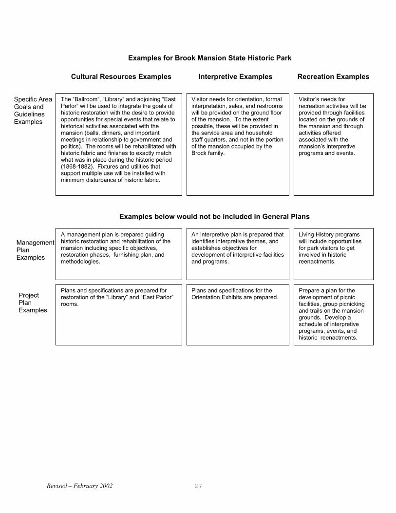
Revised – February 2002 27
ProjectPlanExamples
Plans and specifications are prepared forrestoration of the “Library” and “East Parlor”rooms.
An interpretive plan is prepared thatidentifies interpretive themes, andestablishes objectives fordevelopment of interpretive facilitiesand programs.
Plans and specifications for theOrientation Exhibits are prepared.
Living History programswill include opportunitiesfor park visitors to getinvolved in historic reenactments.
ManagementPlanExamples
A management plan is prepared guidinghistoric restoration and rehabilitation of themansion including specific objectives,restoration phases, furnishing plan, andmethodologies.
Prepare a plan for thedevelopment of picnicfacilities, group picnickingand trails on the mansiongrounds. Develop aschedule of interpretiveprograms, events, andhistoric reenactments.
Specific AreaGoals andGuidelinesExamples
The “Ballroom”, “Library” and adjoining “EastParlor” will be used to integrate the goals ofhistoric restoration with the desire to provideopportunities for special events that relate tohistorical activities associated with themansion (balls, dinners, and importantmeetings in relationship to government andpolitics). The rooms will be rehabilitated withhistoric fabric and finishes to exactly matchwhat was in place during the historic period(1868-1882). Fixtures and utilities thatsupport multiple use will be installed withminimum disturbance of historic fabric.
Visitor needs for orientation, formalinterpretation, sales, and restroomswill be provided on the ground floorof the mansion. To the extentpossible, these will be provided inthe service area and householdstaff quarters, and not in the portionof the mansion occupied by theBrock family.
Visitor’s needs forrecreation activities will beprovided through facilitieslocated on the grounds ofthe mansion and throughactivities offeredassociated with themansion’s interpretiveprograms and events.
Cultural Resources Examples Interpretive Examples Recreation Examples
Examples below would not be included in General Plans
Examples for Brook Mansion State Historic Park

Planning Handbook General Planning ProcessCalifornia State Parks
Revised – February 2002 28
Planning Handbook General Planning ProcessCalifornia State Parks
Revised – February 2002 29
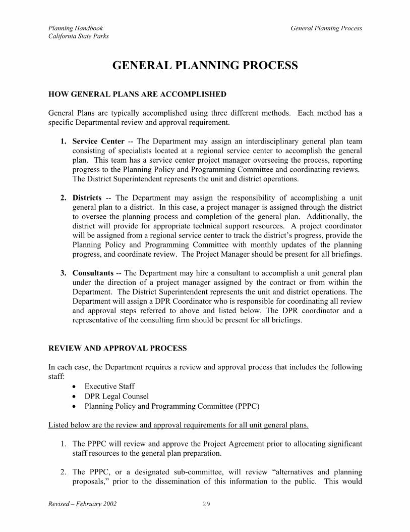
GENERAL PLANNING PROCESS
HOW GENERAL PLANS ARE ACCOMPLISHED
General Plans are typically accomplished using three different methods. Each method has aspecific Departmental review and approval requirement.
1. Service Center -- The Department may assign an interdisciplinary general plan teamconsisting of specialists located at a regional service center to accomplish the generalplan. This team has a service center project manager overseeing the process, reportingprogress to the Planning Policy and Programming Committee and coordinating reviews. The District Superintendent represents the unit and district operations.
2. Districts -- The Department may assign the responsibility of accomplishing a unit
general plan to a district. In this case, a project manager is assigned through the districtto oversee the planning process and completion of the general plan. Additionally, thedistrict will provide for appropriate technical support resources. A project coordinatorwill be assigned from a regional service center to track the district’s progress, provide thePlanning Policy and Programming Committee with monthly updates of the planningprogress, and coordinate review. The Project Manager should be present for all briefings.
3. Consultants -- The Department may hire a consultant to accomplish a unit general planunder the direction of a project manager assigned by the contract or from within theDepartment. The District Superintendent represents the unit and district operations. TheDepartment will assign a DPR Coordinator who is responsible for coordinating all reviewand approval steps referred to above and listed below. The DPR coordinator and arepresentative of the consulting firm should be present for all briefings.
REVIEW AND APPROVAL PROCESS In each case, the Department requires a review and approval process that includes the followingstaff:
• Executive Staff • DPR Legal Counsel• Planning Policy and Programming Committee (PPPC)
Listed below are the review and approval requirements for all unit general plans.
1. The PPPC will review and approve the Project Agreement prior to allocating significantstaff resources to the general plan preparation.
2. The PPPC, or a designated sub-committee, will review “alternatives and planningproposals,” prior to the dissemination of this information to the public. This would

Planning Handbook General Planning ProcessCalifornia State Parks
Revised – February 2002 30
typically occur prior to the second and/or third public meetings, or posting on the Internetwebsite.
3. The PPPC (Executive Staff, optional) will be briefed on the Preliminary General Plan,following Departmental review and prior to release of the Preliminary General Plan &Draft EIR for public CEQA review.
4. The Executive Staff and appropriate Field Division Chief will be briefed prior to thescheduled Park & Recreation Commission hearing on the General Plan.
General plan briefings will include staff necessary to provide answers to questions brought up bythe PPPC or Executive Staff. By direction of the PPPC or Executive Staff, a briefing or issuepaper may be requested of the general plan project manager, and could eliminate the need for ascheduled briefing. Department reviews should include ample time (two weeks) and sufficientplan copies (approximately 12) for distribution to various divisions and coordinated response tothe planning team. Electronic versions of the documents being reviewed are also preferred.
PROCESS CHART
The General Planning Process chart (at the end of this section) provides an overview of thetypical planning steps, tasks, responsibilities, time frames, and the sequence of planning eventsor milestones in the planning process. The actual planning tasks and their completion times willbe determined by the Project Teams and may vary greatly between general plans. This variationis expected due to the differences in unit classification, number and type of planning issuesinvolved, size of the park and the extent of public participation in the planning process. TheProject Teams will determine the required tasks and their estimated completion times for eachgeneral plan.
PREPLANNING PHASE
Prior to the preparation of a general plan, an adequate amount of unit information must begathered and resource inventory work completed. This collection of unit data forms the basis foranalysis of issues in determining the need for a general plan and its priority with other units.During this phase, three primary actions occur: (1) An evaluation for completeness of the UnitData File (UDF) and identification of major planning issues, (2) Recommendation by the DistrictSuperintendent, Service Center Manager, or the assessment team to prepare a general plan, and(3) PPPC authorization to form the project team and proceed with a general plan.
Prerequisites for General Plan Request
When anticipating a request to prepare a general plan, a level of preplanning work is required bythe requesting office (generally the District), to review the Unit Data File and clarify unit issuesand what is expected by such a plan. An assessment team made up of multidiscipline planningservices from a Service Center and/or the district’s planning staff may be needed to fulfill this

Planning Handbook General Planning ProcessCalifornia State Parks
Revised – February 2002 31
step. This team shall consist of appropriate staff that can make judgments on the adequacy of thefile. A typical team may include the District or Park Superintendent, Resource Ecologist,Cultural Resource Specialist(s), Landscape Architect, Park and Recreation Specialist, Architect,Engineer, etc.
Before making this request, the District or assessment team must review the Unit Data File, aworking file containing or referencing to an organized body of information about the unit, todetermine the completeness of resource inventories. This review shall also include an evaluationof existing conditions, issues and possible options, political climate (locals and governments),etc. This review and evaluation will help determine if a general plan is the appropriate vehicle(or proper time) to address and resolve the identified issues or unit problems.
This preplanning work should:
• Define clearly the major problem(s) or issue(s) that provides the basis for requesting ageneral plan. Definition of the major problems and issues will set the stage fordetermining the scope of work and the benchmark for where to start evaluations in thegeneral plan process.
• Evaluate the completeness of the Unit Data Files. Prior to the preparation of the generalplan, an adequate amount of unit information must be gathered and resource inventorywork completed. This collection of unit data forms the basis for analysis of issues indetermining the need for a general plan and its priority with other units. TheSuperintendent may at any time convene an interdisciplinary evaluation team (assessmentteam) to look at the information contained in the UDF. The evaluation team is chargedwith the task of determining if adequate data is available to proceed with the generalplan. The assessment team also determines if available information has been summarizedsuch that a future planning team would be able to determine what is “significant” and caneasily comprehend the resource information. The evaluation portion of the UDF Matrixform (see Appendix B) is used to determine if sufficient information is available or as atool to identify if gaps exist prior to scheduling a general plan. These information gapsmay be filled in by assignment to District staff, requesting staff from the Service Center,contracting, or by other appropriate means.
• Explore planning issues and options for the best planning approach. Discuss the
feasibility and likeliness that a general planning effort would result in a plan that resolvesthe major problems or produces the intended outcomes, such as benefits of a publicplanning process, political or funding support, or provision of services and facilities.Developing a brief understanding of this feasibility will help determine the desired scopeof the general plan, whether it’s a focused plan, an amendment, a full general plan, ormanagement plan that’s needed. If it is anticipated to be more of a “focused” generalplan, then a more site-specific evaluation and cost analysis may be required. Forexample, a desire to develop a specific facility may require additional studies or analysisto satisfy the need of a more detailed environmental impact report for the general plan.

Planning Handbook General Planning ProcessCalifornia State Parks
Revised – February 2002 32
Once a determination has been made by the District Superintendent, Service Center Manager, orthe assessment team to request a general plan, the unit is prioritized by the Planning Policy andProgramming Committee (PPPC) with others in the State Park System. Upon assignment to theproject team, work begins on the resource summary, planning issues are clarified, and a workplan is developed. This work plan is prepared in the form of a Project Agreement and submittedfor approval by the PPPC. General planning officially begins upon the completion of this phaseand the authorization by the PPPC.
GENERAL PLAN PREPARATION
The following schematic describes the key process actions in the preparation of a general plan,followed by a brief description on what action is intended and what value it has in the process.
Research &Describe Exist.
Conditions4.0
CompleteProject
Agreement3.0
Define Issues &Options2.0
Form ProjectTeam
1.0
Prepare PlanAlternatives
6.0
Analyze the Causes &Opportunities
5.0
Finalize theGeneral Plan
9.0
Review and ApproveGeneral Plan
8.0
Produce GP & EIRDocument
7.0
1.0 Form Project (Planning) TeamThe first step in the process is the formation of the Project (planning) Team. The planning anddecision-making process should be performed by an interdisciplinary planning team and involvepublic participation and coordination with other state and local agencies. The Project Teamshould include a district representative and persons experienced and knowledgeable in themanagement and interpretation of both natural and cultural resources, state park operations, andland use planning for recreation opportunities and public use. The Project Team can be formedin either the Service Centers, Districts, or Headquarters offices, and will work closely with theDistrict Superintendent for the purpose of preparing a general plan for a unit in his or her district.
2.0 Define Issues and Options

Planning Handbook General Planning ProcessCalifornia State Parks
Revised – February 2002 33
The Project Team must first understand and define the planning issues they expect to address inthe general plan. They must also review the UDF to identify “gaps” in the resource inventoryand determine how much additional information is needed to adequately address known planningand management issues.
3.0 Complete Project AgreementThe Project Agreement provides a framework in which the Department can make advanceddecisions about the scope and schedule of a planning effort. It is a contract between the ProjectTeam and the PPPC for preparation of the general plan. The agreement establishes the scope ofwork and level of issue resolution that the team expects to address in the general plan and servesas a benchmark for the team to start the planning process.
Upon the assignment of a general planning project, the PPPC outlines their expectations for thedesired scope and time frame for project completion. The project team prepares a ResourceSummary (if one is not currently available). The team then prepares a concise workplan thatdetails the scheduling milestones, staffing needs and funding requirements. The workplanidentifies inventory information gaps that the team will need to fill prior to completing thegeneral plan. It also summarizes, point by point, the issues expected to be addressed andresolved by the Final General Plan. Finally, the workplan notes the need for any focusedplanning that should be addressed by the Project Team, distinct from the general plan but a partof the planning team’s work (for example, management plans). This Draft Project Agreement isthen forwarded to Legal Counsel and the PPPC for review and approval, followed by revisionsas needed. A presentation to the PPPC is scheduled at this point.
During the course of a planning process, unexpected issues can arise, important information canbe discovered, staff is sometimes redirected and statewide planning priorities change. As soon asthese changes occur, the Project Agreement will be amended by agreement between PPPC andthe Project Team. Amendments will be made through a memo from the Service Center Manager(or District Superintendent), with justification and an approval block for the PPPC chairperson. A Project Agreement should be used for all large planning assignments, not merely generalplans. Appendix A includes the Big Basin Redwoods SP General Plan Project Agreement as anexample.
4.0 Research & Describe Existing ConditionsDuring this phase, the planning team becomes intimately familiar with what is known about theunit as it relates to their scope of work. The project team works to gain a common understandingabout existing conditions. Some research may be needed to clarify knowledge of conditions, andhow they have changed over time. It may be necessary to amend the Project Agreement if theamount of research needed exceeds what was originally anticipated. It may be necessary toamend the Project Agreement to meet newly identified project needs and planning issues. Project teams will employ numerous methods to gain this understanding about the physical andsocial conditions of the unit. This process would also include contacts with other agencies, usersurveys, public meetings, interviews, etc. in order to identify stakeholders of the general plan andunderstand their needs and concerns about the future of the unit.

Planning Handbook General Planning ProcessCalifornia State Parks
Revised – February 2002 34
Recognizing that the general plan is considered a “project” for the purposes of CEQA,consideration must be given as early in the process, as is appropriate, for describing the existingor baseline conditions for the assessment of the potential environmental impacts of alternativeproposals.
5.0 Analyze Causes and OpportunitiesPlanning teams will analyze known problems, and identify or suggest causes that might explainthe issues being considered. In addition to known issues, there may be local and regional trendsthat have (or will have) a major influence on the park environment. This is the time to recognizeand understand demographic trends, existing or proposed land uses that may create controversy,neighboring land use changes, and local governing rules that will affect the park. Resourcesensitivities and constraints are identified through the analysis of existing natural and culturalconditions.
At this point in the process, when the planning team has completed its data gathering andresource inventories, an environmental checklist should be prepared that identifies the subjectareas and issues to be addressed in the environmental analysis. The project team shall alsoprepare the Notice of Preparation, in coordination with the Legal Office, and submit thisdocument to the required agencies and interested organizations, as required by the CaliforniaEnvironmental Quality Act.
6.0 Prepare Plan AlternativesThis is the time when agreement is reached on the unit vision and purpose, and a preferred planalternative is developed. In the decision-making process towards a preferred plan, a range ofalternative goals and objectives should be created. The analysis of issues, problems, andopportunities (5.0) is used to develop alternatives and goals to be achieved, expressed in terms ofdesired resource conditions and visitor experiences. Broad categories of land use may bedefined, and potential recreation opportunities are identified. The set of recommended goals anddesired outcomes is analyzed for environmental and public concerns. Planning alternatives areevaluated for their potential effect on the environment, and possible mitigation measures areidentified.
The planning team presents draft planning alternatives for consideration by park staff, otheragencies, and the general public. To reach consensus on a preferred plan or desired outcomes,this phase of the process will likely include several team workshops and meetings involvingother participants with park planning and land management responsibilities. Some alternativesmay also require additional field investigation and study to verify the feasibility of the team’sproposal. Planning materials developed during this step typically include such things asnewsletters, correspondence, workshop maps and summaries of public and agency(s) response. Also included are descriptions of how various alternatives were evaluated, selected and justified. This information becomes part of the UDF for future reference.
More detailed planning scenarios may be prepared in order to determine a goal’s feasibility andto communicate the possible implications of the goals, but these scenarios are not a part of thegeneral plan document. This information will be placed in the UDF, and used in thedevelopment of future management plans and specific project plans. It may be desirable to

Planning Handbook General Planning ProcessCalifornia State Parks
Revised – February 2002 35
immediately follow-up a general plan with a management or project plan, as determined in theProject Agreement. If so, alternative goals could be fully developed and considered for eachplanning level, but each type of plan remains a separate document.
Public evaluation of the appropriate alternatives is part of this phase. A planning workshop orpublic meeting is scheduled for public review and discussion of alternative plan proposals. Controversial issues and solutions may require review and direction by the PPPC prior topresentation of these ideas to the public.
Developing a preferred plan requires a creative synthesis of alternatives. The varied alternativesare analyze to determine which combination of options best serves the park purpose and vision,DPR goals, and the public’s interest in the park’s future. Several steps outlined in the followingpages are involved in the development of a preferred or single plan for the park. This processmay vary from one general plan to another, and resulting maps, text, and illustrations may lookdifferent from one park to the next.
The preferred plan proposals are reviewed by the PPPC prior to public review, to facilitate high-level feedback, support, guidance and general concurrence. Substantial changes in the plan orpolicy decisions made by the PPPC may require revisions by the project team and resubmissionof the plan to the PPPC before proceeding into full document production. 7.0 Produce General Plan / EIR DocumentThe general plan is the primary management document for a park, establishing its purpose and amanagement direction for the future. This document also constitutes the Environmental ImpactReport, as required by the Public Resources Code Sections 5002.2 and 21000 et seq. Preparationof this document shall follow the General Plan Guidelines described in this Planning Handbookfor general content, level of specificity and layout. Through this planning process, the documentis presented in four drafts, as determined by the level of review and decision-making authorityand sequential order of planning steps.
• Preliminary Draft - Team Review• Draft General Plan - Department Review (PPPC & Legal) • Preliminary General Plan/ Draft EIR - CEQA Document - Public Review• Preliminary General Plan/ Final EIR - Incorporates Public Comments & DPR Responses• Final General Plan - SP&R Commission Approved
Elsewhere, this Planning Handbook provides general guidelines and standards for graphicpresentation and document layout. Project Teams, however, may use different staffing, mediaand processes in preparing the general plan documents. The reason for this is due to the differentcustomer needs and availability of equipment and staff. Therefore, Project Teams, with PPPCapproval, will determine the best production methods to ensure customer satisfaction andcontinuous improvement of general plan documents.
8.0 Review and Approve General PlanThe Department’s review and approval process is described here in the identification of theproduct, or outcome of the process and evolution of the planning document.
Planning Handbook General Planning ProcessCalifornia State Parks
Revised – February 2002 36
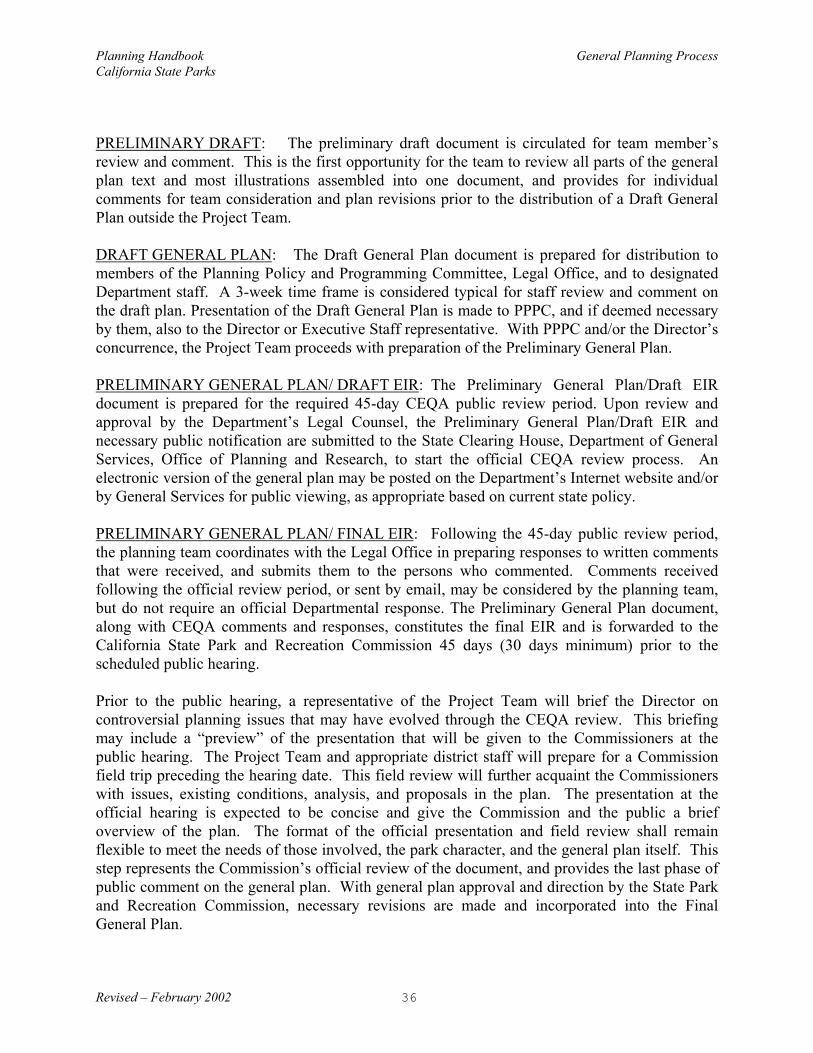
PRELIMINARY DRAFT: The preliminary draft document is circulated for team member’sreview and comment. This is the first opportunity for the team to review all parts of the generalplan text and most illustrations assembled into one document, and provides for individualcomments for team consideration and plan revisions prior to the distribution of a Draft GeneralPlan outside the Project Team.
DRAFT GENERAL PLAN: The Draft General Plan document is prepared for distribution tomembers of the Planning Policy and Programming Committee, Legal Office, and to designatedDepartment staff. A 3-week time frame is considered typical for staff review and comment onthe draft plan. Presentation of the Draft General Plan is made to PPPC, and if deemed necessaryby them, also to the Director or Executive Staff representative. With PPPC and/or the Director’sconcurrence, the Project Team proceeds with preparation of the Preliminary General Plan.
PRELIMINARY GENERAL PLAN/ DRAFT EIR: The Preliminary General Plan/Draft EIRdocument is prepared for the required 45-day CEQA public review period. Upon review andapproval by the Department’s Legal Counsel, the Preliminary General Plan/Draft EIR andnecessary public notification are submitted to the State Clearing House, Department of GeneralServices, Office of Planning and Research, to start the official CEQA review process. Anelectronic version of the general plan may be posted on the Department’s Internet website and/orby General Services for public viewing, as appropriate based on current state policy.
PRELIMINARY GENERAL PLAN/ FINAL EIR: Following the 45-day public review period,the planning team coordinates with the Legal Office in preparing responses to written commentsthat were received, and submits them to the persons who commented. Comments receivedfollowing the official review period, or sent by email, may be considered by the planning team,but do not require an official Departmental response. The Preliminary General Plan document,along with CEQA comments and responses, constitutes the final EIR and is forwarded to theCalifornia State Park and Recreation Commission 45 days (30 days minimum) prior to thescheduled public hearing.
Prior to the public hearing, a representative of the Project Team will brief the Director oncontroversial planning issues that may have evolved through the CEQA review. This briefingmay include a “preview” of the presentation that will be given to the Commissioners at thepublic hearing. The Project Team and appropriate district staff will prepare for a Commissionfield trip preceding the hearing date. This field review will further acquaint the Commissionerswith issues, existing conditions, analysis, and proposals in the plan. The presentation at theofficial hearing is expected to be concise and give the Commission and the public a briefoverview of the plan. The format of the official presentation and field review shall remainflexible to meet the needs of those involved, the park character, and the general plan itself. Thisstep represents the Commission’s official review of the document, and provides the last phase ofpublic comment on the general plan. With general plan approval and direction by the State Parkand Recreation Commission, necessary revisions are made and incorporated into the FinalGeneral Plan.

Planning Handbook General Planning ProcessCalifornia State Parks
Revised – February 2002 37
9.0 Finalize General PlanThe Final General Plan is the Preliminary General Plan as amended and approved plan by thePark and Recreation Commission at its public hearing. Following the hearing, a Notice ofDetermination (includes findings by the Commission regarding environmental impacts) isprepared by the Project Team and Legal Office for the Director’s signature and filed with theOffice of Planning and Research.
Also following the hearing, the planning team will editorially transform the Preliminary GeneralPlan into the Final General Plan by making necessary corrections and changes in both contentand format. This would also include the public comments and Department responses (final EIR),most often published in a separate CEQA document. A photo-ready copy of these finaldocuments will be prepared, including its text, the Commission resolution(s), illustrations, maps,the credits page and a cover. These materials will conform to Departmental standards for thesedocuments, including format, needed text, use of color, etc., and reference to supplementaldocuments.
The Department will arrange for the publication and the appropriate distribution of both the finalplan document and the supplemental CEQA document (includes public comments and staffresponses) and provide for the appropriate filing of such materials for future reproduction. ThePlanning Division will add the plan’s new purpose statements to the Department’s AccessDatabase and insure that appropriate Divisions are notified of name or classification changes thatwill affect unit programs.
The Project Team Manager will make available to the Department’s Intranet manager anelectronic version of the Final General Plan as well as a MetaData summary of the document(see Appendix C for example). Both items will conform to the Department’s current standardsand specifications.
After completing the final plan preparation, the planning team will place into the subject unit’sUnit Data File the formal and informal materials generated in the course of the planning process.These materials would include general background information, details on the plan alternativesconsidered, any special studies, and all newly gained resource information, as well as relevantcorrespondence and notes from meetings held during the planning process. These materialswould include both hard copy and electronic items.

Planning Handbook General Planning ProcessCalifornia State Parks
Revised – February 2002 38

Planning HandbookCalifornia State Parks
Revised – February 2002
39
REMOVE THIS PAGE
INSERT 11 X 17 TIP-OUTGENERAL PLAN PROCESS CHART
Page 39
REMOVE THIS PAGE

Planning Handbook General Planning ProcessCalifornia State Parks
INSERT 11 X 17 TIP-OUTGENERAL PLAN PROCESS CHART
REMOVE THIS PAGEPAGE 40

Planning Handbook Public InvolvementCalifornia State Parks
Revised – February 2002 41
PUBLIC INVOLVEMENT
The purposes for getting the public involved in a general plan process are to:• Increase our knowledge about a park’s resources and public use patterns.• Develop plans that are based on the general publics’ preferences.• Keep the public informed of the general plan process and proposals.• Develop long-term supporters (stakeholders) for the park.
The general plan team can accomplish these objectives through formal meetings and workshops,informal onsite discussions, surveys, and newsletters. Each of these tools may be utilized duringany of the 3 phases in a public involvement process:
Phase One – The purpose of the first phase is three-fold. The general planning team will: 1. Announce the beginning of the general plan process and explain that process. It is
important for the team to explain future opportunities for public involvement and toexplain the many factors that will shape the general plan, public comment being one ofthose.
2. Briefly summarize what the team knows about the natural, cultural, and recreationalresources of the park and receive additional information from the public.
3. Hear from the public what their hopes and concerns are regarding the future of the park.If plans exist that may be directing the Department’s intent or outcome for this unit, theirrole or effect in this planning effort should be presented.
Phase Two – In the second phase, the general planning team will present alternative approachesthat have been prepared based on many factors, including input received through Phase I of thepublic involvement program. Alternative planning approaches would be represented throughzone maps and a range of key goals and guidelines. During this phase, a workshop format isoften effective; forming smaller diverse groups to more effectively discuss different alternativeapproaches. The preferred plan, or planning options and alternatives may also be presented onthe Department’s Internet website for public review and comment.
Phase Three – During the final phase of public involvement, a single plan is presented forpublic information. Comments are received through two avenues during this phase:
• Written comments are received through the 45 day CEQA review period• The State Park and Recreation Commission provides an opportunity for public comment
during the general plan hearing.
Feedback to the public is important. The public needs to understand how decisions will bemade, how their input will be used, and the consequences of potential management actions. Ifthe public is asked for their views and ideas, the planning team needs to consider their input. The planning team should be prepared to explain how subsequent proposals incorporate orreflect publicly expressed ideas.

Planning Handbook Public InvolvementCalifornia State Parks
Revised – February 2002 42
The general plan is also a reference point for consulting with all potentially interested federal,state, and local agencies. The Department needs to know how its plans will potentially affect orbe affected by the goals and actions of other land managing, regulatory, and advisory agencies. Some consultations may be required by law and follow formal procedures.

Planning Handbook General PlanCalifornia State Parks Content and Format Guidelines
Revised – February 2002 43
GENERAL PLANCONTENT AND FORMAT GUIDELINES
INTRODUCTION
This section provides guidelines for the content and format of general plans. It is intended thatthey will clarify content, provide for consistency, and increase the usability of the document. Thekinds of information included and the level of detail provided will vary from plan to plan,depending on the unit and circumstances.
DOCUMENT LENGTH (TABLE OF CONTENTS)
The following outline lists the major sections of a general plan and suggests an approximatelength for each section of the document (including maps and tables). The page numbersrepresent a range within which most general plans should fall. The length of individual generalplan documents depends on the complexity of issues and the overall size of the unit.
Introduction - 5 to 10 pages
Existing Conditions - 5 to 50 pagesUnit Summary (5 to 35 pages)
Existing Land Use (1 to 10 pages)Significant Resource Values (2 to 15 pages)Existing Facilities (2 to 10 pages)
Planning Influences (1 to 5 pages)Issues and Analysis (1 to 5 pages)
The Plan - 15 to 40 pagesPurpose and Vision (1 page)Management Goals and Guidelines (10 to 20 pages)Area Goals and Guidelines (5 to 20 pages)
Environmental Analysis - 10 to 30 pages
Appendices - 1 to 10 pages
Index - 1 to 5 pages
TOTAL DOCUMENT - 40 to 140 pages (Does not include Title page, Table of Contents, dividers, etc.)

Planning Handbook General PlanCalifornia State Parks Guidelines to the Introduction Section
Revised – February 2002 44
Guidelines to the Introduction Section
The Introduction paints a brief word picture of the unit, its background, location, and purpose.The Introduction is expected to preface and present the document, and to orient the reader to thedocument’s organization. The basic outline for the Introduction section of the general plandocument is as follows:
A. INTRODUCTION TO THE UNIT • Location• Purpose Acquired• Sense of Place (The Spirit of Place)
B. PURPOSE OF GENERAL PLANS• Orientation to Park Planning and this Document• Planning Hierarchy
INTRODUCTION TO THE UNIT
A good Introduction will quickly and effectively orient the user, increasing the document’seffectiveness. It also provides a big-picture context, orientating the reader to the unit’srelationship to the region’s cultural and physical geography. The Introduction also provides ageneral understanding of the unit’s purpose and importance. It introduces state park principles,values, and concepts. Place names may also be introduced in this section. The Introduction setsthe foundation for the Existing Conditions and the Plan sections of the document.
LocationDescribe the unit’s location by noting its proximity to nearby cities and commonly used routes oftravel. Mileage from the nearest town along the highway is a good measure for rural units.
Briefly identify the physiographic region for the unit and the biotic communities found withinthe unit. (Urban historic units may substitute a community description and temporal context forbiotic communities.) Describe the acreage and geographic location (ocean bluffs, montaneforest, suburban parkway, etc.). Any significant frontage along a river, lake, estuary, or ocean isnormally stated with a measurement in feet or miles. Any distinguishing or unusualcharacteristics that improve orientation should be considered.
If larger units have defined Planning Areas or Study Areas briefly introduce this concept,including any names used. Refer the reader to maps or text that describe these planning areas. Leased areas, inholdings, and designated preserves are normally described in the ExistingConditions Section.
Purpose Acquired
Planning Handbook General PlanCalifornia State Parks Guidelines to the Introduction Section
Revised – February 2002 45
Describe the original purpose at the time of the initial acquisition. This might include referenceto acquisition documents, legislative record, previous classifications, or an existing Declarationof Purpose. As appropriate, it could also include a history of volunteerism or community supportthat led to the acquisition of the park. If significant, the intent of subsequent acquisitions andleases may also be identified. Note, however, that the original purpose may not accuratelyrelate to the current mission of the unit and that a new “Unit Purpose Statement” in The PlanSection may be significantly different.
Sense of Place (Spirit of Place)The unit’s character and sense of place should be described in terms of its enduring values. Identify which attributes and qualities make this a place of inspiration, re-creation, and renewal. Describe, if possible, the inherent forces and connections which attract those who visit this unit.
PURPOSE OF GENERAL PLANS
A description of what a general plan expects to accomplish and the role it plays in the future ofthe unit, should be included in the Introduction section.
General plans document the Department’s expectations for the unit’s future. They decide whatis important for the long-term, compared to what is merely urgent. Plans provide direction, andmake decisions on some concerns that are within the plan’s sphere of influence.
Previous general plans, if any, should be acknowledged. Avoid referencing prior project plans,or management plans. Identify general plans that were done for nearby units or are currentlyunderway. The Introduction does not describe or summarize the process of preparing a generalplan, nor should it provide an executive summary of general plan proposals.
Orientation to Park Planning and this DocumentA disclaimer may be appropriate regarding the conceptual nature of the plan’s proposals. At thetime of implementation, design details and actual results may vary. General plans provideguidance rather than make definitive proposals.. Management and project plans provide thenecessary details for specific actions and, like general plans, are required to assess the potentialenvironmental impacts of proposals made. Management and project plans may precede orfollow a general plan, depending on circumstances. Briefly refer to the context of generalplanning in the Department’s overall planning structure. Statewide, regional, and thematic plansare prepared in some instances.
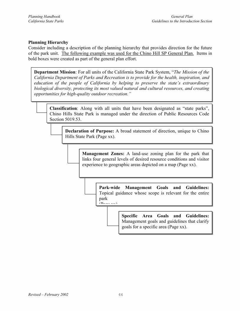
Planning Handbook General PlanCalifornia State Parks Guidelines to the Introduction Section
Revised – February 2002 46
Planning HierarchyConsider including a description of the planning hierarchy that provides direction for the futureof the park unit. The following example was used for the Chino Hill SP General Plan. Items inbold boxes were created as part of the general plan effort.
Specific Area Goals and Guidelines:Management goals and guidelines that clarifygoals for a specific area (Page xx).
Park-wide Management Goals and Guidelines:Topical guidance whose scope is relevant for the entirepark(Page xx)
Management Zones: A land-use zoning plan for the park thatlinks four general levels of desired resource conditions and visitorexperience to geographic areas depicted on a map (Page xx).
Declaration of Purpose: A broad statement of direction, unique to ChinoHills State Park (Page xx).
Classification: Along with all units that have been designated as “state parks”,Chino Hills State Park is managed under the direction of Public Resources CodeSection 5019.53.
Department Mission: For all units of the California State Park System, “The Mission of theCalifornia Department of Parks and Recreation is to provide for the health, inspiration, andeducation of the people of California by helping to preserve the state’s extraordinarybiological diversity, protecting its most valued natural and cultural resources, and creatingopportunities for high-quality outdoor recreation.”

Planning Handbook General PlanCalifornia State Parks Guidelines to Existing Conditions and Issues Section
Revised – February 2002 47
Guidelines to the Existing Conditions and Issues Section
INTRODUCTION
The Existing Conditions and Issues section of a general plan summarizes the status of resources,land uses, and park operations. It establishes the baseline from which proposed changes andpotential impacts can be evaluated, leading up to and determining what is proposed in the Plansection of the document which follows. It sets much of the context for the general plan. There arethree subsections: The Unit Summary, Planning Influences, and Issues/Analysis. The first twosubsections, Unit Summary and Planning Influences, emphasize factual data derived from the UnitData File and elsewhere. The third subsection, Issues/Analysis, extracts pertinent issues from theUnit Summary and Planning Influences. It discusses the relationship of those issues to one anotherand evaluates their relevance to the Plan section to come. Components of this section are organizedas follows:
UNIT SUMMARY• Existing Land Use• Significant Resource Values/ Constraints• Existing Facilities• Park Support
PLANNING INFLUENCES• Systemwide Planning• Regional Planning• Demographics• Public Concern
ISSUES / ANALYSIS
THE UNIT SUMMARY
The Unit Summary consists of three subordinate sections: Existing Land Use, Significant ResourceValues, and Existing Facilities. The Summary describes the unit only to the degree necessary tounderstand the general plan's long term management proposals. The discussion goes beyond theunit’s boundaries only if necessary to understand the land uses, resource values, and facilities incontext. The Unit Summary is based on information found in the Unit Data File.
Existing Land UseExisting Land Use provides a brief, but holistic description of the land and its uses. This sectionincludes the following information:
• Patterns of land use (discussed in broad categories of existing use, such as agriculture,natural open space, visitor use, support facilities, etc.).

Planning Handbook General PlanCalifornia State Parks Guidelines to Existing Conditions and Issues Section
Revised – February 2002 48
• An existing Land Use Pattern Map, where appropriate (this may include facilities)(Examples include: delineation of Subclassifications, Historic Districts, and Coastal Zone.)
Significant Resource Values/ConstraintsThis section discusses the resource values intrinsic to the unit. Only those resources that are deemed"significant" should be addressed in this section. "Significance" is determined if a resource:
• Is important to (or affects) the essential character of the unit, and contributes, in part, to itsstatewide significance, or
• Is regionally significant, is an important component of a Systemwide plan, contribution tothe preservation of regional or statewide biodiversity, or
• Is documented as significant on recognized preservation or protection lists, or otherwisedesignated with special status by a recognized authority. (Or, in the case of culturalresources, is deemed eligible for special designation).
As significant resource values are discussed, the justification of significance should be noted. Forexample, reference should be given that a certain animal is on the federal endangered species list.
The complexity and length of this section will vary, depending upon the unit size and classification.Sub-headings for the Significant Resources Values/Constraints section may include any of thefollowing, if appropriate:
Physical Resources Biotic Resources Cultural ResourcesTopography Plant Life Ethnographic BackgroundMeteorology Animal Life Archaeological SitesHydrology Aquatic Life Historical BackgroundGeology Marine Life Historical Features and LandscapesSoils Ecology Artifacts Original to Site
Paleontology Collections
Interpretive and Educational ResourcesVisitor Centers and Interpretive CentersMuseums and House MuseumsInterpretive KiosksInterpretive Trails, Roads, and Wayside exhibits, gardens, and other features.ExhibitsEvents and Programs (such as Living History, Demonstrations, re-enactment)Interpretive Programs (nature walks, guided nature walks)School Programs
Aesthetic ResourcesVisual resources and Scenic characteristicsNegative visual features and characteristicsViewshedsDesignated scenic areas or routesExternal views
Recreation Resources

Planning Handbook General PlanCalifornia State Parks Guidelines to Existing Conditions and Issues Section
Revised – February 2002 49
Recreation activitiesRecreation facilitiesPatterns and levels of useRecreation potential
Every sub-heading does not need to be included and individually addressed in every general plan. If, for example, there are few significant biotic resources at a small historic unit, then all significantplant and animal life could be grouped under a generic Biotic Resources section. If certain resourceinformation is determined to be “not significant”, it belongs in the UDF, where it can be accessed forfuture reference.
Significant resource values should be described briefly with sufficient detail to understand:
• What the value is.• Why it is considered significant.• Where it is located within the unit.
In addition, the following maps should be included if they are informative, depending, of course, onthe nature of the unit and the significance of the resource values:
NOTE: Mapping that depicts sensitive resource information, such as archaeological sites andendangered species locations, are considered “confidential” and shall not be placed in thegeneral plan or distributed to the general public. This information should be placed intoConfidential Appendices for the Unit Data File.
• Vegetation Map• Significant or Sensitive Plants/Plant Communities Map• Significant or Sensitive Wildlife Habitats• Significant or Sensitive Cultural Resources• Significant or Sensitive Paleontological Resources• Significant Geologic Features• Significant Geologic Hazards
Existing FacilitiesThe Existing Facilities section tells the reader what facilities currently exist in the unit. This isconveyed as simply as possible, using the following (if applicable):
• Facilities Map• Facilities Chart• Circulation Map• Text (which briefly describes the facilities)
Only the facilities that are considered significant or are part of a major issue, should be addressed indetail. In many cases, it is sufficient to note quantities (Facilities Chart) and location(Facilities/Circulation Maps). The following facilities are examples of those that may be included(as appropriate):

Planning Handbook General PlanCalifornia State Parks Guidelines to Existing Conditions and Issues Section
Revised – February 2002 50
Buildings Circulation UtilitiesVisitor/Interpretive Facility Roadways Sewer / Water TreatmentRestrooms Parking Storage TanksEntrance Stations Beach Access Power Lines (High Voltage)Concessions TrailsEmployee HousingOperations FacilitiesResearch/Library Facilities
Park SupportThis section describes the volunteers, cooperating associations, or founding organizations thatsupport the park unit. Types of support may include people assisting in resource management,land use planning, recreation, interpretation and education, fundraising, and operation of the parkunit. A brief description of the volunteer activities or park support functions should be includedin this section.
PLANNING INFLUENCES
Planning Influences is a subsection of the Existing Conditions and Issues section of a general plan. Itincludes a variety of influential factors to be considered when making planning decisions for a unit. These planning influences originate, for the most part, outside the unit boundaries and are importantin understanding the unit's land use, resources, and facilities in a larger context. These influencestend to fall into four broad categories: systemwide planning, regional planning, demographics, andpublic concerns.
Pertinent planning influences should be briefly described in terms of their influence on the unit. Information regarding each of these planning influences should be available in the Unit Data Fileunder appropriate categories. Often this information is contained in specific planning documents,which can be referred to by title and date of publication. Additional support material (includingmaps, graphics, photos, tables, graphs, etc.) is probably not necessary here and is best delegated toappendix material if needed for clarity. The level of detail may vary depending on unit characterand degree of influence, but should be kept to a minimum with reference made to the supportingdocument or plan.
To the degree to which it provides direction to the general planning effort, reference can also bemade to the planning actions that led to the establishment of the park. These include the project’sInitial Investigation, Feasibility Study, and the Acquisition E.I.R.
Systemwide PlanningSystemwide planning enhances the ability of the California Department of Parks and Recreation tofulfill its multi-faceted mission:
• Providing for the health, inspiration, and education of the people of California • Helping to preserve the state's most extraordinary biological diversity,• Protecting its most valued natural and cultural resources,

Planning Handbook General PlanCalifornia State Parks Guidelines to Existing Conditions and Issues Section
Revised – February 2002 51
• Creating opportunities for high-quality outdoor recreation.
By addressing concerns that cross unit and district boundaries, systemwide planning provides certainefficiencies, often reducing redundancies and maximizing the investment of staff time and associatedcosts. It also allows the Department creative opportunities that would otherwise not exist, such asthe development of a statewide hostel system or the interpretation of certain periods of Californiahistory (mining or the legacy of the CCCs, for example). Recreation planning, resourcemanagement, interpretation, and operations are four areas in which systemwide planning mayinfluence the general planning of a particular unit. Statewide programs and regulations of agencieslike the Department of Fish and Game (DFG), the California Coastal Commission, and the WaterQuality Control Board may also be incorporated into systemwide planning. Note that there may besome overlap with regional planning in these programs (take for example the state's NaturalCommunities Conservation Program [NCCP] Sub-area Plans, which are regional in nature), and itmay or may not be appropriate to discuss them in both contexts. Only those influences directly andspecifically applicable to a particular state unit should be referred to in the general plan document.
The following are examples of existing statewide or systemwide planning influences:
• Mission Statement (may be included elsewhere in document)• State Park System Plan• Statewide Recreation Plans• Systemwide Resource Directives• California Hostel Plan• California Underwater Park Plan• Statewide Trails Plan• Employee Housing Policies• Systemwide Policies Concerning Park Operations and Concessions• DAM/DOM• Access to Parks Guidelines• California Heritage Task Force• Natural Communities Conservation Program (DFG)• California Coastal Act• Public Resources Code
The following are examples of potential systemwide plans, which, if developed in the future, mayinfluence the general planning of a unit:
• Systemwide Interpretive Plans (Native American Heritage, Mining, Pacific Coast Highway, for example)
• Systemwide Resource Management Plans(May include plans which establish conservation priorities for oak woodlands, grasslands,redwood forests, or other natural communities)
• Statewide Plans Focused on Recreational Opportunities for Specific User Groups (Equestrian or Mountain Biking, for example)

Planning Handbook General PlanCalifornia State Parks Guidelines to Existing Conditions and Issues Section
Revised – February 2002 52
Regional PlanningRegional planning context will vary considerably across the State, depending on the character of thegeographic area (urban, rural, coastal, etc.), number of adjoining jurisdictions (cities, counties, otherstates, etc.), and complexity of regional planning overlays (such as those used for habitat ortransportation planning, national scenic or recreation areas, joint operating powers, etc.). It isimportant that these planning influences be understood so that the general plan for the unitanticipates and coordinates with regional planning issues. Refer to only those programs or planswhich specifically involve or influence the unit.
The following are examples of regional planning influences:
• Local Coastal Plans• Memorandums of Agreement or Understanding • General Plans of Local Jurisdictions
(land use, open space, conservation, park and recreation elements in particular)• Local Specific Development Plans• General Management Plans and Associated Documents
(such as NPS and USFS documents)• Regional Transportation/Circulation Plans
(especially plans for mass transit or freeway expansions if involving state park lands)• Regional Habitat Plans & Wildlife Corridors• Regional Water Conservation Plans • Watershed Management Plans• Regional Trail Plans• The Unit’s Role in the Context of Surrounding state park units
DemographicsExisting and projected demographic information can be useful in planning for a particular unit andshould be summarized in this section if there is a strong relationship to the unit and its existing orfuture patterns of visitor use. For example, if a unit is located within, or in close proximity to, alarge metropolitan area, local demographics may have a different bearing on the unit than if it islocated in a remote area. The economic or jobs/housing relationships between the unit and thesurrounding area may also be important to understand. If surveys have been taken at the unit, theyoften provide valuable information on where visitors originate; the type of user groups (equestrian,local surfers, international travelers, school groups, etc.) that frequent the unit; as well as travel time,length of stay, ethnicity, primary activities, and other valuable information.
The following data charts, survey results, diagrams, and demographic information should bereferenced in the text but found in the Unit Data File; they should not be included in the generalplan document.
Available census and economic information may include:• Population Trends & Projections• Demographic Diversity• Special Populations: Senior, Youth, Disabled, etc.

Planning Handbook General PlanCalifornia State Parks Guidelines to Existing Conditions and Issues Section
Revised – February 2002 53
• Local Market Analysis
Available information on visitor use patterns may include:• Attendance Figures (often more helpful if averaged over 10 years)• Seasonal Use Patterns• Target Populations • Travel Time, Length of Stay, etc.• Visitor Activities
Public CommentThe public and other agencies express their interests and concerns at various stages in the generalplanning process. User surveys, questionnaires, general correspondence, and public meetingsprovide opportunities for comment. Such comments are influential in the management andoperation of a unit and influence planning decisions as well. It may be helpful to include a briefsummary of significant comments in the general plan document, including any pertinent results fromthe Department’s Visitor Satisfaction Survey.
ISSUES / ANALYSIS
The Issues / Analysis section "sets the table" for The Plan; its purpose is to prepare the reader for theplan goals. It highlights and summarizes the important issues from the Unit Summary and from thePlanning Influences. These are the issues that will be addressed (and resolved) in the General Plan.Issues may be evaluated, prioritized, and briefly explained in terms of how one relates to another.
This section may state where issues originated, whether they were part of the original ProjectAgreement for the general plan assignment or whether they were identified during the publicinvolvement process. It may also discuss issues that will be addressed or resolved through otherplanning mechanisms, at other times. These other issues may require additional information to becollected for the UDF or addressed by future management planning. This is discussed further under“Issue Resolution” in the Area Goals and Guidelines section.
As part of issue resolution, the planning team will analyze the issues, evaluate how the issues relateto one another, and evaluate various goals that will resolve the issues. This analysis process is onlybriefly summarized in the general plan. A more complete recordation of the team’s analysis iscaptured in the Unit Data File. This section of a general plan does not explain, in detail, the logicalprogression from issue to issue resolution.

Planning Handbook General PlanCalifornia State Parks Guidelines to Existing Conditions and Issues Section
Revised – February 2002 54

Planning Handbook General PlanCalifornia State Parks Guidelines to the Plan Section
Revised – February 2002 55
Guidelines to The Plan Section
INTRODUCTION
Previous general plan sections describe the unit’s past and current management, and alsosummarize site conditions. The Plan section presents the vision and guidance for the futureof the unit. It states the basic philosophy or intent, and provides a management direction forthe unit.
The following is a basic outline for the PLAN section of the general plan document:
A. UNIT PURPOSE AND VISION• Unit Purpose• Unit Vision
B. GENERAL UNIT MANAGEMENT GOALS AND GUIDELINES• Classification • Management Zones• Resource Management and Protection• Unitwide Interpretation• Unitwide Visitor Services
C. AREA-SPECIFIC GOALS AND GUIDELINES• Statement of Management Intent• Specific Area Goals and Guidelines
UNIT PURPOSE AND VISION
The Unit Purpose and the Unit Vision may be combined into one statement, at the discretionof the planning team.
Unit Purpose The Unit Purpose is a statement or declaration of purpose for the unit, as determined by itsprime resource values and opportunities, and its relationship to the larger context of the StatePark System. This statement should clearly describe the unit's significance and value itrepresents to California and the State Park System. It may or may not be the same as theoriginal purpose. The following is an example of a Unit Purpose:
Example: The purpose of Short Trees State Park is to preserve and makeavailable to the people for their inspiration, enlightenment, and enjoyment, theoutstanding scenic features and natural values of the forested canyon, redwoodgroves, unique sandstone formations and the historically significant rustic park

Planning Handbook General PlanCalifornia State Parks Guidelines to the Plan Section
Revised – February 2002 56
structures developed by the Civilian Conservation Corps during the 1930’s. Theunit’s expansive natural area and rugged ridge terrain provides opportunities forprimitive trail recreation and sight-seeing, as well as day and overnight facilities,interpretation and education.
Unit Vision A Unit Vision describes the park in future years, when the Department has achieved its generalplan objectives and satisfied visitor expectations. The park’s vision should present guidingimages of what the unit may ultimately be like in both the physical and spiritual sense. Thesevisionary images will build upon the Spirit of Place and transcend today’s limiting factors to thehighest fulfillment of the unit purpose and ultimate visitor experience.
The unit vision can be written in either a present or future perspective. The two followingexamples illustrate how these differ, while still maintaining the same visionary message.
Present Perspective or Point of View: Short Trees State Park will be restored to a place ofspectacular scenic beauty--a natural area unencumbered by human habitation or visualintrusions. It will offer visitors of all ages and abilities access to the heart of the park wherethey can walk among unique geological formations, experience the magnificent presence ofancient redwoods, and hear the thunderous sound of water falling over steep canyon walls. It will be a place for visitors to seek personal renewal and gain inspiration from nature’spower and beauty.
Future Perspective or Point of View: Short Trees State Park is a place of spectacularscenic beauty--a natural area unencumbered by human habitation or visual intrusions. Itoffers visitors of all ages and abilities access to the heart of the park where they can walkamong unique geological formations, experience the magnificent presence of ancientredwoods, and hear the thunderous sound of water falling over steep canyon walls. It is aplace for visitors to seek personal renewal and gain inspiration from nature’s power andbeauty.
GENERAL UNIT MANAGEMENT GOALS AND GUIDELINES
Classification If applicable, include a proposal to reclassify the unit. Also, refer to the specific area guidelinesfor natural, cultural, or wilderness areas proposed for subclassifications. Explain why a changein the unit classification is necessary and what value this would have to future resourceprotection and/or opportunities for visitor use.
Management Zones Management zones are delineated on a unit-wide map. These zones are the first and mostgeneral attempt to define spatially the management scheme for a unit. The use of managementzones varies from general plan to general plan, depending on the need to describe managementgoals by area or show relationships between one area and another in terms of land use andmanagement strategies. They may be based on geographic relationships; resource values;

Planning Handbook General PlanCalifornia State Parks Guidelines to the Plan Section
Revised – February 2002 57
ecological parameters; management issues, goals, or objectives; types and intensities of land use;or visitor use and experiences. They may reflect special circumstances, such as a riparian zone,or clarify the management intent where conflicting uses may overlap. The use of managementzones may be more helpful when planning for larger park units and may not be appropriate forsmaller units. A Management Zone Matrix (see example in Appendix D) is a helpful tool tocommunicate and compare the distinct characteristics and requirements of each zone. Forexample, simple management zone schemes may include Natural/Cultural, Historic/Non-Historic, or Natural Open Space/Developed. More specific zones or even subzones, such as OldGrowth Redwoods, Entry Complex, Historic Town Core, Administrative Area, Scenic Area, orRecreation Area, may be designated when appropriate to reflect special circumstances forspecific park areas.
In units that are essentially an historic structure management zoning may, for example, be in theform of a floor plan that defines spatially the primary management scheme including zones fordifferent levels of restoration and use such as; historic restoration (controlled access), historicrehabilitation (mixed use), and adaptive use.
This section should also explain any proposed or expected changes from current land uses. Provide enough detail to assess what the cumulative impacts will be. Also in this section,describe the relationships with adjacent or nearby lands, public or private, and discuss thepotential impacts to significant resource values. Any discussion of non-state- owned land,whether as appropriate additions to the unit or in terms of joint use/management, may beincluded for long-range planning purposes only; it shall not represent a commitment foracquisition or imply a joint party agreement. Discussions of private-owned parcels outside ofthe unit boundaries are inappropriate and should be avoided. However, it is appropriate todiscuss in general the values of the surrounding lands to park issues and values.
Resource Management and ProtectionDevelop the unit-wide goals and management guidelines necessary to perpetuate the unit’simportant resource values and to overcome threats to those values. Rather than proposingspecific programs and projects, this section should state resource management intentions andprovide general guidance supportive of the unit’s natural, cultural, artifactual, scenic, andrecreational resources. Briefly describe the resource needs, management goals, and desiredconditions.
The following is an example of how this might be applied to a resource issue:
At Short Trees State Park there are significant resource concerns about the historicCivilian Conservation Corps (CCC) structures found throughout the unit. Some of thesestructures are considered to be excellent examples of CCC architecture andcraftsmanship, while others are in poor condition, impede park functions, or offer littlevalue to the park user. Most structures are in use and receive regular maintenance, butsome buildings have been vacant for years and would require substantial rehabilitationin order to be occupied and further protected. Original artifacts from the CCCstructures include: architectural plans, a set of original tools used in building thehistoric structures, and the original diary of one CCC worker.

Planning Handbook General PlanCalifornia State Parks Guidelines to the Plan Section
Revised – February 2002 58
• Management of the CCC structures will be undertaken with the intent of preservingstructures, and with the broader goal of preserving the historic record. Documentationand understanding of all CCC structures will exist prior to any removal or modification.
• Future management of CCC features will be based on a clear understanding of each
feature and its importance in meeting historic preservation, park experience, andinterpretive needs. Determining which buildings and other structures will be removed,stabilized, restored, or modified for adaptive reuse is essential in meeting this goal.
• Management of original CCC artifacts found in the park will be carried out with theintent to preserve evidence of the human effort and creativity that resulted in theconstruction of these significant historic structures. These objects will be preserved,documented and made available to scholars for further research.
For State Historic Parks, it may be necessary to complete building surveys, present thehistoric period and determine whether a structure is appropriate for adaptive use in general,consistent with long term goals for the unit. This detail will vary from unit to unit and isfurther guided by the general plan project agreement.
Unit-wide Interpretation
Interpretation deepens the park experience, providing lasting benefits not only for individuals,but also society in general. Through interpretive services, visitors are introduced to the intrinsicvalues of each park. The unit-wide interpretation section makes a case for the most significantconcepts that are to be presented through various media to the public.
Unit-wide interpretation should describe how this unit relates to others within the State ParkSystem, as well as to nearby local, county, and regional museums, historical sites and parks. Insome instances the connection to other facilities should be further clarified.
Themes are critical for establishing the overall interpretive direction and tone and they implydesired outcomes for visitor’ attitudes and perspectives. The unifying theme provides overallfocus to the unit’s interpretive development. It must relate to the resources, the mission of theunit, and visitors’ interests. The most essential ideas of a unifying theme are presented throughthe development of primary and supporting interpretive themes. Defining the point of view to begiven to the interpretation of resources will help to guide many subsequent land use andmanagement decisions.
Describe a single unifying theme with primary and supporting themes that will create aconceptual framework for the unit. A secondary theme may also be included in this section. Itmay offer a valuable concept that is significant to the unit, like sidebars or footnotes in a book,but does not relate to the overall unifying and primary themes. Identify the primary interpretiveperiod(s) if this is a state historic park, or if there are significant historic resources within a unit

Planning Handbook General PlanCalifornia State Parks Guidelines to the Plan Section
Revised – February 2002 59
designated by a different classification. This information will direct future decisions in thedevelopment of management and project plans.
Express unit-wide interpretive goals and guidelines clearly. What kind of physical andemotional involvement do you want visitors to have with the park’s resources? Goals andguidelines become the basis for program policies. Examples: Visitors will be able to experiencethe park using all of their senses. Or, seasonally changing interpretive programs will be offeredto visitors. Or, visitors will understand the valuable role the CCC has played in making thepark’s resources accessible to the public. Define the Department’s intentions as goals andguidelines for increasing the public’s understanding and appreciation of the unit’s significantnatural, cultural, scenic, and recreational resources.
Remember, interpretation may be used to help gain public support for California State Parks, andthe specific management goals of the unit. Interpretation can play a major role in raisingawareness of visitor actions that can help to protect a cultural preserve or a natural preserve orother resources within a unit. Management issues will vary from plan to plan.
Once interpretive goals and guidelines are established, work may begin on the preparation ofinterpretive plans, expanding upon the interpretive themes, and detailing the methods, media andprograms for a unit. These typically are not part of the General Plan. Specific projectinterpretive plans, exhibit plans and furnishing plans, focused on more detailed interpretation ofthe unit’s resources may follow in future documents.
Example Unit-Wide Interpretation
Short Trees State Park contains old growth redwood groves that have internationalsignificance. Unit-wide interpretation will include the significance of the redwoodgroves, instilling in the visitors the sense of place and the need to preserve and protectthis irreplaceable resource. The Civilian Conservation Corps played a pivotal role indevelopment of the park, and within the historic area of the park, built the campfirecenter, stoves, tables and the cabanas. The identification of these structures to thevisitors will enable the visitors to learn the importance of preserving and protecting thecultural resources of the park.
Involving the visitor in assisting us in meeting the resource management andprotection goals will be important to our success. Interpreting the natural flora andfauna, the cultural elements of the park and the need for preserving these features mustbe the primary goal for interpretive efforts. The broad, overall goal of interpretiveprogramming will be to allow the visitors to have experiences that will develop anappreciation for the natural and cultural features of Short Trees State Park.
The unifying theme of the Short Trees State Park provides a conceptual focus forinterpretive exhibits and programs for the entire unit. The unifying theme also sets theoverall interpretive tone and direction, and implies the desired result interpretationshould have on visitors’ attitudes and perspectives. The unifying theme is presentedthrough interpretation of primary and secondary themes.
Planning Handbook General PlanCalifornia State Parks Guidelines to the Plan Section
Revised – February 2002 60
Unifying Theme: Explore how natural forces, plants, animals and people continuallychange this fragile and endangered habitat of Old Growth Redwoods.
Primary Theme: Making a Living in a Redwood Forest: Timber cutting, milling, andcoastal shipping from doghole ports were the beginnings of may coastal towns, shapinggenerations of their citizens.
Primary Theme: Tough times yield preservation: When America was in the grips of adepression, multitudes of individuals worked with the Civilian Conservation Corps topreserve and protect parks through their labor.
Primary Theme: Discover the Redwood Groves: The colorful and varied life forms of theredwood grove have developed fascinating ways of surviving natural challenges, but theycan’t survive our carelessness.
Secondary Theme: Discover Coastal Forests: Whether growing or decaying, nativeconifers support a rich variety of wildlife.
Supporting Theme: Observing Safety: If you are at a park or at home, the power ofobservation will keep you safe.
Unitwide Role of Collections
A statement of the role of collections in the unit should be included. This statement describeswhether there will be a collection maintained at the unit, and if so, what kinds of objects the unitwould collect and maintain, and why. A broader, more fully developed Scope of CollectionsStatement should be developed separately as a management plan, and will be revisedperiodically to reflect new knowledge or program needs. The statement of the role of collectionscontained within the general plan will address the fundamental questions of whether the unit willmaintain and/or acquire collections, and what broad or specific subject areas these collectionswill cover. Rather than proposing specific acquisitions, the role of collections is a description ofwhat is to be collected and preserved for the unit as it relates to the unit purpose, vision, existingresources, and interpretive element. In addition to consideration of “unit specific” needs,thought must be given to the role the collection will play on a local, regional, statewide orinternational level.
Example:Role of Collections for the Big Bar Ranch SHP
Natural and cultural material and object collections at Big Bar Ranch SHP will have a specificconnection to the natural and cultural history of the park, or provide support for interpretivethemes and programs. Archaeological and paleontological materials, natural history specimensof park flora and fauna, and historic objects such as furnishings, equipment, or personal itemsassociated with the park are all potential collection items at Big Bar Ranch SHP. Historicobject collections will include those of the ranching period up to the year 1950.
Planning Handbook General PlanCalifornia State Parks Guidelines to the Plan Section
Revised – February 2002 61
• Acquisitions of ranching era artifacts will have a local historical association to the BigBar Ranch, or other ranching activities within or near Big Bar Ranch SHP.
• Natural history specimens will be preserved when necessary to document the naturalhistory of the park.
• Architectural elements and other materials original to the park or used in its historicstructures will be preserved when necessary to document the history of the park and itshistoric structures.
• Archeological materials found on site will be preserved, and may be stored at theCultural Resource Division’s headquarters facility if appropriate space is not availableat the park.
• The Department will establish safe and secure spaces for storage and display of parkcollections. Policies and procedures for management of collections as outlined in theDepartment Operations Manual (DOM) Chapter 2000 will be followed.
Unitwide Visitor Use and OpportunitiesThis section presents the broad goals and guidelines that are developed for guiding unitwidevisitor use and services. It addresses all types of services and related planning issues that are nottied to a specific geographic area of the unit. These guidelines:
• direct management as to the appropriate recreation types and levels of public use thatmay be accommodated in the unit;
• describe management goals for providing unitwide services to the public through parkconcessions, or by other outside providers;
• indicate the direction for park operational services; and • describe for the unit as a whole, the desired concept for the way visitors would enter
and move through the unit (the park experience).
The range of planning issues and desired unitwide services will vary from plan to plan. Servicesand issues that require discussion of specific facilities are more appropriately addressed in thespecific area guidelines.

Planning Handbook General PlanCalifornia State Parks Guidelines to the Plan Section
Revised – February 2002 62
VISITOR CAPACITY OR RECREATION CARRYING CAPACITY
This section should include discussions of unit carrying capacity and/or limits of acceptableenvironmental change. These concepts are intended to guide the appropriate levels of unitwidemanagement, development, and use, so that management goals can be achieved and the unitvision can be realized.
Definition: Recreation carrying capacity can be defined as a prescribed number and type ofvisitors that an area will accommodate given the desired natural/cultural resource conditions,visitor experiences, and management program.
In both state and national parks, increasing rates for certain recreation activities promotedmanagement concerns that use levels may be causing environmental damage or reducing thesatisfaction of users. The concept of carrying capacity has been used in recreation planning as atheoretical indication of an upper limit in allowable use levels.
For State Park System General Plans, the Public Resources Code currently provides thefollowing requirements:
PRC 5019.5. Before any park or recreational area developmental plan is made, theDepartment shall cause to be made a land carrying capacity survey of the proposed parkor recreational area, including in such survey such factors as soil, moisture, and naturalcover.
PRC 5001.96. Attendance at state park system units shall be held within limits establishedby carrying capacity determined in accordance with Section 5019.5.
In application, previous attempts to establish land carrying capacity limits in general plans havenot produced the desired outcome for protecting resources, or were challenged on the basis ofinadequate analysis of resource conditions and monitoring and assessment of the visitor useimpacts on these resources. Other State and National Park agencies have developed moresuccessful models for doing these evaluations, which substantiates the need for either setting uselimits or taking other more appropriate management actions.
For general plans, project teams should evaluate the level of visitor use in relationship to itspotential effect on natural, cultural, aesthetic, and recreational resources, as well as overallvisitor experience. The plan should describe the desired future conditions of the unit’s natural,cultural, aesthetic, and recreational resources, as well as the desired visitor experience for thatpark. Goals and guidelines should be established in the plan for visitor use management that willlead to these desired future conditions. Carrying capacity (use limits) may be established for aunit (or individual areas) at the time when more detailed information is made available; moreappropriately during the preparation of management plans.

Planning Handbook General PlanCalifornia State Parks Guidelines to the Plan Section
Revised – February 2002 63
An example discussion of unitwide visitor use management might be as follows:
The redwoods of this unit represent the southern most stands of redwoods along the coastof North America and are located adjacent to Coast Highway 1. Along with theDepartment’s goal to protect this significant resource, it is management’s intent toprovide for appropriate visitor access. The visitor experience within the redwoodcorridor and related groves will be one of discovery, variety, and solitude. The goal ofmanagement will be to balance the needs of public access with maintaining the quality ofthe natural experience. The entry and sequence of travel through this unit is importantand will present the redwoods as the focal point of the unit. Trail loops should be ofvarious lengths and allow the user contact with the many environs of the redwoodcommunity. Pedestrians-use areas will be separate from traffic areas, and provisions willbe made for the less mobile visitors to circulate appropriate portions of the redwoodsand receive interpretative information.
The primary goal for future circulation and access planning and design is to provideopportunities for the majority of the visitors to experience the redwoods without intrusionfrom nearby visitor activities. Detailed design and desired trail capacities will bedetermined through future management plans, subject to environmental review prior toactual development. Trails and redwood management plans will determine an acceptablevisitor capacity of the individual redwood areas.
The current vehicle circulation throughout this unit is very confusing to the park visitorand contributes to the vehicle congestion in the prime resource area. Therefore, themain park road should clearly and safely guide the visitor from the unit entry to theprimary park destination (Tall Trees and Falls Overlook). This road should allow for apanoramic view of the unit’s scenic resources on an alignment that complements the landcontours.
Park management will balance the need for visitor services (food, recreational supplies,and rentals) with the goal of maintaining the unit’s naturalness free of man-madestructures and clutter. Management will provide adequate visitor services whileminimizing the number of buildings and/or reduce their visual impact on the visitor’sexperience of the unit’s primary resources.
AREA GOALS AND GUIDELINES
This section presents the goals and guidelines applicable to specific management zones or planning areas (refer to the management zone map). These goals and guidelines should refinethe management intentions for a specific area of the unit and clarify, if necessary, how unitwidegoals will be applied. This section should be structured by management zones or planning areas.
Statement of Management Intent

Planning Handbook General PlanCalifornia State Parks Guidelines to the Plan Section
Revised – February 2002 64
A general statement of management intent should be presented for specific park areas when it isnecessary to identify the area’s special significance or its relationship to the overall unit vision (amini-vision or statement of purpose for this area). Not all zones will require this statement,especially if the zone supports the same purpose stated for the unit as a whole.
The following example describes the management intent for an area:
The Little Creek Area is a scenic natural area that clearly demonstrates the re-establishment of the redwood community after a century of commercial overuse. Visitors should gain an understanding of the extensive logging activities associatedwith the Mill site operation and appreciate the joint reclamation efforts of nature and park management that are taking place in thesurrounding forest. Resource management efforts will support the recovery of thisimportant natural habitat.
Specific Area Goals and GuidelinesSpecific areas in the unit are distinguished by their resource values and use. These may requiremanagement goals or guidelines that are more specific to an individual area, or that clarify theapplication of broader unitwide goals in the major program areas, or that resolve how apparentlyconflicting management goals are integrated.
The desired format for this section is to integrate the resource management, interpretation, visitorservices, and recreational use for a specific area. If possible, describe how the variouscomponents relate to one another.
A Specific Area Goals and Guidelines section could integrate the following components:
Resource Management - Consider additional resource goals and guidelines for specificareas where the broader unitwide guidelines may need clarification as to intent or requiresupplemental guidance for application. This discussion may also elaborate on the need forgreater flexibility in the application of a unitwide guideline because of special conditionsor prescribed mitigation.
Interpretation - Consider additional interpretive goals and guidelines when needed toclarify how the area interpretation relates to and supports the unitwide interpretive goals. Also discuss interpretation where it integrates with, or enhances, other management goalsfor resources, visitor services, or visitor experiences.
Visitor Services and Facility Development - The general scope and intent for desiredvisitor services and facility development within a specific area of the unit could bediscussed in this section. Describe an ideal condition, standard, or level of visitor servicefor this area. State how this differs from existing conditions and how it fulfills orcomplements the unitwide goals. Describe the level of acceptable change that would beallowed to maintain the balance between the proposed use area and their respectiveresources.
Planning Handbook General PlanCalifornia State Parks Guidelines to the Plan Section
Revised – February 2002 65
Collections - Collections play a vital role in Resource Management, Interpretation, andVisitor Services. Consider additional areas where collections should play a role or notplay a role within the operation of the unit. It is just as important to identify where we donot want to go with our collections as it is where we want to go. Describe and discuss howcollections will assist the other areas and their respective resources.
Priorities, relationships, and future actions - Usually, general plans should not includespecific proposals for implementation, therefore will not need prioritizing. However, whenfuture actions directed by the general plan may affect each other, it may be valuable todescribe the relationship between them and the necessary or desired sequential orsubsequent actions that should occur. As well it may be necessary in some units to definethe portion of an area that any one Area Development Plan should cover.
Recreation - Describe the goals and guidelines for public activities that are desirable for anarea. Identify broad types of high-quality outdoor recreation that are appropriate. Considerguidelines that would protect or enhance existing recreation experiences. Developguidelines that would eliminate recreation conflicts with other core program areas, or toreduce those conflicts to acceptable levels.
Each area is unique, so one area may require goals and guidelines for resource management butnot for visitor use or interpretation. Other areas may involve planning issues that require goalsand guidelines for visitor use in addition to resource management and interpretation. Theseshould then be followed by goals or guidelines that integrate the major program areas to providegreater clarification of management intent or to resolve overlap or conflict between goals.
The following narratives are examples of the Goals and Guidelines for two Specific Areas:
Little Creek Area
The Little Creek Area is the first visitor stop in the unit. It sets the first impression forthe unit and should provide a clear orientation to available park facilities. Theplacement and scale of facilities in the Little Creek Area is critical to the goal ofproviding a quality visitor experience. Visitor facilities should enhance natural andscenic resource values, provide focus on the interpretation of cultural sites, and increasepark orientation, without becoming attractions unto themselves.
Facility designs at this area should reflect an architectural aesthetic that will complimentthe “park-rustic” design style. Facilities and site plans should include the necessarycomponents for public use and interpretation.
Trails will be provided in a manner that balances resource protection goals with qualityrecreation and visitor experience goals including access to historic features.
Interpretation will be used as the primary means of protecting resources in the areathrough developing an increased visitor sensitivity and appreciation.
Planning Handbook General PlanCalifornia State Parks Guidelines to the Plan Section
Revised – February 2002 66
To support the primary interpretive theme of the unit, the resources of the Little CreekArea should be interpreted to show how the people continually used, influenced change,and eventually restored this fragile area of the unit.
Primary resources in this area that support the unit wide theme include: Evidence ofhistoric human activities including 19th century logging and tan oak harvesting, and theCCC structures.
The collection of original artifacts will be managed to preserve this evidence forresearch and interpretation.
The red alder riparian forest characteristically has a high percentage of snags and treefailures during winter months requiring continual preventive management in visitor useareas. The red alder riparian forest will be managed for its long term
stability in relationship to the recreational use areas. If continued resource impacts aredetermined significant and mitigation is not possible in a specific site, then overnight usewill be removed and the site restored to as natural a condition as possible.
Stream bank protection is required in the campground to protect visitor facilities. Thisaction is in conflict with the general application of a unitwide guideline. In this facilityarea limited modification of the natural conditions is appropriate, coupled with thevaluation and monitoring of possible effects on downstream habitat.
The intent of management is to maintain the quality of the riparian area of Little Creekthat is impacted by logging activities outside the unit. These impacts will continue tothreaten or damage park values. The Department will take a proactive role in protectingthe area from damaging impacts including participation in local and regional planningdecisions, and by developing watershed restoration to correct, as possible, impacts thathave degraded natural values.
Mill Pond Area
The Mill Pond Area is unknown to most visitors and the mill is presently in a state ofdecay. With substantial restoration of both cultural and natural features, this area hasgreat potential for fulfilling the unitwide goals of both increasing interpretiveopportunities about historic logging and enhancing wetland habitats. Hiking andinterpretive trails are appropriate for this area if potential impacts to sensitive plant andwildlife habitats can be avoided.
Specific guidelines for facilities, if expressed, should be as visitor opportunities and experiencesthat are intended to be provided, or to resolve a conflict or clarify how goals will be integrated orapplied in an area.
For areas where planning issues develop around future development and the potential conflictwith sensitive resources, it may be desirable to include a relationship diagram, or conceptual planfor the area. A bubble diagram, or description that conveys the desired outcome should be

Planning Handbook General PlanCalifornia State Parks Guidelines to the Plan Section
Revised – February 2002 67
sufficient. Generally, a detailed site analysis would not be included and the development of adesign plan is not desirable at this stage of planning. It will be accomplished at a managementplan stage of planning following the general plan.
When the general plan proposes an area for a natural or cultural preserve, the purpose of thissubclassification should be discussed in detail. Describe the significance and the integrity ofresources, the consequences of the specific subclassification for management and use of the area,and include a clear description of the boundary. Note that subclassifications require approval bythe State Park and Recreation Commission through a resolution separate from general planapproval. This action can occur outside the general plan process.
ISSUE RESOLUTION
Each general plan project may identify a number of issues and planning efforts that requireattention beyond the scope a general plan. Funding and staffing limitations may restrict theselection of issues and studies the Department is able to immediately address and require that theDepartment set priorities. Many goals and guidelines within a general plan will providedirection for each issue, with some recommending future planning efforts such as managementplans and studies.
The general planning effort will focus on the primary issues identified in the Project Agreement,as described in the Issues and Analysis section of the general plan and those that arise duringplan preparation. The “Issue Resolution” section of the general plan should identify all planningissues and required studies that are recommended throughout the general plan. This section willassist Department staff in setting priorities for future management plans, studies and planningefforts related to unresolved issues, but is not intended to restrict management efforts on lowerpriority issues or future planning needs.
The following is an example of how this section of the general plan can recommend theresolution of issues and undertaking of future planning efforts:
This general planning process has identified additional issues and planning efforts thatthe Department should consider and address in the unit’s on-going management anddevelopment programs. These include the following issues and actions:
Biocorridors and Core Habitat Areas – Protect and enhance the park’s wildlife habitatlinkages with nearby wildlife habitat areas through coordination with local, state, andfederal agencies, and acquisition and restoration projects. Additional resourceinventories and mapping are desirable for regional management and protection of thesehabitats.
Park Access Points – Resolve park entrance road and boundary access problemsthrough detailed site planning, coordination with local agencies, and facilityimplementation. Some solutions to access problems may require additional propertyacquisitions.
Planning Handbook General PlanCalifornia State Parks Guidelines to the Plan Section
Revised – February 2002 68
Appropriate Recreational Use – Following the general plan’s scope and intent, futurestudies are needed for site specific traffic analysis at the West Gate to select the finalaccess alternative from those identified in the general plan. Priority of development atthe Village Site will be dependent on DPR participation in coordinated communityplanning. Statewide studies presently under way are necessary to assist in settingpriorities for the recreation options allowed for in this plan. Interpretive influence - Interpretation plays a significant role in the resolution of thesegeneral plan issues. The general plan recommends that the educational programs,interpretive planning, design, and facility implementation be accomplished with theresolution of the above issues.
Additional resource management efforts - The general plan recommends that thefollowing planning efforts and studies be undertaken. See the referenced page numberfor a complete description of the guideline:
1. Collect resource information and monitor the health and function of core areas andwildlife habitat linkages (Page XX)
2. Develop Management plans, studies and updates to the park’s Unit Data File asnecessary to meet vegetation management guidelines (Page XX)
3. Collect information regarding the presence of sensitive species within, movementthrough, and uses of the park (Page XX)

Planning Handbook General PlanCalifornia State Parks Guidelines to the Environmental Section
Revised – February 2002 69
Guidelines to the Environmental Analysis Section
INTRODUCTION
The Environmental Analysis Section of a general plan contains the information necessary tosatisfy the requirements of the California Environmental Quality Act (CEQA). The general plancan be used as an Environmental Impact Report (EIR), and no separate EIR is required if thegeneral plan addresses all of the points required in an EIR, and the general plan includes aspecial section identifying where each required point is addressed (CEQA Guidelines Section15166). The Environmental Analysis Section will meet this requirement for a special section,and will include discussion of any required issues not addressed in other sections of the generalplan.
In some cases, the Environmental Impact Report (EIR) being prepared for a general plan may bepublished in a separate document, with adequate reference to the general plan. This instancemay occur when the general plan is being prepared through a consultant contract or when theEIR is contracted separately for a general plan project.
Whatever method is used to prepare the CEQA document, CEQA issues must be considered andintegrated early in the planning process, particularly at the Project Agreement stage when workscope is developed, which should include the environmental impact work that is going to berequired for the project. An Environmental Checklist is prepared to identify the CEQA issues tobe addressed in the EIR.
General plans will take advantage of the CEQA concept of tiering. According to CEQAGuidelines Section 15152 (1997-98 proposed revisions):
“Tiering” refers to using the analysis of general matters contained in a broader EIR (such asone prepared for a general plan or policy statement) with later EIRs and negative declarationsof narrower projects; incorporating by reference the general discussions from the broaderEIR; and concentrating the later EIR or negative declaration solely on the issues specific tothe later project.
The environmental review in a general plan is considered a “first tier” EIR. The EnvironmentalSection will consider the broad environmental issues that arise from the general plan. The levelof detail in the first tier EIR should be commensurate with the level of detail in a general plan. The EIR must analyze all “reasonably foreseeable significant environmental effects” of adoptinga general plan (including cumulative impacts, commensurate with the level of detail beingproposed) [CEQA Guidelines Section 15152 (1997-98 proposed revisions)], but need notconsider issues that are not yet ripe for decision. Subsequent environmental documents withmore detailed site specific information and analysis would be prepared for proposeddevelopments, such as buildings, campgrounds, and trails. Analysis that cannot be made withoutsite specific and project specific information may be deferred from the general plan until laterenvironmental documents on the proposed projects.

Planning Handbook General PlanCalifornia State Parks Guidelines to the Environmental Analysis Section
Revised – February 2002 70
The content in the Environmental Analysis Section, and the environmental analysis in othersections, will vary with the scope, complexity, and controversy involved in a general plan. Thespecific items that must be included will change with subsequent legislative changes to CEQA,and revisions to the CEQA Guidelines. Always consult with the latest versions of CEQA andthe CEQA Guidelines for any revisions to this information.
For a Draft EIR the following issues must be addressed, either in the Environmental Section, orthrough reference to their location in other general plan sections.
A. TABLE OF CONTENTS OR INDEXB. SUMMARYC. PROJECT DESCRIPTIOND. ENVIRONMENTAL SETTINGE. ENVIRONMENTAL IMPACT
1. Significant Environmental Effects2. Unavoidable Significant Environmental Effects3. Significant Irreversible Environmental Changes4. Growth-Inducing Impacts5. Mitigation Measures Proposed to Minimize Significant Effects6. Alternatives to the Proposed Action7. The Relationship Between Local Short-Term Uses and Long-Term Productivity
(in joint EIR/EIS)8. Cumulative Impacts9. Effects Found Not to Be Significant
F. ORGANIZATIONS AND PERSONS CONSULTEDG. COMMENTS RECEIVED
1. Organizations and Persons Commenting2. Responses to Comments
H. INFORMATION ADDED TO DRAFT TABLE OF CONTENTS OR INDEX
Environmental documents are meant to inform the public of the environmental impacts ofprojects and decisions. CEQA requires a table of contents or index so the public can findrelevant information. The Environmental Analysis Section may reference a table of contents orindex found in the general plan.
SUMMARY
The Environmental Analysis Section should contain a brief summary of the proposed actions andtheir consequences. In clear, simple language the narrative will include:
• Significant environmental effects, with mitigation measures and alternatives to reduceor avoid the effects

Planning Handbook General PlanCalifornia State Parks Guidelines to the Environmental Analysis Section
Revised – February 2002 71
• Areas of known controversy, including issues raised by agencies and the public• Environmental issues to be resolved
PROJECT DESCRIPTION
The CEQA Guidelines require the following information, either within the EnvironmentalSection, or within other sections of a general plan:
• Location map• Regional map• Statement of plan objectives• Description of plan’s technical, economic, and environmental characteristics• Statement of intended uses of EIR
• List of agencies expected to use the EIR in decision-making• List of approvals for which EIR will be used
ENVIRONMENTAL SETTING
The Environmental Analysis Section will reference other sections of a general plan that describethe local and regional environment in the vicinity of the park unit. (See Guidelines to theExisting Conditions and Issues Section.) Call special attention to:
• Rare or unique environmental resources that would be affected by the general plan• Inconsistencies between the proposed general plan and other applicable general and
regional plans, including:• Air Quality Management Plan (or State Implementation Plan)• Waste treatment and water quality control plans• Regional transportation plans• Regional housing allocation plans• Regional land use plans
• Coastal Zone• Lake Tahoe Basin• San Francisco Bay• Santa Monica Mountains
ENVIRONMENTAL IMPACT
The Environmental Analysis Section will evaluate the impact of the proposed general plan on theenvironment. The following subjects should be discussed in separate paragraphs. If each issueis not discussed separately, the Environmental Section will include a table showing where eachsubject is addressed.
1. Significant Environmental Effects Discuss all physical changes that cause significant impacts to the environment:
• Resources involved

Planning Handbook General PlanCalifornia State Parks Guidelines to the Environmental Analysis Section
Revised – February 2002 72
• Direct and indirect effects• Short-term and long-term effects
2. Unavoidable Significant Environmental Effects
Address all significant impacts that cannot be avoided, or that can be mitigated but notreduced to a level of insignificance.
3. Significant Irreversible Environmental Changes
This discussion is specifically required for EIRs on public agency plans, and on projectssubject to NEPA. Items to consider include:
• Use of non-renewable resources• Impacts that commit future generations• Irreversible damage• Irretrievable commitments of resources
4. Growth-Inducing Impacts
Include this discussion if a general plan fosters economic or population growth directly orindirectly, or could enable or encourage other activities that could significantly affect theenvironment
5. Mitigation Measures Proposed to Minimize Significant Effects
Present and evaluate measures that could minimize significant adverse impacts for eachsignificant environmental effect identified in the EIR.
6. Alternatives to the Proposed Action
Discuss a range of reasonable alternatives that would feasibly attain most of the basicobjectives of the plan but would avoid or substantially lessen any significant environmentalimpacts.
7. The Relationship Between Local Short-Term Uses and Long-Term Productivity (in
joint EIR/EIS) This discussion is no longer required by CEQA; but is still required by the NationalEnvironmental Policy Act (NEPA). If a general plan is subject to NEPA (e.g., a joint projectwith a federal agency), the Environmental Section must address impacts that narrow therange of beneficial uses of the environment or pose long-term risks to health or safety.
8. Cumulative Impacts
If the environmental analysis indicates that there are significant cumulative impacts from ageneral plan, the Environmental Section should include:
• a list of past, present and reasonably anticipated future projects producing related orcumulative impacts, or
• a summary of projections in other planning documents designed to evaluate regionalconditions
9. Effects Found Not to Be Significant

Planning Handbook General PlanCalifornia State Parks Guidelines to the Environmental Analysis Section
Revised – February 2002 73
Discuss the reasons that possible significant effects were determined not to be significant andwere therefore not addressed in detail.
ORGANIZATIONS AND PERSONS CONSULTED
Identify all agencies, organizations, and individuals consulted in preparing the draft EIR and thepersons, agency, or firm preparing the draft EIR
COMMENTS RECEIVED
1. Organizations and Persons CommentingAs a part of the public review process required by the California Environmental Quality Act,the Preliminary General Plan/ Draft EIR document is made available for public review andcomment for a minimum of 45 days. For this review process, the Governor’s Office ofPlanning and Research (State Clearinghouse) assigns a unique number to each general plan. The planning documents are sent to a list of individuals, agencies, and organizations asrequired by State Clearinghouse and determined by the Department.
2. Responses to commentsAt the close of the review period, all public comments that are received in writing, commentsfrom individuals, organizations, and other public agencies, are evaluated by the Department’splanning staff, which prepares written responses. Staff responses include issue justificationor clarification for the reader, or may indicate non-significant plan changes to be made in theFinal General Plan document. These comments and responses are sent to the people whocommented, and also to the California Park and Recreation Commission for their review aspart of the process of evaluating and approving a general plan and final EIR document.
Upon the Commission’s approval of the plan, these public comments and staff responses areusually published as a supplemental CEQA document separate from the general plan. This isdesirable in order to keep the overall size of the document within reasonable limits. However, ifthe numbers of public comments and Department responses are minimal, then they may beincluded in the Final General Plan document.
INFORMATION ADDED TO DRAFT
Discuss any other information added by State Parks after review of the draft EIR.

Planning Handbook General PlanCalifornia State Parks Guidelines to the Environmental Analysis Section
Revised – February 2002 74

Planning Handbook General PlanCalifornia State Parks Editing, Graphics, and Printing Guidelines
Revised – February 2002 75
Editing, Graphics, and Printing Guidelines
GENERAL PLAN PUBLICATION FORMAT
Cover:Use color photo, ink, and paper of choice. Consider recycled paper when possible. Texturedpaper can be used. Generally, colored covers and special graphics are costly and should beconsidered only for printing the Final General Plan. Black and white covers are consideredappropriate for draft general plans, unless authorized for color due to Department or Agencydistribution requirements.
Cover shall display official State Park logo. Refer to current Departmentguidelines for proper use of the official bear logo, a registered trademark.
Binding: Use perfect (wrap-around) binding, with document title, for final printing.
Copyright:This publication is intellectual property that is to be protected. Therefore, please indicatecopyright restrictions for any reproduction of text, maps, and photos. A copyright notice mustbe attached to any document or item that we wish to maintain intellectual property rights.
Staff Credits: Provide credits to staff and persons responsible for preparation of the general plan document. Use civil service titles, with level of responsibility (e.g. Associate). Provide special thanks tokey individuals, groups, or advisory committee members, who provided valuable assistance inthe planning process.
Contacts for Information:Provide office mailing address, phone and Fax numbers of locations for questions and generalplan information.
Source for Additional Copies:Provide source locations (on inside back cover) to obtain additional copies of the general plandocument. Refer to the availability of the document at depository libraries (indicate state librarywith address and phone). Indicate purchase cost, plus postage and handling. Also reference tothe State Park’s website for opportunities to read copies of this and other planning documentsprepared by the Department.
Reference to Supplemental Documents:Use standard methods to reference related published documents that were used in this planningeffort and could be located elsewhere (such as CEQA comments and staff responses, resourceinventories, research papers and other studies).
Planning Handbook General PlanCalifornia State Parks Editing, Graphics, and Printing Guidelines
Revised – February 2002 76
Commission Resolution:In the final printing, place the Commission’s resolution(s) approving of the general plan, and anysubclassifications, at the front of the document (located before the title page and not mentionedin table of contents).
General Plans and Amendments:Print a separate document for each unit general plan and general plan amendment. Theamendment will likely be too thin for a perfect binding. If the general plan is to be reprinted, anamendment could be placed under same cover with the general plan, so long as the body of theamendment remains together and its integrity is maintained (one document inside another).
EDITING
The editors of general plan documents look for clarity, consistency, and emphasis. Brevity isprized, but not at the expense of clarity. Put words in their best order. Standard English is thegeneral expectation, but exceptions are allowed. Adherence to a formal style manual is notrequired. Use of the grammar checker in your word processing software is recommended.
LAYOUT
Front Cover The front cover layout of a general plan includes the full title of the report, such as “McArthur-Burney Falls Memorial State Preliminary General Plan.” The Department logo is included. The“Final” general plan includes the Commission resolution inside the front cover. TheCommission approval date belongs on the outside cover of the final document.
Title Page The Title Page contains exactly the same text as the cover, plus the following:
Governor’s full nameGovernor
Secretary’s full nameSecretary for Resources
Director’s full nameDirector of Parks and Recreation
P.O. Box 942896Sacramento, CA 94296-0001
Table of Contents

Planning Handbook General PlanCalifornia State Parks Editing, Graphics, and Printing Guidelines
Revised – February 2002 77
All references in the table of contents should be worded exactly as they appear in the text of thereport. The same applies to lists of maps, figures, and tables. Use abbreviations only if there isno other way to fit the copy into the space allowed. All references should include a pagenumber.
Pagination The title page is the first numbered page of a report, Page “i”(lower case Roman numeral). Thetable of contents is also numbered in lower case Roman numerals. The first page of report textshould be a right-hand page, and is Page “1”.
Report covers are not numbered. Letters of introduction or approval are placed in front of thetitle page, and are not given a number. A printed number does not have to appear on a blankpage or on the title page. Blank pages are acceptable as left-hand pages (even-number), but noton right-hand pages (odd-number). Maps, figures, and section dividers that are interspersed inthe text are numbered on both sides of the page, though the number itself need not be printed.
Identifying Maps, Figures, Tables, Photos, and Appendices Maps, Figures, and Tables can be identified by using either letters or numerals (Figure 1, or Map A, for example), as long as they are listed consistently. Appendix pages may be numberedin numerical sequence with the report, or with alpha-numeric designations (such as Page C-2), or printed and bound separately with a new sequence.
Spine CopyIf the report is thick enough (3/8” or more) and is designed for a wrap-around, perfect boundcover, the title of the report should also be printed on the spine. This approach is typicallyreserved for “final” version only.
Photo Captions Photographs placed within the text of a report should always have captions. If they are historicalphotos, the captions should include the year or approximate year that they were taken. The fontused for photo captions should be different in some respect than that of the text. (Italics is oftenused at 10 pt. font size). On the inside front or back cover, indicate that “All PhotographsCopyright California State Parks”
GRAPHICS
Maps in GeneralBy convention, true north is towards the top of the page, if practical (to the left is a viableoption). For all maps within a general plan, consistently place the scale, north arrow, and legendin the same location. Consistency among legend symbols is useful but not required. Frames andborders are optional.
Vicinity Map

Planning Handbook General PlanCalifornia State Parks Editing, Graphics, and Printing Guidelines
Revised – February 2002 78
The Vicinity Map is expected to show nearby cities and towns, nearby state parks, and the majorroutes of travel to the unit. Highways are best labeled by using a number inside a State,Interstate, or US Highway symbol. Other symbols and labels may be used as applicable. Secondary roads and names, such as arterial roads, may be shown selectively. The Vicinity Mapis not expected to show all nearby streets and roads, local drainages, or local topographicfeatures. An inset map showing the location in California is recommended.
It is often appropriate to show county lines that exist within the mapped area, and to label thecounties near their borders. Large areas of nearby public lands, such as a National Forest, maybe shown and labeled, but there is no obligation to do so. Visual clarity is important. The idealVicinity Map is uncluttered, with lots of white space. The Vicinity Map usually works better asa line drawing, rather than an annotated aerial photo. It usually fills a standard 81/2 by 11 inchpage. It may be best to show the unit near the center of the map. The unit name and location canbe graphically enhanced to stand out from their surroundings. Delineating unit boundaries is notexpected on this map.
Existing Conditions MapsMaps in this section of the document typically include Park Planning Areas, Topography, Plantand Wildlife Communities, Existing Land Use or Management Zones. These maps are normallyportrayed in an 11 x 17 inch tip-out format. The Existing Land Use map typically depicts unitboundaries, roads, trails, major buildings at small units, and “use areas.” This map hassometimes been called “existing ownership and facilities.” The Introduction can briefly referreaders to this map for a visual understanding of the unit’s current conditions.
The Plan – Proposed Land use, Management Zones, and Conceptual DrawingsMaps in this section graphically display the proposed land use or management zones supportedby the goals and guidelines set forth in the plan section. Usually in an 11 x 17 inch format, thesemaps should portray no greater detail than what is stated in narrative form. Typically, the planwill include a map showing management zones or land use designations, supported by a detailedmatrix in the document. This map would illustrate areas for special protection, specific land use,or proposed for subclassification, as well as future developments if determined appropriate. Maps in the Plan section graphically communicate the holistic land-use concept and managementintent for the unit and how the goals for distinct planning areas integrate with one another.
There are many kinds of conceptual drawings: “bubble diagrams”, circulation drawings,sketches, and altered photographs showing possibilities for the future. These should be usedselectively and carefully. While they provide visual guidance on what could happen, it is easyfor some to mistake these ideas for design solutions. Disclaimers about the schematic andillustrative nature of concept drawings are always appropriate. Concept drawings are good forshowing desired relationships, and for communicating the vision. Unfortunately, they can easilybecome misinterpreted as a specific blueprint for change, therefore, all drawing that depictproposals should be stylized.
Concept drawings may be undertaken to assess feasibility of some proposals, or to evaluatevisual impacts. Inclusion of a concept drawing in the general plan is a difficult decision. Is the

Planning Handbook General PlanCalifornia State Parks Editing, Graphics, and Printing Guidelines
Revised – February 2002 79
drawing necessary to achieve consensus among interested parties, or to gain public acceptance? Do the communication values clearly outweigh the potential for misunderstanding? Is it themost effective tool to convey guidelines and intentions? With these considerations in mind, theuse of conceptual drawings in general plans will probably be quite limited.
PRINTING
There are many time and cost variables in the printing phase. The Department of GeneralServices, Office of State Publishing, is one option that must be considered before determiningwhether to use outside sources to print the general plans. In most cases, photocopies aresufficient (color or black and white). Electronic files can be provided to the printing source forhigh quality printing, which avoids second and third generation copies. Cost and printing timemay vary depending on size, color, paper, and maps.
Always choose the number of drafts and final plans carefully. An average of 150 to 200 plans istypical.
DISTRIBUTION
Final distribution of the published plan is the responsibility of the Planning Division, incoordination with the Project Team Manager. This distribution would include the Final GeneralPlan/ EIR, appropriate cover letter(s), and supplemental environmental documents if publishedseparate from the general plan. The Final General Plan/EIR will be distributed to agencies,organizations, libraries, and individuals that received a copy of the Preliminary GeneralPlan/Draft EIR through the CEQA review process. Extra copies are usually sent to the Districtor unit offices. The Department’s Central Records office will maintain a published copy andelectronic version of the general plan for future reprinting, when necessary.
The Planning Division will be responsible for putting the new plan on the Department’s web site,and updating the Department’s listings of completed general plans and statements of unitpurpose.
The Printing and distribution of the Draft Planning documents will remain the responsibility ofthe Project Team Manager. Coordination with the Planning Division is encouraged, to ensuregeneral uniformity of document format, appearance, and acceptance by the Planning Policy andProgramming Committee. Upon the naming and classification of property in the State Park System, the Planning Divisionwill print and distribute the classification documents, including the Commission’s resolution onthe matter. This document will be given the standard Department-wide distribution.

Planning Handbook General PlanCalifornia State Parks Editing, Graphics, and Printing Guidelines
Revised – February 2002 80
Planning Handbook General Plan Amendments and RevisionsCalifornia State Parks
Revised – February 2002 81
GENERAL PLAN AMENDMENTS AND REVISIONS
DETERMINATION OF CONSISTENCY WITH GENERAL PLAN
District Superintendents must obtain a determination from the Planning and Programming PolicyCommittee (PPPC) whenever there is question whether a proposed development, redevelopmentof an existing facility, or institution or alteration of a program/activity is consistent with a unit’sGeneral Plan, or is permitted without a plan amendment under Public Resources Code Section5002.2©. To obtain such a determination, District Superintendents shall prepare a position paperas follows:
Background and IntroductionIndicate the location of the unit. Discuss its significant features and values, particularly as theyrelate to the substance of the proposed new (or altered) development, program or activity.
Proposed Development, Program or ActivityIndicate in detail the proposal for which a general plan amendment may be needed, or which thePRC may permit without a plan amendment. Specify the need for or purposed of the proposeddevelopment, program or activity.
Comparison of the Proposal with what the Current General Plan Requires or PermitsMake an explicit comparison between the proposed development, program or activity and whatis clearly required or permitted in the current general plan. Two methods shall be used inmaking this comparison: 1) a point-by-point comparison, comparing the various components ofthe proposal with what, if anything, the plan says about the matter; 2) an area map from theoriginal plan, along with an overlay or a second map indicating the physical location and scale ofthe proposed development, program or activity.
Give the date(s), if any, of the current general plan and any existing amendments.
Indicate the relevance of the proposal to any development, project or program that has beenundertaken to implement the original general plan and/or any subsequent plan amendment.
Review Process The position paper shall be transmitted by the District Superintendent to the appropriateDivision Chief. If the Division Chief wants this item on the PPPC agenda, he/she gives itto the Manager of General Plans for distribution to PPPC members in advance of themeeting at which it is to be discussed. After the PPPC makes its decision, the Managerof General Plans will promptly inform the District Superintendent, in writing, as to thesubstance of the decision. If it is determined that the proposed action is not consistentwith the unit’s general plan, then an amendment or revision will need to be prepared.
AMENDMENT SUBMITTAL PROCESS

Planning Handbook General Plan Amendments and RevisionsCalifornia State Parks
Revised – February 2002 82
The Public Resources Code provides guidelines for General Plans in the State Park System. Theparty requesting an amendment to a General Plan shall prepare appropriate documents forsubmission to the Planning and Programming Policy Committee (PPPC). This documentationshall include the following material: (1) the issue(s); (2) the existing language in the approvedGeneral Plan; (3) why the General Plan needs to be changed; and (4) a plan or proposed planfor change including text revisions.
The PPPC shall either approve or disapprove the planned course of action. PPPC will alsodetermine if the amendment is “Non-Controversial” or “Potentially Controversial.” If PPPCapproves the proposed amendment, they will then forward the amendment to the Director forState Park Commission action.
Non ControversialAmendments to general plans are handled as an issue memorandum from the Director to theState Park Commission. The memorandum will normally be limited to a maximum of twopages. Public hearings will be held within 100 miles of cities shown in Section 5002.3 of thePublic Resources Code. The Commission shall solicit public input, which will serve as a publichearing under CEQA. The Commission shall either approve the amendment, disapprove theamendment, or recommend to the Director that the amendment be elevated to “PotentiallyControversial” status and review.
Potentially ControversialThis is a General Plan Amendment that reflects substantial changes or controversial revisions.The document shall fully address the reasons for the amendment, however this shall be at a muchsmaller scale (generally 10 pages or less) than is usually required in General Plans. It will notneed to follow the format of a full general plan. Public hearings will be held within 100 miles ofcities shown in Section 5002.3 of the Public Resources Code. The Commission shall solicitpublic input that will serve as a public hearing under CEQA. The Commission shall eitherapprove or disapprove the amendment.
GENERAL PLAN REVISIONS
When the number of changes or the magnitude of change is great, a general plan revision shouldbe considered instead of an amendment. While an amendment becomes a permanent addition toa general plan document, a revision completely replaces an existing general plan with a revisedgeneral plan. A general plan revision follows the same process and format as a full general plan.

Planning Handbook Management PlansCalifornia State Parks
Revised – February 2002 83
MANAGEMENT PLANS
DEFINITION/SCOPE
Management plans define the objectives, methodologies and/or designs on how managementgoals will be accomplished. Occurring on an as-needed basis, they are typically focused onspecific management topics, goals or issues. Depending on their focus, the plans can apply to allor part of a unit. Examples include: resource management plans, operation plans, interpretiveprospectuses, interpretive plans, concession plans, and facility development plans. Managementplans are consistent with systemwide plans and policies, and with the unit’s general plan. Unlikegeneral plans, individual management plans are more dynamic, changing as necessary to servemanagement’s needs.
Guidelines/Level of DetailThe level of detail is shaped by subject complexity, regulatory and legal requirements, andDepartment standards.
Timing and CircumstancesManagement Plans are completed as staffing is available and opportunities or urgencies dictate.The district superintendent will need to assess the status of each plan, as necessary, and revise orupdate it as staffing allows. Some types of management plans can be completed prior to havinga general plan in place, while others will be developed following the general planning effort.
Approvals
The Department requires adequate review and approval of all management plans developed forunits of the State Park System. District Superintendents or Policy Division Managers maydevelop or cause to be developed any number of management plans for units as needed ordirected by the General Plan for the unit. This includes but is not limited to development plans,furnishing plans, wildfire management plans, interpretive plans, trail management plans andvegetation management plans. Any management plan prepared for a unit of the State ParkSystem must be reviewed and approved using the Department’s current policy and process asdefined in the Departmental Notice for Management Plans for Units of the State Park System.
It should be noted that if a management plan is determined to be necessary for a unit of the StatePark System, it would be considered a project under the California Environmental Quality Act. A Project Evaluation Form and subsequent environmental assessment must be completed andsubmitted for review and approval through the CEQA process (which could be a negativedeclaration, mitigated negative declaration, categorical exemption, or supplemental EIR that tiersoff an approved general plan). This process must be followed concurrently with theDepartment’s review process outlined for management plans. The process for management plansmay also require compliance with PRC Section 5024 for cultural resource properties and "otherpermitting requirements as dictated by the nature and location of the management plan; e.g.,coastal permits, CDF approval, etc." Heritage resources management plans and policies shallalso be reviewed in consultation with the State Office of Historic Preservation.

Planning Handbook Management PlansCalifornia State Parks
Revised – February 2002 84
SUPPLEMENTAL EFFORTS – Management Plans
This section is one of the important supplemental efforts previously identified in thePlanning Handbook. The Department will provide additional information and guidance,as necessary, when sufficient resources become available.

Planning Handbook Specific Project PlansCalifornia State Parks
Revised – February 2002 85
SPECIFIC PROJECT PLANSDefinition/ScopeSpecific project plans are the detailed implementation plans needed to accomplish specificproject(s) or management plan(s). Some Specific Project Plans should not proceed without firsthaving a Management Plan in place. For example, development of a visitor center should onlyoccur based on an interpretive Management Plan. Specific project plans include: plans for theprescribed burn for a specific area of a unit, plans for a museum exhibit, budget packages, design concepts, site plans, and details for development of a campground. The Specific ProjectPlans component also includes the research, staff work, and associated costs required forregulatory compliance and resource protection (CEQA, PRC 5024, Coastal Permit, Fish & GamePermit, Regional Water Quality Control Board...).
Guidelines/Level of DetailLevel of detail is shaped by project type and complexity.
Timing and CircumstancesSpecific Project Plans are prepared as funding is imminent. Cultural and natural resourcespecialists and interpretive staff should participate in the earliest stages of program or themedevelopment and conceptual design. Detailed resource evaluation follows completion of adesign concept.
ApprovalsSpecific Project Plans are typically reviewed and approved by the district superintendent.Some may require regulatory review and compliance.
SUPPLEMENTAL EFFORTS – Specific Project Plans
This section is one of the important supplemental efforts previously identified in thePlanning Handbook. The Department will provide additional information and guidance,as necessary, when sufficient resources become available.

Planning Handbook Management PlansCalifornia State Parks
Revised – February 2002 86

Planning Handbook Environmental Conditions Monitoring and Assessment ProgramCalifornia State Parks
Revised – February 2002 87
ENVIRONMENTAL CONDITIONS MONITORINGAND ASSESSMENT PROGRAM
Unit-specific monitoring plans are developed to assess the status and condition of a park’s vitalresources and the effectiveness of management actions. They describe the importantcomponents of a specific park unit that need to be monitored with respect to stated managementgoals, priorities, and issues. They also specify what, how, and when to inventory, monitor, andassess each component. Monitoring Plans can be developed for natural resources (e.g. NaturalResource Inventory, Monitoring and Assessment Plans developed following the EnvironmentalCondition Assessment (ECA) process), for inventory and assessment of the condition of culturalfeatures and sites, or for monitoring of visitor use and its effects on park resources. MonitoringPlans can be developed at any point in the planning process. Results from implementation ofthese monitoring plans are kept in the Unit Data File and feed directly back to all other levels ofthe planning process by providing information for sound management decisions and adaptivemanagement of parks and their resources. Results of the Monitoring Plans may cause anassessment and potential revision of existing Classifications, General Plans and/or ManagementPlans.
SUPPLEMENTAL EFFORTS – Environmental Conditions Monitoring and AssessmentProgram
This section is one of the important supplemental efforts previously identified in thePlanning Handbook. The Department will provide additional information and guidance,as necessary, when sufficient resources become available.

Planning Handbook Environmental Conditions Monitoring and Assessment ProgramCalifornia State Parks
Revised – February 2002 88
Planning Handbook Glossary of Planning TermsCalifornia State Parks
Revised – February 2002 89
GLOSSARY OF PLANNING TERMS
SUPPLEMENTAL EFFORTS – Glossary of Planning Terms
This section is one of the important supplemental efforts previously identified in thePlanning Handbook. The Department will provide additional information and guidance,as necessary, when sufficient resources become available.

Planning Handbook Glossary of Planning TermsCalifornia State Parks
Revised – February 2002 90
Planning Handbook Index to Planning HandbookCalifornia State Parks
Revised – February 2002 91
INDEX TO PLANNING HANDBOOK
SUPPLEMENTAL EFFORTS – Index to Planning Handbook
This section is one of the important supplemental efforts previously identified in thePlanning Handbook. The Department will provide additional information and guidance,as necessary, when sufficient resources become available.

Planning Handbook Index to Planning HandbookCalifornia State Parks
Revised – February 2002 92

Planning Handbook Appendix ACalifornia State Parks General Plan Project Agreement (Example)
Revised – February 2002 93
APPENDIX AGeneral Plan Project Agreement
(Example)
BIG BASIN REDWOODS STATE PARKPROJECT AGREEMENT
Table of Contents
I INTRODUCTION .................................................……...... 1
II RESPONSIBILITIES
A. PPPC ..........................................................……........ 2B. NSC Planning Section ............................…………...... 2C. Santa Cruz District ...................................………....... 3
III SCOPE OF WORK
A. Scope of Issues ...........................................………... 4B. Staffing & Funding Plan...............................………..... 11
IV SCHEDULE ...........................................................…….. 12
V SIGNATURES ........................................................…….. 13

Planning Handbook Appendix ACalifornia State Parks General Plan Project Agreement (Example)
Revised – February 2002 94
INTRODUCTION
This Project Agreement has been developed jointly between the Planning Policy and Programming Committee(PPPC), the Santa Cruz District (District), and the Northern Service Center General Plan Section (Planning Section)of the California Department of Parks and Recreation. It represents the Department's strategy for completion of theBig Basin Redwoods State Park General Plan, laying out the framework for the planning process, describing theexpectations and responsibilities of all parties, and summarizing the major issues to be addressed in the generalplan. The Planning Team includes staff from the Northern Service Center, Big Basin Redwoods State Park andSanta Cruz District office.
The objectives of the Project Agreement are:
• To establish clear expectations for the scope of the project,
• To provide an estimate of staff time required for research, public involvement, development of alternativesand a single plan, and document production,
• To hold both staff and management accountable for timely completion and appropriate support of thegeneral plan,
• To provide a measurable framework for changes as they occur during the general plan process, and
• To inform management of the specific effects their decisions will have on the progress of the general plan.
In the event that the planning process is affected by unforeseen circumstances, amendments to this ProjectAgreement may be submitted by the Planning Section or District to the PPPC for their authorization. Suchamendments will be submitted at the first sign of conflict or need, along with reasonable justification for thesuggested changes.

Planning Handbook Appendix ACalifornia State Parks General Plan Project Agreement (Example)
Revised – February 2002 95
RESPONSIBILITIES
To insure that the objectives of this Project Agreement are met, the Planning Policy and Programming Committee,the Northern Service Center General Plan Section, and the Santa Cruz District will assume the following projectresponsibilities:
A. Planning Policy and Programming Committee (PPPC)
• Make commitments of staff and funding based on the Project Agreement (see Staffing and Funding Plan onpage 11),
• Review and authorize amendments to the Project Agreement, and
• Keep the Planning Section and District informed of any situations or outside actions that may affect theoutcome or performance of the planning effort.
• Facilitate reviews and comments of the Draft General Plan by executive staff and all appropriate divisions.
B. Northern Service Center General Plan Section (Planning Section)
• Complete project work within the approved budget and schedule (see Schedule on page 12),
• Provide appropriate materials to the PPPC for review at the following milestones in the general planprocess:
• At the completion of the draft Project Agreement• Prior to public review of plan alternatives• Prior to public review of the single plan proposals• At the completion of the Draft General Plan• At the completion of the CEQA public review• Prior to the Director's briefing for the Park and Recreation Commission hearing,
• Provide project status reports, as requested by the PPPC,
• Promptly alert the PPPC and District as problems arise during the general plan process, and
• Prepare written amendments to the Project Agreement and submit them to the PPPC for authorization.
C. Santa Cruz District
• Superintendent agrees to authorize District and park staff assistance in preparation of the general plan andto lead necessary work in the field,
• Collaborate with and provide information to the Northern Service Center staff about the general plan, • Conduct District meetings to arrive at consensus and actively discuss issues and plans with input to
Northern Service Center staff before documents are written, • Help develop and formulate planning documents, circulate as necessary, and review and submit comments
and amendments for all drafts, • Help develop, formulate, review and authorize amendments to the Project Agreement, and

Planning Handbook Appendix ACalifornia State Parks General Plan Project Agreement (Example)
Revised – February 2002 96
• Assist with communications of general plan information to and from the local public, media and agencies.

Planning Handbook Appendix ACalifornia State Parks General Plan Project Agreement (Example)
Revised – February 2002 97
SCOPE OF WORK
Big Basin was the site of the first successful effort to preserve ancient coast redwood forest. As the oldest park inthe California State Park System, it also has a long history of providing public access and facilities for enjoyment ofthe forest. The park is visited by approximately 1 million people each year. The Department recognizes theimportance of preserving these significant resources and is committed to developing a long-range plan for futureprotection, management, and enjoyment by current and future generations.
The scope of work identified by the planning section and the district includes the identification of major issues thatthe planning effort will address (Scope of Issues), and estimated future staffing time and costs to be allocated fromthe Northern Service Center and Santa Cruz District (Staffing and Funding Plan).
A. SCOPE OF ISSUES
The following represents a scope of issues to be addressed in the general plan. Each issue is described briefly,followed by the actions and desired general plan resolution intended by the Planning Team.
1. Unit Purpose and relationships between the cultural, natural, and recreational resources, and desiredvisitor experiences
Big Basin Redwoods State Park is recognized for its ancient coast redwood forest and the preservationmovement by early conservationists to preserve the mighty redwoods and create a park in 1902. In thefollowing decades, visitation to Big Basin grew as park amenities were developed. During the GreatDepression of the 1930s, the Civilian Conservation Corps built many of the roads, trails, campgrounds, picnicareas and buildings still standing today.
A delicate interrelationship exists between the natural, cultural and recreational resources. Indications are thatsignificant resource values are being impacted in some areas of the park by past and present uses. This unitrequires a plan that will provide proper stewardship of significant resource values, recognizing inherentconflicts and supporting attributes for the long-term direction of the park. The Department must collectivelydevelop long-range goals for this state park to effectively evaluate planning ideas and decisions during thegeneral plan process.
Intended Actions: The Planning Team will facilitate the process of establishing a new Declaration of Purposeand Vision for the park. The Declaration of Purpose, along with the unit Vision, will provide a context anddirection for unit management and planning. These statements will inform and guide consideration of various alternatives and proposals through the general plan process, and beyond. The Planning Team will conduct siteinvestigations and analyze information, to identify the opportunities for resource enhancement, to improve parkoperations and services, to establish recreation goals and guidelines, and to assess potential impacts.
2. Visitor use impacts on the prime resources
Visitor use and recreation facilities are located in the prime resource (i.e., the large diameter, old-growth coastredwood forest community) of Big Basin. By focusing recreational opportunities in the prime resource, intenseand sustained human presence may have significant impacts.
Intended Actions: The Planning Team will make a general evaluation of adverse impacts on key elements of theprime resource, and make recommendations for reducing, avoiding, reversing and mitigating adverse effects.
The Planning Team may consider core habitats in the prime resource for sub-classification as naturalpreserve(s) or other legal designations depending on the level of protection that is desired. The appropriate

Planning Handbook Appendix ACalifornia State Parks General Plan Project Agreement (Example)
Revised – February 2002 98
designation could be recommended to the State Park and Recreation Commission at the General Plan Hearing. Should recommendations result in proposals to relocate or make adjustments to any recreational facilities, thePlanning Team will identify and evaluate appropriate candidate relocation areas and develop guidelines fordesired outcomes.
3. Qualitative assessment of impacts to sensitive plant and animal species in heavy use areas
Numerous sensitive species have been identified as occurring at Big Basin Redwoods State Park. Currentinformation is needed to determine which sensitive species occur in heavy visitor use areas of the park andwhat impacts they may be subjected to. This information would be used to develop area specific goals andguidelines in the General Plan and to prescribe the development of management recommendations for theirpreservation.
Intended Actions: The Planning Team will identify the potential for sensitive species occurrences in heavy useareas of the park, identify impacts to these species as related to heavy use, and provide guidelines for thecontinuance of these species there.
The Planning Team will accumulate and review pertinent literature, and confer with scientists and others havingexpertise on the marbled murrelet critical habitat and others in order to develop guidelines toward theirpreservation in the park.
4. Preservation of significant cultural resources in the park, with an emphasis on the Park Headquarters andRancho del Oso areas.
The park has outstanding examples of park rustic architecture created or modified in the 1930s by the CivilianConservation Corps. NPS and OHP informally consider at least four of these structures worthy for a NationalHistoric Landmark: Park HQ, the Store, Big Basin Lodge, and the Campfire Center. There are many otherstructures and features built or renovated by the CCC along Opal Creek and Blooms Creek and in the area ofpark headquarters. Many other existing buildings and structures were built soon after World War II. Somefacilities are near the end of their useful life.
Most of the needed field work has been completed for initial identification of significant cultural resources. Surveys for potentially significant historic resources are needed in the following specific areas: newly acquiredparcels by the south entrance, and along lower Waddell Creek for historic logging features.
Museum collections are an important resource for the interpretation of the park as well as an important focus ofpreservation in themselves. The main areas of concern are the general condition, breadth, acquisitionpotentials, facilities and maintenance of the collection. A draft Scope of Collections has been prepared for thisunit.
Intended Actions: The Planning Team will complete the inventory of potentially significant historic resources. Potential impacts to significant cultural resources will be evaluated and addressed by appropriate guidelines. Evaluations of significance will be prepared, including assessments of architectural integrity. Architecturalresearch will be completed to support the updated synthesis of overall park history. This research is integral toassessments of preservation, reconstruction, and adaptive reuse potentials. A historic district designation maybe considered for the vicinity of park headquarters that could result in a National Register district nomination.
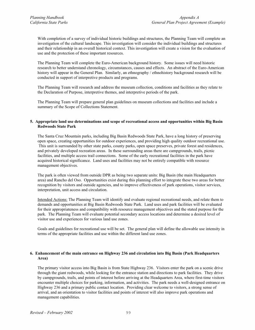
Planning Handbook Appendix ACalifornia State Parks General Plan Project Agreement (Example)
Revised – February 2002 99
With completion of a survey of individual historic buildings and structures, the Planning Team will complete aninvestigation of the cultural landscape. This investigation will consider the individual buildings and structuresand their relationship in an overall historical context. This investigation will create a vision for the evaluation ofuse and the protection of these important resources.
The Planning Team will complete the Euro-American background history. Some issues will need historicresearch to better understand chronology, circumstances, causes and effects. An abstract of the Euro-Americanhistory will appear in the General Plan. Similarly, an ethnography / ethnohistory background research will beconducted in support of interpretive products and programs.
The Planning Team will research and address the museum collection, conditions and facilities as they relate tothe Declaration of Purpose, interpretive themes, and interpretive periods of the park.
The Planning Team will prepare general plan guidelines on museum collections and facilities and include asummary of the Scope of Collections Statement.
5. Appropriate land use determinations and scope of recreational access and opportunities within Big BasinRedwoods State Park
The Santa Cruz Mountain parks, including Big Basin Redwoods State Park, have a long history of preservingopen space, creating opportunities for outdoor experiences, and providing high quality outdoor recreational use. This unit is surrounded by other state parks, county parks, open space preserves, private forest and residences,and privately developed recreation areas. In these surrounding areas there are campgrounds, trails, picnicfacilities, and multiple access trail connections. Some of the early recreational facilities in the park haveacquired historical significance. Land uses and facilities may not be entirely compatible with resourcemanagement objectives.
The park is often viewed from outside DPR as being two separate units: Big Basin (the main Headquartersarea) and Rancho del Oso. Opportunities exist during this planning effort to integrate these two areas for betterrecognition by visitors and outside agencies, and to improve effectiveness of park operations, visitor services,interpretation, unit access and circulation.
Intended Actions: The Planning Team will identify and evaluate regional recreational needs, and relate them todemands and opportunities at Big Basin Redwoods State Park. Land uses and park facilities will be evaluatedfor their appropriateness and compatibility with resource management objectives and the stated purpose for thepark. The Planning Team will evaluate potential secondary access locations and determine a desired level ofvisitor use and experiences for various land use zones.
Goals and guidelines for recreational use will be set. The general plan will define the allowable use intensity interms of the appropriate facilities and use within the different land use zones.
6. Enhancement of the main entrance on Highway 236 and circulation into Big Basin (Park HeadquartersArea)
The primary visitor access into Big Basin is from State Highway 236. Visitors enter the park on a scenic drivethrough the giant redwoods, while looking for the entrance station and directions to park facilities. They driveby campgrounds, trails, and points of interest before arriving at the Headquarters Area, where first-time visitorsencounter multiple choices for parking, information, and activities. The park needs a well-designed entrance onHighway 236 and a primary public contact location. Providing clear welcome to visitors, a strong sense ofarrival, and an orientation to visitor facilities and points of interest will also improve park operations andmanagement capabilities.

Planning Handbook Appendix ACalifornia State Parks General Plan Project Agreement (Example)
Revised – February 2002 100
Intended Actions: The Planning Team will evaluate existing conditions, determine visitor and operationalneeds, and establish goals and guidelines for enhancement of the main park entrance. Circulation on StateHighway 236 through the park and interrelationship with other land use guidelines will also be addressed. ThePlanning Team will also evaluate the concept of managing vehicle access as it relates to potential changes inland use and visitor use patterns.
7. Enhancement of the Highway 1 entrance to Rancho del Oso and the Nature and History Center
Limited access into Big Basin is also provided through the Rancho del Oso (RDO) area from State Highway 1at the mouth of Waddell Creek, which serves as a trailhead for hiking, horseback riding, mountain biking,windsurfing, tidepooling, and birdwatching. A separate access is provided to the Nature and History Center. Amix of recreational, interpretive, and administrative land uses and facilities occur in this overall area, andlimited access and parking facilities are provided. This area is located within the Coastal Zone and decisionsmay be influenced by the approved Local Coastal Plan.
Intended Actions: The Planning Team will study Waddell Beach, the Nature and History Center, and theRancho del Oso area generally to establish a primary purpose and vision for this area. This planning approachwill evaluate the potential long-term uses, identify impacts on resources, and develop guidelines to enhancevisitor experiences and integrate multiple land uses. Options to enhance this entrance will be studied to providebetter visitor orientation, interpretation and resource protection. Goals and guidelines for public access andappropriate visitor facilities and use will be developed.
8. Connectivity and compatibility of state park lands with surrounding land uses.
The California State Park and Recreation Commission, in July 1969, approved the proposed boundary lines ofBig Basin Redwoods State Park as described on the Land and Boundary Plan Map No. 11397, dated July 10,1969, signed by William Penn Mott, Jr., Director. This map, showing the Ultimate Park Boundary, has guidedthe Department and the Sempervirens Fund during the acquisition of lands for inclusion into the park. Thereare park properties outside this ultimate boundary that have been acquired or gifted to the Department for parkpurposes.
Intended Actions: The Planning Team will evaluate state park lands outside the 1969 boundary for potentiallinkages with surrounding state and county parks. These lands will be evaluated for their potential value asbiodiversity corridors, for park land connectivity and management, and for public land use. The general planwill provide goals and guidelines for management and/or future land additions. The team will also investigatepotential natural, cultural, interpretive and recreational values on state park lands outside the Ultimate ParkBoundary, and define how they contribute to the park as a whole.
9. Interpretation
Current and future interpretation for Big Basin Redwoods State Park should be evaluated to guide thedevelopment of an overall and integrated interpretive plan for the unit. The major spheres of consideration arethe Coast Redwood Forest and its ecosystem, the historic headquarters area, Rancho del Oso area, interpretivetrails, a possible State Park Museum, environmental and historic interpretive programs. Such interpretiveissues are important as they interact with most other aspects of the plan.
Intended Actions: The Planning Team will research and address interpretive issues, facilities, themes, periodsand topics for the unit. An Interpretive Prospectus may be prepared for this unit following the completion ofthe general plan.

Planning Handbook Appendix ACalifornia State Parks General Plan Project Agreement (Example)
Revised – February 2002 101
Compliance with the California Environmental Quality Act (CEQA)
A "tiered" approach will be used to meet the requirements of CEQA. A first tier EIR will be prepared for thegeneral plan. Subsequent management plans, area development plans, and specific project plans, implementing thegeneral plan may be subject to additional environmental review (second and third tiers, etc.). The degree ofspecificity will reflect the level of detail in the general plan and subsequent plans.
Potential adverse impacts in the first tier include:
• soil erosion and geological impacts• vegetation/habitat changes or loss• wildlife disturbance or loss• traffic generation and reduction in level of service• land use changes• loss or destruction of historical and archaeological resources• loss of recreational opportunities• non-conformance with local planning

Planning Handbook Appendix ACalifornia State Parks General Plan Project Agreement (Example)
Revised – February 2002 102
STAFFING & FUNDING PLAN FOR FUTURE GENERAL PLAN WORK
RESOURCE INVENTORY GENERAL PLANPERSON DAYS
STAFFING00/01 001/02 00/01 001/02 002/03 TOTALS
SENIORLANDSCAPEARCHITECT
(49.20)
5$1,968
5$1,968
5$1,968
10$3,936
10$3,936
35$13,776
ASSOCIATELANDSCAPEARCHITECT(PM) (44.80)
20$7,168
15$5,376
5$1,792
70$25,088
30$10,752
140$50,176
ASSOCIATELANDSCAPEARCHITECT
(3) (44.80)
35$12,544
30$10,752
00
120$43,008
80$28,672
265$94,976
HISTORIANIII
(44.50)
00
2$712
00
8$2,848
10$3,560
20$7,120
HISTORIANII
(38.00)
40$12,160
10$3,040
00
80$24,320
40$12,160
170$51,680
SENIORRESOURCEECOLOGIST
(42.30)
2$676
00
00
5$1,692
5$1,692
12$4,060
SENIORRESOURCE
ECOLOGIST II(37.70)
90$27,144
20$6,032
00
120$36,192
80$24,128
310$93,496
ASSOCIATEARCHAEOLOGIST
I (37.70)
190$57,304
12$3,619
00
90$27,144
60$18,096
352$106,163
INTERPRETER II(38.00)
30$9,120
10$3,040
00
30$9,120
15$4,560
85$25,840
ASSOCIATEPARK &
RECREATIONSPECIALIST (41.60)
10$3,328
15$4,992
00
34$11,315
26$8,653
85$28,288
TOTALPERSONAL
DAYS
232$131,412
119$39,531
10$3,760
567$184,663
356$116,209
$475,575
Total $170,943 $304,632
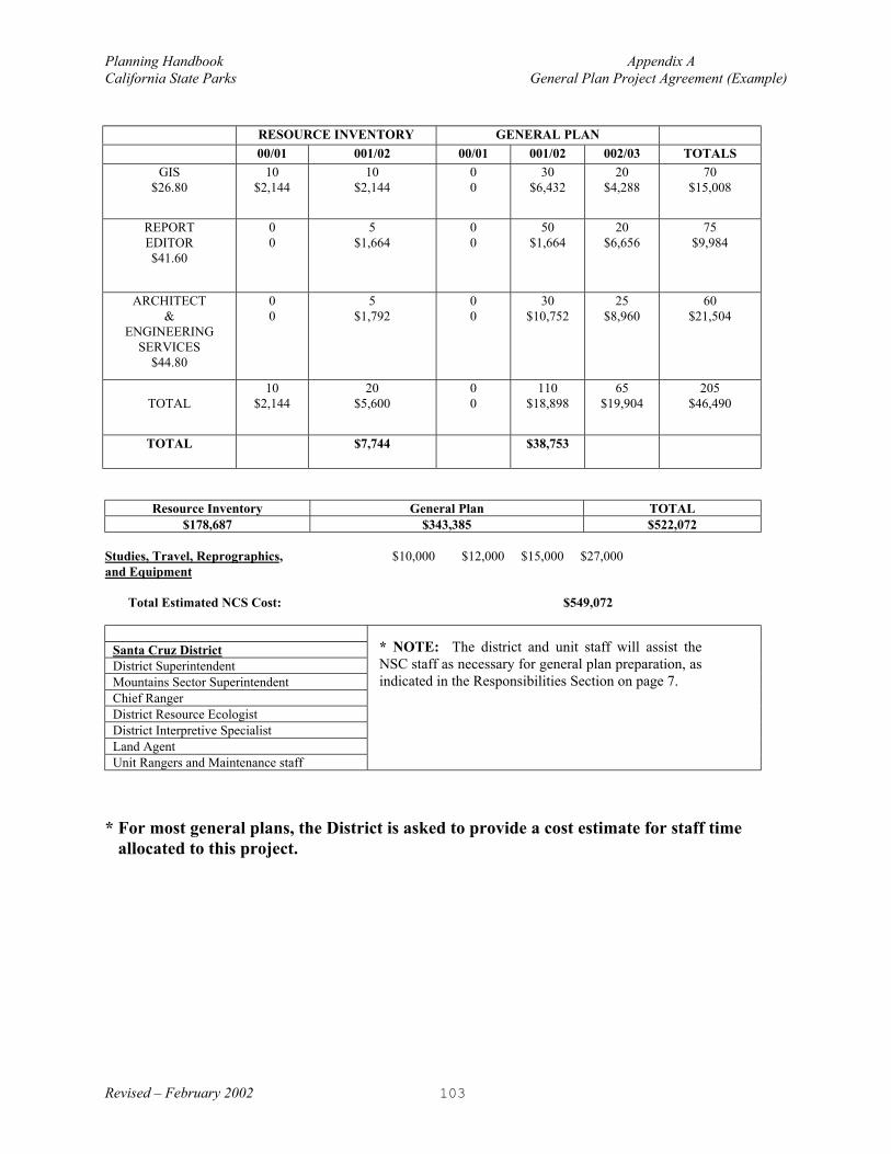
Planning Handbook Appendix ACalifornia State Parks General Plan Project Agreement (Example)
Revised – February 2002 103
RESOURCE INVENTORY GENERAL PLAN00/01 001/02 00/01 001/02 002/03 TOTALS
GIS$26.80
10$2,144
10$2,144
00
30$6,432
20$4,288
70$15,008
REPORTEDITOR$41.60
00
5$1,664
00
50$1,664
20$6,656
75$9,984
ARCHITECT&
ENGINEERINGSERVICES
$44.80
00
5$1,792
00
30$10,752
25$8,960
60$21,504
TOTAL10
$2,14420
$5,60000
110$18,898
65$19,904
205$46,490
TOTAL $7,744 $38,753
Resource Inventory General Plan TOTAL$178,687 $343,385 $522,072
Studies, Travel, Reprographics, $10,000 $12,000 $15,000 $27,000and Equipment
Total Estimated NCS Cost: $549,072
Santa Cruz DistrictDistrict SuperintendentMountains Sector Superintendent Chief RangerDistrict Resource EcologistDistrict Interpretive SpecialistLand AgentUnit Rangers and Maintenance staff
* For most general plans, the District is asked to provide a cost estimate for staff timeallocated to this project.
* NOTE: The district and unit staff will assist theNSC staff as necessary for general plan preparation, asindicated in the Responsibilities Section on page 7.

Planning Handbook Appendix ACalifornia State Parks General Plan Project Agreement (Example)
Revised – February 2002 104
SCHEDULE
General Planning Work Schedule
AnticipatedScope of Work
AnticipatedCompletion Date
Prepare New Project Agreement April 2001
Public Meeting (Issues & Concerns) #1Information gathering to assess existing conditions
June 2001
Analysis of issues, focused study and gathering of additionalinformation
August 2001
Preparation of Alternatives November 2001
Public meeting/planning workshop #2 Present & discuss Alternatives
November 2001
Preparation of Single Plan March 2002
Public Meeting (Present Single Plan) #3Public review and comments
April 2002
Produce Draft General Plan Document July 2002
DPR Review of Draft GP & Revisions August 2002
Prepare Preliminary GP for CEQA review August 2002
CEQA Review and Response to Comments October 2002
Director’s Briefing October 2002
Parks and Recreation Commission Hearing October 2002
Final General Plan & EIR December 2002

Planning Handbook Appendix ACalifornia State Parks General Plan Project Agreement (Example)
Revised – February 2002 105
SIGNATURES
California Department of Parks and RecreationPlanning, Policy and Programming Committee (PPPC)
Keith Demetrak, Committee ChairmanChief, Planning Division
Date:
California Department of Parks and RecreationSanta Cruz District
Dave Vincent, District Superintendent
Date:
California Department of Parks and RecreationNorthern Service Center
Kathy Amann, Manager
Date:
California Department of Parks and RecreationBig Basin Redwoods SP General Planning Team
Dave Keck, Supervisor, General PlanningNorthern Service Center
Date:

Planning Handbook Appendix BCalifornia State Parks Unit Data File (UDF) Matrix (Example)
Revised – February 2002 106
APPENDIX B
UNIT DATA FILE (UDF) MATRIX(Example)
The following matrix provides staff with the opportunity to score the importance of the resourceinformation and its availability. This scoring guide indicates what inventory work is neededprior to proceeding with the request for a general plan.
An assessment team, established by the District Superintendent or regional Service Center, usesthis UDF matrix to determine if sufficient information is available to schedule a general plan.This form is also used as a tool by the general plan team to identify gaps in the data prior to theactual beginning the general plan process.

Planning Handbook Appendix BCalifornia State Parks Unit Data File (UDF) Matrix (Example)
Revised – February 2002 107


Planning Handbook Appendix BCalifornia State Parks Unit Data File (UDF) Matrix (Example)
Revised – February 2002 109
UDF MATRIX (Example)
Unit Data File - (Index/Evaluation) Scoring Guide*D1, D2, C1: Inventory work is needed prior to proceeding with request for generalplan.
Park Unit Name Palomar Mountain SP All Others: No inventory work is needed prior to proceeding with request for generalplan.
Park Unit Number 812Importance of Information
Availability of Information
A B C D 1 2 3File Name Sub File Name Not needed Low Medium High None Some Comprehensive Score*Plant Life Mapped x x D3
Communities x x D2Terrestrial Vegetation x x D2Rare andEndangered
x x D3
Special Interest Flora x x D2Exotic Flora x x B1Marine Flora x x B2Monitoring data x x C1
Animal Life MappedTerrestrial Animal LifeThreat. &EndangeredAquatic/MarineFauna
Importance of Information
Availability of Information

Planning Handbook Appendix BCalifornia State Parks Unit Data File (UDF) Matrix (Example)
Revised – February 2002 110
A B C D 1 2 3File Name Sub File Name Not needed Low Medium High None Some Comprehensive Score*
Special InterestFaunaMonitoring data
Geology/Soils MappedGeologic HistoryUnique FeaturesVolcanic HazardSeismicityErosionMineral ResourcesSoil MapsGeomorphology
Hydrology MappedWatershedsWater QualityWater QuantityWater RightsData and reportsWatershed FeaturesFlooding
Importance of Information
Availability of Information
A B C D 1 2 3

Planning Handbook Appendix BCalifornia State Parks Unit Data File (UDF) Matrix (Example)
Revised – February 2002 111
File Name Sub File Name Not needed Low Medium High None Some Comprehensive Score*
Meteorology Climatic RecordsIsohaietal maps
Cultural Resources MappedArchaeological sitesHist. Sites &StructuresEuroamerican HistorySensitivity zones
Esthetic Resources MappedCongruent featuresIncongruent features
RecreationResources
Mapped
Recreation FacilitiesUser SurveysAttendance Data
Importance of Information
Availability of Information
A B C D 1 2 3

Planning Handbook Appendix BCalifornia State Parks Unit Data File (UDF) Matrix (Example)
Revised – February 2002 112
File Name Sub File Name Not needed Low Medium High None Some Comprehensive Score*
Public Use Facilities MappedWaterSewerTelephoneElectrical
Land Use MappedLand Rec. AreasWater Rec. AreasEntrance AreasAdministrative AreasWilderness AreasPreserve/Reserve
Interpretive MappedInterpretive PeriodUnit HistoryOral HistoriesNatural History Info.Statistics
Scope of Collections Museum CollectionsArcheologicalArchives
Importance of Information
Availability of Information
A B C D 1 2 3

Planning Handbook Appendix BCalifornia State Parks Unit Data File (UDF) Matrix (Example)
Revised – February 2002 113
File Name Sub File Name Not needed Low Medium High None Some Comprehensive Score*
Mapping/photos Aerial PhotosGISUnit Base MapsVideo/photo recordsAPN Data base
Acquisition History ClassifiedParcel mapsDedicationinformationBoundary Survey
Visitor Use Info MappedAttendancePoint of originsTrends identified
Regional Planning Coastal Plan areaSpecial Planning areaAdjacent planningZoning mapsTrail planningTraffic analysis
Importance of Information
Availability of Information
A B C D 1 2 3

Planning Handbook Appendix BCalifornia State Parks Unit Data File (UDF) Matrix (Example)
Revised – February 2002 114
File Name Sub File Name Not needed Low Medium High None Some Comprehensive Score*
Constraints Existing MOU'sConcessionsBinding agreements
Park Management Fire Mgmt. PlansCEQA FilesTree HazardsDischarge PermitsPest Management Agency PermitsIssues ResolutionMgmt. Actions

Planning Handbook Appendix CCalifornia State Parks Meta Data (Example)
Revised – February 2002 115
APPENDIX C
META DATA(Example)
The following example was taken from the Department’s website at the following address:http://intranet.inside.parks.ca.gov/offices/general_plans/about/about06.htm
Central Division - Bay AreaCandlestick Point State Recreation Area
Identifier General Plan Document Citation Information
Title Candlestick Point State Recreation AreaResource Management Plan, General Development Plan, andEnvironmental Impact Report
Originator California State Park System
Edition General Development Plan 1978 - 120-pages 10,757kbGeneral Plan Amendment 1987 - 103-pages 6,385kb
PublicationDate
Approved 1978, Final Printed June 1979This GDP was made functionally obsolete when the PRC approved a"General Plan Amendment" in May 1987.The Final Amendment report, printed in March 1988, revised or reprintedthe entire original RMP - GDP -EIR.
InformationResource
Type Format: Hardcopy, Adobe Portable Document Format (PDF)Content: Documents; Maps; Reports
Other CitationDetails State Park and Recreation Commission Resolution 64-78
Identification Information
Abstract Provides resource management policies and development proposals forCandlestick Point SRA, the State Park System's first urban development.
Purpose
Provides general guidelines for all area development and management. Candlestick Point SRA, with its bay shoreline, is less than one hour awayfrom millions of urban dwellers; with statewide significance of an acreageand shoreline on the biggest and most significant estuarine system inCalifornia.The SRA enables the State Park System to extend recreational and culturalfacilities to urban areas, where opportunities for access to the system havetraditionally been limited.
Time Period 1970's - 1980's Currentness As of Publication Date

Planning Handbook Appendix CCalifornia State Parks Meta Data (Example)
Revised – February 2002 116
Progress Complete Update
Frequency None
Place
California170 acres, and about 3 1/2 miles of San Francisco Bay shoreline; Projectboundary abuts the US Naval Shipyard at the furthest northern border andthe San Mateo County line to the South. Project is directly across the streetfrom the San Francisco Executive Park, Candlestick Stadium, and the AliceGriffith Housing project.
GeographicRegion
Southeast part of San Francisco City and County.Northeast part of San Mateo County.Access is from Highway 101 (Bayshore Freeway) and city streets.
Themes Park Districts; Parks; State Recreation Area
UserKeywords California State Parks; Department of Parks and Recreation
AccessLimitations Public
UseLimitations
Free Use - except in cases of copyright publications. Note however that thesupplier is not responsible for inappropriate use of this dataset, nor is heresponsible for any erroneous conclusions as a result of use of this dataset.
Data Contact State of California, Park Services Division
Distribution Information Online
Linkage Departmental Intranet
DistributionFormat Adobe Acrobat Portable Document Format (PDF)
DistributionContact State of California, Central Records

Planning Handbook Appendix DCalifornia State Parks Management Zone Matrix (Example)
Revised – February 2002 117
APPENDIX D
MANAGEMENT ZONE MATRIX(Example)
The example on the following pages was taken from the Chino Hills State Park General Plan, datedFebruary 1999. This example describes four management zones, and for each zone addresses theprimary goal, resource management, carrying capacity, typical visitor activities, public access, andthe range of appropriate facilities. There is no set standard or single way to prepare a managementzone matrix. Other general plan examples can be found (Humboldt Redwoods SP, Castle Rock SP,and Mount San Jacinto SP), which should be reviewed for alternative methods in preparing a matrixfor discussion of management zone or land use areas.
Please refer to a previous section in this handbook titled: Guidelines to the Plan Section for a moredetailed discussion and guidelines on the preparation of Management Zones.

Planning Handbook Appendix DCalifornia State Parks Management Zone Matrix (Example)
Revised – February 2002 118
Core Habitat Zone Natural Open Space ZonePRIMARY GOAL The primary goal of the Core Habitat Zone
is to preserve and protect sensitive plantand animal species and their supportinghabitats, as well as to protect themovement of plants and animals within thepark and throughout the region. Resourceprotection will be the foremostconsideration for all land use andmanagement decisions.
The primary goal for the Natural Open SpaceZone is to preserve and protect the resourcesand at the same time to provide for qualityrecreational opportunities.
RESOURCEMANAGEMENT
Visitor and management activities withinthe zone will have no significant adverseimpact on resources. Patrol and utilitycompany vehicles and motorizedequipment use is permitted on designatedpark roads and trails.
Visitor use and management activities will nothave more than minimal impacts on resources. Patrol and utility company vehicles andmotorized equipment use is permitted ondesignated park roads and trails.
CARRYINGCAPACITY
Visitors will experience a sense ofremoteness and calm. The sights andsounds of nature will be more prevalentthan those of human use. The chance ofencountering other people will be low, andthere will be extensive opportunities toexperience natural quiet and solitude. Encounters with others should be less than2/hour during peak use periods. Humanuses will not disrupt or compromisesensitive resources.
The social environment will be leisurely anduncrowded with occasional sights and soundsof people. During some seasons, days, andtimes of day, there will be a good chance ofencountering other people or groups of people. Opportunities for natural quiet and solitude willbe variable depending upon the park locationand season, day, and time of day. Encounterswith others should be less than 6/hour duringpeak-use periods.
TYPICALVISITORACTIVITIES
Acceptable uses of the Core Habitat Zoneinclude approved scientific research thatincreases our knowledge of the resourcesand improves management strategies.Conducted and self-guided interpretiveprograms are acceptable in the CoreHabitat Zone. Visitor activities will beconfined to daylight hours only.
Conducted and self-guided interpretiveprograms are acceptable in the Natural OpenSpace Zone. Visitor activities will be confinedto daylight hours only.
PUBLIC ACCESS Public access through the zone includeshiking, biking, and horseback riding. Bikers and horseback riders are restrictedto designated trails only.
Public access through the zone includeshiking, biking, and horseback riding. Bikersand horseback riders are restricted todesignated trails only.
RANGE OFAPPROPRIATEFACILITIES
Multiple-use trails, trailhead features, andtrailside rest stops are appropriate.
Multiple-use trails, trailhead features, trailsiderest stops, and day-use parking alongboundary (see Park Access Points, Page 70)are appropriate.

Planning Handbook Appendix DCalifornia State Parks Management Zone Matrix (Example)
Revised – February 2002 119
Historic Zone Recreation and Operations ZonePRIMARY GOAL The primary goal of the Historic Zone is to
protect the cultural resources and at thesame time to provide for qualityrecreational and educational experiences.
The primary goal of the Recreation andOperations Zone is to provide for vehicleaccess, structured recreation, visitor service,and operational needs.
RESOURCEMANAGEMENT
Visitor use and management activities willnot have more than minimal impacts tonatural and aesthetic resources, and willinclude only those that does not detractfrom the historical setting and experiences. Vehicles and motorized equipment will beallowed on designated park roads andtrails and will be managed to minimizeimpacts. Protection of cultural sites willinclude preservation of the surroundingcultural and natural landscapes by theelimination and exclusion of modernintrusions that adversely affect the culturallandscapes.
Visitor use and management activities will bemitigated to reduce significant impacts toresources. Activities may include themovement of vehicles, and intense visitor use. Vehicles and motorized equipment will beallowed on designated park roads and trails.
CARRYINGCAPACITY
The social environment will be active andcommunal. At times, the sights andsounds of human use and activities will bemore prevalent than those of nature. There will be frequent encounters withvehicles, other people, and groups ofpeople. The chance of interacting withothers will be high.
The social environment is active andcommunal. At times, the sights and sounds ofhuman use and activities are more prevalentthan those of nature. There are frequentencounters with vehicles, other people, andgroups of people. The chance of interactingwith others will be high.
TYPICALVISITORACTIVITIES
Acceptable activities include interpretationand educational programs, exhibits, andhistoric structure museums. Opportunitiesfor other interpretive programs andappropriate visitor services also exist. Overnight use is limited to educational andenvironmental living programs.
Acceptable activities include vehiclecirculation, interpretation, camping, picnicking,and other forms of recreation suitable in thepark. Overnight uses will be permitted only inspecific areas designated for such use.
PUBLIC ACCESS Public access through the zone includeshiking, biking, horseback riding, and driving(highway legal vehicles). Bikers andhorseback riders are restricted to roadsand designated trails only.
Public access through the zone includeshiking, biking, and horseback riding ondesignated trails and driving (highway legalvehicles). Bikers and horseback riders arerestricted to roads and designated trails only.
RANGE OFAPPROPRIATEFACILITIES
Only those facilities that support thevisitor’s use, understanding, andappreciation of the historical landscapeand that are visually compatible with thehistorical scenery are appropriate.
Any visitor service and support facilities thatare consistent with Parkwide and Specific AreaGoals and Guidelines are appropriate. Thesecould include but are not limited to:- Overnight Accommodations (camping,lodging) - Concession Facilities - Restrooms- Park Operations Buildings - Roads andTrails