guidelines for the construction or modification of ... · pdf file3 guidelines for the...
TRANSCRIPT

Guidelines for the construction or modification of category 2 and 3 levees

This publication has been compiled by Water Policy, Department of Natural Resources and Mines.
© State of Queensland, 2014
The Queensland Government supports and encourages the dissemination and exchange of its information. The copyright in this publication is licensed under a Creative Commons Attribution 3.0 Australia (CC BY) licence.
Under this licence you are free, without having to seek our permission, to use this publication in accordance with the licence terms.
You must keep intact the copyright notice and attribute the State of Queensland as the source of the publication.
For more information on this licence, visit http://creativecommons.org/licenses/by/3.0/au/deed.en
The information contained herein is subject to change without notice. The Queensland Government shall not be liable for technical or other errors or omissions contained herein. The reader/user accepts all risks and responsibility for losses, damages, costs and other consequences resulting directly or indirectly from using this information. To be read in conjunction with the IDAS code for development applications for construction or modification of particular levees.
2 Guidelines for the construction or modification of category 2 and 3 levees
Table of contents 1. Purpose ........................................................................................................................................... 5
2. Definition of a levee ........................................................................................................................ 7
2.1 Inclusions .................................................................................................................................................. 7
2.2 Exclusions .................................................................................................................................................. 7
3. Construction or modification of levees ........................................................................................... 8
4. Levee category ................................................................................................................................ 9
4.1. Calculating off-property impacts .............................................................................................................. 9
4.2. Calculating the number of impacted people............................................................................................. 9
4.2 Engagement of a suitably qualified person ............................................................................................ 10
5. Roles and responsibilities .............................................................................................................. 10
6. Assessing Category 2 and 3 levees ................................................................................................ 13
6.1 Difference between category 2 and 3 levee application and assessment requirements ........................ 14
6.2 Step 1. Determine whether the levee is a suitable option for flood mitigation ...................................... 14
6.2.1 Understanding the catchment ..................................................................................................................... 15
6.2.2 Levees as a flood mitigation option ............................................................................................................. 16
6.2.3 Suggested outcomes for category 2 and 3 levees ........................................................................................ 17
6.2.4 Further information ..................................................................................................................................... 18
6.3 Step 2. Conceptual design of the levee ................................................................................................... 18
6.3.1 Considerations when setting the levee location and alignment .................................................................. 19
6.3.2 Considerations when setting the levee height ............................................................................................ 20
6.3.3 Preliminary risk assessment ......................................................................................................................... 21
6.3.4 Outputs of the conceptual design phase ..................................................................................................... 21
6.4 Step 3. Consultation ................................................................................................................................ 21
6.4.1 Pre-lodgement meeting with the assessment manager .............................................................................. 22
6.5 Step 4. Detailed design phase: hydrological/hydraulic assessment ....................................................... 23
6.5.1 Contents of a hydrological/hydraulic assessment ....................................................................................... 23
6.5.2 Modelling ..................................................................................................................................................... 24
6.5.3 Hydraulic assessment process ..................................................................................................................... 25
6.5.4 Linking with existing models and studies ..................................................................................................... 25
6.6 Step 5. Detailed design phase—levee categorisation and impact acceptability .................................... 26
6.6.1 Calculating the affected population............................................................................................................. 26
6.6.1 PO1 Any off-property impacts from the levee are minimised and acceptable ............................................ 27
6.7 Step 6a. Detailed design phase—design specification and operations and maintenance ..................... 29
6.7.1 Design specification and standards ............................................................................................................. 29
6.7.1 Operations and maintenance ...................................................................................................................... 31
6.8 Step 6b. Community resilience ................................................................................................................ 33
3 Guidelines for the construction or modification of category 2 and 3 levees

6.9 Step 7. Emergency management ............................................................................................................ 35
Appendix A: Glossary ............................................................................................................................ 37
Appendix B: References ........................................................................................................................ 40
Appendix C: Activities excluded from the definition of levees ............................................................. 42
Appendix D: Levee Failure mechanisms and deterioration modes (see section 6.7.1) ........................ 47
Appendix E: Default populations for occupied buildings ...................................................................... 57
4 Guidelines for the construction or modification of category 2 and 3 levees
1. Purpose This document provides information to help proponents meet the requirements under the Sustainable Planning Regulation 2009 (the regulation) for the construction of new levees and modification of existing levees.
The guidelines provide information relating to the following codes:
• IDAS Code for development applications for construction or modification of particular levees (Schedule 15B of the Water Regulation 2002 at www.legislation.qld.gov.au).
• Construction or modification of levees state code as part of the State Development Assessment Provisions (www.dsdip.qld.gov.au/development-applications).
Guidelines in relation to the Self-assessable code for the construction of new levees or the modification of existing levees are provided in Guidelines for the construction or modification of category 1 levees (www.dnrm.qld.gov.au).
The regulation will not apply to levees that are under construction at the commencement date of the regulation. Physical construction on building or modifying the levee bank must have started for a levee bank to be considered 'under construction'. A levee bank is not considered to be under construction unless all applicable permissions have been received, land acquisitions completed and work begun.
These guidelines are designed to be used by:
• landholders interested in constructing a new levee or modifying an existing levee • suitably qualified persons engaged by proponents to design and construct a levee • assessment managers from the local government authorities • consultants engaged by either proponents or local government authorities.
Note: These guidelines do not provide technical standards or detailed methodologies for the design, construction, modification or maintenance of levees. The detailed design and construction or modification of levees is recommended to be undertaken by suitably qualified person with relevant professional experience and knowledge.
These guidelines will be reviewed and updated periodically by the Queensland Government. They may be changed over time and are not designed to apply to every type of proposal.
Use of the guidelines
It is important to note that these are guidelines only and therefore have no statutory authority. They are designed to assist in the interpretation of the relevant codes.
Any application to construct or modify a levee is required to comply with the codes listed above which override any information that is contained in these guidelines.
The following appendixes are provided in these guidelines:
• Appendix A contains a glossary of terms used in the guidelines. • Appendix B provides a list of references for further information that may be of use to
the proponent, levee designer or the assessment manager.
5 Guidelines for the construction or modification of category 2 and 3 levees

• Appendix C details the activities excluded from the definition of levees and how those activities are currently managed.
• Appendix D contains additional information on levee failure mechanisms and deterioration modes.
• Appendix E details the default populations for occupied buildings which are used to determine the population impacted by a levee.
6 Guidelines for the construction or modification of category 2 and 3 levees

2. Definition of a levee
2.1 Inclusions
The Water Act 2000 defines a levee as:
A levee is an artificial embankment or structure which prevents or reduces the flow of overland flow water onto or from land.
A levee includes levee-related infrastructure, which is defined as infrastructure that is:
a. connected with the construction or modification of the levee or
b. used in the operation of the levee to prevent or reduce the flow of overland flow water onto or from land.
Levees can be constructed in a number of ways, for example earthen embankments, crib walls or concrete walls. Earthen or earthfill levees are the most commonly constructed. They are constructed only of soil material, which can include clay, silt, gravel, sand and rocks. Earthen levees can include fill material that is pushed up or deposited for the purposes of diverting overland flow water. Other types of levees, such as crib walls or concrete retaining walls, are often used in more restrictive or difficult sites.
2.2 Exclusions
The Water Act 2000 also includes a number of activities that are excluded from the definition of a levee, as follows:
a. prescribed farming activities
b. fill that is—
i. deposited at a place for gardens or landscaping, including, for example, landscaping for the purposes of visual amenity or acoustic screening and
ii. less than the volume of material prescribed under a regulation (prescribed as 50m3 in Section 62B of the Water Regulation 2002)
c. infrastructure used to safeguard life and property from the threat of coastal hazards
d. a structure regulated under another Act including, for example, the following—
i. a levee constructed as emergency work under the Planning Act, section 584 or 585
ii. a structure constructed under an approved plan under the Soil Conservation Act 1986
iii. a structure whose design takes into account the impacts of flooding or flood mitigation but which is not primarily designed for flood mitigation Example - a public road within the meaning of the Transport Infrastructure Act 1994
iv. a structure constructed within the bed, or across a bank, of a watercourse, including, for example, a weir or barrage, the construction of which was carried out under this Act and for which a development permit under the Planning Act was given
v. an embankment or other structure constructed for long-term storage of water under the Water Supply Act
7 Guidelines for the construction or modification of category 2 and 3 levees
Examples - a ring tank or dam
e. irrigation infrastructure that is not levee-related infrastructure.
irrigation infrastructure means water infrastructure or other infrastructure constructed, erected or installed for the supply of water or the storage and distribution of water for the irrigation of crops or pastures.
Examples of irrigation infrastructure - a supply channel, head ditch or tailwater drain
levee-related infrastructure means infrastructure, including irrigation infrastructure, that is—
a. connected with the construction or modification of the levee or
b. used in the operation of the levee to prevent or reduce the flow of overland water onto or from land.
Examples of infrastructure for paragraph (b) - a channel, drain, outfall or pipe
prescribed farming activities means—
a. cultivating soil Examples - clearing, replanting and broadacre ploughing
b. disturbing soil to establish non-indigenous grasses, legumes or forage cultivars
c. using land for horticulture or viticulture or
d. laser levelling or contouring soil.
Appendix C provides more information on the activities that are excluded from the definition of levees and where these activities may be captured by other legislation or regulations. Where there is uncertainty around whether an activity or structure is defined as a levee, the proponent should contact the assessment manager.
3. Construction or modification of levees These steps apply to the construction of new levees or the modification of existing levees. A new levee is a structure that is built where no pre-existing levees are in place for flood mitigation or other purposes.
An existing levee means a levee:
a) that
• was under construction when section 967 of the Water Act 2000 commenced and • has not been modified since the construction of the levee was completed or
otherwise came to an end or
b) that was existing on the commencement and has not been modified since.
Modify, for an existing levee, means any or all of the following:
• to raise or lower the height of the levee • to extend or reduce the length of the levee • to make another change to the levee that affects the flow of water.
8 Guidelines for the construction or modification of category 2 and 3 levees

4. Levee category For the purposes of regulation, levees in Queensland are classified into three categories based on their potential level of impact. The categorisation ensures that the level of assessment that a levee application will need to go through is proportionate to the level of risk that the levee poses to people, property and the catchment.
The three categories and their respective assessment level are as follows:
Category Definition Level of assessment Assessor
Category 1 A levee that has no off-property impact
Self-assessment Applicant
Category 2 A levee that has an off-property impact and for which the affected population is less than 3
Code assessment Local government
Category 3 A levee that has an off-property impact and for which the affected population is at least 3
Impact assessment Local government with Queensland Government as referral agency
4.1. Calculating off-property impacts
Off-property impacts determine whether a proposed levee is subject to self-assessment or code/impact assessment. Self-assessment only applies to levees that have no off-property impacts. If a levee does not meet this requirement of no off-property impacts, it is subject to code and impact assessment (category 2 and 3 levees)
Self-assessable levees will typically be structures built or modified on a large rural property far enough from other properties to cause no impact. The smaller property size in other zones, such as urban zones, means that any sized levee in these zones will almost certainly result in some type of impact beyond the property boundary.
An off-property impact means an impact the levee has on people, property or the environment outside the levee property. Off-property impacts are measured in terms of the hydraulic effects of the levee. If the construction or modification of a levee results in no changes to the flow path, flow velocity, flooded area or flood height of floodwaters or overland flow waters beyond the boundary of the property on which it is located, this levee is considered to have no off-property impacts and is subject to self-assessment.
Refer to Guidelines for the construction or modification of category 1 levees for more information on how to calculate off-property impacts.
4.2. Calculating the number of impacted people
For levees that have off-property impacts, a risk assessment is required to determine the impacts of the proposed levee on people, property and the environment. As part of this risk assessment, the affected population will need to be calculated in order to classify the levee
9 Guidelines for the construction or modification of category 2 and 3 levees
as category 2 or 3. Affected population, for a levee, means the total number of persons occupying the building or buildings on which the levee has a significant impact.
A significant impact for a levee on a building means each of the following:
• an increase, caused by the levee, of more than 5cm in the flow height of water over the floorboards of the building
• an increase, caused by the levee, of more than 0.2m/s in the flow velocity of water over the height of the floorboards of the building.
An occupied building is a building with an allocated default population in line with Appendix E.
Refer to section 6.6 of these guidelines for more information on calculating the number of impacted people.
4.2 Engagement of a suitably qualified person
It is recommended that for all levees the levee proponent engage a suitably qualified person to assist in meeting the requirements of the codes. This person should be engaged as early as possible in the process.
A suitably qualified person is defined as a person with the necessary qualifications and experience to undertake risk assessments, hydraulic studies or the design and construction of a levee.
An example is a Registered Professional Engineer of Queensland (RPEQ) under the provisions of the Professional Engineers Act 2002, such as a civil engineer who has demonstrated competency and relevant experience in the design and construction of levee banks or other flood infrastructure.
A suitably qualified person engaged in the design and construction of the levee will have access to relevant Australian and international standards and expertise necessary to meet the IDAS code requirements.
5. Roles and responsibilities There are typically many participants (individuals and organisations) involved in flood risk and levee management who need to interact together and communicate information in order to perform their relevant roles and responsibilities efficiently and effectively.
These roles may be filled by the same person (in the case of simple levees where the levee proponent, designer and constructor may be the same person) or in the case or larger, more complex levees, many different people or companies.
In this section, the focus is on roles and responsibilities rather than organisations because many variants are possible within individual organisations. For example:
• the organisation which owns the levee may also employ the designers and project managers
• the construction company may take responsibility for the design and the project management as well as for the construction itself.
10 Guidelines for the construction or modification of category 2 and 3 levees
Clearly defined roles and responsibilities are fundamental for efficient delivery of levee design and construction. The levee proponent or project manager should evaluate project needs, clarify roles and responsibilities and establish effective lines of communication.
It is recognised that these roles and responsibilities will not be applicable to assessments and applications for all levee categories.
The following roles have been defined:
Levee proponent
The levee proponent, landholder or levee owner has the responsibility of funding the design, construction and operation and maintenance of the levee up to the design life. Should the levee asset be required to be maintained beyond the design life, then it is the responsibility of the levee proponent to repeat the cycle of design and construction of the levee in perpetuity. Adequate records of design, construction and maintenance records should form part of any levee asset management plan, and these records should be handed over when there is a change of ownership.
Applicant
For the purposes of these guidelines, it is assumed that the applicant is the levee proponent, landholder or levee owner. In some cases the applicant can be both the levee proponent and the designer. Also, the levee owner can delegate the application role to another party, but the responsibility of the application rests with the levee proponent.
Designer
A suitably qualified person may be needed to certify the levee design if it is a category 2 or 3 levee. Under Queensland law, penalties apply if a professional engineer certifies a design or flood impact assessment that contains information that the engineers knows is false or misleading and does not disclose this (refer to the Professional Engineers Act 2002).
The designer will be responsible for the technical elements of the project, and will work closely with the levee proponent to ensure the relevant code requirements are properly addressed. The designer may also have responsibilities for checking that the constructor is complying with the contractual requirements including adherence to the design drawings and the specifications.
Project manager
The project manager must have sufficient knowledge and experience to manage a wide variety of disciplines. Good overall project management is crucial to the timely delivery of projects, but all team members must understand their roles and contribute accordingly to achieve success. Project managers should have an understanding of levee construction, risk identification, analysis and management and may have to manage conflicting requirements.
Constructor
The constructor is responsible for adhering to the design and specifications provided by the project team. The constructor must provide sufficient quality assurance documentation to the levee proponent to satisfy the levee proponent and the assessment manager that the levee has been constructed to the technical requirements of the design and specifications.
11 Guidelines for the construction or modification of category 2 and 3 levees

Employment of the levee designer or an independent certifying authority is often a means of achieving construction certification to ensure that the design intent is expressed in the construction methodology, and that the construction complies with the certified design.
Assessment manager
The assessment manager is the local government who is responsible for assessing the levee application against the IDAS code and then making a decision on whether to approve, approve with conditions or reject a proposal. In some cases, the local government may choose to employ an independent expert to assist in the assessment of levee applications. The assessment manager has the responsibility of reviewing the flood impact assessment and levee design, and has the power to accept, reject or require further review of design information. The assessment manager may require the levee proponent to provide additional information to assist in the decision to accept a levee design. If the assessment manager requires a review of the design, the levee proponent may need to review, correct or complete the design, have it re-certified by a suitably qualified person and re-submit the design to the assessment manager for approval.
If the levee design is accepted and the levee is category 2 or 3, then the assessment manager may impose conditions of approval to ensure that any ongoing safety concerns are addressed. This may take the form of regular inspections, operation and maintenance requirements or emergency management plans.
Referral agency
Category 3 levees are referred to the Queensland Government for assessment against the state code contained in Module 7 of the State Development Assessment Provisions (SDAP). It is the responsibility of the levee proponent to forward a copy of the category 3 application to the Queensland Government for assessment. The Queensland Government will assess the levee application and can approve, approve with conditions or reject a proposal.
12 Guidelines for the construction or modification of category 2 and 3 levees
6. Assessing Category 2 and 3 levees If, following an initial assessment of the possible impacts of the construction or modification of a levee it has been concluded that it will have off-property impacts, then this section will give additional guidance on how to address the performance outcomes in the IDAS Code for development applications for construction or modification of levees and the information the proponent will need to provide to the assessment manager and the concurrence agency (Department of State Development, Infrastructure and Planning).
If as a consequence of this further assessment you determine that the levee will have no off-property impacts you are referred to the Self-assessable code for the construction or modification of levees which can be found on the Department of Natural Resources and Mines website.)
It should be noted that the steps below should be considered as part of an iterative process involving design elements, risk identification, consultation and mitigation measures, rather than a sequential series of steps. For example, as more information and data is gathered in the detailed design phase, this might necessitate a review and adjustment of the hydraulic assessment or levee options.
The code comprises a set of requirements, including performance outcomes and acceptable outcomes). Acceptable outcomes represent ways in which the relevant performance outcomes can be met. An application that complies with the applicable acceptable outcomes will satisfy the relevant performance outcome.
If an application does not comply with all acceptable outcomes or no acceptable outcome has been provided, the proposed development must comply with the relevant performance outcome in order to comply with the purpose of the code.
The steps involved in the application process for category 2 and 3 levees are listed below and Figure 6.1 provides an overview. The performance outcomes in the IDAS code and state code are noted beside the relevant step:
• Determine whether the levee is a suitable option for flood mitigation • Conceptual design phase • Consultation • Detailed design phase—hydrological/hydraulic assessment • Detailed design phase—levee categorisation and impact acceptability (PO1) • Detailed design phase—design specification and operations and maintenance (PO2) • Community resilience (PO1 in Construction or modification of levees state code) • Emergency management (PO3)
13 Guidelines for the construction or modification of category 2 and 3 levees
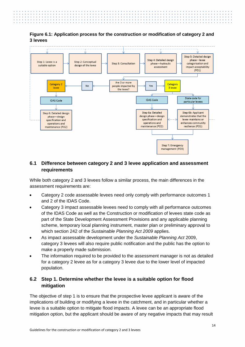
Figure 6.1: Application process for the construction or modification of category 2 and 3 levees
6.1 Difference between category 2 and 3 levee application and assessment requirements
While both category 2 and 3 levees follow a similar process, the main differences in the assessment requirements are:
• Category 2 code assessable levees need only comply with performance outcomes 1 and 2 of the IDAS Code.
• Category 3 impact assessable levees need to comply with all performance outcomes of the IDAS Code as well as the Construction or modification of levees state code as part of the State Development Assessment Provisions and any applicable planning scheme, temporary local planning instrument, master plan or preliminary approval to which section 242 of the Sustainable Planning Act 2009 applies.
• As impact assessable development under the Sustainable Planning Act 2009, category 3 levees will also require public notification and the public has the option to make a properly made submission.
• The information required to be provided to the assessment manager is not as detailed for a category 2 levee as for a category 3 levee due to the lower level of impacted population.
6.2 Step 1. Determine whether the levee is a suitable option for flood mitigation
The objective of step 1 is to ensure that the prospective levee applicant is aware of the implications of building or modifying a levee in the catchment, and in particular whether a levee is a suitable option to mitigate flood impacts. A levee can be an appropriate flood mitigation option, but the applicant should be aware of any negative impacts that may result
14 Guidelines for the construction or modification of category 2 and 3 levees
from the levee and how any negative impacts on others may be mitigated. The applicant should also be aware of the costs involved in designing, constructing and maintaining the levee over its design life.
This step involves gathering information on the catchment and understanding the role of levees and how they fit within the range of flood mitigation options. This step will provide the applicant with an understanding of the potential benefits and impacts of a levee and helps determine whether a levee is the most suitable option for mitigating the effects of floods.
6.2.1 Understanding the catchment
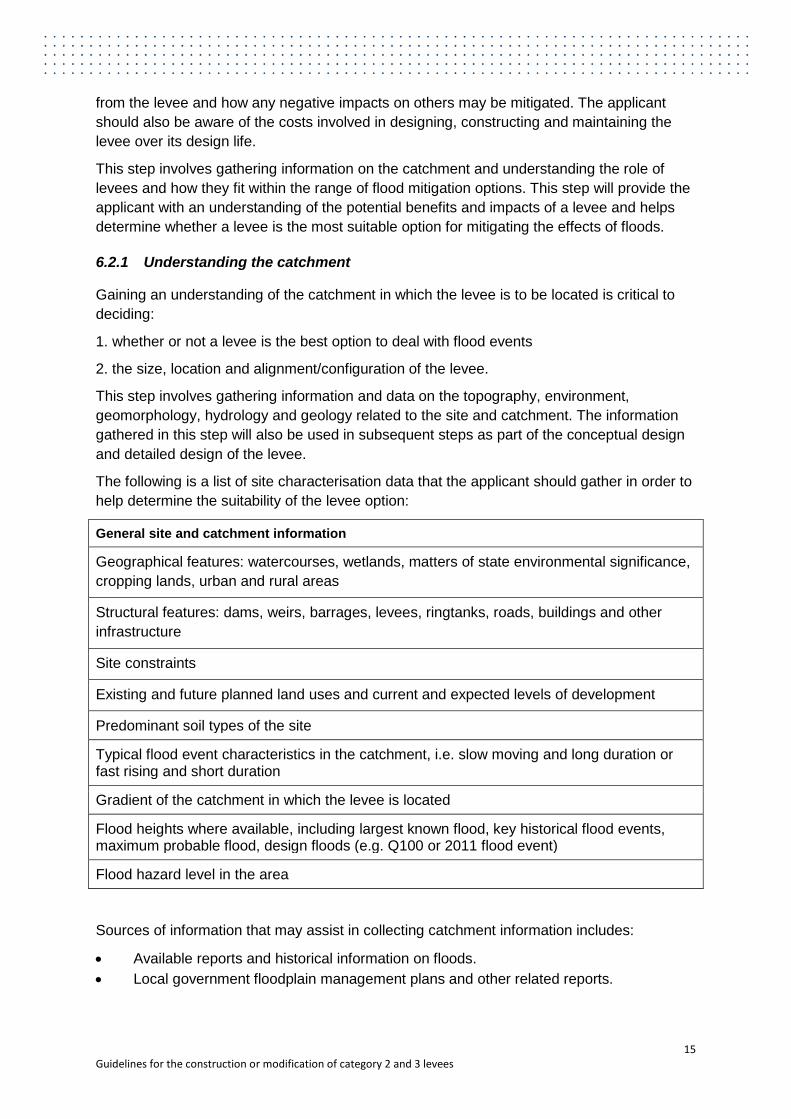
Gaining an understanding of the catchment in which the levee is to be located is critical to deciding:
1. whether or not a levee is the best option to deal with flood events
2. the size, location and alignment/configuration of the levee.
This step involves gathering information and data on the topography, environment, geomorphology, hydrology and geology related to the site and catchment. The information gathered in this step will also be used in subsequent steps as part of the conceptual design and detailed design of the levee.
The following is a list of site characterisation data that the applicant should gather in order to help determine the suitability of the levee option:
General site and catchment information
Geographical features: watercourses, wetlands, matters of state environmental significance, cropping lands, urban and rural areas
Structural features: dams, weirs, barrages, levees, ringtanks, roads, buildings and other infrastructure
Site constraints
Existing and future planned land uses and current and expected levels of development
Predominant soil types of the site
Typical flood event characteristics in the catchment, i.e. slow moving and long duration or fast rising and short duration
Gradient of the catchment in which the levee is located
Flood heights where available, including largest known flood, key historical flood events, maximum probable flood, design floods (e.g. Q100 or 2011 flood event)
Flood hazard level in the area
Sources of information that may assist in collecting catchment information includes:
• Available reports and historical information on floods. • Local government floodplain management plans and other related reports.
15 Guidelines for the construction or modification of category 2 and 3 levees
• Queensland Reconstruction Authority mapping, aerial photography, satellite imagery and other applicable local knowledge (www.qldreconstruction.org.au).
• Consultation with relevant state and local authorities and local residents who have experienced flood events.
• Interim floodplain assessment overlay by Queensland Government. • Topographic information from aerial imagery or field survey.
6.2.2 Levees as a flood mitigation option
Floodplain management involves a range of measures including land use planning, structural controls, development and building controls and flood emergency measures.
The Floodplain Development Manual (NSW State Government, 2005) identifies three categories of flood mitigation measures:
1. Flood modification, for example, structural measures such as flood control dams, levees, retarding basins, diversions and channel improvements
2. Property modification, for example, voluntary house purchase, voluntary house raising, flood proofing buildings and flood access
3. Response modification for example, flood warning system, evacuation strategies, recovery plans and community awareness.
Structural measures, such as levees, need to be designed, constructed and maintained to appropriate standards if they are to reliably provide flood protection as part of a package of floodplain management measures. The primary objective of a levee is to provide protection against flood events.
Levees perform a vital role in reducing the flood risk for landholders and many communities in Queensland. Levees can provide protection up to a certain flood height in urban, peri-urban and rural areas. As part of a broader suite of floodplain management measures, levees can provide effective flood protection to urban areas, critical infrastructure, agricultural land and other property and assets.
Levees are often constructed to reduce the frequency of exposure of vulnerable communities to flooding and the associated impacts. The benefits of a ‘town’ levee can be significant as it can remove or at least significantly reduce the impacts of flooding up to the design event. These types of levees can save a community millions of dollars and the significant emotional and physical impacts of flooding.
Properly designed and constructed levees can also provide effective flood mitigation in rural areas. Levees can be constructed to protect rural properties and buildings, cropping land and other agricultural areas and assets. These types of levees can be built on one property by a single landowner or across a number of properties in a joint effort by a number of landowners.
There are a number of inherent risks associated with levees. Levees are designed to divert floodwaters and overland flow water elsewhere. The Queensland Floods Commission of Inquiry Final Report (QFCoI, 2012) stated that levees influence flood flows and therefore can have the following types of impacts:
• they can concentrate flows leading to higher velocities, erosion of land, loss of crops, damaged irrigation infrastructure and damaged public infrastructure such as roads
16 Guidelines for the construction or modification of category 2 and 3 levees

• they may cause floods to take new directions and increase the flood risk in other areas • if levee banks fail, damage may result to the area that they were intended to protect • levees along a watercourse can create deeper flows and higher velocities in streams
which increases the risk of bed and streambank erosion and can increase flooding problems for downstream properties.
Levees are designed to protect against a certain flood height. At some point in time levees will overtop as it is not commonly economically feasible to protect against the probable maximum flood. The result of a levee overtopping during large flood events is often flooding of the protected areas as well as exacerbated flooding of other areas.
The cumulative effects of levees can also be significant where a number of levees are constructed in a floodplain. In a number of catchments in Queensland, levees have been built by a large number of property owners. The effect of a large number of levees in a catchment can be considerable upstream and downstream.
The financial and social benefits of a levee, whether it is built to protect one landholder or a community, must be weighed up against any potential environmental and social costs. Potential disadvantages of levees are:
• An increased risk to life • The potential to attract development in the area behind the levee without an
understanding of the risks involved and sometimes leading to a vicious circle of increasing risk
• Local impacts (hydrologic/hydraulic, social, economic, environmental) • Upstream and/or downstream impacts.
The management of levees must be seen alongside a broader range of activities such as land use planning and emergency preparedness that may help to reduce the flood risk. A whole of catchment perspective is recommended as part of any levee application. Since no catchment is identical to another, there is no standard recipe of measures and instruments for reducing the flood risk.
6.2.3 Suggested outcomes for category 2 and 3 levees
There are no mandated outcomes for this step, however the following recommendations are provided for each category of levee to enable the applicant to demonstrate that the levee is a suitable flood mitigation option.
Category 2 levees
For category 2 levees, the applicant may provide a brief report as part of the application explaining which alternatives to the levee have been considered and why the preferred option is a levee. The report prepared by the applicant can include a description of the potential advantages and disadvantages that the levee could have to the applicant, to neighbouring properties, to the community and to the catchment as a whole, in the context of the catchment characteristics. This report can form part of the application and will feed into the next step on the conceptual design.
17 Guidelines for the construction or modification of category 2 and 3 levees

Category 3 levees
For category 3 levees, the applicant may provide an appraisal report, signed off by a suitably qualified person. This appraisal report should describe the alternative options that have been considered and compared these to the levee option. This process should address the potential social, economic and environmental impacts as well as the technical aspects of the proposed levee.
6.2.4 Further information
Further information on floodplain management options can be found in the references below:
• Floodplain Management in Australia. Best Practice Principles and Guidelines (SCARM, 2000), Appendix B ‘Floodplain management measures’
• International Levees Handbook, chapters 2, 3, 5 and 7, (CIRIA, 2013) • Floodplain Development Manual (NSW State Government, 2005) • Planning for stronger, more resilience floodplains (Queensland State Government
Queensland Reconstruction Authority, 2011) • Emergency Management Practice Guide 3: Managing the Floodplain (Emergency
Management Australia, 1999).
6.3 Step 2. Conceptual design of the levee
The conceptual design phase allows options for location, alignment and size to be evaluated and compared, in order to ultimately identify the optimal levee solution for maximising the benefits and minimising the impacts. The outputs of this phase will feed into the detailed design phase.
The purpose of this step is for the applicant to consider that the size, location and position are suitable for the purposes of the levee, compared to alternative alignments. This includes testing a number of options to find the solution that provides the necessary flood mitigation while minimising the impacts. This question is about the physical footprint of the levee and associated works, while other impacts, such as the direct and indirect impact on flood risk via the levee's hydraulic performance, are addressed in subsequent steps.
As part of the conceptual design of the levee, the applicant should set the performance-related goals of the levee. The goals will typically encapsulate the benefits that the levee will deliver to the landowner and community. These goals could include:
• Reduction of flood risk for the majority of affected parties and/or up to a fixed water level
• Integration with local and regional development plans • Managing changes to the protected area, including provision of secondary benefits for
recreation and environment.
Issues for consideration in this step include:
1. For new levees: a. the design limit and the estimated flood height that the levee will protect against b. the extent of the area to be protected by the levee c. a range of potential levee alignments
18 Guidelines for the construction or modification of category 2 and 3 levees

d. the use of discrete elements (such as spillways) and other flood mitigation measures (such as channel diversions or temporary flood storage) at strategic locations
e. a range of different levee cross-sections (such as distance from waterway, levee geometry and levee crest structures).
2. In addition, for modification of existing levees:
a. local levee raising or repair, if required to bring a short section of the levee up to the same standard as the rest of the levee system
b. general levee raising or strengthening, if required to deal with a perceived increased risk of flooding.
This step is often a process of brainstorming and consultation between the applicant and suitably qualified person to determine the options and risks for levee location and size. The final decision on the alignment and size of the levee is a balance or trade-off between the positive and negative aspects of each issue, and between the costs and benefits. The identification of risks will feed into the risk assessment as part of the next steps.
6.3.1 Considerations when setting the levee location and alignment
The first aspect of levee design is often the determination of the location of the levee, as this will determine the characteristics of the environment, including the hydraulic, geomorphic and ground conditions and social and environmental factors upstream and downstream. Careful early thinking about the levee location and alignment may avoid ‘locked-in’ problems when future adjustments are needed.
When determining the most suitable location of the levee, the following considerations should be included:
• existing development and land use, including existing levees in the catchment • potential future development and land use • proximity of the levee to rivers, wetlands and other watercourses • proximity of the levee to existing high ground • proximity of the levee to occupied buildings and critical infrastructure • location of the levee in floodway, flood storage or flood fringe1 area • geomorphological processes • potential hydraulic impacts • cumulative impacts of levees and other structures in the catchment • environmental benefits • underlying ground conditions • availability of suitable construction materials • position or alignment in relation to the predominant flood flow path • potential locations of spillways and temporary flood storage areas • location and nature of existing utilities (surface, buried or aerial) • expected design life of the levee.
It is important that the levee should not worsen the impact of a flood. In many instances, this will mean not locating the levee on river frontage, but setting it back a sufficient distance.
1 These are defined in the glossary and based on the NSW Floodplain Management Manual, 2001
19 Guidelines for the construction or modification of category 2 and 3 levees

Locating levees on frontages may also impact on native vegetation and require removal of trees although in some situations the only option is to build the levee along the river frontage.
6.3.2 Considerations when setting the levee height
The design limit of the levee is typically set early on in the design process because it relates closely to the need for intervention. The design limit of the levee does not necessarily correspond to the height of the levee. It is common for an additional freeboard to be added to the levee crest level to compensate for uncertainties in hydrological or hydraulic design, future settlement or to provide an extra margin against overtopping flow.
As a first step, the applicant should contact their local government to check whether a floodplain management plan (FMP) has been developed or whether there are any other plans or policies in place that will influence the height at which the levee can be built. The FMP will include flood levels and a design limit. Advice can be sought from the local government regarding appropriate design limits in relation to the design limits specified in the FMP.
In Queensland, the general standard for land use planning is based on providing protection against a 1 per cent annual exceedance probability (AEP) flood (or a 1 in 100 year average recurrence interval). This is the common standard for residential buildings for example. For levees, a 1 per cent AEP is common, although in some cases a higher or lower return exceedance probability is used.
While the 1 per cent AEP may be a useful general guide, it is important that policy makers should review this risk level and adopt a suitable flood probability based on an acceptable risk for different locations, land use and infrastructure in the floodplain. For more information, refer to the Planning for stronger, more resilient floodplains (Queensland State Government Queensland Reconstruction Authority, 2011).
Higher AEPs may be required for high risk levees to protect against much rarer and hence extreme events. Levees in relation to mining activities, for example, although exempt from this regulation, can be built to protect against a 1 in 1000 year flood event. This is primarily to protect against the flooding of a mine site and the risk of hazardous materials contaminating watercourses, ecosystems and infrastructure.
If no FMP exists that covers the applicant’s property, the applicant is responsible for setting their own design limit. The design limit should be appropriate for the potential consequences of flooding.
When selecting the design limit of the levee, the following factors need to be considered:
• safety • resilience (for example to overtopping) • required level of service for hydraulic performance • the need to reduce potential flood damage based on a risk assessment process • regional planning goals • maintenance requirements • construction and operating costs • legal and statutory requirements • convenience or nuisance reduction requirements
20 Guidelines for the construction or modification of category 2 and 3 levees

• aesthetics.
Based on the design limit, it is possible to make an early estimate of the crest height and the associated approximate width. It is important to do this at an early stage in the design process in order to inform the corridor width. As part of establishing the corridor width for new levees or levee modification projects, where practical, consideration should be given to establishing no-construction zones that extend beyond the levee toes. These zones protect the levee from incursions and damage, make the process of levee inspections easier, provide easier access and working conditions in the case of an emergency or future maintenance and make the levee adaptable in case future developments require an increase to the levee’s height and width.
6.3.3 Preliminary risk assessment
As options for size and alignment are considered, the potential impacts of the levee can be estimated. At this stage, the preliminary risk assessment can be qualitative. A comprehensive impact assessment will be undertaken as part of the detailed design phase.
The purpose of undertaking an initial assessment of the impacts is to allow the applicant to discuss the implications of the levee construction or modification with neighbours, other impacted parties and the local government. Depending on the risk assessment, the design, size and alignment of the levee options can then be adjusted if necessary, prior to starting on the detailed design phase.
6.3.4 Outputs of the conceptual design phase
Recommended outputs for this step include:
• Performance-related goals of the levee • Site map showing:
o the location of the proposed works o options considered including size and alignment o existing works that affect the flow of overland flow water and/or floodwaters o lot boundaries and descriptions o position of any watercourses and water bodies o position of any roads o position of neighbouring occupied buildings
• Qualitative assessment of the benefits and impacts for the selected levee options.
6.4 Step 3. Consultation
The conceptual design phase will provide information to allow the applicant to consult with neighbours, other potentially impacted parties and the local government. Informing neighbours and the local government about the intention to build the levee and its location and design options will allow feedback to be obtained before the more resource intensive and costly detailed design and hydraulic assessments are undertaken.
The opportunity for input by neighbours and local government may allow for alterations to the conceptual design that will minimise impacts on others and the environment. This may also avoid disagreement down the track when the application is submitted.
21 Guidelines for the construction or modification of category 2 and 3 levees
If agreement is not made with the neighbours on the conceptual design, there is an option to engage a mediator at this stage to find a suitable solution.
Consultation at this stage should focus on the outputs of the first two steps:
• the rationale for the levee as the most suitable option for mitigating floods • the range of levee size and alignment options under consideration • the estimated extent of impacts from the different options • any proposed mitigation measures to manage the expected impacts.
6.4.1 Pre-lodgement meeting with the assessment manager
If applicable, the applicant may wish to hold a pre-lodgement meeting with the relevant assessment manager from the local government to discuss the conceptual design options. This meeting is designed to review the options and the associated benefits and costs and discuss the next steps and related expectations and costs.
It may be helpful as part of the pre-lodgement meeting to prepare a justification report describing the height of the flood that the levee will protect against and the benefits that the preferred location and alignment will deliver to the applicant, such as the size of the area that is protected and the protected assets or property. The report can also describe the alternatives for the size, location and position that have been considered and why the proposed alignment is a suitable solution. Basic maps and details can be used to demonstrate the options and final alignment of the levee.
The results of any consultation undertaken should also be discussed at this stage.
The purpose of this step is to seek input from the assessment manager on the design and location of the levee. This is to ensure that, where applicable, the following aspects are identified and discussed:
• relevant floodplain management plans and studies • land use planning implications • preliminary levee size, location and alignment • appropriate consultation requirements • potential impacts and mitigation measures • emergency response requirements.
This step will also seek to identify any issues that may need to be addressed in the detailed design phase. It will provide the applicant with the opportunity to discuss options and implications with the assessment manager, prior to undertaking the more resource intensive and expensive detailed design phase. This step will provide the applicant with an indication of the suitability of the application and an understanding of their requirements and responsibilities under IDAS.
It should be noted that this step will not guarantee approval of the application once the detailed design is complete. The approval of the development application will be subject to the outcomes of the detailed design phase, comprehensive risk assessment, levee categorisation, as well as the requirements under IDAS.
22 Guidelines for the construction or modification of category 2 and 3 levees
6.5 Step 4. Detailed design phase: hydrological/hydraulic assessment
During the detailed design phase the design criteria are finalised and further site assessment and modelling is undertaken to establish the hydraulic and geotechnical conditions for design and to analyse the impacts of the levee.
Similar to the conceptual design phase, this step will be an iterative process between the design options, impact identification and mitigation measures. Consultation with local government, neighbours and other impacted parties should also occur throughout this phase as more information is gathered and a better understanding of the impacts is gained.
Among the outcomes of this phase are:
• a hydrological/hydraulic assessment which will be used to help determine the assessable development category
• impact mitigation options to ensure the impacts of the levee are minimised and acceptable as part of PO 1 of the code
• design and construction specifications as part of PO 2 of the code.
The differences between a hydraulic and hydrologic assessment are as follows:
• A hydrologic assessment is the study of water and its constituents as they move through the natural processes that constitute the hydrological cycle (i.e. rainfall, runoff, evaporation, infiltration).
• A hydraulic assessment is the study of the flow of water in waterways, in particular, the evaluation of flow parameters such as water level, extent and velocity.
The level of complexity of the assessment will be dependent upon the likely risk the levee poses and the data available.
This step will involve the use of design standards and codes of practice where necessary, and a list of these is included in the references section in Appendix B. A suitably qualified person will also have access to relevant standards and expertise for levee design and construction.
Sufficient site data needs to be gathered, including ground investigation works to establish a conceptual site model and geotechnical parameters for the full detailed design of the levee.
The hydrologic/hydraulic study of the levee, also referred to as a flood impact assessment, includes modelling to determine what changes in water level, velocity and flow direction will occur as a result of building the levee. The assessment will answer the following questions:
• Does the levee increase flood risk elsewhere. • Is the increase acceptable. • Will the increase be mitigated and how.
6.5.1 Contents of a hydrological/hydraulic assessment
The detail and technical complexity of a hydrologic/hydraulic report will be proportional to the scale and potential significance of the levee project. The suitably qualified person will have sufficient experience to judge the detail and complexity of the study.
The following requirements are provided as a guide to what a hydraulic study should include:
23 Guidelines for the construction or modification of category 2 and 3 levees
• Background site data
o catchment and sitemaps o photographs o information on geographical and structural features
• Existing / historic data
o rainfall and streamflow gauging o map with historical flood marks, flood extents and depths of flood events o information (anecdotal, photographic, survey) o recorded data
• Methodologies
o design river flood flows and/or flow hydrographs o adopted hydraulic modelling method o appropriate input data, calibrated and validated to observed/recorded data (gauging
station levels / historical (epigraphic) flood levels) o joint probability analysis (if appropriate) o appropriate sensitivity analysis
• Elements of a hydraulic assessment
o identification of the source/type of potential flooding o assessment of appropriate design flows and levels at the subject site and upstream
and downstream of the site o plan extent, depth and any flood pathway indicated on a map for appropriate return
periods o assessment of likely rate of inundation, and associated flooding of specific features o plans and description of structures that may influence hydraulics o hydraulic information on any culverts or drains (existing or proposed) o estimates of climate variability impacts on probabilities, flood depths and extents o impact of the levee on flooding elsewhere (upstream, downstream and adjacent
areas) o contribution of the levee to cumulative impacts on a catchment or sub-catchment
scale o an assessment of the potential impacts on the environment (ecology, habitat,
morphology).
• Conclusions—the report should conclude with a summary of the findings and how, in the applicant’s view, these comply with the requirements of the code and the appropriate regulations.
6.5.2 Modelling
The hydraulic model developed for the levee must be capable of accurately determining flood levels, extents and velocities for given flow conditions. Where possible, the model should be integrated with existing models in the catchment.
There are a range of techniques and assessments that could be carried out by the applicant or a suitably qualified person.
For hydrological assessment these include:
24 Guidelines for the construction or modification of category 2 and 3 levees
• Site-specific flood frequency analysis • Regional flood frequency • Hydrological (rainfall/runoff) modelling
For hydraulic assessment these include:
• Simple Mannings calculations • 1D steady state hydraulic modelling (e.g. HEC-RAS) • 2D fully hydrodynamic modelling (e.g. MIKE-21, TUFLOW, RMA-2)
For levees that pose a significant risk, it is recommended that robust hydrological investigations are carried out including (depending on data availability and quality) a combination of flood frequency analysis and rainfall / runoff modelling and for hydraulic modelling detailed 2D hydrodynamic modelling is carried out to define:
• peak flood water levels • flow distribution on the floodplain • velocity distribution on the floodplain and channel(s).
6.5.3 Hydraulic assessment process
A typical hydraulic assessment process for a levee includes the following requirements:
• develop hydrologic and hydraulic models of the catchment • assess the range of floods under the pre-levee conditions using the flood models • assess the flooding associated with identified levee options using the flood models.
The levee proponent should consult relevant methodologies for hydraulic assessments. As an example, the steps that should be undertaken for a category 3 levee proposal are:
1. Review existing flood studies and available models 2. Collect available data 3. Develop and calibrate a hydrologic model for the catchment 4. Undertake a flood frequency analysis (FFA) 5. Reconciliation of the hydrologic model and the FFA results to derive design flood
hydrographs for the 20, 50, 100, 200, 500, 1000 and 10000 year ARI design flood events, as well as the probable maximum flood design event
6. Develop hydraulic model for the catchment 7. Calibrate the hydraulic model (using same flood events as in hydrologic model) 8. Assess the extent and impact of flooding under existing floodplain conditions (pre-
levee) for the range of design events described above 9. Assess the impact of flooding for the identified levee options.
The hydraulic assessment will feed into the next steps associated with impact assessment and detailed design.
6.5.4 Linking with existing models and studies
When undertaking a hydrological / hydraulic study the applicant should make best use of existing data (hydrologic, topographic) studies and models. If existing studies and findings are relied upon in the application, both the applicant and assessment manager will need to
25 Guidelines for the construction or modification of category 2 and 3 levees
be satisfied that the aims and objectives of the original studies are compatible with that of the required flood impacts study for the levee application.
As part of the requirements for the State Planning Policy (Queensland State Government Department of State Development, Infrastructure and Planning, 2013a) local governments need to identify and map flood hazard areas. More information on the requirements can be found in the State Planning Policy and the accompanying State Planning Policy: State interest—natural hazards (Queensland State Government Department of State Development, Infrastructure and Planning, 2013b).
6.6 Step 5. Detailed design phase—levee categorisation and impact acceptability
The modelling and assessment undertaken above should provide the information necessary to determine whether or not the levee will be category 2 or 3. The performance outcomes that will need to be addressed and the level of information that the assessment manager requires should have also been identified.
6.6.1 Calculating the affected population
As mentioned in section 4.2 above, for levees that have off-property impacts, a risk assessment is required to determine the impacts of the proposed levee on people, property and the environment. As part of this risk assessment, the affected population will need to be calculated in order to classify the levee as category 2 or 3. Affected population, for a levee, means the total number of persons occupying the building or buildings on which the levee has a significant impact.
A significant impact for a levee on a building means each of the following:
• an increase, caused by the levee, of more than 5cm in the flow height of water over the floorboards of the building
• an increase, caused by the levee, of more than 0.2m/s in the flow velocity of water over the height of the floorboards of the building.
The models to determine the impact on occupied buildings should be run against a range of scenarios. This sensitivity analysis should be appropriate for the size and location of the levee. The flood events should include a range of floods up to the flood protection height of the levee and a range of events that exceed the levee height.
The models will show the extent of inundation, flood heights and velocities associated with the different levee options and flood events. The incremental change to flow velocity and height will determine the number of occupied buildings that are affected by the construction or modification of the levee.
The incremental change is identified by comparing the results of the modelling of the flood extent and impacts under existing pre-levee conditions or before modification of the levee with the flood extent and impacts after the construction or modification of the levee. The number of occupied buildings affected by above floor flooding for pre and post levee will indicate the category of levee. Figure 6.1 shows a simplified illustration of the pre and post-levee impacts.
26 Guidelines for the construction or modification of category 2 and 3 levees

Appendix E assigns default populations to the affected occupied buildings. If the number of impacted people is less than 3, the levee is a category 2 levee and code assessable. If the number of people is 3 or more, the levee is a category 3 levee and impact assessable. An example of a detached house is provided in the example below.
Detached house example
A detached house has a default population of 2.9 people according to Appendix E. If more than one detached house is impacted by the levee, this will trigger a category 3 levee designation. If there is one detached house and no other occupied buildings impacted by the levee, the levee is a category 2 levee.
Figure 6.1: Simplified illustration showing number of impacted people
6.6.1 PO1 Any off-property impacts from the levee are minimised and acceptable
This section provides information on performance outcome 1 (Any off-property impacts from the levee are minimised and acceptable) of the IDAS code and contains assistance on how it can be addressed. The levee proponent is advised to seek guidance from their local council as the assessment manager on the specific expectations with regards to the level of analysis and the information to be provided to allow an assessment to be undertaken.
Performance outcome Acceptable outcome 1 Any off-property impacts from the levee are minimised and acceptable having regard to the following—
• the environment in which the levee is located
• the measures proposed to be taken to mitigate any off-property impacts
• any compensation measures for an impact proposed by the applicant
The levee does not result in— a) an unacceptable change in hydraulic
effects that occur off-property and b) an unacceptable impact on people,
property or the environment
27 Guidelines for the construction or modification of category 2 and 3 levees

Whether an impact on people or property is acceptable or not or the change in hydraulic effects is acceptable or not is dependent on the context in which the levee is built, the measures put in place to mitigate the impacts, the extent of public consultation and any compensation measures that are put in place to deal with the impacts of the levee. The acceptability of a change will typically rely on a negotiation between the applicant, the assessment manager and any impacted parties.
The decision on the acceptability of the impacts is to be made by the assessment manager. These guidelines do not provide a set of rules that will determine the acceptability for all levees across the state. Instead, the guidelines provide a set of issues that the assessment manager may consider in the decision process.
To meet the performance outcome, the levee proponent will need to provide information on the following:
• the benefits that the levee will provide to the landholder and the community • the impacts of the levee on people, property and the environment, including any cross-
jurisdictional impacts • any mitigation measures to minimise or prevent the potential impacts of the levee to
land outside the boundaries of the property • any compensation measures that have been agreed to between the landholder and
impacted parties • the extent of consultation with impacted parties • the process undertaken to identify and test levee options, risk identification and
minimisation and why the preferred option was selected.
This performance outcome is about justifying why the levee is where it is, why the benefits outweigh the costs, and what measures have been taken to ensure impacts are minimised. The levee proponent should document if and how the levee design changed in response to community concerns and how the community concerns were determined.
Box 6.1 shows an example of an output from the risk assessment that shows the number of occupied buildings affected pre and post-levee. This type of output will assist the assessment manager in assessing the acceptability of the impacts.
The risk assessment of the levee, including identification of the risks to people, property and the environment, will form a critical part of the requirement for this performance outcome. Box 6.2 provides a summary of the risk assessment of a levee as defined in the International Levees Handbook (CIRIA, 2013).
Box 6.1: Example of model outputs
One way to demonstrate the benefits and impacts of the proposed levee is to prepare tables that show for each flood mitigation option and at a number of different flood events:
• occupied buildings that do not flood with or without levee • occupied buildings that are saved from flooding by the levee • occupied buildings that now flood due to the levee • occupied buildings that flood with or without the levee (from Roma)
28 Guidelines for the construction or modification of category 2 and 3 levees

6.7 Step 6a. Detailed design phase—design specification and operations and maintenance
Performance outcome 2 of the IDAS Code deals with the design and construction standards to which the levee is to be built or modified. The guidelines present the design and construction considerations and failure mechanisms that an applicant will need to demonstrate are appropriate for the materials used and the intended function of the levee.
Performance outcome Acceptable outcome 2 The levee is a safe and stable structure
The design, construction, operations and maintenance of the proposed levee is appropriate for the materials used and levee’s intended function
6.7.1 Design specification and standards
The response to this performance outcome requires a demonstration that the proposed levee is able to provide an appropriate resistance against failure during construction, during flood events up to the design level and during the period immediately after a flood event.
Similar to previous steps, an iterative process may need to be carried out. The outline geometry is established using rules of thumb and engineering judgement. The final geometry is determined or verified by checking and fine tuning the geometry and materials to ensure that the levee can withstand relevant failure modes during its design life, is constructible and can be maintained.
This section sets out the general design considerations and failure mechanisms to address this requirement.
General design considerations include:
• levee alignment, crest level and cross-section
Box 6.2: Risk assessment of a levee (from International Levees Handbook, CIRIA, 2013)
Any risk identification process should consider the following factors:
• Loading conditions (floods and other hydro-meteorological events) and their likelihood/probabilities
• Likelihood of flood inundation without a levee breach (i.e. loading event exceeds levee crest and/or due to hydraulic or non-structural failure)
• Levee condition and its probability of breach under load (i.e. levee reliability) resulting in inundation
• Characteristics of floodplain and inundation (depth, velocity, geographical extent, etc.)
• Nature, extent and vulnerability of receptors (human, environmental, economic) to inundation
• Existing risk control mechanisms and measures and their effectiveness (e.g. emergency response)
29 Guidelines for the construction or modification of category 2 and 3 levees

• ground conditions • materials • deterioration and serviceability • transitions and other points of weakness • designing for human-induced impacts • levee construction.
Failure mechanisms:
• external erosion • seepage • internal erosion • mass instability • settlement • burrowing animals • seismic loading • underseepage • slope stability • drainage • preferred failure and diversion paths • permeability • strength • dispersiveness and erodibility • compressibility • foundation and batter surface treatments.
Levee geometry
Levee geometry can be controlled by many factors: stability during construction, performance during and after extreme events and by the minimum safe operational requirements for emergency access, maintenance and rehabilitation activities such as grass cutting. The critical geometrical features are crest level (or height above the surrounding land), crest width, side slopes (both water-side and landward side), and the dimensions of any berms.
The determination of the levee cross-section is the result of an optimisation process which starts with the geometry required by operational considerations and modifies the arrangement until a stable and serviceable configuration is achieved. Amongst other things, the cross sectional geometry will be affected by the available space (footprint of the levee) and a number of factors related to the resistance to failure mechanisms.
Availability and suitability of materials
As part of the design process, it is necessary to check that the selected fill materials meet the performance requirements. In most cases, earthworks materials for levee construction are selected through a consideration of the characteristics of the on-site materials and those from potential borrow sources. Whilst the use of selected (idealised) imported materials for levee construction may offer the best engineering performance, cost and environmental constraints may require the use of locally available soils with lower levels of performance. In this case the levee design will need to be adapted to suit the available materials. This may
30 Guidelines for the construction or modification of category 2 and 3 levees

lead, for example, to a more conservative design geometry. It is good practice to identify approved primary material sources as well as secondary sources before the commencement of construction.
The results determined from preliminary investigations should be sufficient for design, but should be verified as required during the construction process through construction field data testing analysis and verification bores.
Material availability and the identification, management and operation of suitable borrow areas is an important part of the levee design process and requires consideration of impacts on the environment and on land values. In addition, the effect on levee performance (erosion, under-seepage, uplift pressures, overall levee stability, etc.) of any borrow pits located in the immediate vicinity of the levees should be evaluated.
It is advised that a suitably experienced construction contractor is involved in the selection of a suitable borrow area at as early a stage as is possible.
Intended function of the levee
The function of the levee is to provide an impermeable barrier to the passage of water (up to a design water level) and to channel the flow of water along the existing watercourse. To fulfil this function acceptably over the design life, the levee must be appropriately stable (against every potential failure mechanism, particularly at transitions), impermeable and durable.
Failure mechanisms and deterioration modes
Potential failure mechanisms and deterioration modes that need to be considered are described below. The International Levees Handbook (CIRIA, 2013) provides a complete list and detailed description of all levee-related failure modes. Appendix D provides additional detail on how they can be managed.
6.7.1 Operations and maintenance
Levees need to be properly maintained over their design life to ensure that they function as designed during a flood event. An operations and maintenance manual may be requested by the assessment manager as part of the requirement under performance outcome 2. The assessment manager may also require as a condition of approval that the manual be updated following the final design and construction of the levee.
Setting the levee design life
The design life of the levee would have been part of the design considerations in the previous steps.
It is suggested that a minimum design life of 40 years is adopted for category 2 levees and a minimum design life of 100 years for category 3 levee. However, in some cases, a higher design life might be required, just like there might be cases where the applicant can justify a shorter design life. The following should be considered when setting the design life of a levee:
• the likelihood of significant land use change and redevelopments of existing urban and rural areas
31 Guidelines for the construction or modification of category 2 and 3 levees
• potential future changes to the levee’s strength and loading in the initial design and construction
• a monitoring / inspection program and the reservation of sufficient space to enable future raising, widening or other adaptations, if required
• the design life of the other structures which form part of the levee, such as pipes and other drainage systems – these should equal or exceed the design life of the levee.
Operations and maintenance manual
If requested, an operations and maintenance manual (the manual) should include the following requirements (based on the Levee Design, Construction and Maintenance manual (Victoria State Government, 2002)):
• a statement of the original (and current) intended function and purpose of the levee • the design details, including design flood levels, standard of protection, freeboard
allowance, mode of failure and level of failure • cross-sections • ‘as-built’ drawings • inspection schedule and requirements (periodical, during and after flood events) • maintenance of vegetation (trees) and grass cover (grazing, mowing), control of fauna
(animal burrows, cattle tracks) and vandalism • consideration of the issue of deterioration (desiccation cracking, settlement, animal
burrowing, etc.), including methods for inspecting, controlling, mitigating and/or repairing such deterioration
• details of levee-related structures, such as drainage systems and any temporary pumping that may be required
• a list of contact people and actions to be taken.
The manual should be more detailed in the description and intensity and frequency of levee inspections for higher risk levees. For example, category 3 levees may require 6-monthly periodical inspections and lower risk category 2 levee may require up to 5-yearly inspections.
The manual should be a living document. It should be updated periodically and all changes to the levee should be recorded and documented.
Inspections
Inspections should be conducted on a regular basis and may be conducted relative to a flood event (pre-event, during the event, or immediately after the event). Depending on the category of levee, recommended inspections are given below (based on International Levees Handbook, CIRIA, 2013).
• Initial inspections should evaluate and document the condition of the entire levee soon after construction. The initial inspection helps to determine the capability of the existing system to perform satisfactorily under full hydraulic loading. Initial inspections should require the operation of all aspects of the levee system to set a baseline understanding for the condition of the levee system as a whole.
• Routine inspections should provide documented evidence that the levee continues to meet minimum acceptable standards for operations and maintenance, which relate to
32 Guidelines for the construction or modification of category 2 and 3 levees

acceptable performance levels. Routine inspections are normally performed on a regular basis, for example once per year.
• ‘Inflood’ inspections are performed while the system is loaded and are extremely valuable in identifying weak or susceptible areas that could lead to a potential failure in the future. These inspections could lead to planning emergency repairs and/or initiating population evacuation. In-flood inspections should only be undertaken if they can be done safely.
• ‘Post-flood’ inspections are crucial in observing any damage which may have occurred and in evaluating the ability of the levee to withstand a future loading event. This type of inspection is also used to validate, verify and to add to information collected during the flood event. This could lead to establishing a program for urgent remedial work.
6.8 Step 6b. Community resilience
Applications for category 3 levees will be referred to the Queensland Government for assessment against the Construction or modification of levees state code, which forms part of Module 7 of the State Development Assessment Provisions (www.dsdip.qld.gov.au). The code requirements are listed below.
Performance outcome Acceptable outcome PO1 The Category 3 levee must be designed, constructed and managed such that it maintains or enhances the resilience of affected people to the potential impacts of the levee.
Editor’s note: Refer to the Guidelines for the construction or modification of category 2 and 3 levees, Department of Natural Resources and Mines, 2014 for guidance on meeting the performance outcome, including through:
a. carrying out a risk assessment of the potential impacts of the levee on the community’s resilience.
b. carrying out an analysis of the proposed mitigation measures.
c. undertaking public consultation.
No acceptable outcome is prescribed
The state interest in category 3 levees focuses on how the levee proponent can demonstrate that the levee will maintain and enhance community resilience. Resilience means the ability to adapt to changing conditions and prepare for, withstand and rapidly recover from disruption. The characteristics of a resilient community as defined in Planning for stronger, more resilient floodplains (Queensland State Government Queensland Reconstruction Authority, 2011) and the National Strategy for Disaster Resilience (NEMC, 2009) are:
33 Guidelines for the construction or modification of category 2 and 3 levees
• functioning well while under stress • successful adaptation • self-reliance • social capacity.
To meet the code requirements, the proponent will need to assess the risks that the levee may pose to community resilience and detail how the design, construction and maintenance of the levee will address these risks and contribute to maintaining or enhancing community resilience.
The following questions will need to be addressed to meet the requirement of the state code:
1. How does the design, construction and maintenance of the levee, including mitigation and/or compensation measures, contribute to community resilience and reduction in flood risk?
2. Have the identified risks associated with the levee, in particular those risks related to overtopping and failure, been integrated into relevant flood risk and disaster management processes and communicated to relevant local government and disaster management groups?
3. Have the appropriate emergency action procedures and operational and maintenance procedures been integrated into or considered as part of relevant land use and disaster management planning processes?
4. Has a vulnerability and tolerability assessment been undertaken of the population at risk from levee overtopping or failure events?
5. Has the community had the opportunity to provide input on the suitability of the levee as a flood mitigation option for addressing flood risk?
6. Has the community had the opportunity to provide input on the different levee options (i.e. locations and configurations)?
7. Is the community suitably aware of the residual risks associated with the levee and the emergency action procedures for overtopping and failure events?
8. Is the community suitably aware of the operational and maintenance requirements of the levee, including any relevant restrictions or controls on activities within the levee area?
9. Is there a plan in place to maintain community awareness and understanding of the levee risks over the design life of the levee?
10. Have the relevant local government and emergency management staff been adequately trained for preparing, responding and recovering from a levee overtopping or failure event and is there a plan in place for regular training over the design life of the levee?
For the vulnerability and tolerability assessments, more information can be found in the Planning for stronger, more resilient floodplains publication, which refers to the key elements of assessing the consequence of a flood event, as follows:
Consequence = exposure + vulnerability – tolerability
For the purposes of this State code, these elements can be considered in relation to the consequence of the proposed levee construction or modification. Criteria associated with assessing the level of exposure of the community to the levee, particularly in the case of
34 Guidelines for the construction or modification of category 2 and 3 levees
overtopping or failure, include the severity of the hazard, the size of the impacted population and the settlement pattern, land use and networks.
Vulnerability is defined as the degree of susceptibility of individual persons, the community and the environment to natural hazards, such as floods. To assess a community’s resilience, it is imperative to understand the vulnerabilities inherent in the population at risk (Australian Government, 2012). A vulnerability assessment of a community impacted by a levee includes the following criteria:
• personal safety of those potentially impacted • vulnerable persons • property impact/built form • isolation • transport linkages • critical infrastructure (e.g. hospitals, emergency services) • other infrastructure and community services.
Assessment of the tolerability of the community to a flood hazard includes these key criteria:
• community awareness and education • community attitudes and experience of flood • insurance levels • social networks and capacity • socioeconomic status • emergency plans and services, including evacuation routes and procedures • emergency volunteers • private and public business continuity.
Planning for stronger, more resilient floodplains publication (Queensland State Government Queensland Reconstruction Authority, 2011) provides more information on considerations related to community resilience and floodplain management, including a checklist in Schedule 5 of Part 2 which provides a step by step process to determine risk levels associated with floods.
6.9 Step 7. Emergency management
Performance outcome 3 of the IDAS Code deals with emergency management. This requirement is only mandatory for category 3 levees. However, it is recommended that category 2 applicants consider the applicability of the guidance provided here and apply where necessary.
Emergency action procedures will need to be prepared as part of the application for the construction or modification of a category 3 levee. The assessment manager may also require as a condition of approval that the procedures be updated following the final design and construction of the levee.
The levee proponent will also be required to refer the procedures or plan to the local disaster management group for consideration and information.
35 Guidelines for the construction or modification of category 2 and 3 levees
Performance outcome Acceptable outcome 3 Community safety is ensured in the event a category 3 levee fails or overtops
Appropriate emergency action procedures are in place for category 3 levees
As levees create risk to people in the event of overtopping or failure, there is a need for planning around warning and evacuation. The possibility of individuals becoming isolated, stranded or being swept away in the event of breach or a complete levee failure must be considered and planned for. Appropriate emergency action procedures provide information to those with operational responsibilities about what to do and why and provide the detail about how it will be done. These procedures will typically take the form of an emergency action plan .
Emergency action procedures will be dependent on:
• the range of emergency conditions (e.g. overtopping, failure) that need to be considered
• the magnitude and extent of the potential consequences of those emergency conditions
• the measures that could be taken to reduce the risk of those emergency conditions developing and
• the communication that is needed with persons whose safety or property may be threatened by emergency conditions.
Emergency action procedures or plan should include, at a minimum:
• scenario planning – impacts of the range of emergency conditions; mapping of different scenarios to show extent and depth of flooding; resources required for response; identification of immediate and secondary actions;
• communication and emergency warning protocols with the public and others with responsibilities under the procedures or plan;
• identification of key personnel required to execute the procedures or plan, including their roles, delegation of authority, responsibilities and contact details;
• evacuation planning including assembly and staging areas, evacuation routes and time required;
• levee operation, maintenance and inspection regime • surveillance during flood events to identify any faults that may be repairable and for
ensuring early warning; • health and safety risks for surveillance and emergency services personnel; • supplies and materials that may be needed to support emergency operations; and • details regarding training and exercising for the procedures or plan.
Further guidance on emergency management include:
• Emergency Management Queensland, 2012. Queensland Local Disaster Management Guidelines – Disaster Management Act 2003
• Emergency Management Australia, 1999. Emergency Management Practice Guide 3: Managing the Floodplain
• Relevant local government local disaster management plans and emergency management processes.
36 Guidelines for the construction or modification of category 2 and 3 levees
Appendix A: Glossary Affected population: for a levee means the total number of persons occupying all buildings on which the levee has a significant impact.
Annual exceedance probability (AEP): probability of exceeding a specified flow or level in any one year (CIRIA, 2013).
Average recurrence interval (ARI): the average period in years between the occurrence of a flood of a given size or larger (SCARM, 2000).
Category 1 levee: a levee that has no off-property impact.
Category 2 levee: a levee—
a) that has an off-property impact; and b) for which the affected population is less than 3.
Category 3 levee: a levee—
a) that has an off-property impact; and b) for which the affected population is at least 3.
Defined flood event (DFE): the flood event selected for the management of flood hazard to new development. This is generally determined in floodplain management studies and incorporated in floodplain management plans. Selection of DFEs should be based on an understanding of flood behaviour, and the associated likelihood and consequences of flooding. It should also take into account the social, economic, environmental and cultural consequences associated with floods of different severities (Draft State Planning Policy Guideline: State interest—natural hazards).
Existing levee: means a levee—
a) that i. was under construction when section 967 of the Water Act 2000 commenced;
and ii. has not been modified since the construction of the levee was completed or
otherwise came to an end; or b) that was existing on the commencement and has not been modified since.
Flood: relatively high water levels caused by excessive rainfall, storm surge, dam break or a tsunami that overtop the natural or artificial banks of a stream, creek, river, estuary, lake or dam (SCARM, 2000).
Flood hazard area: refer to State Planning Policy (Queensland State Government Department of State Development, Infrastructure and Planning, 2013a).
Flood protection height: the height of the maximum flood the levee is designed to protect against. The flood protection height should not include the freeboard.
Floodways: areas where a significant volume of water flows during floods and are often aligned with obvious natural channels. They are areas that, even if only partially blocked, would cause a significant redistribution of flood flow, which may in turn adversely affect other
37 Guidelines for the construction or modification of category 2 and 3 levees
areas. They are often, but not necessarily, areas with deeper flow or areas where higher velocities occur (adopted from NSW Floodplain Management Manual, 2001).
Flood storage areas: those parts of the floodplain important for the temporary storage of floodwaters during the passage of a flood. If the capacity of a flood storage area is substantially reduced by, for example, the construction of levees or by landfill, flood levels in nearby areas may rise and the peak discharge downstream may be increased. Substantial reduction of the capacity of a flood storage area can also cause a significant redistribution of flood flows (adopted from NSW Floodplain Management Manual, 2001).
Flood fringe: the remaining area of land affected by flooding after floodway and flood storage areas have been defined. Development in flood fringe areas would not have any significant effect on the pattern of flood flows and/or flood levels (adopted from NSW Floodplain Management Manual, 2001).
Freeboard: the height above a defined flood level, typically used to provide a factor of safety. Freeboard compensates for effects such as wave action, localised hydraulic behaviour and settlement of levees, which increase flood levels or reduce the level of protection provided by levees. Freeboard should not be relied upon to provide protection for flood events larger that the DFE (SCARM, 2000).
Hydraulic assessment: the study of the flow of water in waterways, in particular, the evaluation of flow parameters such as water level, extent and velocity (SCARM, 2000).
Hydrologic assessment: the study of water and its constituents as they move through the natural processes that constitute the hydrological cycle (i.e. rainfall, runoff, evaporation, infiltration) (SCARM, 2000).
Irrigation infrastructure: water infrastructure or other infrastructure constructed, erected or installed for the supply of water or the storage and distribution of water for the irrigation of crops or pastures.
Examples of irrigation infrastructure - a supply channel, head ditch or tailwater drain
Landholder: includes owners or lessees of the land on which the levee is proposed to be constructed or modified. Also referred to as levee proponent.
Levee: an artificial embankment or structure which prevents or reduces the flow of overland flow water onto or from land. A levee includes levee-related infrastructure. Refer to Attachment 1 for the list of exclusions as defined in the Water Act 2000.
Levee property: (a) means the lot or parcel of land on which a levee is situated; and (b) includes another lot or parcel of land that is contiguous with the lot or parcel mentioned in (a) and owned by the same entity.
Levee-related infrastructure: means infrastructure, including irrigation infrastructure, that is—
a. connected with the construction or modification of the levee; or
b. used in the operation of the levee to prevent or reduce the flow of overland water onto or from land. Examples of infrastructure for paragraph (b) - a channel, drain, outfall or pipe
Modify, for an existing levee, means any or all of the following:
• to raise or lower the height of the levee
38 Guidelines for the construction or modification of category 2 and 3 levees

• to extend or reduce the length of the levee • to make another change to the levee that affects the flow of water.
Off-property impact: for a levee, means an impact the levee has on a people, property or the environment outside the levee property.
Overland flow water: Refer to Schedule 4 of the Water Act 2000.
Overtopping: passing of water over the top of a structure as a result of a water level higher than the crest of the structure (CIRIA, 2013).
Prescribed farming activities means—
a. cultivating soil; or Examples - clearing, replanting and broadacre ploughing
b. disturbing soil to establish non-indigenous grasses, legumes or forage cultivars; or
c. using land for horticulture or viticulture; or
d. laser levelling or contouring soil.
Probable Maximum Flood (PMF): the largest flood that could conceivably occur at a particular location. The PMF defines the extent of flood-prone land.
Property: refer to levee property definition
Registered Professional Engineer Queensland (RPEQ): means a person registered as a registered professional engineer under the Professional Engineers Act 2002
Resilience: the ability to adapt to changing conditions and prepare for, withstand and rapidly recover from disruption.
Rural zone: refers to a zone in a local government planning scheme that is equivalent to the ‘rural zone’ of the Queensland Planning Provisions.
Significant impact, of a levee on a building, means each of the following:
a. disturbing soil to establish non-indigenous grasses, legumes or forage cultivars; or
b. using land for horticulture or viticulture; or
Suitably qualified person: a person with the necessary qualifications and experience to undertake risk assessments, hydraulic studies or the design and construction of a levee.
Watercourse: refer to the Water Act 2000 section 5.
Vulnerability: the degree of susceptibility of individual persons, the community and the environment to natural hazards, such as floods.
39 Guidelines for the construction or modification of category 2 and 3 levees
Appendix B: References Australian Government, 2012. Natural disasters and community resilience: A framework for support.
CIGB-ICOLD, 2012. Internal erosion of existing dams, levees, and dikes, and their foundations -International Glossary. CIGB-ICOLD Bulletin, (1), p.2–8
CIRIA, 2013. International Levee Handbook (ILH)
CIRIA/CUR/CETMEF, 2007. The Rock Manual - The use of rock in hydraulic engineering (2nd edition) Report C683, London: CIRIA
DEFRA & Environment Agency, 2011. Understanding the risks, empowering communities, building resilience - National flood and coastal erosion risk management strategy for England
Environment Agency, 1999. Flood and Coastal Defence Project Appraisal Guidance – Economic Appraisal www.archive.defra.gov.uk/environment/flooding
Emergency Management Australia, 1999. Emergency Management Practice Guide 3: Managing the Floodplain
Emergency Management Queensland (EMQ), 2012. Queensland Local Disaster Management Guidelines – Disaster Management Act 2003
EurOtop, 2008. Wave Overtopping of Sea Defences and Related Structures: Assessment Manual. Environmental Agency (UK), Expertise Netwerk Waterkeren (NL), Kuratorium für Forschung im Küsteningenieurwesen (DE)
Federal Emergency Management Agency (FEMA), USA, 2006. National Flood Insurance Program (NFIP), Floodplain Management Requirements: A Study Guide and Desk Reference for Local Officials
Federal Emergency Management Agency FEMA, April 2004. Federal Guidelines for Dam Safety Glossary of Terms
McCue, 1999. Australian Seismological Report – 1999
McCue, year unknown. Historical earthquakes in Queensland
McLuckie, et al, 2013. Monitoring the conditions of levees to inform decision making
NEMC, 2009. National Strategy for Disaster Resilience
NSW State Government, 2001. Floodplain Management Manual
NSW State Government, 2005. Floodplain Development Manual
Queensland Flood Commission of Inquiry (QFCoI) Final Report, March 2012
Queensland State Government Department of Energy and Water Supply 2012. Guidelines for Failure Impact Assessment of Water Dams
Queensland State Government Department of Natural Resources and Water, 2007. Queensland Urban Drainage Manual
40 Guidelines for the construction or modification of category 2 and 3 levees
Queensland State Government Department of State Development, Infrastructure and Planning, 2013a. State Planning Policy
Queensland State Government Department of State Development, Infrastructure and Planning, 2013b. State Planning Policy: State interest—natural hazards: Guidance on flood, bushfire and landslide hazards
Queensland State Government Queensland Reconstruction Authority, 2011. Planning for stronger, more resilient floodplains
SCARM, 2000. Floodplain Management in Australia. Best Practice Principles and Guidelines Report No 73, CSIRO Publishing, Collingwood, Victoria.
NFRAG, not yet available. Managing the Floodplain: A Guide to Best Practice in Flood Risk Management in Australia
RWS (Office of Public Works), 2012. Flood Risk and Water Management in the Netherlands (A2012 update)
RWS (Office of Public Works), 2006. Dutch Directive for Safety Assessment of flood defences (Voorschrift Veiligheid Toetsen (VTV))
SEPA (Scottish Environment Protection Agency), 2010. Technical Flood Risk Guidance for Stakeholders, Version 6, 30 August 2012
Victoria State Government, Department of Natural Resources and Environment, 2002. Levee Design, Construction & Maintenance
41 Guidelines for the construction or modification of category 2 and 3 levees

Appendix C: Activities excluded from the definition of levees Activity Definition How activity is currently managed
1. Prescribed farming activities
a. cultivating soil; or
Examples—
clearing, replanting and broadacre ploughing
b. disturbing soil to establish non-indigenous grasses, legumes or forage cultivars; or
c. using land for horticulture or viticulture; or
d. laser levelling or contouring soil.
Reference: Agricultural activities (including a, b and c but excluding d above) are defined in section 5 Dictionary of the Wild Rivers Act 2005. https://www.legislation.qld.gov.au/LEGISLTN/CURRENT/W/WildRivA05.pdf
Common or Dictionary definition applies to laser levelling.
Ref: Agricultural use definitions in the Queensland Planning Provisions Version 3.0, Schedule 1 under the Sustainable Planning Act 2009. http://www.dsdip.qld.gov.au/resources/policy/state-planning/qpp-3.pdf
• Prescribed farming activities are managed as in accordance with best practice guidelines. For example- Strip cropping – see http://www.regional.org.au/au/asa/1980/contributed/land-use/s4-06.htm and http://www.grazingbestprac.com.au/bestpractice/farmers/property-planning.htmlhttp://www.dsdip.qld.gov.au/resources/policy/state-planning/qpp-3.pdf Table 9.2.2.1
• Check with the relevant codes and best practices applicable in your Local Government area. Refer to the Planning Scheme of your Council for further details.
2. Fill that is used in landscaping /visual amenity / acoustic screening.
Fill is not considered as a levee, if it uses less than a volume of 50m3 of fill material. Reference - Definition of a levee (Water Act 2000)
Cut and fill is often used to improve access, to provide useable outdoor spaces, to improve visual amenity and provide acoustic screening as in accordance with the best practice guidelines. For example’ Landscape Design requirements for Education Queensland School grounds’. http://deta.qld.gov.au/corporate/pdf/landscape-design-requirements-school-facilities-school-grounds.pdf
•Check with the relevant codes and best practices applicable in your Local Government area. Refer to the Planning Scheme of your Council for further details.
3. Infrastructure used to safeguard life and property from the threat of coastal hazards.
The infrastructure used to safeguard life and property from the threat of coastal hazards within coastal management district, includes coastal protection structures like seawalls and groynes. Reference- Sections 54, 56 and Schedule (page 124) in Coastal Protection and Management Act 1995. Dictionary definition applies for seawalls and groynes. https://www.legislation.qld.gov.au/LEGISLTN/CURRENT/C/CoastalProtA95.pdf
The primary purpose of such infrastructure is to prevent bank or beach erosion.
Such infrastructure is assessed under Prescribed Tidal Works Code for development applications as assessable development.
http://www.austlii.edu.au/au/legis/qld/consol_reg/cpamr2003400/sch4a.html
State development assessment provisions Module 10.1-Tidal works, or development in a coastal management district code also applies here for the assessment of applications on such infrastructure construction. www.dsdip.qld.gov.au/resources/template/sdap/module-10-1.
42 Guidelines for the construction or modification of category 2 and 3 levees

Activity Definition How activity is currently managed
4. Structures constructed for emergency work.
(1) Levees or levee like structures could be constructed as emergency work by an applicant because of an emergency endangering:
(i) the life or health of a person; or
(ii) the structural safety of a building; or
(iii) the operation or safety of community infrastructure that is not a building; and notify (written) the assessing authority as soon as practicable after starting the construction.
Reference-Exemption for emergency development or use is defined in the section 584 of the Sustainable Planning Act (SPA) 2009.
(2) However, above provisions do not apply if the applicant is required by an enforcement notice or order to stop carrying out the development or use.
https://www.legislation.qld.gov.au/LEGISLTN/CURRENT/S/SustPlanA09.pdf
The primary purpose of the constructed structures (levees or levee-like) as emergency work is to protect life and property under emergency situations. Levees or levee like structures may be constructed as emergency work as in accordance with the best available engineering standards.
An applicant undertaking an emergency development or use, would only be required to give written notice to the assessing authority as soon as practicable after starting the development or use (refer s.584(1)(b) of the SPA). An enforcement notice or order to stop carrying out the levee construction could be applied by the assessing authority, if a levee constructed under an emergency is not up to the engineering standards or non- complying with the code provisions. https://www.legislation.qld.gov.au/LEGISLTN/CURRENT/S/SustPlanA09.pdf
5. A structure constructed under Soil Conservation Act 1986 (SC Act).
Structures under the SC Act are designed for the purpose of controlling erosion. Structures include contour banks, diversion banks and waterways. Reference- Sections 10,11,14,15 and 17 of the Soil Conservation Act 1986. https://www.legislation.qld.gov.au/LEGISLTN/CURRENT/S/SoilConservA86.pdf
A property plan details soil conservation works/measures required for an individual landholding. A Property Plan may be approved by delegated officers. A Project Plan consists of several properties within a defined catchment and co-ordinates runoff control works across land within a catchment including road/rail infrastructure. Chief Executive advertises a proposed project plan, review objections and make recommendations to the Governor-in-Council who then may approve the Plan. Appeal provisions are available for both Project and Property Plans.
6. A structure whose design takes into account the impacts of flooding or flood mitigation but which is not primarily designed for flood mitigation such as public roads
Roads and associated engineering structures designed and constructed under Transport Infrastructure Act 1994 and Planning schemes of the local government. https://www.legislation.qld.gov.au/LEGISLTN/CURRENT/T/TranstInfA94.pdf
The roads designed and constructed under Transport Infrastructure Act 1994, are being assessed under chapter 1 of the Department of Main Roads and Transport‘s Road Drainage Manual (RDM) for flood impacts.
Council roads are assessed under the relevant codes (for example ‘Stormwater Management Code’, ‘Waterway Code’ and ’Filling and Excavation Code’ in the City Plan 2000 of Brisbane City Council) of the Planning schemes, for flood impacts.
The provisions of the Queensland Urban Drainage Manual (QUDM) are also being applied to assess the flood impacts of these roads.
1.http://www.tmr.qld.gov.au/business-industry/Technical-standards- anpublications/Road-drainage-manual.aspx
2. http://www.dews.qld.gov.au/water-supply-regulations/urban-drainage
3. http://www.brisbane.qld.gov.au/planning-building/planning-guidelines-and-tools/city-plan-zones-codes/city-plan-2000-document/chapter-5-codes-and-related-provisions/index.htm
43 Guidelines for the construction or modification of category 2 and 3 levees
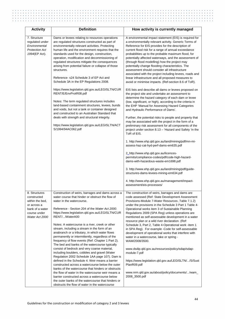
Activity Definition How activity is currently managed
7. Structure regulated under Environmental Protection Act 1994(EP Act).
Dams or levees relating to resources operations are regulated structures constructed as part of environmentally relevant activities. Protecting human life and the environment requires that the standards used for the design, construction, operation, modification and decommissioning of regulated structures mitigate the consequences arising from potential failure or collapse of those structures.
Reference- s24 Schedule 3 of EP Act and Schedule 3A in the EP Regulations 2008.
https://www.legislation.qld.gov.au/LEGISLTN/CURRENT/E/EnvProtR08.pdf
Notes: The term regulated structures includes land-based containment structures, levees, bunds and voids, but not a tank or container designed and constructed to an Australian Standard that deals with strength and structural integrity.
https://www.legislation.qld.gov.au/LEGISLTN/ACTS/1994/94AC062.pdf
A environmental impact statement (EIS) is required for a environmentally relevant activity. Generic Terms of Reference for EIS provides for the description of current flood risk for a range of annual exceedance probabilities up to the probable maximum flood, for potentially affected waterways, and the assessment of (through flood modelling) how the project may potentially change flooding characteristics. The assessment should consider all infrastructure associated with the project including levees, roads and linear infrastructure and all proposed measures to avoid or minimise impacts. (Ref-section 8.6 of ToR).
EIS lists and describe all dams or levees proposed on the project site and undertake an assessment to determine the hazard category of each dam or levee (low, significant, or high), according to the criteria in the EHP ‘Manual for Assessing Hazard Categories and Hydraulic Performance of Dams’.
Further, the potential risks to people and property that may be associated with the project in the form of a preliminary risk assessment for all components of the project under section 8.13 – ‘Hazard and Safety ‘in the ToR of EIS.
1. http://www.ehp.qld.gov.au/land/mining/pdf/mn-mi-assess-haz-cat-hyd-perf-dams-em635.pdf
2. http://www.ehp.qld.gov.au/licences-permits/compliance-codes/pdf/code-high-hazard-dams-with-hazardous-waste-em1698.pdf
3. http://www.ehp.qld.gov.au/land/mining/pdf/guide-structures-dams-levees-mining-em634.pdf
4. http://www.ehp.qld.gov.au/management/impact-assessment/eis-processes/
8. Structures constructed within the bed, or across a bank of a water course under Water Act 2000
Construction of weirs, barrages and dams across a water course that hinder or obstruct the flow of water in the watercourse.
Reference - Section 204 of the Water Act 2000. https://www.legislation.qld.gov.au/LEGISLTN/CURRENT/.../WaterA00
Notes: A watercourse is a river, creek or other stream, including a stream in the form of an anabranch or a tributary, in which water flows permanently or intermittently, regardless of the frequency of flow events (Ref: Chapter 1 Part 2). The bed and banks of the watercourse typically consist of bedrock and very coarse material, including boulders, cobbles and gravel (Water Regulation 2002 Schedule 1AA page 107). Dam is defined in the Schedule 4. Weir means a barrier constructed across a watercourse below the outer banks of the watercourse that hinders or obstructs the flow of water in the watercourse weir means a barrier constructed across a watercourse below the outer banks of the watercourse that hinders or obstructs the flow of water in the watercourse
The construction of weirs, barrages and dams are code assessed (Ref: State Development Assessment Provisions-Module 7-Water Resources ,Table 7.1.2) under the provisions in the Schedule 3 Part 1 Table 4-Operational works item 3 of Sustainable Planning Regulations 2009 (SPA Reg) unless operations are mentioned as self-assessable development in a water resource plan or a wild river declaration. (Ref: Schedule 3, Part 2, Table 4-Operational work -item 1 in SPA Reg). For example -Code for self-assessable development of operational works that interfere with water in a watercourse, lake or spring - WAM/2008/3500.
www.dsdip.qld.gov.au/resources/policy/sdap/sdap-module-7.pdf
https://www.legislation.qld.gov.au/LEGISLTN/.../S/SustPlanR09.pdf
www.nrm.qld.gov.au/about/policy/documents/.../wam_2008_3500.pdf
44 Guidelines for the construction or modification of category 2 and 3 levees

Activity Definition How activity is currently managed
(Schedule 4).
9. Waterway barrier works
Waterway includes a river, creek, stream, watercourse (as defined under Water Act 2000, schedule 4) or inlet of the sea. Waterway barrier works means a dam, weir or other barrier across a waterway if the barrier limits fish stock access and movement along a waterway .(Ref-Fisheries Act 1994) https://www.legislation.qld.gov.au/LEGISLTN/CURRENT/.../FisherA94
Operational work that is the construction or raising of waterway barrier works, other than operational work that is self-assessable development under part 2 Schedule 3 of SPA Reg or carried out on premises to which structure plan arrangements apply (SPA Reg schedule 3 Part1 table 4 –Operational work item 6) Codes for operational work for constructing or raising a waterway barrier works:
Each of the following documents, prepared and held by the chief executive, is a code for IDAS for self-assessable development mentioned in the Planning Regulation, schedule 3, part 2, table 4, item 2—
(a) the document called ‘Code for self-assessable development—Minor waterway barrier works’;
(b) the document called ‘Code for self-assessable development—Temporary waterway barrier works’;
(c) the document called ‘Code for self-assessable development—Regularly constructed temporary waterway barrier works’. (Ref :section 704-Fisheries Regulation 2008 Chapter 15 Other matters relating to fisheries management Part 3 Codes for IDAS)
https://www.legislation.qld.gov.au/LEGISLTN/.../S/SustPlanR09.pdf
https://www.legislation.qld.gov.au/.../F/FisherR08_03F_120921.pdf
10. A structure constructed for long term storage of water
Water Supply (Safety and Reliability) Act 2008 (WSA) provides for the regulation of referable dams constructed and maintained for the safety and reliability of water supply. Under section 341 of this Act:
A dam is, or a proposed dam after its construction will be, a referable dam (dam is considered referable if it would threaten life if it failed.) if—
(a) a failure impact assessment of the dam, or the proposed dam, is required to be carried out under this part; and
(b) the assessment states the dam has, or the proposed dam after its construction will have, a category 1 or category2 failure impact rating; and
(c) the chief executive has, under section 349, accepted the assessment
https://www.legislation.qld.gov.au/LEGISLTN/.../WaterSupSRA08.pdf
The failure assessment must be undertaken by a Registered Professional Engineer and is required for all dams exceeding the following criteria:
• more than eight metres high, and
• a storage capacity exceeding 500 megalitres
OR
• more than eight metres high, and
• a storage capacity exceeding 250 megalitres, and
• a catchment area which is more than three times the reservoir surface area at full supply level.
https://www.legislation.qld.gov.au/LEGISLTN/.../WaterSupSRA08.pdf
45 Guidelines for the construction or modification of category 2 and 3 levees
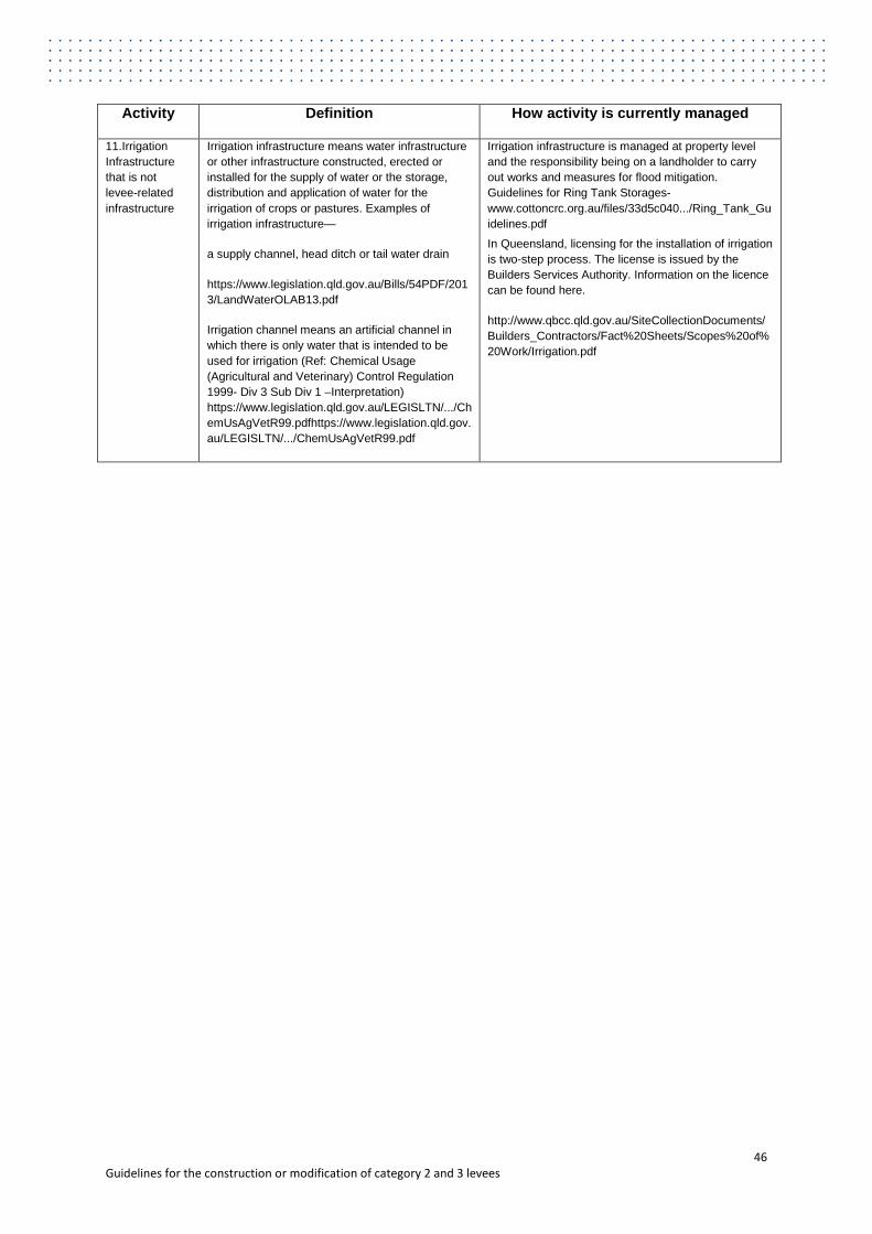
Activity Definition How activity is currently managed
11.Irrigation Infrastructure that is not levee-related infrastructure
Irrigation infrastructure means water infrastructure or other infrastructure constructed, erected or installed for the supply of water or the storage, distribution and application of water for the irrigation of crops or pastures. Examples of irrigation infrastructure—
a supply channel, head ditch or tail water drain
https://www.legislation.qld.gov.au/Bills/54PDF/2013/LandWaterOLAB13.pdf
Irrigation channel means an artificial channel in which there is only water that is intended to be used for irrigation (Ref: Chemical Usage (Agricultural and Veterinary) Control Regulation 1999- Div 3 Sub Div 1 –Interpretation) https://www.legislation.qld.gov.au/LEGISLTN/.../ChemUsAgVetR99.pdfhttps://www.legislation.qld.gov.au/LEGISLTN/.../ChemUsAgVetR99.pdf
Irrigation infrastructure is managed at property level and the responsibility being on a landholder to carry out works and measures for flood mitigation. Guidelines for Ring Tank Storages-www.cottoncrc.org.au/files/33d5c040.../Ring_Tank_Guidelines.pdf
In Queensland, licensing for the installation of irrigation is two-step process. The license is issued by the Builders Services Authority. Information on the licence can be found here.
http://www.qbcc.qld.gov.au/SiteCollectionDocuments/Builders_Contractors/Fact%20Sheets/Scopes%20of%20Work/Irrigation.pdf
46 Guidelines for the construction or modification of category 2 and 3 levees
Appendix D: Levee Failure mechanisms and deterioration modes (see section 6.7.1) Potential failure mechanisms and deterioration modes that need to be considered are described below. The International Levees Handbook (CIRIA, 2013) provides a complete list and detailed description of all levee-related failure modes.
D1. Failure mechanisms
External erosion
External erosion is the wearing away of a surface (bank, streambed, embankment, or other surface) by floods, waves, wind, or any other natural process (Federal Guidelines for Dam Safety Glossary of Terms, FEMA, 2004). External erosion is initiated by hydrodynamic forces acting on soil particles at the surface of a levee. It occurs when the surface material of the levee is not sufficiently resistant to erosion. That is, when the shear stress induced by flows, exceeds the critical value associated with the nature of the materials of the levee. This problem can arise over time because of the aging of surface materials, but it can also be due to an increasing effect of the environment on the levee (during floods, for instance).
The following mechanisms can result in external erosion:
• Overtopping leading to erosion of crest and landward slope • Hydraulic actions such as waves, currents and turbulence leading to erosion of
waterward slope and toe • Human and animal damage such as cattle (tracks), vandalism, construction, collision
(e.g. vessels and vehicles) leading to external erosion of the crest, side slopes and toe of levee.
Key considerations for overtopping to be addressed by the designer, include:
• levee crest level against design water surface profiles • overtopping flow rate (q) • landward slope steepness, top soil material and revetment properties • maintenance regime employed.
An alternative local solution to reduce the effects of overtopping can be to include a ‘low point’ or spillway, to help control extreme situations in which a levee is overtopped by ensuring that the water overtops in the least vulnerable area, combined with sufficient drainage systems to get rid of the overtopped water.
The crest level of a levee is typically set by calculating the water level in the design limit event, and adding a certain additional height (termed ‘freeboard’) to take account of uncertainty. In setting the minimum crest level the following aspects need to be taken into account:
• design life • future development (land use planning) • settlement of subsoil and levee-related structures • hydrological changes • extreme flood events up to Probable Maximum Flood (PMF).
47 Guidelines for the construction or modification of category 2 and 3 levees
Internal erosion
Internal erosion is initiated by hydrodynamic forces acting on soil particles inside or through the body of a levee. Internal erosion occurs when soil particles within a levee or its foundation, are carried downstream by seepage flow (CIGB-ICOLD, 2012). In this process, the migration of material particles is induced by elevated pore pressures and the flow of water through interstices in the soil or along channels opened by hydraulic separation. As a result, suffusion, backwards erosion and/or piping can occur, forming channels through the levee or through the foundation soils. These pipes can undermine the structure of the levee leading to crest settlement (and hence increased risk of overtopping) or to instability of the landward side of the levee (and hence possible failure and a breach.
The following mechanisms result in internal erosion:
• seepage • suffusion • hydraulic separation • backwards erosion • piping.
These mechanisms can be triggered by layers of permeable material within the levee or the levee foundation or by hydraulic separation (hydraulic fracture) along interfaces between soils and structural materials or different material types. Deterioration of the levee caused by animal burrows, desiccation cracks and tree or shrub roots, etc. can also trigger seepage and internal erosion.
Instability
Instability occurs when forces resisting failure (such as shear strength of the soils and the weight of any berm) are exceeded by the applied forces (the applied hydraulic actions, crest loads, the mass of the levee itself etc.). Excessive external loading on a levee (such as that due to a flood) and weak physical properties of the levee materials or the foundation soils, can generate sliding along a shear surface within the levee embankment and/or foundation soils. These processes are related to mechanisms such as rotational or translational sliding of the whole of the levee or part of the levee.
Particular levee failure mechanisms can include:
• levee failure during construction • land side slope instability, particularly during a flood • uplift of landward toe during a flood event leading to instability • water side slope instability, particularly rapid drawdown after a flood • liquefaction during a seismic event.
Deterioration and failure modes related to transitions
Earthen levees can be relatively flexible structures. This brings advantages in that they are able to settle and potentially distort as the underlying ground consolidates under their weight over time. However, this process of settlement will result in a lowering of the crest level and hence a reduced standard of defence. Particular problems can occur if the settlement is
48 Guidelines for the construction or modification of category 2 and 3 levees
localised; this will result in differential settlement which could initiate cracking. The localised settlement will create a ‘low spot’ which will be vulnerable to the preferential overtopping which would occur at this location.
It is the role of the designer to determine the magnitude and location of settlement resulting from consolidation and compaction of the ground, to identify the possibility of differential settlement and to control these aspects of performance through appropriate design measures.
Performance problems can also be created if rigid structures such as crest walls, pipes and spillways are incorporated into the levee.
Problems that can be triggered by incorporating non-earthwork structures into levees include:
• differential settlement • external erosion • instability • hydraulic separation.
Hydraulic separation is the potentially dangerous process by which a flow path is created (sometimes suddenly) between a rigid structure and poorly compacted or low strength fill material by the action of the pressure of the flood water. It is not straightforward to address, and thus the number of interfaces between rigid elements and fill should be minimised. Again, it is the designer’s role to anticipate and address these issues as part of the design process.
D2 Modifications of existing levees
It has to be noted that some modifications that have a positive effect on one of the mechanisms, might have a negative influence on another mechanism. For example, when raising the crest level to reduce overtopping, the following has to be considered:
• The additional weight of the fill used for levee raising may have a destabilising effect on the existing levee, which could result in sliding of the land- or waterward slope.
• The greatest thickness of fill material placed is often to the landward side of the original crest and this is the location where short term undrained failure mechanisms may initiate, e.g. during or shortly after construction.
• The magnitude of the settlement caused by the levee raising should be assessed and any anticipated differential settlement controlled by appropriate measures, such as careful control of the landward slope or the use of geofabrics.
A good connection between the existing levee and the new fill material is necessary to ensure that the new fill does not slide down the existing landward slope, and the interface between the old and the new fill does not create a path for seepage. One way to achieve this is to remove the existing topsoil and vegetation from the crest and the landward slope and then create a series of steps on which the new fill is deposited and compacted.
D3 Assessment steps for failure mechanisms
This section describes specific assessment steps for seven mechanisms and characteristics. Potential failure mechanisms, deterioration mechanisms and certain levee-related structures need to be recognised and managed by a combination of experience and calculation.
49 Guidelines for the construction or modification of category 2 and 3 levees

Each mechanism below is structured around a tiered assessment process. Step 1 allows the levee applicant to use simple rules of thumb to identify modes for which the levee clearly complies or does not comply, without the need for detailed assessment. These rules of thumb are intended to be more conservative than normal design rules. However, the rules cannot anticipate every potential failure system. For this reason, the rules of thumb are set only to indicate which levees require assessment; they are not a guarantee of performance.
Responsibility of any levee remains with the levee applicant or designer and the constructor regardless of the levee category. If the levee does not comply with the rules of thumb or when the assessment manager is not certain if the rules of thumb comply (for example when these are not signed off by a suitably qualified person), the assessment continues with Step 2.
Step 2 consists of checking whether all key considerations (formulated as questions) of that particular mechanism, have been identified for the proposed levee design. If not, the levee cannot be compliant. If the answer is yes, the assessment continues with Step 3, the technical assessment of each of the key considerations.
Step 3 requires a detailed assessment (with calculations if applicable) for each identified consideration. If the levee applicant demonstrates that each consideration, separately and in combination with the other considerations, meets an acceptable level of risk reduction, then the levee is compliant with performance outcome 2 for that particular failure mode. If the assessment manager is unsure of the level of risk reduction, then all key considerations as listed under Step 2, have to be addressed and signed off by a suitably qualified person.
For high risk levees (Category 3) the assessments of the failure mode should always be signed off by a suitably qualified person.
Overflow and overtopping
Step 1 – Rules of thumb:
• If the crest level is less than 0.3m above the design water level, the levee is noncompliant.
• If the crest level is more than 0.5m above the design water level, which has been calculated with approved methods and sufficient data, and the crest level is more than 8 * wave height * tan(slope angle) above the design water level, the levee is compliant.
Step 2 – Have the following issues been considered in setting the crest level:
• design water level • allowance for uncertainty (‘freeboard’) • settlement for the design life • changes in hydraulic and physical loads for the design life (e.g. with regards to climate
variability and land use planning) • overtopping flow rate in relation to landward slope erosion and discharge capacity.
Allowances for freeboard and settlement should be added to the target crest level.
Step 3 – If the levee does not comply with the rules of thumb the following activities should be used to confirm the required freeboard:
• detailed assessment of water level uncertainty to confirm that the likelihood of steady overflow in design conditions is acceptably small
50 Guidelines for the construction or modification of category 2 and 3 levees

• detailed assessment of wave run-up / overtopping, also in relation to the erosion resistance of crest and landward slope.
Slope Stability
Step 1 – Rules of thumb:
• If the landward slope is flatter than 1V:4H and the crest width is wider than 3m, the levee is compliant
• If the landward slope of the levee is steeper than 1V:1H and made out of earthen material, the levee is non-compliant.
It is not recommended to use less conservative rules of thumb or clearly differentiate between Category 2 and 3 levees, because the slope stability is dependent on many factors, including:
• types of material • arrangement of material • state of compaction of the materials • nature of the foundation soils • width of the levee • hydraulic conditions during a flood.
Step 2 and 3 – The assessment of the slope stability always requires stability calculations, unless the levee complies with the rules of thumb mentioned under Step 1.
Different types of methods can be used to verify the stability, depending on the complexity of the levee and the perceived level of risk:
• Stability charts can be used to estimate the factor of safety of simple geometries and ground conditions.
• Hand calculations can be used to establish the stability of slopes against shallow slips. • Limit equilibrium slope stability programs are widely used and recommended for
category 2 and 3 levees. They allow the user to determine the factor of safety of complex geometrical arrangements, and extensive combinations of soil types, soil characteristics and ground water conditions. A critical slip surface is identified by determining the factor of safety for a large number of potential failure mechanisms and establishing the lowest one.
• Finite Element methods are based on a numerical continuum, which have the benefit of finding their own failure mechanisms. They can be highly sophisticated models but this can make them expensive to run and difficult to check.
The following questions should be considered:
• Has the stability during construction and after a flood event (rapid drawdown of the water level) been considered, besides the stability during the design flood?
• Is the schematisation of the subsurface based on (adequate) ground investigation (borings, in situ tests such as cone penetration tests, sampling, laboratory testing, etc.)?
• Are the material properties (volume weight, cohesion and angle of internal fraction) based on soil testing, or have conservative properties been applied?
• Are the calculations based on appropriate water levels and pressures?
51 Guidelines for the construction or modification of category 2 and 3 levees
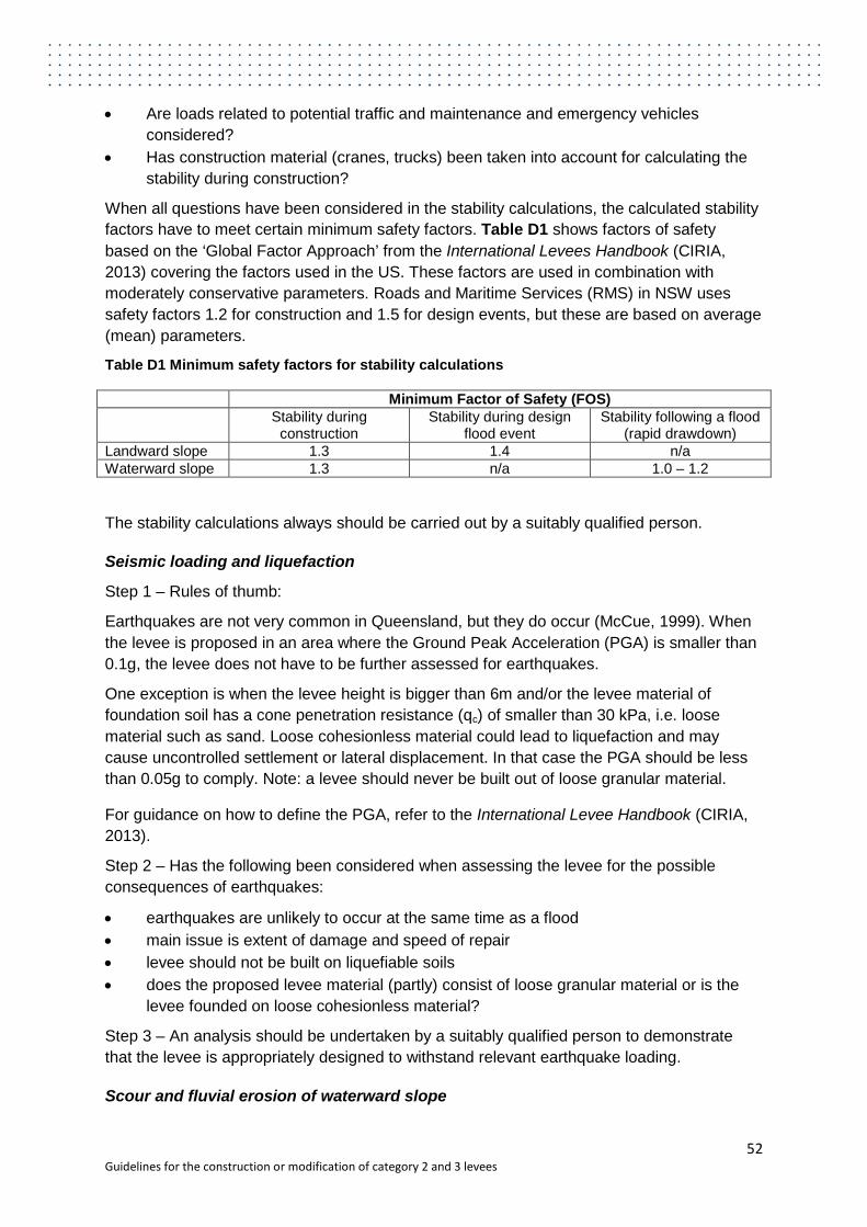
• Are loads related to potential traffic and maintenance and emergency vehicles considered?
• Has construction material (cranes, trucks) been taken into account for calculating the stability during construction?
When all questions have been considered in the stability calculations, the calculated stability factors have to meet certain minimum safety factors. Table D1 shows factors of safety based on the ‘Global Factor Approach’ from the International Levees Handbook (CIRIA, 2013) covering the factors used in the US. These factors are used in combination with moderately conservative parameters. Roads and Maritime Services (RMS) in NSW uses safety factors 1.2 for construction and 1.5 for design events, but these are based on average (mean) parameters.
Table D1 Minimum safety factors for stability calculations
Minimum Factor of Safety (FOS) Stability during
construction Stability during design
flood event Stability following a flood
(rapid drawdown) Landward slope 1.3 1.4 n/a Waterward slope 1.3 n/a 1.0 – 1.2
The stability calculations always should be carried out by a suitably qualified person.
Seismic loading and liquefaction
Step 1 – Rules of thumb:
Earthquakes are not very common in Queensland, but they do occur (McCue, 1999). When the levee is proposed in an area where the Ground Peak Acceleration (PGA) is smaller than 0.1g, the levee does not have to be further assessed for earthquakes.
One exception is when the levee height is bigger than 6m and/or the levee material of foundation soil has a cone penetration resistance (qc) of smaller than 30 kPa, i.e. loose material such as sand. Loose cohesionless material could lead to liquefaction and may cause uncontrolled settlement or lateral displacement. In that case the PGA should be less than 0.05g to comply. Note: a levee should never be built out of loose granular material.
For guidance on how to define the PGA, refer to the International Levee Handbook (CIRIA, 2013).
Step 2 – Has the following been considered when assessing the levee for the possible consequences of earthquakes:
• earthquakes are unlikely to occur at the same time as a flood • main issue is extent of damage and speed of repair • levee should not be built on liquefiable soils • does the proposed levee material (partly) consist of loose granular material or is the
levee founded on loose cohesionless material?
Step 3 – An analysis should be undertaken by a suitably qualified person to demonstrate that the levee is appropriately designed to withstand relevant earthquake loading.
Scour and fluvial erosion of waterward slope
52 Guidelines for the construction or modification of category 2 and 3 levees
Step 1 – Rules of thumb:
• If a grass cover or other form of protection is designed and sustainable (regarding climate conditions) and the calculated depth-averaged flow velocity at the levee toe is less than 1m/s (to be verified), the levee complies.
• If there is no cover (only soil) and the flow velocity is more than 3m/s (to be verified), the levee is non-compliant.
Step 2 – The following issues should be considered as a minimum:
• Hydraulic actions such as waves, currents and turbulence can lead to erosion of the waterward slope and toe. Is the water body (e.g. river) on the water side of the levee narrow enough, so that hydraulic action can be neglected?
• If not, are the waterward toe and slope appropriately resistant against hydraulic action?
• Are wave attenuating measures proposed in front of the levee, such as emergent and submerged breakwaters, to limit wave run-up and overtopping?
• Are any hydraulic obstructions on the water side present (planned), such as trees, bridge piers, walls and pipes that could worsen local erosion or scour?
Step 3 – The potential for surface erosion or scour of a levee is determined by:
• calculating current velocities and/or wave action on the waterward levee face and overflow velocities or wave overtopping characteristics on the landward face; and
• comparing these values to allowable limits for the materials. Movement (erosion) can be expected if calculated values exceed allowable limits for the levee material or protection system.
Once it has been determined that erosion and/or scour is a concern for levee safety, it is necessary to consider measures that can reduce or mitigate the effects. Suitable references (e.g. CIRIA/CUR/CETMEF, 2007) should be consulted for further information on possible surface protection measures.
Seepage, internal erosion and piping
Step 1 – Rules of thumb.
If there are no permeable layers (e.g. sand, gravel and peat) under the levee that could be in hydraulic connection with the source of water (on the waterward side), and the proposed levee material is not permeable, the risk of seepage and piping is negligible and the levee is compliant for this failure mode.
Step 2 – If permeable layers are present, a simple assessment method that could lead to compliance is the Method of Bligh (or Lane) (RWS, 2006).
The method depends on the material structure of the levee and its foundation soil. The following types can be used:
• Type 1: an embankment built out of clay or consisting of sand on poorly permeable subsoil (clay and peat layers).
• Type 2: an embankment built out of clay on permeable subsoil and the layers directly beneath the embankment’s base / sole are permeable cover layers.
53 Guidelines for the construction or modification of category 2 and 3 levees
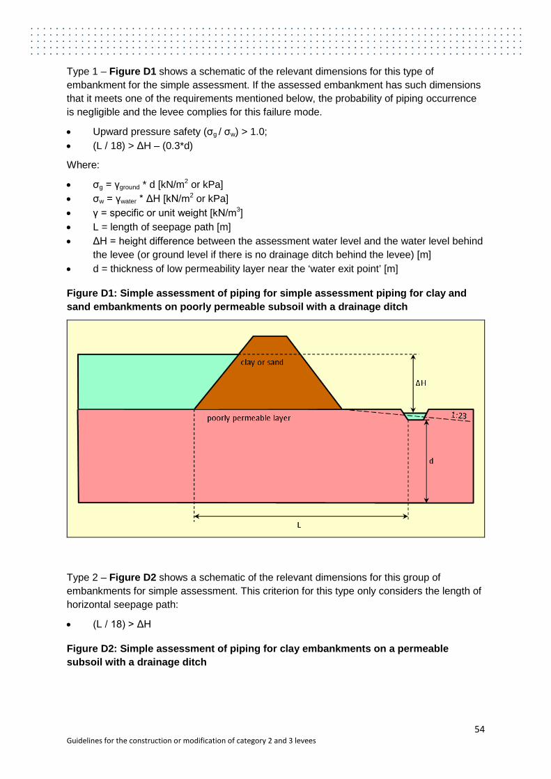
Type 1 – Figure D1 shows a schematic of the relevant dimensions for this type of embankment for the simple assessment. If the assessed embankment has such dimensions that it meets one of the requirements mentioned below, the probability of piping occurrence is negligible and the levee complies for this failure mode.
• Upward pressure safety (σg / σw) > 1.0; • (L / 18) > ΔH – (0.3*d)
Where:
• σg = γground * d [kN/m2 or kPa] • σw = γwater * ΔH [kN/m2 or kPa] • γ = specific or unit weight [kN/m3] • L = length of seepage path [m] • ΔH = height difference between the assessment water level and the water level behind
the levee (or ground level if there is no drainage ditch behind the levee) [m] • d = thickness of low permeability layer near the ‘water exit point’ [m]
Figure D1: Simple assessment of piping for simple assessment piping for clay and sand embankments on poorly permeable subsoil with a drainage ditch
Type 2 – Figure D2 shows a schematic of the relevant dimensions for this group of embankments for simple assessment. This criterion for this type only considers the length of horizontal seepage path:
• (L / 18) > ΔH
Figure D2: Simple assessment of piping for clay embankments on a permeable subsoil with a drainage ditch
54 Guidelines for the construction or modification of category 2 and 3 levees
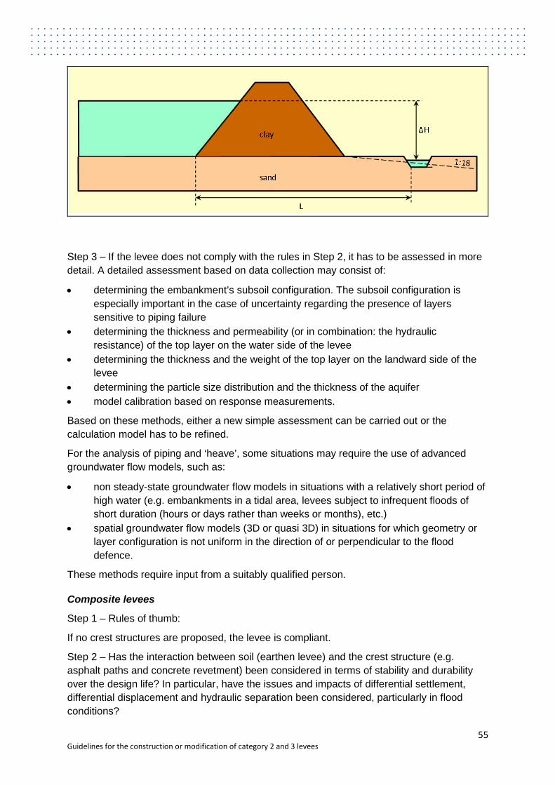
Step 3 – If the levee does not comply with the rules in Step 2, it has to be assessed in more detail. A detailed assessment based on data collection may consist of:
• determining the embankment’s subsoil configuration. The subsoil configuration is especially important in the case of uncertainty regarding the presence of layers sensitive to piping failure
• determining the thickness and permeability (or in combination: the hydraulic resistance) of the top layer on the water side of the levee
• determining the thickness and the weight of the top layer on the landward side of the levee
• determining the particle size distribution and the thickness of the aquifer • model calibration based on response measurements.
Based on these methods, either a new simple assessment can be carried out or the calculation model has to be refined.
For the analysis of piping and ‘heave’, some situations may require the use of advanced groundwater flow models, such as:
• non steady-state groundwater flow models in situations with a relatively short period of high water (e.g. embankments in a tidal area, levees subject to infrequent floods of short duration (hours or days rather than weeks or months), etc.)
• spatial groundwater flow models (3D or quasi 3D) in situations for which geometry or layer configuration is not uniform in the direction of or perpendicular to the flood defence.
These methods require input from a suitably qualified person.
Composite levees
Step 1 – Rules of thumb:
If no crest structures are proposed, the levee is compliant.
Step 2 – Has the interaction between soil (earthen levee) and the crest structure (e.g. asphalt paths and concrete revetment) been considered in terms of stability and durability over the design life? In particular, have the issues and impacts of differential settlement, differential displacement and hydraulic separation been considered, particularly in flood conditions?
55 Guidelines for the construction or modification of category 2 and 3 levees
Step 3 – A proper assessment of the consideration should be carried out by a suitably qualified person.
Transitions
Step 1 – Rules of thumb:
If no transitions are proposed, the levee is compliant.
Step 2 – Has the following been considered:
• Have transitions of the levee with for example higher ground been considered? • Have transitions of the levee with non-earthwork structures (e.g. spillways, pipes,
drainage systems) been considered?
Note that failures of levees often happen around local irregularities and transitions. This is often caused by poor detailing of crest structures or transitions. These become points of weakness.
Pipes – The preferred solution is to carry the pipe or conduit over the levee and avoid disturbance of the levee body, even though this could still lead to external erosion. If this is not the case in the proposed design, the following issues should be considered:
• erosion due to increased turbulence • leakage due to seepage and hydraulic separation • differential settlement between levee and pipe • seepage and internal erosion.
Crest walls and embedded walls – the following key issues should be considered:
• stability of both the composite structure and the crest structure itself, against overturning, sliding and rotational failure and seismic action
• differential settlements and movements, particularly during a flood which could lead to failure of the crest structure
• performance of the structure if overtopped, including external erosion of the levee body (this can remove the passive resistance of the crest structure leading to failure)
• external erosion of the levee body to landward or waterward leading to loss of support for the wall.
56 Guidelines for the construction or modification of category 2 and 3 levees

Appendix E: Default populations for occupied buildings2
Nature of buildings or other places of occupation Equivalent population
Detached housing 2.9 per house
Semi-detached, row or terrace housing 2.0 per house
Multi-unit buildings 1.7 per unit
Blocks of flats 1.7 per flat
House or flat attached to a shop, office, etc. 2.5 per house or flat
Approved caravan parks 1.8 per caravan site
Approved camping grounds 0.45 per camping site
Hotel/motel accommodation 1.0 per bedroom
Child care centres 0.4 per child and staff member
Kindergartens, pre-schools 0.25 per student and staff member
Primary schools (day) 0.25 per student and staff member
High schools (day) 0.3 per student and staff member
Tertiary education centres
Lectures—day 0.35 per student and staff member attending during the day
Lectures—evening 0.15 per student and staff member attending during the night
Offices 0.4 per employee
Restaurants 0.3 per member of staff and diners’ places
Medical centres 1.7 per member of staff
Mines Total of all personnel working in inundated area where the path to escape the inundation will be cut-off by the incoming flows.
Tavern/hotel bars 0.15 per m2 of patrons’ area
Shops, shopping centres 2.0 per 100 m2 of gross area
2 This is modified from the Guidelines for Failure Impact Assessment of Water Dams, Queensland Government Department of Energy and Water Supply, 2012
57 Guidelines for the construction or modification of category 2 and 3 levees

Hospitals 1.0 per bed plus 0.33 times the total number of staff
Institutional accommodation 1.0 per bed plus 0.33 times the total number of staff
Service stations 0.4 times the total number of staff
Industrial buildings and other non-residential sites 0.4 times the total number of staff
58 Guidelines for the construction or modification of category 2 and 3 levees