guidelines for responding to the effects of climate change
TRANSCRIPT
The National Committee on Coastal and Ocean Engineering
Guidelines for Responding to the Effects of Climate Change in Coastal and Ocean Engineering 4TH EDITION, 2017 UPDATE

i
© Engineers Australia 2017
Disclaimer This document is prepared by the National Committee on Coastal and Ocean Engineering, Engineers Australia, for the guidance of coastal engineers and other professionals working with the coast who should accept responsibility for the application of this material.
Copies of these Guidelines are available from: http://www.engineersaustralia.org.au/NCCOE
For further information, or to make comment, contact: National Committee on Coastal and Ocean Engineering Engineers Australia Engineering House 11 National Circuit, Barton ACT 2600 [email protected]
Authors 1st edition: NCCOE. 2nd edition: updated by Bruce A. Harper (Systems Engineering Australia). 3rd edition: updated by Bruce A. Harper (Systems Engineering Australia), edited by Doug Lord & Murray Townsend (NCCOE). 4th edition: updated by Bruce A. Harper (Systems Engineering Australia), edited by Tony Webb and Ed Couriel NCCOE.
This publication has been subject to a peer review process.
National Library of Australia Cataloguing-in-Publication entry
Includes bibliographical references. Climatic changes – Australia. Coastal engineering – Environmental aspects – Australia. Coastal zone management – Australia
National Library of Australia Cataloguing-in-Publication entry
Creator: Harper, Bruce A., author.
Title: Guidelines for responding to the effects of climate change in coastal and ocean engineering / Bruce A. Harper ; Engineers Australia National Committee on Coastal and Ocean Engineering.
Edition: 4th edition.
ISBN: 9781925627121 (ebook)
Series: National Committee on Coastal and Ocean Engineering guidelines series.
Subjects: Climatic changes--Australia. Coastal engineering--Australia. Coastal zone management--Australia.
Other Creators/Contributors: Engineers Australia. National Committee on Coastal and Ocean Engineering.
NCCOE Guidelines Series 1. Guidelines for Responding to the Effects of Climate Change in Coastal and Ocean Engineering, 4th ed, 2017.(this document). 2. Coastal Engineering Guidelines for working with the Australian coast in an ecologically sustainable way,3rd ed, 2017. 3. Climate Change Adaptation Guidelines in Coastal Management and Planning, 2nd ed 2017.
Published by Engineers Australia, Engineering House, 11 National Circuit, Barton ACT 2600, Australia. http://www.engineersaustralia.org.au
Cover photo: Port Lincoln, South Australia (source: www.istockphoto.com, credit clintscholz) Illustrations from IPCC documents reproduced with permission from IPCC.
Important Notice The material contained in these notes is in the nature of general comment only and is not advice on any particular matter. No one should act on the basis of anything contained in these notes without taking appropriate professional advice on the particular circumstances. The Publishers, the Editors and the Authors do not accept responsibility for the consequences of any action taken or omitted to be taken by any person, whether a subscriber to these notes or not, as a consequence of anything contained in or omitted from these notes.

ii
PREFACE
These guidelines have been prepared by the National Committee on Coastal and Ocean Engineering (NCCOE) of Engineers Australia (EA) and represent an update and extension of previous editions, based on a methodology first developed in 1991, (outlined in Appendix A for reference). The NCCOE was formed in 1971 and is an honorary group of specialist engineering professionals, whose objective is to advance the science and art of coastal and ocean engineering throughout the general engineering profession and the com-munity, by such means as:
• facilitating initial and continuing education in our field
• assisting in relevant tertiary course accreditation
• encouraging and setting priorities for research
• ensuring the availability of technical standards
• encouraging good coastal and ocean engineering practice
• providing a forum and a network for the exchange of views and experience
• formulating policy for Engineers Australia in the coastal and ocean area
• fostering interaction between the profession and the public on technical and social issues.
Funding for the preparation of these guidelines was mainly provided by income received from the biennial NCCOE-sponsored Coasts and Ports Conference series. The NCCOE acknowledges funding assistance from the former Commonwealth Department of Climate Change and Energy Efficiency in preparation of earlier editions.
This document is provided for the guidance of coastal and ocean engineers, who are expected to accept responsibly for their interpretation and application of the material provided. In particular, users should be aware that adoption of the recommended allowances, strategies and approaches in this document may not in itself be sufficient to gain development approval under Commonwealth, State or Local Government policies, where specific legislation, regulations, policy and guidelines might exist.

iii
DEDICATION
This publication is dedicated to the memory of the late Dr David Wilkinson, former NCCOE member and distinguished academic in the field of coastal and ocean engineering. David, who unexpectedly passed away in 1998, was a principal contributor to the first edition of this document completed in 1991 and was a co-recipient of the NCCOE Kevin Stark Memorial Award for excellence in coastal and ocean engineering in 1997.

iv
Guidelines for Responding to the Effects of Climate Change in Coastal and Ocean Engineering iv
CONTENTS 1. INTRODUCTION 1
1.1 Background 1
1.2 Engineers Australia’s Climate Change Policy 2
1.3 Content and Use 2
2. CLIMATE CHANGE 4 2.1 The Intergovernmental Panel on Climate Change 4 2.2 The Scientific Basis of Climate Change 4
2.2.1 The Global Warming Process 4
2.2.2 Evidence of Climate Change 6
2.2.3 Latest IPCC Global Projections 10
2.2.4 Major Weather Systems and Global Climate Change 12
2.3 Impacts, Adaptation and Vulnerability to Climate Change 15 2.3.1 General 15
2.3.2 The Oceans 15
2.3.3 Coastal Zones and Small Islands 16
2.4 Possible Response Strategies 17
2.4.1 Adaptation Options 18
2.4.2 Implementation 19
3. THE AUSTRALIAN CONTEXT 20 3.1 Research Environment 20
3.2 Coastal and Ocean Impact Studies 20
3.3 Government Policies 21
4. ENGINEERING IMPACT ASSESSMENT 22 4.1 Scope 22
4.2 Methodology 23
4.3 Application 23
4.4 Example Assessments 34
4.4.1 Detailed Example 1: Fixed or Floating Offshore Structures 35
4.4.2 Detailed Example 2: Nearshore Tourism Development 36 4.4.3 Detailed Example 3: Greenfield Coastal Community 38
4.5 Summary 41
5. RESEARCH AND MONITORING NEEDS 42 5.1 The Scientific Basis 42
5.2 Impacts, Adaptation and Vulnerability to Climate Change 42
5.3 Coastal and Ocean Engineering Issues 43
6. GLOSSARY 44
7. REFERENCES 46

v
Guidelines for Responding to the Effects of Climate Change in Coastal and Ocean Engineering v
8. SELECTED REGIONAL RESOURCE MATERIAL 50 8.1 Northern Territory 50 8.2 Queensland 50
8.3 New South Wales 53
8.4 Victoria 54
8.5 Tasmania 54
8.6 South Australia 54
8.7 Western Australia 55 8.8 General 57
Tables
Table 1 -Projected global mean sea level increase allowances by 2050 and 2100 suitable for engineering design (IPCC values rounded to 1 decimal point). 12
Table 2 - Sea level rise allowances relative to 1990 base level for each Government constituency at 30th Nov 2016 21
Table 3 - Coastal and ocean engineering activities that may be affected by climate change 22
Table 4 - Key environmental variables and climate change scenarios 25
Table 5 - Process variables 26
Table 6 - Relationships between key and process variables 27 Table 7 - Design average recurrence interval T 33
Table 8 - Example interaction matrix for an offshore structure 37
Table 9 - Example interaction matrix for a nearshore tourism development 39

vi
Guidelines for Responding to the Effects of Climate Change in Coastal and Ocean Engineering vi
Figures
Figure 1 - Main drivers of climate change. The radiative balance between incoming solar shortwave radiation (SWR) and outgoing longwave radiation (OLR) is influenced by global climate ‘drivers’. Natural fluctuations in solar output (solar cycles) can cause changes in the energy balance (through fluctuations in the amount of incoming SWR). Human activity changes the emissions of gases and aerosols, which are involved in atmospheric chemical reactions, resulting in modified ozone and aerosol amounts. Ozone and aerosol particles absorb, scatter and reflect SWR, changing the energy balance. Some aerosols act as cloud condensation nuclei modifying the properties of cloud droplets and possibly affecting precipitation (after IPCC (2013); Fig 1.1). 5
Figure 2 - Observed global mean combined land and ocean surface temperature anomalies, from 1850 to 2012 from three data sets. Top panel: annual mean values. Bottom panel: decadal mean values including the estimate of uncertainty for one dataset (black). Anomalies are relative to the mean of 1961−1990 (after IPCC (2013); Fig SPM.1(a)). 7
Figure 3 Observed changes in atmospheric greenhouse gas concentrations. Atmospheric concentrations of carbon dioxide (CO2, green), methane (CH4, orange), and nitrous oxide (N2O, red). Data from ice cores (symbols) and direct atmospheric measurements (lines) are overlaid (IPCC (2014c), Fig 1.3) 8
Figure 4 - Annual averages of the global mean sea level (mm). The red curve shows reconstructed sea level fields since 1870; the blue curve shows coastal tide gauge measurements since 1950 and the black curve is based on satellite altimetry. Error bars show 90% confidence intervals. (after IPCC 2007b, Fig 5.13) 9
Figure 5 - 1993 to 2015 rates (mm/yr) of annual sea surface height rise measured relative to the land by coastal tide gauges (coloured dots, to November 2015) and relative to the centre of the Earth by satellites (to October 2015). (after BoM 2016) 9
Figure 6 - from process-based models of global mean sea level (GMSL) rise relative to 1986–2005 for the four RCP scenarios. The solid lines show the median projections, the dashed lines show the likely ranges for RCP4.5 and RCP6.0, and the shading the likely ranges for RCP2.6 and RCP8.5. The time means for 2081–2100 are shown as coloured vertical bars (IPCC (2013), Fig TS.22). 11
Figure 7 - Ensemble mean regional relative sea level change (m) evaluated from 21 models of the CMIP5 scenario RCP4.5, including atmospheric loading, plus land-ice, glacial isostatic adjustment and terrestrial water sources, between 1986-2005 and 2081-2100 (after IPCC (2013), Fig 13.19(a)). 12
Figure 8 - Recommended engineering impact assessment procedure 24
Figure 9 - Relationship between encounter probability, design life and average recurrence interval 34
Appendices
Appendix A - Basis of the NCCOE Methodology for Assessment of Climate Change Implications 59
Appendix B - Intended Audience and Scope of Application 60
Appendix C - Impact Assessment Interaction Matrix Template 62

vii
Guidelines for Responding to the Effects of Climate Change in Coastal and Ocean Engineering vii

Guidelines for Responding to the Effects of Climate Change in Coastal and Ocean Engineering 1
1. INTRODUCTION
1.1 Background This document updates previous climate change guidelines prepared by the National Committee on Coastal and Ocean Engineering (NCCOE 1991; refer also Appendix A herein, NCCOE 2004a and NCCOE 2012a), and is designed to complement the coastal engineering guidelines for ecologically sustainable development (NCCOE 2017) and the climate change adaptation guidelines in coastal management and planning (NCCOE 2012c). Climate science itself continues to evolve at a rapid rate and it is expected that these NCCOE climate change guidelines will continue to be updated.
In recent decades there has been a growing awareness of the potential impacts that global climate change (both natural as well as human-induced) may have, and especially its possible effects on the coastal and ocean environment. This awareness has been raised to the extent that many approving bodies now insist that climate change effects be taken into account in all new development applications. This document has been prepared to provide the coastal and ocean engineering professional with guidelines for implementing coastal zone management strategies and for facing the many engineering issues raised by the possibility of a chang-ing global climate.
In the past (prior to the 1991 Guidelines), engineers relied on the assumption that the natural environment, although highly variable, remains statistically static and that probability distributions for prime environmen-tal factors such as wind speed, wave height, flood frequency and sea level are unchanging with time. Efforts have therefore centred on the already difficult problem of estimating the underlying natural statistical varia-bility of these phenomena through long term measurement programs, sophisticated numerical modelling and statistical simulation. The proven rise in carbon dioxide levels and the possibility of the Earth being subject to a changing climate over engineering timescales has brought some aspects of this basis of design into question. Extrapolation of probability distributions to exposure times very much longer than the data base may be invalid in a changing environment unless some specific account can be taken of those changes. The NCCOE believes that the weight of scientific evidence sug-gests that changes to climate may occur within the design life of many coastal and ocean engineering activities. Conse-quently, consideration of the possible impacts of climate change should be included in the design process.
The potential impacts of climate change must be considered along with existing natural variability. The timescale of the asset/project under consideration will determine the relative importance of the climate change impacts. Natural climate variability on a regional basis (setting aside human-induced climate change) remains as the single greatest source of uncertainty affecting engineering assessments of risk and in providing appropriate societal solu-tions by way of strategies, interventions or structures. For example, there is presently no substantiated in-creasing trend in the global occurrence of severe weather related events that can be locally quantified for design purposes. However, the increasing population in the coastal zone has itself significantly increased the exposure of the modern coastal society to extreme coastal events. Also, the quasi-steady ENSO (El Niño - Southern Oscillation) and the Indian Ocean Dipole phenomena, which have been the subject of intensive research and data gathering for many years, provides multi-seasonal variability that is of similar magnitude to some projected aspects of long term climate change. Our overall responses to climate change should there-fore be seen as an expansion of our current methodologies, which are integral to the sustainable development and management of the coastal and ocean zone, and where natural variability and more direct and quantifia-ble human effects still presently dominate.
The problem of possible global climate change in a relatively short time frame highlights the lack of knowledge about many essential aspects of our complex ecosystem, raises many questions, and demands hypotheses about the possible response of systems for which we do not yet have a full understanding. Ac-cordingly, some of the popular scientific debate remains somewhat pessimistic, with the tendency to empha-sise the possible extremes rather than the more probable outcomes. The literature is diverse and extensive and can be repetitive, making casual enquiries difficult.
It is therefore essential that the professional
coastal and ocean engineer continues to exer-
cise good judgement in response to the possi-
ble impacts of climate change.

Guidelines for Responding to the Effects of Climate Change in Coastal and Ocean Engineering 2
In spite of the enormous and growing body of scientific literature and knowledge of climate change, there are unlikely ever to be accurate predictions of its effects (in both time and magnitude) or panaceas for the possible impacts. It is therefore essential that the professional coastal and ocean engineer also continues to exercise good judgement in response to the possible impacts of climate change. The engineering profession must continue to work with the broader climate science community to improve and integrate our understand-ing of future climate variability.
1.2 Engineers Australia’s Climate Change Policy The following is an extract from Engineers Australia Climate Change Policy 1.
Engineers Australia’s policy position is that increasing atmospheric greenhouse gas concentrations, includ-ing from the combustion of fossil fuels, are contributing to anthropogenic global warming and adverse changes to Earth’s climate systems.
Engineers Australia encourages national greenhouse gas emission reduction targets to be pursued to enable transition to renewable and sustainable energy, water, transport, industry and agriculture systems.
Engineers Australia will work to facilitate statutory, regulatory and policy reform such as progressive Re-newable Energy Targets, incentives to promote renewable and sustainable energy technologies, energy effi-ciency standards, transport emission limits, and incentives/disincentives to reduce dependence on fossil fuel sources. It is recognised this is part of a transitional process.
Engineers Australia reinforces that Engineers are critical to the implementation of long-term strategic pol-icies addressing the inextricable link between energy generation and use, resource consumption, and climate impacts.
Engineers Australia’s members acknowledge:
• Engineers have an ethical responsibility for, and play a key role in, limiting atmospheric greenhouse gas concentrations, through transformative change and innovation in engineer-ing education, and practice.
• Engineers are well placed to understand and assess the viability of climate change mitiga-tion and adaptation strategies needed to make the difference and have the practical know-how to implement these strategies.
• Engineers proactively participate together to address the causes and impacts of climate change as a significant ecological, social and economic risk.
• Reduction of the emission of greenhouse gases to the atmosphere associated with engineer-ing activities should be accorded urgent priority in engineering endeavours.
• Engineers should include risk analysis and advice of the likely impacts of climate change in their work.
• Engineers should maintain an awareness of contemporary climate change science and ad-vances thereof, and contribute to the refinement of knowledge and approach, to encourage the best possible engineering outcomes.
NCCOE’s climate change guidelines, although predating Engineers Australia’s Policy, fall well within its ambit and provide a practical way that coastal and ocean engineers can apply this policy.
1.3 Content and Use This update sets out to summarise the causes of atmospheric warming due to the enhanced greenhouse effect (refer Section 2.2.1) and identifies the key climate-sensitive factors for various types of coastal engineering activities. Guidelines are then provided that should assist an experienced coastal and ocean engineer to assess the significance of climate change for a particular situation or project using a risk-based approach. The format of this update follows the 2012 edition and the overall methodology and recommended assessment process 1 https://www.engineersaustralia.org.au/sites/default/files/climate_change_policy_nov_2014.pdf

Guidelines for Responding to the Effects of Climate Change in Coastal and Ocean Engineering 3
remains essentially unchanged. This update also has the benefit of some updated knowledge that has become available post IPCC (2013).
The document provides:
• an introduction to climate change • latest global scenario projections • guidelines for response and adaptation measures • resources for further enquiry • a recommended methodology for engineering impact assessment • example assessments.
The document is designed primarily for use by professional engineers, whose experience and qualifications meet or exceed those presented in Appendix B, with expertise in and responsibility for works and facilities within the coastal and ocean field. Recognised areas of speciality and experience may include:
• ports and harbours, dredging and reclamation • breakwaters, seawalls and revetments • sediment transport, beach nourishment • coastal management and planning • coral reefs and islands • hydraulics of estuaries, rivers and canals • water quality, mixing and dispersion • physical hydraulic scale modelling • numerical modelling of tides, currents, waves and storm surge • data collection and analysis • natural hazards risk assessment • vessel motion analysis • marine pipelines and offshore structures • design criteria assessment • meteorology and oceanography • statistics of extremes.
It is emphasised that this document provides guidelines only and it remains the responsibility of the user to apply appropriate professional judgement to each application.
It is emphasised that this document
provides guidelines only and it re-
mains the responsibility of the user
to apply appropriate professional
judgement to each application.

Guidelines for Responding to the Effects of Climate Change in Coastal and Ocean Engineering 4
2. CLIMATE CHANGE
2.1 The Intergovernmental Panel on Climate Change The primary consensus authority on climate change is the Intergovernmental Panel on Climate Change (IPCC). The IPCC was jointly established by the World Meteorological Organization (WMO) and the United Nations Environment Programme (UNEP) in 1988. Its role is:
“… to assess on a comprehensive, objective, open and transparent basis the scientific, technical and socioeconomic information rele-vant to understanding the scientific basis of risk of human-induced climate change, its potential impacts and options for adaptation and mitigation.”
The IPCC’s First Assessment Report was completed in August 1990 and served as the technical basis for the United Nations Framework Conven-tion on Climate Change (UNFCCC). Its objective is the:
“… stabilization of greenhouse gas concentrations in the atmosphere at a level that would prevent dangerous anthropogenic interference with the climate system. Such a level should be achieved within a time frame sufficient to allow ecosystems to adapt naturally to climate change, to ensure that food production is not threatened and to enable economic development to proceed in a sustainable manner.”
Since 1992, the Kyoto protocol (1997), Bali Roadmap (2007), Cancun Agreements (2010), Durban Platform for Enhanced Action (2011) and Paris Agreement (2016) have all reinforced the need to curb global green-house gas emissions.
The greatest single contribution to global warming since the start of the industrial revolution is deemed to be due to increases in atmospheric CO2. The inaugural NCCOE guidelines document (NCCOE 1991) reported the IPCC 1990 findings, NCCOE (2004a) reflected the Third Assessment Report (TAR) and NCCOE (2012) reflected the IPCC (2007) Assessment Report 4 (AR4). The present document reflects the revised and up-dated IPCC (2013) position from Assessment Report Five (AR5). Assessment Report Six is scheduled for release in 2022.
The Australian Government interpretation of the IPCC projections and impacts is provided in a number of technical and non-technical reports, through the Department of Environment and Energy, available on-line at http://www.climatechange.gov.au. A principal source of specifically Australian projections and potential impacts is provided in CSIRO (2015).
Many of the following extracts and summaries are derived directly from IPCC (2013) and IPCC (2014a,b) unless otherwise indicated. The discussion here is targeted towards issues that are specifically relevant to coastal and ocean engineering activities. The complete IPCC documents should be consulted by those re-quiring a more expansive and inclusive treatment of the subject and downloadable versions of the technical reports and summaries are freely available from http://www.ipcc.ch. IPCC figures here are reproduced with permission.
2.2 The Scientific Basis of Climate Change 2.2.1 The Global Warming Process This topic is addressed by Working Group I of the IPCC (IPCC 2013), which reports on continued progress having been made in the understanding of climate change with new data and more accurate analyses becom-ing available since 2007.
The earth absorbs radiation from the Sun, mainly at the surface. This energy is then redistributed by the atmospheric and oceanic circulation and radiated to space at longer ("terrestrial" or infrared) wavelengths. On average, for the Earth as a whole, the incoming solar radiation is balanced by the outgoing terrestrial radiation. Any factor that alters the radiation received from the Sun or lost to space, or which alters the
Most systems are sensitive to climate
change. Natural ecological systems,
socioeconomic systems, and human
health are all sensitive to both the
magnitude and rate of climate

Guidelines for Responding to the Effects of Climate Change in Coastal and Ocean Engineering 5
redistribution of energy within the atmosphere, and between the atmosphere, land and ocean, can affect climate. A change in the energy available to the Earth/atmosphere system is termed a radi-ative forcing.
Figure 1 schematises the Earth's estimated energy balance, which is comprised of many complex interactions. Some of the infrared radiation leaving the atmosphere originates near the Earth's sur-face and is transmitted relatively unimpeded through the atmos-phere. The bulk of the radiation, however, is intercepted and absorbed by the atmosphere that in turn emits radiation both up and down. Most of the atmosphere consists of nitrogen and oxygen (99% of dry air) that are each transparent to infrared radiation. However, water vapour (0 to 2%), carbon dioxide, methane, ozone and some other minor gases absorb some of the surface thermal radiation. These radiatively active gases are also termed greenhouse gases because they act as a partial blanket increasing the surface temperature of the Earth above what it would otherwise be, analogous to the effects of a greenhouse. Furthermore, as the climate system warms, the atmosphere is able to hold more water vapour, which in turn increases warming; a positive feedback effect. Water, as clouds, is radiatively active but also reflects solar radiation. The overall balance of contributions remains a subject of research. The natural presence of greenhouse gases has been a positive and necessary feature of the development of life on Earth. Without heat-trapping greenhouse gases the sur-face would have an average temperature of -18°C rather than our current average of 15°C.
Figure 1 - Main drivers of climate change. The radiative balance between incoming solar shortwave radiation (SWR) and outgoing longwave radiation (OLR) is influenced by global climate ‘drivers’. Natural fluctuations in solar output (solar cycles) can cause changes in the energy balance (through fluctuations in the amount of incoming SWR). Human activity changes the emissions of gases and aerosols, which are involved in atmos-pheric chemical reactions, resulting in modified ozone and aerosol amounts. Ozone and aerosol particles absorb, scatter and reflect SWR, changing the energy balance. Some aerosols act as cloud condensation nuclei modifying the properties of cloud droplets and possibly affecting precipitation (after IPCC (2013); Fig 1.1).
The climate can vary for many reasons. Human activities, in particular, can lead to changes in atmospheric composition and hence radiative forcing (RF) through, for example, the burning of fossil fuels, wide scale
Without natural heat-trapping greenhouse
gases the Earth’s surface would have an
average temperature of -18°C rather than
our current average of 15°.

Guidelines for Responding to the Effects of Climate Change in Coastal and Ocean Engineering 6
deforestation or through processes that increase the number and distribution of man-made aerosols (very small airborne particles and droplets). Large scale changes in land uses that alter properties of the Earth's surface can also give rise to changes in local climate (for example, construction of cities or clearing of rain-forests). Synthetic aerosol gases such as CFCs and HCFCs are also radiatively active, but because they act to deplete stratospheric ozone levels, their net radiative forcing effect is relatively low.
The additional surface heating component of human-induced (or anthropogenic) origins is referred to as the enhanced greenhouse effect. Because of the relative radiative forcing potential of each of the primary gases, the principal contributing man-made effect is from CO2, the excess amounts of which can be expected to remain in the atmosphere for many decades to centuries. If CO2 emissions were maintained at 1994 levels, it was estimated by IPCC (1996) that this would lead to a nearly constant rate of increase in atmospheric CO2 concentrations for at least two centuries, reaching about 500 ppm (approaching twice the pre-industrial con-centration of 280 ppm) by the end of the 21st century. This prediction was the basis of the commonly referred to "2 × CO2" scenario of an enhanced greenhouse world.
A warming atmosphere ultimately implies a warming ocean that, through a variety of processes, will cause an increase in mean sea level. Coupled with this is the possibility that large-scale weather patterns and ex-treme events might also be altered as a result of the gradual warming of the Earth.
2.2.2 Evidence of Climate Change By 1995 the balance of evidence had already suggested that climate was changing and that human activity was a contributing factor (IPCC 1996). Substantial advancements in the availability, acquisi-tion, quality and analysis of observational data sets for the atmos-phere, land surface, ocean and cryosphere have occurred since the AR4 report (IPCC 2013). It is now certain that global mean surface temperature (GMST) has increased since the late 19th century.
This conclusion is supported by the following observations:
• Each of the last three decades has been successively warmer at the Earth’s surface than any preceding decade since 1850. In the Northern Hemisphere, 1983–2012 was likely the warmest 30-year period of the last 1400 years. More recently the WMO announced that globally the 2011–2015 period was the world’s warmest five-year period on record and that 2015 was by far the warmest year2.
• The globally averaged combined land and ocean surface temperature data as calculated by a linear trend, show a warming of 0.85 [0.65 to 1.06] °C, over the period 1880 to 2012, when multiple independently produced datasets exist. The total increase between the average of the 1850–1900 period and the 2003–2012 period is 0.78 [0.72 to 0.85] °C, based on the single longest dataset available (Figure 2).
• Although confidence in precipitation change averaged over global land areas since 1901 is low prior to 1951, averaged over the mid-latitude land areas of the Northern Hemisphere, precipitation has increased since 1901.
• By 2011, the atmospheric concentrations of important long-lived greenhouse gases, inter alia carbon dioxide (CO2), methane (CH4) and nitrous oxide (N2O), had grown significantly: by about 40%, 150% and 20% respectively since pre-industrial times, i.e. since about 1750 (Figure 3). Concentrations of these gases now substantially exceed the highest concentrations recorded in ice cores during the past 800,000 years. The mean rates of increase in concentrations over the past century are, with very high confidence, unprecedented in the last 22,000 years.
• Over the last two decades, the Greenland ice sheets have been losing mass, glaciers have continued to shrink almost worldwide, and Arctic sea ice and Northern Hemisphere spring snow cover have continued to decrease in extent.
• The rate of globally-averaged sea level rise measured by tide gauges from 1901 to 2010 is 1.7 ±0.2 mm/y, which is unchanged from that in AR4 (Figure 4). Local variations from this global average occur at individual gauges and have inter-annual and decadal-scale variability. The global average rate of sea level rise objectively measured by TOPEX/Poseidon satellite altimetry during the period 1993 to 2010
2 http://public.wmo.int/en/resources/bulletin/highlights-from-first-five-yearly-statement-status-of-global-climate
It is extremely likely that human influ-
ence has been the dominant cause of the
observed warming since the mid-20th
century (IPCC 2013).

Guidelines for Responding to the Effects of Climate Change in Coastal and Ocean Engineering 7
is 3.2 ±0.4 mm/y. These measurements are tracking closely to the projected upper limits of anthropo-genic warming modelling (e.g. Church and White 2011).
Figure 2 - Observed global mean combined land and ocean surface temperature anomalies, from 1850 to 2012 from three data sets. Top panel: annual mean values. Bottom panel: decadal mean values including the estimate of uncertainty for one dataset (black). Anomalies are relative to the mean of 1961−1990 (after IPCC (2013); Fig SPM.1(a)).
With respect to regional sea levels, the Bureau of Meteorology National Tidal Unit (NTU) has been collect-ing, archiving and disseminating sea level and related material for over 35 years, much of it sourced from State government agencies and the Australian Hydrographic Office (AHO). The longest reliable record is from Fremantle in Western Australia spanning over 100 years, followed by Fort Denison in Sydney Harbour with over 90 years. Of particular significance for many of these records is the high variability on a decadal timescale, with many stations recording lowering sea levels in the past decades, likely attributable to the relatively persistent El Niño condition during that time, a measure of which is indicated by depression of the Southern Oscillation Index (SOI). Since the early 1990s, the NTU has been conducting the Australian Base-line Sea Level Monitoring Project, where data are collected from an array of 14 standardised high-resolution sea level monitoring stations at representative sites around the Australian coastline. The NTU also manages the Pacific Sea Level Monitoring Project involving 14 Pacific island nations. The current state of changing mean sea level around Australia is reported in the BoM Annual Climate Report3, with Figure 5 extracted from BoM (2016). This shows the complex patterns of sea level rise determined over the past 20 years by satellite altimeter as well as the range of gauged trends. The sea level records for all precision gauges, when
3 http://www.bom.gov.au/climate/annual_sum/annsum.shtml

Guidelines for Responding to the Effects of Climate Change in Coastal and Ocean Engineering 8
corrected for local land movement and changes in atmospheric pressure, show regionally increasing trends that are consistent with the satellite-based altimeters (White et al. 2014).
It can be noted that present practice in tidal prediction in Australia is that changes in MSL due to gradual SLR are being progressively included in annual predictions, but that published tidal planes remain unchanged over an epoch.
Figure 3 Observed changes in atmospheric greenhouse gas concentrations. Atmospheric concentrations of carbon dioxide (CO2, green), methane (CH4, orange), and nitrous oxide (N2O, red). Data from ice cores (sym-bols) and direct atmospheric measurements (lines) are overlaid (IPCC (2014c), Fig 1.3)

Guidelines for Responding to the Effects of Climate Change in Coastal and Ocean Engineering 9
Figure 4 - Annual averages of the global mean sea level (mm). The red curve shows reconstructed sea level fields since 1870; the blue curve shows coastal tide gauge measurements since 1950 and the black curve is based on satellite altimetry. Error bars show 90% confidence intervals. (after IPCC 2007b, Fig 5.13)
Figure 5 - 1993 to 2015 rates (mm/yr) of annual sea surface height rise measured relative to the land by coastal tide gauges (coloured dots, to November 2015) and relative to the centre of the Earth by satellites (to October 2015). (after BoM 2016)

Guidelines for Responding to the Effects of Climate Change in Coastal and Ocean Engineering 10
2.2.3 Latest IPCC Global Projections The AR5 report greatly expands the use of complex numerical coupled Atmosphere-Ocean General Circulation Models (AOGCMs) and now Earth Simulation Models (ESMs), which show increasing success in reproducing broad global climate behaviour. With higher resolution there has been reduced reliance on sub-grid parameterisation and ESMs include interactive biogeochemistry (at least a land and ocean carbon cycle). The Coordinated Modelling Intercomparison Project Phase 5 (CMIP5), provides the basis for most of the assessment of future climate change in AR5 and supersedes the CMIP3 modelling4. Important uncer-tainties remain though, especially in regard to representation of cloud physics and feedbacks. The future climate projections from these models are based on a series of modelled greenhouse gas emission scenarios, which are predicated principally on world population estimates, economic growth and consequent energy usage patterns.
The AR5 future emissions methodology now uses Representative Concentration Pathway Scenarios (RCPs) that supersede the AR4 SRES approach, which did not explicitly assume implementation of the UNFCCC recommendations or the emission targets of the Kyoto Protocol. These RCPs represent a larger set of green-house gas mitigation scenarios and were selected to have different targets in terms of radiative forcing (RF) at the year 2100 (about 2.6, 4.5, 6.0 and 8.5 W m–2) relative to the nominal base year of 19905. The RCP scenarios, which are named according to these radiative forcing targets, should be considered plausible and illustrative, but do not have probabilities attached to them.
Projected climate change based on RCPs is similar to AR4 SRES outcomes in both patterns and magnitude, after accounting for scenario differences. However, the overall spread of projections for the high RCPs is narrower than for comparable scenarios used in AR4 because in contrast to the SRES emission scenarios, the RCPs are defined as concentration pathways and thus carbon cycle uncertainties affecting atmospheric CO2 concentrations are not considered in the concentration-driven CMIP5 simulations. Projections of sea level rise are larger than in the AR4, primarily because of improved modelling of land-ice contributions.
Land Surface Air Temperature
The likely range of global mean surface air temperature increases relative to 1986-2005 (say 1995) based on the CMIP5 modelled RCP scenarios has narrowed and now varies between 0.3°C and 4.8°C centred on the period 2081-2100 (say 2090). It should be noted however that regional temperature changes are still likely to vary substantially from the global mean value and individual CMIP5 models still show a relatively poor correlation in this regard. In broad terms, the Arctic region is projected to warm more rapidly than the global mean, and mean warming over land will be larger than over the ocean. Accordingly, the Northern Hemi-sphere, with its larger land mass, is expected to warm about twice the amount of the Southern Hemisphere. In Australia, mean warming is projected to be greater than the global average in the inland but less in coastal areas, particularly in southern coastal areas in winter (CSIRO 2015). It is also important to appreciate that surface temperature is projected to continue to increase beyond 2100 even if concentrations of greenhouse gases were stabilised by that time, because of the thermal inertia of the oceans.
Precipitation
The simulation of large-scale patterns of precipitation is considered improved somewhat since the AR4, although models continue to perform less well for precipitation than for surface temperature. At regional scales, precipitation is not simulated as well, and the assessment remains difficult owing to observational uncertainties
The high latitudes and the equatorial Pacific Ocean are deemed likely to experience an increase in annual mean precipitation by the end of this century under the more extreme RCP8.5 scenario. Likewise, in many mid-latitude and subtropical dry regions, mean precipitation will likely decrease, while in many mid-latitude wet regions, mean precipitation will likely increase by the end of this century.
Extreme precipitation events over most of the mid-latitude land masses and over wet tropical regions will very likely become more intense and more frequent by the end of this century, as global mean surface tem-perature increases.
4 There is overall consistency between the projections of temperature and precipitation based on CMIP3 and CMIP5, both for large-scale patterns and magnitudes of change. Understanding of the sources and means of characterizing uncertainties in long-term large scale projections of climate change has not changed significantly since AR4, but new experiments and studies have continued to work towards a more complete and rigorous characterization.
5 It can be noted that the accessed total anthropogenic RF increase from 1750 to 2100 is of the order of 2.29 Wm-2.

Guidelines for Responding to the Effects of Climate Change in Coastal and Ocean Engineering 11
Sea Level Rise
Confidence in projections of global mean sea level rise has increased since the AR4 because of the improved physical understanding of the components of sea level, the improved agreement of process-based models with observations (compared with earlier semi-empirical models) and the inclusion of ice-sheet dynamical changes.
Global mean sea level rise for 2081–2100 relative to 1986–2005 (Figure 6) will likely be in the ranges of 0.26 to 0.55 m for RCP2.6, 0.32 to 0.63 m for RCP4.5, 0.33 to 0.63 m for RCP6.0, and 0.45 to 0.82 m for RCP8.5. For RCP8.5, the rise by the year 2100 is 0.52 to 0.98 m, with a rate during 2081 to 2100 of 8 to 16 mm yr–1. These ranges are derived from CMIP5 climate projections in combination with process-based mod-els and literature assessment of glacier and ice sheet contributions.
The main contributions to this projected rise are thought to be, in order of decreasing contribution:
• an accelerating thermal expansion throughout the 21st century
• the melting of glaciers and ice caps
• retreat of the Greenland ice shelf.
Figure 6 - from process-based models of global mean sea level (GMSL) rise relative to 1986–2005 for the four RCP scenarios. The solid lines show the median projections, the dashed lines show the likely ranges for RCP4.5 and RCP6.0, and the shading the likely ranges for RCP2.6 and RCP8.5. The time means for 2081–2100 are shown as coloured vertical bars (IPCC (2013), Fig TS.22).
It can be noted that the projected annual rate of rise of sea level by the end of the century is considerable and AR5 provides a specific 2100 estimate for each RCP. This is presented in Table 1 in terms of the upper, central and lower projected ranges, together with nominal 2050 values for completeness.
In respect of regional variations, models agree on the qualitative conclusion that local changes may be sub-stantial when compared with the global average. Beyond that, there is little similarity between the models in detail. Like temperature, nearly all models project greater than average sea level rise in the Arctic Ocean and below average rise in the Southern Ocean (Figure 7). Sea level projections for the Australian coastline by 2090 are comparable to, or slightly larger than (by up to about 6 cm), the global mean sea level projections (CSIRO 2015).
The central estimate is that sea level
will rise by about 0.5m by the year
2090, with a likely range from 0.26 to
0.82m.

Guidelines for Responding to the Effects of Climate Change in Coastal and Ocean Engineering 12
Figure 7 - Ensemble mean regional relative sea level change (m) evaluated from 21 models of the CMIP5 scenario RCP4.5, including atmospheric loading, plus land-ice, glacial isostatic adjustment and terrestrial wa-ter sources, between 1986-2005 and 2081-2100 (after IPCC (2013), Fig 13.19(a)).
It is deemed virtually certain (IPCC 2014c) that global mean sea level rise will continue for many centuries beyond 2100, with the amount of rise dependent on future emissions. The threshold for the loss of the Green-land ice sheet over a millennium or more, and an associated sea level rise of up to 7 m, is greater than about 1°C (with low confidence) but less than about 4°C (with medium confidence) of global warming with respect to pre-industrial temperatures. Abrupt and irreversible ice loss from the Antarctic ice sheet is possible, but current evidence and understanding is insufficient to make a quantitative assessment.
Table 1 - Projected global mean sea level increase allowances by 2050 and 2100 suitable for engineering design (IPCC values rounded to 1 decimal point).
RCP Scenario Ranges 2050 (m)
2100 (m)
upper 0.4 1.0 central 0.3 0.6 lower 0.2 0.3
2.2.4 Major Weather Systems and Global Climate Change There are many complex interactions within the global climate system that are intrinsically linked to the deep ocean circulation. For example, the thermohaline circulation, with a timescale of many thousands of years, is a massive regulator of global temperature and is thought to play an important role in many other observed multi-decadal climate fluctuations (refer Section 2.3.2). However, the present discussion is limited to those features of typically decadal timescales or less, which are likely to have a more immediate impact on Aus-tralian climate.
El Niño - Southern Oscillation (ENSO)
The El Niño - Southern Oscillation, which originates in the tropical Pacific Ocean, is one of the strongest natural fluctuation of climate on inter-annual timescales and is also believed to influence decadal timescales. ENSO is generated by ocean-atmosphere interactions such that positive sea surface temperature anomalies in the eastern equatorial Pacific (a so-called El Niño event) tend to reduce the normally high temperature difference across the Pacific. This results in a reduction of the easterly trade winds and a lowering of sea

Guidelines for Responding to the Effects of Climate Change in Coastal and Ocean Engineering 13
levels in the west and a rising in the east by as much as 0.25 m. During an El Niño, the Australian east coast typically experiences below-average sea surface temperature and the incidence of tropical cyclones is also significantly reduced as the zone of tropical cyclogenesis typically moves more eastward. However, because of the oscillating ocean-atmosphere interactions a reverse phase or La Niña can also occur, whereby Australia experiences higher sea level and sea surface temperatures, with a greater incidence of coast-crossing tropical cyclones along the eastern seaboard.
The relative incidence of El Niño and La Niña episodes over the past 120 years typically suggests a chaotic system where the relative proportion of each extreme is similar. However, during the past two decades, there has been a much higher occurrence of El Niño events due to a general warming of the eastern Pacific.
There is high confidence that the El Niño-Southern Oscillation (ENSO) will remain the dominant mode of interannual variability in the tropical Pacific, with global effects in the 21st century. Due to the increase in moisture availability, ENSO-related precipitation variability on regional scales will likely intensify. Natural variations of the amplitude and spatial pattern of ENSO are large and thus confidence in any specific pro-jected change in ENSO and related regional phenomena for the 21st century remains low.
Indian Ocean Dipole
The so-called Indian Ocean Dipole (IOD) is characterised by changes in Sea Surface Temperature off the Sumatra coast in the eastern Indian Ocean basin and changes of the opposite sign in the west of the basin (CSIRO 2015). Low SST in the east (and high in the west) is known as the positive phase of the IOD and comes about when south-east winds off the north-west of Australia induce upwelling in the eastern Indian Ocean. The IOD is usually active from May to November and is often terminated by the wind reversal ac-companying the arrival of the monsoon in northern Australia. A positive IOD can lead to below average rainfall in winter and spring over central and southern Australia and a negative IOD can lead to above average rainfall in the same areas, when eastern Indian Ocean SSTs are above average.
Many of the Australian impacts of the IOD are independent of ENSO, but certain ENSO and IOD phases tend to occur concurrently. Meyers et al. (2007) found that positive IOD events are more likely during El Niño years and negative IOD events were more frequent during La Niña. They found that a negative IOD is associated with droughts in Indonesia, reduced rainfall over parts of Australia, intensified Indian summer monsoon and anomalous climate in the extra-tropical Southern Hemisphere (IPCC, 2013). The overall fre-quency of IOD events (positive and negative) is not projected to change in future climates.
Monsoons
The annual monsoon results from the seasonal large-scale overturning of the atmosphere in the tropics and sub-tropics. Rapid land heating draws low level maritime air inland where convection and release of latent heat causes a circulation to develop which, in addition to the large-scale precipitation, also causes a surge in the wind patterns in tropical areas.
Globally, it is likely that the area encompassed by monsoon systems will increase over the 21st century. While monsoon winds are likely to weaken, monsoon precipitation is likely to intensify due to the increase in atmospheric moisture. Monsoon onset dates are likely to become earlier or not to change much. Monsoon retreat dates will likely be delayed, resulting in lengthening of the monsoon season in many regions. There is medium confidence that overall precipitation associated with the Asian-Australian monsoon will increase but with a north–south asymmetry, but projected changes in the Australian summer monsoon rainfall are small.
Tropical Cyclones
Any significant modifications to the behaviour of tropical cyclones (TCs) in a changed climate could have especially damaging impacts for some regions of northern Australia, especially closest to the present margins of TC exposure. In the context of coastal and ocean engineering, the potential exists for changing extreme wind, wave and current environments to perhaps adversely affect existing infrastructure where design con-ditions have been based on estimates from the historical dataset. In terms of loss of life, storm surges and their resulting storm tides represent the single greatest threat to our rapidly growing coastal populations (Harper 1999; Dube et al. 2010).

Guidelines for Responding to the Effects of Climate Change in Coastal and Ocean Engineering 14
The role and behaviour of TCs in future climates continues to be monitored by the WMO Tropical Meteor-ology Research Programme TMRP Committee TC2 (Impact of Climate Change on Tropical Cyclones). The consensus view from that process is reflected in AR5 and currently remains largely6 as given by Knutson et al. (2010), summarised in part as follows:
• There is no definitive evidence at this time that (globally) TCs are getting stronger, or are be-coming more frequent or producing greater rainfall. Some specific ocean basins have been experiencing changes in frequency, which is not unusual on decadal time frames. The North Atlantic has seen recent decadal increases reach levels similar to that experienced in the 1950s, while the Western North Pacific and parts of Australia experienced fewer TCs than in the 1970s.
• The most intense TCs may have the oppor-tunity to develop up to 11% stronger peak winds by the year 21007 and the relative pro-portion of the most intense TCs would likely increase as a result (e.g. Category 4+)
• The global frequency of TCs may decrease by up to 34% due to a more unfavourable state of environ-mental shear, with marked reductions projected for Eastern Australia (CSIRO 2015). The extent of TC influence is not expected to greatly change.
• Rainfall rates are likely to increase in line with water vapour concentration. The projected magnitude is of the order of +20% within 100 km of the TC centre.
While the above assessment provides some reassurance against markedly changed threats from TCs, it must be appreciated that reliable design criteria for coastal and ocean structures throughout tropical Australia are still very limited. Much more work is needed to quantify these existing design risks, irrespective of future climate change scenarios. For example, Harper et al. (2008) demonstrated the need for review of historical TC intensities in the Australian region to help remove biases resulting from changes in observational tech-niques over time. Meanwhile the recent past dominance of El Niño has typically seen a marked decrease in TC frequency across north-eastern Australia (e.g. Callaghan and Power 2011).
Mid-Latitude Weather Systems
The southern part of the Australian continent is affected by a number of extratropical weather features and modes of variability in the mid-latitudes (CSIRO 2015). This is dominated by persistent high pressure sys-tems that form the subtropical ridge (STR) and, to the south, the passage of fronts driven by the band of strong westerly winds encircling Antarctica. The northern extent of the westerlies can shift north and south on a range of timescales, influencing rainfall variability across southern Australia. The north-south shift in the westerlies and the low pressure systems is also part of the hemispheric mode of variability known as the Southern Annular Mode (SAM). Continental low pressure systems can develop in the region to the north of the westerlies and intensify on the eastern Australia coast as so-called East Coast Lows, causing often sig-nificant coastal and ocean impacts from southern Queensland down to Bass Strait (e.g. Mills et al. 2010).
There is no compelling evidence to suggest that the characteristics of extratropical storms in general have changed, although Alexander et al. (2011) reports an apparent decline of such events since 1890 in south-eastern Australia. There is little agreement between climate models concerning future changes.
Notwithstanding weak evidence for possible changes in frequency or severity of intense large scale storms, there may be slight southerly shifts in the mean seasonal synoptic patterns (CSIRO 2015) that could affect regional wind speeds and directions. This in turn could change the distribution of the wave-energy flux pres-ently shaping the coastline.
6 Personal communication, T. Knutson.
7 This is approximately equivalent to up to a 20% increase in central pressure deficit by 2100.
… future projections based on theory and
high-resolution dynamical models consistently
indicate that greenhouse warming will cause
the globally averaged intensity of tropical cy-
clones to shift towards stronger storms, with
intensity increases of 2–11% by 2100. Knutson
et al. (2010)

Guidelines for Responding to the Effects of Climate Change in Coastal and Ocean Engineering 15
2.3 Impacts, Adaptation and Vulnerability to Climate Change 2.3.1 General These issues are addressed by Working Group II of the IPCC (IPCC 2014a,b), focussing on a three-tiered approach to the problem, viz...
1. How sensitive a particular system might be to climate change
2. How adaptable that system appears to be, and
3. How vulnerable the system ultimately is to climate change.
2.3.2 The Oceans Oceans occupy about 70% of the earth's surface. They provide an im-portant component of the climate system, due to their role in controlling the distribution and transfer of heat and CO2 and in the transfer of freshwater back to the continents as precipitation. The oceans function as regulators of the Earth's climate and sustain planetary biogeochemical cycles. They have significant capacity to store heat and are the largest reservoir of the two most important greenhouse gases - water vapour and carbon dioxide. About 60% of the Earth's radiative energy from the Sun is received by the oceans, 80% of that being absorbed within the top 10 m.
Winds and waves mix down a seasonal surface layer of nearly uniform temperature, salinity and other prop-erties that extends to tens of metres in the tropics and to several hundred metres in higher latitudes (the so-called upper thermocline). The permanent (lower) thermocline lies below the seasonal surface layer, down to about 1000 m. While wind-driven circulation dominates the upper ocean mixing, manifesting as basin-scale gyres and intensive western boundary currents, the deeper ocean circulation is controlled by thermo-haline processes (density currents, internal waves, etc.). The lower thermocline and abyssal ocean represents nearly 90% of the volume of the oceans and most of this water is colder than 5°C. The oceans contain about 60 times more carbon than the atmosphere and variations in atmospheric carbon dioxide could result from even minor changes in the ocean's carbon cycling process, which is related to the ocean circulation. Sea ice covers about 11% of the ocean and affects surface reflection of energy, salinity and ocean-atmosphere ther-mal exchange.
In the oceans, climate change will be accompanied by changes in temperature, salinity, acidification, circu-lation, sea level, ice coverage, wave climate and possibly extreme events:
• Sea surface temperature (SST) increases are likely to be less than air temperature increases and to lag continental air temperature increases by as much as 10 years, before rising at a similar rate.
• Changes in SST gradients are expected to lead to a decrease in trade wind intensity, a reduction in strength of upper ocean currents and a decrease in areas and intensity of upwelling.
• Because of a lack of basic understanding of the present interactions, it is still premature to project the behaviour of ENSO events for different climate changes.
• Available estimates of future sea level rise are uncertain but will likely occur due to ocean thermal expansion, changing volumes of polar and glacial ice sheets, dynamical ocean circulation effects, altered wind and weather patterns and differences in regional ocean density.
• Even the lower estimates of global average sea level rise rates by 2100 are about 2 to 4 times the rate of sea level rise experienced in the last 100 years.
• Projected changes in climate could produce large reductions in the extent, thickness and duration of sea ice.
• Present numerical weather models suggest there is likely to be an increase in the intensity of the most severe tropical cyclones over time [refer Section 2.2.4] but that the overall frequency may reduce.
• Some corals are likely to be adversely affected through increased acidity, SST and SLR, possibly UVB exposure due to ozone depletion, leading to increased bleaching and a reduction in coral production.
• Many calcifying marine organisms and reefs would be disadvantaged by increased ocean acidity, which inhibits skeletal and shell growth, particularly for juveniles. Conversely, other species may have mar-ginal advantage in these circumstances.
In the oceans, climate change
will be accompanied by changes
in temperature, circulation, sea
level, ice coverage, wave climate
and possibly extreme events.

Guidelines for Responding to the Effects of Climate Change in Coastal and Ocean Engineering 16
2.3.3 Coastal Zones and Small Islands It is estimated that 50 - 70% of the global human population (86% of Australians (RAC 1993)) live in the coastal zone, where important socioeconomic activities include resource exploitation (living and non-living), industry and commerce, infrastructure development, tourism, recreation and nature conservation. In most coastal nations, a considerable part of gross national product is derived from activities connected with the coastal zone. Many coastal problems presently being experienced worldwide can be attributable to the unsus-tainable use and unrestricted development of coastal areas and resources. Climate change is likely to pose an additional stress on these areas, with sea level rise and possible changes in the frequency and intensity of extreme events being of prime concern. In addition to the physical changes that are possible, climate change has the potential to significantly affect coastal biological diversity through alteration of hab-itat.
The following are the major aspects of concern to the coastal zone and small islands:
• Any changes in sea level are expected to vary from the global mean over regional and local scales due to (i) vertical land movement e.g. subsidence, upheaval and (ii) dynamical ocean effects due to circulation patterns, wind and pressure distributions and density differences. These are effects that already dictate global variation in mean sea level but the possible changes caused by a warming climate are unknown at this stage.
• A 2°C change in average SST would mean that values presently considered anomalous (of the order of peak ENSO fluctuations) could well be normal occurrences, with resultant long-term stress on natural ecosystems that are unable to effectively adapt.
• Increased precipitation is expected throughout the year in high-latitudes and during the winter in mid-latitudes, possibly increasing coastal deposition rates. Some increase in Asian monsoon rainfall is also predicted.
• Changes in storm patterns or general shifts in mean weather conditions (windiness, wave energy and direction) are not able to be reliably estimated at this time but could have significant long term impacts on coastal stability and alignments (e.g. Slott et al. 2006).
• Any potential increase in the frequency, magnitude or extent of very severe weather systems such as tropical cyclones could severely impact some coastal regions, with the potential for loss of life and sig-nificant impacts on coastal ecosystems and morphology. The present projections show a low likelihood of significant changes occurring for tropical and extratropical cyclones, with reduced TC frequency po-tentially offsetting risks from increased intensity in many areas. Low reef-fringed islands may also be especially susceptible to any increase in the magnitude of wave-induced setup (e.g. Gourlay 1997).
The possibility of sea level rise alone forms a basis for considering a number of major impacts for the coastal zone, such as: • inundation and displacement of wetlands and lowlands • eroded shorelines • increased coastal flooding by storms • salinity intrusion of estuaries and aquifers • altered tidal ranges, prisms and circulation in estuarine systems • changed sedimentation patterns • decreased light penetration.
While it is instructive to devise relatively simple models of land-sea boundary shifts based on water level changes alone, the actual impacts of sea level rise at specific locations are likely to be very complex. For example, the responsiveness of geomorphological and ecological processes will largely dictate the local out-comes, necessitating a consideration of the specific coastal environments that are at risk, e.g.
Sedimentary coasts, sandy beaches, barriers and dunes
• About 20% of the world’s coasts meet this general classification (24% of Australia). The short to me-dium term dynamics of these types of coasts have been extensively studied by coastal engineers and a range of modelling tools are available. In spite of this it still remains an area of considerable uncertainty in quantitative terms. In the longer term, availability and rate of sediment supply remain largely un-known and geological timescale analyses (e.g. Holocene stratigraphical reconstructions) represent rel-atively slowly varying scenarios relative to present sea level rise predictions.
86% of Australians
live in the coastal
zone. (RAC 1993)

Guidelines for Responding to the Effects of Climate Change in Coastal and Ocean Engineering 17
• It is likely that under future sea level rise, there will be a tendency for currently eroding shorelines to erode further, stable shorelines to begin to erode and accreting coasts to wane or stabilise (e.g. Brunn 1962).
Deltaic coasts, estuaries and lagoons
• Deltaic coasts are particularly susceptible to any acceleration in the rate of sea level rise and storm frequency and intensity. Most major delta regions of the world are already subsiding through consolidation of sediment, have highly developed infrastructure and are heavily popu-lated. Submergence is clearly likely under an increasing sea level sce-nario and progradation of deltaic coastlines will likely be curbed through increased erosion, except in those areas characterised by sig-nificant inner-shelf sand bodies or where sediment supply may increase due to increased precipitation.
• In river and estuary systems, changes in mean water level may affect tidal propagation (range and prism effects) and changed circulation patterns are possible that will modify sedimentation processes. Saltwa-ter penetration will increase, raising groundwater levels and may have adverse impacts on freshwater extraction from some coastal aquifers.
Coastal wetlands
• Coastal wetlands are normally associated with deltas and estuaries. Any loss of sediment supply and increase in wave energy may therefore have impact on these environments in a significant way. Loss of seaward boundaries of salt marshes and mangrove forests may result in major loss of ecosystem and natural foreshore buffering where it has been backed by land-based construction for flood protection or other defences. In still-natural environments there may be some opportunity for landward migration at a rate commensurate with sea level rise, depending on the sediment supply.
• The behaviour of seagrasses extending sub-tidally is less well predicted.
Coral reefs and reef islands
• Coral reefs and reef islands appear especially susceptible to climate change and associated sea level rise and increased ocean acidity. The impacts on these systems can be best divided into biological and physical. For many low-lying coral atolls, the physical changes as a result of sea level rise are perhaps the most immediate threat. Higher sea levels over the next century will increase erosion of the coastline, inundation and flooding of low lying areas and seawater intrusion into groundwater lenses will all act to reduce the habitability of such islands. However, individual responses are likely to vary greatly as a result of sediment availability, present elevation, aquifer characteristics and general resilience of the natural systems.
• The biological systems that support these islands in terms of sediment supply and ecosystem services for the inhabitants are most threatened by changing ocean chemistry and temperature rather than sea level rise. Significant climate change impacts on corals are expected to be caused by warmer sea surface temperatures and increasing ocean acidification. Coral bleaching occurs when SST rises above a certain threshold; an annual or bi-annual exceedance of bleaching thresholds is projected for most coral reefs by 2030-2050. It is estimated that warm water coral cover has reduced globally by about 30% or higher in recent decades due to more frequent exposure to high SST (Wilkinson, 2004; Hoegh-Guldberg, 2005). Additionally, ocean acidification reduces rates of coral calcification, weakening coral skeletons and causing erosion of reef frameworks. The sensitivity of corals to these impacts may inhibit their ability to cope with other environmental changes8.
2.4 Possible Response Strategies The following provides an overview only of the basic approaches. The reader is referred to NCCOE (20117) "Climate Change adaptation guidelines in coastal management and planning" for a detailed treatment spe-cifically tailored to Australian conditions.
8 This passage has been adapted from the IPCC AR4 Working Group II report on impacts on coral reefs.
It is likely that under future sea
level rise, there will be a ten-
dency for currently eroding
shorelines to erode further,
stable shorelines to begin to
erode and accreting coasts to
wane or stabilise.

Guidelines for Responding to the Effects of Climate Change in Coastal and Ocean Engineering 18
2.4.1 Adaptation Options The IPCC process identified the four major areas of concern regarding sea level rise as:
• inundation and increased flooding of low-lying islands • inundation and increased flooding of densely populated deltaic areas • loss of coastal wetlands, their ecosystems and protective physical buffering • erosion of developed sandy coasts.
There is potentially a wide array of adaptation options that can be employed in response to actual climate change threats. The IPCC presents a simple set of three strategy options, namely retreat, accommodate or protect, often called the adaptation hierarchy, which serve to illustrate the basic range of possible responses:
1) Retreat
Emphasis is on abandonment of land and structures in highly vulnerable areas and resettlement of inhabitants, e.g.:
• preventing development in areas near threatened coastal areas • conditional approvals and phasing-out of development • withdrawal of government subsidies.
2) Accommodate
Emphasis is on conservation of ecosystems harmonised with the continued occupancy and use of vulnerable areas and adaptive management responses, e.g.:
• advanced planning to avoid worst impacts • modification of land use, building codes • protection of threatened ecosystems • strict regulation of hazard zones • hazard insurance.
3) Protect
Emphasis is on defence of vulnerable areas, population centres, economic activities, infrastructure and nat-ural resources, e.g.:
• hard structural options such as - dykes, levees, flood barriers - sea walls, revetments, groynes - saltwater intrusion barriers
• soft structural options such as - beach nourishment - dune restoration - wetland creation - littoral drift make-up - afforestation.
The choice of adaptation will vary greatly depending on the circumstances of the threat, the vulnerability of the region, the ownership or tenure of the affected land and the capacity of the responsible authority or nation. Effective solutions will be site dependent and require an experienced professional understanding of the coastal processes and hazards operating for that area. The uncertainty associated with future climate and sea levels favours a risk-based adaptive management approach with preference given to “no regrets” strategies that yield benefits even in the absence of climate change. Consideration should be given also to favouring reversible and flexible options, buying “safety margins” in new investments, promoting soft adaptation strat-egies, including long-term planning, and reducing decision time horizons (or effective asset life), as outlined by Hallegatte (2009).
Adaptation can exploit the fact that coastal infrastructure is rarely static and will undergo major refurbish-ment or replacement on time scales of 25 to 30 years, thus providing many opportunities to adapt structurally. Maintaining the security and integrity of the land on which the development and infrastructure lies requires up-front long-term consideration. However, early allowance in design, development approvals and planning
The Options: Retreat ... Accommodate ... or Protect ...

Guidelines for Responding to the Effects of Climate Change in Coastal and Ocean Engineering 19
will significantly reduce the total cost to the community and provide sustainable or even enhanced environ-mental outcomes. It should be noted though, that sea levels might continue to rise above those predicted by present day scenarios.
2.4.2 Implementation The threats of possible climate change upon the coastal zone have similar implications to the more direct impacts of human development pressures on the coastal environment, which are already measurable through increased pollution, loss of habitat or altered ecosystems.
The practice of Integrated Coastal Zone Management (ICZM) has the capacity to provide appropriately man-aged and planned solutions to these direct human impacts and the indirect threats of climate change. ICZM can provide an environment for comprehensive assessment, setting of objectives, planning and management of coastal systems and resources, while taking into account traditional, cultural, and historical perspectives and conflicting interests and uses.
Some of the essential prerequisites for effective ICZM are:
• initial leadership for the planning process • provision of institutional arrangements • technical capacity, and • management instruments and tools.
A proactive approach to ICZM is a key component for accommodating the long-term effects of climate change and NCCOE (2017, 2012,c) provide advice on such matters within the overall context of ecologically sustainable development of the coastal zone. The coastal and ocean engineer has the technical capacity and practical approach necessary to ensure effective planning methodologies are adopted within this context, thus providing an essential leadership role.
The latest globally relevant studies are accessible through IPCC (2014a,b) and Section 3 indicates various specific Australian studies.

Guidelines for Responding to the Effects of Climate Change in Coastal and Ocean Engineering 20
3. THE AUSTRALIAN CONTEXT
3.1 Research Environment The principal climate change science research effort since 1989 has been through the Australian Govern-ment’s Australian Climate Change Science Programme, which is designed to support Australia's national climate science priorities. The programme is jointly run by the Department of the Environment and Energy, CSIRO and the Bureau of Meteorology, who also work with a range of universities, researchers and scientific organisations from Australia and around the world. These include the ARC Centre of Excellence for Climate System Science, established in 2011. The Australian Government produces and commissions a wide range of materials in regard to the state of the science, impacts and adaptations (e.g. Allen Consulting 2005, NRMMC 2006, DCC 2009a,b, CSIRO 2015). Various State government departments (typically with climate change, environment or primary industry responsibilities) and numerous university-based researchers and some private consultants also contribute to climate science-related efforts.
In the adaptation context, the National Climate Change Adaptation Research Facility (NCCARF) was estab-lished in mid-2008 as a consortium led by Griffith University together with 8 Australian universities and the Queensland Government. Its mission has been to develop and deliver knowledge needed by decision-makers to effectively adapt Australia to the impacts of climate change. NCCARF hosts several “Adaptation Net-works”, with the Australian Climate Change Adaptation Research Network for Settlements and Infrastruc-ture (ACCARNSI), which is hosted by the School of Civil and Environmental Engineering at UNSW, having a specific engineering focus.
As the science of climate change is continually changing, the latest published sources should always be sought for use in any detailed studies9. All regional projections must still be viewed within the context that, relative to their assessed global performance, climate models are considered to still have significantly re-duced skill at sub-continental scales. Where available, local data and records should always be sourced and reviewed.
3.2 Coastal and Ocean Impact Studies Australia has a strong research background in climate change and associated oceanographic and atmospheric phenomena. Some recent studies are mentioned here and others of potential interest are listed in Section 8.8.
Ryan et al. (2003), Voice et al. (2006), AGO (2006), Abuoda and Woodroffe (2007), Harper (2008), Harvey and Woodroffe (2008) and Woodroffe (2008) provide frameworks and overviews of interest to the coastal and ocean context. Heap et al. (2001) and Harris et al. (2002) consider ecosystem management and classifi-cation of coastal environments. Attwater et al. (2008) consider adaptive responses in a planning context and Sharples et al. (2008) presents a tiered approach to risk assessment. Ranasinghe and Stive (2009), Ranasinghe et al. (2007, 2009a,b) and Stive et al. (2009) focus on sea level rise and coastline recession. Callaghan et al. (2008a,b) present methods to derive probabilistic estimates of storm erosion for coastal planning. McInnes et al. (2007) and Hemer et al. (2008, 2009) considers climate change driven variations in the offshore wave climate and implications for coastal vulnerability. McInnes et al. (2016) is a useful summary of the natural hazards elements from CSIRO (2015).
In regard to tropical cyclone storm surge, the Queensland Climate Change Study (Harper 2001, 2004) pro-vides technical recommendations and specific projections of changing risks along the East coast for tropical cyclone conditions and McInnes et al. (2003) consider a specific scenario for Cairns. Harper et al. (2009) provides a summary of a range of potentially relevant Australian studies and there are many Local Govern-ment commissioned studies (refer Section 8 for State-specific projects and links). For example, Harper et al. (2013a) provides an overview of the Townsville coastal hazard adaptation study (CHAS) that integrates natural hazards risk with the planning environment. Harper et al. (2013b) outlines the recent Gulf of Carpen-taria investigation that included future climate change impacts.
9 http://www.climatechange.gov.au; ;http://www.cawcr.gov.au/projects/climatechange/; http://www.nccarf.edu.au

Guidelines for Responding to the Effects of Climate Change in Coastal and Ocean Engineering 21
For non-cyclonic impacts Church et al. (2006) considers extreme events and Hunter (2009) is useful where tidal records are sufficiently long in non-cyclonic regions. Haigh et al. (2013, 2014) address cyclonic and non-cyclonic storm tide risks around Australia but do not include climate change considerations.
3.3 Government Policies This remains an area of significant flux and readers should ensure that they have the latest relevant infor-mation in this regard. Table 2 below summarises current Government policies. These will continue to be revised and the practitioner should familiarise themselves with the latest jurisdictional position.
Table 2 - Sea level rise allowances relative to 1990 base level for each Government constituency at 30th Nov 2016
Jurisdiction 2050 2100 Comment / Basis
m m
Commonwealth 1.1
Adopted for national vulnerability assessment DCC (2009b) but there is no nationally legislated requirement.
http://www.environment.gov.au/climate-change/adaptation/publica-tions/climate-change-risks-australias-coasts
New South Wales -
Former Benchmark Levels of 0.4 m by 2050 and 0.9 m by 2100 (repre-senting state-wide upper limit values) were withdrawn in September 2012 to permit values more responsive to local conditions. NSW Gov-ernment no longer prescribes sea level projections but rather gives Coun-cils the flexibility to determine their own projections that are widely ac-cepted by competent scientific opinion and the best available knowledge for their local conditions and the needs of their communities (NSW Dept. Environment and Heritage, AdaptNSW, Sea levels and Coasts).
Northern Territory 0.8
Includes allowance for 10% increase in tropical cyclone intensity by 2100.
Queensland 0.3 0.8
State Planning Policy (29 April 2016):
http://www.dilgp.qld.gov.au/resources/policy/sdap/sdap-module-10-v-1-8.pdf
Includes allowance for 10% increase in tropical cyclone intensity by 2100. Guidance given for all decades between 2050 and 2100.
South Australia 0.3 1.0 Policy on coast protection and new coastal development 1991 (http://www.environment.sa.gov.au/about-us/boards-and-committees/Coast_Protection_Board/policies-strategic-plans
Tasmania 0.2 0.8
Levels relative to 2010 sea levels.
www.dpac.tas.gov.au/divisions/climatechange/climate_change_in_tas-mania/impacts_of_climate_change/
(Currently under review, expected early 2017)
Victoria 0.2 (2040) 0.8
Victorian Coastal Strategy 2014. “... current Victorian planning bench-marks
• to plan for sea level rise of not less than 0.8 m by 2100 and • to plan for sea level rise of not less than 0.2 m by 2040 for ur-
ban infill areas”.
Western Australia - 0.9
0.9m for a 100-year period (2010-2110) based on upper bound (95th per-centile) of the IPCC AR4 SRES scenario A1FI including the allowance for 'scaled-up ice sheet discharge'

Guidelines for Responding to the Effects of Climate Change in Coastal and Ocean Engineering 22
4. ENGINEERING IMPACT ASSESSMENT
4.1 Scope Coastal and ocean engineering covers a wide range of activities, often with practitioners developing further expertise in specific areas. The following guidelines have attempted to encompass this wide range, charac-terised by the summary in Table 3 below, which is classified according to the operating environment, i.e. offshore, nearshore, beach and shoreline, and estuary and tidal lake. It is possible that the same activity, for example a marina, may require a different response to climate change impacts depending on the environment in which it is constructed.
Table 3 - Coastal and ocean engineering activities that may be affected by climate change
Offshore (>60m) Nearshore Beach and Shoreline Estuary and Tidal Lake
Anchor Systems Aquaculture Artificial Surfing Beaches Aquaculture
Deepwater Mining Coral Reef Environments Beach Management Boating Facilities
Ocean Outfalls Breakwaters Beach Mining Bridges
Pipelines - Fixed Beach Nourishment Canal Estates
Structures - Floating Beach Stability Channel Stability
- Fixed Dredging and Disposal Boating Facilities Causeways
- Floating Extractive Industry Coastal Zone Management Development
Risers Marinas Development - Commercial
Submarine Cables Marine Parks - Commercial - Industrial
Subsurface Facilities Mooring Systems - Industrial - Infrastructure
Tethered Systems Navigation Aids - Infrastructure - Residential
Towing Systems Navigation Channels - Residential - Tourist
Offshore Disposal - Tourist Dredging and Disposal
Outfalls Groynes Entrance Management
Ports and Harbours Marinas Estuary/Lake Management
Power Station Cooling Reclamation Flood Mitigation
Reclamation Revetments Marinas
Sediment Processes Sand By-Passing Mining
Stormwater Disposal Sediment Transport Navigation
Structures Structures Power Station Cooling
- Fixed - Fixed Reclamation
- Floating - Floating Shore Stability
Underkeel Clearance Vegetation Protection Stormwater Disposal
Wharves/Jetties Stormwater Outlets Structures
- Fixed
- Floating
Submarine Crossings
Tidal Barrages
Training Works
Vegetation Protection
Water Quality Control
Wetland Management

Guidelines for Responding to the Effects of Climate Change in Coastal and Ocean Engineering 23
4.2 Methodology The recommended methodology for assessment is to consider the relative likely importance of changes to the key environmental variables that have been the subject of climate change scenario modelling, and then to consider possible secondary effects that may flow from these primary changes.
The key environmental variables are considered to be:
• mean sea level • ocean currents and temperature • wind climate • wave climate • rainfall / runoff • air temperature.
These key climate change variables are listed in Table 4 together with a summary statement of the respective climate change scenario for Australia, as discussed in previous sections.
The methodology then considers the potential impacts of changes in these key variables to a selection of process variables of relevance to coastal and ocean engineering. The adopted process variables are presented in Table 5. The likely interactions between the key environmental variables and the process variables are explored in Table 6 for guidance. Those interactions assessed as being particularly significant have been shaded to assist interpretation of the table.
In most instances an experienced coastal and ocean engineer will be able to quantify the climate change impact on process variables through knowledge of the physical interactions. However, in some instances, e.g. coastal recession due to sea level rise, interactions may be highly complex and established procedures may not be appropriate to the site or may provide little more than guidance. In such instances the professional engineer will need to exercise judgement in testing for sensitivity and applying safety factors to take account of uncertainty. A suggested procedure for making these necessary assessments follows below.
4.3 Application Given the present uncertainties regarding the impact of climate change on factors affecting coastal and ocean engineering, the rec-ommended approach is one of combined risk and sensitivity analy-sis. Figure 8 provides a flowchart summary of the following recom-mended procedure for engineering assessment:
Step 1: Specify the Design Life or Planning Horizon
This is a decision taken in consultation between the professional en-gineer and the client (government, industry or private), based on ad-vice from the engineer regarding practicality, serviceability and cost of the envisaged facility and the client requirement for level of performance, term of operation and budget. The design life of the facility, or planning horizon of the activity, should be understood and agreed by all stakeholders because it underpins the design philosophy and may fundamentally control the selection of material, methods and expertise. Potential climate change considerations may influence this decision. Change of land use (e.g. from rural to residential) may have implications under the planning process and in common law that extend significantly beyond the design life of an individual structure (or dwelling) con-structed on the property.
Step 2: Examine the Consequences of Failure
The impact of the possible "failure" of the facility (e.g. structure, process or management strategy) will have direct and indirect consequences, and should be assessed in terms of primary risk outcomes such as issues of cost, safety, and environment. The consequences of failure should form part of the evaluation of options being considered with preference given to “no regrets” strategies or options least affected by different pos-sible climate change projections as described by Hallegatte (2009; Section 2.4.1).
The design life of the facility or plan-
ning horizon of the activity ... under-
pins the design philosophy and may
fundamentally control the selection
of material, methods and expertise.

Guidelines for Responding to the Effects of Climate Change in Coastal and Ocean Engineering 24
Figure 8 - Recommended engineering impact assessment procedure
Specify the Design Life
Examine theConsequences of Failure
- direct
-indirect
- cost
-safety
- environment
Adjust Design ifNecessary
Choose AppropriateDesign Event
EncounterProbabability
Low High
Choose AppropriateDesign Event
EncounterProbabability
Consider a RobustDesign Philosophy
Consider a Least RegretsDesign Philosophy
Select AppropriateDesign Criteria
Undertake a SensitivityAnalysis of ClimateChange Scenarios
Assess and ReviewDesign Assumptions

Guidelines for Responding to the Effects of Climate Change in Coastal and Ocean Engineering 25
Table 4 - Key environmental variables and climate change scenarios
Key Variable Code Australian Scenario Comment Mean Sea Level
K1
Projected RCP range of sea level rise (m):
2050 2100 upper 0.4 1.0 central 0.3 0.6 lower 0.2 0.3
(See Figure 6)
Global average sea level rise sce-narios must be converted to esti-mated local relative sea level movement for each site. Local ef-fects due to changing dynamic heights may also vary. Government policy and guidelines must be taken into account.
Ocean Currents and Temperature
K2
No quantitative or qualitative models are available for coastal regions of the conti-nent. Important to differentiate between currents driven by major circulation e.g. East Australian or Leeuwin Current and at-mospherically forced currents such as storm surge or coastally trapped waves. Tidal currents will vary in shallow waters with sea level rise. SST increase similar to air temperature increase.
Natural spatial and temporal varia-bility still masks the underlying be-haviour of the oceans and hinders climate change assessment. Global data gathering is advancing knowledge on many fronts.
Wind Climate
K3
Largely qualitatively: - Trade winds may be weaker - Westerly wind stream may move fur-
ther south More quantitatively: - Maximum potential intensity of tropical
cyclones may increase by 10% by 2100
- Regions of cyclogenesis and the re-gions affected by tropical cyclones are not expected to change significantly
- Fewer tropical cyclones are possible in many regions
Climate models do not at this stage provide firm projections for any key meteorological features such as the timing, intensity or location of the tropical monsoon, mid-latitude systems, the subtropical anti-cy-clone belt or ENSO-related effects. Localised effects remain possible.
Models cannot reliably provide ad-vice on specific non-cyclonic ex-tremes,
Wave Climate
K4
Regional mean wave climate will alter if re-gional mean wind patterns change. Sea-sonal wave direction would be affected if the mean latitudinal position of major weather systems alone were changed. Other factors will be site specific and deter-mined by the local sea level rise and bottom topography.
Not possible to formulate a general scenario for all of Australia as ef-fects could vary regionally. Inten-sity changes are subject to qualifi-cations in regard to the wind cli-mate.
Rainfall / Runoff
K5
Rainfall changes: - refer CSIRO (2015) - Australian Rainfall and Runoff (2016);
available online at http://arr.ga.gov.au/
Increases are possible in the fre-quency and magnitude of high-in-tensity precipitation events.
Air Temperature
K6
Rise in average land surface air tempera-ture: by 2030 (RCP4.5):
- 0.6 - 1.3 °C (less in coastal areas) by 2070 (RCP8.5):
- 2.8 – 5.1 °C Rise in average near-coastal SST (RCP8.5): by 2030:
- 0.4 – 1.0 °C by 2090:
- 2 – 4 °C
Increases are likely in the fre-quency of occurrence of extremely high temperatures with reductions in the frequency of very low temper-atures.

Guidelines for Responding to the Effects of Climate Change in Coastal and Ocean Engineering 26
Table 5 - Process variables
Process Variable Code
Local Sea Level S1
Local Currents S2
Local Winds S3
Local Waves S4
Effects on Structures S5
Groundwater S6
Coastal Flooding S7
Beach Response S8
Foreshore Stability S9
Sediment Transport S10
Hydraulics of Estuaries S11
Quality of Coastal Waters S12
Ecology S13
The "failure" of the facility will depend on its inability to perform its intended function. This may have several dimensions for a complex fa-cility and does not always simply imply "structural failure beyond re-pair", although that might be the ultimate consequence. The "failure" needs to be linked to the possible combination of factors or events (natu-ral or manmade) that would cause the defined failure condition(s) to oc-cur.
Step 3: Select the Design Event Encounter Probability
This quantifies the acceptable risk of "failure" of the facility for the duration of the chosen design life or planning horizon and should be based on the assessed consequences of failure, in its various dimensions. All stakeholders should agree to the adopted level of risk and understand its potential consequences. For complex facilities, differing encounter probabilities might be entirely appropriate for separate elements of the design, provided the interactions are properly assessed.
Where the consequence of failure has been assessed as relatively "low", it might be appropriate to consider a relatively higher probability of encounter with the design failure condition(s). This would only be appro-priate where the risk to life, property and the environment is very low and where there is a significant overall cost advantage in this strategy (remembering that repair and replacement costs will also need to be assessed).
Where the consequence of failure has been assessed as relatively "high", it would be appropriate to consider a relatively lower probability of encounter with the design failure condition(s). This may be dictated by a primary safety concern, a significant environmental impact or an unacceptable business loss condition.
Step 4: Follow an Appropriate Design Philosophy
For a low consequence of failure (high encounter probability) the appropriate design philosophy might be characterised by a least regrets strategy. This acknowledges that "failure" of the facility will probably occur and the design process should concentrate on amelioration of the impact of failure from the most sensitive aspect(s), e.g. the ability/cost to repair or replace or the envi-ronmental impact, whether visual or actual.
The possibility of "failure to
perform intended function" must
consider cost, safety and envi-
ronmental issues.
For a high consequence of fail-
ure, the appropriate design phi-
losophy might be characterised
by robustness.

Guidelines for Responding to the Effects of Climate Change in Coastal and Ocean Engineering 27
Table 6 - Relationships between key and process variables
Mean Sea
Level K1
Ocean Currents &
Temperature K2
Wind
Climate K3
Wave
Climate K4
Rainfall / Runoff
K5
Air
Temperature K6
Local Sea Level S1
Astronomical Tide
Major direct effect espe-cially in estu-aries and tidal lakes
Minor effect No direct ef-fect
No effect No effect No effect
Barometric Tide
Minor effect Minor density ef-fect
Weather system track related
No effect No effect Indirect through air pressure
Storm Surge Greater over-land penetra-tion; possible bathymetry ef-fect changes
Indirect effect of prevailing cur-rents, SST
Major direct effect
Minor effect Flood coinci-dence ef-fects via tailwater
No direct effect
Wave Setup Altered refrac-tion
Minor effect Indirect ef-fect
Major direct effect
Possible in-teraction via tailwater
No effect
Trapped Coastal Waves
Minor effect Unknown effects Dependent on changes in major wind sys-tems
Minor effect No effect No effect
Tsunami Minor effect Minor effect No effect No effect No effect No effect
Local Cur-rents S2
Tidal Stream Major direct effect in estu-aries and tidal lakes
Minor effect No direct ef-fect
No effect No effect No effect
Wind Driven
Direct effect Minor effect Direct effect Minor effect No effect No effect
Wave Driven Possible major direct effect in some shallow water regions, especially reefs
Minor effect Indirect ef-fect
Major direct effect
No effect No effect
Density Driven May be af-fected relative to natural sills in estuaries
Baroclinic ocean currents may be affected
May be af-fected by surface mix-ing
May be af-fected by sur-face mixing
May be im-pacted by runoff in es-tuary or nearshore areas
May affect stratifi-cation in near-shore areas
Prevailing Minor effect Major direct effect Major direct effect
No effect Minor effect No effect
Storm Surge Major direct effect in shal-low water re-gions
Minor effect Major direct effect
Minor effect No effect No effect
Local Winds S3
Prevailing No effect Minor effect Major direct effect
No effect No effect Minor effect
Sea Breeze Minor effect Minor effect Minor effect No effect Minor effect Possible effect on magnitude
Storm No effect Minor effect Major direct effect on fre-quency, magnitude
No effect No effect Minor effect

Guidelines for Responding to the Effects of Climate Change in Coastal and Ocean Engineering 28
Mean Sea
Level K1
Ocean Currents &
Temperature K2
Wind
Climate K3
Wave
Climate K4
Rainfall / Runoff
K5
Air
Temperature K6
and possibly direction
Local Waves S4
Wind Driven Possible major effect in shal-low water re-gions
Minor effect Direct effect Indirect effect
No effect No effect
Prevailing Swell
Possible major effect in shal-low water re-gions
Minor effect Indirect ef-fect
Major direct effect
No effect No effect
Extreme Possible major effect in shal-low water re-gions
Minor effect Indirect ef-fect
Major direct effect
Possible flood inter-action
No effect
Effects on Structures S5
Investigation Minor effect Changing statistics will affect determi-nation of design criteria
Changing statistics will affect deter-mination of design crite-ria
Changing sta-tistics will af-fect determi-nation of de-sign criteria
Changing statistics will affect deter-mination of design crite-ria
No effect
Design Major direct effect
Minor effect Major direct effect on forcing; pos-sible changes to marginal probability of failure
Major direct effect on forc-ing; possible changes to marginal prob-ability of fail-ure
Major effect depending on location or purpose
Minor effect
Construction Minor effect Minor effect May affect downtime
May affect downtime
Minor effect Minor effect
Operation Major effect for older struc-tures
Minor effect May impact depending on function
May impact depending on function
Minor effect Minor effect
Maintenance Minor effect Possible increased marine fouling rates
Older struc-tures may need retrofit-ting or up-grade
Older struc-tures may need retrofit-ting or up-grade
Minor effect Possible increased corrosion rates
Removal Minor effect Minor effect May affect downtime
May affect downtime
Minor effect Minor effect
Groundwater S6
Level Major direct effect
No effect Indirect ef-fect
Local setup changes may occur
Direct effect No effect
Quality Saltwater in-trusion possi-ble
No effect No effect Minor effect Minor effect
Quantity Reduced stor-age
No effect No effect Minor effect Affects phre-atic surface
Minor effect

Guidelines for Responding to the Effects of Climate Change in Coastal and Ocean Engineering 29
Mean Sea
Level K1
Ocean Currents &
Temperature K2
Wind
Climate K3
Wave
Climate K4
Rainfall / Runoff
K5
Air
Temperature K6
Flow rate Hydraulic gra-dients may re-duce
No effect No effect No effect Affects hy-draulic gra-dient
Possible minor in-crease in trans-missability
Coastal Flooding S7
Level Major direct effect; tailwa-ter increases on river runoff and site drain-age
No effect Major direct effect via in-tensity of se-vere storms and cy-clones
Major direct effect via wave setup at open sites
Direct effect via changes in intensity of rainfall
No effect
Frequency Major direct effect
No effect Major direct effect via frequency of severe events
Major direct effect via wave setup at open sites
Direct effect via changes in frequency of rainfall
No effect
Extent Major direct effect
No effect Major direct effect via distribution of severe events
Major direct effect via wave setup at open sites
Direct effect via changes in rainfall distribution
No effect
Beach Response S8
Alignment Effects due to changed wave refraction, dif-fraction and attenuation (under high SLR scenarios only)
Possible wave-current refraction interaction
Aeolian transport processes; dune stabil-ity; vegeta-tion changes; longshore currents
Wave direc-tional energy changes, di-rectional storm occurrence statistics
Estuary dis-charges; storm-water drains; sea-sonal changes in sediment supply; veg-etation; dune stabil-ity
Vegetation changes; sea breeze effects
Recession or Progradation
Recession with sea level rise
Possible wave-current refraction interaction; changes in long term sediment supply
Net change to sediment budget pos-sible
Wave direc-tional energy changes
Estuary dis-charges; storm-water drains; sea-sonal changes in sediment supply; veg-etation; dune stabil-ity
Vegetation changes; sea breeze effects
Fluctuations Effects due to changed wave refraction, dif-fraction and attenuation; wave setup and runup
Possible wave-current refraction interaction
Changed timescales for beach re-covery
Wave direc-tional energy changes; changed time-scales for beach recov-ery
Estuary dis-charges; storm-water drains; sea-sonal changes in sediment supply; veg-etation; dune stabil-ity
Vegetation changes; sea breeze effects

Guidelines for Responding to the Effects of Climate Change in Coastal and Ocean Engineering 30
Mean Sea
Level K1
Ocean Currents &
Temperature K2
Wind
Climate K3
Wave
Climate K4
Rainfall / Runoff
K5
Air
Temperature K6
Foreshore Stability S9
Reef Wave penetra-tion; changed coral regener-ation rates
Changed coral nu-trient supply
Wind gener-ated reef currents
Changed im-pact energy; wave direction and setup
Changed coral growth rates
Changed coral growth rates
Entrance Tidal prism changes; flow velocities; bar configuration; entrance channel con-figuration
Minor effect Changed nearshore currents af-fecting sedi-ment transport; aeolian transport
Changed litto-ral drift envi-ronment
Frequency of break-out; baseline flows
No effect
Dune Groundwater level affecting stability, wave setup wave runup; in-creased wave exposure and beach fluctua-tions; possible dune overtop-ping
Minor effect Changed dune shape, mobility, vegetation, alignment; dune blow-out
Changed scarp toe ero-sion; wave runup and overtopping; break through
Elevated phreatic lev-els; pore pressure changes; vegetation
Vegetation changes
Bluff (plus indu-rated sand)
Exposure of sediments to water based erosion
Minor effect Changed vegetation; direct wind erosion
Changed scarp toe ero-sion; wave runup
Changed pore pres-sures; vege-tation; weathering; frictional properties
Vegetation changes; weather-ing
Cliff Exposure of sediments to water based erosion
Minor effect Changed vegetation; direct wind erosion
Changed im-pact energy; wave runup
Surface weathering; erosion
Vegetation changes; rate of chemical weather-ing
Sediment Transport S10
Longshore Changed dis-tribution of motive energy; breaker depth; wave refracted angle
Magnitude and du-ration of storm cur-rents
Longshore wind gener-ated cur-rents
Wave direc-tional energy changes;
May affect sources/sinks of littoral drift
Minor sea breeze effects
Onshore - Offshore
Changed dis-tribution of motive energy; breaker depth; wave refracted angle
Minor effect Dune recov-ery times
Wave direc-tional energy changes; mag-nitude and du-ration of storms
May affect sources/sinks of littoral drift
Sea breeze effects
Aeolian No effect Minor effect Major direct effect on dune mobil-ity and direc-tion
May affect quantity of available un-consolidated sand
Sand mobil-ity
Sea breeze ef-fects; vegetation

Guidelines for Responding to the Effects of Climate Change in Coastal and Ocean Engineering 31
Mean Sea
Level K1
Ocean Currents &
Temperature K2
Wind
Climate K3
Wave
Climate K4
Rainfall / Runoff
K5
Air
Temperature K6
Deepwater No effect Direct effect on transport
No direct ef-fect
Major effect on mobilisation
Minor effect No effect
Estuaries Mobilise tidal deltas, Scour/siltation of trained en-trance
No direct effect No direct ef-fect
Local wind wave genera-tion dependent on water depth
Minor im-pacts around drainage in-lets
No effect
Hydraulics of Estuaries S11
Tides Reduced fric-tion, increased tidal prism, in-creased heights and volumes
No effect May influ-ence tidal circulation patterns in some large shallow es-tuaries
May influence inlet character-istics
Changes in freshwater flows may influence tidal circula-tion
No effect
Wave Penetration
Increased wave penetra-tion
Minor effect Indirect ef-fect
Wave direc-tional energy changes; mag-nitude and du-ration of storms
Possible wave block-ing changes
No effect
Seawater Penetration
Major effect on upstream pen-etration of salt-water
No effect Indirect ef-fect
No effect Variable de-pending on freshwater flow events
No effect
Mixing Increased ex-change
No effect Changed mixing char-acteristics
Changed mix-ing character-istics
Variable de-pending on freshwater flow events
No effect
Quality of Coastal Wa-ters S12
Offshore No effect No effect Minor effect Changed mix-ing and turbid-ity
Minor effect No effect
Nearshore No effect Minor effect Changed mixing and turbidity
Changed mix-ing and turbid-ity
Changes in entrance tur-bidity
No effect
Estuarine Altered depths, greater ex-change; sea-water penetra-tion
Minor effect Changed mixing and turbidity
Changed mix-ing and turbid-ity
Changes in salinity, stratification, turbidity
Minor effect on stratification and biological growth
Ecology S13
Provided as a general guide only - seek specialist biological advice as necessary
Nekton and Plankton
No effect Major effect on distribution
Changed mixing depths
Changed mix-ing depths
Localised salinity changes nearshore
No effect
Corals Growth rates may not match sea level rise
Changed nutrient supply
Minor effect Wave direc-tional energy; magnitude and duration of storms
Localised salinity changes nearshore
Increased bleach-ing

Guidelines for Responding to the Effects of Climate Change in Coastal and Ocean Engineering 32
Mean Sea
Level K1
Ocean Currents &
Temperature K2
Wind
Climate K3
Wave
Climate K4
Rainfall / Runoff
K5
Air
Temperature K6
Seagrasses Shifting zona-tions; light penetration
Changed nutrient supply
Mixing and turbidity may affect light penetration
Wave direc-tional energy; magnitude and duration of storms will fa-vour rugged species
Localised salinity changes nearshore
Minor effect
Benthic Shifting zona-tion’s; light penetration
Changed nutrient supply
Mixing and turbidity may affect light penetration
Wave direc-tional energy; magnitude and duration of storms will fa-vour rugged species
Localised salinity changes nearshore
No effect
Wetland Species depth dependency effects
Changed nutrient supply
Minor effect Minor effect Changes in salinity pro-file may have major effect
Evapotranspiration rates
Terrestrial Waterlogged root systems; raised salinity; erosion/inun-dation of shorelines
No effect Minor effect Minor effect Growth rates especially via ground-water
Evapotranspiration rates
Avifauna Nesting areas may be af-fected
Changed food sources
Minor effect Minor effect Minor effect Minor effect
For a high consequence of failure (low encounter probability) the appropriate design philosophy might be characterised by robustness. This aims to prevent "failure" of the facility by acknowledging the need for either a comfortable excess of design capacity (strength, displacement, resistance as appropriate) or the abil-ity to subsequently adapt the design to suit changing climate change scenarios throughout its lifetime (en-hancement, retrofitting, raising as appropriate).
Step 5: Select Appropriate Design Criteria
At this point it is necessary to identify the specific variables that may be affected by climate change. These will be evident from examination of the likely interactions between the key and process variables in Table 5, as a function of the intended role and operation of the specific facility.
The design may then be prepared based on knowledge of existing climate conditions derived from the statis-tical analysis of measurements, hindcasting or simulation techniques as appropriate. Where insufficient knowledge exists relative to the assessed consequences of failure then additional studies should be under-taken to gain such knowledge. These additional studies should consider including the possible impact of existing climate trends, where appropriate.
The statistical description of the "failure" event will then normally involve an estimate of the likelihood of equalling or exceeding a given magnitude of that event. This is typically expressed as a function of the elapsed time of exposure to, or sampling of, the event process and requires selection of a design average recurrence interval (ARI or Return Period) and its associated threshold magnitude. Some designs may re-quire further consideration of joint probability elements such as water level and wave height. Conveniently, the above considerations can be combined through the concept of the “encounter probability” R, which greatly assists the decision making process (Borgman 1963).
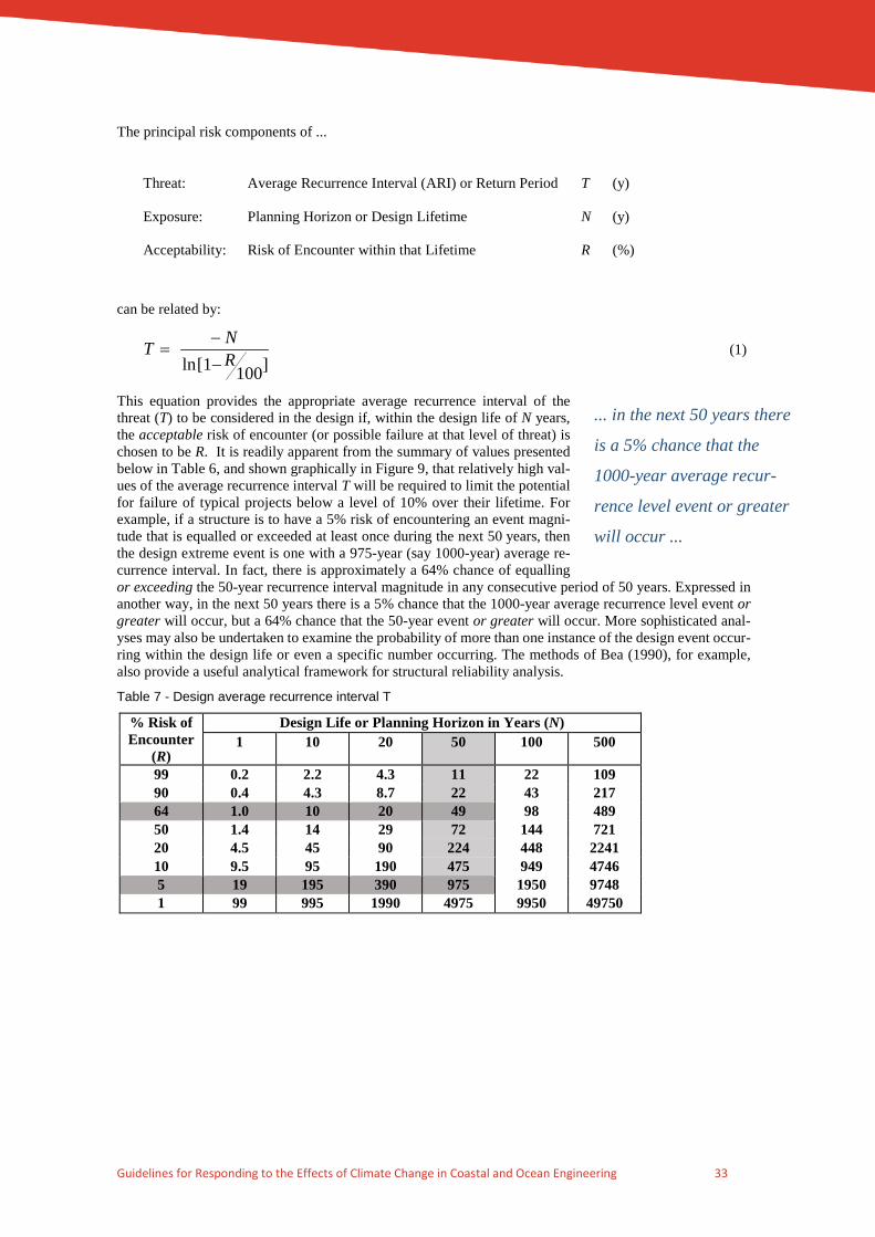
Guidelines for Responding to the Effects of Climate Change in Coastal and Ocean Engineering 33
The principal risk components of ...
Threat: Average Recurrence Interval (ARI) or Return Period T (y)
Exposure: Planning Horizon or Design Lifetime N (y)
Acceptability: Risk of Encounter within that Lifetime R (%)
can be related by:
]1001[ln RNT
−−
= (1)
This equation provides the appropriate average recurrence interval of the threat (T) to be considered in the design if, within the design life of N years, the acceptable risk of encounter (or possible failure at that level of threat) is chosen to be R. It is readily apparent from the summary of values presented below in Table 6, and shown graphically in Figure 9, that relatively high val-ues of the average recurrence interval T will be required to limit the potential for failure of typical projects below a level of 10% over their lifetime. For example, if a structure is to have a 5% risk of encountering an event magni-tude that is equalled or exceeded at least once during the next 50 years, then the design extreme event is one with a 975-year (say 1000-year) average re-currence interval. In fact, there is approximately a 64% chance of equalling or exceeding the 50-year recurrence interval magnitude in any consecutive period of 50 years. Expressed in another way, in the next 50 years there is a 5% chance that the 1000-year average recurrence level event or greater will occur, but a 64% chance that the 50-year event or greater will occur. More sophisticated anal-yses may also be undertaken to examine the probability of more than one instance of the design event occur-ring within the design life or even a specific number occurring. The methods of Bea (1990), for example, also provide a useful analytical framework for structural reliability analysis.
Table 7 - Design average recurrence interval T
% Risk of Encounter
(R)
Design Life or Planning Horizon in Years (N) 1 10 20 50 100 500
99 0.2 2.2 4.3 11 22 109 90 0.4 4.3 8.7 22 43 217 64 1.0 10 20 49 98 489 50 1.4 14 29 72 144 721 20 4.5 45 90 224 448 2241 10 9.5 95 190 475 949 4746 5 19 195 390 975 1950 9748 1 99 995 1990 4975 9950 49750
... in the next 50 years there
is a 5% chance that the
1000-year average recur-
rence level event or greater
will occur ...

Guidelines for Responding to the Effects of Climate Change in Coastal and Ocean Engineering 34
Figure 9 - Relationship between encounter probability, design life and average recurrence interval
While this method and its assumption of statistical stationarity has significant utility in allowing a rational consideration of risks, the changing climate condition will act to partly invalidate these assumptions over time, especially when the rate of change of key variables increases. Accordingly, sensitivity testing is rec-ommended as described below.
Step 6: Undertake a Sensitivity Analysis
Establishment of a design interaction matrix should facilitate this process, based on the current best estimates of climate change scenarios presently available or where no estimates are available, on an appropriate test assumption. In practical terms this might involve adjusting the modal value of a statistical distribution within certain bounds (simulating a bias or magnitude shift) or alternatively a change to the "slope" of the distribu-tion (simulating a change in frequency of occurrence) or a combination of both effects. The degree of as-sumed change should reasonably relate to the published levels of possible climate change and consider "mean" and "upper" predictions. In many situations, rather than assuming a direct effect, it might be neces-sary to consider the "filtering" effects of a number of related processes, as for example embodied in Table 5. The statistical recombination of assumptions is preferred where possible to avoid unnecessary subjectivity at this stage of the assessment.
Appendix C provides a simple interaction matrix template that may assist in the preliminary assessment of climate change sensitivities to a particular design.
Step 7: Assess and Review Design Assumptions
Examine the outcome of the sensitivity analysis with respect to the implied consequences and assess the suitability of the final design.
Step 8: Adjust the Design if Necessary
Repeat assessment Steps 1 through 7 as appropriate to reassess design life, encounter probability or to in-crease robustness or adaptability to minimise future risk.
4.4 Example Assessments The following detailed example impact assessments are provided for illustration of the method. The first case is of a complex offshore structure (fixed or floating), so as to illustrate the major aspects of the assessment methodology for a specific "engineered" facility. A second detailed example is provided in the next section for a nearshore tourism development where there is a greater reliance on "planned" facilities. Finally, an example of a Greenfield coastal community is given.
0.01
0.10
1.00
10.00
100.00
1 10 100
Project Design Life or Planning Horizon (y)
Enc
ount
er P
roba
bilit
y (%
)
10 y
50 y100 y
200 y500 y
1000 y
20 y
2000 y
10000 y5000 y
Equivalent Average Recurrence Interval

Guidelines for Responding to the Effects of Climate Change in Coastal and Ocean Engineering 35
4.4.1 Detailed Example 1: Fixed or Floating Offshore Structures Design Life:
The typical application for such structures would be for oil or gas extraction and processing, although some may support transport or tourist facilities.
For oil and gas situations, the design life is likely to vary primarily as a function of the expected production life of the reservoir (5 to 20 years). Typically, however, advances in product recovery technology (directional drilling etc.) and subsequent field exploration have caused the original design lives of many offshore facilities to be exceeded. Often costly retrofits have then become necessary to accommodate the additional weight of expanded processing facilities or stiffening to extend the fatigue and corrosion resistance of the major struc-tural elements. Small reservoir situations with unmanned or subsea facilities may justify a design life of 10 years or less, depending on project economics. Larger developments would typically extend to 20 years and, where further project expansion is likely, up to 40 years or more.
Consequences of Failure:
For the majority of offshore situations, the consequences of failure both direct and indirect will be very high. Direct effects would involve possible loss of life, loss of production and income, reinstatement costs and contractual defaults and penalties. Indirect effects could be potential environmental damage (e.g. oil spill), compensation costs for clean-up, claims made for interruption in product supply and loss of employment or damage to regional economies.
Design Encounter Probability:
The discussion here is limited to considerations of environmental structural loading. Other design elements, such as risk of human error, mechanical breakdown, fire or explosion will significantly influence the overall design process for oil and gas processing facilities. The process, structural, geotechnical and ocean engineers should adopt consistent design encounter assumptions.
Where loss of life as a result of failure or major environmental impact is expected, a design event encounter probability range as low as 0.5% to 1% might be appropriate. This would require designing some crucial structural elements for environmental loadings with an average recurrence interval of between 2,000 and 10,000 years, depending on the chosen design life. Different encounter probabilities might be appropriate for other aspects of the design, e.g. loss of production might be tolerated at the 5% level or greater, depending on the cost and time to repair, contractual or labour issues etc.
Design Philosophy:
A robust design philosophy should be considered for offshore facilities. The design concepts of ultimate strength and reserve strength ratio would generally apply, as presented for example in Bea (1990).
Selection of Appropriate Design Criteria:
The necessary magnitude of the relevant criteria follows from the specification of design life and encounter probability, e.g. a 1% encounter in a 20-year life requires a 2,000-year average recurrence level magnitude. Where a single forcing element dictates the design, for example wind forcing, the design requirements might be satisfied by simply adopting the relevant (gust or mean) wind speed magnitude and direction (key variable K3) indicated by either data or, more likely, hindcast or simulated statistical analyses. However, for the normal offshore condition, extreme loadings do not occur in isolation but rather within complex storm events. The joint probability of environmental loading combinations will therefore often be an important considera-tion. In this case, the relative magnitude, phasing, dynamics and spatial variation over the structure of a number of environmental loadings (currents S2, winds S3, waves S4) becomes dominant. The structural response is then the sum total of these separate forcing functions combined often with dynamically variable resistance characteristics of the seabed (anchor attachment, pore pressures, pile skin friction etc.). The re-sulting statistical loading function(s) should then become the basis for the design rather than the separate independent incident (wind, wave or current) conditions.
Sensitivity Analysis of Climate Change Scenarios:
At this point an interaction matrix should be constructed to isolate those design elements most likely to be affected by climate change. A template is provided in Appendix C, which has been reduced here as Table 8 to include only those combinations relevant to the offshore example, using Table 6 for guidance.

Guidelines for Responding to the Effects of Climate Change in Coastal and Ocean Engineering 36
Assess and Review Design Assumptions:
From Table 7, the principal impacts are seen to be local sea level, possible increased storminess with changes to local wind and wave climates (e.g. Southern Ocean, east coast low, monsoon, tropical cyclone) and per-haps some less critical operational matters.
Of these, sea level changes of the magnitudes presently predicted can and should be readily allowed for in a new design and at a relatively small overall cost. For existing structures, increased sea level will most no-ticeably cause inconvenience at tidal landings but this can be easily remedied. More importantly, a rising sea level decreases the underdeck wave clearance of fixed structures and may thereby significantly impact the encounter probability of failure. Retrofitting to increase structural strength or raise deck levels may then be a necessary option to maintain the original design risk of failure.
Increased storminess is potentially much more complex than sea level changes and the design allowance may need to be varied depending on the situation. For example, a location presently near the edge of tropical cyclone influence may experience a significant change in risk if the extent of cyclone influence increases. For a location already in a tropical cyclone region, the relative impact may be minor. These interpretations should be referred to specialist coastal and ocean engineers with appropriate numerical and statistical mod-elling capability to provide recommended design allowances.
4.4.2 Detailed Example 2: Nearshore Tourism Development Design Life:
A typical design life of between 20 and 50 years might be adopted. This could depend upon the scale of the development, style of architecture, construction materials and overall economic plan. Given the harsh marine environment, maintenance costs might dictate a replacement cycle for some non-structural marine facilities and fittings of generally not more than 15 years, but this should not reduce the design capacity within the overall project design life.
Consequences of Failure:
This may have several dimensions. The first might relate to low probability storm-related damage to break-waters, marinas, beaches, nearshore accommodation and infrastructure. This could result in possible loss of life, generally short term environmental damage and loss of income. The second dimension could relate to ongoing or operational matters such as beach and small craft amenity, wind and wave exposure, nearshore waters and groundwater quality, loss of desirable vegetation cover, potable water and the like. The major consequences of "failure" will likely be economic loss but environmental degradation could also occur and in some circumstances (e.g. storm surge) significant loss of life is possible without adequate warning or evacuation options.
Design Encounter Probability:
If loss of life is possible, for example such as an isolated low lying island or causeway situations, then rela-tively low design encounter probabilities are again advisable (akin to the preceding offshore design example). Where access to higher ground and shelter is readily available and warnings of severe conditions are likely, a higher encounter risk might be acceptable. Parts of the facility might be designed for differing levels of risk whereby high capital cost or protecting infrastructure such as breakwaters, causeways, hotels, central offices (administration, catering, commercial) are exposed to relatively low levels of risk over the life of the project. Bungalow-style accommodation units from which patrons would be evacuated and where damage could be readily repaired might accept a moderate risk level. Non-hazardous stormwater overflow, roadways, sacrificial boardwalks, landings and other minor structures could accept an even higher risk, where the con-sequences are minimal and the reinstatement costs are low. The adopted encounter probability levels may also be subject to legislative control in some areas and practitioners are expected to acquaint themselves with relevant regulations. The coastal and ocean engineer should liaise closely with the architect, builder, civil, structural, mechanical and electrical design engineers to ensure that consistent risk philosophies are being adopted across the project development.
Design Philosophy:
For those aspects of the development essential to its ongoing operational viability and environmental health and safety, a robust design philosophy should be considered. This might affect the management of the beach amenity whereby adequate setback distances need to be specified to maintain a natural active beach buffer

Guidelines for Responding to the Effects of Climate Change in Coastal and Ocean Engineering 37
zone, restricted dune access and vegetation control. It might lead to the need for special design studies to optimise circulation within marinas, modelling of breakwater stability, checking groundwater characteristics etc.
For ancillary elements of the development a least regrets philosophy might be considered. This might apply to boat landings, boardwalks, stormwater outlets, navigation markers, dredged depths, bar stability etc. The expectation would be that any "failure" of these items would be unlikely to cause secondary damage.
Table 8 - Example interaction matrix for an offshore structure
Offshore Structure
Example
Assessment
Mean Sea
Level
K1
Ocean Currents &
Temperature K2
Wind
Climate
K3
Wave
Climate
K4
Rainfall / Runoff
K5
Air
Temperature K6
Local Sea Level S1
-design for in-creases over lifetime in re-gard to tide and wave clearance -potential for minor changes in barometric surge heights
- some minor changes to sea-sonal mean lev-els possible due to density changes
- some minor changes to seasonal mean levels possible
- no effect - no effect - minor effect
Local Cur-rents S2
- no effect - likely seasonal changes which might affect oper-ations - baroclinic cur-rents may change
- possible ma-jor effect through in-creased storm-iness
- minor effect - no effect - no effect
Local Winds S3
- no effect - minor effect - possible ma-jor effect through in-creased storm-iness
- no effect - no effect - minor effect
Local Waves S4
- minor effect - minor effect - indirect effect - possible ma-jor effect through in-creased storm-iness - possible changes in swell direction
- no effect - no effect
Effects on Structures S5
- allowance must be incor-porated
- minor effect - potentially major effect on loadings
- potentially major effect on loadings, fa-tigue
- no effect - minor operational or process changes
Sediment Transport S10
- no effect - minor effect - no effect - possible in-creased scour around foun-dations, pipe-lines
- no effect - no effect
Quality of Coastal Wa-ters S12
- no effect - possible changes in oil spill destinations and travel times
- possible changes in oil spill destina-tions and travel times
- minor mixing effects
- no effect - minor effect
Ecology S13 - no effect - minor effect - minor effect - minor effect - no effect - no effect
Selection of Appropriate Design Criteria:
The necessary magnitude of the relevant criteria follows from the specification of design life and encounter probability, e.g. a 5% encounter in a 50-year life requires a 1000-year average recurrence level magnitude design event. As in the example of the offshore structure, joint probability considerations will be important

Guidelines for Responding to the Effects of Climate Change in Coastal and Ocean Engineering 38
for the consideration of the occurrence of tropical cyclone storm surge, tide and wave setup on overland flooding, beach and breakwater stability. It can normally be assumed that wind and wave conditions will be closely correlated, i.e. those encountered conditions will have essentially the same average recurrence inter-vals. Specialist advice may be necessary on such matters if the development is found to be sensitive to the assumptions made during design.
Sensitivity Analysis of Climate Change Scenarios:
The interaction matrix in Table 9, highlights the likely major areas that should be examined for their sensi-tivity to the adopted design.
Assess and Review Design Assumptions:
The interaction matrix highlights sea level increases (K1), wind (K3) and wave (K4) climate changes as being the major concerns. These have impacts across a wide range of the process variables and the design philosophy would need to ensure that potential changes would have minimal effect on the development. This might require conservatism in critical design components such as breakwater design, harbour entrance, major buildings and setbacks etc.
4.4.3 Detailed Example 3: Greenfield Coastal Community
Design Life:
The design life of an entire community, comprising housing, commercial, industrial and infrastructure ser-vices may well be regarded as between 50 and 100 years. While commercial replacement might occur as frequently as 10 to 20 years, domestic housing of high quality may survive several generations before re-placement, and be renovated periodically. Infrastructure is normally expected to function for at least 50 years and be gradually augmented, unless directly exposed to a harsh marine environment. In that case maintenance costs might dictate a replacement cycle for non-structural marine facilities and fittings of generally not more than 15 years.
The key element is the permitted change in land use. Current planning frameworks make downgrading of land use extremely difficult. A decision to change land use (e.g. from rural to residential) has no design horizon and that use (or its expectation) then continues in perpetuity. One further aspect of such a community that complicates adaptation responses is that the land comprising the development is likely to be in the own-ership of hundreds or even thousands of individuals. Coordinating replacement of housing and infrastructure in a strategic manner is likely to be very difficult in these circumstances with few, if any, demonstrated cases, leading to ad hoc, piecemeal responses to the range of hazards likely to have an impact on the community. Thus it might lead to longer term benefits if a higher priority is given to prevention of exposure to the hazards as the primary response, over expectations of future adaptation in such situations.
Consequences of Failure:
If there is direct marine exposure to some elements of the development then Example 2 effects will apply to those areas, such as low probability storm-related damage to breakwaters, marinas, beaches, nearshore facil-ities and exposed infrastructure. This could result in possible loss of life, generally short term environmental damage and loss of income. Further direct exposure might be through tidal creeks, drains and wetlands providing pathways for permanent inundation or increased frequency of flooding, either from the sea or as a result of increasing tailwater levels during terrestrial/fluvial flood events.
For all non-direct exposure, the intention should be to limit development so as to avoid hazard exposure or limit failure within the design life. For this purpose, planning zones with differing design lives might be appropriate, anticipating adoption of a “planned retreat” predicated on identified hazard triggers, such as erosion incursion or a predetermined hazard level (say 50-y ARI etc). Subject to legal frameworks and agree-ments, affected lands could be either converted to open space or re-developed under additional conditions. It is noted that no examples of effective planned retreat of any significant urban areas exist throughout Aus-tralia and relevant international examples involve only restoration of marshlands from rural areas such as in the United Kingdom. It is not possible in these guidelines to assess the practical risks and community costs associated with retreat or abandonment of large numbers of titles under individual ownership.

Guidelines for Responding to the Effects of Climate Change in Coastal and Ocean Engineering 39
Table 9 - Example interaction matrix for a nearshore tourism development
Nearshore Tourism
Development Example
Assessment
Mean Sea
Level
K1
Ocean Currents &
Temperature K2
Wind
Climate
K3
Wave
Climate
K4
Rainfall / Runoff
K5
Air
Temperature K6
Local Sea Level S1
- major ef-fect in estu-aries and tidal lakes - greater risk of storm surge inun-dation
- possible minor changes in sea-sonal variability of water level
- possible mi-nor changes in seasonal vari-ability of water level
- wave setup could increase
- possible flood inter-action
- minor effect
Local Currents S2
- major di-rect effect in estuaries and tidal lakes
- possible changes to pre-vailing currents
- major direct effect
- possible ma-jor effect for barred en-trances
- possible flood inter-action
- no effect
Local Winds S3
- no effect - minor effect - major direct effect
- no effect - no effect - minor sea breeze effects
Local Waves S4
- major ef-fect in shal-low water re-gions
- minor effect - indirect effect - major direct effect
- minor ef-fect
- no effect
Effects on Structures S5
- major di-rect effect
- minor effect - major direct effect
- major direct effect
- major ef-fect de-pending on location or purpose
- no effect
Groundwater S6
- major di-rect effect on quality and storage
- no effect - no effect - local setup may cause dy-namic effects
- may af-fect phre-atic surface
- minor effect
Coastal Flood-ing S7
- major di-rect effect on expo-sure, drain-age, runoff
- no effect - major direct effect via in-tensity and fre-quency of se-vere storms and cyclones
- major direct effect via wave setup at open sites
- direct ef-fect via changes in rainfall dis-tribution, intensity and fre-quency
- no effect
Beach Response S8
- major ef-fect of re-cession with sea level rise - realign-ment
- minor effect - possible changes to ae-olian transport processes
- major effects of wave direc-tional energy changes
- possible effects of estuary discharges
- possible vegeta-tion changes; sea breeze effects
Foreshore Sta-bility S9
- major changes to wave pene-tration possi-ble -groundwa-ter levels - sediments exposed to erosion
- minor effect - dune shape and vegetation
- major direct effects on scarp toe ero-sion - runup and overtopping - breakthrough
- elevated phreatic levels; pore pressure changes; vegetation
- vegetation changes; weather-ing
Sediment Transport S10
- changed distribution of motive energy;
- may affect sedi-ment supply
- longshore wind gener-ated currents
- wave direc-tional energy changes; mag-
- may af-fect sources/sin
- sea breeze ef-fects; vegetation

Guidelines for Responding to the Effects of Climate Change in Coastal and Ocean Engineering 40
Nearshore Tourism
Development Example
Assessment
Mean Sea
Level
K1
Ocean Currents &
Temperature K2
Wind
Climate
K3
Wave
Climate
K4
Rainfall / Runoff
K5
Air
Temperature K6
breaker depth; wave refracted an-gle
- effect on dune mobility and direction
nitude and du-ration of storms
ks of littoral drift
Hydraulics of Estuaries S11
- major im-pact on tidal prism, sea-water intru-sion
- minor effect - influence on circulation in shallow waters
- effect on inlet characteristics, mixing
- major changes could influ-ence tidal circulation, density
- no effect
Quality of Coastal Waters S12
- major ef-fect on ex-change rates in es-tuaries
- minor effect - possible changes in mixing and tur-bidity
- possible changes in mixing and tur-bidity
- possible changes in salinity, stratifica-tion, turbid-ity
- minor effect
Ecology S13
- major changes in zonation
- possible nutri-ent changes
- possible changes in mixing and tur-bidity
- major changes in zo-nation
- localised salinity changes
- possible effects coral reefs and foreshore vegeta-tion
Design Encounter Probability:
Where loss of life is possible, for example such as isolated low lying land or causeway situations, then rela-tively low design encounter probabilities are advisable. Where access (evacuation routes) to higher ground and shelter is readily available and warnings of severe conditions are likely, a higher encounter risk might be acceptable. Parts of the community might be designed for differing levels of risk whereby high capital cost or protecting infrastructure such as breakwaters, groynes, seawalls, causeways, bridges are exposed to relatively low levels of risk over the life of the community.
Commercial and industrial developments can often be preferentially located in predominantly flat areas with a higher risk (but still acceptable) of flooding, whereby car parks and undercrofts can be used as floodways or flood storage, but floor levels are suspended to meet a low operational risk level.
Public space should be utilised and set aside for temporary flood conveyance at moderate levels of risk. Non-hazardous stormwater overflow, roadways, sacrificial boardwalks, landings and other minor structures could also accept a moderate risk where the consequences are minimal and the reinstatement costs are low.
Public housing and public buildings should never be sited where exposed to ocean impacts, whether via direct surge, tide, setup and runup events or erosion encroachment. Low velocity flooding could be tolerated with moderate risk if floor levels are suspended to meet a very low level of risk.
Emergency infrastructure (police, ambulance, hospital, fire and rescue, control and command, communica-tion hubs, shelters, aged care facilities, schools etc.) must be located in areas with very low risk of impact and with appropriate storm-accessible transport corridors.
The adopted encounter probability levels and relevant climate change parameters to be used may also be subject to legislative control in some areas and practitioners are expected to acquaint themselves with rele-vant regulations. The coastal and ocean engineer should liaise closely with the architect, builder, civil, struc-tural, mechanical and electrical design engineers to ensure that consistent risk philosophies are being adopted across the project development.
Design Philosophy:
For those aspects of the community essential to its economic viability and environmental health and safety, a robust design philosophy should be considered, supported by detailed investigation and design (breakwa-ters, bridges, floodways, groundwater). Sea level rise issues should be addressed through planning to main-tain a natural active beach buffer zone over the design life, suitably elevated building sites and/or ensure adequate freeboard for low velocity flooding events. Alienation of some coastal lands may be an option in

Guidelines for Responding to the Effects of Climate Change in Coastal and Ocean Engineering 41
specific situations for environmental and/or hazard considerations. Fortification of residential or commercial premises as a long term planning strategy should be avoided.
Underground carparks that are at a finite risk of flooding should be subject to closure and inspection proce-dures and include safe emergency egress.
For ancillary elements of the community a least regrets philosophy might be considered. This might apply to minor recreational or sporting structures, boat landings, boardwalks, stormwater outlets, etc. The expec-tation would be that any "failure" of these items would be unlikely to cause secondary damage or dangers.
Selection of Appropriate Design Criteria:
The necessary magnitude of the relevant criteria follows from the specification of design life and encounter probability, e.g. a 5% encounter in a 50-year life requires a 1000-year average recurrence level magnitude design event. As with the other examples, joint probability considerations may be important for the consid-eration of the occurrence of storm surge, tide and wave setup on overland flooding, beach and breakwater stability.
It can normally be assumed that wind and wave conditions will be closely correlated, i.e. those encountered conditions will have essentially the same average recurrence intervals. Riverine flooding in situations of short stream concentration times may also require allowance for raised surge-affected tailwater levels. Spe-cialist advice may be necessary on such matters if the development is found to be sensitive to the assumptions made during design.
Sensitivity Analysis of Climate Change Scenarios:
The interaction matrix in Table 9 is deemed equally applicable to this example and highlights the likely major areas that should be examined for their sensitivity to the adopted design.
Assess and Review Design Assumptions:
The interaction matrix highlights sea level increases (K1), wind (K3) and wave (K4) climate changes as being the major concerns. These have impacts across a wide range of the secondary variables and the design philosophy would need to ensure that potential changes would have minimal effect on the community. For Greenfield sites, sensitivity analyses concentrating on upper-bound estimates for climate change should be carefully considered.
4.5 Summary The interaction matrix method is recommended here as an objective approach for considering the possible impacts of climate change in coastal and ocean engineering practice. Ideally, such an assessment should be a group process involving not just the relevant technical personnel but a broad group of interests and stake-holders. In 1991, this technique was developed from a series of workshops hosted by the NCCOE that in-volved a collective assessment from more than 20 practising coastal and ocean engineers, who worked through a range of typical projects (refer Appendix A). Practitioners are therefore urged to incorporate peer review into their quality assurance procedures wherever possible to ensure a critical and objective consider-ation of the possible impacts of climate change.

Guidelines for Responding to the Effects of Climate Change in Coastal and Ocean Engineering 42
5. RESEARCH AND MONITORING NEEDS
5.1 The Scientific Basis The following is presented as a commentary on the present status of research and monitoring needs for in-creasing the understanding of potential climate change and its impacts on the coastal and ocean environment.
An extensive research effort is directed towards projecting the degree and timing of possible climate change. This primarily centres on the complex numerical modelling of the climate on a global scale, where the Earth itself becomes the control volume. This facilitates the use of aggregated data from a number of sites around the world, an averaging of trends to provide a reference point and then the calibration of models against the observed historical changes. Numerical model physics continues to be developed, with the representation of ocean-atmosphere and carbon-cycle coupling becoming more sophisti-cated. Modelling at smaller scales is considered to be less reliable be-cause it stretches the validity of the numerical model assumptions, forces consideration of finer sub-resolution scale interactions and suffers from a lack of data at the regional scale.
All of the above research is directed towards more reliable predictions of the state of future climate. It takes place within essentially a competi-tive academic framework and is funded primarily by Government. Con-tinuing work that focuses on demonstrating improved modelling accu-racy with clear regional application is to be encouraged and supported.
5.2 Impacts, Adaptation and Vulnerability to Climate Change Quantifying the subsequent impacts of possible climate change and the environmental adaptations that might occur are much more complex than determining the overall state of climate from a global control volume perspective. This is primarily related to the already limited state of knowledge of the many complex inter-acting temporal and spatial scales of oceanic, terrestrial and atmospheric processes. Each of these elements is already subject to extensive but specific numerical modelling efforts in the quest to understand present system behaviour. To argue that such models of present system behaviour would perform with the same skill level when addressing climate change remains a moot point. While climate change research in these areas is still essential, a focus on understanding observed processes is imperative in the short term, avoiding the temptation of making premature or weakly founded predictions that may simply serve to add to the confusion of knowledge.
The possible biological impacts and adaptations to the changing physical environment remain an essential consideration. While many studies exist that are scenario driven, more baseline experimentation and study appears highly desirable.
Societal adaptation and mitigation strategies ultimately will need to operate at the regional and local scale. It is therefore much more difficult to treat this aspect of the problem in an objective scientific or mathematical way. While some of the more obvious climate impacts and possible solutions have already been extensively canvassed, it is likely that more subtle changes may ultimately cause the most severe impacts in certain regions. The relative importance of potential sea level rise versus changing wave energy flux is a case in point. These aspects can be addressed by an intelligent planning regimen but need to be supported by scien-tifically based hazard assessments to provide the parameters and limits for planning. Much exists in the literature on the planning process and a further decade of discussion will likely add little to this knowledge. Action is needed to establish the legislative frameworks and to provide the essential scientific parameters for the planning authorities such as safe setbacks, sea level limits, bunded zones, infrastructure replacement and aquifer management plans etc. Effective legislative action requires strong political will, while the identifica-tion of the threats and treatment options requires the harnessing of appropriate engineering and related sci-entific expertise and provision of research and investigation funding.
Continuing work that focuses on
demonstrating improved model-
ling accuracy with clear re-
gional application is to be en-
couraged and supported.

Guidelines for Responding to the Effects of Climate Change in Coastal and Ocean Engineering 43
5.3 Coastal and Ocean Engineering Issues Engineering, whether by investigation or actual works, is a major vehicle for physical intervention in the coastal/ocean zone. Coastal and ocean engineering investigation and research are most vital, yet to-date, are essentially a non-funded component of the response to climate change in Australia. The engineering per-spective is clearly essential for addressing the feasibility of adopting specific mitigation options and the subsequent selection of practical planning parameters. Engineering assessment requires upstream inputs from the atmospheric and oceanographic sciences but then applies that knowledge to the risk assessment of those climate impacts on the natural (to keep it that way) and the built (to maintain it) coastal and ocean environ-ment.
Climate change is but one of many pertinent issues that have been previously identified by the NCCOE (NCCOE 1991, 1993, 1995, 2004a,b) as requiring a concerted engineering research effort and which need to be underpinned by long-term strategic data collection programs.
The numerical prediction of potential coastal and ocean zone impacts will remain unverified and of limited practical application without significant (i.e. 50 or more years) accumulated high resolution regional data on:
• sea level variation
• shoreline changes
• estuary dynamics
• aquifer responses
• nearshore and offshore wind, wave and current characteristics
• sediment transport mechanisms
• estuarine and coastal water quality.
The following are therefore seen as the more significant issues affecting progress on climate change impacts of relevance to coastal and ocean engineering issues:
A lack of relevant coastal and ocean data sets
While some long term wind (e.g. Bureau of Meteorology; 70 year) and wave datasets (e.g. NSW and Qld governments; 40 year) exist and are of immense value, much collected data around Australia is sparse, in-complete, random and unintegrated. Urgent action is required to establish or expand engineering-related coastal and ocean data collection programs across Australia. To achieve this, the increasing trend of reduction in funding for public engineering and infrastructure projects, and the loss of Government engineering exper-tise in decision making, must be reversed. Monies may need to be allocated for the acquisition of long term physical data sets that can be used for verified studies in the future.
Verifiable regional climate predictions
This requires the continuation of ongoing core research by climate specialists (atmospheric scientists, mete-orologists and oceanographers) leading to model development and sensitivity testing against historical data sets. Verification of climate trends, however, will necessarily await the accumu-lation of relevant reliable data.
Engineering-based impacts and adaptation research
NCCOE (2004) had estimated that less than 10% of Australia’s climate change research budget was directed at coastal and ocean related issues and impacts, with most of that amount allocated to sea level monitoring alone. Of this, only a very small fraction was being undertaken by engineering research organisations. Recent data10 suggests that total Commonwealth Government expenditure on cli-mate adaptation-related activities fell from around 7% in 2008-09 to about 1.5%
10 http://www.aph.gov.au/About_Parliament/Parliamentary_Departments/Parliamentary_Library/pubs/rp/BudgetReview201314/ClimateChange
Without significant accumulated
data ... numerical prediction of
potential coastal and ocean
zone impacts will remain unver-
ified and of limited practical ap-
plication.
less than 7% of Aus-
tralia’s climate change
research budget appears
directed at coastal and
ocean related issues and
impacts …

Guidelines for Responding to the Effects of Climate Change in Coastal and Ocean Engineering 44
by 2013-14. An examination of Australian Research Grants11 over the period 2001 to 2016 shows that only around 6.5% of the $910M of allocated grants with “climate” as a keyword also included “coast” or “engi-neering”. Concerted efforts need to be made by Engineers Australia and individual engineering research organisations to gain greater access to the available pool of research funds and to influence the priorities for allocation of funds. A requirement for ARC grant applicants to include a professional engineering sponsor might be a way of ensuring that more targeted and practically relevant climate adaptation research will be undertaken.
NCCOE (1995), for example, recommended a national program be undertaken to assess the coastal impacts of climate change using a quantitative risk management approach that could form the basis of long term planning and management strategies. This was expected to be a major undertaking conducted over many years and taking some time to plan and develop the appropriate methodology. Much of the necessary exper-tise, numerical tools and actual experience for undertaking such studies already exists within the coastal and ocean engineering fraternity in Australia. These studies would ideally be multi-disciplinary, calling on addi-tional advice from scientists (earth, ocean, climate, biological) and coastal planners and managers (environ-ment, tourism, recreation, transport, ports) as required. With Commonwealth support NCCOE (2012c) "Cli-mate Change adaptation guidelines in coastal management and planning" was produced in the spirit of this recommendation as a base reference document. The emergence of the Commonwealth-funded NCCARF capacity-building initiative has been an acknowledged step forward in principal.
Coastal Adaptation Funding
In recent years, additional national funding for natural hazards risk assessment and adaptation at the Local Government level became available through the Commonwealth Government, often administered by and with contributions, from State governments. Some jurisdictions have undertaken significant data collection and complex risk assessment projects, but without the benefit of nationally consistent methodologies and standards. This highlights that there has been no framework put in place to ensure the effectiveness and consistency of the studies and most of these initiatives represent a very minor investment compared with what is needed to underpin the long-term planning and sustainability of coastal communities. The quantum of funding typically being allocated to or by individual coastal communities continues to be a small fraction of the median market price of a single dwelling in any of the affected areas. This limits the accuracy, com-prehensiveness and detail of such studies to a level far short of what is possible with current knowledge and tools and far short of what is required for long-term sustainable development or adaptation.
6. GLOSSARY
ACCARNSI Australian Climate Change Adaptation Research Network for Settlements and Infrastructure
AOGCM Atmosphere-Ocean Global Climate Model
ARC Australian Research Council grants
ARI Average Recurrence Interval or Return Period
AR4 IPCC Assessment Report 4
AR5 IPCC Assessment Report 5
BoM Bureau of Meteorology
CAWCR Centre for Australian Weather and Climate Research (BoM/CSIRO)
CFC Chlorofluorocarbons (refrigerant gases)
CSIRO Commonwealth Scientific and Industrial Research Organisation
EA Engineers Australia
ENSO El Niño - Southern Oscillation
ESM Earth Simulation Model
HCFC Hydrochlorofluorocarbons (refrigerant gases)
11 https://rms.arc.gov.au/RMS/Report/Download/Report/d6b15b2b-3a50-4021-8e6f-6c7ef1cba553/0#

Guidelines for Responding to the Effects of Climate Change in Coastal and Ocean Engineering 45
ICZM Integrated Coastal Zone Management
IOD Indian Ocean Dipole
IPCC Intergovernmental Panel on Climate Change, WMO
MPI Maximum Potential Intensity of tropical cyclones
NCCARF National Climate Change Adaptation Research Facility
NCCOE National Committee on Coastal and Ocean Engineering, Engineers Australia
NTU National Tidal Unit, Bureau of Meteorology
RCP Representative Concentration Pathways
RF Radiative Forcing
SAM Southern Annular Mode
SLR Sea Level Rise
SOI Southern Oscillation Index
SRES Special Report on Emission Scenarios
SST Sea Surface Temperature
STR Sub-tropical Ridge
UNEP United Nations Environment Programme
UNFCC United Nations Framework Convention on Climate Change
UVB Ultra-Violet B solar radiation.
WMO World Meteorological Organization (part of the United Nations)

Guidelines for Responding to the Effects of Climate Change in Coastal and Ocean Engineering 46
7. REFERENCES
Abuodha P. and Woodroffe C.D., 2007: Assessing vulnerability of coasts to climate change: A review of approaches and their application to the Australian coast, In Woodroffe CD, Bruce, E, Puotinen, M and Furness RA (Eds), GIS for the Coastal Zone: A selection of Papers from CoastGIS 2006, Aus-tralian National Centre for Ocean Resources and Security, University of Wollongong, 458p
AGO, 2006: Assessing and mapping Australia’s coastal vulnerability to climate change: expert technical workshop. Australian Greenhouse Office, Australian Government, 31pp,
Allen Consulting, 2005: Climate change risk and vulnerability: promoting an efficient adaptation response in Australia. Australian Greenhouse Office, Mar, 2005, 159pp.
Alexander L., Wang X., Wan H. and Trewin B. 2011: Significant decline in storminess over southeast Aus-tralia since the late 19th century. Australian Meteorological and Oceanographic Journal, 61, 23-30.
Attwater C., Carley J. and Witte E., 2008: Establishing triggers for adaptive response to climate change. Proc. IPWEA Conference on Climate Change Response, Coffs Harbour, Aug.
Bea R.G., 1990: Reliability based design criteria for coastal and ocean structures. National Committee on Coastal and Ocean Engineering, The Institution of Engineers Australia, ISBN 085825-518-9, 220pp.
BoM, 2016: Annual climate summary report 2015. Bureau of Meteorology. Available online at http://www.bom.gov.au/climate/annual_sum/2015/.
Borgman L. 1963: Risk Criteria. Journal of the Waterway, Port, Coastal and Ocean Division, ASCE, Vol 89, No. WW3, Aug, 1 - 35.
Bruun P., 1962: Sea-level rise as a cause of shore erosion. Journal of Waterways and Harbors Division, ASCE, 88, 117–130.
Callaghan D., Ranasinghe R. and Short A., 2008a: Quantifying the storm erosion hazard for coastal planning, Coastal Engineering, Vol. 56, 90-93.
Callaghan D., Nielsen P., Short A. and Ranasinghe R. 2008b: Statistical simulation of wave climate and extreme beach erosion, Coastal Engineering, Vol 55(5), 375-390.
Callaghan, J. and Power S.B., 2011: Variability and decline in the number of severe tropical cyclones making land-fall over eastern Australia since the late nineteenth century. Clim. Dyn., 37, 647–662.
Church J.A., Hunter J.R., McInnes K. and White N.J., 2006: Sea-level rise around the Australian coastline and the changing frequency of extreme events. Australian Meteorological Magazine, 55: 253-260.
Church J.A. and White N.J., 2011: Sea-Level Rise from the Late 19th to the Early 21st Century. Surveys in Geophysics, 32, 4-5, pp. 585-602,
CSIRO, 2015: Climate change in Australia - information for Australia’s natural resource management re-gions: Technical Report, CSIRO and Bureau of Meteorology, Australia, 222pp.
DCC, 2009a: Climate change adaptation actions for local government. Prep by SMEC Australia, Common-wealth of Australia, Department of Climate Change, 71pp.
DCC, 2009b: Climate change risks to Australia’s coast – a first pass national assessment. Commonwealth of Australia, Department of Climate Change, 172pp.
Dube S.K, Murty T.S., Feyen J.C., Cabrera R., Harper B.A., Bales J.D. and Amer S. 2010: Storm surge modeling and applications in coastal areas. In Chan J. (Ed.) Global Perspectives on Tropical Cyclones, World Scientific, April, 448pp.
Gourlay M.R., 1997: Wave setup on coral reefs: some practical applications. Pacific Coasts and Ports ’97. (13th Australasian Conference on Coastal and Ocean Engineering and 6th Australasian Port and Har-bour Conference), Centre for Advanced Engineering, Christchurch, 959-964.

Guidelines for Responding to the Effects of Climate Change in Coastal and Ocean Engineering 47
Haigh I.D., MacPherson L.R., Mason M.S., Wijeratne E.M.S., Pattiaratchi C.B., Crompton R.P. and George S., 2013: Estimating present day extreme water level exceedance probabilities around the coastline of Australia: tropical cyclone-induced storm surges. Climate Dynamics, DOI 10.1007/s00382-012-1653-0.
Haigh I.D., Wijeratne E.M.S., MacPherson L.R., Mason M.S., Pattiaratchi C.B., Crompton R.P. and George S., 2014: Estimating present day extreme water level exceedance probabilities around the coastline of Australia: tides, extra-tropical storm surges and mean sea level. Climate Dynamics, 42, 121-138.
Hallegatte, S. (2009), Strategies to adapt to an uncertain climate change, Global Environmental Change (19), 240-247.
Harper B.A., 1999: Storm tide threat in Queensland: history, prediction and relative risk. Dept. of Environ-ment and Heritage. State of Queensland, Conservation technical report No. 10, RE208-2, Jan, ISSN 1037-4701, 23pp.
Harper B.A., (Ed.), 2001: Queensland climate change and community vulnerability to tropical cyclones - ocean hazards assessment - Stage 1, Report prep by Systems Engineering Australia Pty Ltd in asso-ciation with James Cook University Marine Modelling Unit, Queensland Government, March, 375pp.
Harper B.A., 2004: Queensland climate change and community vulnerability to tropical cyclones – ocean hazards assessment: synthesis report, Queensland Government, Aug, 38pp.
Harper B., 2008: Managing sea level rise and climate change, Proc. IPWEA Conference on Climate Change Response, Coffs Harbour, Aug.
Harper B., Hardy T., Mason L. and Fryar R., 2009: Developments in storm tide modelling and risk assess-ment in the Australian region. Proc. WMO/IOC JCOMM 1st Scientific and Technical Symposium on Storm Surges, Seoul, Korea, 2-6 Oct, 2007, Natural Hazards, Vol 51, 1, Oct, 225-238.
Harper B., Stroud S., McCormack M. and West S., 2008: A review of historical tropical cyclone intensity in north-western Australia and implications for climate change trend analysis. Aust. Met. Mag., Vol. 57, No. 2, June, 121-141.
Harper B., Smith M., Erhart D., Anderson G. and Sultmann S., 2013a: A coastal hazard adaptation study for Townsville: pilot study. Proc. Coasts and Ports Conf, Engineers Australia, Sydney, Sept.
Harper B., Smith M., Mason, L., Schwartz R. and Acworth C., 2013b: Gulf of Carpentaria storm tide and inundation study. Proc. Coasts and Ports Conf, Engineers Australia, Sydney, Sept.
Harris P.T., Heap A.D., Bryce S.M., Porter-Smith R., Ryan D.A. and Heggie D.T., 2002: Classification of Australian clastic coastal depositional environments based upon a quantitative analysis of wave, tidal, and river power. Journal of Sedimentary Research, Vol. 72, No. 6, Nov, 858–870.
Harvey N. and Woodroffe C.D., 2008: Australian approaches to coastal vulnerability assessment. Sustain Sci., 3, 67–87.
Heap A., Bryce S., Ryan D., Radke L., Smith C., Smith R., Harris P. & Heggie D., 2001: Australian Estuaries & Coastal Waterways: A Geoscience Perspective for Improved and Integrated Resource Manage-ment. A Report to the National Land & Water Resources Audit; Theme 7: Ecosystem Health. AGSO Geoscience Australia, AGSO Record 2001/07, Mar, 125pp.
Hemer M.A., McInnes K., Church J.A., O’Grady J. and Hunter J.R., 2008: Variability and trends in the Australian wave climate and consequent coastal vulnerability. CSIRO, 138pp.
Hemer M.A., McInnes K., Ranasinghe, R., 2009: Future projections of the East Australian wave climate. Proceedings of the 11th International Workshop on wave hindcasting and forecasting and coastal haz-ards, Halifax, Canada (in press).
Hoegh-Guldberg, O., 2005: Low coral cover in a high-CO2 world. J. Geophys. Res. C, 110, C09S06, doi,10.1029/2004JC002528.
Hunter J.R., 2009: Estimating sea-level extremes under conditions of uncertain sea-level rise, Climatic Change, DOI: 10.1007/s10584-009-9761-6.

Guidelines for Responding to the Effects of Climate Change in Coastal and Ocean Engineering 48
IPCC, 1996: Climate change 1995 - the science of climate change. Contribution of Working Group I to the Second Assessment Report of the Intergovernmental Panel on Climate Change, Cambridge Univer-sity Press, ISBN 0 521 56436 0, 572pp.
IPCC, 2012: Managing the Risks of Extreme Events and Disasters to Advance Climate Change Adaptation. A Special Report of Working Groups I and II of the Intergovernmental Panel on Climate Change [Field, C.B., V. Barros, T.F. Stocker, D. Qin, D.J. Dokken, K.L. Ebi, M.D. Mastrandrea, K.J. Mach, G.-K. Plattner, S.K. Allen, M. Tignor, and P.M. Midgley (eds.)]. Cambridge University Press, Cam-bridge, UK, and New York, NY, USA, 582 pp.
IPCC, 2013: Climate Change 2013: The Physical Science Basis. Contribution of Working Group I to the Fifth Assessment Report of the Intergovernmental Panel on Climate Change [Stocker, T.F., D. Qin, G.-K. Plattner, M. Tignor, S.K. Allen, J. Boschung, A. Nauels, Y. Xia, V. Bex and P.M. Midgley (eds.)]. Cambridge University Press, Cambridge, United Kingdom and New York, NY, USA, 1535 pp.
IPCC, 2014a: Climate Change 2014: Impacts, Adaptation, and Vulnerability. Part A: Global and Sectoral Aspects. Contribution of Working Group II to the Fifth Assessment Report of the Intergovernmental Panel on Climate Change [Field, C.B., V.R. Barros, D.J. Dokken, K.J. Mach, M.D. Mastrandrea, T.E. Bilir, M. Chatterjee, K.L. Ebi, Y.O. Estrada, R.C. Genova, B. Girma, E.S. Kissel, A.N. Levy, S. Mac-Cracken, P.R. Mastrandrea, and L.L. White (eds.)]. Cambridge University Press, Cambridge, United Kingdom and New York, NY, USA, 1132 pp.
IPCC, 2014b: Climate Change 2014: Impacts, Adaptation, and Vulnerability. Part B: Regional Aspects. Con-tribution of Working Group II to the Fifth Assessment Report of the Intergovernmental Panel on Climate Change [Barros, V.R., C.B. Field, D.J. Dokken, M.D. Mastrandrea, K.J. Mach, T.E. Bilir, M. Chatterjee, K.L. Ebi, Y.O. Estrada, R.C. Genova, B. Girma, E.S. Kissel, A.N. Levy, S. MacCracken, P.R. Mastrandrea, and L.L. White (eds.)]. Cambridge University Press, Cambridge, United Kingdom and New York, NY, USA, 688 pp.
IPCC, 2014c: Climate Change 2014: Synthesis Report. Contribution of Working Groups I, II and III to the Fifth Assessment Report of the Intergovernmental Panel on Climate Change [Core Writing Team, R.K. Pachauri and L.A. Meyer (eds.)]. IPCC, Geneva, Switzerland, 151 pp.
Knutson T.R., McBride J.L., Chan J., Emanuel K., Holland G., Landsea C., Held I., Kossin J.P., Srivastava A.K. and Sugi M., 2010: Tropical cyclones and climate change. Nature Geoscience, 3, 15 –163.
McInnes, K.L., Walsh K.J.E., Hubbert G.D. and Beer T., 2003: Impact of sea-level rise and storm surges on a coastal community. Nat. Hazards, 30, 187-207.
McInnes K., Macadam I., Abbs D., O’Farrell S.P., O’Grady J., and Ranasinghe R., 2007: Projected changes in climatological forcing conditions for coastal erosion in NSW. Tech Report, CSIRO, Melbourne, Australia, 38pp.
McInnes K.L., White C.J., Haigh I.D., Mark A. Hemer M.A., Hoeke R.K., Holbrook N.J., Kiem A.S., Oliver E.C.J., Ranasinghe R., Walsh K.J.E., Westra S. and Cox R., 2016: Natural hazards in Australia: sea level and coastal extremes. Climatic Change, doi:10.1007/s10584-016-1647-8.
Meyers G., McIntosh P., Pigot L. and Pook M., 2007: The years of El Niño, La Niña, and interactions with the tropical Indian ocean. Journal of Climate, 20, 2872-2880.
Mills G.A., Webb R., Davidson N. E., Kepert J., Seed A. and Abbs D., 2010: The Pasha Bulker east coast low of 8 June 2007. Centre for Australian Weather and Climate Research, Australia, CAWCR Tech-nical Report 23.
NCCOE, 1991: Guidelines for responding to the effects of climatic change in coastal engineering design. National Committee on Coastal and Ocean Engineering, The Institution of Engineers, Australia, ISBN 85825 564 2, 50pp.
NCCOE, 1993: At what price data? National Committee on Coastal and Ocean Engineering, The Institution of Engineers, Australia, ISBN 85825-596-0, November, 28pp.
NCCOE, 1995: Coastal zone management research needs. Outcomes arising from a priority setting workshop on coastal zone management research needs held in Sydney 11-12th October 1994, funded by the

Guidelines for Responding to the Effects of Climate Change in Coastal and Ocean Engineering 49
Department of Environment, Sport and Territories. National Committee on Coastal and Ocean Engi-neering, The Institution of Engineers, Australia, February, 50pp.
NCCOE, 2004a: Guidelines for responding to the effects of climate change in coastal and ocean engineering. National Committee on Coastal and Ocean Engineering, Engineers Australia, 65pp.
NCCOE, 2004b: Coastal engineering guidelines for working with the Australian coast in an ecologically sustainable way. National Committee on Coastal and Ocean Engineering, Engineers Australia.
NCCOE, 2012a: Guidelines for responding to the effects of climate change in coastal and ocean engineer-ing. National Committee on Coastal and Ocean Engineering, Engineers Australia, 3rd ed., June, 74pp.
NCCOE, 2012b: Coastal engineering guidelines for working with the Australian coast in an ecologically sustainable way. National Committee on Coastal and Ocean Engineering, Engineers Australia, 2nd ed.,160pp.
NCCOE, 2012c: Climate Change adaptation guidelines in coastal management and planning. National Com-mittee on Coastal and Ocean Engineering, Engineers Australia, 113pp.
NCCOE, 2017: Coastal engineering guidelines for working with the Australian coast in an ecologically sus-tainable way. National Committee on Coastal and Ocean Engineering, Engineers Australia, 3nd ed. (in prep).
NRMMC, 2006: National cooperative approach to integrated coastal zone management: framework and im-plementation plan. Natural Resource Management Ministerial Council, Commonwealth of Australia.
RAC, 1993: Coastal zone enquiry: final report. Resource Assessment Commission, Commonwealth of Aus-tralia, Australian Government Publishing Service, Canberra, 664 pp.
Ranasinghe R., Watson P., Lord D., Hanslow D. and Cowell P., 2007: Sea level rise, coastal recession, and the Bruun rule. Proceedings of Coasts and Ports ‘07, Melbourne, VIC, Australia, Engineers Australia (on CDROM).
Ranasinghe R. and Stive M.J.F., 2009: Rising Seas and Retreating Coastlines, Climatic Change (Editorial Commentary), DOI 10.1007/s10584-009-9593-3
Ranasinghe R., Callaghan D. and Stive M.J.F., 2009a: Probabilistic modelling of coastal recession due to sea level rise. Proc Coasts and Ports ‘09, Wellington, New Zealand, Engineers Australia.
Ranasinghe R., Callaghan D. and Stive M.J.F., 2009b: A process based approach to derive probabilistic estimates of coastal recession due to sea level rise. Proceedings of Coastal Dynamics 2009, Tokyo, Japan, World Scientific.
Ryan D.A., Heap A.D., Radke L.C., and Heggie D.T., 2003: Conceptual models of Australia’s estuaries and waterways. Applications for coastal resource management. Geoscience Australia, GA Record 2003/09, 145pp.
Sharples C., Carley J. and Attwater C., 2008: Three pass assessment approach to coastal risk management. Proc. IPWEA Conference on Climate Change Response, Coffs Harbour, Aug.
Stive M.J.F, Ranasinghe R. and Cowell P., 2009: Sea level rise and coastal erosion. In: Handbook of Coastal and Ocean Engineering. World Scientific (in press).
Voice M., Harvey N. and Walsh K., 2006: (Editors) Vulnerability to climate change of Australia’s coastal zone: analysis of gaps in methods, data and system thresholds. Australian Greenhouse Office, Can-berra, Australia. June, 120pp.
White N.J., Haigh I.D., Church J.A., Koen T., Watson C.S., Pritchard T.R., Watson P.J., Burgette R.J., McIn-nes K.L., You Z-J, Zhang X., Tregoning P., 2014: Australian sea levels—trends, regional variability and influencing factors. Earth-Science Reviews, 136, Sept, 155-174.
Wilkinson, J.W., 2004: Status of Coral Reefs of the World. Australian Institute of Marine Science, Towns-ville, 580pp.
Woodroffe C., 2008: Vulnerability of the Australian Coast to climate change: an international perspective. Proc. IPWEA Conference on Climate Change Response, Coffs Harbour, Aug.

Guidelines for Responding to the Effects of Climate Change in Coastal and Ocean Engineering 50
8. SELECTED REGIONAL RESOURCE MATERIAL
The following references are provided as a resource facility for assisting in coastal and ocean engineering assessments of climate change vulnerability on a regional basis. The list is derived from a number of sources, is not claimed to be definitive, nor necessarily directly related to climate change, but provides information that may be useful for making engineering assessments of the possible impact of climate change. Earlier reference material generally prior to 2000 is also available in NCCOE (2004). Note, some jurisdictions are yet to be updated from the previous edition (2012) of this Guideline.
8.1 Northern Territory Harper B.A., 2010: Modelling the Tracy storm surge -implications for storm structure and intensity estima-
tion. Proc. Cyclone Tracy Special Session, AMOS Conference 2008, Australian Meteorological and Oceanographic Journal, 60, 187-197, Sept.
SEA, 2006: Darwin storm tide mapping study 2006. Prep by Systems Engineering Australia Pty Ltd for the Northern Territory Dept of Emergency Services, Darwin. SEA Report J0606-PR001C, 119pp, Nov.
SEA, 2010: High Resolution Storm Tide and Climate Change Impacts Study 2010. Prep by Systems Engi-neering Australia Pty Ltd for the Northern Territory Dept of Lands and Planning, Darwin. SEA Re-port J0911-PR001B, 83pp, Jul.
SEA 2016: NT remote communities storm tide study and inundation mapping. Prep by Systems Engineering Australia Pty Ltd for the Northern Territory Dept of Land Resource Management, Darwin. SEA Re-port J1507-PR001B, July, 87pp.
8.2 Queensland Abbs D.J., and McInnes K.L., 2004: Impact of climate change on extreme rainfall and coastal sea levels over
South-east Queensland. Part 1: Analysis of extreme rainfall and wind events in a GCM. Report for the Gold Coast City Council, Queensland, Australia, 48 pp.
Allen, M.S. and Callaghan, J., 1999: Extreme wave conditions in the South Queensland coastal region, En-vironmental Protection Agency, Queensland.
Andrewartha J. and Herzfeld M., 2005: Port Curtis hydrodynamic model evaluation. Coastal CRC, Technical Report 90, Dec, 50pp. http://www.ozcoasts.org.au/pdf/CRC/90_PC_model_evaluation.pdf
Beach Protection Authority Queensland, 1979: Capricorn coast beaches. Dec.
Beach Protection Authority Queensland, 1984: Mulgrave Shire northern beaches. Oct.
Beach Protection Authority, 1986: Wave data recording programme - Mackay region, Rep. no. W02.2
Beach Protection Authority Queensland, 1989: Hervey Bay beaches. Jun.
Bell S. and Amghar M. 2002: Modelling scenarios for South East Queensland regional water quality man-agement strategy. Coastal CRC, Technical Report No. 2, Feb, 174pp. http://www.oz-coasts.org.au/pdf/CRC/2-SEQmod.pdf
Bostock H., Ryan D., Brooke B., Skene, D. and Pietsch T., 2006: Holocene evolution and modern sediment accumulation on a tropical macro-tidal coast - Keppel Bay, central Queensland, Australia. Coastal CRC, Technical Report 50, Jun, 66pp. http://www.oz-coasts.org.au/pdf/CRC/50_Holocene_accumulation_macrotidal.pdf
Brooke B., Ryan D., Radke L., Pietsch T., Olley J., Douglas G., Flood P. and Packett B., 2006: A 1500 year record of coastal sediment accumulation preserved in beach deposits at Keppel Bay, Queensland, Australia. Coastal CRC, Technical Report 51, Jun, 48pp. http://www.oz-coasts.org.au/pdf/CRC/51_1500years_sediment_Keppel_screen.pdf
Guidelines for Responding to the Effects of Climate Change in Coastal and Ocean Engineering 51
Chamberlain S. and Tomlinson R., 2006: Noosa River entrance channel dynamics. Coastal CRC, Technical Report 61, 84pp. http://www.ozcoasts.org.au/pdf/CRC/61-noosa.pdf
Crimp S., Balston J. and Ash A., 2004: Climate change in the Cairns and Great Barrier Reef region: scope and focus for an integrated assessment. Australian Greenhouse Office, 103pp.
CSIRO, 2000: Impact of sea level rise and storm surges on coastal resorts - Final report. CSIRO Div of Atmospheric Research, Jan, 17pp.
CW, 2003a: Caloundra City storm tide study – development report. Prepared for Caloundra City Council by Connell Wagner and Lawson & Treloar, Aug, 140pp.
CW, 2003b: Caloundra City storm tide study – counter disaster planning report. Prepared for Caloundra City Council by Connell Wagner and Lawson & Treloar, Aug, 49pp.
CW, 2004: Joint probability assessment storm tide and freshwater flooding – Stage 1a report - Caloundra City Council. Prepared by Connell Wagner, Mar, 20pp.
CW, 2005a: Maroochy Shire storm tide study – development report. Prepared for Caloundra City Council by Connell Wagner and Lawson & Treloar, Nov, 140pp.
CW, 2005b: Maroochy Shire storm tide study – counter disaster planning report. Prepared for Caloundra City Council by Connell Wagner and Lawson & Treloar, Nov, 49pp.
CW, 2005c: Stage 1b draft report - Joint probability assessment storm tide and freshwater flooding – Maroo-chy Shire Council. Prepared by Connell Wagner, Maroochy Shire Council, Nov, 40pp.
Dawson J.L. and Smithers S.G, 2010: Shoreline and beach volume change between 1967 and 2007 at Raine Island, Great Barrier Reef, Australia. Global and Planetary Change, Vol 72, 3, June, 141-154.
DERM, 2011: Queensland coastal processes and climate change. Queensland Dept of Environment and Re-source Management, Apr, 56pp. [Available online at: https://www.ehp.qld.gov.au/cli-matechange/centre/pdf/qld-coastal-processes-and-climate-change.pdf ]
DEHP, 2013: Coastal hazards technical guideline – determining coastal hazard areas. Queensland Dept of Environment and Heritage Protection, Apr, 21pp. [Available online at: https://www.ehp.qld.gov.au/coastalplan/pdf/hazards-guideline.pdf ]
DEHP, 2014: Coastal management plan. Queensland Dept of Environment and Heritage Protection, Mar, 21pp. [Available online at: https://www.ehp.qld.gov.au/coastalplan/pdf/coastal-management-plan.pdf ]
GEMS, 2000: Gold Coast Broadwater study – storm tide return periods and 1974 floodwater modelling. Prepared by Global Environmental Modelling Systems in association with CSIRO Division of At-mospheric Research, Gold Coast City Council, May, 58pp.
GHD/SEA, 2003: Storm tide modelling study of the Whitsunday coast and resort islands. Prep. for Whitsun-day Shire Council by GHD Pty Ltd in assoc. with Systems Engineering Australia Pty Ltd, 150pp, November.
GHD/SEA, 2007: Townsville – Thuringowa storm tide study. Prep. for Townsville City Council by GHD Pty Ltd in assoc. with Systems Engineering Australia Pty Ltd, 210pp, April.
GHD/SEA, 2007: South east Queensland storm tide review – recommendations for modelling, risk assess-ment and mitigation strategies. Prep. for Caboolture Shire Council on behalf of SEQDMAG by GHD Pty Ltd in assoc. with Systems Engineering Australia Pty Ltd, 99pp, Nov.
GHD/SEA, 2009: Innisfail – Mission Beach storm tide study. Prep. for Cassowary Coast Regional Council by GHD Pty Ltd in assoc. with Systems Engineering Australia Pty Ltd, 240pp, June.
GHD, 2012: Gold Coast storm tide study. Prep. for Gold Coast City Council by GHD Pty Ltd, , May,109pp.
GHD, 2012: Townsville City Council coastal hazard adaptation strategy study. Prepared by GHD Pty Ltd for the Local Government Association of Queensland, Townsville City Council and the Department of Environment and Heritage Protection, 369pp. [Available online at: http://www.towns-ville.qld.gov.au/council/projects/Pages/TownsvilleCoastalHazardAdaptationStrategyPilotPro-ject.aspx ]

Guidelines for Responding to the Effects of Climate Change in Coastal and Ocean Engineering 52
GHD, 2013: Gulf of Carpentaria storm tide and inundation study. Prepared by GHD Pty Ltd in association with the Australian Maritime College. State of Queensland, Department of Science, Information Technology, Innovation and the Arts, Mar, 456pp. [Available online at: http://qldgov.softlinkhost-ing.com.au/liberty/opac/search.do?limit=All&anonymous=true&highlightTerms=gulf&includeNon-PhysicalItems=true&action=search&resourceCollection=All&branch=All&corpora-tion=DERM&operator=AND&url=%2Fliberty%2Fopac%2Fsearch.do&queryTerm=storm+tide+inundation+gulf&mode=ADVANCED ]
GHD, 2014a: NDRP storm tide hazard interpolation study. State of Queensland, Department of Science, Information Technology, Innovation and the Arts, Jun, 97pp. [Available online at: https://data.qld.gov.au/dataset/ndrp-storm-tide-hazard-interpolation-series ]
GHD, 2014b: Brisbane City Council coastal plan implementation study. Prepared for City Design. Dec, 155pp.
Hardy T.A., Mason, L.B., Astorquia A. and Harper B.A., 2004a: Queensland climate change and community vulnerability to tropical cyclones - ocean hazards assessment - stage 2: tropical cyclone-induced water levels and waves: Hervey Bay and Sunshine Coast. Report prepared by James Cook University Ma-rine Modelling Unit in association with Systems Engineering Australia Pty Ltd, Queensland Govern-ment, May, 109pp.
Hardy T.A., Mason L.B. and Astorquia A., 2004b: Queensland climate change and community vulnerability to tropical cyclones – ocean hazards assessment: Stage 3 - the frequency of surge plus tide during tropical cyclones for selected open coast locations along the Queensland East coast, Queensland Gov-ernment, Jul, 61pp.
Harper B.A. 2001b: Queensland climate change and community vulnerability to tropical cyclones - ocean hazards assessment - Stage 1A – Operational Manual, Report prep by Systems Engineering Australia Pty Ltd, Queensland Government, March, 75pp.
Herzfeld M., Parslow J., Andrewartha J., Sakov P. and Webster I.T., 2004: Hydrodynamic modelling of the Port Curtis region. Coastal CRC, Technical Report No. 7, Apr, 51pp. http://www.oz-coasts.org.au/pdf/CRC/7-cm_port_curtis_modelling.pdf
Herzfeld M., Andrewartha J., Sakov P. and Webster I., 2006: Numerical hydrodynamic modelling of the Fitzroy Estuary. Coastal CRC, Technical Report 38, Mar, 100pp. http://www.oz-coasts.org.au/pdf/CRC/38_fitzroy_numerical_modelling_screen.pdf
JWP, 1995: Noosa River flood study. Prepared by John Wilson and Partners and Lawson & Treloar, Noosa Shire Council, Apr, 285pp.
JWP, 2004: Pine Rivers / Hays Inlet storm surge study. Prepared by John Wilson and Partners and Lawson & Treloar, Pine Rivers Shire Council, Dec, 35pp.
LGAQ, 2007: Adapting to climate change – a Queensland local government guide. Local Government As-sociation of Queensland Inc., June, 55pp.
LGAQ 2016: QCoast 2100 Minimum standards and guidelines. Apr, draft, 58pp. [Available online at: http://www.qcoast2100.com.au/documents/6143606/6155749/QCoast2100_Minimum%20Stand-ards%20and%20Guidelines_Draft_V4_SR2.pdf ]
McCauley E. and Tomlinson R., 2006: The evolution of jumpinpin inlet. Coastal CRC, Technical Report 62, 96pp. http://www.ozcoasts.org.au/pdf/CRC/62-jumpinpin.pdf
Margvelashvili N., Robson B., Sakov P., Webster I.T., Parslow J. Herzfeld M. and Andrewartha J., 2003: Numerical modelling of hydrodynamics, sediment transport and biogeochemistry in the Fitzroy Es-tuary. Coastal CRC, Technical Report No. 9, Oct, 50pp. http://www.ozcoasts.org.au/pdf/CRC/9-fitzroy_hydro_models.pdf
Margvelashvili N., Herzfeld M. and Webster I.T., 2006: Modelling of fine-sediment transport in the Fitzroy Estuary and Keppel Bay. Coastal CRC, Technical Report 39. Jun, 47pp. http://www.oz-coasts.org.au/pdf/CRC/39_fine_sediment_fitzroy_keppel.pdf

Guidelines for Responding to the Effects of Climate Change in Coastal and Ocean Engineering 53
Radke L.C., Ford P.W., Webster I.T., Atkinson I. and Oubelkheir K., 2006: Keppel Bay: physical processes and biogeochemical engineering. Coastal CRC, Technical Report 34, 163pp. http://www.oz-coasts.org.au/pdf/CRC/34_keppel_physical_biogeochemical.pdf
Ryan D., Brooke B., Bostock H., Collins L., Buchanan C., Siwabessy J., Margvelashvili N., Radke L., Skene, D. and Hamilton L., 2006: Geomorphology and sediment transport in Keppel Bay, central Queens-land, Australia. Coastal CRC, Technical Report 49, Jun, 46pp. http://www.oz-coasts.org.au/pdf/CRC/49_geomorph_sediment_Keppel_screen.pdf
SEA, 2011: Torres Strait extreme water level study. Prepared for Torres Strait Regional Authority by Sys-tems Engineering Australia Pty Ltd, draft, Jal, 386pp. [Available online at: http://www.tsra.gov.au/__data/assets/pdf_file/0009/3996/Torres-Strait-Extreme-Water-Level-Study-Dec.pdf ]
SEA 2014: A coastal vulnerability assessment methodology for Torres Strait communities – Pilot Study. Prepared by Systems Engineering Australia Pty Ltd for the Torres Strait Regional Authority, Aug, 54pp.
8.3 New South Wales CSIRO, 2012a: Mapping and responding to coastal inundation. 1. Modelling and mapping of coastal inun-
dation under future sea level rise. Prep for Sydney Coastal Councils, 84pp.
CSIRO, 2012b: Mapping and responding to coastal inundation. 2. Incorporating coastal inundation & sea level rise into local and regional planning responses. Prep for Sydney Coastal Councils, 46pp.
DECCW, 2008: Fort Denison sea level rise vulnerability study. Coastal Unit. Department of Environment, Climate Change and Water NSW. Oct, 109pp.
DECCW, 2009b: Derivation of the NSW Government’s sea level rise planning benchmarks - technical note. Department of Environment, Climate Change and Water NSW, Oct, 10pp. http://www.environ-ment.nsw.gov.au/resources/climatechange/09709technotesealevelrise.pdf
DECCW, 2010: Coastal risk management guide: incorporating sea level rise benchmarks in coastal risk as-sessments. Department of Environment, Climate Change and Water NSW, Aug, 12pp. http://www.en-vironment.nsw.gov.au/resources/water/coasts/10760CoastRiskManGde.pdf
Hanslow D.J., Dela-Cruz J., Morris B.D., Kinsela M.A., Foulsham E., Linklater M., and Pritchard T.R., 2016. Regional Scale Coastal Mapping to Underpin Strategic Land Use Planning in South East Aus-tralia. In: Vila-Concejo, A.; Bruce, E.; Kennedy, D.M., and McCarroll, R.J. (eds.), Proceedings of the 14th International Coastal Symposium (Sydney, Australia). Journal of Coastal Research, Special Issue, No. 75, pp. XX-XX. Coconut Creek (Florida), ISSN 0749-0208.
Hemer M.A., McInnes K., Ranasinghe, R., 2009: Future Projections of the east Australian wave climate. Proceedings of the 11th International Workshop on wave hindcasting and forecasting and coastal hazards, Halifax, Canada (in press)
Kinsela, M.A., Morris, B.D., Daley, M.J.A. and Hanslow, D.J., 2016. A Flexible Approach to Forecasting Coastline Change on Wave-Dominated Beaches. In: Vila-Concejo, A.; Bruce, E.; Kennedy, D.M., and McCarroll, R.J. (eds.), Proceedings of the 14th International Coastal Symposium (Sydney, Au esearch, Special Issue, No. 75, pp. 952-956. Coconut Creek (Florida), ISSN 0749-0208.
Lord D. and Kulmar M., 2000: The 1974 storms revisited: 25 years experience in ocean wave measurements along the southeast Australian coast. Proc. 27th Intl. Conf. Coastal Engin., ASCE, 559-572.
Office of Environment & Heritage, 2017. Coastal management manual – Toolkit, http://www.environ-ment.nsw.gov.au/coasts/coastreforms-toolkit.htm.
Ranasinghe R., Lord D., Hanslow D., and McInnes K., 2007: Climate Change impacts on NSW coasts and estuaries. Proceedings of Coasts and Ports ‘07, Melbourne, VIC, Australia, Engineers Australia (on CDROM).
You B., Lord D., Watson P.,2009: Estimation of relative mean sea level rise from Fort Denison tide gauge data. Coasts and Ports 2009. Proceedings of the 19th Australasian Coastal and Ocean Engineering

Guidelines for Responding to the Effects of Climate Change in Coastal and Ocean Engineering 54
Conference and the 12th Australasian Ports and Harbour Conference. IPENZ/ Engineers Australia, Wellington New Zealand, September.
8.4 Victoria CES, 2008: Ocean access boat ramp Bastion Point, Mallacoota: EES – Coastal Processes Study, Supplemen-
tary Report. Prepared for Victorian Department of Sustainability and Environment by Coastal Engi-neering Solutions Pty Ltd., Jan.
McInnes K. and Hubbert G., 2003: A numerical modelling study of storm surges in Bass Strait. Australian Meteorological Magazine, 52, 143-156.
McInnes K.L., Abbs D.J. and, J.A. Bathols, 2005a: Climate Change in Eastern Victoria. Stage 1 Report: The effect of climate change on coastal wind and weather patterns. Report to Gippsland Coastal Board. 26 pp.
McInnes K.L., Macadam I., Hubbert G.D., Abbs D.J., and Bathols J.A., 2005b: Climate Change in Eastern Victoria. Stage 2 Report: The effect of climate change on storm surges. Report to Gippsland Coastal Board. June, 37 pp.
McInnes K.L., Macadam I. and Hubbert G.D., 2006: Climate Change in Eastern Victoria. Stage 3 Report: The effect of climate change on extreme sea levels in Corner Inlet and the Gippsland Lakes. Report to Gippsland Coastal Board. July, 40 pp.
Miscellaneous WWW-Based Resources:
Coastal Action Plans on Re-gional Coastal Boards
http://www.gcb.vic.gov.au/ http://www.ccb.vic.gov.au/ http://www.wcb.vic.gov.au/
8.5 Tasmania Carley J., Blacka M., Cox R., Attwater C. and Watson P., 2008: Modelling coastal processes & hazards to
assess sea level rise impacts into a planning scheme. Proc. IPWEA Conference on Climate Change Response, Coffs Harbour, Aug.
Clarence City Council, 2008: Climate change impacts on Clarence coastal areas. Dec, 129pp.
Hunter J., Coleman R. and Pugh D. 2003: The sea level at Port Arthur, Tasmania, from 1841 to the present. Geophysical Research Letters, 30, 7, 1401, doi:10.1029/2002GL 016813.
Rigby J., 2005: Sea level rise and coastal settlements: an analysis of adaptive decision making within inte-grated coastal zone management. Report to the Tasmanian Government on the findings of an Honours study within the University of Tasmania. Antarctic Climate and Ecosystems CRC, Hobart, Tasmania.
8.6 South Australia Bardsley D. 2006: There’s a change on the way – An initial integrated assessment of projected climate change
impacts and adaptation options for Natural Resource Management in the Adelaide and Mt Lofty Ranges Region. DWLBC Report 2006/06.
Bourman R.P., Murray-Wallace C.V. and Harvey N. 2016: Coastal Landscapes of South Australia. Univer-sity of Adelaide Press. https://www.adelaide.edu.au/press/titles/coast-sa/coast-sa-ebook.pdf
Caton B., Fotheringham D., Haby N., Royal M., Sandercock R. and Taylor, R, 2007: Northern Yorke coastal conservation assessment and management plan. Prepared for the Northern Yorke NRM Board by the Department for Environment and Heritage, South Australia.
Caton B., Fotheringham D., Lock C., Royal M., Sandercock R. and Taylor R. 2007: Southern Fleurieu coastal conservation assessment and action plan. Prepared for Adelaide and Mt Lofty Ranges NRM Board, Alexandrina Council, City of Victor Harbor, Department for Environment and Heritage, Goolwa to

Guidelines for Responding to the Effects of Climate Change in Coastal and Ocean Engineering 55
Wellington LAP, Yankalilla Council and Department for Environment and Heritage, South Australia. (see AMLR website)
Coast Protection Board 2012: Policy Document. http://www.environment.sa.gov.au/files/sharedassets/pub-lic/coasts/cons-gen-coastprotectionboard-policy.pdf
Coast Protection Board, 1991: Policy on coast protection and new coastal development. http://www.envi-ronment.sa.gov.au/files/sharedassets/public/coasts/cpb_policy_1991.pdf
Coast Protection Board, 2015: Position Paper, May 2015. http://www.environment.sa.gov.au/files/sharedassets/public/corporate/about_us/cpb-position-paper-may-2015.pdf
Coast Protection Board, 2012: Strategic Plan 2012-2017. http://www.environment.sa.gov.au/files/sharedassets/public/coasts/coast-protection-board-strategic-plan-2012-2017-plan.pdf
Coleman P. and Cook F., 2008: Little Para Estuary: saltmarsh retreat zone, delta environmental for the City of Salisbury.
Department for Environment and Heritage, 2005: Adelaide’s Living Beaches - A strategy for 2005-2025, Technical Report. http://www.environment.sa.gov.au/files/sharedassets/public/coasts/alb_tech-nical_report.pdf
Department of Environment, Water and Natural Resources, 2013: Coastal Planning Information Package – a guide to coastal development assessment and planning policy. http://www.environment.sa.gov.au/files/sharedassets/public/coasts/coastal-planning-information-package-gen.pdfFotheringham D. and Coleman P., 2008: Salt marshes. Chapter 7 in natural history of Gulf St Vincent. Shepherd S.A., Bryars S., Kirkegaard I., Harbison P., Jennings J.T., (eds), Royal Society of South Australia Inc.
Government of South Australia, 2016: Regional Adaptation Plans. http://www.environment.sa.gov.au/Science/Science_research/climate-change/climate-change-initia-tives-in-south-australia/adapting-to-climate-change/region-based-approach-adaptation/regional-ad-aptation-plans
Government of South Australia, 2015: South Australia’s Climate Change Policy – Towards a low carbon economy. http://www.environment.sa.gov.au/files/sharedassets/public/climate-change/sa-climate-change-strat-egy-2015-2050-towards-low-carbon-economy.pdf
Harvey N., Belperio A., Bourman R. and Mitchell W., 2002: Geologic, isostatic and anthropogenic signals affecting sea level records at tide gauge sites in southern Australia Sahagian, Dork, Zerbini, Susanna (editors), Global and regional sea-level changes and the hydrological cycle, Global and Planetary Change, 32 (1).
McInnes K.L., Suppiah R., Whetton P.H., Hennessey K.J., and Jones R.N., 2003: Climate change in South Australia: assessment of climate change, impacts and possible adaptation strategies relevant to South Australia, CSIRO Atmospheric Research for the South Australian Government.
Suppiah R, Preston B, Whetton P.H., McInnes K.L., Jones R.N., Macadam I., Bathois J., and Kirono D., 2006: Climate change under enhanced greenhouse conditions in South Australia. An updated report on: Assessment of climate change, impacts and risk management strategies relevant to South Aus-tralia, CSIRO.
Tonkin Consulting, 2005: Port Adelaide seawater stormwater flooding study for City of Port Adelaide En-field.
8.7 Western Australia Bicknell, C., 2010, Sea level Change in Western Australia, Application to Coastal Planning, Western Aus-
tralia Dept of Transport, Coastal Infrastructure, Coastal Engineering Group.
Coastal Zone Management and Damara, 2008: Cottesloe climate change foreshore vulnerability, Prepared for Town of Cottesloe Perth, Western Australia, June 2008.
Guidelines for Responding to the Effects of Climate Change in Coastal and Ocean Engineering 56
Damara, 2007: Mandurah region -development in floodprone areas and implications of climate change, Pre-pared by Damara WA Pty Ltd, Report no. 40-61-01-C, Perth, Western Australia, October.
Damara, 2008: Coastal geomorphology: proposed LNG hub Locations in the Kimberley region Western Australia. Prepared for Northern Development Taskforce Environment Experts Working Group by Damara WA Pty Ltd, Perth, Western Australia, September.
Damara, 2009: Pilbara region parametric cyclone modelling: climate change analysis, Prepared by Damara WA Pty Ltd, Report no. 77-01-Rev B, Perth, Western Australia, February.
Damara, 2009: Perth metropolitan region coastal protection structures field inspections & condition assess-ments, Prepared for the Department of Transport by Damara WA Pty Ltd, Report no. 81-01-Rev 0, Perth, Western Australia, October.
Eliot I., Tonts M., Eliot M., Walsh G. and Collins J. 2005: Recreational beach users in the Perth metropolitan area, The Institute of Regional Development, School of Earth and Geographical Sciences, Faculty of Natural and Agricultural Sciences, University of Western Australia.
Eliot M., 2005: Storminess of the Fremantle coastline 1898-2003. Indian Ocean Marine Environment Con-ference, Perth, 14 February.
Feng M, Li Y. and Meyers G. 2004: Multidecadal variations of Fremantle sea level: footprint of climate variability in the tropical Pacific, Geophysical Research Letters, vol. 31, no. 16, pp. L16302.1-L16302.4.
Gozzard J. R., 2009: WACoast – a knowledge base for coastal managers in 5th Western Australian State Coastal Conference 2009, Perth, Western Australia, p. 7.
Green S. 2008: Development of conceptual models for erosion hazard assessment on a rocky embayed coast: Trigg to Sorrento, Western Australia, Unpublished Geography Honours Thesis, University of Western Australia, Perth, Western Australia.
Hosseini S.E. and Willis M.J. 2009: Analysis of longterm cyclone track records for estimation of extreme design conditions. 5th WA Coastal Conference, Perth, Western Australia, p. 8.
IOCI, 2002: Climate variability and change in southwest Western Australia. Indian Ocean Climate Initiative Panel.
Jones A. 2005: Potential coastal erosion of the Swan coastal plain due to long-term sea level rise', Chapter 7 in Natural hazard risk in Perth, WA, Geoscience Australia.
Lemm A., Hegge B.J. and Masselink G. 1999: Offshore wave climate, Perth, Western Australia, Marine & Freshwater Research, vol. 50, no. 2, 95-102.
Li F., Roncevich L., Bicknell C., Lowry R. and Ilich K. 2009: Storm waves and their temporal and directional distribution, Perth, 1994-2008. 5th WA Coastal Conference, Perth, Western Australia.
Masselink G. and Pattiaratchi C.B., 2001: Characteristics of the sea breeze system in Perth, Western Aus-tralia, and its effect on the nearshore wave climate, Journal of Coastal Research, vol. 17, 1, 173-187.
Pattiaratchi C. and Eliot M.J., 2005: How our regional sea level has changed, Indian Ocean Climate Initia-tive, Climate Note 9/05. http://www.ioci.org.au/publications
Pearce A.F., Buchan S., Chiffings T., D'Adamo N., Fandry C., Fearns P., Mills D., Phillips R. and Simpson, C. 2003: A review of the oceanography of the Dampier Archipelago, Western Australia, In The ma-rine flora and fauna of Dampier, Western Australia, eds F. E. Wells, D. I. Walker & D. S. Jones, Western Australian Museum, Perth, Western Australia, 13-50.
Richardson L., Matthews E. and Heap A., 2005: Geomorphology and Sedimentology of the South Western Planning Area of Australia, Review and synthesis of relevant literature in support of Regional Marine Planning, Geoscience Australia, Record 2005/17, 124p.
Sanderson P.G., 2000: A comparison of reef protected environments in Western Australia, Earth Surface Processes and Landforms, vol. 25, 397-419.
Sanderson P.G., Eliot I., Hegge B. and Maxwell S., 2000: Regional variation of coastal morphology in south-western Australia: a synthesis, Geomorphology, vol. 34, no. 1-2, 73-88.

Guidelines for Responding to the Effects of Climate Change in Coastal and Ocean Engineering 57
Semeniuk V., 2008: Holocene sedimentation, stratigraphy, biostratigraphy, and history of the Canning Coast, north-western Australia, Journal of the Royal Society of Western Australia, Vol. 91 supplement Part 1.
Short A. 2005: Beaches of the Western Australian Coast: Eucla to Roebuck Bay, Sydney University Press, Sydney.
Short A., 2006: Beaches of the Northern Australia Coast: The Kimberley, Northern Territory and Cape York, Sydney University Press, Sydney.
Travers A., 2007: Low-energy beach morphology with respect to physical setting: a case study from Cock-burn Sound, Southwestern Australia, Journal of Coastal Research, vol. 23, no. 2, 429–444
WAPC, 2003: Statement of Planning Policy No. 2.6: State Coastal Planning Policy, Prepared by Western Australian Planning Commission, Perth, Western Australia, April 2003.
8.8 General BoM, 2016: Baseline Sea Level Monitoring Project http://www.bom.gov.au/oceanography/projects/ab-
slmp/abslmp.shtml
Church J.A., White N.J. and Hunter J.R., 2006: Sea-level rise at tropical Pacific and Indian Ocean islands. Global and Planetary Change, 53, 155-168.
Evans J.L., Ryan B.F. and McGregor J.L., 1994: A numerical exploration of the sensitivity of tropical cy-clone rainfall intensity to sea surface temperature, J. Climate, 7, 616-623.
George J., 2009: Managing our coastal zone in a changing climate: the time to act is now. House of Repre-sentatives Standing Committee on Climate Change, Water, Environment and the Arts, Common-wealth of Australia, Oct. Refer: http://www.aph.gov.au/House/committee/ccwea/coastalzone/re-port/Front%20Pages.pdf
Harper B.A., Gourlay M.R. and Jones C.M., 2001: Storm tide risk assessment for the Cocos (Keeling) Is-lands, Proc 15th Australasian Conference on Coastal and Ocean Engin, Coasts & Ports 2001, IEAust, Gold Coast, Sept, 2001.
Harper B.A. and Callaghan J., 2006: On the importance of reviewing historical tropical cyclone intensities. American Meteorological Society, 27th Conference on Hurricanes and Tropical Meteorology, 2C.1, Monterey, Apr.
Hopkins L.C. and Holland G.J., 1997: Australian heavy-rain days and associated East Coast Cyclones: 1958-92. Journal of Climate, 10, 621-635.
Lavender S. and Walsh K. 2011: Dynamically downscaled simulations of Australian region tropical cyclones in current and future climates. Geophysical Research Letters, 38.
McInnes K.L., Leslie L.M. and McBride J. L., 1992: Numerical simulation of cut-off lows on the Australian east coast: sensitivity to sea-surface temperature. J. Climate, 12, 783-795.
NCCARF, 2016: CoastAdapt online coastal climate risk management framework. https://www.nccarf.edu.au/CoastAdapt-beta-release
NLWA, 2008: The National Land & Water Resources Audit. The objective of the Audit was to develop information to support the assessment of change in natural resources as a result of government pro-grams. http://lwa.gov.au/programs/national-land-and-water-resources-audit
NZME, 2004: Coastal hazards and climate change: a guidance manual for local government in New Zealand. New Zealand Climate Change Office, Ministry for the Environment, May, 122pp.
OzCoasts 2008: Database containing information on ~1,000 Australian estuaries and associated habitats, based on modelled river flow, wave and tide data plus interpretation of air photographs and satellite imagery. http://www.ozcoasts.gov.au/index.jsp
PSMSL, 2016: Permanent Service for Mean Sea Level. http://www.psmsl.org/

Guidelines for Responding to the Effects of Climate Change in Coastal and Ocean Engineering 58
SERM2, 2003: Simple Estuarine Response Model II. The SERM II project is an extension of the Simple Estuarine Response Model (SERM), developed as part of the National Land and Water Resource Audit (NLWRA). http://www.per.marine.csiro.au/serm2/
Walsh K., McInnes K. and Abbs D., 2002: Sea level rise projections and planning in Australia, proc. Coast to Coast 2002, CRC for Coastal Zone, Estuary and Waterway Management, Indooroopilly, Australia.
Webb A.P. and Kench P.S., 2010: The dynamic response of reef islands to sea-level rise: Evidence from multi-decadal analysis of island change in the Central Pacific. Global and Planetary Change, Vol 72, 3, June, 234-246.
Woodroffe C.D., 2008: Reef-island topography and the vulnerability of atolls to sea-level rise. Global and Planetary Change, 62 (1-2), 77-96.

Guidelines for Responding to the Effects of Climate Change in Coastal and Ocean Engineering 59
APPENDIX A – BASIS OF THE NCCOE METHODOLOGY FOR ASSESSMENT OF CLIMATE CHANGE IMPLICATIONS
In 1990, concerned with the growing proliferation of differing approaches being taken by government agen-cies, local councils and consultants to cater for climate change effects, the National Committee on Coastal and Ocean Engineering (NCCOE) decided to take a leadership role. With supporting funding provided under the Commonwealth Local Government Development Program, the NCCOE moved to develop a recognised set of guidelines for coastal engineers to responsibly consider the methods of dealing with the potential for climate change.
It was seen as essential that a broad spectrum of engineers from academia, all levels of government and consulting organisations be involved so that it would be clear to the profession and others that the guidelines represented a "state of the art" statement by the Institution of Engineers, Australia, in regard to the practice of coastal and ocean engineering. Accordingly, an open workshop process was developed that drew upon the requisite range of peer knowledge and experience from more than 20 professional engineers at that time. When the outcomes from that process were published (NCCOE 1991) it was one of the first profession-wide successes in developing a considered methodology to address enhanced Greenhouse issues in Australia.
The present update represents an expansion of the original document made in response to requests from the coastal and ocean engineering profession in Australia. It fulfils a need to reflect the most recent climate change scenarios, and is designed to complement the coastal engineering guidelines for ecologically sustain-able development (NCCOE 2004). The original assessment methodology concepts developed by peer con-sensus in 1990 have been retained and it is anticipated that future workshop updates will be held as the need arises to review the basic methodology.

Guidelines for Responding to the Effects of Climate Change in Coastal and Ocean Engineering 60
APPENDIX B – INTENDED AUDIENCE AND SCOPE OF APPLICATION
This document is designed primarily for use by professional engineers with expertise in and responsibility for works and facilities within the coastal and ocean field. It is expected that such engineers would be those able to satisfy the following definition of a coastal and ocean engineer and possess the level of qualifications and experience set out below.
Definition
Coastal and ocean engineering is a specialised branch of civil engineering that deals with the investigation, design, construction and maintenance of coastal and ocean related projects or facilities and the provision of technical advice for planning and management of natural processes in the near-shore and ocean zones. The coastal and ocean engineer must ensure that facilities in these regions allow for the influence of prevailing winds, waves, tides, currents and sediment movements, optimise the consequent adverse and beneficial en-vironmental effects and minimise risks to life and property. These aims must be achieved for the operational and design conditions and for both the construction and post operational phases of any project. In addition to understanding the geomorphological and ecological development of the marine environment, the coastal and ocean engineer is required to make quantitative assessments and predictions of the physical characteris-tics of the environment in so far as it impacts human needs. These assessments depend upon the availability of reliable physical data sets over a range of space and time scales, sophisticated statistical techniques and often the use of complex numerical models of the dynamic interfaces between atmosphere, land and sea.
Coastal and Ocean Engineering Qualifications
A qualified Coastal and Ocean Engineer is expected to give due consideration to all the natural processes involved and to be responsible for the consequence of human intervention in the near-shore zone to ensure ecologically sustainable development. It is recommended that for a person to be considered suitably quali-fied, he or she should meet the following essential minimum requirements: • A tertiary qualification in Engineering with particular relevance to coastal and ocean engineering. • Membership (MIEAust) of Engineers Australia (EA). • Chartered Professional Engineer (CPEng), registered on NER. • Membership of the Civil College of Engineers Australia. • State registration where applicable, e.g. RPEQ. • Experience in development of coast protection strategy or investigation, design and construction of
coastal and ocean works. • Experience in environmental assessment with particular emphasis on coastal and ocean engineering. • Knowledge of the processes and methods involved in coastal and ocean engineering.
In addition to the above, further desirable requirements include: • Post-graduate qualifications and/or studies in coastal and ocean engineering or related fields. • Experience and knowledge in the earth sciences relevant to coastal management.
Recognised areas of further speciality and experience may include: • Ports and harbours, dredging and reclamation • Breakwaters, seawalls and revetments • Sediment transport, beach nourishment • Coastal management and planning • Coral reefs and islands • Hydraulics of estuaries, rivers and canals • Water quality, mixing and dispersion • Physical hydraulic scale modelling • Numerical modelling of tides, currents, waves and storm surge • Data collection and analysis • Natural hazards risk assessment • Vessel motion analysis

Guidelines for Responding to the Effects of Climate Change in Coastal and Ocean Engineering 61
• Marine pipelines and offshore structures • Design criteria assessment • Meteorology, oceanography, statistics

Guidelines for Responding to the Effects of Climate Change in Coastal and Ocean Engineering 62
APPENDIX C – IMPACT ASSESSMENT INTERACTION MATRIX TEMPLATE
This template may be useful for the preliminary assessment of the major interactions between the key climate change variables (K1 to K6) and the process variables (S1 to S13) in accordance with the recommended procedures of Section 4 and the interactions from Table 6.
Mean Sea
Level
K1
Ocean Currents &
Temperature
K2
Wind
Climate
K3
Wave
Climate
K4
Rainfall / Runoff
K5
Air
Temperature
K6 Local Sea Level S1
Local Currents S2
Local Winds S3
Local Waves S4
Effects on Structures S5
Groundwater S6
Coastal Flooding S7
Beach Response S8
Foreshore Sta-bility S9
Sediment Transport S10
Hydraulics of Estuaries S11
Quality of Coastal Waters S12
Ecology S13

Guidelines for Responding to the Effects of Climate Change in Coastal and Ocean Engineering 63