guidelines for integrated planning and management …
TRANSCRIPT

Caribbean Environment Programme
United Nations Environment Programme
GUIDELINESFOR INTEGRATED PLANNING AND MANAGEMENT
OF COASTAL AND MARINE AREASIN THE WIDER CARIBBEAN REGION
Prepared in cooperation with: Island Resources Foundation
1996


Wider Caribbean Region
Page i
TABLE OF CONTENTSPage
List of Tables ivList of Figures ivList of Boxes iv
CHAPTER 1 INTRODUCTION 1
1.1 Overview 11.2 Background 11.3 Scope of the Framework Document 3
CHAPTER 2 THE NEED FOR AND THE CONCEPT OF ICAM 7
2.1 Common Problems in Coastal Areas of the Wider Caribbean 7
2.2 Regional and Global Legal Instruments 9
2.3 The Coastal System 112.3.1 Coastal Resources 112.3.2 Coastal Ecosystem Management Issues 152.3.3 What Does Coastal Zone Management Do? 16
CHAPTER 3 INTEGRATED COASTAL MANAGEMENT PLANNING 19
3.1 From ICZM To Integrated Coastal Area Management (ICAM) 19
3.2 The Concept of ICAM )? 20
3.3 Integrating Dimensions of ICAM 22
3.4 Organizational Aspects of ICAM 253.4.1 Management Boundaries 253.4.2 Programme Boundaries 253.4.3 Jurisdictional Boundaries 25
3.5 Advantages and Obstacles to ICAM 26
3.6 ICAM and National Development Planning 29
3.7 Sectorial Planning 29
3.8 Land Use Planning 34
3.9 Special Area Planning 35
3.10 Coastal Planning and Disaster Mitigation 363.10.1 Coastal Hazard Mitigation As A Policy Issue 373.10.2 Risks and Mitigation 38

Integrated Coastal Area Management
Page ii
Page
CHAPTER 4 DEVELOPMENT AND IMPLEMENTATION OF ICAM PROGRAMMES 41
4.1 Programme Initiation: Phase 1 414.1.1 First Steps: Preliminary Tasks 424.1.2 Public Support 484.1.3 Goals 494.1.4 Strategic Planning 494.1.5 Data Generation, Assessment, Interpretation
and Management 524.1.6 Concept Paper 534.1.7 Programme Instruments and Deliverables 564.1.8 Considerations 56
4.2 Resource Characterization and Problem Definition: Phase 2 574.2.1 Overview 574.2.2 Technical and Scientific Characterization 584.2.3 Targeted Information Needs 594.2.4 Management Characterization 60
4.3 Programme Planning: Phase 3 614.3.1 Elements of the Plan: Concept Formulation 614.3.2 The Plan Formulation Team 624.3.3 Selecting An Agenda 624.3.4 Planning Phase for Information Needs 644.3.5 Geographic Information System Needs 654.3.6 Interagency Coordinating Mechanisms 654.3.7 Critical Elements For An ICAM Plan 664.3.8 Operational Considerations For Planning 69
4.4 Plan Implementation: Phase 4 734.4.1 Implementation of the Management Plan 734.4.2 Administrative Elements of ICAM Implementation 744.4.3 Intersectorial Strategies for ICAM Implementation 764.4.4 Monitoring and Enforcement 77
CHAPTER 5 TOOLS AND TECHNIQUES FOR THE IMPLEMENTATION OF ICAM 79
5.1 Information Management 795.1.1 Scale 825.1.2 Indicators Derived from Other Programmes 845.1.3 Unique Coastal Programme Indicators 855.1.4 Regional Information Needs 865.1.5 Data Quality 875.1.6 Desktop Mapping and GIS Considerations 87
5.2 Coastal Marine Parks and Special Area Management 905.2.1 Parks and Protected Areas As Integral ICAM Components 925.2.2 SPAW and ICAM: A Test of Complementarity 935.2.3 The Ecosystem Challenge to ICAM 955.2.4 National Strategies for Coastal Marine Ecosystem Management 95
5.3 Impact Assessment 96
Wider Caribbean Region
Page iii
Page
5.4 Economic Evaluation of Environmental Impacts 99
5.5 Control Instruments for ICAM Implementation Processes 1005.5.1 Regulatory Instruments 1035.5.2 Economic Instruments 1045.5.3 Sample Policy Matrix 106
5.6 Risk and Risk Assessment 1085.6.1 Ecological Risk Assessment and Risk Management 1085.6.2 Disaster Risk Assessment and Management 111
CHAPTER 6 NEW CONCEPTS AND RECOMMENDATIONS 115
6.1 The Value of ICAM 115
6.2 Monitoring and Evaluation: New Approaches 116
6.3 Science's Role in Managing Coastal Systems 1186.3.1 National Needs 1186.3.2 Issue-based Transnational Linkages 119
6.4 Coastal Landscapes: New Approaches 121
6.5 Programme Comparisons, Assessments and Lessons Learned 122
REFERENCES 125
ANNEXES
ANNEX I Glossary 135ANNEX II Integrated Coastal Area Management in the Wider Caribbean: 139
A Training Programme Check List for Coastal ResourceManagement Professionals

Integrated Coastal Area Management
Page iv
Page
LIST OF TABLES
Table 1. Wider Caribbean Coastline Activity. 8Table 2. Sectorial Planning in the Coastal Zone 30Table 3. Coastal Area Biosphere Reserves in the Wider Caribbean Region. 96Table 4. Sample Matrix Linking A Strategic ICAM Issue to 102
Identified Problems and Recommended Control Instruments.Table 5. Sample Policy Matrix Illustrating the Convergence of 107
Problems and Policy Issues for Coastal Management Instruments.Table 6. Hazard Prevention in Project Design (OAS, 1989). 112Table 7. Barbados ICAM Planning: Main Tasks in Technical 120
Feasibility Study (Final Phases).
LIST OF FIGURES
Figure 1. Map of the Wider Caribbean Region. 2Figure 2. Potential Boundaries of A Coastal Management Area. 12Figure 3. The Basic Components of A CZM Programme. 26Figure 4. The Extent of Government Control with Regard to the 27
Management of Marine and Coastal Resources.Figure 5. Elements of Opening Phase for An ICAM Programme: Phase 1. 42Figure 6. Elements of the Analysis Phase for An ICAM Programme: Phase 2. 57Figure 7. Elements of the Programme Planning Phase for ICAM: Phase 3. 63Figure 8. Elements of the Plan Implementation Phase for ICAM: Phase 4. 73
in the Wider Caribbean Basin.Figure 9. Simplified Flow Chart for the EIA Procedure. 97Figure 10. Conceptual Illustration of the Relationship of Various Cost 101
or Economic Valuation Systems.Figure 11. Risk Assessment/Risk Management Model proposed by 109
the U.S. National Academy of Sciences.Figure 12. Ecological Risk Assessment Model now used by the 110
U.S. EPA's Risk Assessment Forum.
LIST OF BOXES
Box 1. Coastal Crises: Common Problems and Solutions 15Box 2. FAO ICAM Premises and Principles 23Box 3. Sectorial ICAM Policy Coordination 31Box 4. Examples of ICAM Goals and Strategies 50Box 5. Questions To Be Addressed in Strategic Planning 51Box 6. Wider Caribbean ICAM Operational Principles 72Box 7. Locational Accuracy 83Box 8. GIS Coastal Applications 89Box 9. Storm Risk Assessment in the Caribbean 114
Page 1
CHAPTER 1. INTRODUCTION
1.1 Overview
The Regional Co-ordinating Unit (RCU) of UNEP's Caribbean Environment Programme(CEP) has undertaken development of a regional framework for integrated coastalplanning and management in the Wider Caribbean Region. The purpose of theframework is to support and strengthen institutional competence and facilitatepreparation and implementation of integrated coastal planning and managementactivities in the region. The framework is intended to help organize integrated coastalarea management (ICAM) at the national level, and to identify the need for selectedregional approaches.
1.2 Background
Coastal areas throughout the developing world are among the most heavily exploitedbecause of their numerous attractions and rich resources. The coastal and insularcountries of the Caribbean are no exception to this condition.
The nations and territories of the Caribbean all share a common resource -- theirregional seas (the Gulf of Mexico and the Caribbean Sea) -- which, together with theadjacent land areas, constitute the Wider Caribbean Region (Figure 1). On theregion's eastern perimeter is the insular Caribbean -- the islands of the Greater andLesser Antilles and those of the Bahamian chain to the north. The Gulf Coast states ofthe United States, coastal Mexico, Central America and the northern tier states ofSouth America complete the terrestrial perimeter which encloses the region's two majorbasins -- the Gulf of Mexico and the Caribbean Sea.
The number of people in the region living near the sea is rising, along with the size anddensities of coastal cities. All the capital cities of the insular Caribbean are situated onthe coast, and throughout the entire region coastal areas are identified with principalindustrial complexes, trade centers and resort tourism enclaves.
Coastlines, however, are not uniformly structured, accessible or suitable for human useor enjoyment -- a factor which results in further concentration. For example, inTrinidad's case, ninety percent of its people live along the leeward coastline of the Gulfof Paria, which represents only a third of Trinidad's total shoreline length. Why?Because the more exposed and isolated windward coasts on the north and east shoresof Trinidad are far less hospitable and less desirable.
Competition for space along continental shorelines in the western and more southerlyreaches of the region -- from the Gulf of Mexico and the Caribbean Sea to Surinamesoutheast of Trinidad -- is almost as severe. As a consequence, pollution along themore densely settled and heavily used segments of these coastlines

Integrated Coastal Area Management
Page 2
has become pervasive as discharges have risen from both terrestrial and marinesources, including cruise ships and the oil industry. Management control strategieshave so far proven insufficient, and these continuing impacts have devastated wholestretches of shoreline, marginalizing them for human enjoyment and for productiveenterprises and employment.
Leaders of the countries of the Wider Caribbean Region have moved with a limitedsense of urgency to address this degradation. It is a cluster of problems and issuesarising not just from pollution but from failed coastal area land use planning anddevelopment control procedures, excessive or injurious marine resource uses, carryingcapacity overload, and deficient public sector management, monitoring and oversight.
In response to growing regional concerns, and at the request of the region'sGovernments, the Caribbean Environment Programme was initiated in 1976 by theUnited Nations Environment Programme, with assistance from the EconomicCommission for Latin America and the Caribbean (ECLAC). A framework for regional

Wider Caribbean Region
Page 3
projects and activities was first formulated in Montego Bay in 1981, when an ActionPlan for the CEP was adopted by the First Intergovernmental Meeting. The Action Planserves as an instrumentality for bringing together regional Governments in the pursuitof common objectives that protect and develop the region's marine and coastalresources.
As part of the 1990-91 CEP workplan, a regional programme on Integrated Planningand Institutional Development for the Management of Marine and Coastal Resources(IPID) was identified. The long-term objective of this activity is to strengthen thecapacity and competence of relevant institutions in the region with regard to thepreparation and implementation of integrated management plans for small islands andcoastal areas. The IPID programme considers amongst other issues:
(1) the development of pilot efforts on integrated coastal planningand
(2) preparation of a regional methodological framework document tofacilitate further integrated coastal planning activity in the region.
The current effort is that framework document. It is designed to address the followingissues;
o appropriate institutional and legal arrangements for the preparation andimplementation of integrated coastal and marine resource managementplans;
o organization and implementation of an integrated coastal planningprocess at the national level;
o the major components of the plan preparation, implementation, andmanagement process; and
o new approaches to integrated coastal area management planning,implementation, and management.
1.3 Scope of the Framework Document
The present document is primarily an adaptation of outside principles and experiencesmodeled to the needs, resources, and opportunities of countries in the WiderCaribbean Region. The material is not presented as a rigid set of prescribed steps andprocedures. Rather, it represents a flexible approach consisting of managementalternatives serving the same goal. The choice of the most suitable option in a givensituation will depend on the actual circumstances of the area to be covered by an ICAMprogramme.
Integrated Coastal Area Management
Page 4
CHAPTER 2 of the framework document focuses on background information for ICAM.CHAPTER 3 introduces the reader to the subject of integrated coastal managementplanning and links it with other planning efforts. CHAPTER 4 moves to a four-phasediscussion on developing and implementing ICAM programmes. CHAPTER 5 providesmore information on specific tools and techniques to enhance ICAM programmes, andCHAPTER 6 briefly reviews several new concepts and approaches related to ICAMplanning and implementation.
For those planners and managers who see the need for fuller guidelines to integrateprogramme design and implementation, the World Bank, in conjunction with UNEP andFAO, has prepared a set of guidelines on "Integrated Coastal Zone Management" inresponse to Agenda 21 as developed at the United Nations Conference onEnvironment and Development (UNCED) in 1992. These were distributed as aprogramme document at the October 1993 World Coasts Conference held in Noordwjik,Netherlands (World Bank, 1993). The guidelines aimed at developing a commonunderstanding of the need, scope and general approach to integrated coastal zonemanagement (ICZM*) as a planning and management framework for sustainabledevelopment. As such, the guidelines contain a general description of the completerange of elements to be considered within an integrated approach.
The World Bank "guidelines" document nevertheless provides an excellent umbrella forICAM programme development. It presents the potentially arduous task as amanageable, continuous planning process involving numerous, diverse participantswithin complex institutional settings. The document is short, tightly written and is thebest distillation of antecedent literature on the subject. It was designed for would-becoastal managers more as a conceptual representation of how the task of ICAM can beapproached rather than as a set of prescriptive directions for exactly how each stepshould be done.
The recent publication from IUCN (Pernetta and Elder, 1993) provides guidelines andprinciples for coastal area development. The FAO document (J. Clark, 1992) isespecially helpful and is quite generous with checklists and reminders. The papers byVallejo, Cincin-Sain, Nurse, McElroy, Lewsey and Atherley, et al. are noteworthy andpertinent to the region. The various review papers on the U.S. coastal zone
* Before 1985, CZM (coastal zone management) was a common acronym. Currently, ICZM (integratedcoastal zone management) and ICAM (integrated coastal area management) are more common andvirtually interchangeable. There are some who argue that two key words -- planning and marine -- shouldnot be left out, that it should be "integrated coastal and marine planning and management" (ICMPM).However, this is cumbersome, produces an unpronounceable acronym and is quite unnecessary."Coastal", as defined within the CZM construct, includes (or can include) land zones like estuaries andeven watersheds, and also includes (or can include) marine zones or areas like the EEZ (ExclusiveEconomic Zone) out to 200 miles from the shoreline.

Wider Caribbean Region
Page 5
management experience, especially at the state and "territorial" (Virgin Islands) level,are well integrated and relevant to the challenges facing Caribbean countries, bothcontinental and insular.
For a more extensive treatment, there are a half-dozen handbooks or guidelinesavailable, complete with long sequential checklists of things to do and things to watchout for. These and a modest sampling of other manuals and journal articles on marineand coastal resources, planning, and ICAM are included in the References.
For government officials and community leaders confronting the task of developing anew national initiative, there is a broad spectrum of examples to draw from and anexcellent support base of narrative, analytical, instructional, and technicaldocumentation. These, in turn, reflect the experience of both developed anddeveloping states, insular and continental, temperate and tropical areas, each with adifferent set of coastal problems, each at a different starting point or at a different stagein adjusting existing planning and management mechanisms to optimize coastalresource development by employing more integrated, more methodical and moresustainable procedures.
Finally, a brief introductory word about the concept of integration and integrated coastalarea planning and management. (See also Sections 3.2 and 3.3 for a more detailedarticulation of this widely used but seldom defined nomenclature.)
Integration, as a planning term, describes a broad process designed to compensate forsystem complexity and compartmentalization. It is a mechanism for betterunderstanding linkages, including causal, systemic, spatial and temporalinterrelationships. As a process, it is more dynamic than static, more open than closed,more holistic than sectorial. It focuses on an interdisciplinary search for workablesolutions to resource management issues, including policy definition, resourceallocation, ecosystem health, conservation and sustainability. Integration encouragesan expanding, interactive, vertical dialogue among governmental and private sectoradministrative hierarchies. It also encourages a horizontal dialogue amonggovernmental units, stakeholder groups, and relevant institutions at various levels.
In these guidelines, the specific focus is on understanding coastal areas and coastalissues, and the interactive resource elements, sufficient unto the task of defining moresustainable public policies, programmes, and strategies at all levels and among allinterested parties, simultaneously. This required focus is largely unachievable withoutan integrated approach to the task.
At its best, integrated coastal area resource planning and management interweaveseconomic, social, physical and environmental considerations equally into a mainstreamstrategy at every stage (and level) of policy design, policy implementation, and policy

Integrated Coastal Area Management
Page 6
review. It requires long-standing institutional support and intellectual discipline if it is toserve the state well. Its genius is in its openness, its flexibility, and its responsivenessto the needs of people.

Page 7
CHAPTER 2. THE NEED FOR AND THE CONCEPT OF ICAM
2.1 Common Problems in Coastal Areas of the Wider Caribbean
The Wider Caribbean Region encompasses an area of 35 States and Territoriesencircling the two connected basins, the Gulf of Mexico and the Caribbean Sea. Itincludes continental countries, island nations and dependent territories, as well as agreat variety of political, economic, social and natural resource systems. Culturally, theregion is abundantly endowed. Its people spring from five continents, contributing to avibrant collage of races, religions, customs and ethnic groups. On the one hand, theWider Caribbean is a region of limited resources and great economic disparities; on theother, it is an area with great energy and a richness of cultural diversity.
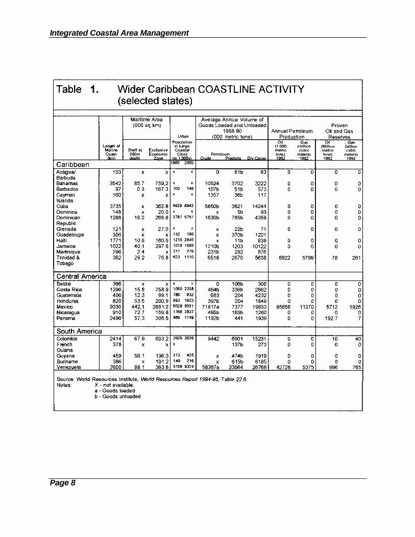
The 80 million inhabitants who live in the islands and coastal areas of the region'scontinental countries, and the approximately 20 million tourists who visit each year, aredependent on a healthy marine environment. Major marine-based indusries (Table 1) -- such as fisheries, sea transportation (upon which agriculture is dependent), oil andgas extraction, and, more recently, tourism -- have all played an important role in thedevelopment of the Wider Caribbean Region.
The Wider Caribbean, as a large ecosystem, is under serious threat. Its coastal marinesubsystems -- such as coral reefs, seagrass beds, estuaries and mangrovecommunities -- are now threatened by growing populations, unsustainable developmentpractices, insufficient management attention, and limited public understanding andappreciation of their important role. Yet, it is these same ecosystems that are the basisof the region's productivity, high biodiversity, and much of its food supply. They arealso a bulwark against natural disasters like hurricanes, provide for coastalstabilization, and are essential to key economic sectors such as tourism.
For the insular Caribbean, productivity is largely dependent on its vulnerable coastalmarine habitats. Most of the commercially harvested species of fish and shellfishdepend on mangroves, seagrasses and coral reefs at important stages in their lifecycles. Moreover, due to circulation patterns in this semi-enclosed sea, most fisherypopulations appear linked at a Caribbean-wide level.
There is, of course, greater productivity off the northern coast of South America due tohigher nutrient levels from rivers, estuaries and upwelling. However, the highproductivity of these coastal marine ecosystems is also threatened by lack of anadequate policy management and enforcement framework in which to manageresources for ecologically sustainable development. Habitat loss and environmentaldegradation is the primary threat to the region's marine productivity.
Integrated Coastal Area Management
Page 8

Wider Caribbean Region
Page 9
The real challenge lies in the improvement of coordinated support to plan, monitor,manage and restore coastal marine ecosystems in the Wider Caribbean Region.Coordinated regional management is essential as the efforts of individual countries toimprove environmental conditions cannot succeed if other nations continue tooverexploit and pollute the shared ecosystems. In this context, the CaribbeanEnvironment Programme provides an excellent framework for comprehensive,integrated, and coordinated efforts for the management and development of marine andcoastal natural resources.
2.2 Regional and Global Legal Instruments
As the increasing pollution of coastal and marine areas in the Wider Caribbean Regionhas become more apparent, legal instruments focusing on the reduction, abatementand control of coastal marine degradation in the region have been put in place.
The primary legal instrument of the Caribbean Environment Programme is theCartagena Convention (Convention for the Protection and Development of the MarineEnvironment in the Wider Caribbean Region), which was adopted in 1983 and cameinto force in 1986. Under the Convention, the contracting parties agreed to prevent,reduce, and control pollution from ships, land-based sources, air-bourne sources, andsea-bed activities. The Convention also commits the parties to preservation of uniqueand fragile ecosystems and habitats of endangered species. The CartagenaConvention provides a framework for the development of specific protocols.
The Protocol (to the Cartagena Convention) Concerning Cooperation in CombatingOil Spills also was adopted in 1983. Pursuant to this Protocol, the countries of theEastern Caribbean have collaborated, with assistance from the International MaritimeOrganization (IMO), in preparing an oil spill contingency plan for cooperating in theevent of a major oil spill. The plan establishes policy and addresses the responsibilityof participating states in response operations, requests for assistance, mutualcooperation, and the use of dispersants.
The framework for coordinated regional action on protected areas and biodiversity isprovided by the Protocol Concerning Specially Protected Areas and Wildlife(SPAW) to the Cartagena Convention, which was signed in Jamaica in 1990 (seealso Section 4.2.3). It is designed to create a network of national parks and protectedareas (including coastal and marine parks and protected areas) in the Wider CaribbeanRegion and to provide mechanisms to encourage and support their establishment andmanagement. The SPAW Protocol includes the requirement that common guidelinesand criteria be established for:

Integrated Coastal Area Management
Page 10
(i) the identification, selection and management of protected areas andspecies;
(ii) the establishment of protected areas, including parks, reserves, and sanctuaries; and
(iii) the evaluation of projects that could potentially have an impact onlisted areas or species.
The Cartagena Convention also provides for the development of a third protocol onland-based sources of marine pollution for the Wider Caribbean Region. Within theframework of the CEP's Action Plan, such a protocol (Protocol Concerning Land-based Sources of Marine Pollution) is presently under preparation.
On the global level, there are various conventions and treaties which encompass theWider Caribbean Region.
The United Nations Convention on the Law of the Sea was prepared by theinternational community over a period of 13 years in what was the largest, longest andmost complex international conference in history. UNCLOS III culminated in theadoption of the Convention (Montego Bay, 1982). This Convention contains ninetechnical Annexes covering all matters related to sea management and preservation.As such, it is complemented by a number of international agreements. On the 16th ofNovember 1994, the Convention of the Law of the Sea became in force.
The International Convention for Prevention of Pollution from Ships (MARPOL73/78), and its five annexes covering the various sources of ship-generated pollution,are designed to preserve the marine environment worldwide by preventing andreducing pollution from ships. This international convention was originally adopted bythe International Conference on Marine Pollution in 1973 and subsequently modified byProtocol in 1978. Regulations addressing the various types of ship-generated pollutionare contained in the five annexes of the Convention.
In 1993, the Wider Caribbean Region was designated a "special area" under MARPOLAnnex V. With this designation, strict regulations controlling the discharge of garbagefrom ships will become applicable in the Wider Caribbean Region.
The United Nations Conference on Environment and Development (UNCED) (Riode Janeiro, 1992) provides an international framework for the analysis of the criticalsocial, economic and environmental challenges inherent in the search for sustainabledevelopment. Agenda 21 of the "Earth Summit", as the Conference is also known,considered the conservation and management of resources and, in particular, Chapter17 considers the Protection of the Oceans, Seas and Coastal Areas, including theirliving resources. As a result of the UNCED Conference, Global Conventions on

Wider Caribbean Region
Page 11
Climate Change, the Ozone Layer, and Biodiversity were signed by many countries inthe Wider Caribbean Region.
2.3 The Coastal System
The coastal "zone", where the land meets the sea, comprises several types of systems,including socio-economic systems and natural systems (such as estuaries, watersheds,coastal lagoons, coral reefs and ocean areas out to 200 nautical miles). Each of thesesystems has distinctive properties; in the aggregate, they provide the typicalcharacteristics of the coastal area, which is the subject of management.
Integrated Coastal Zone Management (ICZM) involves the continuous management ofthe use of coastal lands and waters and their resources within some designated area,the boundaries of which are usually politically determined by legislation or by executiveorder. On land, the area included within the management unit may comprise the shoreand extend landward to some designated limit, such as the boundary of governmentaljurisdiction (e.g., a state or parish or an entire watershed). Seaward, the designatedarea may extend from the low tide shoreline to either the edge of the continental shelfor for 200 nautical miles, to the boundary of the Exclusive Economic Zone (EEZ).Consequently, a coastal zone -- the integrated management area -- is "... the band ofdry land and adjacent ocean space (water and submerged land) in which terrestrialprocesses and land uses directly affect oceanic processes and uses, and vice versa"(Ketchum, 1972). Figure 2 shows a cross section of a coastal zone, with options forseaward and landward boundaries.
2.3.1 Coastal Resources
Coastal resources can be regarded as commodities in the production of the goods andservices which make the coastline a popular and busy place. They include natural,human and man-made components:
o Physical/geomorphic elements. Comprised principally of fastland, beaches,headlands, coastal islands, peninsulas, tombolas, barrier reefs.
o Natural systems. A coastal zone contains a number of physiographic units orecosystems with particular biophysical properties and processes, includingflora and fauna and non-renewable resources. These units can be classified invarious ways, but the designation of a coastal area for management was andstill is largely politically determined, e.g., administrative boundaries.Ecosystem boundaries are now being reevaluated, however, as essential tomanagement for sustainability.

Integrated Coastal Area Management
Page 12
Figure 2. Potential Boundaries of A Coastal Management Area (adapted from Awosika, et al., 1993).NB. The landward boundary of the "coastal zone" is customarily established inland of the point shown inorder to incorporate some portion or all of the watershed area affecting the coastal area, or at someconvenient administrative or geographical boundary. For small island states in the insular Caribbean,the entire island could be considered a coastal area.
o Human resources. People living and/or working in coastal areas may beinvolved in the production of goods and services from that specific area (suchas the exploitation of oil and gas, fishing, agriculture), the creation of tourismand recreational facilities, the protection of areas below sea level, or theconservation of scenic locations. Human technical skills, cultural backgrounds,level of organization, etc. are important components in the way naturalresources are made accessible and used in the production of goods andservices.
o Constructed resources. Man-made structures change the accessibility of

Wider Caribbean Region
Page 13
resources, the spatial and time distribution, and the quality of available naturalresources. For example, roads increase accessibility; treatment plants improvethe quality of available water; dams in a river alter the distribution of waterflows over time; sea defenses create and protect areas for urbanization; andbeach nourishment creates recreation and tourism facilities. Man-madestructures also include urbanized areas with structures for housing andeconomic activities, as well as social/commercial infrastructure. Many of thesestructures often limit the access to the coastal resources or represent a threatto these resources.
o Cultural/heritage/archaeological resources. Sites and landmarks with particularcultural, historic or aesthetic qualities give a special character to a coastalzone, and determine whether it is attractive for tourism and recreation or forurban development. Submerged archaeological sites have resource value fromboth a cultural and touristic perspective.
o Oceanic basin system. Includes currents, waves, fisheries, tsunamis, andtides, among other things.
o Atmospheric system. Includes hurricanes and other seasonal storms, weatherand clean air.
o Viewshed systems. Scenic coastal assemblages of elements of all of theabove.
o Recreational systems. Assemblages of the systems above that contributed tothe mental and physical well-being of residents and visitors alike.
Coastal resources are often common property resources with open (free) access to allusers. Free access often leads to excessive use, and to the degradation or exhaustionof resources; this is the "tragedy of the commons". For example, the use of coastalareas for the disposal of the "leftovers" from society's activities may exceed theassimilative capacity of the coastal environment, leading to degraded water qualityand/or habitats. Management intervention is generally necessary to maintain toachieve desired levels of maximum sustained yield, as well as desired levels of qualityof coastal resources. There is a trend presently in many countries to allow forprivatization of these former common areas which leads to limitations on free access,with frequent unanticipated environmental costs.
Coastal resource systems are valuable natural endowments that need to be managedfor present and future generations. Coastal zones offer physical and biologicalopportunities for human use, and managers try to find the optimum balance betweenthese uses based on a given set of objectives. Concern is growing in particular aboutthe destruction of natural coastal ecosystems by the demands placed upon them bypopulation and economic growth. These natural ecosystems have considerable value

Integrated Coastal Area Management
Page 14
for sustainable extractive and non-extractive use which is often undervalued incomparison with other often non-sustainable uses.
In nature, the coastal system maintains an ecological balance that accounts forshoreline stability, beach replenishment, and nutrient generation and recycling, all ofwhich are of great ecological and socio-economic importance. These natural systemsare under increasing threat from unmanaged human activities such as pollution, habitatdestruction and overexploitation of resources.
In coastal rural areas, fishing of nearshore waters and farming of coastal lowlands arethe major economic activities supplying fish and agricultural products for subsistence ofthe inhabitants and urban centers. Activities that add further value to coastal resourcesinclude recreation and tourism, which have become major sources of domestic andforeign exchange earnings in many coastal nations.
The intrinsic economic value of coastal resources represents a "capital" investment forhumankind by nature. The goods and services derived from them are the "interest"generated by the investment. The principles of good husbandry are not restricted tothe agriculture sector alone, but can be applied to coastal resources with customizedtechnologies.
Traditionally, the management of coastal resources involves the resolution of bothlong- and short-range problems. Long-range problems include: possible climatechange such as sea level rise and changing hydrological patterns; the accumulation ofpollutants and their effects on species; and increasing development of coastal andinland areas with resulting modification of the quantity, quality, and time patterns ofinputs to coastal waters. Short-range problems include: storm damage; dredgingimpacts; and over-harvesting of fish, sand, corals, or mangroves. Management isessential to prevent, or at least to mitigate, the adverse effects of these pressures.
Coastal areas are rich in natural resources, which are often lost throughcounterproductive efforts to protect development in hazard areas from coastal storms.Beaches, dunes, and wetlands are destroyed both by construction of poorly plannedand located public and private projects and by subsequent construction of protectiveworks such as seawalls to armor these projects from coastal erosion and storm surges. Construction in these higher-risk areas interferes with the geological and ecologicalprocesses that maintain the natural protective and productive coastal systems.Estuarine wetlands are often damaged by dredge-and-fill activities. Seawalls andgroins may provide localized storm protection but also cause loss of beaches anddunes due to increased erosion from wave action and interference with normal patternsof sand transportation by ocean currents.
Coastal area management programmes can prevent the loss of natural resourcesthrough development regulations, proper monitoring and enforcement. By combiningpreventive measures such as shorefront building setbacks with restrictions on coastal

Wider Caribbean Region
Page 15
armoring, governments can protect the natural resource systems necessary to maintainthe beaches, as well as to safeguard future coastal development and infrastructure(see Box 1).
2.3.2 Coastal Ecosystem Management Issues
(1) Key Ecological Processes
Any coastal ecosystem management programme must look to, and protect, importantecological processes, i.e., the underlying factors which explain the high productionlevels of coastal seas such as:
a) the key role of fresh and marine waters in providing and renewingnutrients, organic material, and oxygen;
b) solar radiation which is maximized as an energy source because of thecharacteristic shallow depths of these areas; and
c) the high mixing rates which assist gas exchange, nutrient circulation andwaste removal.
Box 1. COASTAL CRISES
Common Problems and Solutions
ISSUES AND PROBLEMS EFFECTIVE ACTIONS
- Depletion of inshore commercial and recreational - Sustainable fisheries management for long-term fisheries from overfishing productivity; possible limited entry
Degradation of coastal habitats - Improved management of biodiversity
- Damage of coastal areas from uncontrolled - Control of coastal development through planning, development zoning and permitting procedures
- Beach damage from sand mining and vegetation - Management of tourism for minimal erosion and removal for resort development reduced environmental impact
- Water pollution from oil, sewage, urban - Improved control of watershed effluents and runoff and sediments urban waste disposal practices
- Harbor and estuarine pollution, congestion, - "Special Area" management planning, including use and siltation of EIA process, for harbors, wetlands, estuaries,
industrial sites, and urban areas
- Nutrient pollution of coastal waters from - Development of non-point source pollution agricultural fertilizers and pesticides control programme
- Loss of coastal wetlands and estuarine habitats - Establishment of no net loss policy for wetlands
- Loss of scenic landscapes and seascapes, and - Landscape management and easement strategies to historic areas protect scenic coastlines and historic sites

Integrated Coastal Area Management
Page 16
(2) Ecosystem Planning Boundaries
The complexity of biotic systems and the interrelatedness of their components requirethat each coastal ecosystem be managed as a whole system. Neither piecemealmanagement nor treatment of single components or single species will fully succeed.Furthermore, the major external sources of influence on coastal systems must beconsidered -- shoreland watersheds, shoreline areas, and offshore waters are all linkedto the coastal system. Therefore, the ecosystem defined must embrace a complete andintegral unit, one that includes a coastal water basin or basins and the adjacentshorelands to the extent that they have significant influence on coastal waters.
(3) Land-Sea Interactions
A major value of integrated coastal zone management is that it addresses the land andthe sea simultaneously. Linkages between the land and the sea preclude sustainabledevelopment of coastal/marine resources without coordinated management.
It is basic to coastal management to recognize how strongly activities on land affect thecondition of the sea. The sea is impacted by distant events that occur far inland -- riverdischarges, deforestation, land cultivation -- all may affect coastal ecosystems.
Conversely, the sea strongly affects the land and intertidal areas, for example, pollutionfrom tanker bilge washings or property destruction from hurricane storm flooding andwave action. The countering "natural defenses" of the coastline -- beaches, mangrovesand coral reefs -- can be extremely important for protecting shorelines and coastalvillages against storm waves and shore erosion.
2.3.3 What Does Coastal Zone Management Do?
Coastal zone management is a special planning process with a complex and dynamictarget area focused on the interface of land and sea, and embracing:
o some fixed, some flexible boundary concepts,
o an ecosystem conservation ethic,
o socio-economic goals,
o an active, problem-sovling, participatory management style, and
o a strong scientific base.
As such, coastal zone management represents many different things to differentpeople. To the conservation minded, the concept represents either a panacea for

Wider Caribbean Region
Page 17
every excess of the private sector or governmental agencies, or the solution to everyunsolved coastal-related problem. Others fear "management" as yet another intrusionby the government into the "rights of the individual", or the imposition of additional "redtape" and bureaucratic delay. It is often interpreted as "environmental determinism",the imposition of natural environmental values over all others.
Most early coastal programmes reflected an antecedent failure of the existing system ofnational and/or local development planning to respond to the visibly adverse effects ofcrowding, technology advancement, urban growth, privatization, and waste disposalpractices that were changing coastal areas. In the public's mind, there was a need toanswer the public policy question, "Who's minding the shore?" The answers were notencouraging and usually led to development of modest, narrow purpose, first-stageprogrammes with a limited agenda.
In a subsequent phase, community concerns influenced the coastal managementprocess to expand its purview to include:
o special area planning (e.g., problem solving for ports, industrial areas, oceanoutfalls, energy siting, tourism enclaves);
o systems planning (e.g., estuaries, coral reefs); and
o marine areas planning (e.g., fisheries reserves, marine parks, EEZ surveys).
Typically, particular government ministries, departments and/or agencies areresponsible for particular resources or uses. However, in some countries much of thecoastal zone is privately owned, and attempts by the government to guide themanagement of private lands can be a source of conflict. Under these conditions,coastal area planning has been severely tested and, in some situations, has had toconfront the loss of public support.
In reality, sound coastal zone management is none of these extremes. A successfulprogramme is based on a comprehensive and integrated planning process which aimsat harmonizing cultural, economic, and environmental values and balancingenvironmental protection and economic development with a minimum of regulation.Management without an appropriate planning process tends to be neither integratednor comprehensive, but rather a sectorial (and often ad hoc) activity. Any coastalinitiative must be liked to all phases of the planning process and pay particularly carefulattention to differences in scale for both planning and management.
Sound coastal zone management builds a dialogue which pools the knowledge of bothexperts and the public to produce a technically sound and clearly stated managementprogramme that has the widespread support necessary for programme approval andeffective implementation. The following standard goals and objectives help illustratewhat coastal zone management means.
Integrated Coastal Area Management
Page 18
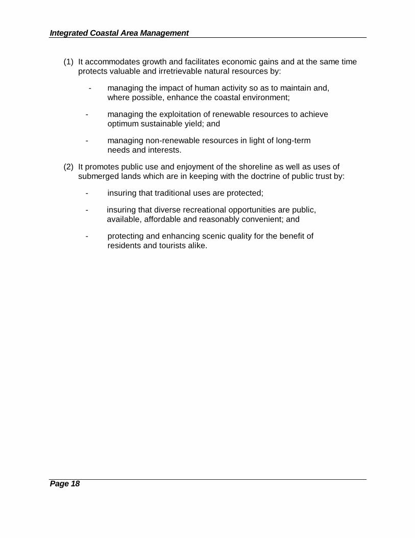
(1) It accommodates growth and facilitates economic gains and at the same timeprotects valuable and irretrievable natural resources by:
- managing the impact of human activity so as to maintain and,where possible, enhance the coastal environment;
- managing the exploitation of renewable resources to achieveoptimum sustainable yield; and
- managing non-renewable resources in light of long-termneeds and interests.
(2) It promotes public use and enjoyment of the shoreline as well as uses ofsubmerged lands which are in keeping with the doctrine of public trust by:
- insuring that traditional uses are protected;
- insuring that diverse recreational opportunities are public,available, affordable and reasonably convenient; and
- protecting and enhancing scenic quality for the benefit ofresidents and tourists alike.
Page 19
CHAPTER 3. INTEGRATED COASTAL MANAGEMENT PLANNING
3.1 From ICZM To Integrated Coastal Area Management (ICAM)
There is an emerging consensus -- one analyst (Cincin-Sain, 1993) calls it the newsynthesis -- which, since UNCED in 1992, has acquired the popular label "integratedcoastal area management", or ICAM.
What was for over two decades coastal zone or coastal area management has recentlycome to be referred to as integrated coastal area management. The new acronymICAM and the old CZM or ICZM are used interchangeably. There is no consensusabout the utility of adding the word "marine" to pair off with "coastal" and the word"planning" to pair off with "management". This document assumes the marine area issubsumed within the term coastal (which includes land and sea areas) and furtherassumes planning as a function is a given and ongoing prerequisite component to themanagement process.
This sub-section is about the characterization of ICAM and its "planning" tasks. It isalso about linkages with other national and local area planning activities -- hence theslight variation in wording in the heading.
The transition from the 1970's prototype, single-sector coastal management initiativesinto the more comprehensive, internationally accepted and more integratedprogrammes of today was based on a steady sequence of challenges and successes.Progress has been extraordinary. In just over two decades, an innovative planningmanagement concept for dealing with a very complex piece of global geography -- thecoastal zone -- has gone from theory to practice.
This reflects a wide international response to the following:
(1) The challenges posed by national socio-economic needs via a vis the coastalzone, i.e., changing user patterns of exploitation and expanding coastal, water-dependent demands (tourism and mariculture, for example).
(2) An emerging awareness of the value and importance of coastal areas tonational economic growth and well being, in company with a growingawareness of the short and longer term costs of environmental degradation andresource mismanagement as a constraint on development.
(3) A growing recognition that standard sectorial planning and its managementcounterpart have failed to deal effectively with coastal and nearshore issues,mostly by failing to address ecosystem needs and the husbandry of ecologicalservices.

Integrated Coastal Area Management
Page 20
(4) The international acceptance of the idea of cross-sectorial, interdisciplinaryplanning and comprehensive, if not fully integrated, management practices andprinciples in pursuit of more sustainable development (donor institutions worldwidehave generally been supportive of the principle and the practice, including planningfor coastal area management and its more integrated, recent iterations).
(5) That integrated coastal management planning must be recognized as an extendedand integral part of traditional physical planning. The opposite approach -- twoseparate and parallel activities -- will only lead to competition for human andfinancial resources and will create a misunderstanding among policy and decisionmakers, planners, scientists and the public about what ICAM stands for -- namely,to widen the geographic scope of the planning concept to include marine areas andland-sea interactions.
Testimony on the vitality and maturity of integrated coastal area management as anapproved and preferred governmental programme option is best found in the prominentvisibility given ICAM on the agenda of the United Nations Conference on Environmentand Development (UNCED) in 1992. The emphasis given the interplay of ICAM (orICZM) in national development planning, especially in Chapter 17 of Agenda 21,confirms the universally held view that the coastal zone will play a leading role inimplementing the sustainable development strategies so fervently desired by theinternational community (Vallejo, 1993).
3.2 The Concept of ICAM (or ICZM)
There is no shortage of definitions of "integrated coastal area management" (ICAM). Afew recent examples are provided.
[ICAM is a] dynamic process in which a coordinated strategyis developed and implemented for the allocation ofenvironmental, socio-cultural and institutional resources toachieve the conservation and sustainable multiple use of thecoastal zone (Sorensen, 1993).
ICAM is an adaptive process of resource management forenvironmentally sustainable development in coastal areas.It is not a substitute for sectorial planning, but focuses on thelinkages between sectorial activities to achieve morecomprehensive goals (UNEP, 1993a).
Integrated Coastal Zone Management (ICZM) has beenidentified as the most appropriate process to address currentand long term coastal management issues, including habitatloss, degradation of water quality, changes in hydrological

Wider Caribbean Region
Page 21
cycles, depletion of coastal resources and adaptation to sealevel rise .... (Awosika, et al., 1993).
Robert Knecht, a long-standing CZM professional and CZM programme director nowturned scholar, emphasizes a slightly more activist, interventionist definition as follows:
Integrated coastal management is a dynamic process bywhich decisions are taken for the use, development andprotection of coastal areas and resources to achieve goalsestablished in cooperation with user groups and national,regional and local authorities. Integrated coastalmanagement recognizes the distinctive character of thecoastal zone -- itself a valuable resource -- for current andfuture generations. Integrated coastal management ismultiple purpose oriented, it analyzes implications ofdevelopment, conflicting uses, and interrelationshipsbetween physical processes and human activities, and itpromotes linkages and harmonization between sectoralcoastal and ocean activities (Knecht and Archer, 1993).
Jens Sorensen (1993), another long-standing scholar of coastal zone affairs, offers amore detailed explanation, ascribing five attributes of ICAM as:
1. A dynamic process that continues over time (implying change, revision,adaptation, even error).
2. Involving a governance arrangement to establish policies for makingallocation decisions and the power to make such decisions.
3. A governance arrangement that uses one or more managementstrategies to rationalize and systematize resource allocation decisions(i.e., land use plans, impact assessments, regulations, permits, etc.).
4. Management strategies that rely on a systems approach, recognizinginterconnections among coastal and marine systems and subsystems(these include coastal watersheds, estuary circulation systems, thelongshore movement of sediments within littoral cells, populations ofspecies that are harvested for their commercial or recreational value, andwater supply, sewage treatment and highway systems).
5. Having a geographic boundary space extending from the oceanenvironment across the transition shoreline to some inner terrestrial limit(except on islands).

Integrated Coastal Area Management
Page 22
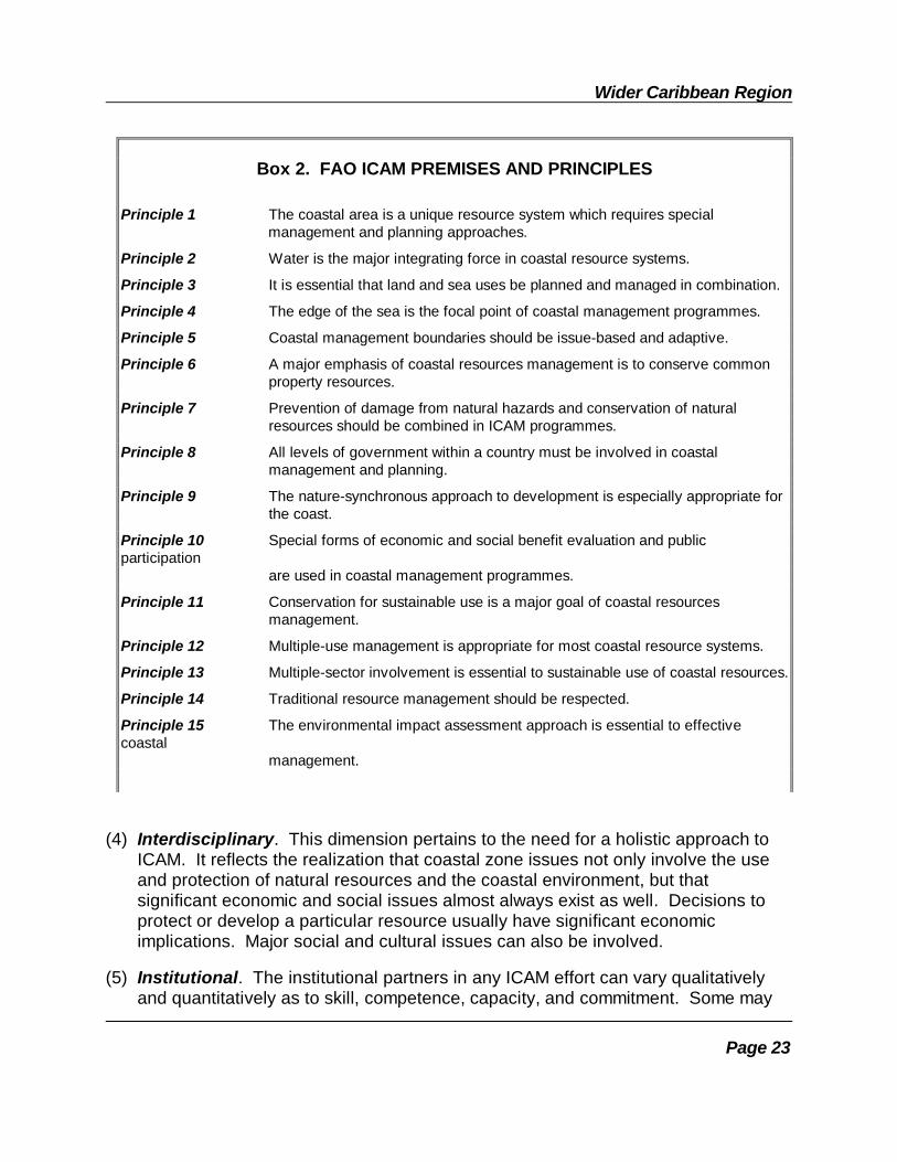
The developing literature on ICAM (or ICZM) worries excessively about what is and isnot truly integrated and truly coastal. For example, how does one classify a marinepark and protected areas planning effort on a coastline that uses integrated,interdisciplinary methodology? Should it be referred to as a legitimate ICAM effort, oris it an ordinary sectorial plan? Sorensen (1993) is correct when he says the essentialingredients are (1) a coastal systems perspective and (2) a multisectorial approach.(See also Box 2.)
3.3 Integrating Dimensions of ICAM
The dimensional aspects of ICAM are a function of the kinds of integration required,which set the pattern of outreach, peripheral involvement, and the nature ofpartnership, participation and negotiation with other coastal resource users andinstitutions. There are at least seven different kinds of integration (each of which hasits own dimensional limits (Knecht and Archer say there are only four, here presentedfirst).
(1) Intergovernmental. This dimension encompasses the necessary integration ofvarious levels of government into coastal management, especially between thenational level and regional/local levels. Determining the level and type of activeinvolvement of various governmental units, and providing the choreography fortheir participation in the various geographic segments of the coastal zone (seeFigure 2) is an integrative task, as it especially affects the enforcement side oflandscape and seascape quality controls, licensing, leases, permits, and riskmanagement.
(2) Land-Water Interface. Clearly, integration across the land-water boundary isbasic to the concept of coastal management. The coastal zone area to bemanaged is usually defined in terms of both a shoreland area (the uses of whichaffect the coastal waters) and a water area (the uses and disturbances of whichaffect the shoreland). Understanding the effects which traverse the land-waterboundary (in both directions) is of fundamental importance.
(3) Intersectorial. It has become increasingly clear that the rational management ofcoastal resources requires that all activities affecting such resources (or the coastalenvironment in which they reside) come within the "reach" of the managementprogramme. For example, dredging to create a deeper harbor and/or safernavigation channels can potentially affect habitats that are of critical importance tocoastal fisheries. Hence, such dredging must be within the policy and regulatorypurview of the coastal management programme.
Wider Caribbean Region
Page 23
(4) Interdisciplinary. This dimension pertains to the need for a holistic approach toICAM. It reflects the realization that coastal zone issues not only involve the useand protection of natural resources and the coastal environment, but thatsignificant economic and social issues almost always exist as well. Decisions toprotect or develop a particular resource usually have significant economicimplications. Major social and cultural issues can also be involved.
(5) Institutional. The institutional partners in any ICAM effort can vary qualitativelyand quantitatively as to skill, competence, capacity, and commitment. Some may
Box 2. FAO ICAM PREMISES AND PRINCIPLES
Principle 1 The coastal area is a unique resource system which requires specialmanagement and planning approaches.
Principle 2 Water is the major integrating force in coastal resource systems.
Principle 3 It is essential that land and sea uses be planned and managed in combination.
Principle 4 The edge of the sea is the focal point of coastal management programmes.
Principle 5 Coastal management boundaries should be issue-based and adaptive.
Principle 6 A major emphasis of coastal resources management is to conserve commonproperty resources.
Principle 7 Prevention of damage from natural hazards and conservation of naturalresources should be combined in ICAM programmes.
Principle 8 All levels of government within a country must be involved in coastalmanagement and planning.
Principle 9 The nature-synchronous approach to development is especially appropriate forthe coast.
Principle 10 Special forms of economic and social benefit evaluation and publicparticipation
are used in coastal management programmes.
Principle 11 Conservation for sustainable use is a major goal of coastal resourcesmanagement.
Principle 12 Multiple-use management is appropriate for most coastal resource systems.
Principle 13 Multiple-sector involvement is essential to sustainable use of coastal resources.
Principle 14 Traditional resource management should be respected.
Principle 15 The environmental impact assessment approach is essential to effectivecoastal
management.
Source: Clark, J., 1992. INTEGRATED MANAGEMENT OF COASTAL ZONES. FAO Fisheries Technical Paper 327.
Integrated Coastal Area Management
Page 24
require direct technical support or even financial support to do what ICAM needsdoing. Others may be in a position to make substantive, continuing contributions oftime, effort and custodial responsiveness for a given task with which the ICAMneeds assistance. The integration of these various kinds of institutions(governmental, non-governmental and private sector) into a programme is amanagement achievement.
(6) Temporal. ICAM's response for responsible and effective performance runs from ashort 24-hour hurricane warning to a 200-year storm planning regime for wave run-up and inland flooding. Ecosystems, resort tourists, fishermen and politiciansfacing elections have different clocks ticking. ICAM has to blend or integrate thesetemporally different planning perspectives into a coherent investment strategy forcoastal protection and development.
(7) Managerial. A basic element of an ICAM programme is the integrativearrangement of management responsibilities. Management arrangementscomprise institutional arrangements and management instruments. Institutionalarrangements provide an integrated framework within which the management tasksare carried out and the management instruments applied. This integratedframework includes:
- the structure of government and non-governmental organizations, includingmechanisms for linking responsible agencies and organizations indifferent kinds of integrative relationships;
- the set of laws, conventions, decrees and standards for environmentquality;
- the set of traditions and social norms such as customary laws; - NGOs and service organizations; and - international, bilateral and multilateral partners.
It is noted that the inclusion of NGOs and the local public in both the planningand management process is of vital importance for a successful ICAMprogramme. Commitment by the public to fulfilling the goals of ICAM, created byits participation in the planning process, is of particular importance in situationswhere the legal and administrative framework to implement and monitor the ICAMprogramme is weak or nonexistent.
(8) International. External coastal boundaries are often shared with adjacentcountries. On a regional scale, member states within a large marine ecosystem,like the Wider Caribbean, will of necessity find that the search for managementstrategies requires collaboration for effective ecosystem management, withinternational, bilateral, multilateral, and regionally focused NGO partners.
Wider Caribbean Region
Page 25
3.4 Organizational Aspects of ICAM
3.4.1 Management Boundaries
ICAM programmes inevitably involve the continuous management of use activitieswithin some designated area, which are customarily set by legislative or executiveorder. On land, the area generally comprises the shore zone (e.g., beach, lagoon,dunes, cliffs, etc.) and extends inland some specified distance -- often to a politicaladministrative boundary but sometimes to the upper reaches of tidewater or the entirewatershed. Seaward, the area may extend from the mean low water line to the outerlimit of territorial waters or the continental shelf or the outer boundary of the EEZ.Tentative planning boundaries are a defensible expedient, knowing that they may beadjusted in light of experience.
Figure 2 (in Section 2.3) displays a cross section of a hypothetical coastal zone area,showing various boundary options. Vertical dimensions are required to indicatesubmerged features and atmospheric hydrospheric interactions.
3.4.2 Programme Boundaries
Figure 3 displays a typical arrangement of the components for a generic CZMprogramme. At the core, there is a three-stage programme design and developmentprocess (marked 1, 2, and 3) and a fourth final implementation step.
A major defect in Figure 3 is the absence of feedback loops or linkages betweenprogramme stages and the evaluation component which is preferably a recurringelement built into each major segment. The figure also lacks provision for reviewing,updating and revising the plan on a regular basis. New information, new techniques,and changes in policies will necessitate revision after a number of years. If a regularreview and revision process is not undertaken, the plan will inevitably become outdatedand loose credibility with technicians, political leaders, and the general public.
A more detailed presentation of a programme development process customized to theWider Caribbean case is found in Chapter 4.
3.4.3 Jurisdictional Boundaries
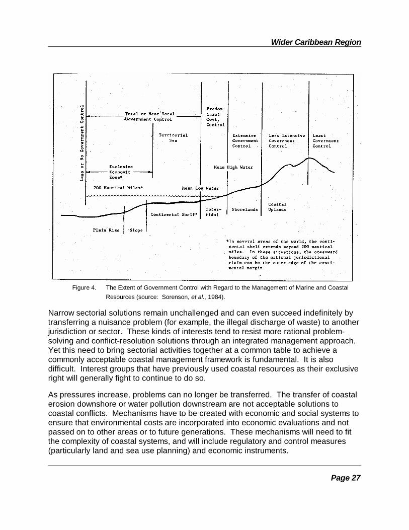
The interplay of multiple, often overlapping jurisdictions of various functional units andhierarchical layers of government -- each with some functional link to a segment of thecoastal landscape and seascape -- requires careful attention. A simplified graphicaldisplay of this jurisdictional variation is found in Figure 4. Government involvementvaries significantly within different parts of the coastal zone, which further complicatesthe integration task.

Integrated Coastal Area Management
Page 26
3.5 Advantages and Obstacles to ICAM
As previously noted, managing complex systems like those in the coastal zone worksonly with an integrated approach which brings together overlapping, often competinginterests from government, the private sector and the public. This sometimes can beacrimonious as individuals and organizations, set in their ways, do not easily or readilyperceive the reasons for joint problem solving or perceive much advantage in evenparticipating in discussions of things external to their interests.
Wider Caribbean Region
Page 27
Figure 4. The Extent of Government Control with Regard to the Management of Marine and CoastalResources (source: Sorenson, et al., 1984).
Narrow sectorial solutions remain unchallenged and can even succeed indefinitely bytransferring a nuisance problem (for example, the illegal discharge of waste) to anotherjurisdiction or sector. These kinds of interests tend to resist more rational problem-solving and conflict-resolution solutions through an integrated management approach.Yet this need to bring sectorial activities together at a common table to achieve acommonly acceptable coastal management framework is fundamental. It is alsodifficult. Interest groups that have previously used coastal resources as their exclusiveright will generally fight to continue to do so.
As pressures increase, problems can no longer be transferred. The transfer of coastalerosion downshore or water pollution downstream are not acceptable solutions tocoastal conflicts. Mechanisms have to be created with economic and social systems toensure that environmental costs are incorporated into economic evaluations and notpassed on to other areas or to future generations. These mechanisms will need to fitthe complexity of coastal systems, and will include regulatory and control measures(particularly land and sea use planning) and economic instruments.

Integrated Coastal Area Management
Page 28
Resource conflicts nearly always are rooted in human activities and with the severeand mushrooming competition for access, space and use privileges in the coastal zone,the task of finding rational solutions through integrated planning under ICAM appearsat first to be overwhelming, if not hopeless. But an open, integrated process like ICAMhas a hidden dividend -- it brings sectorial allies to the table as well as sectorialopponents. And the process of education, attitudinal change, and persuasion becomesless formidable and more feasible, in part, because it is more logical. Publicparticipation in this process also has advantages to the ICAM protagonist as supportersof the "resource" at risk can usually be enlisted in this process.
The number of government planning activities, mostly sectorial, that impinge upon orhave some type of interest in or limited responsibilities for coastal areas in a country isusually significant (see Table 3 in Section 2.8.3). There is inevitable overlap,fragmentation of responsibility and conflict. ICAM can help clarify these competinginterests and offers a neutral vehicle to help resolve the problems -- either in apartnership role with a lead sector or by negotiation for a coordinated approach leadingto a joint strategy to address the issue or problem. Conflict resolution will be adeveloped skill of any ICAM programme staff.
Governments, in some cases with the assistance and concurrence of quasi- and non-governmental bodies and even the business sector, already study, plan and administera variety of multi-layered planning activities, many of which touch the edge of the seaand the coastal zone.
ICAM needs to ferret out and familiarize itself with this matrix of planning goals,intentions, perspectives, and institutions. There are some shared interests. It is alsolikely that there will be differences -- even competition. Vested interests can beresilient, even stubborn.
There will also be, as another challenge for ICAM, a fragmentation of responsibility andperhaps some conflicts, not with ICAM but among the various government planningentities. Conflict resolution skills will be among those that are most scarce, yet mostneed by ICAM planners and managers.
Fragmentation among planning agencies and even among some management entitiesnecessitates integration -- integration between environment and development(sustainable development), integration among sectors, integration among ecosystemswithin the region. It has been argued that the best route to sustainable developmentlies in the direction of integrated resource management -- and an ICAM programme isan excellent learning vehicle in this regard.
There is, however, a risk of over-reaching, in the search either for ICAM programmeacceptance by the public or for an environmental cause larger than the coastal zone --like national sustainable development. Despite the temptation, ICAM needs to avoidbecoming (and avoid being perceived as) a national, all-purpose environmental
Wider Caribbean Region
Page 29
planning and management unit (although it might become part of one, a newenvironmental ministry for example).
3.6 ICAM and National Development Planning
One of the major challenges in the development of an ICAM plan is to relate it to andintegrate it with existing planning programmes. Many nations practice four types ofplanning that will directly influence the shape and direction of any ICAM planning effort:national economic planning, sectorial planning, land use planning, and special areaplanning.
While varying slightly from place to place, national economic or development planningdistinguishes itself by being countrywide in scope and by shaping and setting variousstate (and sub-unit) developmental goals, some in economic terms. It does this bysector, and by region in a larger country, aiming to increase economic growth,encourage investment, reduce income disparities, create employment, enhance foreigntrade (and exchange) and safeguard the general welfare of the population.
From the perspective of coastal resources, the ultimate objective of an ICAMprogramme is that it will become a functioning (and continuing) part of the nationaldevelopment planning process. By doing so, it would enable ICAM to reduce thenegative side-effects of prejudicial development activities by other sectors or areas (forexample, industrial wastes into estuaries or farm agrochemicals into upper watershedstream corridors). Even more positive would be things like the creation of a degree ofcertainty about coastal land development or the enhancement of national shore-protection measures.
The downside is that national economic plans lack flexibility, tend to be mechanistic,conservative and unimaginative about things like urban waterfront renewal, marineindustrial parks, marine recreation facilities, marine ecotourism, and so forth. Theseare the very things a forward-looking ICAM programme could engineer with the privatesector and a creative urban or regional development commission seeking imaginativeand productive ways to cluster compatible uses in a waterfront zone.
3.7 Sectorial Planning
Planning by sector is so standard a practice that virtually all multilateral banks, donororganizations and bilateral assistance programmes have structured the major portion oftheir investment and grant-supported activities along sectorial lines. Within the WiderCaribbean Region, sectorial planning traditionally combines forecasting for capitalinvestment requirements, physical planning, infrastructural needs assessment andimplementation, including dialogue with donors, investors and developers. Sectorial

Integrated Coastal Area Management
Page 30
planning sometimes mirrors national economic planning but with a special topical orthematic focus -- on agriculture, on tourism, on transportation, on health, on educationand so forth.
For most countries in the Wider Caribbean Region, the sectors with the greatesteconomic relevance to coastal management are fisheries, transportation (or ports) andtourism (see also Table 2). The sectors with the most environmental impact on coastalresources are agriculture (because of agrochemicals and mariculture), mining (becauseof petroleum), industry and commerce (because of hazardous and toxic materials), andwhatever sectorial planning unit large coastal cities fall under (because of solid andliquid waste streams). Most of these sectors have some dependence on an efficientlyfunctioning natural resource base. Thus, ICAM's success will depend significantlyupon changes in attitudes and perspectives among the sectorial planning contingent(Examples of the issues requiring sectorial-ICAM policy coordination can be found inBox 3).
Several nations have recognized the importance of environmental factors and havetaken steps to include them in "broad-scope" sectorial planning. In the NorthernCaribbean, for example, fishery plans for individual species, prepared by the CaribbeanFishery Management Council (CFMC) under the direction of the U.S. Marine FisheriesService (NOAA), are based on environmental system analyses that take in accountsustainable yields, recruitment rates, water quality and habitat quality (Sorensen, et al.,1984).
Table 2. Sectorial Planning in the Coastal Zone.SECTORS OFTEN SPECIFICALLY RELATED SECTORS RARELY SPECIFICALLY RELATED TO THETO THE COASTAL ZONE OR OCEAN COASTAL ZONE BUT MAY HAVE DIRECT IMPACTS
1. Naval and other national defense 1. Agriculture; mariculture operations (e.g., testing, coast guard, 2. Forestry customs) 3. Fish and wildlife management 2. Port and harbor development 4. Parks and recreation (including shipping channels) 5. Education 3. Shipping and navigation 6. Public health (mosquito control, food) 4. Recreational boating and harbors 7. Housing 5. Commercial and recreational fishing 8. Water and pollution control 6. Mariculture 9. Water supply 7. Tourism 10. Transportation 8. Marine and coastal research 11. Flood control 9. Water supply 12. Oil and gas development
13. Mining14. Industrial development15. Energy generation
Source: Awosika, et al., 1993.
Wider Caribbean Region
Page 31
Given that most major ports are located in estuaries, port expansion is likely to affectfringing wetlands, pollute water and destroy productive benthic communities. Inaddition, industrial facilities conflict spatially with public recreation or commercialfishing and limit access to the shore. Port management, as it deals with the recurringissues of channel maintenance, dredging, land fill, and the handling of toxic material inbulk, is a matter of concern to a coastal authority responsible for the largerencompassing coastal zone in which the port is located.
In another sector, successful tourism development in the Wider Caribbean Regionrequires a mix of hotels and shops, infrastructure (water, sanitation, roads, ports), andan accessible, relatively unspoiled natural environment. These goals can conflict witheach other and with development plans in other sectors. The relatively recentemergence of ecotourism as a sub-sector suggests that the industry's environmental
Box 3. SECTORIAL ICAM POLICY COORDINATION
1. Growth vectors (especially urban housing, industry, commercial centers) should be closelycoordinated with utility and other infrastructural capacity limitations. Setting preliminaryzonal and sub-zonal coastal carrying-capacity limits for sectorial planning guidance warrantstesting.
2. Industrial and commercial siting in coastal areas (tourism, manufacturing, merchandizingcenters) should reflect documented water-dependent use requirements.
3. Public access ways and "rights of way" to beaches for the public should be confirmed oracquired, developed, maintained, and access rights set as conditional requirements in allmajor coastal permits, including subdivisions.
4. Land reclamation requires careful interaction of engineers, environmental scientists, andplanners to minimize adverse impacts on adjacent and target coastal ecosystems.
5. Public fishing facilities and boating access points on the shoreline should be folded in todomestic recreational, tourism and fisheries planning initiatives.
6. Wrecked and grounded vessel removal from shorelines and beach areas requires acooperative understanding between public works, public safety, the port authority, legalagencies, and ICAM. Instruments should be in place as a contingency planning procedure.
7. Oil spills require a framework agreement similar to #5, with the addition of the naturalresource agency or fisheries department, public health, and tourism.
8. Coastal agriculture and forestry should be the subject of two understandings between theresponsible government ministry or department and ICAM regarding: (1) reducingagrochemical non-point source runoff and (2) the positive effects of maintaining agriculturalareas as open space and a desirable landscape feature preventing strip development alongcoastal roads and shorelines; and (3) reduction of coastal pollution from sediment runoff.

Integrated Coastal Area Management
Page 32
excesses may in a longer perspective be diminished.
When it is well done, broad-scope, sectorial planning begins to use the language andprinciples of ICAM. This is a nearly ideal basis for an optimum planning relationship --a "nested" set of compatible plans.
Broad-scope sector planning represents a marginal change from the status quo. Sinceinstitutions tend to make only marginal adjustments when confronted with the need forchange, broad-scope, single-sector planning is the most likely management strategy tobe implemented. For example, Colombia has developed broad-scope sectorial plansfor marine and coastal research. Coordinating organizations have been established,linked to the national economic planning programme designed to develop uniqueColombian marine and coastal resources.
Fortunately, broad-scope sectorial planning can and often does serve as a transition tomore integrated management planning along the same lines as ICAM. If a governmentagency broadens its horizons to assess the full range of impacts associated with itsprojects, and this wider perspective produces a net benefit to the agency, this positiveexperience should make the agency more amendable to taking the next step towardsintegrated planning. The major disadvantage of broad-scope sectorial planning is theperpetuation of non-integrated, single-purpose programmes.
The process of change from narrow to broad-scope sectorial planning is greatlyenhanced and accelerated by a national requirement for environmental impactassessments for all new, medium to large projects and programmes, assuming theprocedure more or less meets international standards for scoping, formats, coverage,documentation, and review of alternative scenarios.
There are some land-based practices which impinge on coastal areas:
(1) Urbanization
Coastal cities dominate both population and economic growth in much of the WiderCaribbean Region. Growth impacts and waste streams from these expanding urbanareas are leading to serious environmental degradation -- in particular, water pollution. Public institutions for managing waterfront development, population expansion,industrial effluents, and municipal waste discharges on land and in harbors andestuaries have been overwhelmed by the dimensions of urbanization, and managementfailures are common.
Additionally, rapid tourism growth, with high-volume waste streams and a preferencefor seacoast locations, and inappropriate land development control practices generallycombine to make the problems of urbanization even more difficult. ICAM technologiesfor Wider Caribbean harbor cities are therefore both a pressing and especiallychallenging task.

Wider Caribbean Region
Page 33
(2) Fisheries
Often housed within a ministry of agriculture with its own marine experts and biologists(seldom ecologists), its own tradition of sustainable-yield sector planning, and its owngovernment subsidies (e.g., research, duty-free gear), fisheries units tend to feelisolated, act independently, ignore overharvesting signals, and will often opposeinshore ecosystem management which would constrain, if not eliminate, overfishingand even -- as in Bermuda recently -- prohibit all pot or trap fishing for reef species,thus shifting the effort and emphasis to demersals and offshore shelf stocks caught bymore selective handlines, deep set traps and longlines.
(3) Public Sector Enterprises
Government corporations engaged in or linked to resource management or resourceharvesting enterprises, like agricultural marketing boards, cooperatives and othergovernment-run enterprises, traditionally lack an interest in and funds for seriousenvironmental protection measures. ICAM's concerns for excessive upland andshoreline application of agrochemicals, for example, will not be universally popular withsuch public sector enterprises. Privatization of these, however, is being encouraged bymost of the multilateral banks, with as yet unknown implications for coastalenvironments.
(4) Agriculture and Forestry: Watershed Management Problems
Although somewhat removed from the coastal zone in larger countries, watershedareas involved in production forestry and agriculture are nonetheless a problem.Eroded sediments and agrochemicals from upland areas, in combination downstreamwith urban run-off and its nutrient loads, are threatening and sometimes literally killingcoastal reef, seagrass and mangrove systems.
Non-point source pollution, treated as an externality by agriculturalists and foresters,needs to be brought under control in Wider Caribbean countries, and ICAM needs tobe ready to assist. Again, agriculture is one of the most significant but not the onlyoffender, as unpaved roads (the responsibility of public works ministries) are big-timelosers (of sediments) which eventually reach coastal ecosystems. Actually, unpavedroads on steep slopes with regular vehicular traffic are the worst offenders, but it isimpossible to identify a single "sector" as the offending authority.

Integrated Coastal Area Management
Page 34
(5) Mariculture
Mariculture is not a major coastal player in the Caribbean, although mariculturalactivities -- again, often under the aegis of a ministry of agriculture -- are found inperhaps half the countries in the region, including some important areas of shrimpfarming in coastal regions. Problems associated with this type of activity aredestruction of mangroves and changes in water fluxes and current patterns. It isimportant that a proper management plan be in place before mariculture activities areundertaken, in order to avoid the destruction or degradation of coastal resources.
As these brief reviews of five, perhaps atypical, sectorial interface problems suggest,ICAM managers can expect some delay in the search for an accommodation withsector planners who tend to narrowly define their domain.
3.8 Land Use Planning
Land use (or physical) planning is customarily national in scope but often locallymandated. Normally accompanied by a set of regulations, the land use planningprocess sets the type, intensity, size, and rate of development and protection orconservation for a specified area. Most coastal zones, most urban, residential andtown areas are covered by land use plans with broad goals and objectives designed toshape planning decisions. Plans, guided by definitions and standards, usually comewith zoning maps which make use of designations by class (e.g., residential,commercial) for each numbered and mapped land parcel.
Several countries in the Wider Caribbean, as former colonies, know land use planningas town and country planning, a tightly structured and orderly inventory, survey andland allocation process leading to the production of maps for local political jurisdictions. Also included are outlines of anticipated changes including proposed infrastructuredevelopment and phasing schedules. This leads to a public vetting followed byrecommendations to the relevant Minister for approval (this is sometimes the director ofthe planning agency who reports directly to Cabinet). In the smaller Eastern Caribbeanislands, this process has been significantly abbreviated in many plans where the townand country planning office has functioned as a planning secretariat for the PrimeMinister's Office or the Cabinet, with little or marginal community involvement. Thissystem does not deal easily with waterfront development, coastal systems, submergedlands, shoreline dynamics or hurricane impacts.
At least three countries on the rim of the Wider Caribbean have amended or modifiedtheir town and country planning programmes to shape new policies for land usecontrols within a delineated coastal area (Awosika, et al., 1993):
o The Bahamas prepared development plans on an island-by-island basis,treating coastal areas as a separate planning area.

Wider Caribbean Region
Page 35
o Jamaica prepared a plan for coastal management which endorses "... theevaluation of sensitivities and classification of areas of environmentalconcern."
o Guatemala has provided a different approach, in a shoreland use planningstrategy wherein the coastal area extends three kilometers inland fromthe seashore and is treated as a separate, special zoning area.
A new approach -- overlay zoning -- is being used to guide planning for sensitive areas,i.e., those needing extra protection, by the imposition of special restrictions (such assetback requirements or retention of wetland habitats). These extra requirements arein addition to existing standard regulations. An incentive strategy has also been usedto facilitate cluster zoning or a land use designation that permits greater densities forcertain types of development on coastal frontage, thereby encouraging investment anddevelopment of high priority recreational and commercial facilities (a public fishing pier,for example, as a recreational structure).
Land use (or town and country) planning provides a reasonable mechanism forresolving land use conflicts arising on a shoreline or linked to inland activity that affectsthe coastline. What is essential in this context is strong zoning with few loopholes, aswell as standards for pollution emissions and other kinds of control measures to reducecoastal degradation. Programmes organized at the national level provide anopportunity to deal with conflicting multiple-use circumstances in a consistent manner.Precedents for experiences in another area can be instructive.
Once an ICAM programme is planned, a strategy for opening a cooperative dialogueand establishing a working relationship with the local and national land use planningofficials is very important. ICAM needs to see stronger planning policies as a positivecontribution to the mission of coastal protection. With overlay zoning, the specialneeds of ICAM can be served in special cases as a retrofit or export situation. In fact,the ideal situation is for the ICAM process to be included in the land use planningprocess as an integral part. In particular, this applies to the smaller island states andterritories in the Eastern Caribbean where the entire island can be considered a coastalarea.
3.9 Special Area Planning
Special area plans are for areas, issues or programmes smaller than the nation butlarger than a single local jurisdiction. The distinguishing feature of these kinds of plansis geographic scope. The boundaries are usually intended to capture:

Integrated Coastal Area Management
Page 36
(1) A specific resource or issue (like pollution) or transport network ordistinctive feature (like a park or protected area) that crosses one ormore administrative state or local boundaries; or
(2) A significant natural resource such as an embayment, a river basin, anestuary, or a mangrove system.
They can be single-issue or multi-issue driven. They are becoming very popular withthe rising interest in landscape features like estuaries, watersheds, or biospherereserves (see also Section 5.2). They might even focus on coastal forests or asubterraneous cave system.
Most special area planning programmes and products have a landward focus andseldom address water-related issues. One exception to this is the APC (Area ofParticular Concern) planning strategy employed under the U.S. Virgin Islands CZMProgramme. Another is Puerto Rico, where a new special area estuarine managementplanning initiative is underway for San Juan Harbor and its estuarine environs. This isbeing done under an experimental, multi-agency estuarine management programme.
With an international special area context, it is possible to address and resolveproblems faced by entire ecosystems, such as a shared trans-boundary resource (forexample, migratory sports fish). Very often these issues cross a number of jurisdictionsand can only be effectively addressed with a regional geographic focus. Coastalmanagement institutions organized at the regional level often present opportunities forlocal authorities and officials with responsibility in various sectors to cooperate andresolve common problems. A small-scale programme can serve as a model that can betested, modified and perhaps extended to other regions.
3.10 Coastal Planning and Disaster Mitigation*
Coastal areas present a genuine planner's paradox. They are among the mostattractive for new development, especially in the tourism-driven economies of thetropics, but the siting of facilities along the coast will increase the exposure of peopleand property to the cumulative impacts of coastal storm damage. Public and privatesector investment alike tend to cluster in high-risk concentrations close by the sea, onurban and suburban coastlines, on exposed headlands, and even in the high-risklowlands situated landward of almost any extended system of
* Portions of the following section were adapted from: Brower, D., T. Beatley, and D. Blatt, 1987. Reducing Hurricane and CoastalHazards Through Growth Management. Center for Urban and Regional Studies, University of North Carolina at Chapel Hill, USA.
Wider Caribbean Region
Page 37
beaches. Yet public policy in most Caribbean countries, continental or insular, doeslittle to discourage development in hazardous areas along exposed coastlines andflood-prone estuaries. On occasion, it may inadvertently encourage the practice.
It is difficult to explain this compelling pull of the edge of the sea but it is real andpervasive and growing. For some, of course, it's the urban community, employmentand city life, not the sea, that is the attraction But for the coastal planner trying toidentify and set aside coastal sites for truly water dependent uses (like marinas, resorthotels and recreational watersports facilities), the competition is fierce and userconflicts are inevitable as investors seek to develop ever more exposed and vulnerablesites, passing the risk along to an uninformed buyer. This disproportionately rapidgrowth of population in coastal areas makes high density coastal areas morevulnerable to disaster than many inland areas.
Land use planning and development management, when done together and informedby sound marine engineering advice, can, in fact, shape growth in coastal areassufficient to offer government officials a practical and feasible way to mitigate thedestructive effects of hurricanes and other severe coastal storms. Where coastalplanning and the development control process are well informed and effective,developing coastal areas can be orderly, highly productive zones of rationed benefitsand managed competition providing steady flows of enhanced revenues for the state.Conversely, where there is no such vision and no mitigation planning, and the coastalzone remains unmanaged, public sector revenues diminish and the full potential of thisotherwise valuable resource will remain unrealized.
3.10.1 Coastal Hazard Mitigation As A Policy Issue
Both public officials and private developers confront the dual task of making the coastaccessible to the people while protecting them from the dangers of coastal storms. Thepolicy challenge lies in striking the appropriate balance between coastal developmentand hazard mitigation, between economic growth and public safety. Conflict can occurwhen governments attempt to implement programmes that intervene in the market andeven restrict private property rights in order to guide development into safe patternsand protect the resource user/consumer.
A hurricane or severe coastal storm in an undeveloped area affects only the naturalenvironment; for a disaster involving injury, death, and property destruction to occur,there must have been human decisions to develop hazard-prone areas in the path ofpotential storms. Otherwise such natural events would have more limitedconsequences. Three types of coastal storm impacts argue for governmentintervention into coastal development processes:
- threats to public health, safety, and welfare;
Integrated Coastal Area Management
Page 38
- costs to taxpayers for disaster relief and protection; and
- losses of irreplaceable natural resources.
All of these impacts can be reduced by enacting and implementing effective publiccoastal storm hazard policy.
Concern with natural hazard mitigation policy is relatively recent. To understand therelationship of mitigation to other disaster management activities, it is necessary toreview the accepted natural hazard management model. This conceptual modelconsists of a four-stage process centered on an emergency event or disaster, such asa storm. These stages taking place before the disaster are termed the mitigation andpreparedness stages; those after the response and recovery stages. In practice, thestages are not distinct. For example, mitigation overlaps preparedness and recovery.
Mitigation includes long-term actions to prevent, avoid, or reduce theimpacts of a hazard. Mitigation takes place both before a disasterstrikes and during the recovery phase after a disaster in anticipation ofthe next disaster. It is aimed at reducing the vulnerability of both peopleand property to injury from the hazard. It lowers risk.
Preparedness includes the short-term activities undertaken after adisaster warning is received, such as evacuating exposed populationsand attempting temporary property protection to save lives and reducedisaster damage.
Response includes the short-term emergency aid and assistance actionsfollowing the disaster strike. It is aimed at search and rescue, provisionof food, shelter, and medical facilities, restoration of public services,removal of health hazards, and clearance of debris.
Recovery includes the immediate support necessary to restore minimumoperating conditions and the longer-term actions to return the communityto normal. Recovery combines rebuilding with opportunities forcommunity efforts to learn from the experience and by the application oftighter, more focused development controls to reduce the risks of futuredamage in the coastal areas.
3.10.2 Risks and Mitigation
Risk management (discussed in Section 5.6) can provide only probabilities of risksoccurring and only broad estimations of their consequences. Oil spills are a goodexample. Three steps can be distinguished in the risk management procedure: (1)identification of major hazards, (2) assessment of the potential of individual hazards,

Wider Caribbean Region
Page 39
and (3) formulation of a plan that integrates the various management approaches torisks.
Mitigation of risks from hazards due to industrial, energy, transport and other activitiesis normally based on a multidisciplinary approach which takes into account all types ofhazards existing in a special coastal area. A specific method for dealing with industrialrisks, APELL (Awareness and Preparedness for Emergency at Local Level), has beendeveloped by UNEP. The main responsibility for carrying out within ICAM the threesteps in risk management specified above lies at the sub-national and local level. Forbroad risks like oil spills, national authorities should be responsible for overallcoordination, and institutional and legislative aspects. ICAM personnel should beactive partners in this process to reduce shoreline and shore-zone damages.
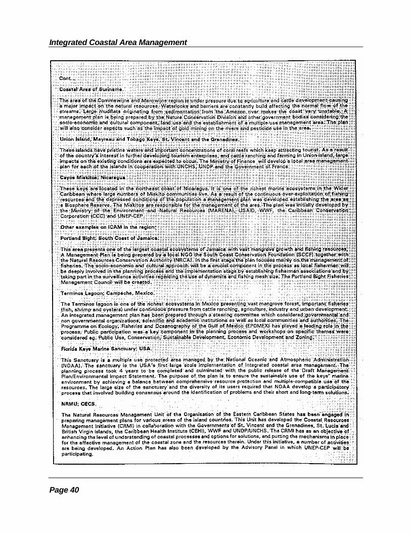
Integrated Coastal Area Management
Page 40
Page 41
CHAPTER 4.DEVELOPMENT AND IMPLEMENTATION OF ICAM PROGRAMMES
This section outlines a model process for developing and implementing an ICAMprogramme. It is a prototype approach which may be difficult for many countries to fullyemulate. Nevertheless, this section could serve as preliminary guidelines for countriesin the Wider Caribbean Region seeking to improve existing coastal area managementprogrammes. It is not intended to meet the requirements of all, nor is it suggested thateach step must be followed exactly as presented.
A four-phase process is suggested for the development and implementation of ICAMprogrammes; each phase is presented in detail in the four sub-sections which follow.
Phase 1 Opening or programme initiation phase during which the pro- gramme focus is set, issues reviewed, goals and objectiveses- tablished, and preliminary planning put in motion.
Phase 2 A programme analysis phase during which a number of parallel investigations are carried out which determine what problems will be addressed and what actions are needed under the ICAM programme.
Phase 3 A programme design phase during which a coastal management plan and related planning tools are assembled.
Phase 4 The final phase during which the coastal management plan is implemented, with ongoing provisions for programme evaluation and modification.
4.1 Programme Initiation: Phase 1
There is a general agreement among coastal area programme specialists that there isno unique best scenario for the start-up and implementation of a new coastal areamanagement programme, integrated or otherwise. In several case studies doneantecedent to World Coast 1993, the International Conference on Coastal ZoneManagement held in the Netherlands, it was evident that a wide variety of successfulprogramme initiatives exist but that they differ widely. In fact, it was "... evident that themost important lesson to be learned about ICZM [Integrated Coastal ZoneManagement] arose from the differences between successful approaches" (Awosika, etal., 1993).
This is, of course, a favorable finding as it suggests there is a reasonably broad set oftactical options, tools and approaches that the would-be coastal programme

Integrated Coastal Area Management
Page 42
Figure 5. Elements of Opening Phase for An ICAM Programme: Phase 1.NB. Each phase presumes and requires regular dialogue with stakeholder groups and local community leaders.
planner can choose from, selecting those that appear best suited to local conditionsand circumstances. However, this also suggests the need for a pre-project review ofwhat has worked elsewhere and under what specific conditions comparable to thoseprevailing locally.
This section outlines some of the pre-start up optional activities that have proveneffective as first-stage, constituency-building and energizing procedures for thedevelopment of ICAM programmes. See Figure 5.
4.1.1 First Steps: Preliminary Tasks
Developing the idea for improved coastal area management in any particular country orlocal administration, by persuading that country to restructure itself in favor of a new

Wider Caribbean Region
Page 43
integrated approach to coastal system planning, is a relatively easy task. This task isespecially easy if coastal zone resources are in difficulty and there are unresolvedproblems that adversely affect beach goers, tourists, fishermen, boat owners, hoteliers,and so forth -- in other words, people who expect to enjoy or to profit from the use ofcoastal resources. These people are relatively easy to persuade that the "idea" is agood one, and that it will lead to better planning and management, and more order andfewer losses.
But development of the idea inside the government structure by those technically incharge of the coastline or coastal resources is more difficult, as changing the statusquo generally is.
(a) ESSENTIAL PREREQUISITES (OVERVIEW)
First, selecting and legitimizing the initial leadership "team" -- for the complex task ofexplaining and justifying to the national government the need for rethinking, rearrangingand, when necessary, reforming its approaches for managing the coastal zone -- is atbest a complicated business, not unlike the assembly of a team trying to elect a winningreform candidate to public office. The analogue can be instructive.
Second, institutional (organizational) support arrangements are of vital importancefrom the outset for the planning phases of programme development. Thesearrangements are critical for issue identification, for improved technical inputs, and forenhancing public perception about the integrity and legitimacy of the endeavor.
Third, it is important to establish government's formal approval by its authenticating thelegitimacy of the antecedent study and planning effort as part of a process that leads toa formal plan of action. The formal plan is destined to be presented for review andapproval by a high-level unit or branch of government, such as the cabinet orparliament, as well as by the local coastal authorities. This does not have to beaccomplished at the very beginning of the process but could wait (1) until a strategicmoment or (2) for establishment of sufficient programme credibility to gain governmentendorsement.
Fourth, it is important to develop a stakeholders' strategy by bringing coastal area landand facility owners, resource users, and coastal interest groups, including localauthorities, into the dialogue concerning programme design and development.
Fifth, it is important to develop a public awareness strategy to both publicize andupgrade the agenda of relevant coastal "issues", and to build a constituency amongnon-stakeholder communities by facilitating their direct involvement in both theplanning process and subsequent implementation and monitoring.

Integrated Coastal Area Management
Page 44
(b) INITIAL LEADERSHIP: THE ICAM STEERING COMMITTEE
The initial leadership team (established as a steering committee) can be either formallyor informally constituted, and could be appointed by a senior government official or besponsored by a relevant ministry of agency (e.g, a national or regional planningcommission, for example). The sponsor could also be a group of volunteers assembledunder the aegis of an appropriate institution, such as a marine research institute oruniversity. The leadership team needs to have broad expert representation fromgovernment, industry, academia, tourism, shipping, fisheries, selected coastalcommunities and user-group institutions, the port authority, and national, local orregional planning units.
The original stimulus could arise from coalesced local coastal interests, aggrieved ornot, or from national interests (political, economic, environmental). Such a team shouldideally reflect a bias toward being multidisciplinary, a mix of practical and theoretical,engineering and policy. It should not be too large, and technical experts can beattached on an ad hoc basis as needed. Its primary function is as a steering group anda recruiting vehicle to enlist counsel, logistical support, advice, and input from a broadspectrum of the community, tapping its resources to make the undertaking a broad,community-based joint undertaking with government.
While it might be assumed there will be one national steering group which will beconvened to lead the planning effort, this is a decision that needs to be made in eachcountry. The steering committee's workload may be greatly eased if local institutionscarry some of the burden. For smaller island countries, a single national steeringcommittee or commission would be sufficient. It would probably operate with atechnical sub-committee, as a special working group.
For larger countries, and especially the continental countries in the region, a nationalsteering committee or commission might divide its work with a separate, more seniorpolicy committee, comprised of both political leaders of major national departments,ministries or semi-autonomous agencies, as well as state, provincial or local leaders. Amore junior technical planning group or sub-committee could be assembled to providedrafting and review counsel. Again, these determinations will have to made in eachtarget country.
One of the more important first tasks of the steering committee organizing the ICAMprogramme is to assemble a tentative but broad list of coastal and marine resourcemanagement issues, both documented and perceived. Input should be informallysolicited from the committee's own members and from a reasonably small group ofcoastal and marine experts, leaders, scholars, and professional planners.
Sorensen, et al. (1984) identified four types of issues that can be useful:

Wider Caribbean Region
Page 45
1. societal demands for the goods and services produced in the coastal zone;
2. conflicts between users, e.g., the drainage or reclamation of wetlands, dredgingof harbors for the development of tourism facilities, or inadequate treatment ofsewage wastewater may result in damaged reefs and reduced fish stocks;
3. the effects of non-product outputs on the state of the natural system, e.g.,coastal hazards caused by natural processes (shore erosion, hurricanes, riverflooding, landslides) may affect human survival and may destroy all types ofdevelopment;
4. opportunities, e.g., development and/or planning needs, such as mariculturedevelopment plans, infrastructure for tourism development, planning processesfor the privatization of coastal lands.
Converting the findings into a consolidated and ranked priority issues document is thenext step which should be done as expeditiously as possible so the draft list can becirculated among stakeholders, government officials and others for a further refinementand expansion. Following this, the document then become the basis for broadercirculation for public review and discussion. Ranking procedures for selecting priorityissues should include estimates of the following:
- the quantifiable and non-quantifiable costs arising from the issue;
- the distribution of costs among sectors of society;
- the time and budget required to resolve the issue (such as for datacollection and information analysis);
- the likelihood that the issue will be resolved in a relatively short time (oneor two years) if an adequate budget is allocated.
Once this is done, the universe of issues can be used to shape the scope of the ICAMstrategic plan, to define information needs and to help set programme internal andexternal boundaries. This is discussed in more detail in Section 4.3.
Issues, once identified and ranked, have special value as programme evaluation tools. They form a map of intended achievements, namely, the resolution of the issue or atleast its amelioration.
(c) THE PRELIMINARY OR ADVANCED PLANNING TEAM
In order to facilitate coordination for ICAM planning, a planning team, under the ICAMsteering committee, should be established and assigned responsibility for the actual

Integrated Coastal Area Management
Page 46
work of the committee -- in effect, a working secretariat. This team would beresponsible for the practical coordination of input and assistance from cooperatinginstitutions, agencies and other sources of expertise. The composition of the planningteam could include a marine biologist, a physical planner and an engineer, plusdraftsmen and secretarial support.
(d) INSTITUTIONAL ARRANGEMENTS
Quasi- and non-governmental institutions, such as marine and coastal researchfacilities, academies of science, and university marine science and engineering units,have the expertise, the information base and flexibility to make substantivecontributions to the ICAM planning initiative. They have an interest in influencing thestudy agenda of the ICAM programme and in helping define the issues of ICAM.Cooperative arrangements with such institutions are often facilitated by theestablishment of a technical sub-committee under the aegis of the ICAM steeringcommittee.
(e) GOVERNMENT INVOLVEMENT
The level of active participation by government in initiating or developing a coastalmanagement programme depends largely on:
1. The extent to which the government controls and is perceived to be incharge of decision making about non-private (i.e., common property)resources in the coastal zone.
2. The extent to which government has taken an active role in promoting andsupporting marine and coastal research institutions and programmes.
3. The extent to which a political leader (or leaders) within government canbe identified who is (are) already an active user(s) of the coastal zone(e.g., fisherman, yachtsman, marine scientist, maritime lawyer, etc.).Such persons should be recruited for active participation, and a possibleleadership role, in the effort.
It is noteworthy that a recent global programme review suggests that for currently activecoastal area management programmes, there is "an increasing balance betweengovernment and local leadership as they evolve, regardless of how they are initiated(Awosika, et al., 1993).
Geographic setting seems to have some relationship to whether the initiation of ICAMprogrammes is top-down or bottom-up. All of island nations examined in case studiesfor the World Coast Conference, 1993, featured a top-down approach, although thefirst initiative could have been provided by local groups. In Barbados, for example, the

Wider Caribbean Region
Page 47
local initiative -- inspired by concerns about the linkage between pollution, beacherosion and coastal coral reef degradation -- was taken up by the central governmentwhichborrowed from an international development bank to finance the development andimplementation of a first-stage coastal conservation effort.
In the Dominican Republic, the National Planning Office initiated efforts to develop aNational Plan for Managing the Sea Coast Area in close collaboration with other officialgovernmental institutions. During the diagnostic phase, the coastal zone was dividedinto 13 sectors, on the assumption that this would provide a methodological planningframework for integrated coastal area management. Planning activities are presentlyunderway in a section of the coastal area east of Santo Domingo.
The initiative stems principally from national authorities, but it is acknowledge that theICAM planning process needs to incorporate a broader participation of local-levelauthorities and non-governmental groups. It is fair to say that any integrated coastalarea management programme should reflect a balance of top-down and bottom-upapproaches within the planning phase itself.
(f) STAKEHOLDER INVOLVEMENT
Coastal area stakeholders have a strong interest in the viability of the coastal zone --their livelihood or other kinds of economic "stake" depends on it. This group includeslandowners, resort hotel operators, fishermen, commercial and industrial "tenants", andothers. But how significant is their economic dependency, how big is their investmentinterest in the coastal zone? Until this is known, it is difficult to ascertain issues,assess need and set a strategy to protect the basis for the area of concern.
In most national and local coastal management programmes, the stakeholders who aremost likely to be affected by government policies should play the most significant rolein their formulation and implementation. The involvement of stakeholders will also helpto ensure that the planning process makes full use of existing expertise and knowledge,particularly at the local level. The stakeholders must help generate the "political will" totake action among government policy makers.
The stakeholders may be well organized, such as parastatal organizations andconservation groups, or less well organized, such as landowners, ethnic groups andsocial classes. Particular effort may be needed to involve rural and subsistencecommunities who are usually unorganized or have little or no experience incommunicating their problems and concerns to local -- let along regional or national --government representatives. NGOs participating in ICAM can assist in this case asinterested intermediaries.
The involvement of stakeholders, as well as non-stake holder communities, in the ICAMplanning process will create a feeling of responsibility among these groups, not only for

Integrated Coastal Area Management
Page 48
a successful outcome of the planning initiative but, as important, for planimplementation and monitoring in the future.

Wider Caribbean Region
Page 49
4.1.2 Public Support
Behind most coastal area planning initiatives, there usually lies an antecedentenvironmental crises of some type, sometimes a rash of storm/erosion events, evencoastal flooding, perhaps due to excessive beach sand mining and protective dunelowering. Sometimes it is not a catastrophic event but a series of sequential,incremental yet unpleasant and damaging changes -- like disappearing wildlife,diminishing fish yields, reduced water quality or harbor siltation. The initiative couldalso stem from the expressed intention of a developer to undertake a major investmentproject in an area which had been relatively free of development pressures andimpacts. Such events, over time, build community uneasiness and concern at apparentmismanagement by responsible public sector officials and private sector polluters.
Arranging for a publicly mounted overview survey of such deteriorating conditions, inthe guise of a coastal resource environment status report, can provide a vehicle forbringing the condition of the coastal resource base to the attention of the media and thepublic. Unanticipated events like coastal oil spills, fish kills and hurricane damage ofthe shoreline's natural and built environments can also be used to point upinappropriate planning decisions and institutional inadequacies for dealing with theseand similar kinds of resource management problems.
In a slightly different vein, starting a coastal area management programme customarilyinvolves a variety of inventory tasks early in the planning phase. Lists of skilledcartographers, scuba diving establishments, available academic specialists and otherprofessionals with a coastal-related specialty represent but a few of the types of simplerinventories. For the more resource focused surveys and those that are more difficultand ideally more controversial (because they are more visible), the enlistment of helpfrom the public should be encouraged -- for example, using NGOs, citizen interestgroups, students, or other small community organizations of volunteer private citizens.A national wetlands resource survey can bring out the country's bird lovers, as bothfield workers and data analysts. A survey of marinas or marine industries can be ofinterest to private sector boaters, yachtsmen and fishermen, all of whom might beenlisted to help.
The important point is that mounting a public survey of a resource that is in trouble or ofinterest to a segment of the general population can be an excellent public informationtool with which to publicize the ICAM programme and its objectives.
Many current integrated coastal area management programmes were launched on thebasis of a major antecedent, well publicized, damage assessment, resource study or"crisis report" that was widely disseminated as a pre-programme justification document. The United States, Great Britain, Sweden, France, the U.S. Virgin Islands, and PuertoRico each had the benefit of such a document lending credence to the case beingmade for a new coastal zone or coastal area management planning initiative. Theevidence is clear. Such antecedent studies help immensely and can be done

Integrated Coastal Area Management
Page 50
inexpensively as a community-based "futures" planning exercise aimed at conservingnatural resources and protecting coastal ecosystems from further injurious impacts.
4.1.3 Goals *
Setting down on paper the goals of the overall coastal and marine area resourceplanning and management process is not an easy task. The overall goal of most ICAMprogrammes is to:
1. ensure optimum sustainable use of coastal and marine natural resources;
2. ensure perpetual maintenance of high levels of biodiversity consistentwith traditional natural conditions;
3. conserve critical habitats; and
4. maintain ecosystem integrity.
Compatibility of goals for adjacent countries is an obviously desirable objective, asshared ecosystems and habitats are inevitable.
Goals are customarily compatible, complimentary and hierarchical (i.e., global,regional, national, local, sectorial); they are therefore nested. Once formulated,programme goals should be approved at the highest level of government. Examples ofmodel ICAM goals and strategies, as developed by FAO, are presented in Box 4 (FAOuses the term "strategies" interchangeably with "objectives" in their list).
4.1.4 Strategic Planning ∗
For most planners, strategic planning is the process by which one arrives at a set ofseveral objectives designed to accomplish or contribute to a given task or desirableend or goal, without working at cross purposes with other goals or objectives.
∗ This item requires a repeat process for cyclical upgrade, revision and feedback as it serves as an ongoing, periodic or continuousinput to the activities in the ICAM process.

Wider Caribbean Region
Page 51
Box 4. EXAMPLES OF ICAM GOALS AND STRATEGIES
Maintain A High Quality Coastal Environment. The coast is a major national resource, providingcommerce, food, recreation, spiritual refreshment, and security. These values will not last foreverwithout conservation. ICAM can provide the means for maintaining the quality of the coastalenvironment.
Protect Valuable Species. Many coastal species need special protection. ICAM can preserve theirbreeding and feeding areas through protected reserves and the use of regulations.
Conserve Critical Coastal Habitats. Habitats of special importance to species and the functioningof coastal ecosystems -- mangroves, seagrass meadows, coral reefs, beaches, lagoons, andcertain tideflats -- would be protected in ICAM programmes.
Conserve Critical Ecological Processes. Certain ecological processes are critical -- supply ofnutrients, penetration of light through the water (avoid excessive silt and turbidity) and watercirculation -- and need protection through regulations.
Control Pollution. Pollution from point sources and from land runoff as well as accidental spills ofpollutants which foul coastal waters (human health problems and ecological disruption) can beaddressed by ICAM programmes.
Provide Development Guidance. Much of the ecological and scenic disruption of the coast is frominadvertent side effects of coastal development. An ICAM programme can provide advisoryservices to development entities to help them reduce impacts.
Provide Planning Guidance. To avoid development initiatives which would be damaging to thecoast, ICAM can provide advice to various planning entities -- physical planners, economicplanners, development planners. Of particular importance is infrastructure; roads should beproperly routed and water and power not provided to sensitive areas.
Identify Critical Lands. Certain areas of the coast have a special potential for recreation, housing,nature protection, economic development, and so forth. The ICAM programme can identify landsoptimum for development and for nature.
Restore Damaged Ecosystems. Many otherwise productive coastal habitats have been damagedbut are restorable. The ICAM programme can offer opportunities to identify and restore suchhabitats.
Public Awareness. ICAM can play can important role in creating public awareness of coastalvalues and needs for conservation.
* Some observers find this list deficient because it lacks explicit socio-economic goals (whichare in fact embedded in paragraphs 1, 5, 7, and 8). Others find fault with the absence of any explicitreference to watersheds, an unfortunate omission as watersheds are undeniably linked naturally bywater and sediments to coastal processes and coastal features like coral reefs.
Source: Clark, J., 1992. INTEGRATED MANAGEMENT OF COASTAL ZONES. FAOFisheries Technical Paper 327. Food and
Agriculture Organization of the United Nations, Rome.

Integrated Coastal Area Management
Page 52
At the outset of a new programme design effort, such as ICAM, strategic planning is themirror image of what some persons call preliminary planning. It is the point whereissues and opportunities arising out of resource use options and national economicdevelopment and societal needs are evaluated together with a view to eliminatingincompatibilities. Of course, it is fundamental to programme design.
Box 5 presents a set of illustrative questions for shaping the strategic planning elementwithin ICAM. These questions make it quite obvious that strategic planning is arecurring task. As circumstances change, the strategy needs to be responsive if it is tobe effective.
Box 5. QUESTIONS TO BE ADDRESSED IN STRATEGIC PLANNING
° Which coastal resources are seriously degraded; what are the economic consequences; whatactions are needed to correct this situation?
° What are the causes of the degradation; what type of developments and activities need to becontrolled; what are the economic effects of the controls; in consideration of the variety ofpossible trade-offs and their effects, what actions are recommended?
° Who are the principal users of coastal resources; how many jobs are at stake; how much incomeand foreign exchange earnings are involved? What further losses are expected if ICAM is notimplemented?
° What are the priority issues; what critical habitats and species need protection; what is the bestapproach -- regulation or protected areas?
° What can an ICAM-type programme do to prevent loss of life and property from coastal naturalhazards such as sea storms and beach erosion; what are the benefits of combining hazardsprotection and resource conservation in a single coastal programme?
° What are the existing government programmes for coastal resources conservation at nationaland local levels; how effective are they; what are the shortfalls; what changes in governance arerecommended?
° How effective are the existing mechanisms for interagency and intersectorial coordination oncoastal matters; what can be done to improve the situation; what actions are recommended?
° What are the expected net benefits of a national ICAM-type approach, in economic and socialterms; how can an ICAM programme be funded?
° Who are the major proponents and opponents of the proposed ICAM programme?
° What is the status of personnel training for ICAM; is there sufficient expertise; what can be doneto improve the situation?
Source: Clark, J., 1992. INTEGRATED MANAGEMENT OF COASTAL ZONES. FAO Fisheries Technical Paper 327. Food andAgriculture Organization of the United Nations, Rome.

Wider Caribbean Region
Page 53
In a slightly different context, Chapter 17 of UNCED's Agenda 21 is very clear about thematter of strategic planning. Vallejo (1993), of the UN's Division of Ocean Affairs/Lawof the Sea (DOA/LOS), has perceptively observed,
... there is a need to formulate a long-term coastal strategy toprovide an overall perspective on the role of the coastal areas innational development strategies. As such, this strategy wouldbe the basis for decision-making in the medium and short term,and a framework within which emerging issues that arise overtime -- via the international context, or via internal demands --could be effectively addressed.
4.1.5 Data Generation, Assessment, Interpretation, and Management ∗
Vallejo (1993) also advises that a rich information base is indispensable to assist theplanning and implementation effort. This information necessarily originates in manyagencies having diverse responsibilities. For this task, there is a need to create aninformation system and effective mechanisms for the exchange of information betweeninterested users and organizations, for both professional analysis and the preparationof studies and plans.
Data management needs to begin early in the programme planning process because(1) it takes a long time to build the information collection system to gather informationfrom various sources; (2) it takes so long to bring data quality up to a level wheremanagers can make decisions with reasonable confidence; and (3) it takes time andconsiderable specialized effort to translate raw data into useful information in a"language" and format that can be easily understood by political leaders and non-experts. The basic lack of data and knowledge is usually a major obstacle in thedevelopment of effective ICAM plans.
Although effective management depends on an adequate understanding of the coastalsystem to be managed, too often the scarce funds available for research are spentanswering esoteric questions not necessarily useful to those attempting to addressmore practical issues. The type, quality and priorities for acquiring the additionalscientific and technical information needed to achieve ICAM plan objectives first needto be determined, and the quality, scope and relevance of existing information shouldbe assessed before deciding whether additional information requiring research isneeded.
Obtaining data specifically for impact assessments is particularly difficult in smallerdeveloping countries where existing data bases may be incomplete, scattered or of
∗ This item requires a repeat process for cyclical upgrade, revision and feedback as it serves as an ongoing, periodic or continuousinput to the activities in the ICAM process.
Integrated Coastal Area Management
Page 54
questionable validity, and often do not include basic topographic maps or currentresource inventories. Maps and aerial photographs may be restricted by the
requirements of military security, and the cost of acquiring both archival and new datacan be prohibitive. A related concern is the set of opportunity costs that may beassociated with delaying an ICAM programme in order to collect time series data. Forexample, it is usually not feasible or sensible, either socially or economically, topostpone the construction of a large beneficial project for several years in order toobtain reliable, annual data such as forecasts of coastal flooding, storm wave run-up,or sedimentation rates.
Almost all new, larger-country coastal planning efforts require some new data andinformation. Substantial amounts of data are required to operate the complex modelsthat are used to describe or predict the functioning of coastal systems. Baselinemodels that describe both past and present functions of coastal systems areparticularly data intensive (World Bank, 1993). Most contemporary modelling is toocomplex, too costly, and far too academic for routine application in the early stages ofan ICAM programme in the Wider Caribbean Region. Conceptual process and non-quantitative models can, however, be useful planning tools and should not bedismissed out of hand.
4.1.6 Concept Paper ∗
To facilitate the process of getting formal government approval of the coastal areaprogramme-planning process and to have a selling document to use with the generalpublic, a programme concept paper should be one of the first deliverables completedby the planning team through the ICAM steering committee. It could be completedalmost anytime after the issue scoping process is finished, the preliminary programmegoals have been set and the stakeholders have been more or less identified and heardfrom in a public forum of some kind.
The concept paper, in general, can be a simple document which lays out the need forthe new programme (the problems to be addressed), spells out what it is intended to beaccomplished, indicates how the programme will be developed and by whom, andshows how much time and money will be required. It should, furthermore, reveal that ithas a fair grasp of the leading issues and has identified the key stakeholders (and bydefinition which ones need to be "cultivated" because of a difference of opinion). Theconcept paper should also present a kind of visionary "persuasion model" of how muchcoastal affairs might be improved by establishing a forward-looking consensus aboutthe future in the form of a well-thought-out, democratically developed, scientificallydefensible new resource management regime for coastal areas. For reinforcement, itmost likely would include a list of prospective institutional partners bearingresponsibility for a successful programme planning effort.
∗ This item requires a repeat process for cyclical upgrade, revision and feedback as it serves as an ongoing, periodic or continuousinput to the activities in the ICAM process. See also Section 5.1.
Wider Caribbean Region
Page 55
To a degree, the concept paper would be a little like a standard development bank'spre-feasibility study , but with a stronger community-service commitment vis a vis the"commons" and a more business-like partnership for management between private
sector representation and government in the form of parastatals (like port authorities)or a permanent coastal commission.
At this stage, since the document would only be requesting approval to develop anICAM plan, it would not be specific regarding the final design of the programme itself.Rather it would specify the approach to be undertaken in the development of such aplan. The detailed structure of the ICAM programme would be decided during thesubsequent development of the plan itself (see discussion of Phase 3 in Chapter 4).
Ideally, preparation of the concept paper should be a collaborative effort among thegovernment agencies (local and national) and key non-governmental institutions thatwill be participants in the ICAM development process and later in the ICAM programmeitself. The best option for actually getting a succinct working draft that captures the"persuasion model" idea would be for this document to be prepared by the coastalprogramme planning team, supported by an ad hoc group of experts already involvedor expected to be involved in the ICAM planning process. However, who does it is notas critical as how close the product captures the spirit of the process of inventing anexciting new co-management strategy for integrated planning and management ofcoastal and marine areas.
Coastal stakeholder groups should also be invited to review the concept paper at anearly stage. It is important that all of the affected interests be identified early and beinvited into the process from the very beginning of the work. A strategy for dealing withthe media would be important.
The objective is to reassure government and the public that:
1. difficult subjects and issues will not be overlooked or sidestepped;
2. solutions will not be proposed until a proper review of the issue(s) iscompleted; and
3. approaches are sensitive to the perspectives of various vested interestsand interested parties among stakeholders as well as among governmentofficials and agencies.
The concept paper as far as possible should reassure the reader as follows:

Integrated Coastal Area Management
Page 56
o It should give evidence of having the support of, or at least theacquiescence of, the main resource users. Strong political opposition bythose who gain their living from marine resources (like fishermen) couldstall an ICAM programme.
o The coastal strategy should give evidence of having been shaped by agroup of individuals representing all interests in coastal areas.Involvement of the cognizant national planning agency at this early stagein the planning process is vital.
o It should be made clear that the coastal strategy can become theintegrating mechanism to insure that coastal concerns are more fullyunderstood by national planners and that available opportunities areexploited for the attainment of development goals. Otherwise, this couldbe detrimental to the effectiveness of both ICAM and the country'sNational Development Plan.
o The relationship of ICAM to traditional physical planning (whenapplicable) should be clearly articulated.
o The ICAM programme would be expedited and strengthened by broadconsultation with the municipal and provincial governments most affectedby the programme. Equally broad consultation with a variety of nationalgovernment ministries would be standard practice.
o The Exclusive Economic Zone (EEZ) would not be neglected as anundeveloped resource, nor will seabed mineral rights be ignored.
o It would demonstrate an understanding of the interrelationships betweencoastal areas and other regions of the country in determiningdevelopment strategies. For example, a national transport policy andrelated plans have an important bearing on ICAM because, among otherreasons, of the vital role of ports in internodal transport schemes.Therefore, the definition of the coastal areas in terms of strategic planningwould go much beyond the traditional geographic definition of coastalareas. This aspect of planning and management has not been fullydeveloped up to now and should be an integral part of the coastalstrategy (Vallejo, 1993).
Wider Caribbean Region
Page 57
4.1.7 Programme Instruments and Deliverables
(1) The Coastal Resource Issues Review, the Stakeholders' Survey, and theConcept Paper would be folded into a Strategic Plan with goals and tentativeobjectives for use in Phase 2 start-up.
(2) Programme Instruments, as follows, would be folded into an Operational Plan forconducting Phase 2.
a. Staffing plans (paid, volunteer, affiliate, seconded)b. Cooperating institutional arrangements (principally by executing
Memoranda of Understanding) c. Boundary documentation (tentative) d. Public awareness programme plan e. Media plan f. Information management and networking plan g. Funding proposals h. Logistic support plan i. Work plans for Phase 2 Operational Plan j. Evaluation plan k. Research plan (technical and scientific system characterization):
for Phase 2 Deliverable l. Institutional inventory and assessment plan: for Phase 2 Deliverable
4.1.8 Considerations
(1) There is no schedule for completing Phase 1 or rule that says Phase 2 cannotbegin until Phase 1 is 100 percent finished.
(2) Phase 1 should flow into Phase 2 in a seamless and uninterrupted fashion.
(3) Phase 1 could be completed in two to four months but could take as much asfive or six months if serious community-based resource survey and assessmentwork is undertaken.
(4) Depending on findings, time available, the dimensions of the planning area andthe scope of the planned effort, the upper and lower task lines on Figure 5 --management at the top and technical below -- could be blended into oneoperating line, but the outputs should be kept separate and identifiable asdifferent deliverables.

Integrated Coastal Area Management
Page 58
4.2 Resource Characterization and Problem Definition: Phase 2
4.2.1 Overview
An ICAM action programme consists of objectives and activities aimed at reducing orpreventing certain stresses in the coastal zone, usually forms of resource misuse,pollution, or habitat destruction that threaten the ecological, economic or aesthetichealth of the coastal ecosystem. The key question is how to pinpoint the problem.Phase 2 of ICAM -- Resource Characterization and Problem Definition -- provides forinformation gathering to determine which problems will be addressed under ICAM andwhat actions are needed. Two parallel investigations provide the necessaryinformation (see Figure 6):

Wider Caribbean Region
Page 59
(1) a technical and scientific characterization, and
(2) a management characterization.
This second programme design phase of ICAM shifts focus from recruiting leadershipand identifying expert counsel, institutional support, and information to developing theplanning framework and carrying out a multi-stage design and planning project forICAM. For example, Phase 1 sought institutional support from local and nationalorganizations connected with marine and coastal activities for help in identifying issuesand in preparing and reviewing draft work plans. This work is assumed to continueonly until the programme planning component is completed and officially approved andthe implementation phase is ready to go operational.
In this second phase, the emphasis is on a diagnostic assessment of the state of healthof both:
(1) the prospective "clients" (coastal ecosystems, habitats, wildlife and other"systems"); and
(2) the perspective helping institutions (government and non-government)which might become part of the national ICAM programme team(s).
Additionally, Phase 1, by way of contrast, had no advance structure and therefore had -- as presented and as would be the case in real life -- an opportunistic quality about it.It is an architectural process, shaping a framework, and only becomes product focusedas it reaches its concluding tasks.
This Phase 2, however, will be more product focused from the outset, with seriousconcerns for quality control, reporting standards, defensible science, reliableconclusions, technical accuracy, and the administrative detail of good documentation,meticulous record keeping, source tracking and up-to-date contact lists for use in ICAMpublic education and information dissemination.
4.2.2 Technical and Scientific Characterization
This task involves surveying the existing coastal ecosystem and taking its pulse (in itsentirety with associated sub-systems) to determine the system's current and projectedstate of health and reasons for any decline. It also assesses the effectiveness ofprevious management and protection efforts and confirms the highest priority problemsto be addressed by ICAM. To accomplish this, the task requires a marshalling of thenecessary interdisciplinary expertise to develop an information base about the statusand the dynamics of all coastal and marine ecosystem components -- key habitats,important sites and species, natural processes, and emphemera such as migratorywildlife, fish spawning and sea turtle nesting aggregation.

Integrated Coastal Area Management
Page 60
But this is not a research task. It is a data search, analysis, interpretation, synthesizingand assembling task to provide the basis for establishing programme priorities andfuture decisions about intervention measures, monitoring plans and research priorities. It is also a refinement process and one which provides supplemental backgrounddocumentation for the priority coastal resource issues ranked in Phase 1 and carriedforward for programme planning purposes in Phase 2 (draft) and in Phase 3 (final).
4.2.3 Targeted Information Needs
Coastal ecosystem information requirements fall into three general categories:
(1) Impacts and Contributing Causes. What is the exact nature andmagnitude of each priority problem (e.g., what is happening to coastaland marine resources)? What are the sources of stress, i.e., thecontributing causes (as a class of sources, activities, or events such asindustrial wastewater discharge, or runoff of agricultural chemicals ordestruction of shoreline habitats through development)?
(2) Existing or Planned Control Methods. What are the mechanisms forinfluencing the various contributing causes (e.g., regulatoryprogrammes)? How effectively has the institutional "control" frameworkfunctioned to date in addressing each of the major problems identified?
(3) Actions to Address the Major Problems. Where are adjustments neededto improve the effectiveness of the institutional framework?
The information needed to answer the first set of questions -- regarding impacts, trendsand contributing causes -- is provided by a process called technical and scientificcharacterization (see Figure 6). Data on coastal conditions and trends are gatheredand examined to gauge the scope and intensity of threats to the ecosystem and toidentify likely sources of the stresses creating problems. After this information onpriority problems has been analyzed, the ICAM steering committee (or coastalcommission) decides which problems warrant attention. These then become the targetproblems. They may include some or all of the initial priority problems from Phase 1,as well as others whose significance was discovered only during the technical andscientific characterization process.

Wider Caribbean Region
Page 61
4.2.4 Management Characterization
(a) INSTITUTIONAL INVENTORY
The second category of information needs -- i.e., the existing or planned controlmethods -- is addressed by a process called management characterization. This is atwo-part process. The first step (institutional inventory) identifies the governmentalagencies and other organizations that exert influence over potential sources of coastaland marine resource degradation. This institutional inventory catalogs the mandates ofthese organizations, their jurisdictions, their specific coastal-related programmes, andtheir levels of effort. These agencies and organizations are instruments for addressingthe coastal target problems.
A second component under the institutional inventory addresses the need forinformation on the institutionalized human resource base. Inventories to provide thisinformation should be customized to the specific country and its level of development,user densities and use patterns within the coastal environment. They should includestandard demographic, economic, social, spatial and institutional parameters, with aprofile of significant economic activity by class and spatial distribution, seasonality, andintensity.
(b) MANAGEMENT ASSESSMENT
In the second step of the management characterization process, the ICAM planningteam conducts a coastal and marine management assessment to determine howeffectively the institutional framework is operating to protect and restore the coastalenvironment. The coastal management assessment builds on the foundation ofdescriptive information in the institutional inventory, identifying key strengths,weaknesses, overlaps and gaps (including legislative lacunae and deficiencies) in thecurrent institutional framework. This evaluation produces ideas on how institutionalactivities or authorities can be improved, accelerated, or refocused to better support theemerging ICAM objectives.
Figure 6 shows the main components of the resource characterization and problemdefinition phase and how they are related to each other and to the creation of the ICAMplan in Phase 3.
The separate, but closely related, institutional inventory and management assessmentare conducted in parallel with the technical and scientific characterization and theconsensus designation of coastal area target problems. The institutional inventorycould and should begin as soon as the planning team is sufficiently organized, startingat roughly the same time as the technical and scientific characterization. The coastalmanagement assessment begins somewhat later, focusing on the target problemsarising out of the previous priority issue identification effort under Phase 1.

Integrated Coastal Area Management
Page 62
Note: Prior to starting Phase 3 (the ICAM Plan), a review of priority issues from Phase1, as modified by target problems developed in Phase 2, is needed, in order to shape aworking set of draft programme objectives for input to the ICAM plan.
4.3 Programme Planning: Phase 3
4.3.1 Elements of the Plan: Concept Formulation
Basic elements to be added to the concept paper, the preparatory environmentalinventory and institutional assessment work done under Phase 1 and Phase 2 (whichgenerated a ranked agenda of coastal issues and problems awaiting attention oraction) are the following:
- a monitoring and evaluation system
- an information/documentation system
- an applied research programme or strategy
- a public participation and educational plan and programme
- a unit of government formally committed to lead responsibility foradministering the programme and for updating the core plan as needed(i.e., in charge of feedback flows from the evaluation and monitoring plan-based activities).
The countries already with coastal programmes also have documentation on the abovewhich can have instructive value for those designing new programmes. Planners ofnew initiatives are counseled to aggressively seek examples of this documentation ifonly to get a clear picture of development alternatives before making commitments to aspecific track or strategy.
For guidance in evaluating such existing "model" plans from elsewhere and in shapinga locally adapted conceptual framework for a new plan in a new location, it is useful toturn to existing published guidelines on the subject, such as World Bank, 1993;Awosika, et al., 1993; Clark, 1992; Sorensen, et al., 1984; and Cicin-Sain, 1993.
Since geography and unique regional geomorphological and other coastal features aresignificant determinant variables in any Caribbean coastal planning effort, it isrecommended that a complete regime of coastal management planning documents beobtained by any planning team leader from at least one Caribbean country or territorywith an existing or developing coastal zone or coastal area management programme.These include Barbados, Belize, British Virgin Islands, Colombia, Cuba, DominicanRepublic, Mexico, Puerto Rico, U.S. Virgin Islands, and Venezuela.

Wider Caribbean Region
Page 63
4.3.2 The Plan Formulation Team
The interdisciplinary group charged with formulating the plan is the same planningteam first identified and organized during Phase 1. Its mandate, which should beclearly defined and recognized by ICAM participants, is to coordinate the expectedinput from cooperating agencies and institutions. The planning team should be basedat an existing institution or agency, customarily the central planning office which hasaccess to the paraphernalia of planning -- maps, cartographic capabilities, aerialphotographs, land use information, and computers with existing data bases. Otherunits or offices -- even leased space from a large planning or engineering consultingfirm -- would suffice, but a "planning" or "research" oriented physical setting orenvironment is important.
At this point in the process, the planning team could be expanded to include in-countrystaff seconded from key government agencies having important management rolesregarding coastal resources and the coastal zone. All key agencies, local and national,should be represented. Ideally, the team should be directed by someone representinga higher policy level in the central government (e.g., the national planning office, thenational development office, the president's or prime minister's office). The teamshould also include at least key professional representation from the original coreplanning group or steering committee which handled Phase 1 and Phase 2. It shouldalso have a resident staff marine scientist, a cartographer, and GIS specialist.
The plan formulation team should also have access to (and a budget for) a significantnumber of short-term specialists (legal, engineering, scientific, geological,oceanographic, economic). Ideally, the team should include one or more direct-hireprofessional "outsiders" (i.e., separate from those seconded from government) asintegrative arbitrators to provide a resident conflict-resolution service to the planningtask.
4.3.3 Selecting An Agenda
The planning team will need to develop (from a work plan draft prepared under Phase2) the working agenda for this phase of activities with the following deliverables:
o a formal Integrated Coastal Area Management Plan(requiring ultimate government approval);
o supplemental management plans, for example, - information management plan - public participation plan - evaluation plan - monitoring plan - a pilot/demonstration project plan

Integrated Coastal Area Management
Page 64
- contingency plan (especially for hurricanes and oil spills).
This agenda is displayed graphically in Figure 7.

Wider Caribbean Region
Page 65
4.3.4 Planning Phase for Information Needs
While significant data collection was completed under Phase 2, focusing especially onthe coastal environmental system and the institutional fabric of the country relevant tocoastal areas, a continuing data collection process, pertinent to the planning task, willbe necessary at this point. It should include information on the categories which follow.
Coastal resource base (any not completed under Phase 2 "Characterization"):
- Present uses of coastal resources, including indications of point-sourceand non-point-source pollution
- Potential for present and future use.
Social organization in the coastal zone:
- Existence and character of human settlements (villages, towns)- Economic basis for human settlements and activity (including
employment) - Existence of indigenous peoples and their traditional coastal activities - Social issues.
Existing environment and resource-related programmes (any not completed underPhase 2 "Management Assessment")
Institutional, legal and financial capacity:
- Relevant national-level institutions - Relevant regional/provincial-level institutions - Relevant local institutions - Survey of legal authorities relative to coastal and ocean activities
- Analysis of existing capacity-building efforts, including those funded byexternal sources
- Analysis of relevant extant legislation with recommendations for improvingthe legal framework in support of ICAM implementation and monitoringactivities.
International arrangements:
- Treaties - Regional and bilateral agreements - UN programmes - NGO programmes - Other programmes of relevance.

Integrated Coastal Area Management
Page 66
During this phase, it is also important that ICAM planners consider the appropriate levelof detail at which they need to conduct planning and programme management. Theissue of scale is one that should be considered early in the ICAM process (see alsoSection 5.1.1).
4.3.5 Geographic Information System Needs
Access to a dedicated Geographic Information System (GIS) would be ideal, as wouldthe availability of a full-time operator familiar with coastal system and coastal areamapping technologies (for more detail, see Section 5.1.6). If possible, an ICAM GISshould be functional prior to commencing the diagnostic tasks in Phase 2. This currenttask then becomes one of interfacing with the more science-focused earlier effort, inorder to insure compatibility. The former system would acquire expanded capability(centralized or not) at the location housing the ICAM plan formulation team effort --presumably in a national planning unit of government.
4.3.6 Interagency Coordinating Mechanisms
An early decision will be needed about the institutional locus or base for ICAM. Agovernment-based coordination function and office is fundamental to the success ofany ICAM initiative.
The primary purposes of the eventual ICAM programme coordination office, theprovisions for which are needed in the coastal management plan, are:
- to promote and strengthen interagency and inter-sectorial collaboration; - to reduce interagency rivalry and conflicts; - to minimize duplication of functions in line agencies; - to provide a forum for conflict resolution among sectors; and - to monitor and evaluate the progress of ICAM projects and programmes.
The existing ICAM planning team might evolve as the institutional base for the eventualICAM programme coordination office. This office could be established at any one ofthe following (in descending order of customary preference):
1. the national planning agency; 2. a newly established interagency or interministerial council; 3. a special coordinating commission or committee;
4. the line agencies or ministries to act as "lead agency" to oversee aninteragency coordination process; 5. a new parastatal similar to a port authority (i.e., a "coastal authority").

Wider Caribbean Region
Page 67
The ICAM programme coordination office generally oversees the implementation andoperation of the ICAM programme and has general management and supportresponsibilities, particularly with respect to:
- coordination of national and local planning - establishment of zonation schemes - establishment of a permitting system
(a project review/approval process) - environmental impact assessments - liaison with national, state and local units of government - land use controls - special area planning in the designated coastal area
(usually the legislative body sets the boundaries).
While all aspects of the coordination function within an ICAM programme should beavailable for public scrutiny, it is of the utmost importance that any policy and goal-setting aspects of the coordinating body's activities be fully open and easily accessibleto the affected coastal stakeholders and the interested public. Open public meetingsthat allow for detailed discussion and questions, supported by clear andunderstandable documentation, should be a part of the deliberations that lead to theselection of policies and goals, as well as deliberations (once the ICAM programme isoperational) on development proposals and permits.
4.3.7 Critical Elements For An ICAM Plan
(a) REGULATORY INSTRUMENTS AND MONITORING
Regulatory instruments are most widely used in environmental management and inother fields of governmental activities where the market mechanism is absent or difficultto operate. They tend to reflect the "command and control" philosophy of managementand until recently they were practically the sole instruments of environmentalmanagement. In addition to environmental regulations, they range from land useplanning to building regulations, construction guidelines for the coastline, conversationregulations, standards for anti-fouling paints for boats, fishing quotas, marine transportregulations, aquaculture requirements and the licensing of various commercialactivities.
When properly implemented, these instruments can help define the shape and natureof coastal development. Pollution regulations help to maintain environmental quality;other regulations define activities in a way to prevent pollution or aesthetic damage andto manage and conserve resources.
Integrated Coastal Area Management
Page 68
In most Wider Caribbean countries, the legislative framework for focussed and effectivemanagement of coastal resources is not in place. There is a need for legal instruments(i.e., a coastal areas management act and supporting regulations), following existingexamples of states in the region that have already developed these instruments.Several concerns regarding regulations and control strategies are important to keep inmind:
o As a part of the ICAM planning process, a review and analysis of extantlegislation needs to be carried out, with recommendations made forimproved efficiency and effectiveness in the management of coastalresources and coastal areas.
o For every environmental objective, there is a choice of instruments, andtheir cost effectiveness should be the guiding principle. When othercriteria are equal, the most environmentally favorable instrument shouldbe chosen.
o Regulatory instruments need an enforcement mechanism to put them intoeffect. For this purpose, managers should be able to make use of: (i)permits to build (e.g., hotels or marinas); (ii) withdrawal of permits tooperate (e.g., of manufacturing facilities); (iii) imposition of effective fines;and (iv) access to courts for imposition of penalties, including those fordamage to public health or the natural environment. As part of thisenforcement process, monitoring of compliance is essential to assess theperformance of the resource user, e.g., factories, hotels, fishing fleet, shipoperators and so forth.
Monitoring systems to confirm performance under any regulatory regime for commonproperty resources are essential and will be required as part of any ICAM programme.A separate monitoring strategy (that incorporates other monitoring activities) issuggested. An integrated monitoring approach, that coordinates ICAM monitoringactivities with other government and non-government monitoring efforts, should be along-range objective which is written into the ICAM plan.
Monitoring and evaluation procedures are the key to producing systematic flows oforganized information as feed-back into the ICAM process for continuous revision andup-dating of goals and objectives in the light of actual performance. They enable theimplementation results to influence goal formulation and policy adjustments, and thuseffectively secure continuity and integration in the ICAM process.

Wider Caribbean Region
Page 69
(b) DESIGNING INSTITUTIONAL ARRANGEMENTS
Despite the recognition of their overwhelming importance, institutional arrangements forinter-sectorial and public-private sector linkages are too often poorly articulated, andare ineffective and inefficient. In addressing this problem, it is necessary to recognizethat different contexts require different mechanisms and structures. The challenge is todesign and implement institutional arrangements that are compatible with existingcustoms and traditions. These arrangements by nature will then strengthen control andenvironmental procedures and provide a legal framework for management (Awosika, etal., 1993).
Experience also indicates that there is no "best" institutional arrangement for managingcoastal resources. An institutional arrangement can best be judged by theeffectiveness and efficiency with which coastal use conflicts are resolved. At the time,coastal resources and environments in many developing nations remain at risk fromfragmented sectorial planning and development programmes.
The institutional coordinating mechanism was discussed in Section 4.3.6, and thedecision related to this issue is viewed as critical to the programme planning team'sstrategy and plan formulation tasks. However, many government ministries andassociated departments are likely to be involved in the development of an ICAM plan.Two networks need to be analyzed: the horizontal arrangement along the samegovernment function, and the vertical arrangement within one sector. Horizontalintegration describes efforts to coordinate separate sectorial divisions and thus toreduce fragmentation and duplication. Vertical integration indicates attempts tocoordinate the separate functional divisions of a government sector, such asagriculture.
According to the experiences of governments that have completed the ICAM planningprocess, the extent to which the existing governance structure, laws, and managementinstruments provide an adequate basis for planning and implementation needs to bedetermined. A good regional example of this is the Barbados ICAM planning strategy,which placed great emphasis on analyzing needed changes in the existing system tomake a coastal management system work to its best advantage at the least cost andwith the least disruption from "new" institutions.
The reason for the need to adjust local laws, institutions and management instrumentsbecomes patently obvious when one realizes that the problem of compatibility --between the "new plan" and the "old" institutional and control system -- exists at twoadditional levels (regional and local), and goes well beyond the national-levelcoordinating function described in Section 4.4.2.
At the intermediate, or sub-national, level, more detailed but integrated planning andmanagement are required. Such a process should ensure the consistency between theactivities of local governments to reduce the danger of overloading the coast. This

Integrated Coastal Area Management
Page 70
should also cover areas outside local governments and those cases where conflictswith national authorities may occur, e.g., defense.
Detailed planning, development and implementation also take place at the local level.However, at this level distinction should be made between areas where one localgovernment authority can effectively manage the coastal zone and those areas whereseveral local governments need to cooperate closely to plan and implement policy.Especially in the larger Caribbean countries, to cover all land resources and coastalwaters, all authorities involved in the operation, exploitation, conversation andmaintenance of these resources should integrate their activities within a localcoordinating mechanism, for example, a coastal area management committee forseveral villages, or for an estuarine area including a small city. Such local committeesmight be established on a voluntary or on a statutory basis. Supporting legalarrangements would be required to give authority to local managers and managementcommittees.
4.3.8 Operational Considerations For Planning
(a) PLANNING BOUNDARIES FOR THE COASTAL ZONE
Planning boundaries for the coastal zone should be specified early in the planningstage. Initially, a relatively broad planning zone should be delineated. Subsequently, anarrower management zone should be delineated. It is important to recognize thatICAM programmes evolve through stages from initial planning to final managementprogramme. The first set of boundaries are for the planning phase and do not implythat the entire coastal zone delineated for planning purposes will be included in themanagement programme that evolves. In fact, the zone of management that emergeswill in most cases be narrower than the initial zone of planning for ICAM. A keyfunction of the planning phase is to refine the boundaries and reduce the width of thedesignated coastal zone to the minimum needs for management purposes.
The ICAM zone defined for planning should also include the areas most threatened bysea storms, tsunamis and certain other natural hazards. Thus, to the extent possible,ICAM planning boundaries should be functional boundaries, encompassing naturalecosystems and natural forces. But at the same time they should reflect theadministrative boundaries of towns and industrial centers, that is, where possible theboundaries should be modified to include an entire community (Clark, 1992).
In balancing this concern for administrative boundaries with the equally defensibleconcern for the operating boundaries of ecosystem- and natural-process integrity,some continuing uncertainty, if not ambiguity, appears inevitable. This will be asignificant challenge for the ICAM implementation team (Phase 4).

Wider Caribbean Region
Page 71
(b) MANAGEMENT BOUNDARIES FOR THE COASTAL ZONE
Once the generic definition of things like "wetlands" and "beach" is set, and variousdimensions for specific habitats, ecosystems and estuaries are mapped, the overlay ofthe so-called targets of concern in some assembled fashion (on a GIS) will confront theneed for a merger with the political process vis a vis the issue of demarcating optimummanagement boundaries.
One of the key decisions in formulating an ICAM programme is the size of the area tobe managed. Ideally, the management zone should include all of the coastal resourcesof interest and all of the activities that are capable of affecting the resources and watersof the coastal zone. Such an approach could given rise to a zone that extends inlandto the upper reaches of the coastal watersheds and seaward to the limits of nationaljurisdiction -- generally, the limit of the territorial sea (12 nautical miles).
With regard to the inland limit of the management zone, many governments have foundit more practical to use an existing administrative or political subdivision boundaryrather than the watershed boundary. Such an approach may rely on other activities inthe upper parts of coastal watersheds such as watershed management, erosion controlor pesticide reduction programmes to safeguard the coastal zone against poor qualityrunoff.
Similarly, although important marine resources of economic interest to the coastalnation may exist within its 200-mile Exclusive Economic Zone (EEZ), nations typicallyfind other devices to coordinate ocean resource activities (e.g., fishing, offshore oil andgas extraction) with coastal area management than by broadening the coastalmanagement zone to the outer limits of the EEZ (World Bank, 1993).
(c) CASE STUDIES, PILOT AND DEMONSTRATION PROJECTS
All coastal planning efforts face the challenge of demonstrating that a multi-sectorialapproach to resource management is both possible and useful. The most efficient wayof doing this is to establish case studies as the least-cost "test". The appropriatenessand relative potential of applying certain institutional arrangements (e.g., inter-sectorialcoastal management committees or councils) and management strategies (e.g., impactassessments and statements, shoreline exclusion zones) could be undertaken at thelocal level as case studies.
A slightly more expensive but more reliable approach is to experiment with a small-scale, real-time pilot project. Pilot projects should be selected as early as possible inthe ICAM planning process, so that the results will have maximum benefit. The projectshould not attempt to test every aspect of the proposed planning arrangements, butonly those that are essential, the most innovative, and as yet untested.

Integrated Coastal Area Management
Page 72
Another means of testing new plans and technologies at the local level is throughdemonstration projects. Examples of demonstration projects include the planning,design and construction of an erosion control system, or a coastal park. Such projectsalso serve to show tangible results to the stakeholders of what a coastal managementplan is capable of generating in the short term.
They are practical exercises in resource management, and can also be an effectivemeans of building public support and a constituency for coastal zone management.This is particularly true if the demonstration project is directed at a critical area ofconcern, such as the flood proofing of a neighborhood destroyed by floods -- a subjectextremely relevant to Caribbean countries like Jamaica, the Dominican Republic orGuyana. Demonstration projects, as with pilot projects, should be undertaken as earlyas possible so that the results will have maximum benefit for the ICAM plan.The use of case studies, pilot projects, and demonstration projects is based on theexperience that ICAM should be a process of incremental design and adaptivemanagement. ICAM planning should proceed simultaneously as a collaborativeexperience between local communities and the national and/or regional government.Local activities need to be endorsed and supported by the highest levels ofgovernment; otherwise local successes may be perceived as threatening, and theprocess of extracting lessons for application elsewhere will be hampered.
There is a final dividend from pilot and demonstration projects and that is a combinationof publicity, public awareness and participation which at another level "demonstrate"the promise of an integrated coastal area management strategy and its potential valueto local coastal communities, investors, residents and resource users.
(d) REVISION OF GOALS AND OBJECTIVES
Finally, one overriding task of import for the ICAM plan formulation team, one bestdone in the early stages of outlining the plan itself, is to revisit the previously rankedissues and priority problems, to re-think the working list of programme objectives and torecast a series of operational objectives and integration objectives along the lines ofthose displayed as an example in Box 6. This should certainly be completed as aproject task well before committing words to paper in the plan-drafting process.
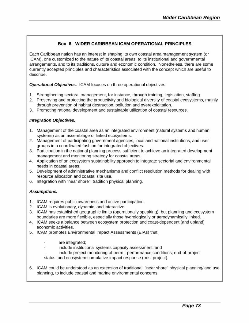
Wider Caribbean Region
Page 73
Box 6. WIDER CARIBBEAN ICAM OPERATIONAL PRINCIPLES
Each Caribbean nation has an interest in shaping its own coastal area management system (orICAM), one customized to the nature of its coastal areas, to its institutional and governmentalarrangements, and to its traditions, culture and economic condition. Nonetheless, there are somecurrently accepted principles and characteristics associated with the concept which are useful todescribe.
Operational Objectives. ICAM focuses on three operational objectives:
1. Strengthening sectoral management, for instance, through training, legislation, staffing.2. Preserving and protecting the productivity and biological diversity of coastal ecosystems, mainly
through prevention of habitat destruction, pollution and overexploitation.3. Promoting rational development and sustainable utilization of coastal resources.
Integration Objectives.
1. Management of the coastal area as an integrated environment (natural systems and humansystems) as an assemblage of linked ecosystems.
2. Management of participating government agencies, local and national institutions, and usergroups in a coordinated fashion for integrated objectives.
3. Participation in the national planning process sufficient to achieve an integrated developmentmanagement and monitoring strategy for coastal areas.
4. Application of an ecosystem sustainability approach to integrate sectorial and environmentalneeds in coastal areas.
5. Development of administrative mechanisms and conflict resolution methods for dealing withresource allocation and coastal site use.
6. Integration with "near shore", tradition physical planning.
Assumptions.
1. ICAM requires public awareness and active participation.2. ICAM is evolutionary, dynamic, and interactive.3. ICAM has established geographic limits (operationally speaking), but planning and ecosystem
boundaries are more flexible, especially those hydrologically or aerodynamically linked.4. ICAM seeks a balance between ecosystem protection and coast-dependent (and upland)
economic activities.5. ICAM promotes Environmental Impact Assessments (EIAs) that:
- are integrated; - include institutional systems capacity assessment; and - include project monitoring of permit-performance conditions; end-of-project
status, and ecosystem cumulative impact response (post project).
6. ICAM could be understood as an extension of traditional, "near shore" physical planning/land useplanning, to include coastal and marine environmental concerns.

Integrated Coastal Area Management
Page 74
4.4 Plan Implementation: Phase 4
4.4.1 Implementation of the Management Plan
The final phase of developing an ICAM programme is presented in Figure 8. On onetrack, the focus is on putting into operation the salient components of the basic planand its component and supplementary sub-plans. These include, among othercomponents and its component and supplemenatary sub-plans, zoning categoires (ifany), proposed "special areas", a monitoring plan and an evaluation plan. Thesecombine with previous and now continuing public participation, public education,training and information management plans, all developed in previous phases
Wider Caribbean Region
Page 75
Before action can be taken on the basic management plan, however, formal adoptionby government is required for the following:
o Adoption of the ICAM Plan and its policies, goals, new managementmeasures and initial projects.
o Establishment of the interagency coordinating mechanism.o Enactment, sometimes by legislation, of coastal zone management
boundaries and zoning scheme.o Approval of staffing and organizational changes that may be required.o Approval of the funding allocation for the ICAM programme.
From the very outset, the interface of the ICAM programme with other regulatory andresource management activities, and with other governmental management units at thenational and local level, will raise the issue of consistency. Improperly handled, it willgenerate controversy and place the new ICAM programme at risk of premature andhasty amendments to its programme plan. A procedure for addressing questions ofinconsistency that arise during the implementation phase, especially at the local level,needs to be established.
There could be a quasi-formal testing period, given the time usually necessary toobtain the required executive and legislative approvals. Some parts of the ICAMprogramme may start to function earlier than others. Major legislative initiatives are notalways required. In some countries, a decree or administrative rule is sufficient.
There is a longer-term consistency issue arising out of the permitting and leasingconditions established, and the fee schedules and standards put in place. This willrequire close tracking to ensure both fairness (and a public perception of fairness) thatwill best be achieved when such matters are eminently transparent and componentslike permit conditions and fee schedules are freely made available to the public andcirculated widely.
4.4.2 Administrative Elements of ICAM Implementation
(a) FINANCING
Sources of government financing with which to commence implementation, and therequirements for lending/donor agency funds to implement and sustain the ICAM planmust be identified. To the extent that funding is assured through local revenue, thereliance on external sources may be reduced, although start-up funds forimplementation may still be required. The expected cash flows from governmentsubventions, external (lending/donor) sources, and revenue generation for ICAM mustbe established before practical implementation can proceed. Supplemental non-governmental funds should also be identified.
Integrated Coastal Area Management
Page 76
Possible sources of funding for ICAM include:
- grants from national governments at all levels with responsibility for ICAM; - revenue from the approval of development applications;
- charges from the use of resources, such as water supply, sand extraction,etc.;
- fines imposed for breaches of pollution, planning and other regulationsand standards;
- taxes, such as head (visitor) taxes or direct (income) taxes; - external (loan/donor) funds; - lease payments for submerged lands rental.
(b) WORK PLAN
An work plan of implementation tasks, to be broken down in terms of ICAM tasks, theagency responsible, and the time of start-up (and, where appropriate, completion) isneeded. Activities should be sequenced to provide appropriate boundary conditions forthe achievement of subsequent steps.
Tracking and verification procedures on achievement or slippage in each area ofactivity are required to allow for timetable adjustments or for changes in approach to beintroduced. The failure to introduce such procedures may result in negative effectsthroughout implementation, especially where the completion of one task depends oninputs from other areas.
(c) TRAINING
Training should be provided for at several levels. This includes:
- policy makers in the political directorate, government ministers andcommunity leaders, to be educated to appreciate the purpose andimportance of ICAM;
- senior management in ICAM-related agencies responsible for critical orsecondary ICAM tasks, to establish the need for interagencycommunication and coordination;
- within the agency responsible for ICAM, to understand the functions ofmanagement and the importance of information exchange andcommunication;
- technical support staff, in skills for data collection and analysis, and toimprove interactions with resource users in the field;

Wider Caribbean Region
Page 77
- marine police, park/reserve rangers, and other law enforcement officers,in the special requirements for interpretation and application of theregulations and standards for ICAM.
Raising the level of awareness of the general public and user groups through educationis critical to the success of ICAM. There can be no appreciation of, or compliance with,an ICAM programme if citizens do not know it exists, or if they are unaware of itsstructure, potential benefits and infringements. User groups within the area are likely tovary widely, so that specially tailored approaches are needed to avoid feelings ofalienation and irrelevance. Target audiences who should be sensitized to ICAM duringimplementation include:
- specific user groups such as fishermen, diving and tour operators, beachvendors, researchers;
- developers, architects, engineers and planners in both the private andpublic sectors;
- residents of specific geographical units impacted by the coastal zone; - educators in the school system;
- special groups, such as community action groups, NGOs, women indevelopment groups, media reporters, and cultural and/or linguisticminorities.
(d) EVALUATION
A statutory requirement for the performance of the ICAM programme on some recurringschedule should be written into the enabling legislation. Changes in factors external tothe project, such as revisions to economic, land use, physical planning or other policiesat the national or regional level of government can influence the achievement of planobjectives. There should be provision for re-evaluation if these policy changes occur.Similarly, it is essential that ICAM programme managers use all available channels tomaintain their own inputs to revisions of higher-level government policy.
4.4.3 Intersectorial Strategies for ICAM Implementation
For ICAM implementation, the following intersectorial components should beconsidered:
o Pollution control. The adoption of specific standards at the national or regionallevel will allow for consistent application. This will require close coordinationwith existing pollution control and regulatory agencies. Sources of pollution canbe point or non-point, and sufficient regulatory authority must be vested at thelocal level to identify infringements. The standards for coastal waters adopted in

Integrated Coastal Area Management
Page 78
other regions demonstrate the potential for policy implementation on a largerscale.
o Land use planning. The implementation of policy is easier if the governmentowns and controls coastal land. If it does not, it still may be necessary toacquire it. Specific measures that can allow for government control includerestrictions on development, zoning, rights of access, natural habitat protection,limits on infrastructure development, and setbacks. This is often part of thedevelopment control process regarding private sector land use.
o Environmental assessment and audit. The potential impacts of a developmentmay need to be identified before planning approval in the coastal zone can begranted. Customarily there is one government agency in charge of serving asan impact assessment clearing house or permitting unit. ICAM liaison with thisunit is critical.
o Conservation. The creation of special management area status is a strategy thatis increasingly used to limit the degradation of, or to preserve or enhance thecoastal environment. Linkages by ICAM with national park management unitsand other custodial government activities for protected areas in the coastal zonecan open up alternative management options for ICAM programme staff.
o Training and Education. As mentioned elsewhere in this document, in theabsence of appropiate and effective legislation and enforcement mechanisms,the employment of training, educational, and awareness building activities forresource users and the general public should be considered a criticalcomponent for successful implementation of the ICAM plan.
4.4.4 Monitoring and Enforcement
Monitoring may be defined as the "watchdog" of the ICAM process, aiming to establishthe necessary flow of information on decisions, actions and investments as these relateto the implementation of ICAM. Evaluation utilizes the information generated bycontinuous monitoring and analyses of the effectiveness with which ICAM decisionshave been carried out, the efficiency of the investments undertaken, the equity in thedistribution of benefits among the various social groups of the community, and theimpacts of ICAM actions on the environment.
Monitoring can take several forms:
o Amient Conditions. Ongoing routine observations of environmental andsocio-economic parameters (sometimes called "status and trends") allowthe changing conditions of the managed area to be updated.
o Compliance or surveillance monitoring. This establishes the extent ofhuman activities in the managed area, and the infringements ofregulations or standards that may occur.
Wider Caribbean Region
Page 79
o Structure monitoring. Where investments have been made in structuralmeasures for coastal defense or shoreline stabilization, ongoingperformance monitoring should be undertaken, even if the feasibility ofthe structures has been studied previously.
o Programme monitoring. A reporting and evaluation system must beestablished to ensure that the objectives are being achieved within theimplementation schedule.
Enforcement is a sensitive area that can have major negative effects on implementationif it is not conducted in a manner that assists the maintenance of rapport betweenprogramme managers and user groups. Several levels of enforcement are possibleand perhaps should start with education and outreach before punitive or legal actionsare taken. The integration of ICAM enforcement activities with other enforcementundertakings in the country -- for example, those undertaken by wildlife and parkrangers or port authorities -- will require special attention and careful planning.

Page 80
CHAPTER 5.TOOLS AND TECHNIQUES FOR THE IMPLEMENTATION OF ICAM
Coastal area management requires that decision makers and professionals employ anumber of tools and techniques to aid in implementing a fully integrated ICAMprogramme. The application of some of these tools and techniques calls for highlyskilled, specialized teams. Most of them, however, employ methodologies which canbe essentially handled by the expertise already available in developing countries. ThisChapter identifies several broad classes of tools and techniques available to ICAMdecision makers and professionals:
- information management,
- coastal marine parks and special area management,
- environmental impact assessment,
- economic evaluation,
- control instruments for implementation, and
- risk assessment and management.
5.1 Information Management
Integrated management of coastal and marine areas requires the assembly,management, analysis and dissemination to decision makers (and their technicaladvisors) of large amounts of information about four-dimensional target areaenvironments, resources uses, pollution, and ambient conditions within giventimeframes. There is a continual problem of finding convenient ways to combine old(historical) data and new (real time) data to shed light on what is happening in the wayof status and trends within the resource base and related human use practices.
A problem facing coastal zone information management, especially when it is a newplanning and management initiative, is that the true priorities and scope of coastal zonemanagement activities are not known in advance -- the tendency is to build a systembeyond managers' needs or the ability of the organization to maintain over time. Thebiggest temptation is to collect and manage data, rather than information. Informationis data that has been processed -- hopefully by others. The following diagramillustrates the issue.
Another temptation is to collect the most accessible data regardless of its usefulness orpotential role in decision making within either planning or management functions. It isvery important to have a plan for using the data and a justification for its collection. It isalso important to address in advance data compatibilitiy with other information systems.

Wider Caribbean Region
Page 81
One of the less obvious implications of an integrated programme is that the activities ofthe programme depend on both the financial and information resources of otheragencies and programmes with an interest in the target area. It is important toreinforce this concept in the design of coastal information systems, to ensure that theintegrated coastal programme operates within and among (rather than beingsuperimposed on top of) the institutional framework of the national and regionaladministrative and political systems. Therefore, except for those issues that arespecific to coastal zone management, the programme needs to tap existingprogrammes and indicators of their impact for the bulk of its information resources.This also has important implications for data quality, discussed in section 5.1.5 below.
Additionally, regional information needs define some of the information requirementsfor coastal area management at the national and local level. These regionalprogrammes include the support to comprehensive, integrated coastal and marine

Integrated Coastal Area Management
Page 82
management activities provided by the UNEP Caribbean Environment Programme,IOCARIBE, CARICOM, UNDP, and other regional organizations. Demands from theseexternal regional and even international level organizations and programmes seekingnew data from emerging national programmes will tend to suffer also from data needinflation. This should be resisted by insisting upon negotiated quid pro quos ofinformation useful to management.
The UNEP Caribbean Environment Programme is promoting an information systemsand networking project, called CEPNET, for environmental policy makers, managersand planners in the Wider Caribbean Region. On one level, the CEP is building aregional information network, consisting of both informal communication links amongprofessionals throughout the region, and a formal telecommunications system builtaround established networks, such as Bitnet or the Internet, or a stand-alone electronicbulletin board. This dimension of the CEPNET project will be a powerful research andinformation sharing tool for ICAM planners and managers throughout the WiderCaribbean Region.
ICAM programme managers should engage in a formal process of "requirementsanalysis" with technically competent information systems professionals. The CEPNETcomponent of the Caribbean Environment Programme includes a technical analysiscomponent which should be a useful resource for participating ICAM programmemanagers who should develop a similar schedule of work to shape the architecture ofthe local information system. The requirements analysis should involve the range ofpotential users, in a facilitated group process, such as a Joint ApplicationsDevelopment (JAD) session.
Integrated coastal areas managers need to carefully consider five elements of theinformation management process. These are:
(1) scale,
(2) indicators derived from other programmes,
(3) unique coastal programme indicators,
(4) regional data and information needs, and
(5) data quality.
As used in this discussion, programmes use "indicators" to measure environmentalconditions or trends. They may be direct measures, surrogates, or subjectivecategories (e.g., best professional judgement). There is a vast literature of
Wider Caribbean Region
Page 83
environmental indicator selection technologies for programmes that have the time toconsider such issues.
There are several commonsense rules which managers should consider in developingthe internal information systems for any Caribbean coastal area managementprogramme, regardless of type. It should be clearly understood, however, thatsignificant programme strategy decisions underlie these information managementissues. Before information systems can be planned or implemented policy makers andprogramme managers, at both the Wider Caribbean Regional and also at the nationallevel, must define strategic directions and priorities for the programme.
5.1.1 Scale
National programme managers need to consider from the beginning the appropriatelevel of detail at which they need to conduct their planning and programmemanagement. This is a novel concept because we are not accustomed to thinkingabout the geographic scale of our decision-making processes. An example may behelpful:
A coastal area management programme inherited a series of digitizedmaps at a scale of 1:25,000. These maps were soon discarded,however, because the coastal area management programme neededto be able to reliably locate ground water sources (springs and wells)and surface water outlets on specific property holdings. In order todepict the small land holdings of this particular island, a map scale of1:5,000 or 1:6,000 (i.e., 1" = 500') was necessary.
- The management requirements of the programme definedproperty holdings as the lowest common denominator formanagement attention;
- The size of local land holdings and conventional standards ofmap accuracy defined the optimum scale for the programmesinformation and mapping systems.
Scale is important because the costs of building and maintaining fine scale (1:5,000)information is much greater than coarser scales (ò50,000). Until recently, the rule-of-thumb was that doubling the scale (e.g., from 1:50,000 to 1:25,000) of a mapquadrupled the cost of building and maintaining the map. Modern technologies such asSPOTTM digital satellite images and digital ortho-photography have decreased therelative costs of fine-scale coverage, but there are still major differences.
In general, integrated coastal area programmes need to be clear about whether theywill manage the coastal areas on the basis of:
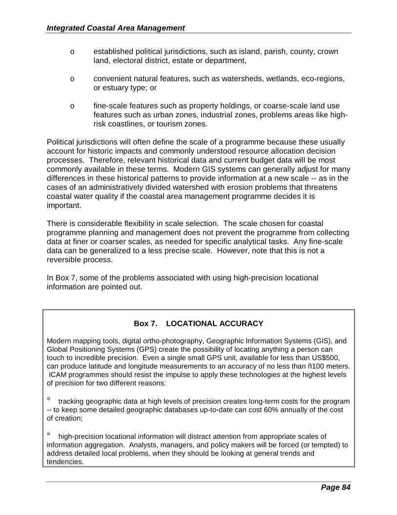
Integrated Coastal Area Management
Page 84
o established political jurisdictions, such as island, parish, county, crownland, electoral district, estate or department,
o convenient natural features, such as watersheds, wetlands, eco-regions,or estuary type; or
o fine-scale features such as property holdings, or coarse-scale land usefeatures such as urban zones, industrial zones, problems areas like high-risk coastlines, or tourism zones.
Political jurisdictions will often define the scale of a programme because these usuallyaccount for historic impacts and commonly understood resource allocation decisionprocesses. Therefore, relevant historical data and current budget data will be mostcommonly available in these terms. Modern GIS systems can generally adjust for manydifferences in these historical patterns to provide information at a new scale -- as in thecases of an administratively divided watershed with erosion problems that threatenscoastal water quality if the coastal area management programme decides it isimportant.
There is considerable flexibility in scale selection. The scale chosen for coastalprogramme planning and management does not prevent the programme from collectingdata at finer or coarser scales, as needed for specific analytical tasks. Any fine-scaledata can be generalized to a less precise scale. However, note that this is not areversible process.
In Box 7, some of the problems associated with using high-precision locationalinformation are pointed out.
Box 7. LOCATIONAL ACCURACY
Modern mapping tools, digital ortho-photography, Geographic Information Systems (GIS), andGlobal Positioning Systems (GPS) create the possibility of locating anything a person cantouch to incredible precision. Even a single small GPS unit, available for less than US$500,can produce latitude and longitude measurements to an accuracy of no less than ñ100 meters. ICAM programmes should resist the impulse to apply these technologies at the highest levelsof precision for two different reasons:
° tracking geographic data at high levels of precision creates long-term costs for the program-- to keep some detailed geographic databases up-to-date can cost 60% annually of the costof creation;
° high-precision locational information will distract attention from appropriate scales ofinformation aggregation. Analysts, managers, and policy makers will be forced (or tempted) toaddress detailed local problems, when they should be looking at general trends andtendencies.

Wider Caribbean Region
Page 85
Integrated Coastal Area Management
Page 86
5.1.2 Indicators Derived from Other Programmes
A variety of indicators from existing national and local programmes need to beincorporated in the ICAM information design. These include:
o indicators of environmental condition collected by water monitoring,wildlife, parks, agriculture, forest, fisheries, and other agencies;
o indicators of impacts on the environment, such as the numbers of boats inmajor anchorages, or the pounds of persistent pesticide applied perwatershed;
o indicators of government programme investment by programme and at thechosen level of geographic precision (e.g., port investments on a county-by-county basis);
o indicators of government programme performance by programme and atthe chosen level of geographic precision (e.g., best agriculturalmanagement practices adopted per farm by parish or watershed);
o non-critical indicators or surrogate measures of environmental conditions,including key historical trend data (e.g., volunteer counts of turtle nesting,marine bird surveys, map documentation of beach losses);
o episodic events or phenomena which may be indicative of changingenvironmental conditions, such as the cessation of demersal fishspawning activity, reef bleaching, or epidemics of porpoise or sea urchindeath;
o economic indicators of wealth, earnings, employment, public revenues,pollution costs, resource withdrawals, management costs, andinvestment;
o population and housing indicators;
o other social indicators.
To repeat the point made above, governmental or private institutions need to providethese programme indicators based on available information. If, for example, the reefdivers have never accurately tabulated fish counts by precise geographic position, thenit is the job of the coastal area management programme to persuade the divers that it isimportant for the coastal environment, and the country-at-large, to collect or retabulatethe fish count data on a more accurate basis. Similarly, if the local government doesnot separate port waste-handling from cargo-handling investments and from portaccess road projects, then the ICAM programme has to live with the inefficient
Wider Caribbean Region
Page 87
combined economic indicator, until or unless the government changes its accountingsystems. (Of course, the ICAM programme might conduct a special study todemonstrate the environmental problems caused by lumping the two types ofinvestment together, but it would not routinely fix the data from the government financeoffice or the port authority.)
The assembly and analysis of available data, and its conversion into information usefulto coastal system planners is a major task. This undertaking may take five or six years,which explains why a clear information development strategy is necessary.
Two additional points need to be made about management of information for coastaland marine resource planners.
First, it is important to focus on indicators, which are analytically calculatedducts of the source data. The ICAM programme wants to keep track ofonly indicators, not source data.
Second, the ICAM programme needs to be creative in seeking public and privatesources of relevant measures, including things such as privatelymaintained lists of real estate transactions to assess public perceptions ofenvironmental quality and amenities, fuel sales to measure someelements of economic health, or fish hook sales to measure fishingefforts.
5.1.3 Unique Coastal Programme Indicators
Historic and derived information from other programmes will not be sufficient tocharacterize all the key coastal features that the integrated coastal area managementprogramme needs to address. There will be unique values, characterized by specificenvironmental indicators, which will measure environmental conditions and tendenciesacross the entire coastal area, or in specific areas of concern. The collection andanalysis of data to support these values is the most important exception to the dictumthat the coastal area management programme should deal in information, rather thansource data.
It is beyond the scope of this framework document to describe the entire process ofenvironmental monitoring and assessment, including the development of indicators, butsuffice it to state that an ICAM programme needs to select a specific environmentalmonitoring model and adhere to it as the long-term programme measurement system.Environmental Indicators by McKenzie, et al., published by Elsevier in 1993, providesan overview of the indicator development process, which is an introduction to building areliable environmental monitoring system for coastal area programme assessment.
One model of a comprehensive environmental monitoring and assessment approach isEMAP (Environmental Monitoring and Assessment Programme), a research and
Integrated Coastal Area Management
Page 88
development activity of the US Environmental Protection Agency (EPA). The estuarineresource group of EMAP, in conjunction with the National Oceanic and AtmosphericAdministration (NOAA), has achieved significant success in designing and applyingestuarine and coastal monitoring technologies which provide statistically reliableindicators of environmental conditions with known levels of confidence over extendedgeographic areas.
Within the Wider Caribbean, the network of Biosphere Reserves (see Table 3, Section5.2) provides a variety of key environments and accessible trained managers andscientific investigators who may be prepared to test and adapt these unfamiliarenvironmental monitoring technologies to the specific conditions of the WiderCaribbean Region.
The selection of a programme monitoring strategy will determine if the integratedcoastal area management programme needs to maintain any source monitoring data. Itis preferable to piggyback new monitoring requirements on top of established collectionactivities, with the ICAM programme covering the extra costs of collection and analysis,but the field collection activity actually being carried out by an operating agency.Maintenance of a source data archive and background information about the quality ofthis data should be supervised or operated directly by the coastal area managementprogramme.
5.1.4 Regional Information Needs
The UNEP-Caribbean Environment Programme is in the process of identifying theprincipal information requirements of integrated marine and coastal area planning andmanagement processes in the Wider Caribbean Region. From these plans the region'scoastal planners will receive constructive guidance on the general directions andspecific content of regional information needs. These regional specifications shouldprovide a baseline for all of the programmes, and possibly cost-sharing mechanisms forthe data each coastal state would supply to the regional plan.
Examples of elements of the regional information strategy might include:
o agency authorities in the coastal zone;
o mapping of the coasts to specified scales, with detailed mapping for areasof special concern;
o endangered species;
o protected areas;
o coastal risks and hazards.
Wider Caribbean Region
Page 89
5.1.5 Data Quality
The Law of Coastal Data Quality: Data which are not used are perfect.
This tongue-in-cheek description of data quality summarizes many of the issues facingcoastal and marine resource managers as they attempt to build and use an informationsystem for their programme. Until managers begin to apply data to real decisions, theweaknesses of data collection and information processing procedures are not clear.Many of the data which the programme will be using to develop its systems are datawhich have never before been fully proofed or quality controlled, even though theyhave been collected for many years by other agencies.
An implication of the law of coastal data quality is that only through the use of data willwe begin to understand the limitations and problems of source data, and begin toimprove data quality. Coastal programme managers should understand that the datathey first look at is only the start in terms of quality and sufficiency. Data managementneeds to begin early in the programme planning process because (1) it takes a longtime to build the information collection system to gather information from the varioussources; and (2) it takes so long to bring data quality up to a level where managers canmake decisions with reasonable confidence.
Furthermore, building and improving the quality of data and information systems ismore a political process than a technical problem. The technical issues are usuallyrelatively straight forward. The hard part is designing a working environment in whichthe coastal resource agency and the data generating agency can collaborate openlyand freely to build a better data base. For most bureaucracies, it is threatening to learnthat much of the information being collected (and often published) is of poor quality,irrelevant or redundant.
The coastal area management agency needs to build incentives and rewards for itscooperating agencies to improve data quality, and it should be generous in giving thesource agencies credit for improved data quality. The data management processshould be planned strategically, with shared understanding among all of the partnersthat virtually all data needs to be improved, and that data linked to key resourceallocation decisions needs to be improved first.
5.1.6 Desktop Mapping and GIS Considerations
A geographic information system (GIS) is a computerized system for storing, analyzing,retrieving and displaying information in a spatial (mappable) format. Because GIScombines the power of a computerized database with the capability to view andanalyze the data in a geographic context, it is a powerful tool for coastal and marineplanning and management.

Integrated Coastal Area Management
Page 90
The use of a GIS will be a key consideration for any coastal area managementprogramme. This is an issue of considerable complexity, which can only be determinedby a combination of resources and problems faced by each programme. For thisframework, we offer only some brief thoughts about possible GIS management models. At base, good mapping is essential to planning for coastal and offshore areas, and todisplaying the results of that planning process to broader constituencies. The questionfacing an ICAM programme is how to build that mapping and analysis capability withoutdevoting an unreasonable amount of resources to mapping and GIS databasemaintenance.
Coastal planners and managers need a basic desktop mapping and analysis capability.ArcView, MapInfo, Atlas GIS, and IDRISI are four personal computer systems whichprovide this capability. MapInfo and Atlas GIS provide desktop mapping for both PCand Macintosh platforms.
GIS is, however, only a tool. A GIS will not automatically "solve" complicatedmanagement problems, nor will it produce results that are any more reliable than thedata fed into it. A well-conceived and thoughtfully implemented GIS can serve as aplatform for assembling and analyzing the information needed to make wisemanagement decisions, as illustrated in Box 8 with examples of ways in which GIS cansupport coastal management.
Not all of the potential applications in Box 8 can be met by the desktop systemsdiscussed above. The desktop systems need to be backed up by a serious GISanalysis and data management capability, probably using UNIX-based workstations.These systems should probably be based in the main governmental planning ormapping offices. This analytical support should provide the heavy-duty dataprocessing required to convert the masses of source data to summary indicators whichwill be used by ICAM programme analysts on the desktop systems. This two-tiered, orclient-server model, is similar to the approaches discussed throughout this section, inwhich the integrated coastal area management programme needs to work intimatelywith other institutions to achieve its information management goals.
Geographic information systems are not cheap. New users often are unaware that therule-of-thumb for GIS is that data acquisition costs four times as much as hardware andsoftware combined. Data maintenance is also more costly than planned in mostsystems (as much as 60% of data acquisition costs, annually).
The costs of a geographic information system may best be met by pooling theresources of various departments, agencies, and organizations interested in thesystem. Typically, cadastral agencies, utility departments, and planning offices are thefirst to realize "pay-backs" from a geographic information system, and therefore aremore inclined to invest in the technology.
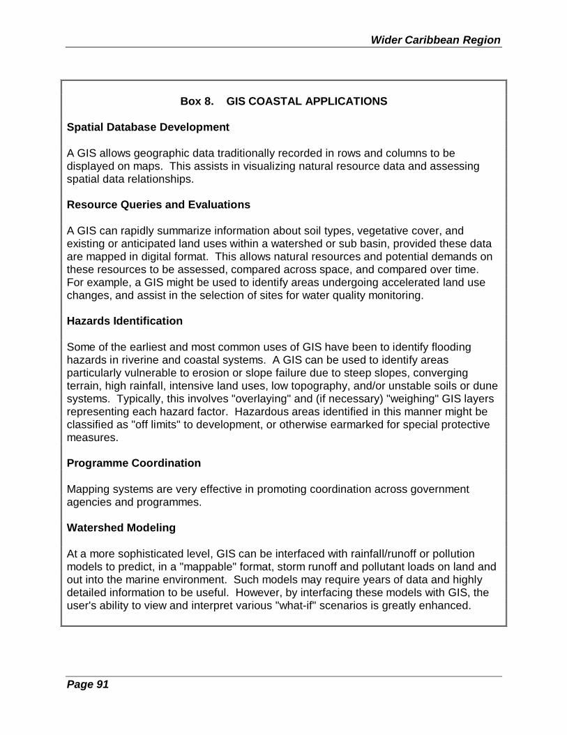
Wider Caribbean Region
Page 91
Box 8. GIS COASTAL APPLICATIONS
Spatial Database Development
A GIS allows geographic data traditionally recorded in rows and columns to bedisplayed on maps. This assists in visualizing natural resource data and assessingspatial data relationships.
Resource Queries and Evaluations
A GIS can rapidly summarize information about soil types, vegetative cover, andexisting or anticipated land uses within a watershed or sub basin, provided these dataare mapped in digital format. This allows natural resources and potential demands onthese resources to be assessed, compared across space, and compared over time.For example, a GIS might be used to identify areas undergoing accelerated land usechanges, and assist in the selection of sites for water quality monitoring.
Hazards Identification
Some of the earliest and most common uses of GIS have been to identify floodinghazards in riverine and coastal systems. A GIS can be used to identify areasparticularly vulnerable to erosion or slope failure due to steep slopes, convergingterrain, high rainfall, intensive land uses, low topography, and/or unstable soils or dunesystems. Typically, this involves "overlaying" and (if necessary) "weighing" GIS layersrepresenting each hazard factor. Hazardous areas identified in this manner might beclassified as "off limits" to development, or otherwise earmarked for special protectivemeasures.
Programme Coordination
Mapping systems are very effective in promoting coordination across governmentagencies and programmes.
Watershed Modeling
At a more sophisticated level, GIS can be interfaced with rainfall/runoff or pollutionmodels to predict, in a "mappable" format, storm runoff and pollutant loads on land andout into the marine environment. Such models may require years of data and highlydetailed information to be useful. However, by interfacing these models with GIS, theuser's ability to view and interpret various "what-if" scenarios is greatly enhanced.

Integrated Coastal Area Management
Page 92
Securing skilled staff is a special problem with new technologies such as GIS. It ishoped that regional universities and extension programmes will be offering courses inboth GIS practice and in the application of GIS concepts to natural resourcemanagement problems. Until these systems have been in place long enough to createa cadre of skilled practitioners, ICAM managers will have to seek training opportunitiesfrom the informal sector.
Three different avenues need to be pursued:
(1) There are several computer-based training systems which should beconsidered. The most elaborate is the UNITAR-sponsored tutorials forthe application of the raster-based IDRISI system. There are fourextensive manuals available for the IDRISI system, include a specialvolume devoted to Coastal Zone analysis.
(2) Short-term (e.g., one week) training programmes in the specifictechnologies being used can be effective for staff who are activelyemployed in using a GIS. Short-term training should not be used if thesystem is not up and running.
(3) Annual user group meetings (from three days to a week in length) arepresented for most of the established desktop and GIS systems. Thesesessions, and associated workshops, can be extremely productivelearning experiences, especially for staff who have worked with a specificsystem for more than six months. Staff who attend these sessions shouldbe prepped with a series of questions or problems to be adressed at themeetings.
5.2 Coastal Marine Parks and Special Area Management
There are many different reasons why an ICAM strategy sometimes is focussed not onthe entire coastal zone but on selected "special areas" for management. Regardless ofthe reason, it is a very popular approach and is sometimes even used in combinationwith a formal, more geographically extensive, country-wide approach to resourceprotection. One common example of this latter practice occurs when coastal parks andprotected areas are treated as special areas for planning and management purposeswithin national ICAM programmes.
For many states with extensive or very complex shoreline areas, establishing a nationalintegrated coastal area management programme appears both formidable and costly.Some see an advantage in a slower, more incremental approach, focusing on some setor group of "special areas" representing only a select segment of the larger coastalzone or coastline.

Wider Caribbean Region
Page 93
Sometimes, however, the compelling force for moving forward with the idea of animproved coastal management regime arises from a threat to or crisis with a specificlocation within a coastal area, for example, a flood-prone cluster of towns near anestuary or a stretch of low-lying, inhabited coastline that experiences repeated stormdamage from waves and tides. These represent special land or coastal usemanagement problems and can be classified as "critical areas of concern". Investingtime and effort in planning for such areas now may reduce damage and losses in thelonger run.
Reasons why the concept of special area management (and the antecedent planning)has proven to be a popular, almost a customizing tool of ICAM programmes are asfollows:
1. Urgency and timeliness - a specific site requires immediate attention for publichealth, economic, or political reasons, particularly in a crisis mode.
2. Instructional value - a specific site is seen as a learning vehicle or test case forICAM programme staff.
3. Incremental value - a specific site is seen as the first-stage assault on a morecomplex coastal problem.
4. Education value - a specific site is perceived as a training and education tool forICAM's larger national strategy.
5. Protection value - a decision is made to conserve an endangered site for scenic,environmental or cultural reasons.
6. Experimental value - a specific site is perceived by ICAM staff as having ademonstration value for enhancing public perceptions about the efficacy andvalue of ICAM as public policy.
7. Unique site value - especially difficult or unique features of a site or a group ofsites as a class are seen as needing the buffering or isolating effects ofprotected area status at some level (although the level may not necessarily bespecified at the outset).
8. Special problem - a site is host to a unique or especially difficult planningproblem warranting special research, analysis or control, for example, a toxicwaste site.
There is a body of experience, literature, and learned wisdom about how to undertakeeach of the above as elements of a coastal area management programme. Some havebeen completed in many locations with integrated approaches. Others have been donein a more sectorial fashion. But, taken together as a body of test approaches to real

Integrated Coastal Area Management
Page 94
issues in real time on real coastal landscapes, they are infinitely better than theory as apoint of departure.
The topical areas addressed by special area management plans within the Caribbeanare eclectic. For example:
- significant natural areas - culturally important areas - industrial areas - hazard-prone areas - economically valuable areas - unique or scenic landscapes - waterfront renewal areas - damaged ecosystems - ecotourism areas - wetland areas - estuarine areas - co-managed areas - proposed park and protected areas.
5.2.1 Parks and Protected Areas As Integral ICAM Components
Coastal and marine parks, reserves and other protected areas should form acomplementary and integral part of ICAM programmes. Such areas are a necessarycomponent of coastal resource stewardship. Some areas may be protected byeasement, by tax incentives, or by zoning. While the primary ICAM programme utilizesthe regulatory powers of government to achieve resource conservation by controllingprivate development and resolving potentially divisive conflicts among competingusers, this accomplishes only a part of the job. Additional and more focused naturalarea conservation (the custodial approach) can be accomplished by exercising theproprietary rights (rights by virtue of ownership) of government through declaration ofprotected areas -- as resource reserves, natural areas, and/or national parks -- and bythe establishment of standards for action in adjacent buffer zones.
Protected areas complement and make possible other objectives of ICAM by, forexample, conserving nursery areas for fisheries production, enhancing tourismrevenues and recreational benefits, preserving wilderness values, and promotingbaseline scientific and management studies. At the same time, protected areas gainfrom the ICAM programme important protection from external impacts. Thus, ICAM and
Wider Caribbean Region
Page 95
protected areas programmes can be mutually beneficial. Together they ensure themaintenance of a healthy resource base upon which to build sustainable development.
FAO's special guidelines for critical areas (see Clark, 1992, Section 8.2) are especiallyhelpful to an ICAM planner as they provide in detail the criteria and procedures foridentifying, ranking and selecting different classes of protected areas in order tooptimize both the biodiversity value of natural areas and their ICAM values as well.The draft guidelines∗ prepared for SPAW (Common Guidelines and Criteria to theWider Caribbean Region for the Identification, Selection, Establishment, andManagement of Protected Areas of National Interest) and IUCN's Guidelines andPrinciples for Coastal Area Development (Pernetta and Elder, 1993) are also important.
The current explosion of regional interest in marine parks is testimony to both the highpriority given to protecting marine areas and also the need to do so. The current multi-site marine park development programme of the Caribbean Conservation Association,recent marine park funding by bilateral donors, and the SPAW Regional Programme ofCEP represent important intermediate steps in the direction of an integrated regionalsystem of protected marine and coastal areas.
5.2.2 The Specially Protected Areas and Wildlife Programme (SPAW) andICAM: A Test of Complementarity
Governments of the Wider Caribbean, with the assistance of UNEP, have developedan innovative approach for the protection of coastal and marine ecosystems (includingwatersheds) through the SPAW (Special Protected Areas and Wildlife) Protocol of theCartagena Convention. The effectiveness of this new approach though will bedemonstrated by the eventual establishment of a Regional Network of CaribbeanCoastal and Marine Parks and Protected Areas.
The SPAW Protocol calls for the creation of a regional network of protected areas inorder to conserve, maintain and restore ecosystems, in particular, to maintain theecological and biological processes essential to the functioning of Wider Caribbeanecosystems. The Parties agreed specifically to protect key ecosystem components,such as coral reefs, seagrasses and mangroves.
There are three Annexes to the SPAW Protocol. Annexes I and II list the marine andcoastal flora and fauna, respectively, requiring the most protection. They includeendangered and threatened species, subspecies, and their populations. Annex Icontains a total of 57 plant species. Annex II includes all sea turtles and all marinemammals in the region. Annex III comprises 40 species of plants and 30 species ofanimals that do not need total protection but require appropriate management
∗ To be approved in October 1995 by the Interim Technical Advisory Committee ofSPAW.

Integrated Coastal Area Management
Page 96
measures. Several species that may be relatively common in certain areas wereincluded on Annex III based in part on their role as essential components of vulnerableecosystems, i.e., in providing habitat and in protecting biodiversity.
Specific objectives of the SPAW Protocol related to ICAM include:
(1) To establish a network of protected areas in the Wider Caribbean and a systemof integrated coastal marine planning. Management of a regional marine parksystem in the Wider Caribbean will provide for the monitoring, protection,restoration and ecologically sound use of the large marine ecosystem.
(2) To monitor human impacts on the heath of coastal marine ecosystems.Decision-makers will be provided with an improved basis for designing measuresthat effectively control environmental degradation.
(3) To develop Caribbean-based management expertise and public educationcampaigns. The technical capability and management expertise of localprofessionals will be improved and public participation will be encouraged toprovide the skilled manpower for nationally organized, regionally coordinatedmarine ecosystem management.
The fluid nature of coastal/marine ecosystems and the wide-ranging nature of marinespecies during various life-cycle stages make it imperative that these ecosystems beregionally managed and monitored in order to: (i) maintain the integrity of coastalecosystems in the region; (ii) ensure the propagation of ecologically important andcommercially harvestable marine and estuarine species; (iii) restore ecosystems andpopulations of depleted and endangered species; and, (iv) further develop the region'secotourism industry. The last item points to the fact that there is a clear economicbenefit to maintaining a healthy, systematically managed regional system of parks andprotected areas. For example, gross revenue generated by the Bonaire Marine Parkwas estimated at about US$25 million in 1991.
A SPAW Regional Coordinator will provide overall coordination to the system andpresumably will work jointly with ICAM leadership in each SPAW country in order toensure ecosystem-wide ecological integrity. ICAM professionals would, in turn, assistthe SPAW programme in developing a model regulatory framework to be used byparticipating states and territories and in shaping legal mechanisms and economicincentives to ensure compliance with national and regional standards and guidelines.UNEP, with IOC and IOCARIBE, would develop and institute an improved monitoringprogramme for coral reef, mangrove and seagrass ecosystems protected within theproposed Caribbean Coastal and Marine Parks and Protected Areas Network. Amonitoring programme is essential for managing marine reserve and fisheriesreplenishment areas and for safeguarding those areas designated for ecotourismsupport.
Wider Caribbean Region
Page 97
5.2.3 The Ecosystem Challenge to ICAM
One of the reasons ICAM works, wholly apart from its integrated approach, is itscapacity to zero in with an interdisciplinary approach on a specific coastal location in aproblem-solving, conflict-resolving mode, while wielding policy tools like permits,pollution loads, zoning and fee schedules to influence user practices and maintainbalance. However, this strength is also a constraint when it comes to devising newways to manage ecosystems and maintain ecosystem integrity, which require not justconsensus and balance but, in many cases, a reversal of the disturbing current processof ecosystem degradation.
There are some new lessons to be learned about the process of ecosystem restoration. The issues threatening coastal ecosystems must sooner or later drive ICAM's agenda,and policy, planning, budgeting and information systems must follow in train. ICAM'slonger-range future in the Caribbean will depend on its capacity to be responsive to thisnew ecosystem challenge -- in order to meet the larger challenge of sustainability.
The UNESCO network of ecosystem management study sites in the region (theBiosphere Reserves listed in Table 3), as well as the SPAW Programme, will providesome improved guidelines on ecosystem management and recovery. ICAM will benefitfrom these findings as will the region.
5.2.4 National Strategies for Coastal Marine Ecosystem Management
Past efforts to protect the marine and coastal environment and to manage specificnatural resources have been fragmented, often working at cross purposes. Policiesand programmes of many Caribbean governments, as well as private sectororganizations, continue to degrade ecosystems and component natural resources,despite a variety of new environmental management initiatives at all levels ofgovernment. Integrated coastal area management, while promising, is no panacea!National strategies which include integrated coastal area management programmingare quite likely to succeed more quickly than any single project.
Initiatives would be based on the following assumptions:
o Coordinated approaches to ecosystem management are necessary for bothregional agencies and national governments.
o The environmental impact assessment process encourages a broad examinationof environmental impacts not necessarily addressed by sector-specificlegislation. This integrated assessment approach is particularly well suited tosupport ecosystem management.
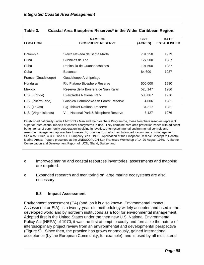
Integrated Coastal Area Management
Page 98
Table 3. Coastal Area Biosphere Reserves* in the Wider Caribbean Region.
LOCATIONNAME OF
BIOSPHERE RESERVESIZE
(ACRES)DATE
ESTABLISHED
Colombia Sierra Nevada de Santa Marta 731,250 1979
Cuba Cuchillas de Toa 127,500 1987
Cuba Peninsula de Guanahacabibes 101,500 1987
Cuba Baconao 84,600 1987
France (Guadeloupe) Guadeloupe Archipelago
Honduras Rio Platano Biosphere Reserve 500,000 1980
Mexico Reserva de la Biosfera de Sian Ka'an 528,147 1986
U.S. (Florida) Everglades National Park 585,867 1976
U.S. (Puerto Rico) Guanica Commonwealth Forest Reserve 4,006 1981
U.S. (Texas) Big Thicket National Reserve 34,217 1981
U.S. (Virgin Islands) V. I. National Park & Biosphere Reserve 6,127 1976
Established nationally under UNESCO's Man and the Biosphere Programme, these biosphere reserves representsuperior instructional models of coastal ecosystems in use. They combine core area protection zones with adjacentbuffer zones of community cooperation involving innovative, often experimental environmental controls andresource management approaches to research, monitoring, conflict resolution, education, and co-management.See also: Price, A.R.G. and S.L. Humphrey, eds., 1993. Application of the Biosphere Reserve Concept to CoastalMarine Areas: Papers presented at the UNESCO/IUCN San Francisco Workshop of 14-20 August 1989. A MarineConservation and Development Report of IUCN, Gland, Switzerland.
o Improved marine and coastal resources inventories, assessments and mappingare required.
o Expanded research and monitoring on large marine ecosystems are alsonecessary.
5.3 Impact Assessment
Environment assessment (EA) (and, as it is also known, Environmental ImpactAssessment or EIA), is a twenty-year-old methodology widely accepted and used in thedeveloped world and by northern institutions as a tool for environmental management.Adopted first in the United States under the then new U.S. National EnvironmentalPolicy Act (NEPA) of 1970, it was the first attempt to codify and formalize the nature ofinterdisciplinary project review from an environmental and developmental perspective(Figure 9). Since then, the practice has grown enormously, gained internationalacceptance (by the European Community, for example), and is used by all multilateral

Wider Caribbean Region
Page 99
assistance agencies and banks active in the Caribbean and by most bilateral donors inthe region as well.

Integrated Coastal Area Management
Page 100
EA is not as yet standard operating procedure for many of the countries in the WiderCaribbean, despite the fact that as early as 1987 the International Association forImpact Assessment held its annual meeting in Barbados with a flurry of publicity andwide regional participation at the time. The theme of the meeting was "ImpactAssessment and Development Planning". Several papers dealt with coastal andmarine issues.
Unfortunately, EAs and EIAs have not lived up to their full potential. They are criticizedas being environmentally biased and anti-development, costly, unwieldy for planningpurposes, unreadable by the public, and the cause of excessive project delays. Wheredo the faults lie? Do problems arise from the process (its structure and approach), ordo problems arise from the practitioners and their inability to use the tool properly?
The problems with EAs and EIAs fall into five categories.
1. Unsatisfactory professional and technical training and professional certificationof those using the tool.
2. The absence of a proper institutional vehicle or structure as a host or parentbody within government (often it is an add-on assignment to an existing unitwhich can result in conflicts of interest).
3. Failure to factor socio-economic impacts into the findings, into the alternativescenarios and into the decision-making process.
4. Short time frames which presents difficulty in establishing cumulativeenvironmental effects. This also limits the role of the EA process in helpingdevelopment planners evaluate project performance and test the efficacy ofprevious EA predictions regarding "project effects".
5. A lack of political will to integrate the EA into the development process.
6. The late introduction of the EA in the decision-making process -- too often theproject go-ahead is given before the EA is even started.
The provision of proper training is of paramount importance to the successfulimplementation of the EA process. Both the quantity and quality (i.e., appropriateness)of any training should be of concern. Quite possibly an "internship" or attachmenttraining may be necessary to upgrade and test the experiential side of training. Teamparticipation in truly multidisciplinary and integrated environmental and developmentplanning work is of paramount importance.

Wider Caribbean Region
Page 101
What is required is a system of post-qualification applied training (attachment trainingin the field for example) and certification and registration of EA/EIA practitioners.
Recent European Community proposals to use EAs at all levels within the developmentprocess -- policy, programme and project -- are a step in the right direction. This idea,assuming it is also tested in the Caribbean area, would greatly facilitate an ICAM/EAmarriage of convenience as overall environmental policy objectives -- for internodalferry transport planning in a port, for example -- impact long before reaching the"project" stage for the siting of an actual ferry boat terminal along the crowdedwaterfront.
This approach is known as "strategic environmental assessment" and provides theperfect methodological interface with ICAM. Both are integrative and strategic inoutlook with a dependency on good information, public participation and accurateprojections.
But it is not a perfect fit, and there are some problems. For example, the focus ofimpact assessment is on a site and the proposed project. ICAM is multi-spatial (coast,town, city, region). Impact assessment is a concentrated, discreet and intense process. ICAM is continuous. Impact assessment is a defensive maneuver, concerned withanticipating the consequences of an action (with short-term remedies). ICAM isproactive, concerned with moving toward an optimal set of conditions (with longer-termto indefinite conclusions).
How could two conceptually disparate "institutions" work together? Is there anycommon ground except the ground itself -- that is, the segment of the landscapedestined for change?
The obvious commonality is, of course, their transparent openness and holisticallyintegrative approach. Secondly, they complement each other strategically in thatimpact assessment comes into play as a management tool for ICAM in implementation,as a screening mechanism but also as an ICAM programme evaluation feedbackdevice. Conversely, impact assessment links the synoptic view of ICAM with thesectorial perspectives of the project and site.
The result is the marriage of strategic planning (ICAM) and strategic impactassessment in a truly symbiotic relationship, wherein each requires the other to performand inform, and in a repetition or continuum of the implementation cycle.
5.4 Economic Evaluation of Environmental Impacts
There is no satisfactory method to provide an economic definition (or value) forenvironmental effects. Economic effects can be identified at several different levels ofcomplexity, ranging from cash flows to life-cycle costs, national environmentalaccounts, and contingent values of environmental actions. During the early 1980s,

Integrated Coastal Area Management
Page 102
many US and international environmental groups devoted considerable resources toseveral different ways of developing national environmental accounts, or contingencyvalues for the environment. Notwithstanding the great energies which have beeninvested in the analysis of environmental values, and the rapid changes which haveoccurred in the past ten years, it is still true that there is no satisfactory way to providean economic accounting for environmental costs or benefits.
Inevitably, attempts to assign economic costs to environmental changes founder onseveral fundamental issues:
o The inexorable power of compound interest. As long as it is assumed thatan economic benefit will grow at some positive compound rate, almostany cost assigned to environmental damage can be paid for by virtue ofthe compound growth of benefits. Similarly, any combination ofenvironmental benefits can be made more attractive if the rightcombination of discount rates are used.
o Our ignorance of the true complexity of ecosystems and especiallysynergistic effects resulting from disturbances to these systems. Chaostheory and complexity concepts are the latest chimera which hold thepossibility of quantifying ecological interactions. There are two problemswith these approaches: (1) no one is close to an answer; and (2) even ifthe equations could be defined and applied perfectly, they are likely to beonly one element in the political, bureaucratic, and market processeswhich directly determine rewards and penalties in public policy makingand management of coastal and marine environments.
o The difficulty in valuing intangible environmental issues. If peopleappreciate brightly colored sunsets, should some element of air pollutionreceive a positive economic value because it creates more coloredsunsets?
Figure 10 illustrates in a conceptual way the relationship of various cost or economicvaluation systems. The diagram shows that moving outward creates a larger costdefinition which subsumes the previous definition of costs and adds additionalinformation. It should also convey the idea that the boundaries of cost elements at thehigher (outer) levels are less distinct.
5.5 Control Instruments for ICAM Implementation Processes
For each of the strategic issues identified for the integrated coastal area managementprogramme, there should be a series of problems. For each of the problems, aninstitutional inventory (see Section 4.2.4) should identify the control instrumentscurrently being employed (by which institution) to manage the specific problem. This

Wider Caribbean Region
Page 103
sub-section identifies Control Instruments actually used, but these same instrumentsneed to be assessed for their appropriate use as tools for future implementation

Integrated Coastal Area Management
Page 104
Figure 10. Conceptual illustration of the relationship of various cost or economicvaluation systems.
strategies. There are a several styles or means by which a programme can employthese instruments. Exactly how they will be employed is a function of national cultureand current institutional capacities. The most successful programmes will use multipleapproaches, carefully coordinated and focused; the least successful programmes mayhave all of the same programme features on paper and will implement them all ineptly.
For example, land-based sources of pollution are likely to be a strategic issue for mostmarine and coastal programmes. A problem contributing to land-based sources ofpollution is agricultural run-off. Table 4 illustrates how this problem might be assessedfollowing the Institutional Inventory. The entries in italics represent the priorityinitiatives which the programme might identify for future action.
(This matrix is institutionally based; in section 5.5.3, an approach based on theselection of policy instruments is presented. Planners need to consider bothapproaches.)
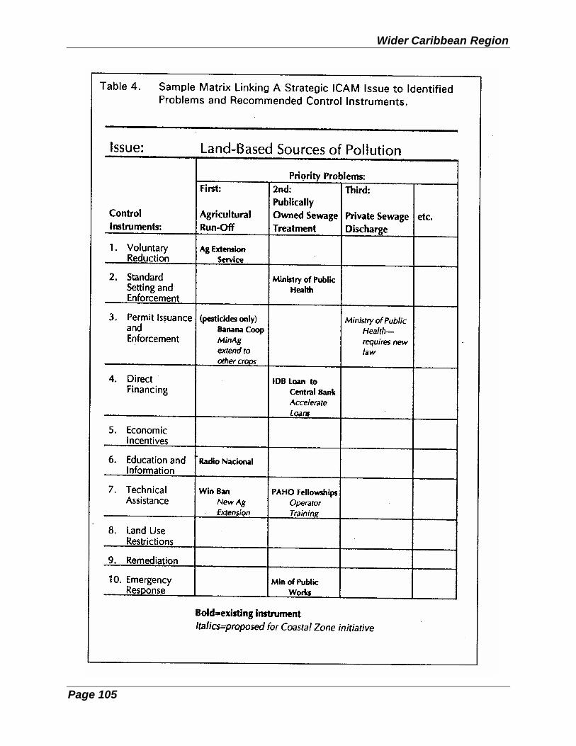
Wider Caribbean Region
Page 105

Integrated Coastal Area Management
Page 106
Ten major control instruments for institutional assessment and programmeimplementation are listed as follow:
1. Voluntary Pollutant Reductions by Source2. Standard Setting and Enforcement3. Permit Issuance and Enforcement4. Direct Financing5. Other Economic Incentives6. Education and Information7. Technical Assistance8. Land Use Restrictions9. Remediation10. Emergency Response
An alternative characterization of these tactics might address the nature of theimplementation instruments, such as
o Regulatory Instruments, and o Economic Instruments.
The following discussion is adapted from the OECD (Organization for EuropeanCooperation and Development) handbook on Coastal Zone Management: IntegratedPolicies (Cedex, Paris, 1993).
The range of instruments available for implementing environmental aspects ofdevelopment projects can be broadly classified as regulatory or economic. A thirdcategory of instruments, often used in conjunction with regulatory or economic ones, isthat of internalizing environmental awareness and responsibility into individualdecision-making by pressure or persuasion either indirectly or directly (e.g., innegotiations for voluntary agreements or covenants between industry and governmenton environmental issues). This is not an economic instrument as such but does have acharacteristic in common with economic instruments: it may be a very flexible one.
5.5.1 Regulatory Instruments
Commonly referred to as a "command and control philosophy", regulatory instrumentscan be characterized as "institutional measures (on the basis of some form oflegislation) aimed at directly influencing the environmental performance of polluters byregulating processes or products used, by abandoning or limiting the discharge ofcertain pollutants, or by restricting activities to certain limited times, etc., throughlicensing, setting of standards, zoning, etc. Their main feature is that non-complianceresults in penalties in judicial and administrative procedures.

Wider Caribbean Region
Page 107
Advantages attributed to use of direct regulations are the grip authorities have on thebehavior of actors; there is considerable experience by authorities in their operationand the rules are clear to all parties, which provides a sense of certainty.
A number of disadvantages have been identified, however. Direct regulations areincreasingly felt to be static, inflexible and sub-optimal in terms of environmental andeconomic efficiency. For example, in some instances, once a license is issued, apolluter is not encouraged to react flexibly to changed economic or technologicalconditions. This highlights the need for regulations and policies to focus on both initialcompliance and continuing compliance.
Bargaining and negotiation processes that supplement direct regulation may offer anew direction, based on mediation and arbitration experiences in the late 1980s. Theadvantages of this approach are suggested as two-fold:
o There is a higher likelihood of compliance than in the situation ofregulation without negotiation;
o It introduces flexibility to adapt to new or changed circumstances(economic, technological, social).
5.5.2 Economic Instruments
Beginning in the mid-1980s, governments in the OECD countries began to emphasizethe use of economic instruments, either alone or in conjunction with traditionalregulatory approaches. There appears to be some confusion about what to regard aseconomic instruments, due to different definitions used in different countries. Commonelements for most economic approaches to coastal and marine management include:
o Existence of financial stimuli;
o Possibility of voluntary action;
o Involvement of government (or closely related) authorities; and
o Intention of (directly or indirectly) maintaining or improving environmentalquality by applying the instrument.
The last element was brought in to distinguish between instruments that are intended tohave a direct impact on behavior, and those that are intended solely or primarily toraise funds. In practice, instruments may have a mixed character and they may beintended to have one function, but operate as the other.

Integrated Coastal Area Management
Page 108
The following groups of economic instruments are identified as effective options by theOECD:
Charges, including - User charges such as pollution fees;
- Product charges (like pollution fees, often used when volume of dischargecan be assumed to relate to total production -- flat rates can limitincentives for new product development);
- Administrative charges; - Tax differentiation (sometimes based on differential depreciation rates).
Subsidies, including: - Grants; - Soft loans; - Tax allowances and holidays.
Deposit refund systems.
Market creation, such as: - Emissions trading; - Market intervention; - Liability insurance.
(Financial) enforcement incentives broken down into: - Non-compliance fees; - Performance bonds.
Economic instruments contain a number of advantages over regulations, and offerstimuli for cleaner technologies
o They can be more cost effective by allowing the polluting activity todetermine the most appropriate ways of meeting a given standard (as inthe case of bubble offset, or trading systems) or by equating the marginalcost of treatment to the level of emissions charges across the wholerange of activities.
o They offer an ongoing incentive to reduce pollution below the levelsdetermined by regulations. They also encourage the development of newpollution control technology and non-polluting products through researchand development activities.
o They increase flexibility. For the authorities, it is often easier to modify oradjust a charge than to change legislation or regulation; for polluters, thefreedom to choose within an overall financial constraint is preserved.

Wider Caribbean Region
Page 109
o They promote resource conservation and transmission to futuregenerations in the same way that resource pricing does.
o They provide a source of finance, which may be either directed to specificenvironmental programmes or used as a significant instrument in overallfiscal policy (e.g., licensing of fishing fleets in the extended economiczones).
o Economic instruments can be explained on the basis of the politically andsocially attractive rationale that they ensure that the polluter pays.
It is acknowledged that uncertainty and lack of full information are constraints in theuse of economic instruments. The possibility that economic instruments can promoteresource conservation and that they could generate new sources of funds which mightbe used for environmental purposes make them particularly attractive for integratedcoastal area management. As different instruments can fulfill management goals todifferent degrees, it is useful to consider them in the context of specific strategies.
There are styles and fads in environmental regulation just as there are in other aspectsof public administration. Since the early-1980s, there have been many attempts tosubstitute market-based economic incentives for crude, command and control-basedregulatory regimes. More recently, there have been attempts to systematize somepositive experiences with environmental mediation and arbitration into a conflictresolution mode for environmental management.
The real lesson of these various initiatives seems to be that programmes need tocarefully choose their implementation instruments from a full pallet of options, and thatsuccess is most likely to derive from the orchestration of several instruments, based onlocal and national considerations, rather than superb use of any one tool.
5.5.3 Sample Policy Matrix
A helpful mechanism to identify the convergence of problems and policy issues forcoastal management instruments is a Policy Matrix. In such a matrix, policy elementsare matched with existing problems so that actions can be identified. Table 5 gives anexample which might be used in a large estuary.

Integrated Coastal Area Management
Page 110
Wider Caribbean Region
Page 111
5.6 Risk and Risk Assessment
The work risk unfortunately has a dual meaning -- referring usually to either theprobablility of danger or to the hazard itself. When used as "risk assessment",however, the concept customarily combines the hazard with probability as well as itsconsequences, providing a third level definition.
The four most common risks of concern within the contxt of the guidelines are resourcedepletion (e.g., mangroves and fish); habitat degradation (e.g., sewage); pollution (e.g.,toxic waste and oil spills); and natural hazards (e.g., hurricanes).
Among these risks, probablility figures customarily acquire significant public meaningonly by comparison of the risk with something else. For example:
(1) Natural backgournd levels of risk before some environmental alteration orsomestandard period.
(2) The risk of alternatives (comparing choices).
(3) Other risks in terms of probabilitly.
(4) Benefits associated with the risk (where risks are weighed against benefits or against an alternative set of risks and benefits).
Environmental risk assessment is difficult to discuss because it means two differentthings which are often confused. On the general level, environmental risk assessment(or comparative risk assessment, or ecological risk assessment) is a relatively newscientific discipline which is adapting the health risk assessment processes developedby epidemiologists and public health statisticians to the measurement of environmentaldamages, based on exposure to pollutants and toxic materials.
For ICAM planners and managers, the more familiar use of risk assessment vocabularyis in the context of natural (and sometimes manmade) disasters and their effect on theenvironment. Risk in relation to natural disasters is really a subset of the larger riskconcept, with special significance for coastal area planning and management in theWider Caribbean Region, given the area's high frequency of hurricanes, earthquakes,volcanic eruptions and tsunamis.
5.6.1 Ecological Risk Assessment and Risk Management
The success of the ecological risk assessment movement can be measured by the factthat environmental risk assessment is only two years old.
The overall risk assessment/risk management model (Figure 11) originally proposed bythe National Academy of Sciences (NAS) provided a clear separation of assessment

Integrated Coastal Area Management
Page 112
and management, and provided a general framework for developing a theory ofcomparative risk.
The four questions the National Academy suggested which need to be answered by therisk assessment process are:
Hazard Identification: Is it toxic?
Dose-Response Assessment: How toxic is it?
Exposure Assessment: Who is exposed to how much for how long and
how often?
Risk Characterization: So what?
Figure 12 shows the ecological risk assessment model now used by EPA's RiskAssessment Forum.
As scientists have gained experience with risk assessment, they have come to realizethe critical importance of maintaining an ongoing dialogue between policy makers and
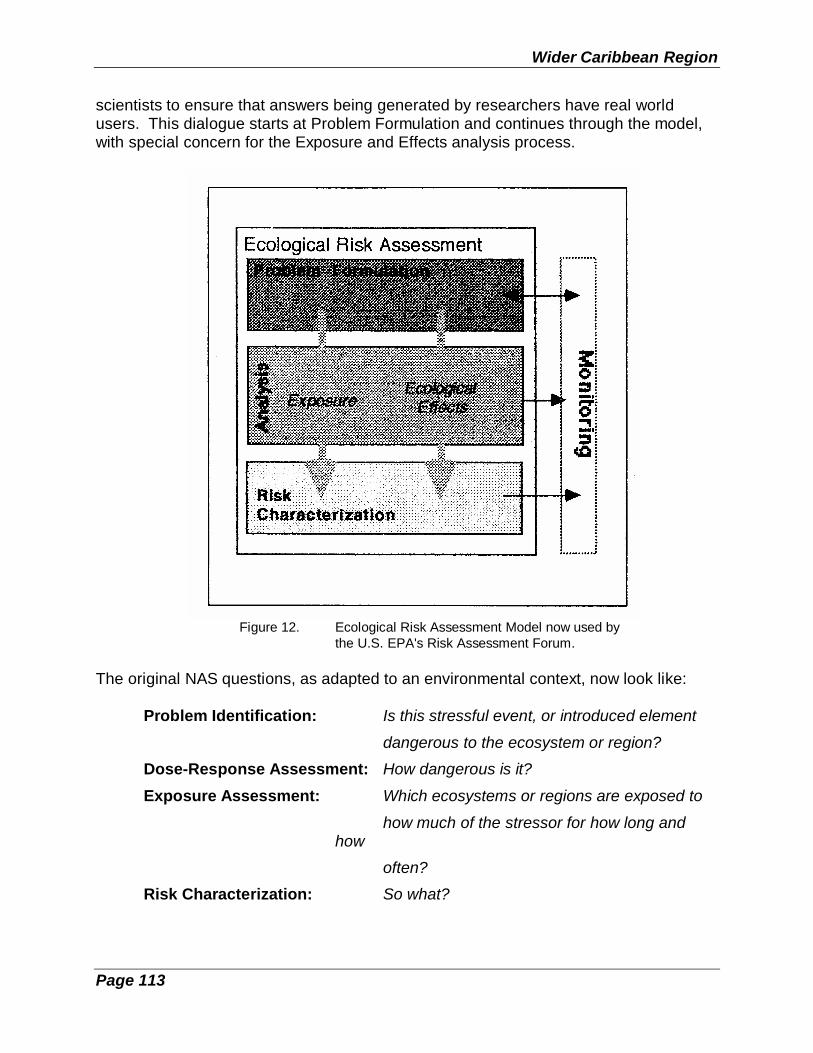
Wider Caribbean Region
Page 113
scientists to ensure that answers being generated by researchers have real worldusers. This dialogue starts at Problem Formulation and continues through the model,with special concern for the Exposure and Effects analysis process.
Figure 12. Ecological Risk Assessment Model now used bythe U.S. EPA's Risk Assessment Forum.
The original NAS questions, as adapted to an environmental context, now look like:
Problem Identification: Is this stressful event, or introduced element
dangerous to the ecosystem or region?
Dose-Response Assessment: How dangerous is it?
Exposure Assessment: Which ecosystems or regions are exposed to
how much of the stressor for how long andhow
often?
Risk Characterization: So what?
Integrated Coastal Area Management
Page 114
The objective of these risk assessment/risk management models is to generate positiveindicators of comparative risks to the environment. For example, risk assessmentresearch on the Chesapeake Bay on the eastern coast of the United States resulted ina series of pollution control activities in the following sequence:
o Reduction of toxic pollutants through point-source controls;
o Reduction in nutrients through improved publicly-owned treatment works;
o Reduction in nutrients and certain pesticides through improvedmanagement practices in the most intensively farmed portions of theBay's watershed.
Each step in this process arose from a comparative assessment of the threats andprobable returns from control actions addressing the next level of risk in the Bay'soverall condition. (The programme now faces a dilemma that the next level of riskseems to derive from air-borne pollutants, which arise from either automobile exhausts,or from major air pollutant processes far from the Bay's watershed.)
Even with less sophisticated research support, the ecological risk assessmentframework provides a systematic way to consider a variety of important influences onmarine and coastal environments. One of the limitations of ecological risk assessmentand management processes is that such planning exercises are so general inapplication that they tend to overlook the geographic nature of environmental risk. Thegeographic element is impossible to ignore in the case of disaster risk management.
5.6.2 Disaster Risk Assessment and Management
The natural environment is one of the largest losers in any natural or manmadedisaster. The Wider Caribbean Region is susceptible to a high level of risk (exposure)from a wide variety of acute natural hazards, including hurricane, earthquake, volcaniceruption, floods, debris flows, and landslides. The region is also highly susceptible tomarine oil and chemical spills from tanker collisions, given the high volumes of takertraffic in and through the region. Other serious manmade disaster possibilities includecruise ship groundings and sinkings, and chemical or refinery disasters.
The World Bank and the Department of Regional Development and Environment of theOrganization of American States have studied the economic impact of disasters. Theirstudies indicate a high benefit from public sector advance planning for disasteravoidance, mitigation, or post-disaster recovery (Table 6). These advantages must beeven higher for coastal and marine areas. For hurricanes alone, the economic costs tospecific Caribbean nations have been measured as equivalent to four months(Hurricane Gilbert in Jamaica in 1988) to five years (Hugo in Montserrat in 1989) of anisland's Gross Domestic Product (OAS, 1994.). These costs can be expected to

Wider Caribbean Region
Page 115
increase with increasing populations, tourism pressures and sea level rise from globalwarming.
Integrated Coastal Area Management
Page 116
Coastal planners have special obligations to deal with disaster risk effects, since thereare clear economic advantages from planned mitigation strategies, and becausecoastal area development is in danger of being further distorted by the reluctance of re-insurance companies to finance disaster risks in the coastal zone.In the aftermath of disasters, natural resources often are further impacted by therecovery process, unless advance planning has identified specific risks which mayexacerbate damages afflicted by the disaster itself. Major issues which need to beconsidered are:
o rapid recovery of sewage treatment and waste disposal capabilities;
o interim disposal of disaster wastes, especially activities which are likely toresult in ground water injection or crushing and filling of estuarine fringeareas such as mangroves and fringing reef areas; and
o rapid remediation actions for especially sensitive damaged resources,such as oil spills on mangroves or reefs with grounded vessels.
In Box 9, storm risk assessment in the Wider Caribbean is discussed.

Wider Caribbean Region
Page 117
Box 9. Storm Risk Assessment in the Caribbean
Two significant factors in the large losses occurring from storms in the Caribbean are
o the increasing costs of shoreline properties -- largely in response toincreased values from tourism, and
o extremely high population densities on islands affected by hurricanes(e.g., population density in North Carolina is 245 persons per square mile; the densityof Barbados is over 1550 people per square mile).
In addition, there is a suspicion, especially on the part of re-insurance companies whodetermine the costs of insurance in the region, that the frequency of storms is returningto historic levels, after having been noticeably less frequent during the 20 yearsbetween 1970 and 1990. Finally, these fears are increasing insurance rates to thepoint that development is restricted.
In light of these factors, coastal planners have a special need to provide carefulguidance on storm surges. Unfortunately, continental storm surge models are notadequate to the task on Caribbean islands.
In response to this problem, the OAS's Caribbean Disaster Mitigation Project (CDMP)has developed TAOS (The Arbiter of Storms), a computer-based model which can beemployed with a variety of GIS (Arc/INFO, IDRISI, or GRASS) to produce moreaccurate wind force estimates, storm surge heights, and wave heights at the coastline.This model produces more accurate results for island systems, and is easier to usethan alternatives, such as the WHAFIS model of the U.S. Federal EmergencyManagement Agency, and SLOSH of the U.S. National Oceanic and AtmosphericAdministration. The model uses standard "off-the-shelf" data sources, such as satelliteimagery for necessary coastal bathemetry, digital terrain data models, and U.S.National Hurricane Center databases.
(The TAOS model is more completely described in paper entitled, "New Technology for Improved StormRisk Assessment in the Caribbean," by Jan C. Vermeiren and Charles C. Watson, Jr., available from theOrganization of American States, Department of Regional Development and Environment, CaribbeanDisaster Mitigation Project, Washington, 1994.)


Page 119
CHAPTER 6. NEW CONCEPTS AND RECOMMENDATIONS
ICAM is a proven process with an unfinished agenda and an evolving list of requiredadaptations (the ecosystem challenge discussed in Section 4.2, for example). Dr. B.Cincin-Sain (1993) is perceptive when she uses the analogy of a "developing synthesismodel" to describe the current evolutionary status of ICAM. This point tends to be lessreassuring to the neophyte coastal planner (who worries more about the "changes")than to the experienced coastal expert who appreciates the flexibility of ICAM becauseit is dynamic and perpetually in a creative state of flux. New approaches andopportunities are now beginning to confirm the original assumption that ICAM is apractical and effective framework for addressing coastal resource management.
6.1 The Value of ICAM
ICAM's strategic value to national societies in the Wider Caribbean Region is as avehicle for quietly but forcefully reshaping domestic town and country and regionalsectorial planning along more holistic lines with:
(1) a stronger commitment to place;
(2) a more receptive perspective on science; and
(3) a more sensitive appreciation of an ecosystem -- natural and human; and
(4) a more dynamic planning process that incorporates an action agenda andencourages instituational innovation and integrative strategies.
This contribution to regional development is perhaps as important as ICAM'sconstructive guidance for coastal resource use in the direction of more democratic andmore sustainable kinds of development.
ICAM planning in the region, however, needs also to recognize that good planningarises from the conditions of the place, including the local environmental policyframework. Planning without a suitable supporting policy framework will, at best, fallvictim to the implication of piecemeal implementation and will fail to do justice to theplanner's vision, the supporting ecosystem, and those citizens who are its inhabitants.An improved policy framework, however, is generally predicated on an upgrade ofimplementing institutions, including NGO's.
For this reason alone, adjusting the horizons for ICAM goal setting becomes veryimportant. It is necessary to elevate its customary focus from environmental values tothe cause of operational effectiveness of governmental management processes vis avis the environment. Goals and justification would shift, therefore, fromenvironmentalism per se (as being diffuse) to the cause of moving coastal and marineissues higher on the list of priority concerns which drive public decision-making.

Integrated Coastal Area Management
Page 120
Put another way, environmental values have public value, but so do facilitating andinstitutionalizing public policy, public decisions, and public action that guarantee publicenjoyment of a clean environment, public health, and publicly-supported coastalamenities maintained for the public good.
6.2 Monitoring and Evaluation: New Approaches
The results of the ICAM programme should be subject to regular monitoring andevaluation as a way of continually improving the process. It is especially important,therefore, that the goals of the overall ICAM effort and the goals and objectives ofindividual management and/or action projects be specified as clearly and asquantitatively as possible. Otherwise assessment as to how well they are beingachieved are difficult.
The internal programme monitoring procedure should include:
(1) identification of expected performance;
(2) assessment and/or measurements of the actual performance of the programme;
(3) establishment of performance variances (e.g., shortcomings or excesses); and
(4) procedure for communicating variances that exceed pre-established limitsto the appropriate management or enforcement and implementationauthorities.
Active participation in regional monitoring initiatives supported by the CaribbeanEnvironment Programme and IOCARIBE, among others, will be important, as willarrangements for data and information exchanges among all levels of participatinginstitutions, whether international, regional, national or sub-national. (See also Section5.1 on Information Management and Section 6.3 on Science's Role in ManagingCoastal Systems.)
The recent development of customized monitoring manuals within the region on coralreef productivity and management, wetlands, mangroves, seagrasses, and sedimentreduction in coastal run-off are a good start. The process of testing existing manualsand developing additional field guides as required needs to be pursued aggressively.

Wider Caribbean Region
Page 121
Traditional project or programme evaluation is similar to a donor's "post audit". It asksquestions after the fact about how well the project went, presumably seeking to informthe next effort with lessons learned. In recent years, donors and project managershave developed an improved (normative) evaluation technique that focuses more on:
o ongoing complex projects as part of larger programmes;
o projects with many layers and levels of participation and/or institutions;and
o projects with broad social goals and specific behavioral changeobjectives.
The new evaluation process is called "strategic evaluation" because it becomes part ofthe strategy as an immediate feedback loop or mid-course correction.
Strategic evaluation embraces and blends together two proven elements long acceptedas effective:
(1) a tradition which holds that evaluation must involve the people, includingthe alleged beneficiaries and those associated with the project orprogramme under review; and
(2) the principles of "action research" evaluation which state that anyevaluation of an ongoing project will inevitably change the activity andcan make improvements by the process, thus making the evaluationprocess more than a judgmental review.
In these ways, strategic evaluation differs markedly from more traditional evaluationforms (summative or normative) and meshes well with an ICAM-type national orregional programme. Project participants (including beneficiaries) are treated asstakeholders in the pursuit of improved coastal conditions, and their collective counselis elicited regarding how the programme (or project) can be improved in the nextensuing phase. The group is also required to review its own performance. The olderand newer forms of evaluation are not mutualy exclusive, however, and can used intandem.
The strategic method used with the participant group is very similar to the GTZ "ZOPP"and the USAID "Log-Frame" in developing flip-chart-type problem trees, issue treesand action trees to achieve a degree of clarity and focus, leading to mutually plannedactions to improve working relationships and the project's momentum and impact as awhole. In this strategic evaluation format, action is inherent in the process, and theevaluator is more a process facilitator whose leadership skills must be superb but non-threatening.

Integrated Coastal Area Management
Page 122
Using this approach, an orientation toward the future and toward planning (and theinvestment of time and effort in change) is merged with evaluation's more retrospectivefocus. In this way, strategic evaluation parallels strategic planning.
6.3 Science's Role in Managing Coastal Systems
The importance of a better understanding of and predictive capability concerning thecoastal and ocean environments is critical. Chapter 17 of UNCED's Agenda 21 callsfor new approaches to "integrated management and sustainable development ofcoastal and marine areas, including exclusive economic zones". It also calls uponcountries "to cooperate in the development of necessary coastal systematicobservation, research, and information management systems". UNCED acknowledgesthat sustainable use, or integrated management, requires an information basis whichhas been obtained through the use of scientifically valid methods, and that internationalcooperation is needed to develop and integrate systematic observation programmes.
Agenda 21 also points out that national and regional capacity building are critical. Bothinternally and through international assistance programmes, mechanisms are neededto establish environmental management capabilities, including human resources.National institutions responsible for marine and coastal environmental issues, includingresearch, monitoring and management, need to be established or strengthened inmany countries. Science skills at all levels of government agencies involved withresource management will need upgrading.
6.3.1 National Needs
Our focus begins within individual countries. The ecological systems of the coastalareas of each, as well as the socio-economic development of these areas, are heavilyinfluenced by the conditions created by the proximity of the ocean. Nowhere is thismutual interdependence and influence more evident than in the coastal and nearshorezones of the tropics. Yet few countries in the Wider Caribbean Region have adequateinformation on the state of their coastal and marine resources, although suchinformation is essential for basic resource management in a sustainable mode.
Scientific input is required for essentially all aspects of integrated coastal planning andmanagement, for example:
- for mapping,
- for the establishment of baseline conditions,
- for data management,
Wider Caribbean Region
Page 123
- for the quantification of problems and their causes,
- for predictive modelling,
- for impact assessment,-
- for the formulation of mitigation measures, and
- for systematic long-term monitoring.
Unfortunately, our scientific understanding of the majority of coastal processes andsystems is far from complete.
The variety of tasks, functions and activities involved in supporting an integratedcoastal area management programme is often not appreciated and therefore comes asa surprise. Table 8 is drawn from an ongoing ICAM programme in Barbados. Itillustrates the great diversity of tasks involved in the final stages of system diagnosticsand technical studies, pilot project testing, and ICAM planning activities. It alsoillustrates the breadth of subject matter required for scientific and technical literacy inthe field of coastal resource management.
It is apparent from Table 7 that the majority of coastal zone problems are cross-sectorial and can only be solved through an interdisciplinary approach, even where oneor two sectors are the main forces driving development. Additionally, the dynamics ofcoastal oceans -- combined with the potential influence of activities within coastaldrainage basins -- means that international cooperation and coordination is required toaddress a multitude of problems which extends beyond national and even regionalboundaries.
6.3.2 Issue-based Transnational Linkages
Coastal management issues that transcend local coastal boundaries, and which musttherefore be considered in a broader context, include regional problems, such as thepollution and degradation of habitats in semi-enclosed seas like the Caribbean, or at aglobal scale, issues such as global warming and accelerated sea-level rise. There is astrong need for scientific input to address regional and global ICAM issues, which canbe simultaneously brought to bear on problems at the national or even local level. Thesupport of international and regional bodies is critical in achieving this goal --particularly where intergovernmental agreements are necessary for effective ICAM.
Linkages will emerge between national ICAM programmes and current internationalinitiatives on a wide variety of issues, for example, biodiversity conservation, marinedebris, migratory species, hazardous waste, wetlands protection, global warming, largeecosystem monitoring and research, and many other similar topics.

Integrated Coastal Area Management
Page 124
These linkages will vary widely from full support networks of kindred scholars andprofessional managers to E-mail information exchange networks to groups with acommon problem or perspective forming to lobby an international body for action orprotection, technical assistance, and even support programme funding.
Effective ICAM can be achieved through better coordination among national, regionaland international organizations and institutions. Such coordination will help to avoidunnecessary duplication, and will enable the development of the concepts, tools andnetworks that will be needed to facilitate the complex process of developing andimplementing national ICAM programmes.
There is a wide variety of international, regional, bilateral and non-governmentalorganizations with an active interest in the promotion and support of integrated coastalmanagement. In recent years, there has been a proliferation of technical assistanceprogrammes aimed at assisting coastal management programmes. This has had both

Wider Caribbean Region
Page 125
positive aspects, such as improved funding and a growing body of expertise, as well asnegative aspects, for example, competition, duplication of efforts, non-standardizedapproaches.
6.4 Coastal Landscapes: New Approaches
Coastal landscapes throughout the Wider Caribbean are mostly taken for granted butare, nonetheless, an important cultural and economic resource for any country withshoreline. They are, in one sense, an undervalued national treasure -- a blend ofnatural history and human history in action and a cultural artifact worthy ofpreservation. In the developed world, strong measures are often taken to identify,preserve and delicately exploit coastal landscape quality. The result is a plannedenvironment -- part natural and part man-made but with an appreciation for balance,beauty and sustainability. However, for the most part in the Wider Caribbean, untilnow, other priorities have prevailed, and the significance of the landscape, andseascape as well, has often been overlooked.
The attention of the conservationist has been focused elsewhere, and the prevailingphilosophy has generally been one of laissez-faire. Nevertheless, coastal landscapes -- like a good farm -- require good resource management and husbandry. A system ofbeaches or estuaries or offshore cays or coral reefs, if left alone in an unplanned,unmonitored and unmanaged state, will mostly -- save for coastal urban areas -- liefallow, harassed only by time and the occasional storm or hurricane.
For the ICAM planner/manager, addressing coastal landscapes is an exceptionallydifficult but compelling challenge for the following reasons.
1. There is no national practice, tradition or tested and proven strategy oflandscape management anywhere in the region.
2. The North American practice of relying on vast reaches of open space for the"buffering" of impacts, instead of a tight management perspective, has had anunfortunate influence on regional planners who have been trained in bothCanada and the United States.
3. Fragmented and layered sub-national state and local planning units seldomundertake landscape management initiatives at the macro scale needed. Whenlandscape/seascape planning is done, it is customized, site specific andtriggered by the client, not the vision of the planner. The exception would be theoccasionally well-planned but narrow stretch of scenic coastal highways thathave been suitably engineered for striking seascape vistas. But these areengineering not planning achievements in most cases.
4. Bilateral and multilateral donor-funded infrastructure in the region's coastalzones has universally been notably spartan and unaesthetic, lacking much

Integrated Coastal Area Management
Page 126
semblance of thoughtful planning dialogue about scenic impact mitigation oroptimum routing for other than cost factors.
One recent evaluation study from the region funded by the Canadian InternationalDevelopment Agency (CIDA) focused on a new coastal highway where the final roadrouting was done by computer on a shortest route/lowest cost, least "cut and fill" basis. This produced excessive grades and steep unstable side slopes in the deep cutswhich are prone to high erosion rates and landslide risk in an area immediatelyadjacent to the clearest water and best undeveloped beaches in the entire country. Forthe Caribbean coastal system manager, this is a classic case study in the complexitiesof balancing local landscape characteristics and ecosystem needs against donor-driven, minimum-cost project design requirements.
6.5 Programme Comparisons, Assessments and Lessons Learned
What is the best way to make use of ICAM success stories from countries and ter-ritories which have experimented with the process and have a functional programme?Researchers have devised a tentative typology characterizing how programmes differ,and a list of variables that would serve in any comparative assessment (Cicin-Sain,1993).
There is a risk, however, in jumping to conclusions about the value of comparingsuccesses and using the most successful (as opposed to the most comparable locationor country) as models. An examination of the failed aspects of partial successes withcomparability would tend to be more instructive. It is not possible to replicate anysuccessful model per se; in fact, what "worked" elsewhere has a high risk of notworking in a new location. Therefore, lessons learned from neighboring "failures" aremore likely to be truly instructive than success stories from the same neighbor.Likewise, marginal successes, and the mistakes made, from a comparable location arebetter models than the best success story from another time and differing place.The more formative approach to learning is "lesson drawing", using examples drawnfrom another time and place. As reported in Cicin-Sain (1993), these include:
(1) copying (more or less intact adoption of a programme already in effectelsewhere);
(2) emulation (adoption with adjustment for different circumstances);
(3) hybridization (combining elements of programmes from two differentplaces);
(4) synthesis (combining familiar elements from programmes in effect in 3 ormore places);
(5) inspiration (programmes elsewhere used as intellectual stimulus for de-veloping a novel programme without an analogue elsewhere.

Wider Caribbean Region
Page 127
Two more could be added:
(6) consultation (seeking counsel from someone with direct knowledge) and
(7) absorption/osmosis (employing someone who worked directly on theprevious initiative).
The assumption in the latter is that "osmotic learning" is more subtle and moreeffective. Who would know better what mistakes were made and how to avoid them?
Each generation inherits historically damaged beaches, reefs, even entire coastlines,and the present generation has made some of its inheritance worse in the rush todevelop -- oftentimes overlooking both adverse side effects and developmentalternatives. In areas of seriously damaged landscapes and seascapes, trulysustainable development requires ecosystem restoration.
The ICAM framework forces an expansion of geographical, conceptual and disciplinaryboundaries. It forces more focus on mechanisms of intervention and constructivemanagement for sustainable use, not just for one country or a piece of a shoreline butfor the region, as more than the sum of its parts -- coastal and marine from watershedto EEZ.
This regional assemblage is, of course, the same large marine ecosystem at riskreferred to in Chapter 2. These are the same marine and coastal resources thatunderpin the economies of most of the bordering states of the region. For this reason,common sense dictates that such assets warrant optimum management and protectionpractices if sustainable use is the ultimate goal. Furthermore, a custodial overview ofsystem gains and losses is important. As a routine, regional maintenance task, a"balance sheet" of system gains and losses will help define the calculus of people,place and nature -- the human ecology of the Wider Caribbean Region.
One way to ensure that this process of regional resource husbandry and "accounting"is done efficiently is for national-level resource management units to develop integratedcoastal area management programmes. UNEP's Caribbean Environment Programmecan provide a facilitating role in the Wider Caribbean Region through its RegionalProgrammes. The energizing, organizing vehicle is ICAM. The beneficiaries are thepeople, the countries, and the institutions of the Wider Caribbean Region.

Page 128
REFERENCES
This is a list of bibliography sources relevant for ICAM/Wider Caribbean whichwere either used in the text or can be rec2ommended to the users of thisdocument for reference in the implementation of ICAM in the Wider Caribbean.
Archer, A.B., 1976. Marine Pollution Off Barbados' Coasts. Prepared for Meeting of theSmaller Caribbean Islands on Oil Spill Contingency Planning, San Juan, Puerto Rico, 16-20June 1980 (Agenda Item 10). Sponsored by Organization of American States, Inter-governmental Maritime Consultative Organization, United Nations Environment Programme.
Atherley, K.A., D.A. Smith, and L.A. Nurse, 1993. "An Integrated Coastal Zone ManagementProgramme for Barbados." In: Proceedings for Coastal Zone '93:2653-2667.
Awosika, L., S. Boromthanarat, R. Comforth, M. Hendry, R. Koudstall, M. Ridgley, S.Sorenson, L. De Vrees, and S. Westmacott, 1993. Management Arrangements for theDevelopment and Implementation of Coastal Zone Management Programmes. WorldCoast Conference Organising Committee. International Conference on Coastal ZoneManagement, The Netherlands, 1-5 November 1993.
Bass, S.M.J., 1993. "Ecology and Economics in Small Islands: Constructing A Framework forSustainable Development." In: E.B. Barbier, ed., Economics and Ecology: New Frontiersand Sustainable Development. Chapman & Hall, London.
Beller, W.S., ed., 1986. Proceedings of the Interoceanic Workshop on SustainableDevelopment and Environmental Management of Small Islands, Humacao, Puerto Rico,November 3-7, 1986. U.S. Man and the Biosphere Programme, Department of State,Washington, DC.
Brower, D.J. and D.S. Carol, 1987. Managing Land-use Conflicts. Case Studies in SpecialArea Management. Duke University Press, Durham, NC. USA.
Brower, D.J., T. Beatley, and D.J.L. Blatt, 1987. Reducing Hurricane and Coastal HazardsThrough Growth Management. University of North Carolina at Chapel Hill, NC. USA.
Cambers, G., 1992. Coastal Zone Management: Case Studies from the Caribbean. LatinAmerica and the Caribbean Technical Department, Regional Studies Programme. ReportNo. 26. The World Bank.
Caribbean Community Secretariat, 1992. CARICOM Regional Environment Programme.Georgetown, Guyana.
Caribbean Conservation Association and Island Resources Foundation, 1991. Antigua andBarbuda Environmental Profile. Prepared for Government of Antigua-Barbuda and the U.S.Agency for International Development, Regional Development Office for theCaribbean/Barbados.
Caribbean Conservation Association and Island Resources Foundation, 1991. Dominica
Wider Caribbean Region
Page 129
Environmental Profile. Prepared for the Government of the Commonwealth of Dominicaand the U.S. Agency for International Development, Regional Development Office for theCaribbean/Barbados.
Caribbean Conservation Association and Island Resources Foundation, 1991. EnvironmentalAgenda for the 1990's. A Synthesis of the Eastern Caribbean Country EnvironmentalProfile Series. Prepared for U.S. Agency for International Development, RegionalDevelopment Office for the Caribbean/Barbados.
Caribbean Conservation Association and Island Resources Foundation, 1991. GrenadaEnvironmental Profile. Prepared for the Government of Grenada and the U.S. Agency forInternational Development, Regional Development Office for the Caribbean/Barbados.
Caribbean Conservation Association and Island Resources Foundation, 1991. St. Kitts andNevis Environmental Profile. Prepared for the Government of St. Kitts-Nevis and the U.S.Agency for International Development, Regional Development Office for theCaribbean/Barbados.
Caribbean Conservation Association and Island Resources Foundation, 1991. St. LuciaEnvironmental Profile. Prepared for the Government of St. Lucia and the U.S. Agency forInternational Development, Regional Development Office for the Caribbean/Barbados.
Caribbean Conservation Association and Island Resources Foundation, 1991. St. Vincent andthe Grenadines Environmental Profile. Prepared for the Government of St. Vincent and theGrenadines and the U.S. Agency for International Development, Regional DevelopmentOffice for the Caribbean/Barbados.
Cicin-Sain, B., 1982. "Management of Marine Conflicts." In: R.H. Stroud, ed., Marine Recre-ational Fisheries (pp. 127-140). International Game Fish Association, National Coalition forMarine Conservation, and Sport Fishing Institute.
Cicin-Sain, B., 1993. "Sustainable Development and Integrated Coastal Management."Ocean and Coastal Management, 21(1993):11-43. Elsevier Science Publishers Ltd.,England.
Clark, J., ed., 1985. Coastal Resources Management: Development Case Studies.Renewable Resources Information Series, Coastal Management Publication No. 3.Prepared by Research Planning Institute, Inc. Columbia, SC for U.S. National Park Serviceand U.S. Agency for International Development.
Clark, J., 1992. Integrated Management of Coastal Zones. FAO Fisheries Technical Paper327. Food and Agriculture Organization of the United Nations, Rome.
Collymore, J., F. McDonald, and H. Brown, 1993. Natural and Environmental DisasterPreparedness in the Caribbean. Background Paper for the Regional Technical Meeting onthe Sustainable Development of Small Island Developing States, Port-of-Spain, Trinidadand Tobago, July 12-16, 1993.
Coughanowr, C. and G. Kullenberg, 1993. "On the Need for Scientific Input on an

Integrated Coastal Area Management
Page 130
International Scale: The Intergovernmental Oceanographic Commission's Perspective onIntegrated Coastal Management." Ocean and Coastal Management, 21(1993):339-352.Elsevier Science Publishers Ltd., England.
Cox, J and C. Embree, eds., 1990. Sustainable Development in the Caribbean. A Report onthe Public Policy Implications of Sustainable Development in the Caribbean RegionConference, May 28-30, 1990, Kingston, Jamaica. Institute for Research on Public Policy,Halifax, NS, Canada.
Crawford, B.R., J.S. Cobb, and A. Friedman, 1993. "Building Capacity for Integrated CoastalManagement in Developing Countries." Ocean and Coastal Management, 21(1993):311-337. Elsevier Science Publishers Ltd., England.
Dalhousie Ocean Studies Programme, 1984. Development and Ocean Management in theEastern Caribbean: The Case of the Leeward Islands. Prepared as background materialfor a regional seminar held in Basseterre, St. Kitts, 7-9 June 1983, sponsored by CIDA.Dalhousie University, Halifax, NS, Canada.
Davies, J.C., V.T. Covello, and F.W. Allen, 1986. Risk Communication. Proceedings of theNational Conference on Risk Communication, held in Washington, DC, Jan. 29-31, 1986.The Conservation Foundation, Washington, DC.
de Groot, R.S., 1986. A Functional Ecosystem Evaluation Method As a Tool in EnvironmentalPlanning and Decision Making. Nature Conservation Department, Agricultural University,Wageningen, The Netherlands.
Dixon, J.A., L.F. Scura and T. van't Hof, 1992. Meeting Ecological and Economic Goals: TheCase of Marine Parks in the Caribbean. Prepared for the Second Conference on theEcology and Economics of Biodiversity Loss of the Beijer Institute, July 29-31, 1992,Stockholm, and also presented at the Second Meeting of the International Society forEcological Economics, Stockholm, August 3-6, 1992.
Gamman, J.K., 1990. A Comparative Analysis of Public Policies Affecting Natural Resourcesand the Environment: Interest Group Politics in the Eastern Caribbean. Prepared underthe DESFIL Programme of USAID by Development Alternatives, Inc., Washington, DC.
Gamman, J.K., 1990. Environmental Policy Implementation in Developing Countries. Ph.D.Dissertation, Massachusetts Institute of Technology, USA.
Goodwin, M., et al., 1985. Fishery Sector Assessment for the Eastern Caribbean:Antigua/Barbuda, Dominica, Grenada, Montserrat, St. Christopher/Nevis, St. Lucia, St.Vincent and the Grenadines. Prepared by Island Resources Foundation for USAID. St.Thomas, Virgin Islands.
Griffith, M. and J. Ashe, 1993. "Sustainable Development of Coastal and Marine Areas inSmall Island Developing States: A Basis for Integrated Coastal Management." Ocean andCoastal Management, 21(1993):269-284. Elsevier Science Publishers Ltd., England.
Godschalk, D.R., D.J. Brower, and T. Beatley, 1989. Catastrophic Coastal Storms. Hazard

Wider Caribbean Region
Page 131
Mitigation and Development Management. Duke University Press, Durham, NC. USA.
Hendry, M.D., 1993. Production of The Coastal Zone Management Plan and Phase IInvestment Project (Final). DELCAN International Ltd., Feasibility Studies in CoastalConservation. Prepared for Ministry of Housing, Lands and Environment, Government ofBarbados.
Hirvonen, H. and R.P. Cote, 1986. "Control Strategies for the Protection of the MarineEnvironment." In: Marine Policy:19-28. Butterworth & Co. (Publishers) Ltd.
Hudson, B.J., 1986. "Landscape as Resource for National Development: A Caribbean View."Geography:116-121.
Intergovernmental Oceanographic Commission, 1989. IOC-UNEP Regional Workshop toReview Priorities for Marine Pollution Monitoring, Research, Control and Abatement in theWider Caribbean. San Jose, Costa Rica, 24-30 August 1989. Workshop Report No. 59.UNESCO.
Intergovernmental Oceanographic Commission, 1993. IOC Workshop on Small IslandOceanography in Relation to Sustainable Economic Development and Coastal AreaManagement of Small Island Developing States. Fort-de-France, Martinique, 8-10November 1993. Workshop Report No. 97. UNESCO.
Intergovernmental Oceanographic Commission, Reports of Governing and Major SubsidiaryBodies, 1993. IOC Sub-commission for the Caribbean and Adjacent Regions. FourthSession, Veracruz, Mexico, 2-7 December 1992. UNESCO, IOC/SC-IOCARIBE, Paris.
Intergovernmental Oceanographic Commission, Reports of Meetings of Experts andEquivalent Bodies, 1993. IODE Group of Experts on Marine Information Management.Fourth Session, Washington, DC, USA, 6-9 October 1993. UNESCO, IOC/IODE, Paris.
Intergovernmental Oceanographic Commission, Subcommission for the Caribbean andAdjacent Regions (IOCARIBE), 1991. Global Change and Coastal Land Loss:Management and Decision-making in Support of Sustainable Development Within theCaribbean and Adjacent Regions. A Programme Proposal. IOCARIBE, Cartagena,Colombia.
Intergovernmental Oceanographic Commission/United Nations Environment Programme(IOC/UNEP), 1992. First Meeting of the CEPPOL Group of Experts, Kingston, 12-14 May1992. UNEP (OCA)/CAR WG.6/1.
Intergovernmental Oceanographic Commission/United Nations Environment Programme(IOC/UNEP), 1993. Second CEPPOL Seminar on Monitoring and Control of SanitaryQuality of Bathing and Shellfish-Growing Marine Waters in the Wider Caribbean, Kingston,Jamaica, 9-13 August 1993. CEP Technical Report No. 23. UNEP, CaribbeanEnvironment Programme, Kingston, Jamaica.
Intergovernmental Panel on Climate Change, 1994. Preparing To Meet the CoastalChallenges of the 21st Century. Conference Report of the World Coast Conference 1993,Noordwijk, The Netherlands, 1-5 November, 1993.

Integrated Coastal Area Management
Page 132
International Institute for Environment and Development, 1985. Haiti, Country EnvironmentalProfile: A Field Study. Prepared for U.S. Agency for International Development.
International Institute for Environment and Development, 1987. Jamaica CountryEnvironmental Profile. Prepared by Ralph M. Field Associates, Inc. for Government ofJamaica and the U.S. Agency for International Development.
Island Resources Foundation, 1977. Marine Environments of the Virgin Islands. TechnicalSupplement No. 1. Prepared for Virgin Islands Planning Office, Coastal Zone ManagementProgramme, St. Thomas, Virgin Islands.
Island Resources Foundation, 1993. Anguilla Environmental Profile. Prepared for theGovernment of Anguilla and the United Nations Development Programme, Barbados.
Island Resources Foundation, 1993. Montserrat Environmental Profile. Prepared for theGovernment of Montserrat and the United Nations Development Programme, Barbados.
Jernelov, A. and U. Marinov, 1990. An Approach to Environmental Impact Assessment forProjects Affecting the Marine Environment. UNEP, Regional Seas Reports and Studies,No. 122.
JRB Associates, Inc., 1981. Dominican Republic: Country Environmental Profile. A FieldStudy. Prepared for U.S. Agency for International Development.
Kelleher, G. and R. Kenchington, 1992. Guidelines for Establishing Marine Protected Areas.A Marine Conservation and Development Report. IUCN, Gland, Switzerland.
Ketchum, B.H., ed., 1972. The Water's Edge: Critical Problems of the Coastal Zone. The MITPress, Cambridge, MA, USA.
Knausenberger, W.I. and C.B. Fleming, 1989. Proceedings of the Workshop on CoastalProtected Areas in the Lesser Antilles. V.I. Cooperative Extension Service and EasternCaribbean Center, University of the Virgin Islands.
Knecht, R.W. and J. Archer, 1993. "'Integration' in the US Coastal Zone ManagementProgramme." Ocean and Coastal Management, 21(1993):183-199. Elsevier SciencePublishers Ltd., England.
Lewsey, C.D., 1990. Reassessing Policy Alternatives for Sustainable Development in CoastalAreas: Implications for the CARICOM Caribbean. Paper presented at Conference onPublic Policy Implications of Sustainable Development in the Caribbean, Kingston, Jamaica,May 28-30, 1990. Sponsored by the Government of Jamaica and the Institute for Researchon Public Policy, Ottawa, Canada.
Mattson, J.S. and J.A. DeFoor, 1985. "Natural Resource Damages: Restitution As AMechanism To Slow Destruction of Florida's Natural Resources." Journal of Land Use andEnvironmental Law, 1(3):295-319.
Wider Caribbean Region
Page 133
Maul, G.A., 1993. Ecosystem and Socioeconomic Response to Future Climatic Conditions inthe Marine and Coastal Regions of the Caribbean Sea, Gulf of Mexico, Bahamas and theNortheast Coast of South America. Caribbean Environment Programme (CEP) TechnicalReport No. 22. UNEP/CEP, Kingston, Jamaica.
McConnell, M.L. and E. Gold, 1991. "The Modern Law of the Sea: Framework for theProtection and Preservation of the Marine Environment." Journal of International Law,23(1):83-105.
McElroy, J., 1978. Economic and Social Impacts of the Virgin Islands Coastal ZoneManagement Programme. Technical Supplement No. 4. Prepared for the Virgin IslandsPlanning Office, Coastal Zone Management Programme, St. Thomas, Virgin Islands.
Natural Resources Defense Council, Inc., 1976. Who's Minding the Shore? A Citizens Guideto Coastal Management. Prepared for U.S. Department of Commerce, NOAA, OCZM,Washington, DC.
Nurse, L.A., 1990. "The Deterioration of Caribbean Coastal Zones: A Recurring Issue inRegional Development." In: J. Cox and C. Embree, eds., Sustainable Development in theCaribbean. A Report on the Public Policy Implications of Sustainable Development in theCaribbean Region Conference, May 28-30, 1990, Kingston, Jamaica. Institute for Researchon Public Policy, Halifax, NS, Canada.
Nurse, L.A., 1992. Coastal Conservation Project Unit Annual Report for the Year 1991-1992.Prepared for the Ministry of Environment, Housing and Lands, Government of Barbados.
Ogden, J.C. and E.H. Gladfelter, 1983. Coral Reefs, Seagrass Beds and Mangroves: TheirInteraction in the Coastal Zones of the Caribbean. Report of a Workshop held at WestIndies Laboratory, St. Croix, U.S. Virgin Islands, May 1982. UNESCO Reports in MarineScience No. 23. UNESCO Regional Office for Science and Technology for Latin Americaand the Caribbean, Montevideo, Uruguay.
Olsen, S.B., 1993. "Will Integrated Coastal Management Programmes Be Sustainable; theConstituency Problem." Ocean and Coastal Management, 21(1993):201-225. ElsevierScience Publishers Ltd., England.
Organisation for Economic Co-operation and Development, 1993. Coastal Zone Management: Integrated Policies. OECD, Paris, France.
Organization of American States and U.S. National Park Service, 1988. Inventory ofCaribbean Marine and Coastal Protected Areas. Department of Regional Development,OAS and Office of International Affairs, NPS, Washington, DC.
Pernetta, J. and D. Elder, 1993. Cross-sectoral, Integrated Coastal Area Planning (CICAP):Guidelines and Principles for Coastal Area Development. IUCN, Marine and Coastal AreasProgramme.
Price, A. and S. Humphrey, eds., 1993. Application of the Biosphere Reserve Concept toCoastal Marine Areas. Papers presented at the UNESCO/IUCN San Francisco Workshop

Integrated Coastal Area Management
Page 134
of 14-20 August, 1989. A Marine Conservation and Development Report of IUCN. Gland,Switzerland.
Price, A.R.G. and A.P. Heinanen, 1992. Guidelines for Developing a Coastal ZoneManagement Plan for Belize. A Marine Conservation and Development Report of IUCN.Gland Switzerland.
Ray, G.C., et al., 1981. Interim Guidelines for Identification and Selection of CoastalBiosphere Reserves. A Report to the Directorate on Biosphere Reserves. U.S. MABReport No. 6. U.S. Man and the Biosphere Programme, Department of State, Washington,DC
Richards, W.J. and J.A. Bohnsack, 1990. "The Caribbean Sea: A Large Marine Ecosystem inCrisis." In: K. Sherman, L. Alexander and B. Gold, Large Marine Ecosystems: Patterns,Processes and Yields. American Association for the Advancement of Science.
Rogers, C.S., 1985. "Toward A Lesser Antillean Biosphere Reserve." Parks, 10(3):22-24.
Rogers, C.S., 1990. "Responses of Coral Reefs and Reef Organisms to Sedimentation." In:Marine Ecology Progress Series, 62:185-202.
Rogers, C.S., et al., 1994. Coral Reef Monitoring Manual for the Caribbean and WesternAtlantic. Virgin Islands National Park, St. John, Virgin Islands.
St. Martin, K., ed., 1993. Explorations In Geographic Information Systems Technology.Volume 3. Applications in Coastal Zone Research and Management. United NationsInstitute for Training and Research, Geneva, Switzerland.
Salas, H.J., 1994. Submarine Outfalls. General Overview, Basic Design Concepts and DataRequirements for Latin America and the Caribbean. Prepared for UNEP's Second Meetingof Experts on Land-based Sources of Pollution in the Wider Caribbean Region, San Juan,Puerto Rico, 21-25 March 1994. UNEP(OCA)/CAR WG.14/INF.15.
Salm, R.V., 1984. "Ecological Boundaries for Coral-reef Reserves: Principles andGuidelines." Environmental Conservation, 11(3):209-215.
Snedaker, S.C. and C.D. Getter, 1985. Coastal Resources Management Guidelines.Renewable Resources Information Series, Coastal Management Publication No. 2.Prepared by Research Planning Institute, Inc., Columbia, SC for U.S. National Park Serviceand U.S. Agency for International Development.
Sorensen, J., 1993. "The International Proliferation of Integrated Coastal Zone ManagementEfforts." Ocean and Coastal Management, 21(1993):45-80. Elsevier Science PublishersLtd., England.
Sorensen, J.C., S.T. McCreary, and M.J. Hershman, 1984. Institutional Arrangements forManagement of Coastal Resources. Renewable Resources Information Series, CoastalManagement Publication No. 1. Prepared by Research Planning Institute, Inc., Columbia,SC for U.S. National Park Service and U.S. Agency for International Development.

Wider Caribbean Region
Page 135
Steel, J., 1993. South Atlantic and Caribbean Regional Marine Research Plan. North CarolinaState University, Raleigh, NC, USA.
Thia-Eng, C., 1993. "Essential Elements of Integrated Coastal Zone Management." Oceanand Coastal Management, 21(1993):81-108. Elsevier Science Publishers Ltd., England.
Towle, E.L. and C.S. Rogers, 1989. Case Study on the Virgin Islands Biosphere Reserve.Contribution to the UNESCO/IUCN Workshop on the Application of the Biosphere ReserveConcept to Coastal Marine Areas, San Francisco, 14-20 August 1989. Island ResourcesFoundation Occasional Paper No. 50. St. Thomas, Virgin Islands.
Towle, E.L. and R. Volk, 1994. Case Study. From Theory to Practice with Virgin IslandsCoastal Management: A Retrospective View. Prepared for InterAmerican DevelopmentBank's 5th Consultative Meeting on the Environment, "NGOs and the IDB -- A Focus onParticipation", Bridgetown, Barbados, 31 May, 1994.
United Nations Centre for Human Settlements (UNCHS) and United Nations Development Pro-gramme (UNDP), 1994. Programme for Environmentally Sustainable Land Use Planningand Settlements Development in the O.E.C.S. Bridgetown, Barbados.
United Nations Department for Development Support and Management Services, 1993.Integrated Macroeconomic Development Planning and Management for SustainableDevelopment Guidelines for Island Developing Countries. United Nations, New York.
United Nations Development Programme (UNDP), and Division for Ocean Affairs and the Lawof the Sea (DOALOS), 1994. Action Plan for Human Resources Development and CapacityBuilding for the Planning and Management of Coastal and Marine Areas, 1993-1997. FirstEdition, March 1994.
United Nations Education, Scientific and Cultural Organization (UNESCO), 1983. CoastalEcosystems of Latin America and the Caribbean. Objectives, Priorities and Activities ofUNESCO's COMAR Project for the Latin American and Caribbean Region, Caracas,Venezuela, 15-19 November 1982. UNESCO Reports in Marine Science No. 24.
United Nations Education, Scientific and Cultural Organization (UNESCO), 1994. IslandAgenda. An Overview of UNESCO's work on Island Environments, Territories andSocieties. Division of Ecological Sciences, UNESCO, Paris.
United Nations Environment Programme (UNEP), 1987. Action Plan For The CaribbeanEnvironment Programme. A Framework For Sustainable Development. UNEP CaribbeanRegional Co-ordinating Unit, Kingston, Jamaica.
United Nations Environment Programme (UNEP), 1989a. Regional Overview of EnvironmentalProblems and Priorities Affecting the Coastal and Marine Resources of the WiderCaribbean. CEP Technical Report No. 2. UNEP Caribbean Environment Programme,Kingston, Jamaica.
United Nations Environment Programme (UNEP), 1989b. Report of the Second Meeting of

Integrated Coastal Area Management
Page 136
Experts for the Development of A Protocol Concerning Specially Protected Areas andWildlife to the Convention for the Protection and Development of the Marine Environment ofthe Wider Caribbean Region. Kingston, 19-23 June 1989. UNEP(OCA)/CAR WG.3/5.
United Nations Environment Programme (UNEP), 1991. Action Plan for the Environment inLatin America and the Caribbean. UNEP, Regional Office for Latin America and theCaribbean.
United Nations Environment Programme (UNEP), 1992a. Environmental Quality Criteria forCoastal Zones in the Wider Caribbean Region. CEP Technical Report No. 14. UNEP,Caribbean Environment Programme, Kingston, Jamaica.
United Nations Environment Programme (UNEP), 1992b. Meeting of Experts on Land-BasedSources of Pollution, Veracruz, Mexico, 6-10 July 1992. UNEP (OCA)/CAR WG.9/4.
United Nations Environment Programme (UNEP), 1992c. Training in Land and Coastal UsePlanning -- Case Study Venezuela. CEP Technical Report No. 13. UNEP, CaribbeanEnvironment Programme, Kingston, Jamaica.
United Nations Environment Programme (UNEP), 1993a. Common Guidelines and Criteria tothe Wider Caribbean Region for the Identification, Selection, Establishment, andManagement of Protected Areas of National Interest. UNEP (OCA)/CAR WG.11/6. SecondMeeting of the Interim Scientific and Technical Advisory Committee (ISTAC) to the ProtocolConcerning Specially Protected Areas and Wildlife in the Wider Caribbean Region (SPAW). French Guiana, 3-5 May 1993.
United Nations Environment Programme (UNEP), 1993b. Guidelines for IntegratedManagement of Coastal and Marine Areas with Special Reference to the MediterraneanBasin. UNEP, Mediterranean Action Plan, Priority Actions Programme, Ocean and CoastalArea Programme Activity Centre.
United Nations Environment Programme (UNEP), 1993c. Report on Interregional Meeting ofExperts to Discuss Guidelines for Integrated Coastal and Marine Areas Management,Rome, 29 November-1 December, 1993. UNEP, Mediterranean Action Plan, PriorityActions Programme, Regional Activity Centre, Rome.
United Nations Environment Programme (UNEP), 1993d. Status of Implementation of theRegional Programme on Specially Protected Areas and Wildlife (SPAW). UNEP(OCA)/CAR WG.11/3. Second Meeting of the Interim Scientific and Technical AdvisoryCommittee (ISTAC) to the Protocol Concerning Specially Protected Areas and Wildlife inthe Wider Caribbean Region (SPAW). French Guiana, 3-5 May 1993.
United Nations Environment Programme (UNEP), 1994a. Draft Recommendations on APollution Prevention, Reduction and Control Strategy for LBSMP in the Wider CaribbeanRegion. Second Meeting of Experts on Land-Based Sources of Pollution in the WiderCaribbean Region, San Juan, 21-25 March, 1994. UNEP(OCA)/CAR WG.14/CRP.3.
United Nations Environment Programme (UNEP), 1994b. Regional Overview of Land-basedSources of Pollution in the Wider Caribbean Region (Revised Version). Second Meeting of
Wider Caribbean Region
Page 137
Experts on Land-based Sources of Pollution in the Wider Caribbean Region, San Juan,Puerto Rico, 21-25 March 1994. UNEP(OCA)/CAR WG.14/4.
United Nations Environment Programme/Economic Commission for Latin America and theCaribbean, 1984. The State of Marine Pollution in the Wider Caribbean Region. UNEPRegional Seas Reports and Studies No. 36. UNEP.
United Nations Food and Agriculture Organization, 1991. Living Marine Resources. ResearchPaper No. 5 prepared for the United Nations Conference on Environment andDevelopment.
United Nations Office for Ocean Affairs and the Law of the Sea, 1990. The Law of the Sea:Protection and Preservation of the Marine Environment. Repertory of InternationalAgreements Relating to Sections 5 and 6 of Part XII of the United Nations Convention onthe Law of the Sea. New York.
U.S. Agency for International Development and U.S. Department of Commerce/NOAA, 1987.Caribbean Marine Resources: Opportunities for Economic Development and Management. Washington, DC.
U.S. Man and the Biosphere Programme, 1989. Puerto Rico Workshop on Land-basedSources of Marine Pollution in the Wider Caribbean Region. August 7-9, 1989, San Juan,Puerto Rico. Caribbean Islands Directorate, OES/ENR/MAB, Department of State,Washington, DC.
U.S. National Research Council, 1994. Environmental Science in the Coastal Zone: Issues forFurther Research. Proceedings of A Retreat held at the J. Erik Jonsson Woods HoleCenter, Woods Hole, Massachusetts, June 25-26, 1992. National Academy Press,Washington, DC.
Vallega, A., 1993. "A Conceptual Approach to Integrated Coastal Management." Ocean andCoastal Management, 21(1993):149-162. Elsevier Science Publishers Ltd., England.
Vallejo, S.M., 1993. "The Integration of Coastal Zone Management into National DevelopmentPlanning." Ocean and Coastal Management, 21(1993):163-182. Elsevier SciencePublishers Ltd., England.
van der Weide, J., 1993. "A System View of Integrated Coastal Management." Ocean andCoastal Management, 21(1993):129-148. Elsevier Science Publishers Ltd., England.
Vermeiren, J.C., 1989. Natural Disasters: Linking Economics and the Environment with AVengeance. Paper prepared for Caribbean Conservation Association's Conference onEconomics and the Environment, Barbados, November 6-9, 1989.
Vermeiren, J.C. and C.C. Watson, Jr., 1994. New Technology for Improved Storm RiskAssessment in the Caribbean. OAS, Dept. of Regional Development and Environment,Washington, DC.
Williams, M.C., 1988. "Coastal Zone Management Strategies: The Caribbean Experience."In: F. Edwards, ed., Environmentally Sound Tourism in the Caribbean. The Banff Centre,
Integrated Coastal Area Management
Page 138
School of Management. University of Calgary Press.
Willms & Shier, 1992. Institutional Strengthening Project. Final Report - Stage 1. Preparedfor Coastal Conservation Project Unit, Ministry of Labour, Consumer Affairs and theEnvironment, Government of Barbados.
World Bank, 1993. Noordwijk Guidelines for Integrated Coastal Zone Management (fordistribution to the World Coast Conference 1993, Noordwijk, The Netherlands, 1-5 Nov.,1993). The World Bank, Environment Department, Land, Water and Natural HabitatsDivision, Washington, DC.
World Bank, 1994. Initiatives for Regional Action on Caribbean Environmental Issues. ReportNo. 13045-LAC. Latin America and the Caribbean Region, The World Bank, Washington,DC.

Page 139
ANNEX IGLOSSARY
Biodiversity Short for biological diversity, biodiversity refers to the variety and variabilityamong living organisms and the communities in which they live. The mostfrequent measure of diversity is a list of the species occurring within an area, butthe concept of diversity can also refer to the gene pool of a given species or tothe habitats where that species occurs.
Carrying Capacity The maximum number of users which can be sustained by a natural or man-made resource without endangering the character and quality of that resource ata sustained resource productivity over time.
Coastal The sea-land interface or a place where land, water and air meet.
Coastal Ecosystem An area that contains a set of characteristic physical, chemical and biologicalproperties; examples include mangrove forests, intertidal mud flats, salineswamps, lagoons, coral reefs, and seagrass beds. Also used to refer to anassemblage of lesser ecosystems.
Coastal Natural and man-made conditions that are either specific to the coastal zoneEnvironment (e.g., estuaries) or whose attributes are significantly determined by its location
where the land meets the sea and fresh water meets salt.
Coastal Resources A natural area or feature in or near a coastal zone, the existence of whichdepends on the coast, or the value of that resource, treated as a commodity,grows because it is located in the coastal zone, if that resource has economic,environmental, recreational, cultural, aesthetic or any other value.
Coastal Zone A geographically delineated area that is distinctively characterized by theaggregation of interacting coastal environments and corresponding natural andman-made structural systems. It is most frequently defined as land affected byits proximity to the sea and that part of the sea affected by its proximity to theland, or that area where the processes which depend on the sea-land interactionare the most intensive.
Coastal Zone Including water bodies and landforms such as islands and reefs, continentalLandforms coasts with barrier islands, beaches, cliffs, sand dunes, headlands and cliffs,
peninsulas, offshore islands, lagoons, bays, estuaries, sounds and deltas.
Coastal Zone Essentially a "production function" that combines "inputs" (labor, naturalManagement (CZM) resources, capital, time) to produce desired outputs, e.g., public beaches for
recreation, navigation facilities, a specified level of water quality, mean annualfish harvests, the preservation of a marine sanctuary, or to reduce vulnerabilityto sea level rise and other potential impacts of climate change.
Coastal Zone Designed to be the basic guide that determines how coastal resources andManagement Plan environments should be allocated among the many competing interests of
society by means of setting and establishing goals and measures.

Integrated Coastal Area Management
Page 140
Coastal Zone The core of such a program consists of the development stage for theManagement CZM plan. Surrounding the core are a number of strategies that mightProgram include other aspects such as a public participation strategy and an applied
research strategy.
Common Property Certain natural resources -- like pasture lands, forests, fisheries, wildlife,Resources reefs, beaches -- are considered to be common property resources, that is,
ownership of the resource is held in common so that the resources can beshared and jointly used.
Ecosystem A dynamic complex of plant, animal and micro-organism communities and theirnon-living environment interacting as a functional unit in a given area such aswetland communities, estuaries, and savannahs. They form the coreorganizational structures of the natural world. Ecosystems have a degree ofinherent stability which helps them to resist some disruption. Significant man-made stressors, however can alter ecosystems, affecting their ability to sustainlife, including human life.
Ecosystem Approach An analytical management approach which seeks to consider explicitly thephysical, chemical and biological interactions among the various components ofthe system in relation to natural and anthropogenic inputs to the system, andnatural and anthropogenic withdrawals and outflows from the system.
Estuary Unique waterways where fresh water drained from the land mixes with salt waterfrom the ocean. This blend of salt and fresh water makes estuaries biologicallyproductive, sustaining certain finfish, shellfish, marshes, underwater grasses,and microscopic marine life. Because of their economic, aesthetic andrecreational value, estuaries are increasingly attracting both people andcommerce to their shores.
Externality This occurs when some of the benefits or some of the costs of an action areexternal to the decision-maker's analysis, so that the welfare of one individual isinfluenced by an activity under the control of another, i.e., some of the benefitsgo to, or some of the costs are imposed upon, individuals who had no part toplay in the decision.
Geographic Computer systems for the storage, analysis, and display ofInformation System geographic information.
Greenhouse Effect The theory that continued burning of fossil fuels will increase concentrations ofcarbon dioxide in the atmosphere, thereby trapping additional heat and moisture. In time, this could create a hothouse effect, raising the temperature of the earth,causing glaciers to melt and the sea level to rise.
Habitat The sum total of environmental conditions of a specific place that is occupied byan organism, a population, or a community.
Hazardous Waste A subset of solid waste which can create a risk to the safety or health of peopleor the environment. Any solid waste which is ignitable, corrosive, reactive ortoxic and which may pose a substantial or potential hazard to human health andsafety, or to the environment when improperly managed.
Governance The composite of laws, customs and organizations and management strategies

Wider Caribbean Region
Page 141
established by society to allocate scarce resources and competing values for asocial purpose, such as to manage a nation's coastal resources andenvironment.
Integrated A dynamic process in which a coordinated strategy is developed andCoastal Zone implemented for the allocation of environmental, socio-cultural andManagement institutional resources to achieve the conservation and(ICZM) sustainable multiple use of the coastal zone.
Integrated At the operation level, integrated management refers to theManagement coordination, among all the responsible agencies, of the tasks necessary to plan
and implement activities -- like CZM activities -- including the acquisition andallocation of resources on which they depend.
Management The totality of institutional arrangements and management instrumentsArrangements available to policy and decision makers and managers in the development and
implementation of a management program.
Management Consisting of structural and regulatory measures that enable managers toInstruments achieve the goals and objectives articulated in the management plan. Structural
measures involve hard and soft structures and, when relevant, correspondingrules of operation. Regulatory instruments are measures to induce users of thecoastal resources to a desired behavior. Such measures are established by lawor other forms of "authority", such as government decrees or social traditions.
Management Part of a management plan related to specific possible actions withStrategies respect to the application of management instruments.
Non-point Source Pollutants emanating from an unconfined or unchannelled source, includingPollution agricultural runoff, drainage or seepage, and air contamination from landfills or
surface impoundments.
Planning The formulation, analysis, evaluation and adoption (selection) of a preferred setof implementation measures (strategy), and the corresponding specification ofclear verifiable goals to be achieved.
Point Source Any pollution from a confined and discrete conveyance such as a pipe, ditch,channel tunnel, well, fissure, container, rolling stock, concentrated animal-feeding operation, or vessel or other floating craft.
Pollution Charges Includes effluence charges (based on the quantity and/or quality of dischargedpollutants), product charges (charges laid upon the price of products which arepolluting in the manufacturing or consumption phases or for which a disposalsystem has been organized), user charges, administrative charges (e.g., controland authorization fees), tax differentiation.
Integrated Coastal Area Management
Page 142
Resource A conscious process of decision-making whereby natural and culturalManagement resources are allocated over time and space to optimize the attainment of stated
objectives of a society, within the framework of its technology, political andsocial institutions, and legal and administrative arrangements.
Runoff Water which, have fallen, flows across the surface of the ground picking upmaterials such as soil, agricultural chemicals and other transportable materials,continuing into a watercourse.
Sedimentation The accumulation of earthly matter (soil and mineral particles) washed into ariver or other water body (normally by erosion) which settles on the bottom.
Stakeholders Individuals, organizations, or groups with vested interests in the allocation of theresources of the coastal zone.
Sustainable A relatively new paradigm or mode of thinking that serves as a guide toDevelopment action. It entails a continuous process of decision-making in which certain
questions are asked and choices and decisions are made which aim at meetingthe needs of the present without compromising the ability of future generationsto meet their own needs. There is never an "end-state" of sustainabledevelopment since the equilibrium between development and environmentalprotection must constantly be readjusted.
Sustainable Exploitation of a resource so that it si not harvested, extracted orResource Use utilized in excess of the amount which can be regenerated. The resource is
seen as a capital investment with an annual yield; it is the yield that is utilizedand not the capital investment which is the resource base.
Water Dependent A water dependent use or activity cannot exist in any other location and isdependent on a water location by reason of the intrinsic nature of its operation.The water location or access must be needed for water-borne transportation,public access, or source of water.
Water Related A water related use or activity is not intrinsically dependent on a waterfrontlocation. A use or activity is water related if:
o It provides goods or services that are directly associated with waterdependent uses, such as supplying materials or services or using productsof water dependent uses; or
o It gains substantial cost savings or revenue-differential advantages (notassociated with land cost or rents) from being located on the waterfront thatit could not obtain from an inland location; or
o A location other than adjacent to the water would result in public loss ofquality in the goods and services offered, considering the economic, socialand environmental consequences of the use.
Wetlands Those areas that are inundated or saturated by surface or ground water at afrequency and duration sufficient to support, and that under normalcircumstances do support, a prevalence of vegetation typically adapted for life insaturated soil conditions.

Page 143
ANNEX II
INTEGRATED COASTAL AREA MANAGEMENTIN THE WIDER CARIBBEAN
A Training Programme Check List forCoastal Resource Management Professionals
I. INTRODUCTION
An increasing number of institutions, some with more experience than others, are offering coursesand workshops purporting to provide professional and technical training in the subject matter ofcoastal area resource planning and management. A few give evidence of appreciating thecomplexities of integrated coastal management and the diverse skills required in what is a trulyintersectorial, interdisciplinary field. This checklist is not a course curriculum (although it could beadapted as such); it is more an inventory of the topical issues and conceptual tools and skills thatideally need to be presented to any serious student of the subject.
II. THE TRAINING PROGRAMME: PREFERRED APPROACHES - use of in-country personnel - needs assessment and tailoring the training programme for individual/country needs - high interactive, problem-solving approach - field work - case-study/classroom work - visual aids - self-contained modules - community participation
III. TRAINING MODULES
A. The Coastal Ecosystem 1. Oceanographic Environment a. Geochemical b. Hydrological c. Estuarine interactions 2. Biological Environment a. Terrestrial b. Marine 3. Human Environment a. Population parameters b. Economy/environment interactions c. Issues of sustainability d. Institutional options and constraints
Integrated Coastal Area Management
Page 144
B. Planning and Development Control in the Coastal Zone 1. Policy/legal/institutional framework a. Taxation policy b. Sectorial policies c. Organizational 2. Resource use planning primer a. Land use capability analysis/trends b. Water use planning c. Photo interpretation and mapping 3. Development control mechanisms a. Zoning b. Environmental permitting i. Review and assessment of country planning, permitting system, institutional arrangements ii. Command-and-control regulation iii. Participatory/community-based approaches 4. Site plans: design and review 5. Environmental impact assessment 6. Impact mitigation 7. Special topics a. watershed management b. Steep-slope development c. Erosion/sediment control (BMPs) d. On-site sewage treatment systems e. On-site potable water systems f. On-site power generation g. Underground/above ground storage tanks h. Shoreline setbacks, erosion control, sand mining i. Dredging j. Marina planning k. Other land-based sources of marine pollution 8. Inspection and enforcement
C. Biodiversity Conservation/Parks and Protected Areas 1. Importance of maintaining biodiversity 2. Inventory techniques 3. Conservation area planning 4. Implementation strategies 5. Complementary objectives: park system planning 6. Wildlife management 7. Fisheries management 8. Protected area planning for historic/cultural sites in the coastal zone
D. Wetlands Management 1. Definition and components of a wetland ecosystem a. Hydrology b. Hydric soils c. Hydrophytic vegetation d. Mangrove/seagrass/coral reef interactions 2. Inventory techniques 3. Developing a management framework

Wider Caribbean Region
Page 145
4. Implementation strategies a. Policy framework b. Legislative framework c. Technical needs d. Development control framework 5. Monitoring techniques
E. Water Quality Monitoring and Assessment 1. Goals: maintaining designated use 2. Water quality standards 3. Parameters 4. Monitoring techniques
F. ACHIEVING SUSTAINABILITY 1. Natural Hazard Mitigation a. Landslide hazard mitigation b. Coastal storm hazard mitigation c. Floodplain management 2. Pre-/post-disaster assessment 3. Long-term ecological monitoring a. Coral reefs b. Seagrass c. Mangroves d. Salt ponds, wetlands, estuaries e. EEZs f. Watersheds g. Beaches and dunes 4. Conflict resolution/co-management 5. Information systems management a. GIS b. Cartographic capability c. Library/documentation systems d. Information exchange 6. Solid waste/landfill management a. Design, construction, operation, closure b. Site assessment/selection c. Waste stream minimization d. Recycling 7. Programme evaluation
______________________________________