guidelines for describing associations and alliances …vegbank.org › vegdocs › panel ›...
TRANSCRIPT

GUIDELINES FOR DESCRIBING ASSOCIATIONS AND ALLIANCES OF THE U.S. NATIONAL VEGETATION
CLASSIFICATION
Michael Jennings1*, Don Faber-Langendoen2, Robert Peet3, Orie Loucks4, David Glenn-Lewin5, Antoni Damman6, Michael Barbour7, Robert Pfister8, Dennis Grossman2, David Roberts9,
David Tart10, Marilyn Walker10, Stephen Talbot11, Joan Walker10, Gary Hartshorn12, Gary Waggoner1, Marc Abrams13, Alison Hill10, Marcel Rejmanek7
The Ecological Society of America Vegetation Classification Panel
Version 4.0 July, 2004
1. U.S. Geological Survey, 2. NatureServe, 3. University of North Carolina, 4. Miami University, 5. Unity College, 6. Kansas State University, 7. University of California-Davis, 8. University of Montana, 9. Montana State University, 10. USDA Forest Service, 11. U.S. Fish and Wildlife Service, 12. World Forestry Center, 13. Pennsylvania State University,
* Manuscript contact: email [email protected]; phone 208-885-3901
The Ecological Society of America, Vegetation Classification Panel
1
ABSTRACT 1
The purpose of this document is to provide guidelines for describing and classifying plant 2
associations and alliances as formally recognized units of vegetation within the U.S. National 3
Vegetation Classification (NVC), a regional component of the International Vegetation 4
Classification (NatureServe 2003). The guidelines are intended to be used by anyone proposing 5
additions, deletions, or other changes to the named units of the NVC. By setting forth guidelines 6
for field records, analysis, description, peer review, archiving, and dissemination, the Ecological 7
Society of America’s Vegetation Classification Panel, in collaboration with the U.S. Federal 8
Geographic Data Committee, NatureServe, the U.S. Geological Survey, and others, seeks to 9
advance our common understanding of vegetation and improve our capability to sustain this 10
resource. 11
We begin by articulating the rationale for developing these guidelines and then briefly 12
review the history and development of vegetation classification in the United States. The 13
guidelines for floristic units of vegetation include definitions of the association and alliance 14
concepts. This is followed by a description of the requirements for field plot records and the 15
identification and classification of vegetation types. Guidelines for peer review of proposed 16
additions and revisions of types are provided, as is a structure for data access and management. 17
Since new knowledge and insight will inevitably lead to the need for improvements to the 18
guidelines described here, this document has been written with the expectation that it will be 19
revised with new versions produced as needed. Recommendations for revisions should be 20
addressed to the Panel Chair, Vegetation Classification Panel, Ecological Society of America, 21
Suite 400, 735 H St, NW, Washington, DC. Email contact information can be found at 22
http://www.esa.org/vegweb or contact the Ecological Society of America’s Science Program 23
Office, 1707 H St, NW, Suite 400, Washington, DC 20006, Telephone: (202) 833-8773. The 24
authors of this document work as volunteers in the service of the Ecological Society of America 25
and the professional opinions expressed by them in this document are not necessarily those of 26
the institutions that employ them. 27

Guidelines for Describing Associations and Alliances of the U.S. NVC, Version 3.0
2
TABLE OF CONTENTS 28
ABSTRACT.................................................................................................................................... 1 29
INTRODUCTION .......................................................................................................................... 3 30 1. RATIONALE............................................................................................................................ 3 31 2. BACKGROUND AND PRINCIPLES ..................................................................................... 5 32
2.1 DISCLAIMERS............................................................................................................... 7 33 3. A BRIEF HISTORICAL BACKGROUND ............................................................................. 8 34
3.1. DESCRIBING AND CLASSIFYING VEGETATION .................................................. 9 35 3.2. A NATIONAL VEGETATION CLASSIFICATION FOR THE UNITED STATES .. 18 36
ESTABLISHING AND REVISING FLORISTIC UNITS OF VEGETATION .......................... 21 37 4. THE ASSOCIATION AND ALLIANCE CONCEPTS ......................................................... 22 38
4.1. ASSOCIATION............................................................................................................. 22 39 4.2 ALLIANCE.................................................................................................................... 25 40
5. VEGETATION FIELD PLOTS ............................................................................................. 27 41 5.1. MAJOR TYPES OF REQUIRED DATA ..................................................................... 27 42 5.2. STAND SELECTION AND PLOT DESIGN ............................................................... 28 43 5.3 PLOT DATA ................................................................................................................. 34 44
6. CLASSIFICATION AND DESCRIPTION OF FLORISTIC UNITS ................................... 46 45 6.1. FROM PLANNING TO DATA INTERPRETATION ................................................. 46 46 6.2. DOCUMENTATION AND DESCRIPTION OF TYPES............................................. 51 47 6.3. NOMENCLATURE OF ASSOCIATIONS AND ALLIANCES................................. 54 48
7. PEER REVIEW ...................................................................................................................... 58 49 7.1 CLASSIFICATION CONFIDENCE............................................................................. 59 50 7.2. PEER-REVIEW PROCESS........................................................................................... 61 51
8. DATA ACCESS AND MANAGEMENT.............................................................................. 64 52 8.1 BOTANICAL NOMENCLATURE .............................................................................. 64 53 8.2 PLOT DATA ARCHIVES AND DATA EXCHANGE................................................ 66 54 8.3 COMMUNITY-TYPE DATABASES........................................................................... 67 55 8.4 PROPOSAL SUBMISSION AND THE NVC PROCEEDINGS.................................. 68 56
9. DEFINTIONS AND GUIDELINES FOR FIELD APPLICATIONS .................................... 68 57 9.1 DEFINITIONS AND CRITERIA FOR FLORISTIC UNITS....................................... 69 58 9.2 COLLECTING FIELD PLOTS..................................................................................... 70 59 9.3. CLASSIFYING AND DESCRIBING ASSOCIATIONS AND ALLIANCES ............ 75 60 9.4 PEER REVIEW OF PROPOSED VEGETATION TYPES .......................................... 79 61 9.5. MANAGEMENT OF VEGETATION DATA.............................................................. 82 62
LOOKING AHEAD ..................................................................................................................... 84 63 10. INTERNATIONAL COLLABORATION, PROSPECTS AND DIRECTIONS................... 84 64
10.1 INTERNATIONAL COLLABORATION .................................................................... 84 65 10.2 BUILDING THE CLASSIFICATION CONSORTIUM FOR THE FUTURE............. 85 66 10.3 PROSPECTS FOR SCIENTIFIC ADVANCEMENT .................................................. 86 67

The Ecological Society of America, Vegetation Classification Panel
3
ACKNOWLEDGMENTS ............................................................................................................ 88 68
LITERATURE CITED ................................................................................................................. 89 69
GLOSSARY ............................................................................................................................... 101 70
APPENDIX 1.............................................................................................................................. 107 71
APPENDIX 2.............................................................................................................................. 124 72
APPENDIX 3.............................................................................................................................. 137 73
APPENDIX 4.............................................................................................................................. 147 74
TABLES ..................................................................................................................................... 148 75
FIGURES.................................................................................................................................... 157 76
TEXT BOXES ............................................................................................................................ 162 77
78
INTRODUCTION 79
1. RATIONALE 80
A standardized, widely accepted vegetation classification for the United States is required 81
for effective inventory, assessment, and management of the nation's ecosystems. These needs 82
are increasingly apparent as individuals, private organizations, and governments grapple with the 83
escalating alteration and loss of natural vegetation (for examples, see Klopatek et al. 1979, Mack 84
1986, LaRoe et al. 1995, Mac 1999). Remnants of natural vegetation have become increasingly 85
rare (Noss et al. 1995, Noss and Peters 1995, Barbour and Billings 2000). Some types are now 86
imperiled because of habitat loss or degradation, and others have disappeared entirely from the 87
landscape without ever having been formally documented (Grossman et al. 1994). Losses of 88
vegetation types represent losses in habitat diversity, leading directly to more species1 being in 89
danger of extinction (Ehrlich 1997, Wilcove et al. 1998, Naeem et al. 1999). Predicted changes 90
in climate, continued atmospheric pollution, ongoing invasions by exotic organisms, and land 91
use changes are likely to cause further unprecedented and rapid alteration in vegetation 92
(Overpeck et al. 1991, Vitousek et al. 1997, Morse et al. 1995), possibly altering existing land 93
1. Species: technically we typically mean both species and subspecies, and occasionally genera. The term
“taxa” is the technical term for these and all other taxonomic entities. However, our focus is at the species and subspecies level and we use species as a common shorthand term for the object of our focus.

Guidelines for Describing Associations and Alliances of the U.S. NVC, Version 3.0
4
uses and local economies over large areas. Widespread changes in land use have led to 94
increased social and economic conflicts, resulting in an increasing demand for more robust and 95
timely information about remaining natural and seminatural environments. In addition to these 96
environmental issues, a standardized classification is needed to place basic ecological and 97
biodiversity studies in context. In its application to mapping vegetation, a standardized 98
classification can form the basis for consistently defined and comparable units among different 99
maps. We expect that this standardized classification will play a prominent role in guiding 100
research, resource conservation, and ecosystem management, as well as in planning, restoration 101
activities, and in predicting ecosystem responses to environmental change. 102
To meet the need for a credible, broadly-accepted vegetation classification, the 103
Ecological Society of America (ESA: the professional organization for ecologists in the United 104
States) joined with cooperating organizations such as the U.S. Geological Survey, U.S. Federal 105
Geographic Data Committee, and NatureServe2 to form a Panel on Vegetation Classification. To 106
formalize this partnership, the four participating organizations signed a formal Memorandum of 107
Understanding (MOU)3 in August 1998. This MOU defines the working relationship among the 108
signers for the purpose of advancing the National Vegetation Classification. 109
The objectives of the ESA Vegetation Classification Panel are to: (1) facilitate and 110
support the development, implementation, and use of a standardized vegetation classification for 111
the United States; (2) guide professional ecologists in defining and adopting standards for 112
vegetation sampling and analysis in support of the classification; (3) maintain scientific 113
credibility of the classification through peer review; and (4) promote and facilitate international 114
collaboration in development of vegetation classifications and associated standards. In this 115
document the Panel articulates and explains a set of standards and procedures aimed at achieving 116
the first three of these objectives. 117
2. In July of 2000 The Nature Conservancy’s science staff that helped to develop the U.S. National
Vegetation Classification transferred to a new organization, NatureServe, which now represents the interests of the Conservancy in the ongoing development of the NVC.
3. Forming a partnership to further develop and implement the national vegetation classification standards. Memorandum of Understanding among ESA, TNC (NatureServe), USGS, and FGDC. 1999. Ecological Society of America, Washington, D.C., USA. 6p. (http://www.esa.org/vegweb/#MOU).

The Ecological Society of America, Vegetation Classification Panel
5
2. BACKGROUND AND PRINCIPLES 118
The ESA Panel on Vegetation Classification recognizes the Federal Geographic Data 119
Committee’s (FGDC) “National Vegetation Classification Standard” (1997) as the starting point 120
for developing a national vegetation classification. The FGDC classification standard is a 121
physiognomic-floristic hierarchy with higher-level physiognomic units and lower-level floristic 122
units (Figure 1). The FGDC standard, based on the International Classification of Ecological 123
Communities or ICEC (Grossman et al. 1998; now referred to as the International Vegetation 124
Classification, or IVC), introduced the classification hierarchy, documented the component 125
elements of all except the floristic levels, and provided the context for defining those floristic 126
levels. Between 1995 and 1996 the Panel concentrated on assisting the FGDC by reviewing 127
proposed standards for the physiognomic categories (class, subclass, group, subgroup, and 128
formation; Loucks 1996), as well as the specific physiognomic types within these categories. 129
The guiding principles established by the FGDC for the overall development of the NVC 130
are shown in Box 1 (FGDC 1997, Section 5.3). In particular, the 1997 FGDC standard provided 131
definitions for the floristic units of the classification: the alliance and association. These 132
definitions begin with the premise that a vegetation type represents a group of stands that have 133
similar plant composition and physiognomy, and that types must have diagnostic criteria to 134
enable their recognition. Nonetheless, we recognize that, due to complex biophysical factors as 135
well as chance, vegetation is a continuously varying phenomenon and that species are, to some 136
extent, stochastic in their distribution. As a consequence, floristic vegetation units are not readily 137
defined by precise and absolute criteria. Instead, some examples of vegetation can be seen to be 138
unambiguously members of a particular type, whereas others are intermediate such that their 139
assignment must be defined in terms of relative affinities with alternative types. 140
Although the 1997 FGDC standard includes the two floristic categories of the NVC 141
hierarchy, Alliance and Association, it provides no list of recognized types, no details about 142
nomenclature, nor methods for defining and describing alliances and associations. With respect 143
to these categories, the document states “The current list of Alliances and Associations for the 144
conterminous United States will be published by The Nature Conservancy in the spring of 145
1997.” (FGDC 1997 Section 6.0). The list was published in 1998, in cooperation with the 146
Natural Heritage Network (Anderson et al. 1998) and has subsequently been repeatedly refined 147
Guidelines for Describing Associations and Alliances of the U.S. NVC, Version 3.0
6
and improved. Each alliance and association on the list is described in a standardized format 148
(see Grossman et al. 1998, page 48) that contains a compilation of literature and field 149
observations. Collectively, these descriptions constitute a comprehensive summary of our 150
knowledge of the plant communities of the United States. The Panel anticipates that the 151
recognized list of type descriptions will be enhanced and revised in accordance with the FGDC 152
requirement that the alliance and association types must be based on field data conforming to 153
standard methods (FGDC 1997, Sections 5.3 and 7.1) and that the types will be defined so as to 154
meet standard criteria for acceptance. However, the precise standards and criteria were not 155
spelled out by the FGDC. The standards presented here are intended to meet that need. 156
We have used the FGDC “Guiding Principles” and the definitions for association and 157
alliance to guide the development of standards for defining, naming, and describing floristic 158
units. Our goal for future revisions of the list of alliances and associations and supporting 159
documentation is that they will be based on standardized field observation, type description, 160
peer-review, and data management. Each of these activities is summarized next. 161
Field plot records. Vegetation associations and alliances should be identified and 162
described through numerical analysis of plot data that have been collected from across the range 163
of the vegetation type and closely related types (irrespective of political and jurisdictional 164
borders). We outline standards for plot data in Section 5. 165
Type description. Proposals for new or revised floristic units must adhere to standards 166
for circumscribing and describing types. Each type description should include sufficient 167
information to determine the distinctive vegetation features of the type and its relation to other 168
types recognized in the classification. Proposals for revision of recognized types must include 169
comparison of the focal types with related types of that level to ensure that they do not duplicate 170
or significantly overlap, but rather enhance, replace, or add to them. We outline standards for 171
type circumscription and description in Section 6. 172
Peer review. Proposals for new and revised types need to be evaluated through a 173
credible, open peer-review process. Standards for the peer-review process are outlined in 174
Section 7. 175
Data management. Plot data used to define and describe an association or alliance must 176
be permanently archived in a publicly accessible data archive, either for revisions to the 177
descriptions of existing type concepts, new descriptions of proposed types, or other uses. A 178
The Ecological Society of America, Vegetation Classification Panel
7
digital schema for sharing and integrating plot data from multisource heterogeneous data sets is 179
vitally important to the development of a national vegetation classification. Such a schema must 180
prescribe data content standards for plot data. Accepted proposals for addition or modification 181
of vegetation types and all supporting documentation must be deposited in the NVC digital 182
public archive. All plant taxa referenced in plot data or community type descriptions must be 183
unambiguously defined by reference to a public database or publication of recognized taxa, or by 184
reference to an authoritative, published circumscription. Unknown taxa should be placed as 185
precisely as possible within the phylogenetic hierarchy of such a database or publication. All 186
three types of data archives (for plant taxa, field plots, and associations and alliances) must be 187
truly archival in the sense that the data will be able to be extracted in their original form and 188
context at some indefinite future time by any reasonably diligent investigator. Data management 189
standards are outlined in Section 8. 190
Summary of guidelines. Implementing the guidelines specified in Sections 4 through 8 191
will require unprecedented technical and organizational cooperation and collaboration among the 192
nonprofit, academic, and governmental institutions that are concerned with the application of 193
science to land use planning and management. To facilitate their formal adoption and future 194
improvement, these guidelines are summarized in list format in Section 9. 195
2.1 DISCLAIMERS 196
The NVC is a classification of the full range of existing vegetation, from natural types 197
that include old-growth forest stands and seminatural vegetation (including grazed rangelands, 198
old agricultural lands undergoing natural succession, and stands dominated by naturalized 199
exotics) to planted or cultivated vegetation, such as row crops, orchards, and forest plantations. 200
Various uses and applications may require distinctions with respect to naturalness (see Grossman 201
et al. 1998 Appendix E). Descriptions of types should aid users of the classification in 202
differentiating among natural, seminatural, and planted types. 203
Consistent with the FGDC principles, the guidelines described here for floristic units 204
relate to vegetation classification and are not intended as standards for mapping units. 205
Nevertheless, types defined using these guidelines can be mapped and they can be used as the 206
basis for mapping various other types of units as well, subject to limitations of scale and 207
mapping technology. The criteria used to aggregate or differentiate within these vegetation types 208

Guidelines for Describing Associations and Alliances of the U.S. NVC, Version 3.0
8
and to form mapping units will depend upon the purpose of the particular mapping project and 209
the resources devoted to it (e.g., Damman 1979, Pearlstine et al. 1998). For example, in using the 210
NVC Alliance class as a target for vegetation mapping by the Gap Analysis Program, not all 211
alliance types can be resolved. In such cases alliance types are aggregated into map units of 212
“compositional groups” or “ecological complexes” (see Pearlstine et al. 1998). Although not 213
part of the NVC standard, such aggregates represent units of vegetation that meet the needs of 214
the mapping activity and have an explicit relationship to established NVC units. 215
Although vegetation varies more-or-less continuously in time and space, classification 216
partitions that continuum into discrete units for practical reasons. These include, for example, 217
facilitating communication and information-gathering about ecological resources, documenting 218
the diversity of ecological communities, and providing a framework for addressing scientific 219
inquiries into the patterns of vegetation. Alternative classification approaches, particularly those 220
that aggregate alliances and associations differently from the NVC and IVC (which use 221
vegetation physiognomy as the major criteria for aggregating alliances) are available and may be 222
more practical for some particular uses. For example, hierarchical levels of vegetation 223
classifications have been defined based purely on floristic criteria (Westhoff and van der Maarel 224
1973), on ecosystem processes (Bailey 1996), or on potential natural vegetation (Daubenmire 225
1968). Each of these approaches meets different needs and the NVC associations that are 226
defined using these guidelines can nest to varying degrees under any of these hierarchy types. In 227
providing guidelines for implementation of the floristic levels of the U.S. National Vegetation 228
Classification, we in no way mean to imply that this is the only valid classification approach. 229
3. A BRIEF HISTORICAL BACKGROUND 230
Vegetation classification attempts to identify discrete, repeatable classes 231
of relatively homogeneous vegetation communities or associations about 232
which reliable statements can be made. Classification assumes either that 233
natural vegetation groupings (communities) do occur, or that it is 234
reasonable to separate a continuum of variation in vegetation composition 235
and/or structure into a series of arbitrary classes.” (Kimmins 1997). 236
As we reflected on the history of vegetation classification in the United States and 237
elsewhere and on the opportunities that now lie before us, we became convinced that a clear set 238

The Ecological Society of America, Vegetation Classification Panel
9
of standards for defining floristic units would advance the discipline of vegetation science and 239
make a strong contribution to conservation and resource management. Because our goal is to 240
develop standards informed by the rich historical debate surrounding vegetation classification, 241
we begin this document where the ESA Vegetation Panel began its work: by reviewing the 242
historical basis for some of the fundamental concepts that shape the floristic levels of the US 243
National Vegetation Classification. 244
3.1. DESCRIBING AND CLASSIFYING VEGETATION 245
For over a century vegetation scientists have studied plant communities to identify their 246
compositional variation, distribution, dynamics, and environmental relationships. They have 247
used a multiplicity of methods including intuition, knowledge of physiological and population 248
ecology (autecology), synthetic tables, and mathematical analyses to organize and interpret these 249
patterns and relationships. Perhaps Shimwell (1971) expressed the situation best when, after 250
reviewing the large and diverse literature on vegetation classification, he prefaced his book on 251
the subject with the Latin maxim quot homines tot sententiae, "so many men, so many opinions." 252
What follows is not a comprehensive review of vegetation classification; that has been done 253
elsewhere (e.g., Whittaker 1962, 1973, Shimwell 1971, Mueller-Dombois and Ellenberg 1974). 254
Instead, we focus on those elements most significant to the National Vegetation Classification 255
enterprise and particularly those most relevant to the floristic levels. 256
Vegetation classification is a powerful tool employed for several purposes, including: (1) 257
efficient communication, (2) data reduction and synthesis, (3) interpretation, and (4) land 258
management and planning. Classifications provide one way of summarizing our knowledge of 259
vegetation patterns. 260
Although different individuals conceptualize vegetation patterns differently, all 261
classifications require the identification of a set of discrete vegetation classes. Several additional 262
ideas are central to the conceptual basis for classification (following Mueller-Dombois and 263
Ellenberg 1974, p. 153): 264
1. Given similar habitat conditions, similar combinations of species and subspecies recur 265 from stand to stand, though similarity declines with geographic distance. 266
2. No two stands (or sampling units) are exactly alike, owing to chance events of dispersal, 267 disturbance, extinction, and history. 268

Guidelines for Describing Associations and Alliances of the U.S. NVC, Version 3.0
10
3. Taxon assemblages change more or less continuously with geographic or environmental 269 distance. 270
4. Stand composition varies with the spatial and temporal scale of analysis. 271
These fundamental concepts are widely shared, and articulating them helps us understand 272
the inherent limitations of any classification scheme. With these fundamentals in mind, we can 273
better review the primary ways in which vegetation scientists and resource managers have 274
characterized vegetation pattern to meet their needs. 275
Physiognomic characterization 276
Physiognomy, narrowly defined, refers to the general external appearance of vegetation 277
based on growth form (gross morphology) of the dominant plants. Structure relates to the 278
spacing and height of plants forming the matrix of the vegetation cover (Fosberg 1961). Often 279
physiognomy is used to encompass both definitions, particularly when distinguishing 280
“physiognomic” classifications from “floristic” ones. The basic unit of many physiognomic 281
classifications is the formation, a "community type defined by dominance of a given growth form 282
in the uppermost stratum of the community, or by a combination of dominant growth forms" 283
(Whittaker 1962). This is the approach used in the physiognomic portion of the NVC. 284
Physiognomic patterns often apply across broad scales as they typically correlate with or 285
are driven by climatic factors, whereas floristic similarities are more regionally constrained as 286
they reflect species composition, which in turn is strongly influenced by geographic 287
discontinuities and idiosyncratic historical factors. Consequently, physiognomic classifications 288
have more often been used in continental or global mapping applications, and floristic 289
classifications in regional applications. A variety of classifications based on physiognomy (e.g., 290
Fosberg 1961) preceded the development of the widely recognized international classification 291
published by the United Nations Educational, Scientific, and Cultural Organization (UNESCO 292
1973, Mueller-Dombois and Ellenberg 1974). The UNESCO classification was intended to 293
provide a framework for preparing vegetation maps at a scale of about 1:1 million or coarser, 294
appropriate for worldwide comparison of ecological habitats as indicated by equivalent 295
categories of plant growth forms. 296
Physiognomic classifications have, however, been used for natural resource inventory, 297
management, and planning. Such classifications are based on measurements of vegetation 298
attributes that may change during stand development and disturbance and which have 299

The Ecological Society of America, Vegetation Classification Panel
11
management implications for wildlife habitat, watershed integrity, and range utilization. Criteria 300
for physiognomic classification commonly include (a) plant growth forms that dominate the 301
vegetation (e.g., forb, grass, shrub, tree), (b) plant density or cover, (c) size of the dominant 302
plants, and (d) vertical layering (e.g., single stratum, multistrata). Physiognomic types have been 303
used in numerous regional wildlife habitat studies (e.g., Thomas 1979, Barbour et al. 1998, 304
Barbour et al. 2000), and they have also been used in conjunction with stand age and structure to 305
assess old-growth status (Tyrrell et al. 1998). 306
Physiognomic classifications alone typically provide a generalization of floristic patterns. 307
However, because they lack specificity at local or regional extents they are often used in 308
conjunction with, or integrated into, thematically higher-resolution classifications that rely on 309
floristics, that is, the taxonomic identity of plants. An exception to this is in certain kinds of 310
floristically rich and complex or poorly understood vegetation, such as tropical rain forests, 311
where physiognomic classification of vegetation remains the most common approach (Adam 312
1994, Pignatti et al. 1994). 313
Floristic characterization 314
Floristic characterization uses the composition of taxa to describe stands of vegetation. 315
These characterizations are usually based on records of formal field observations (“plots”), 316
which are fundamental to the definition, identification, and description of vegetation types. 317
Methods range from describing only the dominant species to listing and recording the abundance 318
of all species present in the stand (total floristic composition). Differences in these 319
characterization methods have an important bearing on the definition and description of the 320
alliances and associations, and are discussed next. 321
Dominance 322
One traditional way to classify vegetation is on the basis of dominant plant species of the 323
uppermost stratum. “Dominance types” are typically based on the dominant taxonomic entity 324
(or group of dominants) as assessed by some measure of importance such as biomass, density, 325
height, or canopy cover (Kimmins 1997). Such classes represent the lower levels in several 326
published classification hierarchies (e.g., Cowardin et al. 1979, Brown et al. 1980). 327
Determining dominance is relatively easy and requiring only a modest floristic 328
knowledge. However, because dominant species often have geographically and ecologically 329

Guidelines for Describing Associations and Alliances of the U.S. NVC, Version 3.0
12
broad ranges, there can be substantial floristic and ecologic variation within any one dominance 330
type. The dominance approach has been used widely in aerial photo interpretation and mapping 331
inventories because of its ease of interpretation and application. With the advances in remotely-332
sensed image acquisition and interpretation (spaceborne as well as airborne), there has been a 333
significant increase in the level of effort in classifying and mapping dominant vegetation types 334
across large areas (e.g., Scott and Jennings 1998, Lins and Kleckner 1996). 335
The term “cover type” is almost synonymous with “dominance type.” Cover types are 336
typically based on the dominant species in the uppermost stratum of existing vegetation. 337
Forestland cover types may be variously assessed by a plurality of tree basal area or canopy 338
cover (Eyre 1980). Similarly, rangeland cover types are typically based on those species that 339
constitute a plurality of canopy cover (Shiftlet 1994). Although their limitations have been 340
clearly articulated (e.g., Whittaker 1973), dominance types remain broadly used because they 341
provide a simple, efficient approach for inventory, mapping, and modeling purposes. 342
Total floristic composition 343
Total community floristic composition has been widely used for systematic community 344
classification. Two of the major approaches used in the United States are those of Braun-345
Blanquet (1928; also referred to as the “Zürich-Montpellier School”, see Westhoff and van der 346
Maarel 1973, Kent and Coker 1992), and Daubenmire (1952, 1968); see Layser (1974) and 347
Kimmins (1997) for a comparison of the two approaches). Both approaches use an “association” 348
concept derived from the definition of Flahault and Schröter (1910), which states that an 349
association is “a plant community type of definite floristic composition, uniform habitat 350
conditions, and uniform physiognomy” (Flahault and Schröter 1910; see Daubenmire 1968 and 351
Moravec 1993). 352
Braun-Blanquet (1928) defined the association as "a plant community characterized by 353
definite floristic and sociological (organizational) features” which shows, by the presence of 354
diagnostic species “a certain independence.” Diagnostic species are those whose relative 355
constancy or abundance distinguish one association from another (Whittaker 1962). 356
Identification of character species, those species that are particularly restricted to a single type, 357
was considered essential to the definition of an association, whereas differential species (those 358
species that delimit one association from another association only; not to be confused with the 359

The Ecological Society of America, Vegetation Classification Panel
13
character species which distinguish one particular association from all other associations), 360
defined lower taxa, such as subassociations (Moravec 1993). Patterns of diagnostic species are 361
assessed using relevés (i.e., plots). A relevé is a record of vegetation composition that includes a 362
comprehensive list of plants in a relatively small, environmentally uniform habitat (Mueller-363
Dombois and Ellenberg 1974), together with assessment of species cover. The Braun-Blanquet 364
approach combines plant associations with common diagnostic species in a hierarchical 365
classification with progressively broader floristic units called alliances, orders, and classes (see 366
Pignatti et al. 1994). The association concept has been progressively narrowed as more 367
associations have been defined, each with fewer diagnostic or character species (Mueller-368
Dombois and Ellenberg 1974). Today many associations are defined using only differential 369
species (Weber et al. 2000). Classifications based on the Braun-Blanquet approach continue to 370
be widely employed outside North America (especially in Europe, South Africa and Japan; see 371
Mucina et al. 1993, Mucina 1997, 2001, Rodwell et al. 2002, but also see Borhidi [1996] as a 372
milestone vegetation treatment from the Western hemisphere), and are now more often applied 373
in the U.S. (e.g., Komárková 1979, Cooper 1986, Barbour et al. 1993, Peinado et al. 1994, 374
Nakamura and Grandtner 1994, Nakamura et al. 1994, Walker et al. 1994, Peinado et al. 1998, 375
Rivas-Martinez et al. 1999, Spribille 2002, Stachurska-Swakon and Spribille 2002). 376
Daubenmire (1952) purposely looked for and sampled the least disturbed and oldest plant 377
communities ("near-climax") that he could find across a full range of environments as a basis to 378
define "climax associations". This was based upon the premise that a classification "based upon 379
climax types of vegetation best expresses the potential biotic productivity of a given combination 380
of environmental factors" (Daubenmire (1953). Stands were grouped by traditional 381
synecological synthesis tables for study of community floristics and evaluation of diagnostic 382
species. Daubenmire (1968) narrowed the definition of association to represent a type of climax 383
phytocoenosis and suggested the word "associes" could be used to indicate plant communities in 384
earlier recognizable stages of succession. Later, many authors preferred to use a different 385
term—"community type"—for seral and disclimax plant communities to avoid confusion 386
between climax and seral types. In contrast to earlier definitions of "climax", Daubenmire and 387
Daubenmire (1968) noted that their use of the term was relative to the longevity of seral, shade-388
intolerant tree species and that the "climax" condition was generally achievable in 300 to 500 389
years. 390

Guidelines for Describing Associations and Alliances of the U.S. NVC, Version 3.0
14
Although the Daubenmire and Braun-Blanquet methods have strong underlying 391
similarities (see Layser 1974) the original approach of Daubenmire (1952) was to define climax 392
associations as floristically stable reference points for interpreting vegetation dynamics and site 393
attributes. Conversely, the Braun-Blanquet association was intended as a systematic unit of 394
classification, irrespective of successional status. Thus, under the Braun-Blanquet approach, old 395
fields, pastures, and forests were all described using the association concept, with no 396
preconceptions as to how such types relate to a climax association or successional sequence. 397
Another fundamental difference between the Braun-Blanquet and Daubenmire approaches is 398
apparent in forest vegetation, where the latter assigns primary weighting to diagnostic members 399
of the predominant growth form (tree species), particularly those expected to dominate in late-400
successional states, and only secondary weighting to diagnostic members of the undergrowth 401
vegetation. Another difference is that the Daubenmire approach makes an explicit effort to use 402
the late-successional natural vegetation to predict the climax vegetation. Because the two 403
methodologies rely on similar vegetation data and analysis, the units defined for late-404
successional vegetation under these two methods may appear similar. However, if one considers 405
trees and undergrowth vegetation equally in terms of total floristic composition, different types 406
of associations could be defined for the same area, as illustrated recently by Spribille (2001). 407
Daubenmire’s “habitat types” represent parts of the land surface capable of supporting 408
the same kind of climax plant association (Daubenmire 1952, 1968). During the 1960s and 70s, 409
with an emerging emphasis on natural resource management, Daubenmire’s approach of using 410
climax associations as a conceptual framework for a site classification gained preeminence in the 411
western United States. Financial support was provided, particularly by the US Forest Service, 412
for developing plant association and habitat type taxonomies on a systematic basis over large 413
areas of the American West. With millions of hectares to cover, methods were optimized for 414
efficiency (Franklin et al. 1971). In addition, sampling was no longer restricted to “climax” or 415
"near-climax" stands; rather, vegetation was sampled with relevés from "late-successional" 416
(maturing) stands across the full range of environmental conditions (Pfister and Arno 1980). 417
The term "series" was introduced by Daubenmire and Daubenmire (1968) for grouping forest 418
associations having a common climax overstory dominant species. Associations, nested within 419
series, were defined by diagnostic species (identified from a synthesis of field samples) in the 420
forest understory. By the 1980s, more than 100 monographs had been published on habitat types 421
The Ecological Society of America, Vegetation Classification Panel
15
of forestlands and rangelands in the western United States (Wellner 1989), and accompanying 422
keys were provided to identify the habitat types and to infer their potential climax association 423
(also called potential natural vegetation type). However, it should be noted that all these efforts 424
first classified late-successional existing vegetation associations as the starting point for inferring 425
potential vegetation and habitat type interpretations. 426
Physiognomic-floristic characterizations 427
Descriptions of vegetation need not rely solely on either floristics or physiognomy. A 428
classification that combines physiognomic and floristic criteria allows flexibility for 429
characterizing a given area by both its physiognomy and composition. Driscoll et al. (1984) 430
proposed a multi-agency ecological land classification system for the United States that consists 431
of a combination of the physiognomic units of UNESCO (1973) and the floristic "late-432
successional" associations or habitat types. Subsequently, The Nature Conservancy developed a 433
combined physiognomic-floristic classification of existing vegetation titled the International 434
Classification of Ecological Communities (see Grossman et al. 1998) using modified 435
physiognomic units of UNESCO for the upper levels and the floristic alliance and association 436
units for the lower levels (see Figure 1). Units at all levels of the classification were developed 437
across the United States, based on a synthesis of existing information and ecological expertise 438
(Anderson et al. 1998). The Conservancy’s definition of the association was based on Flahault 439
and Schröter’s (1910) association concept of an existing vegetation type with uniform floristic 440
composition, habitat conditions, and physiognomy. Both the Driscoll et al. (1984) and the TNC 441
classifications use a formation concept that incorporates some elements of climate and 442
geography into the physiognomic units, and integrates them with floristic units based on 443
variations of the association concept. 444
More strictly floristic classifications, such as those of the Braun-Blanquet school, 445
occasionally find it convenient to organize vegetation classes by formations (Rodwell et al. 446
2002). Westhoff and van der Maarel (1973) note that since the “floristic-sociological characters 447
of an association are supposed to reflect all other characters, a floristic-sociologically uniform 448
association might be expected to be structurally uniform as well.” Though not always true 449
(Westhoff 1967), there is often sufficient structural or physiognomic uniformity to make such 450
integration meaningful. Indeed, it may be possible to conceive of a “phytosociological 451

Guidelines for Describing Associations and Alliances of the U.S. NVC, Version 3.0
16
formation,” in which the definitions of the formation units are informed by the floristic units they 452
contain (Westhoff and van der Maarel 1973, Rodwell et al. 2002). 453
Floristic classifications and community concepts 454
Continuum concepts and vegetation classification 455
Curtis (1959) and Whittaker (1956; also see McIntosh 1967) explicitly recognized that 456
vegetation varies continuously along environmental, successional, and geographic gradients. In 457
addition, these workers embraced the observation of Gleason (1926) that species respond 458
individualistically to these gradients and that chance plays an important role in the composition 459
of vegetation (but see Nicolson and McIntosh 2002 for an important recent view of Gleason’s 460
individualistic concept). The necessary consequence is that in many cases there are not clear and 461
unambiguous boundaries between vegetation types, and that vegetation composition is not 462
consistently predictable. Any decision as to how to divide the continuously varying and 463
somewhat unpredictable phenomenon of vegetation into community types is of necessity 464
somewhat arbitrary with multiple acceptable solutions. 465
A common approach to capturing vegetation pattern across landscapes is to describe 466
change in floristic composition relative to gradients in geographic or environmental factors such 467
as climate and soils. The set of techniques used to relate vegetation to known physical gradients 468
is referred to as direct gradient analysis. In contrast, techniques for ordering vegetation along 469
compositional gradients deduced from stand similarity and independently of knowledge of the 470
physical environment are referred to as indirect gradient analysis (Gauch 1982, Kent and Coker 471
1992). Gradients observed using indirect methods can be divided to form a classification, or 472
these gradients can be used to identify key variables driving compositional variation, and these 473
in turn can be used to create an optimal direct gradient representation. Gradient analysis need 474
not lead to classification, yet many researchers have "classified" or summarized vegetation into 475
types based on gradient patterns (e.g., Whittaker 1956, Curtis 1959, Peet 1981, Faber-476
Langendoen and Maycock 1987, Smith 1995). 477
Many natural resource professionals and conservationists have used gradient analysis to 478
develop local classifications. Practitioners have also used a “natural community” type concept to 479
develop widely differing kinds of regional classifications, defining units by various combinations 480
of criteria, including vegetation physiognomy, current species composition, soil moisture, 481

The Ecological Society of America, Vegetation Classification Panel
17
substrate, soil chemistry, or topographic position, depending on the local situation (e.g., Nelson 482
1985, Reschke 1990, Schafale and Weakley 1990, Minnesota NHP 1993). This approach has 483
been used with great success for conservation and inventory at the local and state level, but the 484
utility declines with increasing spatial scale. 485
Ecological land classifications 486
There are a number of classification systems that include vegetation as one of several 487
criteria for classifying ecological systems (e.g., McNab and Avers 1994, Avers et al. 1994). 488
Vegetation physiognomy is often used at broad scales to help delineate biogeographic or 489
bioclimatic regions (e.g., Loveland et al. 1999), whereas floristic information is often used at 490
finer scales to define ecological types and delineate ecological land units (e.g. Bailey et al. 1994, 491
Cleland et al. 1994). The habitat type approach is a vegetation-based site (land) classification 492
system (Ferguson, Morgan and Johnson 1989). Once the classification of late-successional 493
associations (existing vegetation) is completed, trends toward climax are interpreted and a key to 494
habitat types (areas of similar potential natural vegetation) is developed for field identification 495
and mapping purposes. Ecological land classification approaches typically use potential natural 496
vegetation as one of several key elements to define ecosystem or ecological land units (Lapin 497
and Barnes 1995, Bailey 1996). These classifications have often been used to guide forest 498
management. 499
The site classification approach does not provide direct information on existing, or actual 500
vegetation, and care must be taken not to confuse this distinct goal with the study of existing 501
vegetation. Instead, once the ecological unit is defined, existing vegetation information may be 502
used to characterize the current condition of the unit (Bailey 1996). As Cleland et al. (1997:182) 503
state, “Ecological unit maps may be coupled with inventories of existing vegetation, air quality, 504
aquatic systems, wildlife, and human elements to characterize...ecosystems.” Thus, vegetation 505
classifications can play an important role in other classification approaches. Site classifications 506
are also used in the development of vegetation state-and-transition models (Bestelmeyer et al. 507
2003). 508
Existing vegetation and potential natural vegetation 509
Ecologists have developed classifications of both existing vegetation and potential 510
natural vegetation. These should always be kept distinct in considerations of vegetation 511

Guidelines for Describing Associations and Alliances of the U.S. NVC, Version 3.0
18
classifications as they support different, but possibly complementary, objectives and 512
applications. By existing vegetation we simply mean the vegetation found at a given location at 513
the time of observation. By potential natural vegetation we mean “the vegetation that would 514
become established if successional sequences were completed without interference by man or 515
natural disturbance under the present climatic and edaphic conditions” (Tüxen 1956, in Mueller-516
Dombois and Ellenberg 1974). 517
Classifying existing vegetation requires fewer assumptions about vegetation dynamics 518
than classifying potential natural vegetation. Emphasis is placed on the current conditions of the 519
stand. Classifications that emphasize potential natural vegetation require the classifier to predict 520
the composition of mature stages of vegetation based on knowledge of the existing vegetation, 521
species autecologies and habitat relationships, and disturbance regimes. For this reason, 522
sampling to identify potential vegetation types is often directed at stands thought to represent 523
mature or late seral vegetation. The 1997 FGDC vegetation standard pertains to existing 524
vegetation and does not address issues related to the study of potential natural vegetation. This 525
document has been written in support of the FGDC standard and is intended to support the study 526
of existing vegetation. 527
3.2. A NATIONAL VEGETATION CLASSIFICATION FOR THE UNITED 528
STATES 529
Agency and scientific consensus on classification 530
Vegetation classification, especially the concept of a unified, nationwide classification, 531
received little support in the U.S. academic community prior to the 1990s. Most academic 532
ecologists viewed classification as having little to contribute towards a general conceptual 533
synthesis of broad applicability and were little interested in products of largely local or regional 534
applicability. This view also stemmed in part from the diversity of approaches to interpreting 535
and understanding the nature of vegetation patterns, as reviewed in the previous section 536
The Ecological Society of America, Vegetation Classification Panel
19
(Nicolson and McIntosh 2002). As a consequence, little attention was paid to creating a unified 537
national vegetation classification.4 538
Individual federal and state agencies in the U.S. charged with resource inventory or land 539
management often required vegetation inventories or maps of public lands, both of which depend 540
on classification for definition of units. Prior to the 1990s most of these projects were generally 541
limited in scope and geography and tended to use divergent methods and categories (see Ellis et 542
al. 1977) such that their various products did not fit together as components of a larger scheme. 543
Instead, the disparate, disconnected activities resulted in development of incompatible sets of 544
information and duplication of effort (National Science and Technology Council 1997). 545
Nevertheless, the importance of broadly applicable systems for coordination of efforts had 546
already become apparent during the 1970s and 80s, and some useful and geographically broad 547
classifications were produced, including the habitat type classification of western forests by the 548
U.S. Forest Service (Wellner 1989) and the Cowardin classification of U.S. wetlands (Cowardin 549
et al. 1979). The Society of American Foresters has historically used a practical dominance-550
based approach for classifying forest types in North America (Eyre 1980), as has the Society for 551
Range Management (Shiftlet 1994). In addition, in the early 1980s, five federal agencies 552
collaborated to develop an ecological land classification framework integrating vegetation, soils, 553
water, and landform (Driscoll et al. 1984). 554
In the late 1970s, The Nature Conservancy (TNC) initiated a network of state Natural 555
Heritage Programs (NHPs), many of which are now part of state government agencies. The 556
general goal of these programs was inventory and protection of the full range of natural 557
communities and rare species present within the individual states. Because inventory requires a 558
list of the communities being inventoried, the various programs proceeded to develop their own 559
state-specific community classification systems. As TNC started to draw on the work of the 560
NHPs to develop national-level priorities for community preservation and protection, it quickly 561
recognized the need to integrate the disparate state-level vegetation classifications into a 562
consistent national classification. 563
4. In contrast, classification has been a major activity in Europe throughout the twentieth century, with
vegetation scientists largely using the methods of the Braun-Blanquet school. Moreover, vegetation classification gained new impetus in many European countries during the 1970s and 1980s (Rodwell et al. 1995).

Guidelines for Describing Associations and Alliances of the U.S. NVC, Version 3.0
20
In the late 1980s, the U.S. Fish and Wildlife Service initiated a research project to 564
identify gaps in biodiversity conservation (Scott et al. 1993), which evolved into what is today 565
the U.S. Geological Survey’s National Gap Analysis Program (GAP; Jennings 2000). This 566
program classifies and maps existing natural and semi-natural vegetation types of the United 567
States on a state and regional basis as a means of assessing the conservation status of species and 568
their habitats. Because a common, widely used, floristically based classification was critical to 569
this work GAP supported TNC’s effort to develop a nationwide classification (Jennings 1993). 570
Collaboration between GAP and TNC led to a systematic compilation of alliance-level 571
information from state natural heritage programs and from the existing literature on vegetation 572
(e.g., Bourgeron and Engelking 1994, Sneddon et al. 1994, Drake and Faber-Langendoen 1997, 573
Weakley et al. 1997, Reid et al. 1999). With support from TNC and an array of federal 574
programs, Grossman et al. (1998) and Anderson et al. (1998) produced the first draft of what 575
became the U.S. National Vegetation Classification (USNVC, referred to here as the NVC). The 576
NVC was initially populated with a compilation of described natural vegetation types taken from 577
as many credible sources as could be found and drawn from the experience vegetation ecologists 578
with extensive regional expertise. Although the majority of the types described were not linked 579
to specific plot data, they were often based upon studies that used plot data or on the knowledge 580
of regional and state ecologists (Weakley et al. 1998, Faber-Langendoen 2001). 581
The Federal Geographic Data Committee and the ESA Vegetation Panel 582
In the early 1990’s the US federal government formally recognized the need for a 583
standard nationwide vegetation classification. In 1990 the government published the revised 584
Office of Management and Budget Circular No. A-16 (Darman 1990)5, which introduced spatial 585
information standards. This circular described the development of a National Spatial Data 586
Infrastructure (NSDI) to reduce duplication of information, reduce the expense of developing 587
new geographically based data, and make more data available through coordination and 588
standardization of federal geographic data. The circular established the Federal Geographic Data 589
5. The circular was originally issued in 1953 to insure that surveying and mapping activities be directed
toward meeting the needs of federal and state agencies and the general public, and that they be performed expeditiously, without duplication of effort. Its 1967 revision included a new section, “Responsibility for Coordination.” It was revised and expanded again in 1990 to include not just surveying and mapping, but also the related spatial data activities.

The Ecological Society of America, Vegetation Classification Panel
21
Committee (FGDC) to promote development of database systems, information standards, 590
exchange formats, and guidelines, and to encourage broad public access. 591
Interagency commitment to coordination under Circular A-16 was strengthened and 592
urgency was mandated in 1994 under Executive Order 12906 (Federal Register 1994), which 593
instructed the FGDC to involve state, local, and tribal governments in standards development 594
and to use the expertise of academia, the private sector, and professional societies in 595
implementing the order. Circular A-16 was revised in 2002 to incorporate the mandates of 596
Executive Order 12906. Under these mandates, the FGDC established a Vegetation 597
Subcommittee to develop standards for classifying and describing vegetation. The subcommittee 598
includes representatives from federal agencies and other organizations. After reviewing various 599
classification options, FGDC proposed to adopt a modified version of the TNC classification. 600
During the review period, ecologists from the National Biological Survey,6 TNC, and academia 601
discussed the need to involve the Ecological Society of America (ESA) to provide peer review as 602
well as a forum for discussion and debate among professional ecologists with respect to the 603
evolving NVC (Barbour 1994, Barbour et al. 2000, Peet 1994, Loucks 1995). The FGDC 604
Vegetation Subcommittee invited ESA to participate in the review of the physiognomic 605
standards as well as development of the standards for the floristic levels. This document is a 606
direct product of the collaboration of ESA, FGDC, USGS, and NatureServe to provide formal 607
standards for vegetation classification within the United States. 608
ESTABLISHING AND REVISING FLORISTIC UNITS OF 609
VEGETATION 610
The following sections present formal guidelines for those seeking to propose or modify 611
associations and alliances represented within the US National Vegetation Classification. It is our 612
intent that these guidelines and procedures will facilitate continued rapid development, wide 613
acceptance, and scientific maturation of the NVC. 614
6. Now the U.S. Geological Survey’s Biological Resources Division.
Guidelines for Describing Associations and Alliances of the U.S. NVC, Version 3.0
22
4. THE ASSOCIATION AND ALLIANCE CONCEPTS 615
The historical record of vegetation classification, as well as recent developments shows a 616
continuing convergence of the basic concepts that underlie establishment and recognition of 617
associations and alliances. Ecologists have long recognized the need to communicate the context 618
of ecological and biological phenomena and to understand interactions within and among biotic 619
communities. These needs have led to frequent use of "community type" or "vegetation type" as 620
a unit of vegetation. Vegetation types can be understood as segments along gradients of 621
vegetation composition, with more-or-less continuous variation within and among types along 622
biophysical gradients. Conceptualization of vegetation types is derived from analyses of 623
vegetation samples (plots, transects, relevés etc.), as explained more fully in Sections 5-7, and 624
these samples provide the fundamental data for describing vegetation. With the broad 625
assortment of analytical tools and approaches that are now used to assess vegetation patterns, the 626
basic and practical needs for classifying vegetation have led to a substantial unification in 627
approaches to the classification of vegetation. 628
4.1. ASSOCIATION 629
The association is the most basic unit of vegetation recognized in the NVC. The earliest 630
definition (Flahault and Schröter 1910a, 1910b) is usually translated as “a plant community of 631
definite floristic composition, uniform habitat conditions, and uniform physiognomy”. Since the 632
1910 discussion was focused on vegetation types, rather than particular stands of vegetation, 633
some translations insert “type” after "community" to clarify that it does not refer to an individual 634
community or stand, but to a conceptual abstraction. Shimwell (1971:52) clarifies the "type" 635
interpretation: "The central concept of the Association was its abstract nature, i.e. the field 636
observer never saw an Association in the field; it was only a stand, just as a herbarium only 637
contains a specimen of a species." Gabriel and Talbot (1984) provided numerous definitions of 638
association, including "a recurring plant community of characteristic composition and structure." 639
Curtis (1959, pg. 51, 53) defined the plant community type, a segment along a continuum, as 640
“more or less similar groups of species recurring from place to place...their lack of an inherent 641
discreteness, however, does not prohibit their orderly arrangement into groups for purposes of 642
study and discussion.” The individual stand was defined simply as a “studiable grouping of 643
The Ecological Society of America, Vegetation Classification Panel
23
organisms which grow together in the same general place and have mutual interactions.” The 644
commonalities evident in most definitions include four central ideas: 1) definite floristic 645
composition, 2) uniform physiognomy and structure, 3) uniform habitat, and 4) a recurring 646
distribution across a landscape or region." 647
Mueller-Dombois and Ellenberg (1974) recognized that "species assemblages change 648
more or less continuously, if one samples a geographically widespread community throughout its 649
range." Their phrasing highlights an important element, the variability within an association that 650
occurs across its range. In addition, the early recognition of Gleason (1926) that chance plays a 651
major role in the local expression of vegetation has become an important part of our 652
understanding of vegetation composition. Many classifications, including the standards 653
described in Section 6, have been framed around some characteristic range of variation in 654
composition, physiognomy, and habitat rather than the "definite composition, uniform 655
physiognomy and uniform habitat conditions of the original association definition of Flahault 656
and Schröter (1910a, b.). Range of variation then, provides a measure of the breadth of species 657
composition, physiognomy, and habitat that occur within a set of field plot data used to define 658
the association. 659
Three other points should be considered: 660
1. Habitat" refers to the combination of environmental or site conditions and natural 661 disturbances that influence the community. Temporal variation in floristic composition 662 due to unusual severe weather events and seasonal variation in phenology are acceptable 663 variation if they do not fundamentally change species presence. Ecological processes 664 such as major disturbances (fire, insects, disease, grazing) and natural succession will 665 generally produce different associations on the same site over time. 666
2. Characteristic physiognomy and habitat conditions may include fine-scale patterned 667 heterogeneity (e.g., hummock/hollow microtopography in bogs, shrub/herb structure in 668 semidesert steppe). 669
3. Unlike strictly floristic applications of the association (and alliance) concept, the 670 definition for the NVC standard retains an emphasis on both floristic and physiognomic 671 criteria as implied by membership of floristic types in higher order physiognomic units of 672 the classification. 673
Accordingly, establishment of a plant association implies application of a standard set of 674 methods for describing an ecological abstraction, while also pursuing practical classification. 675 The result requires acceptance of a degree of variation in composition and habitat within the 676 classification unit, the association. As a synthesis of the above considerations, we adopt the 677 following definition of association as the basic unit of vegetation: 678

Guidelines for Describing Associations and Alliances of the U.S. NVC, Version 3.0
24
A vegetation classification unit defined on the basis of a characteristic range of 679 species composition, diagnostic species occurrence, habitat conditions and 680 physiognomy. 681
In the context of this definition, diagnostic species refers to any species or group of 682
species whose relative constancy or abundance can be used to differentiate one type from 683
another. Guidelines have been proposed for the minimum number of diagnostic species required 684
to define an association” (e.g., Schaminée et al. 1993). Obviously, the more diagnostic taxa that 685
are used to define an association and the stronger their constancy and fidelity, the better the case 686
for recognizing the unit. Moravec (1993) stated that associations may be differentiated by (1) 687
character species, i.e., species that are limited to a particular type, (2) a combination of species 688
sharing similar behavior (ecological or sociological species groups), (3) dominant species, or (4) 689
the absence of species (groups) characterizing a similar type. 690
Despite the use of diagnostic species in vegetation classification, this is an intrinsically 691
imprecise activity and it must be recognized that diagnostic species can never precisely define 692
lines between two similar associations. In addition to the fact that vegetation varies 693
continuously, species are stochastic in their distributions (given the vagaries of, for example, 694
dispersal, reproduction, and establishment) and chance events influence their occurrence at any 695
given site. For this reason vegetation classification is based on representative or modal plots that 696
define the central concept of the type, but not the edges. Assignment of a plot to an association 697
is determined by composition consistent with a characteristic range of diagnostic species 698
occurrence or abundance. Intermediate plots can be assigned to associations based on measures 699
of similarity, relative occurrence or abundance of diagnostic species, or considerations of habitat 700
and physiognomy. Good practice requires quantitative description of species composition, 701
diagnostic species, and other criteria that minimize ambiguity among associations. 702
There is no consensus on some fixed amount of variation that is acceptable within an 703
association or alliance. Mueller-Dombois and Ellenberg (1974) suggest, as a rule of thumb, that 704
stands with a Jaccard presence/absence index (of similarity to the most typical plot) between 705
25% and 50% could be part of the same association and that stands with greater levels of 706
similarity may better define subassociations. The subject of “stopping rules” in classification is a 707
complex one, and a variety of criteria are often applied, including physiognomic and habitat 708
considerations. In addition, the nature of the particular vegetation itself strongly influences 709

The Ecological Society of America, Vegetation Classification Panel
25
decisions about where to draw conceptual boundaries between vegetation types. Important 710
considerations may include species richness, amount of variation among stands, degree of 711
anthropogenic alteration, and the within-stand homogeneity of the vegetation. No simple rule can 712
be applied to all cases. 713
4.2 ALLIANCE 714
The vegetation alliance is a unit of vegetation determined by the floristic characteristics 715
shared among its constituent associations, and is constrained by the physiognomic characteristics 716
of the higher levels of classification within which the alliance is included. Its makeup is broader 717
in concept than the association (i.e., more floristically and structurally variable), yet it has 718
discernable and specifiable floristic characteristics. We define alliances as: 719
A vegetation classification unit containing one or more associations, and defined 720 by a characteristic range of species composition, habitat conditions, 721 physiognomy, and diagnostic species, typically at least one of which is found in 722 the uppermost or dominant stratum of the vegetation. 723
This definition includes both floristic and physiognomic criteria, in keeping with the integrated 724
physiognomic-floristic hierarchy of the NVC. It also builds directly from the association 725
concept. In comparison with the association, the alliance is more compositionally and 726
structurally variable, more geographically widespread, and occupies a broader set of habitat 727
conditions. Characterizing alliances is ideally dependent upon fully documented associations 728
within the alliance, but as a practical matter “low confidence” alliances (see Section 7.1 on 729
classification confidence levels) often need to be created and used before all the component 730
associations can be established (see Section 6). Alliances that are defined narrowly based on 731
specialized local habitats, locally distinctive species, or differ primarily in the relative 732
dominance of major species, are to be avoided. 733
The vegetation alliance concept presented here differs somewhat from the concept used 734
in the more floristically-based Braun-Blanquet approach (Braun-Blanquet 1964, Westhoff and 735
van der Maarel 1973). For example, using the Braun-Blanquet criteria, the Dicrano-Pinion 736
alliance, which typically contains evergreen tree physiognomy, could include common juniper 737
(Juniperus communis) shrublands (Rodwell 1991). The Vaccinio-Piceion (or Piceion Excelsae) 738
alliance, with typically evergreen physiognomy, could include broadleaved deciduous birch 739
(Betula pubescens) woodlands (Betulion Pubescentis alliance) (Ellenberg 1988, Rodwell 1991). 740

Guidelines for Describing Associations and Alliances of the U.S. NVC, Version 3.0
26
Nonetheless, alliances of the Braun-Blanquet system typically contain broadly uniform 741
physiognomic and habitat characteristics comparable to the concepts and standards put forth 742
here. Specht et al. (1974) used a similar approach to define alliances for Australia. 743
Many forest alliances are roughly equivalent to the "cover types" developed by the 744
Society of American Foresters (SAF) to describe North American forests (Mueller-Dombois and 745
Ellenberg 1974, Eyre 1980). In cases where the cover type is based solely on differences in the 746
co-dominance of major species (e.g. Bald Cypress cover type, Water Tupelo cover type, and 747
Bald Cypress-Water Tupelo cover type), the alliance may be broader than the narrowly defined 748
cover types, or recombine them in different ways based on floristic and ecologic relationships. 749
In cases where the dominant tree species extend over large geographic areas and varied 750
environmental, floristic or physiognomic conditions, the alliance may represent a finer level of 751
classification than the SAF cover type. In these situations, diagnostic species may include 752
multiple dominant or co-dominant tree and understory species that together help define the 753
physiognomic, floristic, and environmental features of an alliance type. For example, the broad 754
ranging Jack Pine forest cover type (Eyre 1980, No. 1) may include at least two alliances, a more 755
closed, mesic jack pine forest type and a more xeric, bedrock woodland type. 756
The alliance is similar in concept to the "series" of Daubenmire, a group of habitat types 757
that share the same dominant species under apparent climax conditions (Pfister and Arno 1980). 758
The series concept emphasizes the composition of the tree regeneration layer more than tree 759
overstory composition in order to reveal the potential homogeneity of late-seral or climax 760
canopy conditions based on the current tree population structure. Alliances differ from the series 761
concept in that alliances, like associations, are based on existing vegetation, regardless of 762
successional status. For example, a shrub type that dominates after a fire would be classified as 763
distinct from both the forest type that was burned and the possible forest type that may 764
eventually reestablish on the site. 765
The alliance is somewhat similar in concept to the "Series" widely used in the western 766
United States for grouping similar late-successional associations (and interpreted habitat types) 767
following the basic Daubenmire (1952) conceptual approach (Pfister and Arno 1980). The series 768
concept (of associations) emphasizes the recognition of diagnostic potential climax dominant 769
species based on age and/or size structure data and known relative autecological 770
competitiveness. The presumed final stage of vegetation development is used to assign a stand 771

The Ecological Society of America, Vegetation Classification Panel
27
or vegetation to a series, regardless of its status at the time of observation. For stands of an 772
association where the potential climax species has attained a dominant position, the identified 773
series may be identical to the alliance concept. However, for those stands of an association 774
where the potential climax species is currently subordinate to a dominant seral species, the 775
identified series and alliance would likely be different. Alliances and associations of the NVC 776
differ conceptually from the Daubenmire approach because they are based only on existing 777
vegetation, regardless of potential climax status. 778
5. VEGETATION FIELD PLOTS 779
A basic premise underlying these guidelines is that the alliance and association units are 780
to be described and recognized through use of plot data (see guiding principles in Text Box 1, 781
and the discussion of field plot records in Section 2 as well as in the first paragraph of Section 4). 782
A second basic premise is that adherence to common guidelines for recording field plots is of 783
critical importance for the development and consistent application of a scientifically credible 784
NVC. Without data collected in compliance with such guidelines, recognition, description, and 785
comparison of vegetation types could well be inaccurate, inconsistent and less than fully 786
repeatable. The types of information that need to be collected in the field are discussed below 787
and are listed in Appendix 1. A critical component to generating field data that can be integrated 788
with other field data sets as well as used for multiple purposes is a digital schema that defines a 789
data structure. Important progress in describing and understanding associations and alliances 790
will hinge on the integration of plot data from multiple sources. The technical key to generating 791
such plot data is a standard XML schema (see Sperberg-McQueen and Thompson, 2003). A 792
schema for field plot data is discussed further in Section 8 and Appendix 4. 793
5.1. MAJOR TYPES OF REQUIRED DATA 794
The purpose of field plots is to record the vegetation and its environmental context. In 795
addition, later interpretation of information collected in the plot requires metadata. Data 796
recorded for field plots for the NVC fall into these three main categories. 797
1. Vegetation data: Floristic composition and physiognomy that can be used to classify 798 vegetation constitute the key component of plot data. Floristic data consist of a list of the 799 taxa observed, often recorded by the vertical strata they occur in, and usually associated 800 with some measure of importance such as the relative amount of ground covered by 801

Guidelines for Describing Associations and Alliances of the U.S. NVC, Version 3.0
28
them. Vegetation structure is typically assessed in terms of overall cover by vertical 802 strata and the physiognomic attributes of the taxa associated with those strata. 803
2. Site data: Vegetation is best interpreted in the context of habitat, geographic location, 804 and stand history information. This includes 805
a. abiotic factors such as soils, parent material, elevation, slope, aspect, topographic 806 position, and climate, 807
b. stand history and disturbance regime, and 808
c. geographic location. 809
3. Metadata: Data that describe the methods used to obtain vegetation and environmental 810 data, or that are critical for subsequent uses of plot data. Examples of required metadata 811 are the method and precision used to determine plot location, field methods, the 812 nomenclatural (taxonomic) source or standard for identifying and naming plant species, 813 the field personnel (including contact information and institutional affiliation) and the 814 sampling date. Optional metadata include interpretations and reidentifications of plant 815 taxa and the assignment of the plot to a particular type or types within the NVC. 816
Not all studies that use vegetation plot data are focused on classification. Investigators 817
may have a variety of objectives when collecting plot data including, for example, 818
documentation of ecological patterns and processes, assessment of vegetation structure, 819
assessment of long-term change and human impacts, determination of targets for restoration, and 820
validation of remote-sensed data. This section describes the plot information needed to support 821
the development of associations and alliances of the NVC. It is not intended to serve as a 822
definitive guide to recording and describing vegetation; discussion of these issues can be found 823
in other references (e.g., Mueller-Dombois and Ellenberg 1974, Kent and Coker 1992, Jongman 824
et al. 1995). In particular, this section is intended to alert investigators to the major issues that 825
must be considered when collecting vegetation plot data for the purpose of developing or 826
supporting a vegetation classification and to inform them as to the critical data that must be 827
collected for plots to be used in the context of the NVC. If plot data are to be used to support 828
development, refinement and identification of NVC types, investigators need to collect the core 829
data described next. 830
5.2. STAND SELECTION AND PLOT DESIGN 831
Plot Selection 832
Vegetation surveys typically focus on detecting the range of vegetation variation in a 833
region, or on a range wide assessment of one or more vegetation types. To achieve adequate 834
The Ecological Society of America, Vegetation Classification Panel
29
representation of the vegetation in a focal area or type, plot selection is usually preceded by 835
reconnaissance (ground or aerial) to assess the major patterns of variation in vegetation (or its 836
underlying environmental gradients) and to develop a method for stand and plot selection. For 837
example, major environmental factors may be used to create an “abiotic grid within which to 838
select plots (e.g., stratified sampling of Peet 1980, or the gradsect technique of Austin and 839
Heyligers 1991). The selection method is a critical step because it determines how well the plots 840
will represent the area under study. 841
Selection of stands (contiguous areas of vegetation that are reasonably uniform in 842
physiognomy, floristic composition, and environment) may be made by either preferential 843
(subjective) or representative (objective) means, or some combination of these (sensu Podani 844
2000). With preferential methods, stands are selected based on the investigator’s previous 845
experience, and stands that are “degraded”, “atypical”, or redundant may be rejected. A stand 846
selected for plot records is considered typical of the vegetation of which it is a part, and each plot 847
recorded is expected to yield a more or less typical description in terms of both floristic 848
composition and physiognomy (Werger 1973). The same is true of representative selection, 849
except that this approach also involves selecting stands with some degree of objectivity so as 850
facilitate characterization of the full universe of vegetation within which the study is being 851
conducted. The selection of representative stands may be via a simple random, stratified random 852
(including the environmental grid or gradsect approach noted above), systematic, or semi-853
systematic method (Podani 2000). Either preferential or representative methods will yield plots 854
suitable for the NVC, but representative sampling will typically lead to a less biased set of plots. 855
In contrast, the representative method may miss or under sample rare and unusual types. 856
Consequently, it is often necessary to supplement representative sampling with plots from rare or 857
unusual types encountered in the course of field work. When working in highly modified 858
landscapes, preferential selection is often the only way to assure that reasonably natural 859
vegetation is adequately observed and sufficiently understood to be compared to other 860
vegetation. Stratification of a landscape into a priori units within which plots are randomly 861
located represents a hybrid approach and is often the preferred method. 862
For a variety of reasons, stand selection may be limited to only part of the vegetation 863
present in an area. Many studies focus only on natural vegetation, including naturally disturbed, 864
and various successional stages of vegetation. Others may focus exclusively on late-865

Guidelines for Describing Associations and Alliances of the U.S. NVC, Version 3.0
30
successional or mature natural vegetation. However, in principle, the NVC applies to existing 866
vegetation, regardless of successional status or cultural influence. Criteria used to select stands 867
should be thoroughly documented in the metadata. 868
Plot Location 869
Following reconnaissance and stand selection, a plot or series of plots is located within 870
all or some subset of stands. Each plot should represent one entity of vegetation in the field; that 871
is, a plot should be relatively homogeneous in both vegetation and habitat and large enough to 872
represent the stand's floristic composition. Specifically, plots should be large enough and 873
homogeneous enough that the relative importance of the dominant species observed within the 874
plot is comparable to that of the surrounding stand. Of course, the investigator must recognize 875
that communities are never fully homogeneous. Indeed, the main requirements for homogeneity 876
can be met as long as obvious boundaries and unrepresentative floristic or structural features 877
present in the stand are avoided (Rodwell 1991). Decisions about plot placement and 878
homogeneity must be included in the plot metadata. These initial decisions are important, as 879
both stand selection and plot placement within stands affect data quality. 880
Vegetation can be homogeneous at one scale and not at another. Some within-plot 881
pattern is inevitable; small gaps occur within forests owing to death of individual dominants, and 882
bryophytes and herbs can reflect substrate heterogeneity such as occurrence of rocks or logs. 883
Moreover, forests or rangelands examined at a scale of many kilometers can contain 884
homogenous patches of differing age or disturbance history. For the purposes of the NVC the 885
field worker should not seek homogeneity at the scale of either the mosses on a stump or the 886
forests across a landscape, but rather homogeneous stands within which to place plots at some 887
scale between 10 and 100,000 m2 (7) reflecting a typical pattern of plants co-occurring under 888
common environmental and historical conditions. 889
The floristic composition and structure of a plant community will vary not only in space 890
but also in time. Seasonal changes, even during the growing season, can be dramatic in some 891
types of vegetation. Large shifts in floristic composition over one to several years can occur in 892
response to unusual weather conditions or fire. Some forest types (e.g., mixed mesophytic 893
7. As used here, “m2” denotes the amount in square meters (see Taylor 1995), e.g., 1,000 m2 is the area
within a 50 x 20 m plot.
The Ecological Society of America, Vegetation Classification Panel
31
forests) may have a diverse and prominent, but ephemeral, spring flora. Some deserts have 894
striking assemblages of annuals that appear only once every few decades. Although plot records 895
for the NVC are based on the existing vegetation at the time of observation, plots that are known 896
or expected to be missing a substantive portion of the likely flora must be so annotated to enable 897
future analysts to properly interpret the data quality. Repeated inventories may be made over the 898
course of a season to fully document the species in the plot. Practically speaking, these repeat 899
visits (which should be documented as such) can be treated as multiple visits to the same plot 900
and recorded as one plot observation record. Conversely, multiple visits over a series of years 901
should be treated as separate plot observations (Poore 1962). 902
Plot design 903
Two fundamentally different approaches are commonly used for recording vegetation: (a) 904
a plot where the information recorded is taken from a single entire plot, or (b) subplots, where 905
the information recorded is taken from a set of smaller plots from within the stand. Both types of 906
plots can provide adequate data for vegetation classification, but each method has its own 907
requirements and advantages. Each of these is discussed next. 908
Data taken from an entire large plot 909
This is an efficient, rapid method for collecting floristic and physiognomic data for 910
classification. The plot size is chosen to ensure that the plot is small enough to remain relatively 911
uniform in habitat and vegetation, yet is large enough to include most of the species that occur 912
within the stand. This approach permits statistical assessments of between-stand variation, but 913
not within-stand variation. 914
Recommended plot size varies, depending on the structure of vegetation (the size of 915
individual plants, spacing, number of vertical layers, etc). Plot sizes have also been based on the 916
need for the plot to adequately represent the vegetation being sampled such that an increase in 917
plot area yields few new species within the stand, and none significant to the vegetation’s 918
physiognomy (see Moravec 1973 for a method of mean similarity coefficients). Plots larger than 919
this are acceptable, but plots that are too small to represent the stand’s composition and structure 920
are not adequate for developing a vegetation classification. For instance, in most temperate 921
hardwood or coniferous forests, plots of between 200 and 1,000 m2 are adequate for 922
characterizing both the herb and the tree strata, whereas in many tropical forests, plots between 923

Guidelines for Describing Associations and Alliances of the U.S. NVC, Version 3.0
32
1,000 and 10,000 m2 are required. Grasslands and shrublands may require plots between 100 924
and 200 m2, whereas deserts and other arid-zone vegetation may require large plots, typically 925
between 1,000 and 2,500 m2 because the vegetation cover is sparse and species may be widely 926
scattered. These recommended plot sizes typically satisfy minimum area calculations 927
(McAuliffe 1990). Specialized studies of fine-scale variation, such as zonation around small 928
wetlands or small sized bryophyte assemblages may well require plots that are smaller still, 929
perhaps only a few m2, though such small plots are to be avoided in community classification 930
studies wherever possible. 931
We do not specify or recommend any particular plot shape; in fact, plot shape may need 932
to vary depending on stand shape (e.g., riparian stands tend to be linear). Whenever possible, 933
plot size and shape should be kept constant within a study. Issues of efficiency in plot layout 934
most often dictate the plot shape employed by an investigator. 935
Data taken from a set of smaller subplots 936
Data may be collected from multiple subplots within a stand as an alternative to 937
observation of a single large plot. This approach yields data that can be used to assess internal 938
variability within a stand and to more precisely estimate the average abundance of each species 939
across the stand. It is often used to measure treatment responses or evaluate other experimental 940
manipulations of vegetation. The approach also may be useful for characterizing average 941
vegetation composition in topographically gentle terrain where boundaries between stands may 942
be diffuse. This method is inappropriate for measures of species number per unit area larger than 943
the subplot, but can be helpful for assessing the relative variation within and among stands. 944
Investigators using the multiple small plot methods may locate their sample units 945
randomly or systematically within the stand. The observation unit can be a quadrat, line-transect 946
or point-transect, and can be of various sizes, lengths, and shapes. Quadrats for ground layer 947
vegetation typically range from 0.25 to 5.0 m2 and anywhere from 10 to 50 quadrats may be 948
placed in the stand, again, either randomly or systematically. Quadrats for trees, where 949
measured separately, typically are on the order of one m2 or more. Even though subplots may be 950
collected over a large portion of the stand, the total area over which data are recorded may be 951
smaller than if the investigator used a single large plot (e.g., 50 one m2 quadrats dispersed in a 952

The Ecological Society of America, Vegetation Classification Panel
33
temperate forest stand will cover 50 m2, whereas a single large plot would typically cover 100-953
1000 m2). 954
When deciding between multiple subplots and a single large plot it is important to 955
consider the tradeoff between the greater precision of species abundance obtained with smaller, 956
distributed subplots versus the more complete species list and more realistic assessment of 957
intimate co-occurrence obtained using the single large plot. A major disadvantage of relying 958
solely on subplots to characterize the stand is that it requires a large number of small sample 959
units to adequately characterize the full floristic composition of the stand, a larger number than is 960
generally employed. Yorks and Dabydeen (1998) described how reliance on subplots can result 961
in a failure to assess the importance of many of the species in a plot. Consequently, whenever 962
subplots or transects are used to characterize a stand, we strongly recommend that a list of 963
“additional species present” within a larger part of the stand, such as some fixed area around the 964
subsamples, be included. The classic Whittaker plot contains 25 one m2 subplots plus a tally of 965
additional species in the full 1000 m2 macroplot, and the California Native Plant Society 966
protocol incorporates a 50 meter point transect supplemented with a list all the additional species 967
in a surrounding 5 x50 m2 area (Sawyer and Keeler-Wolf 1995). 968
Hybrid approaches 969
Hybrid methods can combine some of the advantages of the two approaches. Sometimes, 970
several somewhat large subplots (e.g., > 200 m2 in a forest) are established to assess internal 971
stand variability. The plots are sufficiently large that, should variability between plots be high, 972
the plots could be classified separately as individual plots. A different strategy is for plots of 973
differing sizes to be nested and used for progressively lower vegetation strata, such that plot size 974
decreases as one moves from the tree layer to the shrub and herb strata owing to the generally 975
small size and greater density of plants of lower strata. Although efficient with respect to 976
quantitative measures of abundance, especially for common species, this method risks under 977
representing the floristic richness of the lower strata, which are often more diverse than the upper 978
strata. This problem can be ameliorated by listing all additional species found outside the nested 979
plots but within the largest plot used for the upper layer. Again, the fundamental requirement is 980
that the plot methods provide an adequate measure of the species diversity and structural pattern 981
of the vegetation for the purposes of classification. 982
Guidelines for Describing Associations and Alliances of the U.S. NVC, Version 3.0
34
Because vegetation pattern and its correlation with environmental factors can vary with 983
plot size (see Reed et al. 1993), no one plot size is a priori correct, and it can be desirable to 984
record vegetation across a range of different plot sizes. The widely applied 1000 m2 Whittaker 985
(1960) plots and 375 m2 Daubenmire (1968) plots contain a series of subplots for herbaceous 986
vegetation. More recently a number of investigators have proposed protocols where multiple plot 987
sizes are nested within a single large plot (e.g., Naveh and Whittaker 1979, Whittaker et al. 1979, 988
Shmida 1984, Stohlgren et al. 1995, Peet et al. 1998). These methods allow documentation of 989
species richness and co-occurrence for a broad range of plot sizes smaller than the overall plot. 990
Typically, they have the added advantage of documenting all vegetation types at several 991
consistent scales of resolution, thereby assuring compatibility with many types of plot data. 992
5.3 PLOT DATA 993
As discussed in section 5.1, three types of data are needed for effective vegetation 994
classification: vegetation data, site data, and metadata. Of these, data on the floristic, structural, 995
and physiognomic composition of the vegetation must meet especially strict criteria. 996
Environmental, or habitat data, such as soil attributes, topographic position, and disturbance 997
history, are also important. However, since the environmental variables most significant to the 998
vegetation of a plot in one region may be insignificant in another region, the requirement of such 999
variables is less amenable to standardization. Metadata are necessary in order to find certain 1000
types of data as well as to understand how, when, and where they were collected and who 1001
collected them (see Tables 2.1-2.6 of Appendix 1). Overall, it is the quality of the vegetation 1002
data, more than the site data or metadata, that determines whether a plot will be useful in the 1003
NVC. 1004
In the following sections we discuss (a) the types of field plots that may be used, (b) 1005
methods for describing vegetation structure, and (c) methods for describing the floristic 1006
composition of a plot. For vegetation composition, the guidelines call for an estimate of the 1007
overall canopy cover of each plant species in the plot. In addition, the guidelines call for an 1008
estimate of the canopy cover of each species by each stratum. For vegetation structure, the 1009
guidelines call for an estimate of the canopy cover of each strata of vegetation (i.e., tree, shrub, 1010
field layer). These three measurements of leaf canopy cover—by species, species-by-stratum, 1011

The Ecological Society of America, Vegetation Classification Panel
35
and stratum—allow for a three-dimensional representation of the plot and, ultimately, a similar 1012
representation of associations and alliances. 1013
Plot types 1014
We have developed guidelines for two different types of plot data, depending on the 1015
objectives and uses of the data. Plots can be used to describe new or revise known alliances 1016
and associations for the NVC classification (classification plots). Alternatively, they can 1017
provide supplemental information relevant to the geographic or ecological distribution or 1018
abundance of known NVC types (occurrence plots). The minimum set of attributes that should 1019
be collected for classification plots and occurrence plots is listed in Appendix 1. Additionally, 1020
to ensure that as many kinds of plot data as possible are available for developing the NVC, 1021
Appendix 1 distinguishes between those data fields that are minimally required for 1022
classification and those data fields that are not required, but reflect best practice and are 1023
optimal. For classification plots, the minimal requirement covers information about taxon 1024
identity, taxon canopy cover, plot area, sampling method, date of collection, location, and those 1025
who collected the data (other information can be required if the observation is derived from 1026
literature rather than made in the field; see Appendix 1). Plots that meet only these minimal 1027
requirements are less valuable for classification than those that contain the optimal set of data 1028
fields. 1029
The minimal information required for occurrence plots is driven by the information 1030
needed to simply report an observation of an association or alliance at a location. This 1031
information minimally consists of: the dominant species names and canopy cover values, 1032
geographic coordinates, the name of the association or alliance, and the names of those who 1033
collected the data. This is the information that must be provided for a plot to be archived in the 1034
NVC database (as with classification plots, other information can be required if the 1035
observation is derived from literature rather than made in the field). Additional information, 1036
such as the subdominant and characteristic species and their cover values, plot size and shape, 1037
and additional environmental variables, is important and should be recorded if possible. 1038
In what follows we discuss the main features of the guidelines for classification plots. 1039
Floristic composition 1040
Species List 1041

Guidelines for Describing Associations and Alliances of the U.S. NVC, Version 3.0
36
For field plots used to classify vegetation, measurements should be designed to detect 1042
and record the vascular plant species composition of the plot. Recording nonvascular species is 1043
expected in vegetation where nonvascular species are dominant. As a minimum standard, only 1044
one field visit is required. Generally, plots should be recorded only when the vegetation is 1045
adequately developed phenologically so that the prevailing cover of each species can be 1046
assessed. However, some plant species may not be visible in certain seasons (e.g., spring 1047
ephemerals) or may be unreachable (e.g., epiphytes, cliff species), and thus not identifiable. All 1048
reasonable efforts should be made to ensure that the occurrence of such species rerecorded is at 1049
least noted. 1050
The phenological aspects of vegetation exhibiting clear seasonal changes in composition 1051
must also be noted (e.g., young grasses, whose abundances may be underestimated in late 1052
spring). In cases where phenological changes are pronounced (especially among dominants), 1053
repeat visits are recommended. If a repeat visit at another phenological period reveals a higher 1054
cover value for a species, that value should be used in analyses. In such cases, the sampling date 1055
of record should show that the plot data are derived from a given range of dates and times. 1056
Methods for recording data from repeat visits can be found in the NVC vegetation plots database 1057
(http://www.vegbank.org), which supports both multiple observations of a plot as well as a range 1058
of time periods for a single observation. It is vitally important that when data from such repeat 1059
visits are integrated to represent a complete species list and species importance values that a 1060
temporally related bias is not introduced from stochastic events such as disturbance or from 1061
succession. 1062
At a minimum, data for classification plots must include a comprehensive list of all 1063
vascular plant species visible in the plot at the time of sampling together with an assessment of 1064
their cover. A conscientious effort should be made to thoroughly traverse the plot to compile a 1065
complete species list. Nonvascular plants (e.g. bryophytes and lichens) should be listed where 1066
they play an important role (e.g., peatlands, rocky talus). Detailed treatment of cryptogams is 1067
expected where they are dominant. We recommend, but do not require, that a list of additional 1068
species found in the stand but outside the plot also be compiled. It is important that species 1069
within the plot be distinguished from those outside the plot, in order that diversity estimates for 1070
the plot (or area) not be inflated. 1071

The Ecological Society of America, Vegetation Classification Panel
37
All plant taxa should be identified to the finest taxonomic resolution possible. For 1072
example, variety and subspecies level determination should be made routinely where 1073
appropriate. In addition, it is essential that the basis for the name applied for each taxon be 1074
identified. Plant names have different meanings in different reference works, and it is imperative 1075
that the meaning of each name be conveyed by reference to a standard authoritative work. In 1076
lieu of an authoritative work, an investigator may specify an authoritative list such as Kartesz 1077
1999 (et seq.), though this should only be done with great caution so as to avoid inadvertent 1078
misidentifications or plant name synonyms, where the same actual species is counted as two or 1079
more different species. Kartesz 1999 is the basis for (but slightly different from) the list 1080
maintained by the USDA PLANTS (2003) database as a taxonomic standard. If using USDA 1081
PLANTS as an authority, it is imperative that the version and observation date be provided. 1082
Species by strata 1083
It is desirable and considered best practice (although not required) that the individuals of 1084
a species listed in a plot also be assigned to the stratum or strata in which they are found. Not all 1085
plants will fit clearly into the strata recognized, but the purpose of listing species by vegetation 1086
structure is to document the composition of the most visible strata of the stand (see the section 1087
“Vertical structure and physiognomy of vegetation” on page 40). Although a species may occur 1088
in more than one stratum because of differences in size among individuals, an individual may 1089
only be assigned to the single stratum in which the majority of its leaf area occurs. When 1090
species cover has been recorded by a life form such as seedling or pole, these values may be 1091
assigned to strata using the crosswalk shown in Table 1. 1092
Cover 1093
Cover is a meaningful measure of abundance for nearly all plant life (Mueller-Dombois 1094
and Ellenberg 1974). Percent cover can be defined generically as the vertical projection of the 1095
crown or shoot area to the ground surface, expressed as a percent (Mueller-Dombois and 1096
Ellenberg 1974). The use of crown or shoot area results in two definitions of cover as follows: 1097
Canopy cover: the percentage of ground covered by a vertical outermost perimeter of the 1098 natural spread of foliage of plants (SRM 1989). 1099
Foliar cover: the percentage of ground covered by the vertical portion of plants. Small 1100 openings in the canopy and intraspecific overlap are excluded (SRM 1989). Foliar cover 1101 is the vertical projection of shoots; i.e., stems and leaves. 1102

Guidelines for Describing Associations and Alliances of the U.S. NVC, Version 3.0
38
Canopy cover is the preferred method of collecting cover because it better estimates the 1103
area that is directly influenced by the individuals of each species (Daubenmire 1968). Canopy 1104
cover, or canopy closure, is easier than foliar cover to estimate from aerial photos and is more 1105
likely to correlate with satellite image analysis. A classification based on canopy cover is 1106
better suited for mapping vegetation than one based on foliar cover. For each species found in 1107
the plot, an overall measure of cover must be cover recorded, and additional species cover 1108
values by strata are recommended. Percent cover has been widely accepted as a useful measure 1109
of species importance that can be applied to all species. As discussed above, cover may be 1110
defined either as canopy cover or as foliar cover. Canopy cover is the recommended form of 1111
cover estimates. Cover values are relatively rapid, reliable, and, for the purposes of vegetation 1112
survey and classification, they accurately reflect the variation in abundance of a species from 1113
stand to stand (Mueller-Dombois and Ellenberg 1974). 1114
Total cover should be recorded for all species in the plot. It is recommended that in 1115
addition to the overall cover value, separate cover estimates be provided for each species in 1116
each of the strata in which it may occur. Recording abundance of species cover by strata 1117
provides a three-dimensional view of the vegetation and facilitates the interpretation of 1118
physiognomic and floristic relationships within the FGDC hierarchy. Cover values should be 1119
absolute rather than a relative portion of a layer (e.g., if a species forms a monospecific stratum 1120
with a cover of 50%, the cover for the species is recorded as 50%, not as 100% of the stratum). 1121
The cover for all species in any single stratum (or overall) may be greater than 100%, as the 1122
foliage of one species within a layer may overlap with that of another. Cover can be converted 1123
from absolute to relative cover at a later stage, if it fits the needs of the investigator. For 1124
occurrence plots, only dominant taxa and their cover values (or another suitable measure of 1125
abundance), along with diagnostic or characteristic species, need be recorded. 1126
Cover scales 1127
Use of cover classes instead of continuous percent cover can speed up fieldwork 1128
considerably. A practical cover scale should be logarithmic, in part because humans can discern 1129
doublings better than a linear scale (e.g., it is far easier to tell the difference between 1 and 2% 1130
cover than between 51 and 52%). In addition, many species are relatively sparse across all 1131
stands and small differences in their cover may be particularly important for classification. 1132

The Ecological Society of America, Vegetation Classification Panel
39
Generally, cover-class scale determinations that are repeatable to within one unit when used by 1133
trained field workers indicate that the precision being required is in balance with the accuracy 1134
that can be achieved. Table 4 provides a comparison of widely used cover-abundance scales. 1135
Among these, the Braun-Blanquet (1932) scale, which has been extensively and successfully 1136
used for vegetation classification purposes (Mueller-Dombois and Ellenberg 1974, Kent and 1137
Coker 1992), has a set of class boundaries at “few” (somewhere between 0 and 1%), 5%, 25%, 1138
50%, and 75%. It provides a common minimal set of cover classes acceptable for classification. 1139
Any scale used for collecting species cover data needs to be convertible to this common scale by 1140
having boundaries at or near 0-1%, 5%, 25%, 50%, and 75%. By this criterion, the North 1141
Carolina (Peet et al 1998) and Krajina (1933) cover class systems are ideal in that they can be 1142
unambiguously collapsed to the Braun-Blanquet (1932) standard, and the Daubenmire (1959), 1143
Pfister and Arno (1980) and New Zealand (Allen 1992, Hall 1992) scales are for practical 1144
purposes collapsible into the Braun-Blanquet (1932) scale without damage to data integrity. The 1145
Domin (1928), Barkman et al (1964), and USFS Ecodata (Hann et al. 1988, Keane et al. 1990) 1146
scales all are somewhat discordant with the Braun-Blanquet (1932) standard. 1147
When recording species cover in a plot, any species noted as being present in the stand, 1148
but not found in the plot, should be assigned a unique cover code, so that these species can be 1149
identified as not part of the plot itself. 1150
Other measures of species importance 1151
Species importance can also be measured as density (number of individuals), frequency 1152
(percentage of quadrats or points having a species present), biomass, basal area, absolute canopy 1153
cover, or some weighted average of two or more importance measures. Such supplemental 1154
measures of importance may add to the value of a plot, but are not required. For data sets having 1155
other measures of species importance than cover, but which are otherwise acceptable for 1156
classification, it may be possible to calculate an estimate of cover. For example, for trees this 1157
may be derived from individual stem measurements or from basal area and density. For forbs 1158
this may be derived from air dried weight. The methods used for this conversion, including 1159
appropriate calibration techniques, should be thoroughly documented. 1160
In North America, tree species abundance has often been assessed using individual stem 1161
measurements, basal area totals, or density. Nonetheless, cover is a requirement for trees 1162

Guidelines for Describing Associations and Alliances of the U.S. NVC, Version 3.0
40
because by using cover it is possible to look at the abundance of all species across all strata and 1163
to assess relationships between and among the strata. However, it can be difficult to accurately 1164
estimate cover of individual tree species in large plots (e.g., > 500 m2). In such cases, basal area 1165
and stem density measures can be used to supplement cover data. In addition, these data will 1166
allow comparisons with a wide variety of other forest plot data. For these reasons, collection of 1167
basal area and density (stem area and stem counts) for tree species is encouraged when such 1168
conditions are encountered. 1169
Vertical structure and physiognomy of vegetation 1170
Data on vegetation structure and physiognomy are needed to relate associations and 1171
alliances to the physiognomic and structural categories of the FGDC (1997) hierarchy, but are 1172
not strictly necessary for floristic analysis. Physiognomy and structure have overlapping but 1173
different meanings. Physiognomy is the external or overall appearance of vegetation (Fosberg 1174
1961, Daubenmire 1968, Barbour et al. 1980). In this sense physiognomy is the result of the 1175
growth forms of the dominant plants along with vegetation structure (Mueller-Dombois and 1176
Ellenberg 1974, Barbour et al. 1980). Growth form includes gross morphology, leaf 1177
morphology, and phenological phenomena (Barbour et al. 1980). Vegetation structure relates to 1178
the spacing and height of plants forming the matrix of the vegetation cover. Structure is a 1179
function of plant height, stratification into layers, and horizontal spacing of plants (Mueller-1180
Dombois and Ellenberg 1974). The physiognomy and structure of plots have historically been 1181
characterized by variety of methods. To be of value as a classification tool for the NVC, the 1182
description of physiognomy and structure must be standardized to permit consistent comparisons 1183
among data sets. 1184
Strata and Growth Form 1185
When characterizing vegetation structure, several related concepts should be carefully 1186
distinguished: (a) growth form, (b) size class, and (c) stratum. Growth form is a description of 1187
the morphology of mature individuals of a species. For example, a tree may be defined as a 1188
woody plant with a single dominant stem, generally taller than 5 m at maturity. A seedling or 1189
sapling of a tree species is still a tree growth form, even if only a few centimeters or meters tall. 1190
Table 4 lists commonly recognized growth forms of plant species. Size class refers to the size of 1191
individual organisms, not the size of the mature individuals of that species. The use of the terms 1192

The Ecological Society of America, Vegetation Classification Panel
41
“seedling” and “sapling,” just above, is an example of size classes that are commonly recognized 1193
in woody plants. 1194
As used by the NVC, a stratum is a layer of growing vegetation defined primarily on the 1195
basis of the height of the plants and to a lesser extent their growth forms (Figure 2). By 1196
convention, each stratum is named for the typical growth form that occupies that layer of 1197
vegetation. For example, the tree stratum is the zone of woody vegetation generally occurring 1198
above 5 m in height. However, tree saplings generally occupy the shrub stratum, tall shrubs may 1199
occur in the tree stratum as well. Individual plants are assigned to a stratum based on their 1200
predominant position or height in the stand, and, secondarily, their growth form. A plot having 1201
mature trees, seedlings, and saplings of the same species would include records of that species as 1202
occurring in each of several different strata. However, the herb growth forms are always placed 1203
in the field stratum unless they are epiphytic. Ground-level non-vascular species are placed in 1204
their own ground stratum. In describing the vegetation structure of a plot, the purpose is to 1205
record the essential features of the often complex stand conditions, rather than to describe the 1206
layers of vegetation in the greatest possible detail. 1207
The Strata 1208
In terrestrial environments, four basic vegetation strata should be recognized whenever 1209
they are present: tree, shrub, field, and ground (the ground layer is in the sense of Fosberg’s 1210
[1961] layer of mosses, liverworts, lichens, and algae). In aquatic environments, floating, and 1211
submerged strata should be recognized where present. These six strata are needed to convey 1212
both the vertical distribution of overall cover and the predominant growth forms, and help to 1213
place a plot within the NVC hierarchy. Additionally, they are used to convey the abundance of 1214
each species in each stratum so as to provide a more detailed record of vegetation composition 1215
by strata (see below). 1216
The six strata are defined as follows: 1217
Tree stratum: the layer of vegetation where woody plants are typically more than 5 m in 1218 height, including mature trees, shrubs over 5 m tall, and lianas. Epiphytes growing on 1219 these woody plants are also included in this stratum. The contribution of each growth 1220 form (trees, shrubs, etc.) to the tree stratum can be specified using the growth form terms 1221 in Table 1. 1222
Shrub stratum: the layer of vegetation where woody plants are typically more than 0.5 m 1223 tall but less than 5 m in height, such as shrubs, tree saplings, and lianas. Epiphytes may 1224

Guidelines for Describing Associations and Alliances of the U.S. NVC, Version 3.0
42
also be present in this stratum. Rooted herbs are excluded even if they are over 0.5 m in 1225 height, as their stems often die back annually and do not provide a consistent structure. 1226
Field stratum: the layer of vegetation consisting of herbs as well as woody plants less 1227 than 0.5 m in height. 1228
Ground Stratum: the layer of vegetation consisting of non-vascular plants growing on 1229 soil or rock surfaces. This includes mosses, liverworts, hornworts, lichens, and algae. 1230
Floating aquatic stratum: the layer of vegetation consisting of rooted or drifting plants 1231 that float on the water surface (e.g., duckweed, water-lily). 1232
Submerged aquatic stratum: the layer of vegetation consisting of rooted or drifting plants 1233 that by-and-large remain submerged in the water column or on the aquatic bottom (e.g., 1234 pondweed). In aquatic environments the focus is on the overall strata arrangement of 1235 these aquatic plants. Emergent plant growth forms in a wetland should be placed in the 1236 appropriate strata listed above (e.g., alder shrubs would be placed in the shrub stratum, 1237 and cattail or sedges in the herb stratum). 1238
Epiphytes, vines and lianas are not typically treated as separate strata, rather they are 1239
treated within the strata defined above, but can be distinguished from other growth forms within 1240
a strata using the growth form data field (see Appendix 1). Herbs are restricted to the field 1241
stratum even if they exceed 0.5 m height because they typically die back annually. The moss or 1242
nonvascular stratum is recognized separately because it can form a distinctive stratum in some 1243
vegetation types (such as peatlands), and because it may be the only stratum present in some 1244
habitats. In addition, nonvascular species are not always described by vegetation ecologists 1245
(who may only record vascular species), and recognition of this stratum provides a simple means 1246
of documenting whether or not they were recorded. 1247
Strata may be further divided into substrata. For example, the tree stratum may be 1248
divided into canopy trees and subcanopy trees; the shrub stratum may be divided into tall shrub 1249
and short shrub; and the field stratum may be divided into dwarf-shrub and herb or further into 1250
forb and graminoid. Such subdivisions of the main strata serve to illustrate how the layers of 1251
vegetation are based on both the vertical position and the growth form of the vegetation. 1252
Substrata should always nest within rather than span the six standard strata defined above. 1253
For each stratum, the total percent cover and the prevailing height of the top and base of 1254
the stratum should be recorded. The cover of the stratum is the total vertical projection on the 1255
ground of the canopy cover of all the species in that stratum collectively, not the sum of each 1256
individual species’ covers. The total cover of the stratum will, therefore, never exceed 100% 1257
(whereas, adding up the individual cover of species within the stratum could well exceed 100% 1258

The Ecological Society of America, Vegetation Classification Panel
43
since species may overlap in their leaf cover). Details concerning the definition and estimation 1259
of vegetation cover are provided in the section on floristic composition below. The best practice 1260
for recording the canopy cover of strata is to record percent cover as a continuous value; 1261
however, it may be estimated using categorical values of, for example, 5-10% intervals or 1262
another recognized cover scale8. 1263
The percent cover of the three most abundant growth forms in the dominant or uppermost 1264
strata should also be estimated (see Table 3 for a list of growth forms). For example, in addition 1265
to total cover estimates for all trees in a stand dominated by the tree stratum, separate cover 1266
estimates of the dominant growth forms (e.g., deciduous broadleaf trees, needleleaf evergreen 1267
trees) should be made. These estimates will help place the plot within the physiognomic 1268
hierarchy of the NVC. 1269
Data conversion 1270
Vegetation sampling protocols may record vegetation structure by a variety of strata or 1271
growth forms. However, for NVC classification plots, vegetation structure should be provided 1272
using the standard criteria described in the previous section (also see Table 1.2 of Appendix 1). 1273
Doing so is important in order to have comparable descriptions of formally recognized types. 1274
When converting data of vegetation structure from another protocol, it is best if the categories 1275
can be readily converted to the strata criteria defined above. Table 1 shows a cross tabulation 1276
among some common growth form categories and the standard NVC strata. 1277
In cases where species or growth form cover values must be composited to provide a 1278
single cover estimate for a given stratum, the percent cover of stratum i can be estimated as 1279
follows: 1280
100*100cov%11
1
−−= ∏
=
n
ji
jC 1281
where Ci is the percent cover of stratum i for species or growth form j in stratum i. The 1282
mathematical process for this calculation is shown in Table 2. 1283
8 Cover scales that are typically used for species abundance are not very appropriate for strata cover, as
strata do not exhibit the same range of cover that species do; namely, many more species are sparse than are abundant, leading to finer distinctions at the lower end of the cover scale. Thus strata cover scales, if used, should consist of a more evenly distributed cover scale.

Guidelines for Describing Associations and Alliances of the U.S. NVC, Version 3.0
44
Physical data 1284
Physical data provide important measures of the abiotic factors that influence the 1285
structure and composition of vegetation (see Tables 1.4 and 1.5 of Appendix 1). For 1286
classification purposes, a select set of basic and readily obtainable measures is highly desirable. 1287
Physical features of the stand include elevation, slope aspect and slope gradient, topographic 1288
position, landform, and geology. Desirable soil and water features include soil moisture, 1289
drainage, hydrology, depth of water, and water salinity (where appropriate). The soil surface 1290
should also be characterized in terms of percent cover of litter (including dead stems < 10 cm), 1291
rock, bare ground, woody debris (dead stems > 10 cm), live woody stems, nonvascular plants, 1292
surface water, and other physical objects (see Table 1.4 of Appendix 1). Surface cover estimates 1293
should always add to 100% absolute cover. Habitat and stand conditions should be described, 1294
including landscape context, homogeneity of the vegetation, phenological expression, stand 1295
maturity, successional status, and evidence of disturbance. In many cases recommended 1296
constrained vocabularies (see Appendix 2 for recommended constrained vocabularies also used 1297
for automated “picklists”) have been developed for these data fields and are documented at 1298
http://www.vegbank.org/. Plot data should conform to these vocabularies so as to facilitate data 1299
exchange. 1300
Geographic data 1301
All plot records must include geocoordinates in the form of latitude and longitude in 1302
decimal degrees as per the WGS 84 datum (also known as NAD83; see EUROCONTROL and 1303
IfEN 1998). An estimate of the precision of the coordinates should be provided as either a 1304
percentage (e.g., plus or minus 5%, or in meters. Where data were originally collected following 1305
some other system (e.g., USGS quadrangles with the NAD27 datum), the original data should 1306
also be included should it become necessary to assess conversion accuracy at some future time. 1307
These original data should include x and y coordinates, the datum or spheroid size used with the 1308
coordinates, and the projection used, if any. Geographic data should include a description of the 1309
method used to determine the plot location (e.g., estimated from a USGS 7.5 minute quadrangle, 1310
use of a geographic positioning system). An estimate of the accuracy of the plot’s location 1311
information should also be included in the form of an estimate that the plot origin has a 95% or 1312
greater probability of being within a given number of meters of the reported location. 1313
The Ecological Society of America, Vegetation Classification Panel
45
Additionally, it may be useful to provide narrative information for plot relocation (see Table 1.3 1314
of Appendix 1). 1315
Metadata 1316
Metadata are needed as a high-level directory for specific data and to explain how the 1317
plot data were gathered (see Tables 2.1-2.6 of Appendix 1). All field plot metadata must include 1318
a project name and project description. The approach used in selecting the plot location, as 1319
described in Section 5.2, should be recorded as narrative text. Metadata on plot layout should 1320
include the total plot area in m2 and the size of the homogeneous stand of vegetation in which the 1321
plot was located (see Table 1.3 of Appendix 1). Plot metadata should include whether the plot 1322
type is entire or made up of subplots (see Plot Design, Section 5.2). If the plot is made up of 1323
subplot observations, the total area of the subplots, not including the spaces in between the 1324
subplots, should be specified (see Table 2.2 of Appendix 1). Canopy cover method and strata 1325
method used must be included in the metadata, as should the name and contact information of 1326
the lead field investigators. Metadata can be readily generated if the plot data exist within the 1327
VegBank XML schema discussed in Section 8 and Appendix 4. 1328
Legacy data 1329
Legacy data are plot data collected prior to the publication of these guidelines or without 1330
any documented effort to comply with these guidelines. Given that collection of vegetation plot 1331
data has been going on in the United States for over a century, including extensive sampling of 1332
some parts of the country, these data may contribute substantially to the improvement of the 1333
NVC. Some plots may represent stands (or even types) that no longer exist. Others may contain 1334
valuable information on the historic distribution and ecology of a plant community, or may 1335
contain important structural data (such as on old-growth features) that may be difficult to obtain 1336
today. Legacy data have no special status and must conform to the same rules as other plot data. 1337
However, care should be taken in importing legacy data to assure maximum compatibility with 1338
current guidelines. In using legacy data there are some difficult issues that should be addressed 1339
in the plot metadata. Problems include: (1) uncertainty about plot location, which is especially 1340
common for data that exist only in published form rather than field records; (2) inadequate 1341
metadata on stand selection, plot placement, and sampling method; (3) uncertainty about species 1342
identity because of changes in nomenclature and lack of voucher specimens; (4) uncertainty 1343

Guidelines for Describing Associations and Alliances of the U.S. NVC, Version 3.0
46
about completeness of floristic data; (5) uncertainty about sampling season; and (6) 1344
incompatibility of the cover or abundance measures used. 1345
6. CLASSIFICATION AND DESCRIPTION OF FLORISTIC UNITS 1346
Quantitative plot data constitute the primary descriptor of the floristic units. The 1347
guidelines for describing alliances and associations are based on the assumption that the 1348
description of a type summarizes the analysis of field plots that are representative of the type and 1349
known similar types (Section 5). 1350
6.1. FROM PLANNING TO DATA INTERPRETATION 1351
An association represents a numerical and conceptual synthesis of floristic patterns 1352
(Westhoff and van der Maarel 1973, Mueller-Dombois and Ellenberg 1974, Kent and Coker 1353
1992). It is an abstraction, representing a defined range of floristic, physiognomic, and 1354
environmental variation. Alliances represent a similar kind of abstraction, but at a more general 1355
level. The definition of associations and alliances as individual units of vegetation is the result 1356
of a set of classification decisions based on field observation and data analysis. The process can 1357
be conceptualized in three stages: (1) scope and planning of plot observation, (2) data collection 1358
and preparation, and (3) data analysis and interpretation. 1359
Scope and planning of plot observation 1360
For a classification effort to be effective, plots should be collected from as wide a 1361
geographic area as possible. Although only a few plots may be sufficient to determine that a 1362
distinct type is warranted, more widespread records (ideally covering the full geographic and 1363
environmental range expected) are generally necessary for a type to be adequately characterized 1364
and understood in comparison to others that may be conceptually similar. However, not all field 1365
observations can be this comprehensive, and we recognize the importance of drawing on field 1366
plots collected by multiple investigators. For this reason, those interested in contributing to the 1367
classification, even if they are not conducting extensive fieldwork, should conform to these 1368
guidelines so that their data and interpretations can be integrated with the data of others to 1369
contribute to a larger classification data set. 1370

The Ecological Society of America, Vegetation Classification Panel
47
Data collection and preparation 1371
Vegetation data from all available, high-quality data sets should be combined with any 1372
new field data and various supplemental environmental data to provide the basic information for 1373
comprehensive documentation of any given type. Where data are applied that do not meet 1374
minimum guidelines for quality, consistency, and geographic completeness, their limitations 1375
must be explicitly described. 1376
Data preparation requires that plant identification be unambiguously documented by 1377
reference to both appropriate scientific names and published sources for documenting the 1378
meaning of those names. We recommend that, unless there are specific reasons for a different 1379
standard, plant nomenclature for the NVC follow Kartesz (1999), USDA PLANTS 1380
(http://plants.usda.gov/), or ITIS (http://www.itis.usda.gov/index.html), as explained in Section 1381
6.3 and in Section 8.1. 1382
In response to the need to combine field plot data sets from different sources, the ESA 1383
Vegetation Panel supports a public database of vegetation plots, known as VegBank 1384
(http://www.vegbank.org). VegBank is intended to facilitate documentation and reanalysis of 1385
data, ease the burden of data preparation, and facilitate mining of existing data from different 1386
sources, including standardizing plant names and their taxonomic concepts (see Section 8). 1387
Classification analysis and interpretation 1388
Two criteria must be met in order for any analysis of vegetation types to be robust. First, 1389
the plot records employed must represent the expected compositional, physiognomic, and site 1390
variation of the proposed vegetation type or group of closely related types. Second, there must 1391
be sufficient redundancy in plot composition to allow clear identification of the patterns of 1392
compositional variation. 1393
Various methods are available for identification of environmental and floristic pattern 1394
from matrices of species occurrences in field plots. The substantial menu of available analytical 1395
methods allows individual researchers to select those methods that provide the most robust 1396
analyses for the available data (e.g., Braun-Blanquet 1932, Mueller-Dombois and Ellenberg 1397
1974, Jongman et al. 1995, Ludwig and Reynolds 1988, Gauch 1982, Kent and Coker 1992, 1398
McCune and Mefford 1999, McCune et al. 2002, Podani 2000). 1399
Guidelines for Describing Associations and Alliances of the U.S. NVC, Version 3.0
48
The approaches most commonly used in the identification and documentation of 1400
vegetation pattern are direct gradient analysis, ordination, and clustering (including tabular 1401
analysis). Direct gradient analysis typically involves representation of floristic change along 1402
specific environmental or geographic gradients, whereas ordination is used to arrange stands 1403
strictly in term of similarity in floristic composition. In both cases discontinuities in plot 1404
compositions can be recognized, or continuous variation can be partitioned into logical 1405
segments. Clustering is used to combine stands into discrete groups based on floristic 1406
composition. For each of these techniques a range of mathematical tools is available. The 1407
specific tools employed should be carefully documented and explained. For example, the initial 1408
matrix of species by plots should be documented directly or by reference to the plots employed 1409
and notes on taxonomic adjustments needs for cross-plot consistency. If analysis of the plots 1410
with respect to environmental factors is undertaken, the environmental data employed must also 1411
be documented and made available either by appendices to the proposal or by a permanent 1412
publicly accessible digital archive. An example of such an archive is VegBank. 1413
Preparation of data requires identification of possible sources of noise and of outliers in 1414
the data. The narrative for a type description should include documentation of any significant 1415
assumptions, known limitations, or inconsistencies in the data employed. In particular, methods 1416
used for rejecting plots based on outlier analyses should be documented (examples of outlier 1417
identification for gradient analysis are provided in Belsey, 1980), and for ordination and 1418
clustering in Tabachnik and Fidell (1989); also see the outlier analysis function in McCune and 1419
Mefford (1999). If novel methods are used, they should be described in detail. 1420
An important step in analysis is standardizing taxonomic resolution such that the 1421
taxonomic level at which organisms are resolved and the taxonomic standard employed are 1422
consistent across all plots. Potential causes for multiple levels of taxonomic resolution in a plot 1423
data set include (a) observer inability to consistently determine taxa to the same level, commonly 1424
resulting in the field notations such as “(genus) ssp”; (b) a group of taxa that intergrades, that are 1425
not readily distinguished on morphological grounds, or are not well described or understood; and 1426
(c) infraspecific taxa that are inconsistently recognized by field workers, resulting in some but 1427
not all occurrences in the data set being resolved at a very fine taxonomic level. Because of the 1428
variety of reasons for resolving individual taxa differently for any given plot, few standards for 1429
dealing with this important problem have been established. Nonetheless, some general practices 1430

The Ecological Society of America, Vegetation Classification Panel
49
should be followed. (1) The rules and procedures used by an investigator in standardizing 1431
taxonomic resolution within a data set must be carefully documented and explained. (2) 1432
Dominant taxa must be resolved to at least the species level. (3) Those plots having genus level 1433
entities with a combined total cover of >20% will generally be too floristically incomplete, and 1434
under some circumstances those plots having >10% of their entities resolved at the genus level 1435
or coarser may be excluded. (4) Ecologists should strive for the finest level of taxonomic 1436
resolution possible. When aggregation of subspecies and varieties to the species level is 1437
necessary, it should be carefully documented. Narratives about vegetation types that discuss the 1438
subspecies and varieties that were aggregated to the species level for the numerical analysis can 1439
be valuable for interpretation of the results reported. 1440
Methods of data reduction and analysis should be described in detail and the rationale for 1441
their selection documented. Documentation should include any data transformations and 1442
similarity measures employed. Where possible, more than one analytical method should be 1443
used, and converging lines of evidence should be clearly presented. Tabular and graphical 1444
presentation of such evidence as biplots of compositional and environmental variation, 1445
dendrograms illustrating relationships among clusters, and synoptic tables summarizing 1446
community composition can be critical. Criteria used to identify diagnostic species, such as 1447
level of constancy, fidelity, etc, should be clearly specified. Tables and graphics by themselves 1448
do not determine associations, but can provide the quantitative basis for their identification. 1449
A tabular summary of diagnostic and constant species should be provided. Constant 1450
species are those occurring in > 60% (i.e. the top two Braun-Blanquet (1932) constancy classes) 1451
of the field plots used to define a type. 1452
Finally, care must be taken to assure that analysis incorporates appropriate geographic 1453
variation and that the resultant classification and associated summary tables are not distorted by 1454
spatial clumping of plot records. Plots sometimes tend to be spatially aggregated because of the 1455
local focus of field investigators. In such cases a set of plots may look distinctive using 1456
conventional numerical methods simply because of the intrinsic spatial autocorrelation of 1457
vegetation plots. This may be a particular problem when field data are generally scarce across a 1458
region but locally abundant in portions of the range where intensive surveys have been 1459
conducted. Further research on the significance of and methods for measuring the spatial 1460
autocorrelation of floristic composition are needed. 1461

Guidelines for Describing Associations and Alliances of the U.S. NVC, Version 3.0
50
Insular vegetation can be particularly prone to spatially correlated discontinuities. 1462
Whereas the matrix vegetation of a region generally tends to vary continuously across the 1463
landscape, insular vegetation of patch-like habitats tends to be discontinuous owing to chance 1464
events of plant migration and establishment. It is not productive to recognize a unique 1465
association for every glade or rock outcrop in a region generally dominated by deep soils, yet 1466
this can result if associations are recognized solely based on discontinuities in compositional 1467
data or dissimilarity measures among local types. When classifying such insular vegetation, 1468
researchers should attempt to factor out similarity patterns driven simply by degree of spatial 1469
proximity and the associated chance events of plant dispersal. Yet, unique types of insular 1470
vegetation do exist and can only be identified with adequate field sampling. 1471
There are a wide variety of methods and techniques that can be used to identify and 1472
describe an association, but the goal remains the same: to circumscribe types with defined 1473
floristic composition, physiognomy, and habitat that comprehensively tessellate (cover) the 1474
universe of vegetation variation. We do not prescribe any one technique or approach to achieve 1475
this end (see also Section 4); investigators are free to explore any number of techniques. The 1476
inevitable occurrence of alternative competing type definitions will be resolved through dialog 1477
and the peer review process (see Section 7). 1478
Special consideration in the description of alliances 1479
Development or revision of alliances is typically based on the same kinds of data and 1480
analysis used to define associations. Alliances can be defined as more generalized types that 1481
share some of the diagnostic species found in the associations, especially in the dominant layer. 1482
However, because the definition of alliances relies more strongly on the species composition of 1483
the dominant layer, and because alliances are often wide ranging, it may take more 1484
comprehensive analyses to resolve alliances based on a quantitative approach as compared to 1485
associations. 1486
The methods for classifying alliances depend on the degree to which associations that 1487
make up a given alliance have previously been described and classified. Under data-rich 1488
conditions, alliances should be defined by aggregating associations based on quantitative 1489
comparisons of species abundances. If a number of associations have species in common in the 1490
dominant or uppermost canopy layer, and those same species are absent or infrequent in other 1491

The Ecological Society of America, Vegetation Classification Panel
51
associations, then the associations with those shared dominants can be joined as an alliance. 1492
Similarity in ecological factors and structural features should also be considered. Care is needed 1493
to ensure that a rangewide perspective is maintained when considering how to best aggregate 1494
associations. In cases where no truly diagnostic species exist in the upper layer, species that 1495
occur in a secondary layer may be used, especially where the canopy consists of taxa of broad 1496
geographic distribution, or the alliance occupies a diverse range of ecological settings (Grossman 1497
et al. 1998). 1498
Under data-poor conditions, new alliances may be provisionally identified through 1499
quantitative analysis of data on species in the dominant stratum (e.g. comprehensive tree layer 1500
data in forests), combined with information on the habitat or ecology of the plots. Alliance types 1501
developed through such incomplete data fail to meet the highest standards for defining floristic 1502
units described in Section 7. To improve the confidence in these units, it is necessary to redefine 1503
them through analysis of full floristic information, such as plots that represent all of the 1504
associations that may be included in the alliance. 1505
6.2. DOCUMENTATION AND DESCRIPTION OF TYPES 1506
The classification process requires accurate documentation of how and why a particular 1507
vegetation type has been recognized and described, as well as a standardized, formal description, 1508
or monograph, of each named type. Although, vegetation types may be defined and published 1509
through many means and in many venues including the traditional scientific literature, their 1510
description may vary widely in methodology and approach, and lack the consistency needed for 1511
an accessible, standardized, comprehensive classification. Descriptions of alliances and 1512
associations need to: (a) explicitly document the vegetation characteristics that define the type, 1513
including any significant variation across geographic or environmental gradients; (b) summarize 1514
the relationship of the type to habitat, ecological factors and community dynamics; (c) identify 1515
the typical plots upon which the type is based; (d) describe the analyses of the field data that led 1516
to recognition of the type; (e) assess the confidence level of the type; and (g) provide a 1517
synonymy to previously described types (see Box 2) and document the relationship to similar 1518
NVC types. The rationale for these criteria is explained in more detail next, and an example of a 1519
type description is provided in Appendix 3. 1520
Guidelines for Describing Associations and Alliances of the U.S. NVC, Version 3.0
52
Overview 1521
The overview section provides a summary of the main features of the type. First, the 1522
names of the type are listed following the nomenclatural rules in Section 6.4 including Latin 1523
names and their translated names (i.e., species common names). A colloquial or common name 1524
for the type may be provided. Second, the association’s placement within an alliance is 1525
indicated (if a new alliance is required, a separate description should be provided); for an 1526
alliance, placement within a formation should be indicated. Finally, a summary is provided that 1527
describes the type concept, including the geographic range, environment, physiognomy and 1528
structure, floristics, and diagnostic features of the type. 1529
Vegetation 1530
The association and alliance concepts are defined primarily using floristics and 1531
physiognomy, supplemented with environmental data to assess ecological relationships among 1532
the species and types. 1533
1. Floristics: This section should summarize the species composition and average cover in 1534 the plots for all species, preferably by strata. Issues relating to the floristic variability of 1535 the type are highlighted. Tables are provided in the following form: 1536
a. A stand table of floristic composition, preferably for each stratum, showing 1537 constancy, mean, and range of percent cover (Table 6). Criteria for inclusion in 1538 the table should be specified. It is recommended that all species with greater than 1539 20% constancy be included to facilitate comparisons of species patterns with that 1540 of other types. Where a more abbreviated, representative list is required, 1541 prevalent species (sensu Curtis (1959) can be listed as the “n” species with 1542 highest constancy, where “n” is the mean number of species per plot). 1543
b. A summary of diagnostic species, through a tabular arrangement, a synoptic table, 1544 or other means of identifying and displaying diagnostic species. 1545
c. The compositional variability of the type across the range of its classification 1546 plots should be discussed. A discussion of possible subassociations or variants 1547 may be useful, especially for future refinement of type concepts. 1548
2. Physiognomy: This section should describe the physiognomy and dominant species of 1549 the types, including physiognomic variability across the range of the plots being used. 1550 Summary information is provided as applicable for each of the main strata (tree, shrub, 1551 herb, nonvascular, floating, and submerged; Table 5), including their height and percent 1552 cover. Dominant growth forms are also noted. 1553
3. Dynamics: This section provides a summary of the successional and disturbance factors 1554 that influence the stability and within-stand pattern of the type. Where possible, a 1555 summary of the important natural or anthropogenic disturbance regimes, successional 1556 trends, and temporal dynamics should be provided for the type. Information on 1557

The Ecological Society of America, Vegetation Classification Panel
53
population structure of dominant or characteristic species may be appropriate. In some 1558 cases a change of disturbance regime is itself an important irregular form of disturbance. 1559 These should be described and recorded as disturbances in and of themselves. For 1560 example a change in fire frequency may be seen as catastrophic disturbance to a fire 1561 adapted community, from which the community may not reassemble. In some 1562 landscapes today there is a positive feedback between changes to disturbance regimes 1563 and floristic composition, resulting in new types of ecosystems of yet unknown 1564 successional trajectories. 1565
Environmental Summary 1566
An overview should be provided of the general landscape position (elevation, 1567
topographic position, landforms, and geology), followed by more specific information on soils, 1568
parent material, and any physical or chemical properties that affect the composition and structure 1569
of the vegetation. Preferably, these data are also provided as summary tables of the available 1570
categorical and quantitative environmental variables. 1571
Geographic Distribution 1572
This section should include a brief textual description (not a list of places) of the 1573
geographic range (present and historic) of the type. A list of states and provinces where the type 1574
occurs, or may occur, can help describe the geographic scope of the type concept. The 1575
description should distinguish between those jurisdictions where the type is known to occur and 1576
those where the type probably or potentially occurs. Also, jurisdictions where the type is 1577
estimated to have occurred historically but has been extirpated should be provided if possible. 1578
Plot Records and Analysis 1579
This section should describe the plots and the analytical methods used to define a type, as 1580
well as where the plot data are archived. The plots used must have met the criteria for 1581
classification plots (see Section 5.3 and Appendix 1). The plot data must be deposited in a 1582
publicly accessible archive that meets the standards set forth in Section 8. Information should be 1583
provided on factors that affect data consistency, such as taxonomic resolution or completeness of 1584
physiognomic-structural or environmental information. Range-wide completeness and 1585
variability in the geographic or spatial distribution of plot locations should be described (see 1586
discussion of problems with spatial autocorrelation in Section 6.2). Finally, the methods used to 1587
prepare, analyze, and interpret the data should be described, including outlier analyses, distance 1588
measures, numerical and tabular techniques, and other interpretation tools. Occurrence plots that 1589

Guidelines for Describing Associations and Alliances of the U.S. NVC, Version 3.0
54
may have been used to generally estimate the geographic range of a type or some other 1590
characteristic should be identified. 1591
Classification Confidence 1592
This section summarizes the overall confidence level for the type: high, moderate, or low, 1593
following the criteria presented in Section 7. These levels reflect the quality and extent of data 1594
used and the methods employed to describe and define a type. Data gaps should be identified 1595
where appropriate and suggestions made for further analysis or research. Confidence level is an 1596
important tool for maintaining clear standards for the relative quality of the types that are 1597
included in the NVC. Formal designation of confidence level will be a role of the peer review 1598
process (see Section 7). 1599
Relationships among types and synonymies 1600
A section on synonymies is provided that lists other previously defined types that the 1601 author considers synonymous with the type. In addition, the relationships with closely related 1602 types are described here. 1603
Discussion 1604
Possible subassociation or suballiance types or variants, if appropriate, should be 1605
discussed in greater detail here along with other narrative information. 1606
Citations 1607
A set of citations of references used in the descriptive fields above is provided in this 1608
section, including references to the literature or other synoptic tables comparing this type to 1609
similar types. 1610
6.3. NOMENCLATURE OF ASSOCIATIONS AND ALLIANCES 1611
Rationale 1612
The primary purpose of naming the units in a classification is to create a standard label 1613
that is unambiguous and facilitates communication about the type. A secondary goal is to create 1614
a name that is meaningful. Finally, a name must not be so cumbersome that it is difficult to 1615
remember or use. These purposes, though, are sometimes in conflict. For instance, the primary 1616
purpose of an unambiguous label is met by a number (e.g., “Association 2546”), but such a label 1617
is not meaningful or easy to remember. A long descriptive name is meaningful, but difficult to 1618

The Ecological Society of America, Vegetation Classification Panel
55
remember and use. To meet these varying requirements, the guidelines set forth here strike a 1619
compromise between these needs, including the use of alternative names for a type (see also 1620
Grossman et al. 1998, page 23). 1621
There are two very different nomenclatural approaches to naming associations and 1622
alliances: (a) that based on a more descriptive approach, such as practiced by the habitat type 1623
approach in the western United States (e.g., Daubenmire 1968, Pfister and Arno 1980) as well as 1624
the current NVC (Grossman et al. 1998; see also similar approaches used by Canadian Forest 1625
Ecosystem Classification manuals in Sims et al. 1989), and (b) the more formal syntaxonomic 1626
code of the Braun-Blanquet approach (Westhoff and van der Maarel 1973, Weber et al. 2000). 1627
The descriptive approach uses a combination of dominant and characteristic species to name the 1628
type. No formal process for amendment or adoption of names need be followed. By contrast, 1629
the Braun-Blanquet approach follows a formalized code that allows individual investigators to 1630
assign a legitimate name that sets a precedent for subsequent use in the literature, much like 1631
species taxonomic rules. In the Braun-Blanquet approach only two species are allowed in an 1632
alliance name, and their name follows Latin grammatical requirements. Hybrid approaches have 1633
also been suggested, for example, by Rejmanek (1997, see also Klinka et al. 1996, Ceska 1999). 1634
Here we adopt the descriptive approach and, as explained in Section 7, rely on a peer-review 1635
process to maintain appropriate nomenclature. However, as tracking the ever-changing usages 1636
of names and concepts of organisms (which forms the basis for the names of associations and 1637
alliances) is a challenging task, we also rely on a technical implementation of concept-based 1638
taxonomy through the development of VegBank and as described in greater detail in Section 8 1639
(also see Berendsohn 1995, Pyle 2004). 1640
Nomenclatural rules 1641
Each association is assigned a scientific name. The scientific name also has a standard 1642
translated name; that is, the Latin names of the nominal species used in the scientific name are 1643
translated to common names based on Kartesz (1994, 1999) for English-speaking countries. It is 1644
desirable that common names be provided in French, and Spanish if translation names exist. 1645
Finally, each association and alliance is assigned a database code. 1646
The names of dominant and diagnostic taxa are the foundation of the association and 1647
alliance names. The relevant dominant and diagnostic taxa that are useful in naming a type are 1648
Guidelines for Describing Associations and Alliances of the U.S. NVC, Version 3.0
56
available from the tabular summaries of the types. Names of associations and alliances should 1649
include at least one or more species names from the dominant stratum of the type. For alliances, 1650
taxa from secondary strata should be used sparingly. Among the taxa that are chosen to name 1651
the type, those occurring in the same strata (tree, shrub, herb, or nonvascular, floating, 1652
submerged) are separated by a hyphen ( - ), and those occurring in different strata are separated 1653
by a slash ( / ). Species that may occur in a type with less constancy may be placed in 1654
parentheses (Box 4). Taxa occurring in the uppermost stratum are listed first, followed 1655
successively by those in lower strata. Within the same stratum, the order of names generally 1656
reflects decreasing levels of dominance, constancy, or diagnostic value of the taxa. Where there 1657
is a dominant herbaceous stratum with a scattered woody stratum, names can be based on species 1658
found in the herbaceous stratum and/or the woody stratum, whichever is more characteristic of 1659
the type. 1660
Association or alliance names include the FGDC (1997) class in which they are placed 1661
(e.g., closed tree canopy, shrubland, herbaceous vegetation, etc; see Figure 1). For alliances, the 1662
term alliance is included in the name to distinguish these units from association units (Box 4). 1663
In cases where diagnostic species are unknown or in question, a more general term is 1664
allowed as a “placeholder” (e.g., Pinus banksiana - (Quercus ellipsoidalis) / Schizachyrium 1665
scoparium - Prairie Forbs Wooded Herbaceous Vegetation), but only in the case of types with 1666
low confidence. An environmental or geographic term, or one that is descriptive of the height of 1667
the vegetation, can also be used as a modifier when such a term is necessary to adequately 1668
characterize the association. For reasons of standardization and brevity, however, this is kept to 1669
a minimum. Examples are: (a) Quercus alba / Carex pennsylvanica - Carex ouachitana Dwarf 1670
Forest, and (b) Thuja occidentalis Carbonate Talus Woodland. The least possible number of 1671
species should be used in forming a name. The use of up to five species may be necessary to 1672
define associations, recognizing that some regions contain very diverse vegetation, with 1673
relatively even dominance, and variable total composition. For alliances, no more than three 1674
species may be used. 1675
If desired, a colloquial or regionally common name can also be created. The common 1676
name may be used to facilitate understanding and recognition of the community type for a more 1677
general audience, much like the common name of species. 1678

The Ecological Society of America, Vegetation Classification Panel
57
Nomenclature for vascular plant species used in type names should follow USDA 1679
PLANTS (http://plants.usda.gov/), or the current version of ITIS 1680
(http://www.itis.usda.gov/index.html). The date(s) that the database was consulted should be 1681
included in the metadata, as these web sites are frequently updated. 1682
Because of the broad use of PLANTS and ITIS in North America, their use must be 1683
accepted in the NVC. These two public databases are based on the work of Kartez (1994, 1999). 1684
The current lack of version numbers for these databases, however, presents a serious limitation 1685
since they are continuously changing. In lieu of version numbers, authors should report the year 1686
that the database was accessed. An additional and most serious limitation in using these sources 1687
as a nomenclatural reference is that they are not linked bibliographically to circumscribed 1688
taxonomic concepts. They are, nonetheless, the best and most widely used and electronically 1689
available public sources of plant names in North America. The Panel is currently working to 1690
link each name to a published taxonomic concept. Users of the NVC and VegBank are free to 1691
use any species list as long as they can map their names to names and concepts of a particular 1692
version (or year) of PLANTS or ITIS. 1693
There is a very real probability that some applications of names will not fit those in 1694
PLANTS, in which case an alternative published work will need to be referenced. A critical 1695
remaining issue is that, in part because the plant names in PLANTS are not linked to specific 1696
concepts, there are often many name synonyms for a given concept and a variety of concepts are 1697
applied to a given name. 1698
Cultivated vegetation 1699
The nomenclature rules described above apply to natural (near-natural and seminatural) 1700
vegetation (see Grossman et al. 1998). We have not formally set guidelines for how to sample, 1701
describe, and define cultivated types of vegetation. However, the NVC is intended to be 1702
comprehensive for all vegetation, and the FGDC hierarchy separates the formations of cultivated 1703
vegetation and natural/semi-natural vegetation into different subgroups (Figure 1). For example, 1704
evergreen treed plantations are in separate formations from natural evergreen treed formations. 1705
Recognizing that the formal association and alliance concepts as such may not apply to planted 1706
or cultivated kinds of vegetation (Section 4), they can still be identified, named and placed below 1707
the physiognomic levels of the hierarchy by users who want to develop the “planted/cultivated” 1708

Guidelines for Describing Associations and Alliances of the U.S. NVC, Version 3.0
58
part of the NVC more fully. We recommend that the nomenclature for planted and cultivated 1709
types follow the nomenclature rules given above, with the exception that the term “alliance” not 1710
be included as part of the name, and the use of the physiognomic class name is optional, 1711
depending on the vegetation type. A descriptor of the kind of planted cultivated vegetation being 1712
described should always be included. Units at the “alliance” level should be pluralized and at 1713
the association level should be singular. For example, Pinus ponderosa Plantation Forests (at the 1714
alliance level), Pinus ponderosa Rocky Mountain Plantation Forest (at the association level), , 1715
Zea mays Crop Field. 1716
1717
7. PEER REVIEW 1718
The USVC must be open to change in the sense that any person (independently or 1719
representing some institution) is free to submit proposed additions and changes, and that the 1720
rules, standards and opportunities are the same for all potential contributors, regardless of 1721
institutional affiliation. Although we describe a uniform set of guidelines for sampling, 1722
recognizing, describing, and naming types, these guidelines allow for a variety of approaches to 1723
defining associations and alliances. This is because the concepts themselves are somewhat 1724
general in that they capture assemblages of taxa whose individual local distributions are the 1725
result of complex biophysical interaction and chance, but which nonetheless produce landscape 1726
pattern as recognizable and mappable habitat. 1727
There is no one single correct classification, rather, alternative synthetic solutions are 1728
possible. Choice among such alternatives should be based on established best practices and the 1729
good judgment of experienced practitioners. Thus, a key component of this process must be a 1730
formal, impartial, scientifically rigorous peer review process for floristic units, through which 1731
proposals to recognize new units or change accepted units are evaluated. 1732
There are a variety of different ways to maintain a standardized set of alliance and 1733
association types for the NVC. One model is that used in plant taxonomy where an individual 1734
worker or group of workers use credible scientific methods to define a taxon, follows generally 1735
accepted rules for describing and naming the taxon, and publishes the results in a journal after 1736
which the results can be accepted or rejected by individual scientists as they deem appropriate. 1737
In some cases an expert source (a person or organization) maintains a list of taxa that it chooses 1738
The Ecological Society of America, Vegetation Classification Panel
59
to recognize as valid. Zoological nomenclature is similar, except that by convention the most 1739
recent publication takes precedence when publications are in conflict. A second model is for a 1740
professional body to administer a formal peer-review process, whereby individuals, who publish 1741
their results as they choose, also submit their results to a professional body. That body ensures 1742
that consistent standards are followed to maintain an up-to-date rigorous list of types and their 1743
descriptions. Such an approach is used by the American Ornithological Union9 for North 1744
American bird lists. A third model is provided by the Natural Resource Conservation Service 1745
which maintains the USDA soil taxonomy (NRCS 2001) as one of its official functions. The 1746
peer-review process we outline here is a hybrid of the second and third models in that changes 1747
and additions to the classification must be made within the context of the current classification 1748
such that the resultant units continue to form a comprehensive and authoritative list, and the peer 1749
review is an open process maintained by professional organizations in collaboration with other 1750
interested parties. 1751
An authoritative peer review process is necessary to maintain the consistency, credibility, 1752
orderly progress, and rigor of the classification. This process should be administered by an 1753
“NVC Peer Review Board” under the aegis of an institution capable of providing independent 1754
and disinterested reviewers of appropriate training and experience in plant community 1755
classification. 1756
7.1 CLASSIFICATION CONFIDENCE 1757
To maximize applicability of the NVC, coverage of vegetation types should be as 1758
comprehensive as possible. Consequently, it will be desirable to recognize, at least temporarily, 1759
some types that do not comply with all the best-practice standards identified in this document. 1760
As part of the NVC peer-review process, each type will be assigned a “confidence level” based 1761
9. Members of the American Ornithological Union’s (AOU) Committee on Classification and
Nomenclature keep track of published literature for any systematic, nomenclatural, or distributional information that suggests something contrary to the information in the current checklist or latest supplement. This could be, for example, on a revision to a taxonomic group or on a species new to the area covered by the AOU. A member then prepares a proposal for the rest of the committee, summarizing and evaluating the new information and recommends whether a change should be made. Proposals are sent and discussion takes place by email and a vote is taken. Proposals that are adopted are gathered together and published every two years in The Auk as a Supplement to the AOU Check-list (R. Banks pers. comm. 2000).

Guidelines for Describing Associations and Alliances of the U.S. NVC, Version 3.0
60
on the relative rigor of description and analysis used to define it. Two additional categories are 1762
described for associations or alliances that have not been formally recognized. 1763
Classification confidence levels of accepted types 1764
High: Classification is based on quantitative analysis of verifiable, high-quality 1765
classification plots that are published in full or are archived in a publicly accessible database. 1766
Classification plots must meet the minimum requirements specified in Section 5 and as shown in 1767
Appendix 1. High quality classification plots must represent the known geographic distribution 1768
and habitat range of the type. In addition, plots that form the basis for closely related types must 1769
be compared. For an alliance, the majority of component associations must have a high to 1770
moderate level of confidence. 1771
Moderate: Classification is lacking in either geographic scope or degree of quantitative 1772
characterization and subsequent comparison with related types, but otherwise meets the 1773
requirements for a high level of confidence. For an alliance, many associations within the type 1774
may have a Moderate to Low level of classification confidence. 1775
Low: Classification is based on plot data that are incomplete, not accessible to others, or 1776
not published; or, based on qualitative analysis, anecdotal information, or community 1777
descriptions that are not accompanied by plot data. Local experts have often identified these 1778
types. Although there is a high level of confidence that they represent significant vegetation 1779
entities that should be incorporated in the NVC, it is not known whether they would meet the 1780
guidelines for floristic types in concept or in the NVC classification approach if data were 1781
available. Alliances are classified as low if defined primarily from incomplete or unpublished 1782
and inaccessible plot data (e.g., plots may only contain information about species in the 1783
dominant layer), from use of imagery, or other information that relies primarily on the dominant 1784
species in the dominant canopy layer. 1785
Status categories of types not formally recognized 1786
In addition to the three levels of classification confidence, two categories are established 1787
to identify vegetation types that have been described to some extent but which have not been 1788
formally accepted as an NVC unit of vegetation. These categories are: 1789
Proposed: Formally described types that are in some stage of the NVC Peer Review 1790
process, but for which the process is still incomplete. For example, indicating that a type is 1791

The Ecological Society of America, Vegetation Classification Panel
61
“proposed” can be used when investigators may have a need to refer to these types in 1792
publications or reports prior to the completion of the peer review process. 1793
Provisional: Types not yet formally described, but which are expected to be additions to 1794
the existing list of NVC types for an area or project. Provisional types should only be used when 1795
a clear effort is being made to apply the NVC, but where some vegetation does not appear to 1796
have been covered by the concepts of known units for an area or project. For example, a report 1797
or publication may need to submit a list of NVC types and any additional types that have not 1798
been recognized by the NVC, nor have they been more formally submitted for peer review as a 1799
“proposed” type. Such types can be designated as “provisional.” 1800
7.2. PEER-REVIEW PROCESS 1801
The process for submitting and evaluating changes to the classification must be formal, 1802
impartial, open, and scientifically rigorous, yet must be simple, clear, and timely. To facilitate 1803
timely review and efficient use of human resources, templates containing the components 1804
required for compliance with the guidelines in Section 6 should be used for submission of 1805
proposed changes to the NVC. 1806
The Peer Review Board, in conjunction with the NVC partners, is responsible for 1807
ensuring that the criteria specified in the version of “Guidelines for Describing Associations and 1808
Alliances of the U.S. National Vegetation Classification” that is current at the time, are followed. 1809
This Board must adhere to the scientific and technical principles of the NVC and it must ensure 1810
the good order and scientific credibility of the classification. The objectives of the peer review 1811
process are to (a) ensure compliance with classification, nomenclature and documentation 1812
guidelines, (b) maintain reliability of the floristic data and other supporting documentation, and 1813
(c) referee conflicts with established and potential NVC floristic types. 1814
Investigators wishing to contribute to the NVC by proposing changes to the classification 1815
must submit their methods and results to the Peer Review Board as specified in the contemporary 1816
version of this document. Investigators participating in NVC will use a defined template for 1817
type descriptions that can be readily reviewed and, if accepted, easily uploaded into the database 1818
system. Investigators who describe association or alliance types must place their proposed types 1819
within the context of existing NVC types so as to determine whether the type under 1820

Guidelines for Describing Associations and Alliances of the U.S. NVC, Version 3.0
62
consideration is distinct, or whether their data will instead refine or upgrade the definition of a 1821
type or types already on the list. 1822
In order to establish effective peer-review, reviewers should have sufficient regional 1823
expertise to understand how a proposed change to the NVC (i.e., addition, merger, or splits of 1824
associations or alliances) would affect related associations and alliances. Our approach is to use 1825
a set of geographically based review teams. It is the peer-review team’s job to (a) ensure 1826
compliance with classification, nomenclature, and documentation guidelines, (b) maintain 1827
reliability of the floristic data and other supporting documentation, and (c) referee conflicts with 1828
established NVC elements. Review methods used internally by these regional teams need to be 1829
compatible with those used by others, and changes to types that could potentially occur in more 1830
than one region will need to be evaluated by all the appropriate teams. 1831
The Peer Review Board will maintain publicly available Proceedings of all official 1832
actions as described in Section 8. Full descriptions of types will constitute the NVC primary 1833
literature and will be published in the Proceedings. The Proceedings will publish official 1834
changes to the list of NVC associations and alliances, and it will include the required supporting 1835
information for all changes made to the list. 1836
Two kinds of peer review are available (Figure 3). If an investigator proposes to describe 1837
a type at the high or moderate confidence level, a full peer-review process is required. If the 1838
investigator does not have sufficient information to justify high or moderate confidence, but is 1839
convinced that the type is new to the NVC, he or she can submit the type as a low confidence 1840
type and an expedited peer-review process will be used. 1841
Full Peer Review 1842
The review process for proposals to the NVC is overseen by a Review Board appointed 1843
by the ESA Vegetation Panel. The review Board consists of a Review Coordinator, Regional 1844
Coordinators, and other members the Panel may find appropriate. Full peer review is used when: 1845
1. the type is thought to be entirely new to the NVC, 1846
2. the type is an upgrade in confidence of an existing type without a type concept change, or 1847
3. the type is a reworking/replacement of an existing type concept. 1848
The full peer-review process will include a streamlined y web-based process for 1849
submitting type descriptions following procedures, templates, and required data fields (outlined 1850
in Section 6) to the NVC Review Coordinator. If the submission meets the established criteria, 1851

The Ecological Society of America, Vegetation Classification Panel
63
the Review Coordinator will ensure that the submission receives reviews would be solicited from 1852
qualified reviewers. Based on their input, the Coordinator will: 1853
1. accept the type(s) as either a high, moderate, or low confidence level, 1854
2. return proposal for modification or revision, 1855
3. reject the proposal but recommend provisional status for the proposed type, or 1856
4. reject the proposal altogether. 1857
As part of the acceptance process, the Regional Coordinator will indicate what effect (if 1858
any) the submission may have on other types in the NVC not addressed by the submission. If an 1859
effect to other types is determined to be significant, the Regional Coordinator either proposes 1860
other updates to related NVC types or requests additional input from the investigator. The 1861
Regional Coordinator will then send the decision and all supporting reviews and documentation 1862
to the Review Coordinator. The Review Coordinator will inform the investigator of the results of 1863
the peer review. If a submission is accepted, the Review Coordinator ensures that the NVC list 1864
and database are updated and that the proposal is posted on the NVC electronic Proceedings. 1865
Expedited Peer Review (low confidence types) 1866
If the investigator does not have sufficient information to support high or moderate 1867
confidence but is convinced that a type is new to the NVC, he or she can submit it as a low 1868
confidence type and an expedited peer-review process will be used. Expedited peer review is 1869
only used when a type is thought to be entirely new to the NVC. As in the full peer review 1870
process, investigators electronically submit type descriptions following the outlined procedures, 1871
templates, and required data fields outlined in Section 6 to the Review Coordinator. The Review 1872
Coordinator (or his/her designee) evaluates the submission to determine whether it meets the 1873
criteria for expedited peer-review of a low confidence type. Provided, it meets those criteria, the 1874
Review Coordinator sends the submission to a Regional Coordinator. The Regional Coordinator 1875
consults as appropriate with regional experts to help assess the validity and acceptability of the 1876
type, and sends a decision and documentation to the Review Coordinator. The Review 1877
Coordinator informs the investigator of the results of the review. If submission is accepted, the 1878
Coordinator ensures that the NVC list and database are updated and that the proposal is posted in 1879
the NVC electronic Proceedings. 1880

Guidelines for Describing Associations and Alliances of the U.S. NVC, Version 3.0
64
8. DATA ACCESS AND MANAGEMENT 1881
Data availability and management are central to the organization and implementation of 1882
the National Vegetation Classification. Most issues regarding the organization of the NVC can 1883
be clarified by careful consideration of information flow into, through, and out of the three 1884
constituent databases of NVC: botanical nomenclature, field plots, and classified associations 1885
and alliances,. In effect, information flow defines and holds together the various parts of the 1886
NVC. The overall information required for the NVC enterprise is presented graphically in 1887
Figure 4 and is summarized next. 1888
8.1 BOTANICAL NOMENCLATURE 1889
All stages in the NVC process refer to specific plant taxa. Plant taxa used in the NVC 1890
need to be clearly and unambiguously recorded, especially in plot databases and in the 1891
classification database. However, the use of a plant name does not necessarily convey accurate 1892
information on the taxonomic concept employed by the user of that name. Vegetation plots are 1893
intended to include accurate records of taxa present at some time and place as observed by some 1894
investigator. This objective is made complex by the fact that taxonomic standards vary with 1895
time, place, and investigator. When plot data collected at various times and places by various 1896
investigators are combined into a single database the different taxonomic nomenclatures must be 1897
reconciled. The traditional solution has been to agree on a standard list and to map the various 1898
names to that list. For example, within the U.S. there are several related standard lists of plant 1899
taxa including Kartesz (1999), USDA PLANTS (http://plants.usda.gov/), and ITIS 1900
(http://www.itis.usda.gov/index.html). Each of these is intended to cover the full range of taxa 1901
in the U.S. at their time of publication and each lists synonyms for the taxa recognized. 1902
However, these lists do not allow for effective integration of data sets for several reasons. (1) 1903
The online lists are periodically updated but are not simultaneously archived, with the 1904
consequence that the user cannot reconstruct the database as it was viewed at an arbitrary time in 1905
the past. For this reason users should, at a minimum, cite the date on which the database was 1906
observed. (2) One name can be used for multiple taxonomic concepts, which leads to 1907
irresolvable ambiguities. The standard lists are simply lists and do not define the taxonomic 1908
concepts employed, or how they have changed as the list has been modified. (3) Different 1909

The Ecological Society of America, Vegetation Classification Panel
65
parties have different perspectives on acceptable names and the meaning associated with them. 1910
If one worker uses the Kartesz 1999 list as a standard, that does not necessarily allow others to 1911
merge his or her data with those of a worker who used the USDA PLANTS list as a standard 1912
(also see Section 6.3, Nomenclatural rules). 1913
Much ambiguity arises from the biological nomenclature requirement that when a taxon 1914
is split, the name continues to be applied to the taxon that corresponds to the type specimen for 1915
the original name. Moreover, different authors can interpret taxa in different ways. In short, 1916
plant names can refer to multiple definitions of plant taxa, and a plant taxon can have multiple 1917
names. To avoid ambiguity, plant taxa associated with the NVC must be documented by 1918
reference to both a specific name and a particular use of that name, typically in a published 1919
work. All databases supporting the NVC must track plant types through documentation of such 1920
name-reference couplets. We follow the ideas of both Berendsohn (1995; a “potential taxon”) 1921
and Pyle (2004; an “assertion”) with respect to name-reference couplets. For the purposes of the 1922
NVC we term name-reference couplets a “taxon-concept”. A name-reference combination (a 1923
taxon-concept) provides a label (a name) for a circumscribed taxonomic entity (a concept). 1924
However, any particular label might be synonymous with, or otherwise relate to, one or more 1925
other concepts. Organism identifications (be they occurrences in plots, labels on museum 1926
specimens, or treatments in authoritative works), should be by reference to a concept so as to 1927
allow unambiguous identification of the intended taxonomic object. Identification of the 1928
appropriate concept to attach to an organism does not immediately dictate what name should be 1929
used for that concept. Different parties may have different name usages for a particular accepted 1930
concept. 1931
An example illustrating the need for this approach is the species name Abies lasiocarpa 1932
(Hooker) Nuttall. The concept intended for this name by the PLANTS Database (USDA, NRCS 1933
2000) is quite different than the concept intended for the same name by the Flora of North 1934
America (1993+). The taxon-concept Abies lasiocarpa (Hooker) Nuttall sec Flora of North Am. 1935
Vol. 2 refers to a subset (occurring in the Northwest USA and western British Columbia) of the 1936
broader taxon-concept Abies lasiocarpa (Hooker) Nuttall sec USDA PLANTS (2000). The 1937
PLANTS Database (USDA, NRCS 2000) taxon-concept includes the taxon-concepts of: (a) 1938
Abies lasiocarpa (Hooker) Nuttall sec Flora of North Am. Vol. 2, as well as (b) Abies bifolia A. 1939
Murray sec Flora of North Am. Vol. 2. 1940
Guidelines for Describing Associations and Alliances of the U.S. NVC, Version 3.0
66
By using the name Abies lasiocarpa (Hooker) Nuttall without referencing which concept 1941
is intended, it is not possible to know if the name applies to the more general concept (which 1942
includes Abies bifolia A. Murray sec Flora of North Am. Vol. 2) or the more narrow concept 1943
intended by Flora of North America. Such differences are not trivial and we expect the concepts 1944
of taxa to change substantially in the future. The taxon-concept approach will allow for and 1945
facilitate such changes as knowledge of plant taxonomy expands, yet it will provide for an exact 1946
understanding of the concept intended by the use of any particular taxon name. We follow 1947
Berendsohn (1995) in using the term “sec” which means “in the sense of”. The appropriate 1948
writing style for a taxon-concept is: [taxonomic name] sec [abbreviated reference]. 1949
Unknown or irregular taxa (such as composite morphotypes representing several similar 1950
taxa) should be reported with the name of the taxon for the first level with certain identification 1951
and must be associated with a note field in the database that provides additional information 1952
(e.g., Peet, R.K., plot #4-401, third “unknown grass”, aff. Festuca, NCU 777777). For best 1953
practice provide a name field to follow the given taxon in parentheses (e.g., Potentilla (simplex + 1954
canadensis), Poaceae (aff. Festuca)). 1955
8.2 PLOT DATA ARCHIVES AND DATA EXCHANGE 1956
Field plot data and plot databases are to vegetation types what plant specimens and 1957
herbaria are to plant species types. Vegetation scientists use plots for formal observation and 1958
recording of vegetation in the field. The fundamental unit of vegetation information is the 1959
vegetation plot; without plot data there would be no tangible basis for classification (Section 5). 1960
At a minimum, a plot used for classification or to document a type occurrence contains 1961
information on location, spatial extent, dominant species presence and cover, select 1962
environmental data, and metadata. Investigators must include plot data summaries in their 1963
descriptions of vegetation types (see Section 6). 1964
A plot database system is needed to hold the plot data that form the basis for 1965
documenting, defining, and refining the associations and alliances that constitute the floristic 1966
levels of the NVC. Vegetation plots used in the development or revision of the NVC must be 1967
archived in a permanent publicly accessible database system so that they can be examined and 1968
reinterpreted in light of future research. In addition, plot data used to support description of a 1969
vegetation type must be linked by accession number to the description of the type in the 1970

The Ecological Society of America, Vegetation Classification Panel
67
Vegetation Classification Database and should be publicly available via a direct database query 1971
from a web browser. All such data must conform to the standard data schema shown in 1972
Appendix 4 to facilitate data exchange and analysis. While there is no requirement that the plot 1973
data supporting a proposed or accepted type be archived in VegBank, the ESA Vegetation Panel 1974
maintains VegBank (http://vegbank.org) for archiving, access to, and discovery of plot data. 1975
Plot data may be converted to the standard NVC XML Schema (Appendix 4) by entering it into 1976
VegBank, either as singular plot records or as batches of records. 1977
Collection of plot data is a distributed activity external to the NVC per se, driven by the 1978
needs and interests of numerous organizations and individuals. All such organizations and 1979
individuals are encouraged to submit their plot data to a public plot database, either as 1980
components of proposals for changes in the NVC or as separate submissions of basic data. All 1981
uses of plot data with respect to the NVC must cite the original author of the plot. 1982
Plot databases should accommodate user-defined fields so as to be more flexible in the 1983
kinds of data archived, which in turn should encourage greater participation. Similarly, 1984
opportunities should exist for qualified users to annotate plots such as by adding interpretations 1985
of community membership or plant taxon identifications 1986
8.3 COMMUNITY-TYPE DATABASES 1987
The Vegetation Classification Database must be viewable and searchable over the 1988
Internet, and must be regularly updated. The primary access point for viewing the classification 1989
is the NatureServe Explorer website (http://www.natureserve.org/explorer/). Although mirrors 1990
of this information may be found at other sites, the NatureServe Explorer release should be 1991
viewed as definitive. One of the advantages of websites is that they can be updated frequently. 1992
When citing an association or alliance, users of the NVC should cite the website and the explicit 1993
version observed (or date observed) so as to allow exact reconstruction of the community 1994
concepts employed and supporting information observed. 1995
Maintenance of NVC data files is the responsibility of the NVC management team. (The 1996
NVC management team will be made up of individuals from the organizations responsible for 1997
the NVC, who directly operate the system. For example, team members from NatureServe will 1998
help maintain the classification database; team members from the ESA will help maintain the 1999
peer review process.) Individuals assigned to this function will be able to modify appropriate 2000

Guidelines for Describing Associations and Alliances of the U.S. NVC, Version 3.0
68
NVC files. Minor changes based on new information, such as an increase in the range of a 2001
community, will be thoroughly documented and inserted without review. However, definition, 2002
redefinition, or change in the confidence level of a vegetation type would require approval of the 2003
peer-review team (see Section 7). 2004
8.4 PROPOSAL SUBMISSION AND THE NVC PROCEEDINGS 2005
Proposals for revisions in the NVC must be submitted in digital format using standard 2006
templates available through links that can be found at VegBank (http://vegbank.org) or 2007
NatureServe Explorer (http://www.natureserve.org/explorer/). Key components of successful 2008
proposals will be posted on the web as the Proceedings of the NVC and will be accessible 2009
through VegBank and NatureServe Explorer. The Proceedings will constitute the primary 2010
literature underpinning the classification. This literature will be used publicly document and 2011
archive changes to the classification database and it will be permanently and publicly available 2012
as a form of digital journal linked to the classification database. 2013
9. DEFINTIONS AND GUIDELINES FOR FIELD APPLICATIONS 2014
The purpose of this section is to make the definitions and guidelines described in the 2015
preceding sections more readily accessible for practitioners. The detail and complexity of those 2016
chapters is necessary for authoritative treatment of associations and alliances description and 2017
classification. However, the detail in those chapters may not be necessary for many users of the 2018
classification. The following sections summarize the NVC definitions and guidelines and 2019
provide direct reference to the detailed information in the preceding sections. The objectives of 2020
these guidelines are to: (1) facilitate and support the development, implementation, and use of a 2021
standardized vegetation classification for the United States; (2) guide professional ecologists in 2022
defining and adopting standards for vegetation sampling and analysis in support of the 2023
classification; and (3) maintain scientific credibility of the classification through peer review. 2024
These guidelines are not meant to preclude alternative classification approaches which may 2025
address different needs. They are intended to facilitate an orderly development of the USNVC 2026
as well as collaboration with other international classification activities. 2027
Following the sequence of the previous sections, the definitions and basic criteria for 2028
associations and alliances are covered first, in Section 9.1. Guidelines for collecting field plot 2029

The Ecological Society of America, Vegetation Classification Panel
69
data are described next, in Section 9.2. Conventions for naming and describing associations and 2030
alliances are provided in Section 9.3. The process for peer review of proposals to change the 2031
names or concepts of alliances and associations is listed in Section 9.4. Finally, the component 2032
databases and the technical structure of the NVC information system are described in Section 2033
9.5. The content of each of these sections is in outline format for practical application and 2034
referencing. Where appropriate, criteria that are minimally essential are indicated in order to 2035
focus attention on the most basic aspects of the work. Appendix 1 lists each type of data used by 2036
the NVC and indicates whether collecting the data is essential or nonessential but the best 2037
practice. 2038
9.1 DEFINITIONS AND CRITERIA FOR FLORISTIC UNITS 2039
Floristic criteria are the primary properties of the vegetation used to define the most basic 2040
units of the classification, the association and alliance. Association and alliance type concepts 2041
should be derived from analysis of field plot data in which the species and their abundance, the 2042
plot location, overall vegetation structure, and habitat setting are described. These field data 2043
provide the fundamental information for the numerical description of specific associations and 2044
alliances. The following paragraphs define the alliance and association terms and explain the 2045
diagnostic criteria. Additional information on the definitions of NVC floristic units can be found 2046
in Section 4 (page 22) 2047
1. Definitions of the floristic units: 2048
a. Association: A vegetation classification unit defined on the basis of a 2049 characteristic range of species composition, diagnostic species occurrence, habit 2050 conditions and physiognomy. 2051
b. Alliance: A vegetation classification unit containing one or more associations, 2052 and defined by a characteristic range of species composition, habitat conditions, 2053 physiognomy, and diagnostic species, typically at least one of which is found in 2054 the uppermost or dominant stratum of the vegetation. 2055
2. Diagnostics: 2056
a. Diagnostic species exhibit patterns of relative fidelity, constancy or abundance 2057 that differentiate one floristic type from another. 2058
b. Diagnostic criteria used to define the association and alliance should be clearly 2059 stated, and the range of variation in composition, habitat, and physiognomy and 2060 structure should be clearly described, including similarity with other related 2061 floristic types 2062

Guidelines for Describing Associations and Alliances of the U.S. NVC, Version 3.0
70
3. Existing vegetation: 2063 Associations and alliances are categories of existing, or actual vegetation (i.e., the 2064
plant species present and the vegetation structure found at a given location at the time of 2065 observation). 2066
4. Classification hierarchy: 2067 Associations and alliances recognized within the NVC must be defined so as to 2068
nest within categories of the recognized hierarchy (e.g. in FGDC 1997 et seq.; see Figure 2069 1). 2070
9.2 COLLECTING FIELD PLOTS 2071
A fundamental goal of the NVC is to have associations and alliances described from 2072
quantitative analysis of field plot data (see Text Box 1 as well as Sections 2 and 5). The 2073
capability to describe associations and alliances from quantitative and repeatable measurements 2074
depends largely on field data that are collected and archived in a consistent manner and are 2075
publicly available. This section provides basic criteria for the types of and formats for 2076
information that should be collected in the field. It addresses: selecting stands of vegetation for 2077
inventory, plot design, recording species composition and site conditions, describing the vertical 2078
structure and physiognomy of a plot, the geographic information required, and the types of 2079
metadata that should be provided by field workers for each plot record. Each of these topics is 2080
covered briefly below. The focus here is on plot information that is complete enough to serve as 2081
classification plots; that is, plots which contribute to classification analyses that help define 2082
associations or alliances. Less information is required from plots that are gathered only for the 2083
purpose of documenting the occurrence of a pre-defined alliance or association. These plots are 2084
referred to as occurrence plots. Greater detail on each is provided in Section 5 (page 27). All of 2085
the data fields that are both minimally required and optimally desired are listed and defined in 2086
Appendix 1. 2087
1. Stand selection and plot design: 2088 A stand of vegetation may be selected for plot sampling by either preferential or 2089
representative means, and the criteria used to select stands should be thoroughly 2090 documented. Each plot should represent one relatively homogeneous stand of vegetation 2091 in the field. A plot must be large enough to represent the stand in terms of total species 2092 composition and abundance. A plot may be either a single large comprehensively 2093 sampled plot, or a set of subsampled areas within a larger plot. 2094
2. Species composition of the plot: 2095 The floristic composition of a plot consists of both the identity and the abundance 2096
of the genera, species, and lower taxa. The actual identity of a plant taxon can be 2097

The Ecological Society of America, Vegetation Classification Panel
71
somewhat complicated since it consists of (a) a name, and (b) an entity concept. The 2098 coupling of an a name with entity concept is termed a “taxon-concept” (see Section 8.1, 2099 page 64, for more details on a taxon-concepts). The next sections provide the minimal 2100 guidelines for recording species occurrences, determining canopy cover as a measure of 2101 species abundance, and estimating the distribution of plant species by strata. 2102
a. For vegetation classification plots, sampling should be designed to detect and 2103 record the complete assemblage of vascular plant species in the stand. 2104 Recording of nonvascular species is expected in vegetation where nonvascular 2105 species are dominant. Only one field visit at an optimal time of year is required, 2106 though additional visits can improve plot quality and are recommended for 2107 vegetation types with marked phenological variation. 2108
b. For classification plots, cover is the required measure of species abundance. 2109 Measurement of canopy cover, as opposed to foliar cover, is recommended. If 2110 cover values are in discrete categories rather than continuous, the cover scales 2111 should be able to nest within the Braun-Blanquet cover-abundance scale classes 2112 of: “r” (solitary individual with small cover), “+” (few individuals with small 2113 cover), 0-5%, 5-25%, 25-50%, 50-75%, and 75-100% (Table 4). For occurrence 2114 plots, the minimum requirements are: names of the dominant taxa, their cover 2115 values (or another suitable measure of abundance), geographic coordinates, date 2116 of observation, name of the association or alliance observed, and name(s) of those 2117 who made the observation. 2118
c. Although not required for classification plots, the best practice is for each species 2119 listed in a plot to be assigned to each of the strata in which it is found (tree, shrub, 2120 herb, moss, floating, submerged), with a separate cover estimate for its abundance 2121 in each of these strata. (For example, where subalpine fir plants that are seedlings 2122 cover 25% of a plot, they would be recorded as part of the herb stratum in 2123 addition to part of the overall cover of all subalpine fir plants in the plot 2124 regardless of stratum.) At a minimum, total cover of a species in the plot is 2125 required, though this may be calculated based on the stratum cover values. 2126 Epiphytes and lianas may be treated in the strata in which they occur, or treated as 2127 separate “strata.” 2128
d. The minimum requirements for taxon composition are: 2129
i. A plant name and plant reference (a taxon-concept, see page 64); 2130
ii. Taxon cover (and taxon stratum cover, if strata are used), with cover 2131 estimated to at least the accuracy of the Braun-Blanquet scale (Table 4). 2132
iii. The term species is used here to indicate the fundamental orientation of 2133 the plot sampling approach – that of a species-based approach. But it may 2134 include species or subspecies, or, if it is not possible to recognize these in 2135 the field at the time of sampling, it may include either higher units such as 2136 genera or family, or ad hoc units (i.e., “Carex fuzzy red base”). 2137
3. Vertical structure and physiognomy of the plot: 2138

Guidelines for Describing Associations and Alliances of the U.S. NVC, Version 3.0
72
While not required, it is the best practice to describe the structure and 2139 physiognomy of vegetation by recording the canopy cover of a core set of vegetation 2140 strata: tree, shrub, herb, moss, floating, and submerged strata as defined on page 41 (also 2141 see Figure 2). Subcategories of these strata (e.g., canopy tree and subcanopy tree, tall 2142 shrub and short shrub) can be used, but these should always nest within rather than span 2143 multiple standard strata. Canopy cover of each of the NVC stratum types may be derived 2144 from composites of other classifications, such as from growth forms (see the method for 2145 converting data for this purpose on page 43 as well as Tables 1 and 2). If strata are 2146 characterized, the following rules should be followed: 2147
a. Plants are assigned to a stratum based on their predominant position or height in 2148 the stand, and secondarily by their growth form or growth form stage. 2149 Consequently, a tree species that has both seedlings and saplings in a plot could 2150 be listed in several strata. However, an individual plant may be assigned only to 2151 one stratum, which is the stratum in which the majority of its leaf area occurs. 2152
b. Provide the prevailing height of the top and the base of each stratum. 2153
c. The cover of the stratum is the total vertical projection of the canopy cover of all 2154 species collectively on the ground, not the sum of the individual covers of all 2155 species in the stratum. The total cover of the stratum will, therefore, never exceed 2156 100% (whereas, adding up the individual cover of species within the stratum 2157 could well exceed 100% since species may overlap in their cover). 2158
d. The percent cover of at least the three most abundant growth forms in the 2159 dominant or uppermost stratum should also be estimated (see Table 3 for a list of 2160 growth forms). 2161
e. Epiphytes and lianas are handled in different ways by various field protocols. 2162 When treated as individual species for cover assessment, they may be treated as a 2163 special growth form-stratum, independent of the strata mentioned above, or they 2164 may be assigned to the standard strata on the basis of the location of their 2165 predominant canopy cover. Bryophytes (including liverworts) and lichens 2166 growing on the same substrate as vascular plants are treated as part of the 2167 nonvascular strata. When assessing total cover of the primary strata, an epiphyte 2168 or liana should be included in the primary stratum where it has its predominant 2169 canopy cover. 2170
f. The field stratum (sometimes called herb stratum) includes all woody or 2171 semiwoody plants or creeping vines where these overlap in height. This is a 2172 compromise between strata based strictly on height versus growth form. More 2173 specific distinctions of growth form (forbs, grasses, dwarf-shrubs) composition 2174 within this stratum can either be recognized directly in the field or can be 2175 estimated after the fact by assigning species within a stratum to a growth form 2176 category and calculating an approximate percent cover of the growth form. 2177
g. The ground stratum (sometimes called nonvascular, bryoid, or moss stratum) is 2178 reserved strictly for cryptogams (mosses, lichens, liverworts, algae and bacteria), 2179 even where herbs or woody plants may be reduced to very short heights. 2180

The Ecological Society of America, Vegetation Classification Panel
73
4. Physical data of the plot: 2181 The physical variables relevant to any interpretation of plot data vary widely 2182
across the range of vegetation types. It is, therefore, difficult to require any absolute 2183 minimum set of specific environmental criteria. Rather, we provide a set of 2184 environmental variables that should be given serious consideration in any vegetation 2185 survey, most especially for classification plots. In addition, the vegetation plots database 2186 and vegetation classification database provide recommended fields for collecting 2187 environmental data and these should be consulted. More detailed information is provided 2188 in the section on environmental data (Section 5, page 44), Table 1.4 of Appendix 1, and 2189 Appendix 2. The following site variables should be considered: 2190
a. Physical features of the stand should be described, including elevation (in m), 2191 slope aspect (in azimuth degrees of 0 to 360), and slope gradient (in degrees or 2192 percent), topographic position, landform, and geologic parent material (see 2193 Appendix 2 for constrained vocabularies for landform and geologic material). 2194
b. Soil and water features, including soil moisture, drainage, hydrology, depth of 2195 water, and water salinity (where appropriate), should be measured or estimated. 2196
c. The soil surface should be characterized in terms of the percent cover of litter, 2197 rock, bare ground, coarse woody debris, live vascular stem, nonvascular species 2198 on the soil surface, surface water, or other important surface features. 2199
d. Site conditions should be described, including landscape context, homogeneity of 2200 the vegetation, phenological phase at the time of observation, stand maturity, 2201 successional status, and evidence of disturbance. 2202
5. Geographic data for plots: 2203 Information on the location of a plot is vitally important and should be carefully 2204
recorded in a standard format. For historical, or “legacy”, data where the geographic 2205 information may have been recorded in different formats and measurements, the original 2206 information must be preserved and the methods used to transform this information should 2207 be described and reproducible. Additional details can be found in Table 1.3 of Appendix 2208 1 as well as in the section on geographic data (Section 5, page 44). The following 2209 guidelines should be followed when recording geographic information for field plots: 2210
a. Latitude and longitude in decimal degrees and WGS 84 (NAD83) datum. 2211
b. The coordinates that were collected in the field and the datum used. If a 2212 nonstandard projection was used, then the projection name, spatial units (decimal 2213 degrees, meters, etc.), size of the spheroid, central meridian, latitude of 2214 projection's origin, and any other vital parameters such as false easting and false 2215 northing. 2216
c. Description of the method used to determine the plot location (e.g., estimated 2217 from a USGS 7.5 minute quadrangle, GPS, etc.). 2218
d. An estimate of the accuracy of the plot’s location information in the form of the 2219 radius in meters for a 95% certainty. 2220
e. Narrative information useful for plot relocation. 2221

Guidelines for Describing Associations and Alliances of the U.S. NVC, Version 3.0
74
f. The minimum requirements for geographic data are: 2222
i. Latitude and longitude in decimal degrees and WGS 84 (NAD83) datum 2223 and an estimate of the precision of these coordinates in meters. 2224
ii. The method used to determine latitude and longitude. For example: (a) 2225 collected in the field with a geographic positioning system (this should 2226 include the datum used, or specify if a nonstandard projection) or (b) 2227 through a narrative that describes how the plot location was determined, 2228 including a precision estimate, and the means of locating the plot centroid 2229 (e.g., the plot location was estimated from the USGS Assateague Park 7.5’ 2230 map quadrangle; the centroid for locating the plot is the geographic center 2231 of Assateague Park). 2232
6. Metadata for plots: 2233 Careful attention to recording metadata for each plot record is essential to 2234
maximizing the long term utility of the record. Because many type descriptions will 2235 necessarily be derived from a variety of plot sources, it is the plot metadata that facilitate 2236 searching for and identifying useful records. All plots should have a project name and 2237 description associated with them, the methods used to select and lay out the plots, the 2238 level of effort expended in gathering floristic data, cover scale and strata types used, and 2239 the name and contact information of the lead field investigators. See Tables 2.1 – 2.6 of 2240 Appendix 1 for detailed criteria as well as the section on metadata on page 45. The 2241 minimum requirements are: 2242
a. An author plot code. 2243
b. An author observation code (if there are multiple observations of a plot over 2244 time). 2245
c. Observation date and date accuracy. 2246
d. Lead field investigator’s name, role, and address. 2247
e. Plot selection approach. 2248
f. Plot characteristics including: 2249
i. Plot area in m2. 2250
ii. Plot type, indicating if vegetation data were recorded in the entire plot or 2251 using subplots in a specified configuration. 2252
iii. If subplots are used then specify the species (taxon) observation area in 2253 terms of size and total area of subplots (e.g., a plot may be 100 m2, but if 2254 10 1 m2 subplots are used then the taxon observation area is 10 m2). 2255
iv. Cover dispersion (if subplots are used, how they are distributed). 2256
g. Vegetation layer (strata) methods, if any. 2257
h. Description of cover method for species composition. 2258
The Ecological Society of America, Vegetation Classification Panel
75
9.3. CLASSIFYING AND DESCRIBING ASSOCIATIONS AND ALLIANCES 2259
The most fundamental unit of information for describing and classifying associations and 2260
alliances is the field plot. The description of a vegetation type is a synthesis of data from many 2261
plots through what is termed here “classification analysis.” This section summarizes the 2262
essential steps needed for data preparation, classification analysis, and interpretation of a 2263
proposed association or alliance, naming conventions for new types, and criteria for describing 2264
types. Complete details on classifying and describing associations and alliances are provided in 2265
Section 6 (page34). 2266
1. Data preparation: 2267 When preparing plot data for classification analysis one should: 2268
a. Ensure that the plots used sufficiently sample the expected geographic and 2269 environmental range of the type. 2270
b. Ensure that the plots represent the expected compositional, physiognomic, and 2271 site variation of the type of interest. 2272
c. Ensure a unique and standardized identity for each taxon-concept (see especially 2273 Section 8.1 on botanical nomenclature on page 64). 2274
d. Document possible data limitations, such as insufficient geographic extent of 2275 sampling, or inadequate sampling of variation within the type. 2276
2. Classification analysis and interpretation: 2277 A variety of statistical methods are available for classification analysis, including 2278
direct gradient analysis, ordination, and clustering. No single methodological formula is 2279 suitable for all possible analyses. It is therefore incumbent on those proposing new or 2280 modified types to apply contemporary methods of vegetation science for implementing a 2281 sound statistical approach, and to explain clearly the rationale for the approach used. The 2282 general components of a classification analysis are: 2283
a. The plots records used must be clearly referenced and accessible by others (see 2284 Section 8 and the section on classification analysis on page 47). 2285
b. An outlier analysis of the initial set of plots should be provided and the criteria 2286 used for identification and elimination of plot records should be provided. 2287
c. Show that there is sufficient redundancy in plot composition to identify a 2288 threshold of significant pattern in compositional variation. That is, that the data 2289 set has the statistical power needed to be convincing. One example would be to 2290 explore a null hypothesis that a given collection of plots is more self-similar than 2291 would be expected of a random collection of plots. 2292
d. An exact description of the analysis procedure should be provided, including 2293 careful documentation of assumptions and limitations of the data, methods of 2294 dimensional reduction, and value transformations. 2295

Guidelines for Describing Associations and Alliances of the U.S. NVC, Version 3.0
76
e. Results should be presented in tabular and graphical formats as well as narrative. 2296
f. Criteria used to identify diagnostic species, such as constancy and fidelity should 2297 be specified. 2298
g. A tabular summary of diagnostic and constant species should be provided (see 2299 Tables 4, 6, and 7). 2300
3. Description of association and alliances: 2301 Formal description of an association or alliance requires that each of the 2302
following items be addressed. These are discussed in detail in Section 6.2 (page 51). 2303 The topical sections that are required for describing vegetation types are also shown in 2304 Text Box 2 and a worked example is provided in Appendix 3. 2305
a. Name. Develop a scientific name for the floristic type using the nomenclatural 2306 standards in the above section. 2307
b. Floristic unit. A description should indicate whether the vegetation type being 2308 described is an association or an alliance. For planted or cultivated types indicate 2309 “Planted/Cultivated.” 2310
c. Classification placement. Indicate the full name of the alliance or formation 2311 under which the type should be placed. The FGDC and NatureServe will provide 2312 the current list of accepted alliances and formations. One source for the NVC 2313 database of vegetation types is http://www.natureserve.org/explorer. 2314
d. Classification comments. Describe any classification issues relating to the 2315 definition or concept of the type. Any assessment of the proposed type’s natural 2316 or seminatural status should be clearly identified. 2317
e. Rationale for choosing the nominal taxa (the species by which the type is named). 2318 Explain the choice of nominal species; for example, whether or not they are 2319 dominant, or if they are indicative of distinctive conditions such as alkaline soils, 2320 elevation, geographic region, etc. 2321
f. Summary. Provide a 1-paragraph summary of the structure, composition, 2322 environmental setting, and geographic range of the type. This paragraph 2323 summarizes information from items g through k below. The summary should 2324 start with a sentence or two that provide an overall concept of the type. 2325
g. Floristics. Species composition and average cover for all species (preferably by 2326 stratum) should be provided in the following summary form: 2327
i. A stand table of floristic composition (preferably by stratum) showing 2328 constancy and mean cover (and preferably the range of species cover 2329 values). All species should be listed that have more than 20% constancy 2330 (Tables 6, 7). 2331
ii. A summary of diagnostic species, through a tabular arrangement, synoptic 2332 table, or other means of identifying and displaying constant and diagnostic 2333 species. Constant species are those occurring in > 60% (i.e. Table 7 2334 constancy classes IV, V) of the field plots used to define a type. 2335

The Ecological Society of America, Vegetation Classification Panel
77
iii. Taxonomic usage in floristic tables must include reference to a taxonomic 2336 standard so as to define the meaning associated with a name. Reference to 2337 and consistency with the current version of USDA PLANTS or IT IS, 2338 coupled with the specific date of observation of the site, is sufficient. 2339
iv. Compositional variability of the type across the range of its classification 2340 plots. A discussion of possible subassociations or variants may be useful, 2341 especially for future refinement of type concepts. 2342
h. Physiognomy. Provide the following summary information for the plots: 2343
i. The physiognomy, structure, and dominant species, including an 2344 assessment of the physiognomic variability of the type. 2345
ii. Complete a summary table (Table 5) incorporating each stratum present 2346 (tree, shrub, herb, nonvascular, floating, submerged). 2347
i. Dynamics. Provide a summary of the successional status of the type and the 2348 disturbance factors that influence stability and within plot variation for the type. 2349 Describe the extent to which this information is known and the limitations and 2350 assumptions of the assessment. 2351
j. Environmental description. Provide a detailed description of important factors 2352 such as elevation (in meters), landscape context, slope aspect, slope gradient, 2353 geology, soils, hydrology, and any other environmental factors thought to be 2354 determinants of the biological composition or structure of the type. 2355
k. Description of the range. Provide a brief textual description (not a list of places) 2356 of the total range (present and historic) of the type. List national and subnational 2357 (states or provinces) jurisdictions of occurrence across the entire range of the 2358 type. Distinguish between areas where the type: (a) definitely occurs; (b) 2359 probably or potentially occurs; and (c) is believed to have historically occurred. 2360 It is recommended that subnational administrative units such as states, provinces, 2361 or counties be used for this purpose. 2362
l. Identify field plots. Identify plots used to define the type and indicate where the 2363 plot data are archived and the associated accession numbers. All plot records 2364 used must conform to the minimum standards for classification plots described in 2365 Section 5 and be deposited in a publicly accessible archive that itself meets the 2366 standards described in Section 8. Identify any observation plots that may have 2367 been used to help describe the geographic range or other characteristics of the 2368 type. 2369
m. Evaluate plot data. Describe all factors that affect plot data adequacy and quality, 2370 including such factors as incomplete sampling throughout the range or poor 2371 floristic quality of plots. 2372
n. The number and size of plots. Justify the number of and sizes of plots used in 2373 terms of the floristic variability and geographic distribution. 2374
o. Methods used to analyze field data. Discuss the analytical methods used by the 2375 author of the type description to define the types. Include software citations. 2376

Guidelines for Describing Associations and Alliances of the U.S. NVC, Version 3.0
78
p. Overall confidence level for the type. Recommend a level of confidence of high, 2377 moderate, or low, based on criteria described in Section 7. The peer-review 2378 process will ultimately establish the formal confidence level (see Section 7) for a 2379 given type. 2380
q. Citations. Provide complete citations for all references used in the above section. 2381
r. Vegetation type synonymy. List any names already in use in the NVC or other 2382 classifications to describe this or closely related types, either in whole or in part. 2383 Where possible, include comments or explanations on the relatedness of the type 2384 to other types that are adjacent in the classification. For example, is a type listed 2385 as being synonymous, broader in concept, more narrow, or equal to the type 2386 concept being proposed? 2387
4. Nomenclature of associations and alliances: 2388 The nomenclature of associations and alliances is not to be confused with the 2389
nomenclature of taxa, even though species names are used in the names of associations 2390 and alliances. A full discussion of the rules that follow is provided in Section 6.3 (page 2391 54). 2392
a. Community nomenclature must contain both scientific and common names, e.g., 2393 Pinus taeda - Quercus (alba, falcata, stellata ) Forest Alliance as well as Loblolly 2394 Pine - (White Oak, Southern Red Oak, Post Oak) Forest Alliance. It is desirable 2395 that common names be provided in English, French, and Spanish if translation 2396 names exist. For associations, it may also include a colloquial name, e.g., Ozark 2397 Dolomite Glade. The relevant dominant and diagnostic species that are useful in 2398 naming a type should be selected from the tabular summaries of the types. 2399 Dominant and diagnostic species should include at least one from the dominant 2400 stratum of the type. 2401
b. Nomenclature for vascular plant taxa used in scientific type names must follow 2402 the current version of USDA PLANTS or ITIS. Every plant taxa used in a 2403 scientific name will have a unique common name that will form the basis for the 2404 common name of the type. 2405
c. For alliances, taxa from secondary strata should be used sparingly. 2406
d. Among the taxa that are chosen to name the type, those occurring in the same 2407 stratum (tree, shrub, herb, nonvascular, floating, submerged) are separated by a 2408 hyphen ( - ), and those occurring in different strata are separated by a slash ( / ). 2409 Taxa occurring in the uppermost stratum are listed first, followed successively by 2410 those in lower strata. 2411
e. Within a single stratum, the order of taxon names generally reflects decreasing 2412 levels of dominance, constancy, or other measures of diagnostic value based on 2413 character or differential value. 2414
f. Association or alliance names include as a descriptor the FGDC (1997) 2415 physiognomic class in which they are placed. For alliances, the term “alliance” is 2416 included in the name to distinguish these units from association units (e.g., Pinus 2417 ponderosa Forest Alliance). 2418

The Ecological Society of America, Vegetation Classification Panel
79
g. In cases where diagnostic taxa are unknown or in question, a more general term is 2419 currently allowed as a “placeholder” (e.g., Cephalanthus occidentalis / Carex spp. 2420 Northern Shrubland). Associations and alliances with placeholders in the name 2421 cannot be considered of high or moderate confidence (Section 7.1) since the 2422 diagnostic taxa of these higher confidence types are known and should be used to 2423 name the type. Furthermore, for reasons of standardization and brevity, the use of 2424 placeholders should be kept to a minimum. 2425
h. The least possible number of taxa is used in a name. Although, up to five species 2426 may be necessary to define associations in some regions that contain very diverse 2427 vegetation with relatively even dominance and variable total composition. For 2428 alliances, no more than three species may be used. The scientific names for 2429 associations and alliances must be comprised of a unique set of plant species 2430 names, regardless of the order in which the plant names are used. For example, 2431 neither of the two names: 2432
Picea mariana – Larix laricina / Chamaedaphne calculata Forest 2433 Larix laricina – Picea mariana / Chamaedaphne calculata Forest 2434
are acceptable as labels for two different associations since each one does not 2435 contain a unique set of plant species names. 2436
i. The nomenclature for planted and cultivated types follows the same rules as 2437 above, except that the term “alliance” will not be used in the name; rather the 2438 name will be pluralized. Nor is the physiognomic class name required; rather, it 2439 is recommended that a useful descriptor of the vegetation type be used. Examples 2440 of such names include “Pinus ponderosa Plantation Forests” at the level of 2441 alliance, or “Pinus ponderosa Rocky Mountain Plantation Forest,” and “Zea mays 2442 Crop Field” at the level of association. 2443
9.4 PEER REVIEW OF PROPOSED VEGETATION TYPES 2444
Peer review of proposals for new vegetation types, as well as for changes proposed to 2445
type concepts that are already recognized, is essential to the long term utility and progressive 2446
development of the NVC. While we have fixed the conceptual basis for associations and 2447
alliances, the data model continues to be somewhat variable. For example, environmental values 2448
may or may not be included directly in the statistical transformations. Even more, a number of 2449
quite different statistical models may be used in the classification analysis, and it is incumbent 2450
on those proposing new types to make a convincing case based on a clear explanation of the 2451
data, methods, and results. A unified classification of plant communities for a continent such as 2452
North America can only be viable if peer review of proposed types is an integral part of it. The 2453
essential components of a peer review system for the NVC are summarized below and detailed 2454
discussion of each component is provided in Section 7 (page 59). 2455

Guidelines for Describing Associations and Alliances of the U.S. NVC, Version 3.0
80
4. Rationale: 2456 Floristic types will be established through an authoritative peer review process. 2457
An authoritative process is necessary to maintain the consistency, credibility, orderly 2458 change, and rigor of the classification. 2459
5. Classification confidence: 2460 Each type will be assigned one of the confidence level shown below (and 2461
discussed in Section 7.1) based on the relative rigor of the data and the analysis used to 2462 identify, define, and describe the type: 2463
a. High: Classification is based on quantitative analysis of verifiable, high-quality 2464 classification plots that are published in full or are archived in a publicly 2465 accessible database. Classification plots must meet the minimum requirements 2466 specified in Section 5 and as shown in Appendix 1. High quality classification 2467 plots must represent the known geographic distribution and habitat range of the 2468 type. In addition, plots that form the basis for closely related types must be 2469 compared. For an alliance, the majority of component associations must have a 2470 high to moderate level of confidence. 2471
b. Moderate: Classification is lacking in either geographic scope or degree of 2472 quantitative characterization and subsequent comparison with related types, but 2473 otherwise meets the requirements for a high level of confidence. For an alliance, 2474 many associations within the type may have a moderate to low level of 2475 classification confidence. 2476
c. Low: Classification is based on plot data that are incomplete, not accessible to 2477 others, or not published; or, based on qualitative analysis, anecdotal information, 2478 or community descriptions that are not accompanied by plot data. Local experts 2479 have often identified these types. Although there is a high level of confidence 2480 that they represent significant vegetation entities that should be incorporated in 2481 the NVC, it is not known whether they would meet the guidelines for floristic 2482 types in concept or in the NVC classification approach if data were available. 2483 Alliances are classified as low confidence if defined primarily from: 2484
i. incomplete or unpublished and inaccessible plot data (e.g., plots may only 2485 contain information about species in the dominant layer), 2486
ii. non-standard, anecdotal, or local vegetation types, or 2487
iii. imagery, or other information that relies primarily on the dominant species 2488 in the dominant canopy layer. 2489
6. Peer review process: 2490
a. The objectives of the peer review process are to: 2491
i. ensure compliance with classification, nomenclature and documentation 2492 guidelines, 2493
ii. maintain reliability of the floristic data and other supporting 2494 documentation, and 2495
iii. referee conflicts with established and potential NVC floristic types. 2496

The Ecological Society of America, Vegetation Classification Panel
81
b. The peer review process will be administered by the NVC Peer Review Board 2497 under the aegis of an institution capable of providing independent and 2498 disinterested reviewers of appropriate training and experience. 2499
c. The Peer Review Board is responsible for ensuring that the criteria specified in 2500 the version of “Guidelines for Describing Associations and Alliances of the U.S. 2501 National Vegetation Classification” that is current at the time, are followed. This 2502 Board must adhere to the scientific and technical principles of the NVC and it 2503 must ensure the good order and scientific credibility of the classification. 2504
d. Investigators wishing to contribute to the NVC by proposing changes to the 2505 classification must submit their methods and results to the Peer Review Board as 2506 specified in the version of “Guidelines for Describing Associations and Alliances 2507 of the U.S. National Vegetation Classification” which is current at the time. 2508
e. The Peer Review Board will maintain publicly available Proceedings of all 2509 official actions. Full descriptions of types will constitute the NVC primary 2510 literature and will be published in the Proceedings. The Proceedings will publish 2511 official changes to the list of NVC associations and alliances, and it will include 2512 the required supporting information for all changes made to the list. 2513
f. Reviewers should have sufficient regional expertise to understand how a given 2514 proposed change to the NVC would affect related associations and alliances. 2515
g. Investigators participating in NVC will use a defined template for type 2516 descriptions that can be readily reviewed and, if accepted, easily uploaded into the 2517 database system. 2518
h. Investigators who describe association or alliance types must place their proposed 2519 types within the context of existing NVC types so as to determine whether the 2520 type under consideration is distinct, or whether their data will instead refine or 2521 upgrade the definition of a type or types already on the list. 2522
i. Two kinds of peer review are available. 2523
i. Full Peer Review: If an investigator proposes to describe a type at the high 2524 or moderate confidence level, a full peer-review process is required. Full 2525 peer review is used when; 2526
1. the type is thought to be entirely new to the NVC, 2527
2. the type is an upgrade in confidence of an existing type without a 2528 type concept change, or 2529
3. the type is a reworking/replacement of an existing type concept. 2530
ii. Expedited Peer Review: If the investigator does not have sufficient 2531 information to support high or moderate confidence but is convinced that 2532 the type is new to the NVC, he or she can submit the type as a Low 2533 confidence type, and an expedited peer-review process will be used. Thus 2534 expedited peer review is only used when a type is thought to be entirely 2535 new to the NVC. 2536

Guidelines for Describing Associations and Alliances of the U.S. NVC, Version 3.0
82
j. The peer review process should occur in a reasonable time frame, and should 2537 balance the need for improvement to the quality and to the stability of the NVC. 2538
9.5. MANAGEMENT OF VEGETATION DATA 2539
The unified vegetation classification described in these sections cannot succeed without 2540
careful and explicit rules for data management. The classification hinges on the three dynamic 2541
and interacting databases of (a) botanical taxonomy and nomenclature, (b) vegetation field plots, 2542
and (c) classified alliance and associations. It is the synthesis of these databases that will 2543
provide a consistent working knowledge of the vegetation of North America. To be the viable 2544
and stable resource envisioned here, a NVC management team must be identified and 2545
empowered to maintain the NVC process and its information system. The minimum 2546
requirements for ensuring the integrity of NVC data are outlined in the sections that follow, and 2547
details are provided in Section 8 (page 64). 2548
1. Information components: 2549 The main information components of the NVC floristic levels are separate 2550
standard databases of: 2551
a. botanical taxonomy and nomenclature (the “Taxonomic Database”). 2552
b. vegetation field plots (the “Plots” database). 2553
c. classified alliances and associations (the “Vegetation Classification 2554 Database”). 2555
2. Web access: 2556
a. Each of these databases must be publicly viewable and searchable over the 2557 web, and must be regularly updated. 2558
b. There must be a primary access point for viewing and retrieving information 2559 from these databases over the web. Although mirrors of this information may 2560 be established at other sites, the primary access point will be the definitive 2561 source of information on taxonomy and nomenclature, field plots, and 2562 recognized alliances and associations, respectively. 2563
c. The website will contain an explicit date and version, so that users of the 2564 NVC can cite the website and the explicit version observed (or date observed) 2565 so as to allow exact reconstruction of the taxonomic and community concepts 2566 employed as well as the observation data provided from field plots. 2567
3. Component databases: 2568
a. The Taxonomic Database 2569
i. Each taxon must be reported as a name-and-reference couplet known 2570 as a “taxon-concept”. For example, if the plot author based all the 2571

The Ecological Society of America, Vegetation Classification Panel
83
taxa on Fernald (1950), then the names of each taxon would each be 2572 linked to Fernald (1950). If USDA PLANTS or ITIS was used, then 2573 an observation date for these sources must be also provided so that 2574 their exact version can be determined. All databases supporting the 2575 NVC must track plant types by using taxon-concepts. An example of 2576 a taxon-concept is “Abies lasiocarpa (Hooker) Nuttall sec Flora of 2577 North Am. Vol. 2”, where the name Abies lasiocarpa (Hooker) Nuttall 2578 refers explicitly to the concept described in the Flora of North 2579 America Vol. 2. The term “sec” means “in the sense of” (see the 2580 section on botanical nomenclature on page 64). 2581
ii. Unknown or irregular taxa (such as composite morphotypes 2582 representing several similar taxa) should be reported with the name of 2583 the taxon for the lowest taxonomic level with certain identification, 2584 and must be associated with a note field in the database that provides 2585 additional information (e.g., Peet, R.K., plot #4-401, third “unknown 2586 grass”, aff. Festuca, NCU 777777). For best practice, provide a name 2587 field to follow the given taxon in parentheses (e.g., Potentilla (simplex 2588 + canadensis), Poaceae (aff. Festuca)). 2589
b. The Plots Database 2590
i. Plot data used to support changes in the NVC must be archived in a 2591 publicly accessible and searchable database such as VegBank. 2592
ii. Plot data used to support description of a vegetation type 2593 (classification plots) must be linked by accession number to the 2594 description of the type in the Vegetation Classification Database and 2595 should be publicly available via a direct database query from a web 2596 browser. All uses of plot data with respect to the NVC must cite the 2597 original author of the plot. 2598
iii. The Plots Database must support concept-based species (taxon) 2599 taxonomy (see Section 8.1, and Table 1.2 of Appendix 1). 2600
iv. All databases used to archive plot data supporting the NVC must have 2601 assured data permanency and must be able to export plot data in a 2602 format consistent with the Field Plot Data Exchange Schema 2603 (Appendix 4). 2604
c. The Vegetation Classification Database 2605
i. The management team will be able to make minor changes to 2606 Vegetation Classification Database files based on new information, 2607 such as an increase in the range of a community. Such minor changes 2608 will be inserted without review only after proper documentation is 2609 completed. 2610
ii. Definition, redefinition, or change in the confidence level of a 2611 vegetation type requires approval and documentation from the NVC 2612 Peer Review Board. 2613
Guidelines for Describing Associations and Alliances of the U.S. NVC, Version 3.0
84
iii. The Vegetation Classification Database will contain a schema that 2614 includes the fields needed for a type description (Section 6, also see 2615 the fields required for classification plots in Appendix 1). 2616
iv. The Vegetation Classification Database must support concept-based 2617 species (taxon) taxonomy (see Section 8.1, Table 1.2 of Appendix 1). 2618
4. Proposal format: 2619 Proposals for revisions in the NVC must be submitted in digital format using 2620
standard templates available from primary access points for the NVC and its Plots and 2621 Classification databases. 2622
5. Publication: 2623 Successful proposals for recognized associations and alliances will be published 2624
in the Proceedings of the NVC and will be accessible at the primary access point for the 2625 Vegetation Classification Database. The Proceedings will be the end product of the 2626 classification, constituting the primary literature underpinning the NVC. It will be 2627 permanently and publicly available as a peer reviewed digital journal linked directly to 2628 the Vegetation Classification Database. The Proceedings of the NVC will seek to serve 2629 the needs of the community of vegetation classification scientists and users. 2630
2631
LOOKING AHEAD 2632
10. INTERNATIONAL COLLABORATION, PROSPECTS AND 2633
DIRECTIONS 2634
10.1 INTERNATIONAL COLLABORATION 2635
Vegetation does not recognize political boundaries and the classification of vegetation is 2636
most effective if undertaken as an international collaboration. The US National Vegetation 2637
Classification developed as one national component of a larger, international initiative, the 2638
International Vegetation Classification (IVC). Accordingly, the guidelines presented in this 2639
document are designed with the expectation that they are consistent with the needs of the greater 2640
IVC enterprise and that a unified set of such guidelines will be adopted by all IVC partners. 2641
Application of these guidelines toward the improvement of the IVC must be understood 2642
as a continuing process. Five critical elements of this process are: (a) collection and 2643
incorporation of new data, (b) evaluation and incorporation of new methods for analysis and 2644
synthesis, (c) publication of new and revised vegetation types, (d) new applications of present 2645

The Ecological Society of America, Vegetation Classification Panel
85
knowledge about vegetation, and (e) integration of national classification activities into a single, 2646
consistent IVC. The ESA Panel encourages international collaboration in the future 2647
development and implementation of these guidelines. 2648
10.2 BUILDING THE CLASSIFICATION CONSORTIUM FOR THE FUTURE 2649
Development and implementation of the IVC as a viable scientific activity depends on 2650
the support and participation of scientists and their institutions. A consortium for the 2651
advancement of the NVC had developed in the US, formalized by a Memorandum of 2652
Understanding (see Section 1, Rationale). Future activities of these and other partners will 2653
include revisions to the guidelines described here, provision of open access to databases 2654
containing the supporting information for classification, and maintenance of a review process for 2655
changes in the floristic units of the classification. Within this initial framework, the FGDC 2656
represents the needs of US federal agencies, and it will coordinate testing and evaluation of the 2657
classification by these agencies. NatureServe uses its long-term experience with the 2658
development and management of the National Vegetation Classification to ensure a practical 2659
continuity in classification applications, as well representing the network of natural heritage 2660
programs and conservation data centers in provinces, states and countries throughout the 2661
Americas. The ESA represents the professional scientific community. Its long experience with 2662
publication and independent peer review ensures the credibility of the classification. The ESA 2663
Panel provides an objective, neutral arena for all interested parties in the evaluation of proposed 2664
changes to these guidelines as well as the recognized classification units. 2665
International development and application of the IVC requires collaboration among 2666
national programs. Like the US-NVC, the Canadian National Vegetation Classification (C-2667
NVC) uses the general approach of the IVC (Ponomarenko and Alvo 2000). In particular, The 2668
Canadian Forest Service is working closely with provincial governments, Conservation Data 2669
Centers (CDCs, which are also member programs within the Natural Heritage Network 2670
supported by NatureServe), and other federal agencies and organizations to define forest and 2671
woodland types consistent with the association concept used in these guidelines. In addition, 2672
individual provinces have conducted extensive surveys using standardized plots, and they either 2673
have well-established vegetation classifications or are in the process of building them. Some 2674
have already develop alliance and associations units using the same standards, nomenclature and 2675

Guidelines for Describing Associations and Alliances of the U.S. NVC, Version 3.0
86
codes for types used in the U.S. and developing additional names and codes for new types 2676
(Greenall 1996). This approach ensures that associations developed in the U.S. and in Canada 2677
have the potential to be integrated as part of an IVC that is global in scope. 2678
10.3 PROSPECTS FOR SCIENTIFIC ADVANCEMENT 2679
Prospects for new data 2680
The implementation of national-level guidelines, the development and broad application 2681
of the IVC, and the development of one or more national-level plot archives, are expected to 2682
catalyze the collecting of significant amounts of new field data as well as greatly increase access 2683
to legacy data. Using the guidelines and processes presented here, these new data should meet 2684
the need for consistency in identifying, describing, and documenting vegetation types and lead to 2685
advances in our understanding of vegetation as a whole. 2686
Prospects for new analytic methods 2687
One goal of the NVC is to create a framework for developing and characterizing 2688
vegetation alliances and associations. With a common and more organized approach to this goal, 2689
as well as generating more consistent field data that collectively can provide greater statistical 2690
power, the ability for experimentation and development of new analytic methods are expected to 2691
improve. In this regard, the prospects are quite good for new technical solutions to a host of 2692
unresolved problems in vegetation science. 2693
Discovery and description of vegetation types 2694
A true comprehensive classification of vegetation conformant with the guidelines 2695
contained in this document will emerge only as plot databases become comprehensive and the 2696
process of analysis and monographing is completed. A significant part of this work is the 2697
continuing reassessment of names and type concepts already published and proposed for 2698
consideration at the alliance and association level. The needed careful analysis and 2699
documentation is expected to be undertaken by the community of scientists working in agencies 2700
and other institutions, and to be published in papers or monographs. 2701
Peer-review teams ensure that proposals for changes in types, nomenclature, and 2702
description take place within a systematic, credible and consensual peer-review process. 2703

The Ecological Society of America, Vegetation Classification Panel
87
Researchers are encouraged to submit proposals for both new vegetation types and for revisions 2704
of types already described. 2705
Another area of work concerns changes in described units of vegetation resulting from 2706
the effects of invasive species, climate change, fire-suppression, edaphic change, and other 2707
broad-scale biophysical dynamics. For example, the enduring changes resulting from invasive 2708
species are not well understood, and the effect of the current episode of rapid global mixing of 2709
species on vegetation types with respect to stability, distribution, dynamics, functioning, has not 2710
been evaluated. The effects of climate change on species distributions are only beginning to be 2711
considered. All such factors need to be understood and their consequences reflected in the 2712
classification of vegetation. 2713
New applications of present knowledge 2714
The primary reason for establishing guidelines for vegetation classification has been to 2715
ensure compatibility of applications across federal agencies, state agencies, universities, and 2716
private organizations. While different applications may require map units unique to a project, 2717
use of an underlying standard vegetation classification as the basis for those map units will allow 2718
comparability. With advances in mapping and inventory, these applications are likely to expand 2719
in breadth. Some important applications include the following: 2720
Resource inventory, conservation, and management: Government and private agencies 2721
need to know which vegetation types are rare or threatened, which are exemplary in quality, and 2722
where they occur. These needs have initiated a new genre of vegetation inventory application. 2723
Recognition that many rare species are found in uncommon vegetation types has led to 2724
biodiversity conservation through maintenance and restoration measures focused on those types. 2725
Resource mapping: Established guidelines for vegetation classification should lead to 2726
improved consistency and reliability of vegetation mapping. Major land development projects, 2727
including those associated with, for example, Habitat Conservation Plans (see Endangered 2728
Species Act 1982, Kareiva et al. 1999), also will use fine-grained vegetation classification in 2729
development conservation management plans. 2730
Resource monitoring: Throughout North America, studies have been initiated to monitor 2731
changes in vegetation. Agencies are often mandated to monitor specific resources, such as 2732
forests or grasslands, or to assess ecosystem health. However, results from many of these efforts 2733
Guidelines for Describing Associations and Alliances of the U.S. NVC, Version 3.0
88
are too coarse in spatial or thematic resolution to be readily useful to land managers, and until 2734
recently there has been no consistent method used to define species assemblages to monitor, or 2735
the deviation of a community occurrence from the normal expression of that community. Such 2736
research requires clear definition and documentation of vegetation types as a baseline condition, 2737
followed by repeated measurements and comparisons over decades. 2738
Ecological integrity: Vegetation provides a fundamental framework for documenting and 2739
understanding the complexity and integrity of ecosystems. Vegetation is habitat for hundreds of 2740
thousands if not millions of species. As it changes over space and time, a ripple effect can be 2741
expressed throughout the world’s ecosystems, and because vegetation can be mapped through 2742
remote-sensing technologies, it can be used as a surrogate for tracking and understanding many 2743
changes in ecosystems. 2744
The approach to and framework for an international classification of vegetation as 2745
described in this document are intended to facilitate long-term developments in resource 2746
conservation and management, environmental management, and basic vegetation science. 2747
Undoubtedly, new applications to vegetation classification will emerge and lead to further 2748
improvements. The guidelines described here provide a point of departure toward those ends. 2749
ACKNOWLEDGMENTS 2750
Ton Damman (1932-2000) worked tirelessly toward the creation of a unified vegetation 2751 classification for the United States, and toward this end he shared his wealth of experience from 2752 around the world. These guidelines have been shaped by his desire for a rigorous, plot-based 2753 approach to vegetation description and analysis. In recognition of his many contributions and 2754 his dedication to the work of the ESA Vegetation Panel, we in turn dedicate this work to his 2755 memory. 2756
The work of the Panel on Vegetation Classification has been made possible by support 2757 from the U.S. Geological Survey’s Gap Analysis Program, the Federal Geographic Data 2758 Committee, the National Science Foundation, the National Center for Ecological Analysis and 2759 Synthesis, the Environmental Protection Agency, the Bureau of Land Management, the Army 2760 Environmental Policy Institute, and the Ecological Society of America’s Sustainable Biosphere 2761 Program. Many individuals have contributed in one way or another to the development of these 2762 guidelines, including Mark Anderson, David Brown, Rex Crawford, Kathy Goodin, David 2763 Graber, John Harris, Miles Hemstrom, Bruce Kahn, Kat Maybury, Ken Metzler, William 2764 Michener, J. Scott Peterson, Thomas Philippi, Milo Pyne, Marion Reid, Rebecca Sharitz, Denice 2765

The Ecological Society of America, Vegetation Classification Panel
89
Shaw, Marie Loise Smith, Lesley Sneddon, Miklos Udvardy, Jan van Wagtendonk, Alan 2766 Weakley, Neil West, and Peter White. Jim MacMahon, Jerry Franklin, Jane Lubchenko, Mary 2767 Barber, and Julie Denslow fostered establishment of the Panel and liaison to the ESA Governing 2768 Board. Thanks also to Elisabeth Brackney. Special thanks to Lori Hidinger of ESA who 2769 provided unflagging staff support over the many years of deliberation in developing these 2770 guidelines. 2771
LITERATURE CITED 2772
Adam, P. 1994. Australian rainforests. Oxford University Press, New York. 308 p. 2773
Allen, R.B. 1992. RECCE: an inventory method for describing New Zealand’s vegetation cover. 2774 For. Res. Inst. Bull. 176. Christchurch, New Zealand. 2775
Anderson M., P.S. Bourgeron, M.T. Bryer, R. Crawford, L. Engelking, D. Faber-Langendoen, 2776 M. Gallyoun, K. Goodin, D.H. Grossman, S. Landaal, K. Metzler, K.D. Patterson, M. 2777 Pyne, M. Reid, L. Sneddon, and A.S. Weakley. 1998. International classification of 2778 ecological communities; terrestrial vegetation of the United States. Volume II. The 2779 national vegetation classification system: list of types. The Nature Conservancy, 2780 Arlington, Virginia, USA. 502p. 2781
Arno, S.F., D.G. Simmerman, and R.E. Keane. 1985. Forest succession of four habitat types in 2782 western Montana. U.S. Department of Agriculture, Forest Service General Technical 2783 Report INT-177. 2784
Austin, M. P. and P.C. Heyligers. 1991. New approaches to vegetation survey design. In: C.R. 2785 Margules and M.P. Austin (eds.). Nature conservation: cost effective biological surveys 2786 and data analysis. CSIRO, Clayton South, Victoria, Australia. pp. 31-36. 2787
Avers, P.E., D. Cleland, W.H. McNab. 1994. National hierarchical framework of ecological 2788 units. In: Foley, Louise H., comp. Silviculture: from the cradle of forestry to ecosystem 2789 management. Gen. Tech. Rep. SE-88. Asheville, North Carolina: U.S. Department of 2790 Agriculture, Forest Service, Southeastern Forest Experiment Station. pp. 48-61. 2791
Bailey, R.G. 1996. Ecosystem geography. Springer-Verlag, New York. 204 pp. 2792
Bailey, R.G., M.E. Jensen, D.T. Cleland, and P.S. Bourgeron. 1994. Design and use of 2793 ecological mapping units. In: Jensen, M.E. and P.S. Bourgeron (eds.) Ecosystem 2794 management: Principles and applications, Volume II. USDA Forest Service General 2795 Technical Report PNW-GTR-318, Portland, Oregon, USA. pp.95-106. 2796
Barbour, M. 1994. Special committee on vegetation classification. Bulletin of the Ecological 2797 Society of America 75:252-253. 2798
Barbour, M.G., R.F. Fernau, J. M. Rey, N. Jurjavcic, and E. B. Royce. 1998. Tree regeneration 2799 and early succession following clearcuts in red fir forests of the Sierra Nevada, 2800 California. Journal of Forest Ecology and Management 104:101-111. 2801
Barbour, M. G. and W. D. Billings (eds.). 2000. North American terrestrial vegetation, 2nd ed. 2802 Cambridge University Press, New York. 708 p. 2803
Guidelines for Describing Associations and Alliances of the U.S. NVC, Version 3.0
90
Barbour, M., D. Glenn-Lewin and O. Loucks. 2000. Progress towards North American 2804 vegetation classification at physiognomic and floristic levels. Proceedings, International 2805 Association of Vegetation Science Symposium, Opulus Press, Uppsala, Sweden. pp. 2806 111-114. 2807
Barbour M., A. Solomesch, C. Witham, R. Holland, R. Macdonald, S. Cilliers, J.A. Molina, J. 2808 Buck, and J. Hillman. 2003. Vernal pool vegetation of California: variation within 2809 pools. Madroño 50: 129-146. 2810
Beard, J.S. 1973. The physiognomic approach. In: R.H. Whittaker, Ed. Ordination and 2811 classification of communities. Handbook of Vegetation Science 5:355-386. Junk, The 2812 Hague. 2813
Berendsohn, W.G., 1995. The concept of "potential taxa" in databases. Taxon 44:207-212. 2814
Bestelmeyer, B.T., J.R. Brown, K.M. Havstad, R. Alexander, G. Chavez, and J. Herrick. 2003. 2815 Development and use of state-and-transition models for rangelands. Journal of Range 2816 Management 56(2):114-126. 2817
Borhidi, A. 1996. Phytogeography and vegetation ecology of Cuba. Akadémiai Kiadó, 2818 Budapest. 923 p.. 2819
Bourgeron, P.S., and L.D. Engelking (eds.). 1994. A preliminary vegetation classification of the 2820 western United States. Unpublished report prepared by the Western Heritage Task Force 2821 for the Nature Conservancy, Boulder, Colorado, USA. 2822
Braun-Blanquet, J. 1928. Pflanzensoziologie. Gründzuge der Vegetationskunde. Springer-2823 Verlag, Berlin, Germany. 330 p. 2824
______. 1932. Plant Sociology: the study of plant communities. McGraw-Hill, New York, 2825 New York, USA. 439 p. 2826
______. 1964. Pflanzensoziologie, Grundzüge der Vegetationskunde. Springer-Verlag, Vienna, 2827 Austria. 865 p. 2828
Brown, D.E., C.H. Lowe, and C.P. Pase. 1980. A digitized systematic classification for 2829 ecosystems with an illustrated summary of the natural vegetation of North America. 2830 USDA Forest Service General Technical Report RM-73. Rocky Mountain Forest and 2831 Range Experiment Station, Fort Collins, Colorado, USA. 2832
Bruelheide, H. 2000. A new measure of fidelity and its application to defining species groups. 2833 Journal of Vegetation Science 11:167-178. 2834
Ceska, A. 1999. Rejmanek’s proposal to simplify phytosociological nomenclature. Botanical 2835 Electronic News 228:1-2 2836
Cleland, D. T., J. B. Hart, G. E. Host, K. S. Pregitzer, and C. W. Ramm. 1994. Ecological 2837 classification and inventory system of the Huron-Manistee National Forest. U.S. Forest 2838 Service, Region 9, Milwaukee, Wisconsin, USA. 2839
Cleland, D.T.; Avers, P.E.; McNab, W.H.; Jensen, M.E.; Bailey, R.G., King, T.; Russell, W.E. 2840 1997. National Hierarchical Framework of Ecological Units. In: Boyce, M. S.; Haney, 2841 A. (eds.), Ecosystem Management Applications for Sustainable Forest and Wildlife 2842 Resources. Yale University Press, New Haven, Connecticut, USA. pp. 181-200. 2843

The Ecological Society of America, Vegetation Classification Panel
91
Cooper, D.J. 1986. Arctic-alpine tundra vegetation of the Arrigetch Creek Valley, Brooks 2844 Range, Alaska. Phytocoenologia 14:467-555. 2845
Cowardin, L. W., V. Carter, F.C. Golet, and E. T. LaRoe. 1979. Classification of wetlands and 2846 deepwater habitats of the United States. Biological Service Program, U.S. Fish and 2847 Wildlife Service, FWS/OBS 79/31. Office of Biological Services, Fish and Wildlife 2848 Service, U.S. Department of Interior, Washington, D.C. 2849
Curtis, J.T. 1959. The vegetation of Wisconsin: an ordination of plant communities. University 2850 of Wisconsin Press, Madison, Wisconsin, USA. 657 p. 2851
Damman, A. W. H. 1979. The role of vegetation analysis in land classification. Forestry 2852 Chronicle 55:175-182. 2853
Darman. R.G. 1990. Circular No. A-16: coordination of surveying, mapping, and related spatial 2854 data activities. Office of Management and Budget, Washington, D.C. 2855
Daubenmire, R.F. 1952. Forest vegetation of northern Idaho and adjacent Washington, and its 2856 bearing on concepts of vegetation classification. Ecological Monographs 22:301-330. 2857
______. 1953. Classification of the Conifer Forests of eastern Washington and Northern Idaho. 2858 Northwest Science 27:17-24. 2859
______. 1959. A canopy-coverage method of vegetation analysis. Northwest Science 33:43-64. 2860
______. 1968. Plant communities: a textbook of plant synecology. Harper and Row, New 2861 York. 300 p. 2862
______. 1978. Plant Geography, with special reference to North America. Academic Press, 2863 New York. 338 p. 2864
Daubenmire, R.F. and J.B. Daubenmire. 1968. Forest vegetation of eastern Washington and 2865 northern Idaho. Washington Agricultural Experiment Station Technical Bulletin 60, 2866 Pullman, Washington, USA. 2867
Di Gregorio, A. And L.J.M. Jansen. 1996. FAO Land cover classification: a dichotomous, 2868 modular-hierarchical approach. Food and Agriculture Organization of the United 2869 Nations, Rome, Italy. 2870
Domin, K. 1928. The relations of the Tatra mountain vegetation to the edaphic factors of the 2871 habitat: a synecological study. Acta Botanica Bohemica 6/7:133-164. 2872
Drake, J. and D. Faber-Langendoen. 1997. An alliance-level classification of the vegetation of 2873 the Midwestern United States. A report prepared by The Nature Conservancy Midwest 2874 Conservation Science Department for the University of Idaho Cooperative Fish and 2875 Wildlife Research Unit. The Nature Conservancy Midwest Regional Office, Minneapolis, 2876 Minnesota, USA. 2877
Driscoll, R.S., D.L. Merkel, D.L. Radloff, D.E. Snyder, and J.S. Hagihara. 1984. An ecological 2878 land classification framework for the United States. U.S. Department of Agriculture, 2879 Forest Service, Miscellaneous Publication 1439, Washington, D.C. 2880
Ehrlich, P.R. 1997. A world of wounds: ecology and the human dilemma. Ecology Institute, 2881 Oldendorf/Luhe, Germany. 210 p. 2882
Guidelines for Describing Associations and Alliances of the U.S. NVC, Version 3.0
92
Ellenberg, H. 1988. Vegetation ecology of Central Europe. Fourth edition. Cambridge 2883 University Press, Cambridge, Massachusetts, USA. 731 p. 2884
Ellis, S.L., C. Fallat, N. Reece, and C. Riordan. 1977. Guide to land cover and use classification 2885 systems employed by western governmental agencies. FWS/OBS-77/05. Office of 2886 Biological Services, Fish and Wildlife Service, U.S. Department of the Interior, 2887 Washington, D.C. 2888
Endangered Species Act. 1982. Public Law 97-304, 92 Stst. 1411, Oct. 13, 1982. USA. 2889
EUROCONTROL and IfEN. 1998. WGS 84 implementation manual. European Organization 2890 for the Safety of Air Navigation, Brussels, Belgium, and Institute of Geodesy and 2891 Navigation, University FAF, Munich, Germany, Version 2.4. [Web resource: 2892 http://www.wgs84.com/files/wgsman24.pdf]. 2893
Eyre, F.H., editor. 1980. Forest cover types of the United States and Canada. Society of 2894 American Foresters, Washington, D.C. 2895
Faber-Langendoen, D., editor. 2001. Plant communities of the Midwest: classification in an 2896 ecological context. Association for Biodiversity Information, Arlington, Virginia, USA. 2897 705 p. 2898
Faber-Langendoen, D., and P.F. Maycock. 1987. Composition and soil-environment analysis of 2899 prairies on Walpole Island, southwestern Ontario. Canadian Journal of Botany 2900 65:2410-2419. 2901
Federal Register. 1994. Coordinating geographic data acquisition and access: the National 2902 Spatial Database Infrastructure. Executive Order 12906 of April 11, Washington D.C. 2903 http://www.fgdc.gov/publications/documents/geninfo/execord.html 2904
Ferguson, D. E., P. Morgan, and F. D. Johnson (eds.). 1989. Proceedings, Land Classifications 2905 Based on Vegetation: Applications for Resource Management. 17-19 November 1987, 2906 Moscow, Idaho. U.S. Department of Agriculture, Forest Service General Technical 2907 Report INT 257, Ogden, Utah, USA. 2908
Fernald, M.L. 1950. Gray's Manual of Botany. American Book Company. New York, New 2909 York. 1632 p. 2910
FGDC. 1997. Vegetation classification standard. FGDC-STD-005. Vegetation Subcommittee, 2911 Federal Geographic Data Committee. FGDC Secretariat, U.S. Geological Survey, Reston, 2912 Virginia, USA. [Web resource: http://www.fgdc.gov/standards] 2913
Flahault, C. and C. Schröter. 1910a. Phytogeographische Nomenklatur. Berichte und Anträge 2914 3. Third International Congress of Botany. Brussels, Belgium. pp14-22. 2915
Flahault, C. and C. Schroter. 1910b. Rapport sur la nomenclature phytogeographique. Proc. 3rd 2916 Int. Bot. Cong., Brussels 1910, 1, 131-64. 2917
Flora of North America Editorial Committee, eds. 1993+. Flora of North America North of 2918 Mexico. 7+ vols. New York and Oxford. 2919
Fosberg, F.R. 1961. A classification of vegetation for general purposes. Tropical Ecology 2:1–2920 28. 2921

The Ecological Society of America, Vegetation Classification Panel
93
Franklin, J.F., C.T. Dyrness, and W.H. Moir. 1971. A reconnaissance method for forest site 2922 classification. Shinrin Richi 12(1):1-14. 2923
Gabriel, H.W. and S.S. Talbot. 1984. Glossary of landscape and vegetation ecology for Alaska. 2924 Alaska Technical Report 10. Bureau of Land Management, U.S. Department of the 2925 Interior, Washington, D.C. 2926
Gauch, H.G. 1982. Multivariate analysis in community ecology. Cambridge University Press, 2927 London, UK. 298 p. 2928
Gleason, H. A. 1926. The individualistic concept of the plant association. Bulletin of the 2929 Torrey Botanical Club 53:7-26. 2930
Grossman, D.H., K.L. Goodin, and C.L. Reuss (eds.). 1994. Rare plant communities of the 2931 coterminous United States: an initial survey. A report prepared by The Nature 2932 Conservancy for the U.S. Fish and Wildlife Service, Idaho Cooperative Fish and Wildlife 2933 Research Unit. The Nature Conservancy, Arlington, Virginia, USA. 2934
Grossman, D.H., D. Faber-Langendoen, A.S. Weakley, M. Anderson, P.S. Bourgeron, R. 2935 Crawford, K. Goodin, S. Landaal, K. Metzler, K. Patterson, M. Pyne, M. Reid, and L. 2936 Sneddon. 1998. International Classification of Ecological Communities: terrestrial 2937 Vegetation of the United States. Volume I. The national vegetation classification 2938 system: development, status, and applications. The Nature Conservancy, Arlington, 2939 Virginia, USA. 2940
Hall, G.M.J. 1992. PC-RECCE: Vegetation inventory data analysis. For. Res. Inst. Bull. 182. 2941 Christchurch, New Zealand. 2942
Jackson, J.A. (ed). 1997. Glossary of geology, 4th Ed. American Geological Institute, 2943 Alexandria, Virginia, USA. 769p. 2944
Jennings, M.D. 1993. Natural terrestrial cover classification: assumptions and definitions. GAP 2945 Analysis Technical Bulletin 2. U.S. Fish and Wildlife Service, Idaho Cooperative Fish 2946 and Wildlife Research Unit, University of Idaho, Moscow, Idaho, USA. 2947
Jennings, M.D. 2000. Gap analysis: concepts, methods, and recent results. Journal of 2948 Landscape Ecology 15(1):5-20. 2949
Jongman, R.H.G., C.J.G. ter Braak, and O.F.R. Van Tongeren. 1995. Data analysis in 2950 community and landscape ecology. Cambridge University Press, Cambridge, UK. 299p. 2951
Kareiva, P., S. Andelman, D. Doak, B. Elderd, M. Groom, J. Hoekstra, L. Hood, F. James, J. 2952 Lamoreux, G. LeBuhn, C. McCulloch, J. Regetz, L. Savage, M. Ruckelshaus, D. Skelly, 2953 H. Wilbur, K. Zamudio. 1999. Using science in habitat conservation plans. Report from 2954 National Center for Ecological Analysis and Synthesis, Santa Barbara, California, USA. 2955 [Web resource: http://www.nceas.ucsb.edu/nceas-web/projects/97KAREI2/hcp-1999-01-2956 14.pdf ] 2957
Kartesz, J. T. 1994. A synonymized checklist of the vascular flora of the United States, Canada, 2958 and Greenland. Second edition. Volume 1. Checklist. Timber Press, Portland Oregon, 2959 USA. 2960
Guidelines for Describing Associations and Alliances of the U.S. NVC, Version 3.0
94
Kartesz, J.T. 1999. A Synonymized Checklist and Atlas with Biological Attributes for the 2961 Vascular Flora of the United States, Canada, and Greenland. First Edition. In: Kartesz, 2962 J.T., and C.A. Meacham. Synthesis of the North American Flora, Version 1.0. [computer 2963 application] North Carolina Botanical Garden, Chapel Hill, North Carolina, USA. 2964
Kent, M. and P. Coker. 1992. Vegetation description and analysis: a practical approach. 2965 Belhaven Press. London, UK. 363 p. 2966
Kimmins, J.P. 1997. Forest ecology: a foundation for sustainable management. Second edition. 2967 Prentice Hall, Upper Saddle River, New Jersey, USA. 596 p. 2968
Klinka, K. H. Qian, J. Pojar, and D.V. Meidinger. 1996. Classification of natural forest 2969 communities of coastal British Columbia, Canada. Vegetatio 125:149-168. 2970
Klopatek, J.M., R.J. Olson, C.J. Emerson, and J.L. Jones. 1979. Land use conflicts with natural 2971 vegetation in the United States. Environmental Conservation 6:191-199. 2972
Komárková, V. 1979. Alpine Vegetation of the Indian Peaks area, Front Range, Colorado 2973 Rocky Mountains. J. Cramer, Vaduz, Lichtenstein. 2 vol., 591p. 2974
Krajina, V.J. 1933. Die Pflanzengesellschaften de Mlynica-Tales in den Vysoke Tatry (Hohe 2975 Tatra). Mit besonderer Berücksichtigung der ökologischen Verhältnisse. Botan. Central., 2976 Beih. Abt. II, 50:774-957; 51:1-224. 2977
Küchler, A.W. 1988. The nature of vegetation. In: Vegetation mapping, Küchler and 2978 Zonneveld, eds., Kluwer Academic Publishers, Dordrecht, Netherlands. 2979
Lapin, M., and B. V. Barnes. 1995. Using the landscape ecosystem approach to assess species 2980 and ecosystem diversity. Conservation Biology 9:1148-1158. 2981
LaRoe, E.T., G.S. Garris, C.E. Puckett, P.D. Doran, and M.J. Mac (eds.). 1995. Our living 2982 resources: a report to the nation on the distribution, abundance, and health of U.S. plants, 2983 animals, and ecosystems. U.S. Department of the Interior, National Biological Service, 2984 Washington, D.C. 2985
Layser, E.F. 1974. Vegetative classification: its application to forestry in the northern Rocky 2986 Mountains. Journal of Forestry 72: 354-357. 2987
Lee, H.T., W.D. Bakowsky, J. Riley, J. Bowles, M. Puddister, P. Uhlig and S. McMurray. 1998. 2988 Ecological land classification for Southern Ontario: First approximation and its 2989 application. Ontario Ministry of Natural Resources, Southcentral Science Section, 2990 Science Development and Technology Branch. SCSS Field Guide FG-02. 225 p. 2991
Lins, K.F., and R.L. Kleckner. 1996. Land use and land cover mapping in the United States: An 2992 overview and history of the concept. In: Gap analysis: A landscape approach to 2993 biodiversity planning, Scott et. al , eds. American Society for Photogrammetry and 2994 Remote Sensing, Bethesda, Maryland, USA. pp 56-65. 2995
Loucks, O.L. 1995. Special committee on vegetation classification: annual report. Bulletin of 2996 the Ecological Society of America 76:221-223. 2997
______. 1996. 100 years after Cowles: a national classification of vegetation. Bulletin of the 2998 Ecological Society of America 77:75-76. 2999

The Ecological Society of America, Vegetation Classification Panel
95
Loveland, T.R., Z. Shu, D.O. Ohlen, J.F. Brown, B.C. Reed, and L. Yang. 1999. an analysis of 3000 the IGBP global land-cover characterization process. Photogrammetric Engineering & 3001 Remote Sensing, 65(9):1021-1032. 3002
Ludwig, J.A. and Reynolds, J.F. 1988. Statistical ecology: a primer on methods and computing. 3003 Wiley, New York. 337 p. 3004
Mac, M.J., P.A. Opler, C.E. Puckett Haeker, and P.D. Doran, eds. 1998. Status and trends of the 3005 Nation's biological resources. 2 vols. U.S. Department of the Interior, U.S. Geological 3006 Survey, Reston, Virginia, USA. 3007
Mack, R.N. 1986. Alien plant invasion into the Intermountain West: a case history. In: H.A. 3008 Mooney and J.A. Drake (eds.). Ecology of Biological Invasions of North America and 3009 Hawaii. Springer-Verlag, New York. pp 191-212. 3010
McAuliffe, J. R. 1990. A rapid survey method for the estimation of density and cover in desert 3011 plant communities. Journal of Vegetation Science 1:653-656. 3012
McCune, B., and M.J. Mefford. 1999. Multivariate analysis of ecological data, PC-ORD 3013 version 4.17. MjM Software, Gleneden Beach, Oregon, USA. 3014
McCune, B., J.B. Grace, and D.L. Urban. 2002. Analysis of ecological communities. MjM 3015 Software Design, Gleneden Beach, Oregon, USA. 300p. 3016
McIntosh, R.P. 1967. The continuum concept of vegetation. Botanical Review 45:130-187. 3017
McMillan, C. 1969. Discussion. In: Systematic biology; Proceedings of an International 3018 Conference, held at the University of Michigan, Ann Arbor, June 1967. National 3019 Academy of Sciences, Washington, D.C. pp.203-206. 3020
McNab, W.H. and P.E. Avers. 1994. Ecological subregions of the United States: section 3021 descriptions. Administrative Publication WO-WSA-5. U.S. Department of Agriculture, 3022 U.S. Forest Service, Washington, D.C. 3023
Michener, William K., James W. Brunt, John J. Helly, Thomas B. Kirchner, Susan G. Stafford, 3024 1997. Nongeospatial metadata for the ecological sciences. Ecological Applications: Vol. 3025 7, No. 1, pp. 330–342. 3026
Minnesota Natural Heritage Program (Minnesota Department of Natural Resources). 1993. 3027 Minnesota’s native vegetation: a key to natural communities. Version 1.5. Minnesota 3028 Department of Natural Resources Natural Heritage Program, Biological Report No. 20. St. 3029 Paul. 111 p. 3030
Moravec, J. 1973. The determination of the minimal area of phytocenoses. Folia Geobotanica 3031 et Phytotaxonomica 8: 23-47. 3032
Moravec, J. 1993. Syntaxonomic and nomenclatural treatment of Scandinavian-type 3033 associations and sociations. Journal of Vegetation Science 4:833-838. 3034
Morse, L.E., L.S. Kutner, and J.T. Kartez. 1995. Potential impacts of climate change on North 3035 American flora. pp 392-395 In: E.T. LaRoe, G.S. Garris, C.E. Puckett, P.D. Doran, and 3036 M.J. Mac (eds.). Our Living Resources: a Report to the Nation on the Distribution, 3037 Abundance, and Health of U.S. Plants, Animals, and Ecosystems. U.S. Department of 3038 the Interior, National Biological Service, Washington, D.C. 3039

Guidelines for Describing Associations and Alliances of the U.S. NVC, Version 3.0
96
Mucina, L. 1997. Conspectus of classes of European vegetation. Folia Geobotanica et 3040 Phytotaxonomica. 32:117-172. 3041
Mucina, L, J.S. Rodwell, J.H.J. Schaminee, and H. Dierschke. 1993. European vegetation 3042 survey: current state of some national programs. Journal of Vegetation Science 4:429-3043 438. 3044
Mueller-Dombois, D. and H. Ellenberg. 1974. Aims and methods of vegetation ecology. John 3045 Wiley, New York. 3046
Naeem, S., T. Chapin, Robert Costanza, Paul Ehrlich, Frank B. Golley, David Hooper, J. H. 3047 Lawton, Robert O'Neil, Harold Mooney, O. Sala, Amy Symstad, and David Tilman. 3048 1999. Biodiversity and Ecosystem Functioning. Ecological Issues No. 4. Ecological 3049 Society of America, Washington, D.C. 3050
Nakamura, Y. and M.M. Grandtner. 1994. A comparative study of the alpine vegetation of 3051 Eastern North America and Japan. pp. 335-347 In: A. Miyawaki, K. Iwatsuki, and M.M. 3052 Grandtner (eds.). Vegetation in Eastern North America. University of Tokyo Press, 3053 Tokyo, Japan. 3054
Nakamura, Y., M.M. Grandtner, and N. Vilenue. 1994. Boreal and oroboreal coniferous forest 3055 of Eastern North American and Japan. Pp. 121-154 In: A. Miyawaki, K. Iwatsuki, and 3056 M.M. Grandtner (eds.). Vegetation in Eastern North America. University of Tokyo 3057 Press, Tokyo, Japan. 3058
National Science and Technology Council. 1997. Integrating the nation's environmental 3059 monitoring and research networks and programs: a proposed framework. Committee on 3060 Environment and Natural Resources, Environmental Monitoring Team, Washington, 3061 D.C. 3062
NatureServe. 2003. International Ecological Classification Standard: International Vegetation 3063 Classification. Central Databases, NatureServe, Arlington, Virginia, USA. 3064
NatureServe Explorer: an online encyclopedia of life. 2002. Version 1.6. Arlington, Virginia, 3065 USA. [Web resource: http://www.natureserve.org/explorer. (Accessed January 15, 2002 3066 ]. 3067
Naveh, Z. and R.H. Whittaker. 1979. Structural and floristic diversity of shrublands and 3068 woodlands in northern Israel and other Mediterranean areas. Vegetatio 41:171-190. 3069
Nelson, P. W. 1985. The terrestrial natural communities of Missouri. Missouri Department of 3070 Natural Resources, Jefferson City, Missouri, USA. 3071
Nicolson, M,. and R.P. McIntosh. 2002. H.A. Gleason and the individualistic hypothesis 3072 revisited. Bulletin of the Ecological Society of America, 83(2):133-142. 3073
Noss, R.F., E.T. LaRoe III, and J.M. Scott. 1995. Endangered ecosystems of the United States: a 3074 preliminary assessment of loss and degradation. Biological Report 28, U.S. Department 3075 of the Interior, National Biological Service, Washington, D.C. 3076
Noss, R.F. and R.L. Peters. 1995. Endangered ecosystems: a status report on America's 3077 vanishing habitat and wildlife. Defenders of Wildlife, Washington, D.C. 3078

The Ecological Society of America, Vegetation Classification Panel
97
NRCS (U.S. Department of Agriculture, Natural Resources Conservation Service). 2001. 3079 National Soil Survey Handbook, title 430-VI, part 614.05.. 3080
Overpeck, J.T., P.J. Bartlein, and T. Bebb III. 1991. Potential magnitude of future vegetation 3081 changes in eastern North America: comparison with the past. Science 254:692-695. 3082
Pearlstine, L, A. McKerrow, M. Pyne, S. Williams, and S. McNulty. 1998. Compositional 3083 groups and ecological complexes: a methodological approach to realistic GAP mapping. 3084 Gap Analysis Bulletin No. 7. National Gap Analysis Program, Moscow, Idaho, USA. 3085 [web resource: http://www.gap.uidaho.edu/Bulletins/7/CGECAMABVM.htm ]. 3086
Peet, R.K. 1980. Ordination as a tool for analyzing complex data sets. Vegetatio 42:171-174. 3087
______. 1981. Forest vegetation of the northern Colorado Front Range: composition and 3088 dynamics. Vegetatio 45:3-75. 3089
______. 1994. Vegetation classification in contemporary ecology. Ecological Society of 3090 America Vegetation Section Newsletter 2-5, Washington D.C. 3091
Peet, R. K., T. R. Wentworth, and P. S. White. 1998. The North Carolina Vegetation Survey 3092 protocol: a flexible, multipurpose method for recording vegetation composition and 3093 structure. Castanea 63:262-274. 3094
Peinado, M., F. Alcaraz, J. Delgadillo, J.L. Aguirre, J. Alvarez, and M. de la Cruz. 1994. The 3095 coastal salt marshes of California and Baja California: phytosociological typology and 3096 zonation. Vegetatio 110:55-66. 3097
Peinado, M., J.L. Aguirre, and M. de la Cruz. 1998. A phytosociological survey of the boreal 3098 forest (Vaccinio-Piceetea) In: North America. Plant Ecology 137:151-202. 3099
Pfister, R. D. and S. F. Arno. 1980. Classifying forest habitat types based on potential climax 3100 vegetation. Forest Science 26:52-70. 3101
Pignatti, S., E. Oberdorfer, J.H.J. Schaminee, and V. Westhoff. 1994. On the concept of 3102 vegetation class in phytosociology. Journal of Vegetation Science 6:143-152. 3103
Podani, J. 2000. Introduction to the exploration of multivariate biological data. Backhuys 3104 Publishers, Leiden, Hungary. 407p. 3105
Ponomarenko, S. and R. Alvo. 2000. Perspectives on developing a Canadian classification of 3106 ecological communities. Canadian Forest Service, Science Branch, Information Report 3107 ST-X-18E. Natural Resources Canada, Ottawa. 50 p. 3108
Poore, M. E. D. 1962. The method of successive approximation in descriptive ecology. 3109 Advances in Ecological Research 1:35-68. 3110
Pyle, R.L. 2004. Taxonomer: a relational data model for managing information relevant to 3111 taxonomic research. PhyloInformatics 1:1-54. 3112
Raunkiaer, C. 1934. The life forms of plants and statistical plant geography. Clarendon, Oxford. 3113 632 pp. 3114
Reed, R.A., R.K. Peet, M.W. Palmer and P.S. White. 1993. Scale dependence of vegetation-3115 environment correlations in a Piedmont woodland, North Carolina, USA. Journal of 3116 Vegetation Science 4: 329-340. 3117
Guidelines for Describing Associations and Alliances of the U.S. NVC, Version 3.0
98
Rejmanek, M. 1997. Towards a simplification of phytosociological nomenclature. Folia 3118 Geobotanica et Phytotaxonomica 32:419-420. 3119
Reschke, C. 1990. Ecological communities of New York State. New York Natural Heritage 3120 Program. New York State Department of Environmental Conservation, Latham, New 3121 York, USA. 3122
Reid, M.S., K.A. Schulz, P.J. Comer, M.H. Schindel, D.R. Culver, D.A. Sarr, and M.C. Damm. 3123 1999. Descriptions of vegetation alliances of the coterminous western United States. 3124 The Nature Conservancy, Boulder, Colorado, USA. 3125
Rivas-Martínez, D. Sánchez-Mata, and M. Costa. 1999. North American boreal and western 3126 temperate forest vegetation. Itinera Geobotanica 12:5-316. 3127
Rodwell, J.S. (ed.). 1991. British plant communities. Volume I. Woodlands and scrub. 3128 Cambridge University Press, New York. 405 p. 3129
Rodwell, J.S., S. Pignatti, L. Mucina, and J.H.J. Sohamined. 1995. European vegetation survey: 3130 update on progress. Journal of Vegetation Science 6:759-762. 3131
Rodwell, J.S., J.H.J. Schamineé, L. Mucian, S. Pignatti, J. Dring and D. Moss. 2002. The 3132 diversity of European vegetation. An overview of phytosociological alliances and their 3133 relationships to EUNIS habitats. Wageningen, NL. EC-LNV. Report EC-LNV nr. 3134 2002/054. 168 p. 3135
Salisbury, E. J. 1940. Ecological aspects of plant taxonomy. In: Huxley, J. (ed.). The new 3136 systematics. Clarendon Press, Oxford, UK. pp.329-340. 3137
Sawyer, J. O. and T. Keeler-Wolf. 1995. A manual of California vegetation. California Native 3138 Plant Society, Sacramento, California, USA. 3139
Schafale, M. P., and A. S. Weakley. 1990. Classification of the natural communities of North 3140 Carolina: third approximation. North Carolina Department of Environment, Health and 3141 Natural Resources, Division of State Parks and Recreation, Natural Heritage Program, 3142 Raleigh, North Carolina, USA. 3143
Schaminée, J.H.J., S.M. Hennekens, and G. Thébaud. 1993. A syntaxonomical study of 3144 subalpine heathland communities in West European low mountain ranges. Journal of 3145 Vegetation Science 4:125-134. 3146
Scott. J. M., F. Davis, B. Csuti, R. Noss, B. Butterfield, C. Groves, H. Anderson, S. Caicco, F. 3147 D'Erchia, T. C. Edwards Jr., J. Ulliman, and R. Wright. 1993. Gap Analysis: a geographic 3148 approach to protection of biological diversity. Wildlife Monograph 123, 1-41. 3149
Scott, J.M., and M.D. Jennings. 1998. Large-area mapping of biodiversity. Annals of the 3150 Missouri Botanical Garden, 85(1):34-47. 3151
Shiftlet, T.N. (ed.). 1994. Rangeland cover types of the United States. Society for Range 3152 Management, Denver, Colorado, USA. 3153
Shimwell, D.W. 1971. Description and classification of vegetation. Sidgwick and Jackson, 3154 London. 322 p. 3155

The Ecological Society of America, Vegetation Classification Panel
99
Shmida. A. 1984. Whittaker’s plant diversity sampling method. Israel Journal of Botany 3156 33:41-46. 3157
Sims, R. A., W. D. Towill, K. A. Baldwin, and G. M. Wickware. 1989. Field guide to the forest 3158 ecosystem classification for northwestern Ontario. Forestry Canada, Ontario Ministry of 3159 Natural Resources, Thunder Bay, Ontario, Canada. 3160
Smith, M.-L. 1995. Community and edaphic analysis of upland northern hardwood 3161 communities, central Vermont, USA. Forest Ecology and Management 72:239-245. 3162
Sneddon, L., M. Anderson, and K. Metzler. 1994. A classification and description of terrestrial 3163 community alliances in the Nature Conservancy's Eastern region: first approximation. A 3164 report prepared by the Nature Conservancy Eastern Regional Office for the University of 3165 Idaho Cooperative Fish and Wildlife Research Unit. Nature Conservancy Eastern 3166 Regional Office, Boston, Massachusetts, USA. 3167
Specht, R., E.M. Roe, and V.H. Boughton. 1974. Conservation of major plant communities in 3168 Australia and Papua New Guinea. Australian Journal of Botany Supplement 7. 3169
Sperberg-McQueen, C.M. and H. Thompson. 2003. XML Schema, revision 1.87. W3C, 3170 Massachusetts Institute of Technology, Cambridge, Massachusetts, USA. Available 3171 online [http://www.w3.org/XML/Schema]. 3172
Spribille, T., H.G. Stroh, and F.J. Triepke. 2001. Are habitat types compatible with floristically-3173 derived associations. Journal of Vegetation Science 12:791-796. 3174
Spribille, T. 2002. The mountain forests of British Columbia and the American Northwest: 3175 floristic patterns and syntaxonomy. Folia Geobotanica 37: 475-508. 3176
SRM (Society for Range Management). 1989. Glossary of terms used in range management. 3177 Society for Range Management, Denver, Colorado, USA. 3178
Stachurska-Swakon, A. and T. Spribille. 2002. Forest communities of the northern Whitefish 3179 Range, Rocky Mountains, Montana, U.S.A. Folia Geobotanica 37: 509-540. 3180
Stohlgren, T.J., M.B. Falkner, and L.D. Schell. 1995. A modified-Whittaker nested vegetation 3181 sampling method. Vegetatio 117:113-121. 3182
Tabachnik, B.G., and L.S. Fidell. 1989. Using multivariate statistics. Allyn & Bacon, Needham 3183 Heights, Massachusetts, USA. 932 p. 3184
Taylor, B.N. 1995. Guide for the Use of the International System of Units (SI). National 3185 Institute of Standards and Technology Special Publication 811, U.S. Government 3186 Printing Office, Washington, D.C. 84p. 3187
Thomas, J.W. (ed.). 1979. Wildlife habitats in managed forests in the Blue Mountains of 3188 Oregon and Washington. Agriculture Handbook Number 553. U.S. Department of 3189 Agriculture, Forest Service, Washington, D.C. 3190
Tüxen, R. 1956. Die heutige naturliche potentielle Vegetation als Gegenstand der 3191 vegetationskartierung. Remagen. Berichte zur Deutschen Landekunde 19:200-246. 3192
Tyrrell, L. E., G. J. Nowacki, T. R. Crow, D. S. Buckley, E. A. Nauertz, J. N. Niese, J. L. 3193 Rollinger, and J. C. Zasada. 1998. Information about old growth for selected forest type 3194

Guidelines for Describing Associations and Alliances of the U.S. NVC, Version 3.0
100
groups in the Eastern United States. Gen. Tech. Rep. NC-197. St. Paul, Minnesota: U.S. 3195 Department of Agriculture, Forest Service, North Central Forest Experiment Station. 3196 507p. 3197
UNEP/FAO (United Nations Environment Programme/Food and Agriculture Organization of the 3198 United Nations). 1995. Background note on ongoing activities relating to land use and 3199 land cover classification. United Nations, Nairobi, Kenya. 3200
UNESCO (United Nations Educational, Scientific, and Cultural Organization). 1973. 3201 International Classification and Mapping of Vegetation. Series 6. Ecology and 3202 Conservation. United Nations, Paris, France. 3203
USDA, NRCS. 2000. The PLANTS Database, National Plant Data Center, Baton Rouge, LA, 3204 USA. (web resource: http://plants.usda.gov). 3205
USDA, NRCS. 2002. National Soil Survey Handbook, title 430-VI. Available online 3206 [http://soils.usda.gov/technical/handbook/]. 3207
Vitousek, P.M., H. A. Mooney, J. Lubchenco, J.M. Melillo. 1997. Human domination of earth’s 3208 ecosystems. Science 277:494-499. 3209
Walker, M.D., D.A. Walker, and N.A. Auerbach. 1994. Plant communities of a tussock tundra 3210 landscape in the Brooks Range Foothills. Journal of Vegetation Science 5:843-866. 3211
Weakley, A.S., K. Patterson, S. Landaal, M. Pyne, and M. Gallyoun. 1997. An alliance-level 3212 classification of the vegetation of the southeastern United States. A report prepared for 3213 the University of Idaho Cooperative Fish and Wildlife Research Unit by The Nature 3214 Conservancy Southeastern Regional Office, Chapel Hill, North Carolina, USA. 3215
Weakley, A. S., K. D. Patterson, S. Landaal, M. Pyne, and others (compilers). 1998. 3216 International classification of ecological communities: terrestrial vegetation of the 3217 southeastern United States. Working draft of March 1998. The Nature Conservancy, 3218 Southeast Regional Office, Southern Conservation Science Department, Community 3219 Ecology Group, Chapel Hill, North Carolina, USA. 3220
Weber, H.E., J. Moravec, and J.-P. Theurillat. International Code of Phytosociological 3221 Nomenclature. 3rd edition. Journal of Vegetation Science 11(5):739-768. 3222
Wellner, C.A. 1989. Classification of habitat types in the Western United States. In: D.E. 3223 Ferguson, P. Morgan, and F.D. Johnson (eds.). Proceedings, Land Classifications Based 3224 on Vegetation: applications for Resource Management. 17-19 November 1987, Moscow, 3225 Idaho. U.S. Department of Agriculture, Forest Service General Technical Report INT 3226 257, Ogden, Utah, USA. 3227
Werger, M. J. A. 1973. Phytosociology of the Upper Orange River Valley, South Africa. 3228 Botanical Research Institute, Department of Agriculture and Fisheries, Pretoria, South 3229 Africa. 98 p. 3230
Westhoff, V. and E. van der Maarel. 1973. The Braun-Blanquet approach. In: R.H. Whittaker 3231 (ed.). Handbook of Vegetation Science. Part V. Ordination and Classification of 3232 Communities. Junk, The Hague, The Netherlands. pp 617-726. 3233

The Ecological Society of America, Vegetation Classification Panel
101
Whittaker, R.H. 1956. Vegetation of the Great Smoky mountains. Ecological Monographs 3234 26:1-80. 3235
______. 1962. Classification of natural communities. Botanical Review 28:1-239. 3236
______. (ed.). 1973. Ordination and Classification of Communities. Handbook of Vegetation 3237 Science 5. Junk, The Hague. 3238
______. 1973a. Approaches to classifying vegetation. In: R.H. Whittaker, ed. Ordination and 3239 Classification of Communities. Handbook of Vegetation Science 5:323-354. Junk, The 3240 Hague. 3241
______. 1975. Communities and ecosystems. Second edition. MacMillan, New York. 3242
Whittaker, R.H., W.A. Niering, and M.D. Crisp. 1979. Structure, pattern, and diversity of a 3243 mallee community in New South Wales. Vegetatio 39:65-76. 3244
Whittaker, R.H. 1960. Vegetation of the Siskiyou Mountains, Oregon and California. 3245 Ecological Monographs 30:279-338. 3246
Wilson, M.V., and A. Shmida. 1984. Measuring beta diversity with presence-absence data. 3247 Journal of Ecology 72:1055-1064. 3248
Wilcove, D.S., D. Rothstein, J. Dubow, A. Phillips, and E. Losos. 1998. Quantifying threats to 3249 imperiled species in the United States: assessing the relative importance of habitat 3250 destruction, alien species, pollution, overexploitation, and disease. Bioscience 48:607-3251 616. 3252
Yorks, T.E., and S. Dabydeen. 1998. Modification of the Whittaker sampling technique to 3253 assess plant diversity in forested natural areas. Natural Areas Journal 18:185-189. 3254
GLOSSARY 3255
Alliance — A group of associations with a defined range of species composition, habitat 3256 conditions, and physiognomy, and which contains one or more of a set of 3257 diagnostic species, typically at least one of which is found in the upper most or 3258 dominant stratum of the vegetation. (This definition includes both floristic and 3259 physiognomic criteria, in keeping with the integrated physiognomic-floristic 3260 hierarchy of the NVC. It is similar to the FGDC 1997 definition: a 3261 physiognomically uniform group of Associations sharing one or more diagnostic 3262 (dominant, differential, indicator, or character) species, which, as a rule, are found 3263 in the uppermost stratum of the vegetation.) 3264
Association — A vegetation classification unit consistent with a defined range of species 3265 composition, diagnostic species, habitat conditions, and physiognomy. 3266
Associes — a type of vegetation unit applied in the Western US tradition, to avoid confusion 3267 with association (q.v.) as used in the Western US tradition to refer to the latest 3268 successional or climax (q.v.) stage; suggested for classification of plant communities in 3269 earlier stages of secondary succession (Daubenmire 1968). 3270
Basal Area — the surface area of a woody stem (or stems) if cut off at a specific height ( “breast 3271 height” is here defined as 1.37 meters or 4.5 feet). 3272

Guidelines for Describing Associations and Alliances of the U.S. NVC, Version 3.0
102
Character species — a species that shows a distinct maximum concentration (quantitatively and 3273 by presence) in a well-definable vegetation types, sometimes recognized at local, 3274 regional, and absolute geographic scales (Mueller-Dombois and Ellenberg 1974, p. 178, 3275 208; Bruelheide 2002), c.f. differential species. 3276
Class — the first level in the NVC hierarchy (see Figure 1); based on the structure of the 3277 vegetation and determined by the relative percentage of cover and the height of the 3278 dominant, life forms (FGDC 1997). As used here for a physiognomic NVC category, the 3279 term does not correspond with "class" as used strictly in phytosociological classifications. 3280
Classification — the grouping of similar types (in this case – vegetation types) according to 3281 criteria (in this case - physiognomic and floristic). The rules for classification must be 3282 clarified prior to delineation of the types within the classification standard. Classification 3283 methods should be clear, precise, and based upon objective criteria so that the outcome is 3284 theoretically independent of who applies the classification. (UNEP/FAO 1995, FGDC 3285 1997). 3286
Classification Plot Records — plot records that contain the data necessary to inform the 3287 development or revision of the floristic units within the NVC. Such plots typically 3288 contain high quality data on floristic composition and structure, and conform to the 3289 guidelines articulated in Section 5.3 (see Occurrence Plot Records; also Appendix 1). 3290
Climax Vegetation — the final, relatively stable community at the conclusion of ecological 3291 succession that is able to reproduce itself indefinitely under existing environmental 3292 conditions (Gabriel and Talbot 1984). 3293
Community — a group of organisms living together and linked together by their effects on one 3294 another and their responses to the environment they share (Whittaker 1975). 3295
Community Constant (species) —a species that occurs frequently in stands of a type; 3296 synonymous with constant companion. 3297
Constancy — the percentage of plots in a given data set that a taxon occurs in. 3298
Cover Estimate — an estimate of the percentage of the surface of the earth (within a specified 3299 area, or plot) covered by biomass of plants of a specified group (from one species to all 3300 species, from one horizontal layer to all growth.). This can be viewed as the percentage 3301 of the sky that would be obscured by the biomass. In contrast to leaf area index, total 3302 cover cannot exceed 100%. 3303
Cover Type — a community type defined on the basis of the plant species forming a plurality of 3304 composition and abundance (FGDC 1997; see this document Section 3.1, also see Eyre 3305 1980). 3306
Diagnostic Species — any species or group of species whose relative constancy or abundance 3307 differentiates one vegetation type from another (see Sections 3.1, 4.2). This is consistent 3308 with, but more narrow than, the FGDC 1997 definition “an indicator species or 3309 phytometer used to evaluate an area, or site, for some characteristic,” Similarly, Curtis 3310 (1959) defined a diagnostic species as a plant of high fidelity to a particular community 3311 and one whose presence serves as a criterion of recognition of that community (Curtis 3312

The Ecological Society of America, Vegetation Classification Panel
103
1959). In the Braun-Blanquet system, diagnostic species comprise the character and 3313 differential species used to delimit associations (Bruelheide 2000). 3314
Differential Species — A plant species that is distinctly more widespread or successful in one of 3315 a pair of plant communities than in the other, although it may be still more successful in 3316 other communities not under discussion (Curtis 1959). This is consistent with 3317 Bruelheide’s (2000) definition: a species “that shows a distinct accumulation of 3318 occurrences in one or more vegetation units”, and clearly distinguishes the concept from 3319 that of a character species which should show a distinctive accumulation of occurrences 3320 in only one type. 3321
Division — level in the FGDC physiognomic classification standard separating Earth cover into 3322 either vegetated or non-vegetated categories (FGDC 1997). 3323
Dominance — the extent to which given taxa (or growth forms) predominate in a community 3324 because of their size, abundance, or cover. Dominance is interpreted in two different 3325 ways for NVC purposes: (1) where vegetation covers more than 25% of the area, the 3326 taxon or taxa (or growth forms) within a given stratum having the greatest amount of 3327 cover above 25% is considered dominant; and (2) where vegetation covers less than 25% 3328 of the area, the taxon or taxa (or growth forms) with the highest percent canopy cover is 3329 considered dominant. In the case of a 'tie', the upper canopy will be referred to as the 3330 dominant growth form (FGDC 1997). (Other definitions sometimes applied refer to the 3331 most common taxon of the upper-most stratum, the taxa with the greatest relative basal 3332 area, or the more successful taxon in a competitive interaction.) 3333
Dominance Type — a class of communities defined by the dominance of one or more species, 3334 which are usually the most important ones in the uppermost or dominant layer of the 3335 community, but sometimes of a lower layer of higher coverage (Gabriel and Talbot 3336 1984). 3337
Dominant Species — species with the highest percent of cover, usually in the uppermost 3338 dominant layer (in other contexts dominant species can be defined in terms of biomass, 3339 density, height, coverage, etc., (Kimmins 1997; see Section 2.1.3)). 3340
Entitation — the process by which we recognize and define entities, usually by dividing a 3341 continuously varying phenomenon into a set of discreet entities. In vegetation ecology 3342 entitation refers to the act of segmenting an area of vegetation into homogeneous entities, 3343 within which samples (plots) can be placed (see Mueller-Dombois and Ellenberg 1974), 3344 or the division of community data (usually plot data) into discrete vegetation classes. 3345
Existing Vegetation — vegetation found at a given location at the time of observation (in 3346 contrast to potential vegetation). 3347
Fidelity — the degree to which a species is confined in a given vegetation unit. The fidelity of a 3348 species determines whether it can be considered a differential or character species, or just 3349 a companion or accidental species (Bruelheide 2000) 3350
Formation — a level in the NVC based on physiognomic grouping of vegetation units with 3351 broadly defined environmental and additional physiognomic factors in common. (FGDC 3352 1997). Grossman et al. (1998) clarified this definition as “a level in the classification 3353 hierarchy below subgroup (see Figure 1) which represents vegetation types that share a 3354
Guidelines for Describing Associations and Alliances of the U.S. NVC, Version 3.0
104
definite physiognomy or structure within broadly defined environmental factors, relative 3355 landscape positions, or hydrologic regimes.” Both of these definitions derive from 3356 Whittaker 1962: a "community type defined by dominance of a given growth form in the 3357 uppermost stratum of the community, or by a combination of dominant growth forms." 3358
Frequency — percentage of observations within which a taxon occurs. 3359
Group — the level in the classification hierarchy below subclass (see Figure 1) based on leaf 3360 characters and identified and named in conjunction with broadly defined macroclimatic 3361 types to provide a structural-geographic orientation (Grossman et al. 1998). 3362
Growth form — the characteristic structural or functional type of plant. Growth form is usually 3363 consistent within a species, but may vary under extremes of environment (Mueller-3364 Dombois 1974). Growth forms determine the visible structure or physiognomy of plant 3365 communities (Whittaker 1973a). As defined here life forms, constitute a subset of the 3366 characteristics that are combined as growth forms (see section 5.3). 3367
Habitat Type — a collective term for all parts of the land surface supporting, or capable of 3368 supporting, a particular kind of climax plant association (Daubenmire 1978; Gabriel and 3369 Talbot 1984). 3370
Indicator Species — a species whose presence, abundance, or vigor is considered to indicate 3371 certain site conditions (Gabriel and Talbot 1984); synonymous with diagnostic species. 3372
Layer (vegetation) — a structural component of a community consisting of plants of 3373 approximately the same height stature (e.g., tree, shrub, and field layer), here 3374 synonymous with stratum. (Note that elsewhere “strata” are sometimes used to designate 3375 vertical layers of foliage with the foliage of a specific plant divided into more than one 3376 stratum, whereas as used here an individual plant always belongs exclusively to the one 3377 layer or stratum in which the majority of its leaf area occurs.) 3378
Life form — plant type defined by the characteristic structural features and method of 3379 perennation, generally as defined by Raunkiaer (1934; see Beard 1973). 3380
Metadata — information about data. This describes the content, quality, condition, and other 3381 characteristics of a given dataset. Its purpose is to provide information about a dataset or 3382 some larger data holdings to data catalogues, clearinghouses, and users. Metadata are 3383 intended to provide a capability for organizing and maintaining an institution’s 3384 investment in data as well as to provide information for the application and interpretation 3385 of data received through a transfer from an external source (FGDC 1997). Recommended 3386 standards for ecological metadata have been proposed by Michener et al. (1997). 3387
Occurrence Plot Records — plot records that contain data valuable for ecological and 3388 geographical characterization of vegetation, but which do not contain sufficient data to be 3389 used in quantitative description of an association or alliance (see Classification Plot 3390 Records; also Section 5.3, Appendix 1). 3391
Order — the level in the NVC hierarchy under division, generally defined by dominant growth 3392 form(tree, shrub, herbaceous; FGDC 1997). 3393
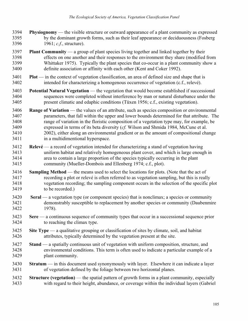
The Ecological Society of America, Vegetation Classification Panel
105
Physiognomy — the visible structure or outward appearance of a plant community as expressed 3394 by the dominant growth forms, such as their leaf appearance or deciduousness (Fosberg 3395 1961; c.f., structure). 3396
Plant Community — a group of plant species living together and linked together by their 3397 effects on one another and their responses to the environment they share (modified from 3398 Whittaker 1975). Typically the plant species that co-occur in a plant community show a 3399 definite association or affinity with each other (Kent and Coker 1992). 3400
Plot — in the context of vegetation classification, an area of defined size and shape that is 3401 intended for characterizing a homogenous occurrence of vegetation (c.f., relevé). 3402
Potential Natural Vegetation — the vegetation that would become established if successional 3403 sequences were completed without interference by man or natural disturbance under the 3404 present climatic and edaphic conditions (Tüxen 1956; c.f., existing vegetation). 3405
Range of Variation — the values of an attribute, such as species composition or environmental 3406 parameters, that fall within the upper and lower bounds determined for that attribute. The 3407 range of variation in the floristic composition of a vegetation type may, for example, be 3408 expressed in terms of its beta diversity (cf. Wilson and Shmida 1984, McCune et al. 3409 2002), either along an environmental gradient or as the amount of compositional change 3410 in a multidimentional hyperspace. 3411
Relevé — a record of vegetation intended for characterizing a stand of vegetation having 3412 uniform habitat and relatively homogeneous plant cover, and which is large enough in 3413 area to contain a large proportion of the species typically occurring in the plant 3414 community (Mueller-Dombois and Ellenberg 1974; c.f., plot). 3415
Sampling Method — the means used to select the locations for plots. (Note that the act of 3416 recording a plot or relevé is often referred to as vegetation sampling, but this is really 3417 vegetation recording; the sampling component occurs in the selection of the specific plot 3418 to be recorded.) 3419
Seral — a vegetation type (or component species) that is nonclimax; a species or community 3420 demonstrably susceptible to replacement by another species or community (Daubenmire 3421 1978). 3422
Sere — a continuous sequence of community types that occur in a successional sequence prior 3423 to reaching the climax type. 3424
Site Type — a qualitative grouping or classification of sites by climate, soil, and habitat 3425 attributes, typically determined by the vegetation present at the site. 3426
Stand — a spatially continuous unit of vegetation with uniform composition, structure, and 3427 environmental conditions. This term is often used to indicate a particular example of a 3428 plant community. 3429
Stratum — in this document used synonymously with layer. Elsewhere it can indicate a layer 3430 of vegetation defined by the foliage between two horizontal planes. 3431
Structure (vegetation) — the spatial pattern of growth forms in a plant community, especially 3432 with regard to their height, abundance, or coverage within the individual layers (Gabriel 3433

Guidelines for Describing Associations and Alliances of the U.S. NVC, Version 3.0
106
and Talbot 1984; see also, physiognomy). Elsewhere this term is used more generally to 3434 include all aspects of how communities are assembled. 3435
Subclass — the level in the NVC classification hierarchy under class (see Figure 1) based on 3436 growth form characteristics (Grossman et al. 1998). 3437
Subclimax — the stage plant succession immediately preceding the climax stage (Gabriel and 3438 Talbot 1984). 3439
Subgroup — the level in the NVC classification hierarchy below group (see Figure 1) that 3440 separates “natural or seminatural” from “cultural” vegetation (planted or cultivated; 3441 Grossman et al. 1998). 3442
Taxon-concept —When used with respect to taxonomic nomenclature, the combination of a 3443 taxon name along with a reference to a circumscribed taxonomic concept (as in “potential 3444 taxon” of Berendsohn (1995) or “assertion” of Pyle (2004)). 3445
Vegetation — the collective plant cover of an area (FGDC 1997). 3446

The Ecological Society of America, Vegetation Classification Panel
107
APPENDIX 1 3447
Required and optimal attributes for classification and occurrence plot records. Classification 3448 plots provide data needed to develop and define classified vegetation types (associations and 3449 alliances). Occurrence plots document a less formal observation of a known association or 3450 alliance at a location. Required fields are those minimally needed to serve as either classification 3451 or occurrence plots. Optimal fields are those fields that, while not required, reflect best practices 3452 when recording plots. 3453
Appendix 1 Table Index 3454
1. Information that should be included on the form used to record plot data in the field. 3455
1.1. Field form information about the plot record. 3456
1.2. Field form information about the plot vegetation. 3457
1.3. Field form information about the plot location. 3458
1.4. Field form information about the plot environment. 3459
1.5. Field form information about the plot habitat. 3460
2. Information that should be included as metadata. 3461
2.1. Metadata about the original field project for which the plot record was collected. 3462
2.2. Metadata about the plot and the plot observation. 3463
2.3. Metadata about the methods used to collect the field data. 3464
2.4. Metadata about the human sources of the field data. 3465
2.5. Metadata about references for other sources of plot data. 3466
2.6. Metadata about plot record confidentiality and links to publications and sources. 3467
3. Information that should be included about each assignment of a field plot to a vegetation type 3468 or types in the NVC. 3469
For access to an ASCII file of each table as well as more detailed information, see 3470 http://www.vegbank.org. 3471
3472
1. Information that should be included on the form used to record plot data in the field. The 3473 attribute names derive from the attribute names in the VegBank plot archive (with the exception 3474 that underscore symbols have been added to improve readability). 3475
1.1. Field form information about the plot record. 3476
Attribute Name Attribute Definition Classification Plots
Occurrence Plots
Author Plot Code Author's plot number/code, or the original plot number if taken from literature.
Required Required

Guidelines for Describing Associations and Alliances of the U.S. NVC, Version 3.0
108
Attribute Name Attribute Definition Classification Plots
Occurrence Plots
Author Observation Code
Code or name that the author uses to identify this plot observation. Where a plot has only one observation, this code may equal Author Plot Code.
Required Optimal
Placement Method Description of the method used to determine the placement of a plot. Optimal Optimal
Observation Start Date
The date of the observation, or the first day if the observation spanned more than one day.
Required Required
Observation Stop Date
The last day of the observation if the observation spanned more than one day.
Optimal Optimal
Date Accuracy
Estimated accuracy of the observation date. Accuracy is often low for legacy data. See Table 3, Appendix 2 for a constrained vocabulary.
Required Optimal
3477 3478 3479 1.2. Field form information about the plot vegetation. 3480
Attribute Name Attribute Definition Classification Plots
Occurrence Plots
Dominant Stratum Identify the dominant stratum (of the six standard strata) Optimal Optimal
Growth Form 1 The predominant growth form. Optimal Optimal
Growth Form 2 The second-most predominant growth form. Optimal Optimal
Growth Form 3 The third-most predominant growth form Optimal Optimal
Growth Form 1 Cover
Total cover of the predominant growth form. Optimal Optimal
Growth Form 2 Cover
Total cover of the second-most predominant growth form. Optimal Optimal
Growth Form 3 Cover
Total cover of the third-most predominant growth form. Optimal Optimal
Basal Area Total basal area of woody stems in m2/ha Optimal Optimal
The following stratum variables are recorded once for each stratum recognized.
While not strictly required, measurements of strata are a best practice. If strata are measured, the first three and last are required

The Ecological Society of America, Vegetation Classification Panel
109
Attribute Name Attribute Definition Classification Plots
Occurrence Plots
Stratum Index Indices used to represent stratum Required
only if strata are recorded
Optimal
Stratum Name Name of stratum Required
only if strata are recorded
Optimal
Stratum Description Description of stratum Required
only if strata are recorded
Optimal
Stratum Height Average height to the top of the stratum in meters. Optimal Optimal
Stratum Base Average height of the bottom of the stratum in meters. Optimal Optimal
Stratum Cover Total cover of vegetation within the given stratum in percent.
Required only if strata are recorded
Optimal
The following apply for recording plant taxa, with at least one record per taxon, and
multiple records when taxa are observed in multiple strata.
Plant Name
Name of the taxon. For occurrence plots, only dominant taxa are required, whereas for classification plots a comprehensive list of taxa is required.
Required Required
Plant Reference
Authority followed for taxon (could be entered by taxon, or collectively for the whole plot or as a default where not otherwise specified in the metadata).
Required Required
Taxon Stratum Cover Percent cover of taxon in stratum. Optimal Optimal
Taxon Cover
Overall cover of the taxon across all strata. For occurrence plots, only dominant taxa are required, whereas for classification plots a comprehensive list of taxa is required.
Required Required
Taxon Inference Area
This is the area in square meters used to estimate the cover of a given taxon. Generally this should be equal to Taxon Observation Area, but at times this area may be larger or smaller for a specific taxon.
Required Optimal
Taxon Basal Area Total basal area of woody stems in m2/ha for a given taxon, usually for Optimal Optimal

Guidelines for Describing Associations and Alliances of the U.S. NVC, Version 3.0
110
Attribute Name Attribute Definition Classification Plots
Occurrence Plots
those with a tree growth form.
Taxon Stem Count The number of stems of a given taxon, usually for those with a tree growth form.
Optimal Optimal
3481 3482 3483
1.3. Field form information about the plot location (some can be determined after a return to 3484 office, for example, with coordinate conversions). 3485
Attribute Name Attribute Definition Classification Plots
Occurrence Plots
Latitude & Longitude
WGS84 Latitude and Longitude of the plot origin in degrees and decimals following any adjustments, conversions and postprocessing.
Required Required
Type of Field Coordinates
Coordinates recorded in the field (latitude and longitude with datum, UTM with datum, or alternative geographic projection with units, longitude of center of projection, latitude of center of projection, False easting, False northing, X axis shift, & Y axis shift)
Required Required
Location Accuracy
Estimated accuracy of the location of the plot. Plot origin has a 95% or greater probability of being within this many meters of the reported location.
Optimal Required
Location Narrative Text description that provides information useful for plot relocation. Optimal Optimal
Area Total area of the plot in square meters. If many subplots, this area includes the subplots and the interstitial space.
Required Optimal
Stand Size Estimated size of the stand of vegetation in which the plot occurs. Optimal Optimal
USGS Quad U.S. Geological Survey 7.5 minute quadrangle name.
Optimal Optimal
Ecoregion Bailey (1995) Ecoregion Section. Optimal Optimal Place name Country Country of plot location. Optimal Optimal Place Name State/Prov.
State, province, or similar subnational jurisdiction. Optimal Optimal
Place Name Canton County, township, parish, or similar local jurisdiction. Optimal Optimal
3486

The Ecological Society of America, Vegetation Classification Panel
111
3487 1.4. Field form information about the plot environment. 3488
Attribute Name Attribute Definition Classification
Plots Occurrence
Plots
Elevation The elevation of the plot origin in meters above sea level. Optimal Optimal
Elevation Accuracy The accuracy of the elevation in percentage of the elevation reported. Optimal Optimal
Slope Aspect
Representative azimuth of slope gradient (0-360 degrees; -1 if too flat to determine; -2 if too irregular to determine).
Optimal Optimal
Slope Gradient Representative inclination of slope in degrees; if too irregular to determine, = -1.
Optimal Optimal
Topographic Position
Position of the plot on land surface (e.g., summit, shoulder, upper slope, middle slope, lower slope, toeslope, no slope, channel bed, dune swale, pond). See Table 19, Appendix 2 for a constrained vocabulary.
Optimal Optimal
Landform
Landform type. See U.S. Department of Agriculture, Natural Resources Conservation Service, 2002. National Soil Survey Handbook, Part 629 Exhibit 1, Parts I.A & I.B. (Online at http://soils.usda.gov/technical/handbook/contents/part629p2.html#ex1) for a list of landform terms.
Optimal Optimal
Geology Surface geology type. See Table 18, Appendix 2 for a constrained vocabulary.
Optimal Optimal
Hydrologic Regime
Hydrologic regime based on, frequency and duration of flooding) (Cowardin et al. 1979). See Table 8, Appendix 2 for a constrained vocabulary.
Optimal Optimal
Soil Moisture Regime
Soil moisture regime, such as xeric, mesic, hygric, hydric. See Table 11, Appendix 2 for a constrained vocabulary.
Optimal Optimal
Soil Drainage
Drainage of the site (generally consistent with USDA classes). See Table 10, Appendix 2 for a constrained vocabulary.
Optimal Optimal
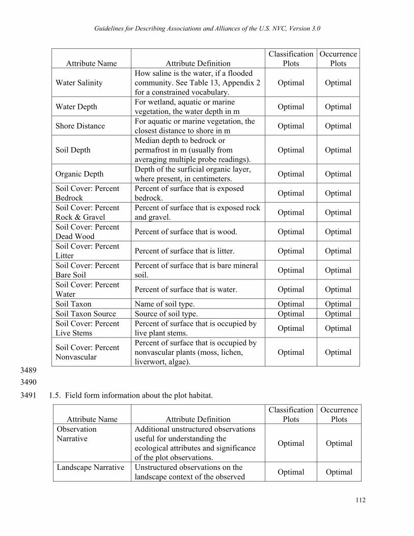
Guidelines for Describing Associations and Alliances of the U.S. NVC, Version 3.0
112
Attribute Name Attribute Definition Classification
Plots Occurrence
Plots
Water Salinity How saline is the water, if a flooded community. See Table 13, Appendix 2 for a constrained vocabulary.
Optimal Optimal
Water Depth For wetland, aquatic or marine vegetation, the water depth in m Optimal Optimal
Shore Distance For aquatic or marine vegetation, the closest distance to shore in m Optimal Optimal
Soil Depth Median depth to bedrock or permafrost in m (usually from averaging multiple probe readings).
Optimal Optimal
Organic Depth Depth of the surficial organic layer, where present, in centimeters. Optimal Optimal
Soil Cover: Percent Bedrock
Percent of surface that is exposed bedrock. Optimal Optimal
Soil Cover: Percent Rock & Gravel
Percent of surface that is exposed rock and gravel. Optimal Optimal
Soil Cover: Percent Dead Wood Percent of surface that is wood. Optimal Optimal
Soil Cover: Percent Litter Percent of surface that is litter. Optimal Optimal
Soil Cover: Percent Bare Soil
Percent of surface that is bare mineral soil. Optimal Optimal
Soil Cover: Percent Water Percent of surface that is water. Optimal Optimal
Soil Taxon Name of soil type. Optimal Optimal Soil Taxon Source Source of soil type. Optimal Optimal Soil Cover: Percent Live Stems
Percent of surface that is occupied by live plant stems. Optimal Optimal
Soil Cover: Percent Nonvascular
Percent of surface that is occupied by nonvascular plants (moss, lichen, liverwort, algae).
Optimal Optimal
3489 3490 1.5. Field form information about the plot habitat. 3491
Attribute Name Attribute Definition Classification
Plots Occurrence
Plots Observation Narrative
Additional unstructured observations useful for understanding the ecological attributes and significance of the plot observations.
Optimal Optimal
Landscape Narrative Unstructured observations on the landscape context of the observed Optimal Optimal

The Ecological Society of America, Vegetation Classification Panel
113
Attribute Name Attribute Definition Classification
Plots Occurrence
Plots plot.
Homogeneity Homogeneity of the community (e.g., homogeneous, compositional trend across plot, conspicuous inclusions, irregular mosaic or pattern)? See Table 7, Appendix 2 for a constrained vocabulary.
Optimal Optimal
Phenological Aspect Season expression of the community (e.g., typical growing season, vernal, aestival, wet, autumnal, winter, dry, irregular ephemerals present). See Table 9, Appendix 2 for a constrained vocabulary.
Optimal Optimal
Representativeness Narrative description of how representative the plot is of the stand. Optimal Optimal
Stand Maturity Assess maturity of stand (e.g., young, mature but even-aged, old-growth, etc.) See Table 12, Appendix 2 for a constrained vocabulary.
Optimal Optimal
Successional Status Description of the assumed successional status of the plot. Optimal Optimal
The following should be repeated once for each type of disturbance reported
Disturbance Type The type of disturbance being
reported. Repeat this field as many times as necessary where there is more than one type of disturbance
Optimal Optimal
Disturbance Intensity Intensity or degree of disturbance. Values are: High, Medium, Low, None.
Optimal Optimal
Disturbance Age Estimated time in years since the disturbance event Optimal Optimal
Disturbance Extent Percent of the plot that experienced the event Optimal Optimal
Disturbance Comment
Text description of details of the disturbance and its impact on the vegetation. Repeat this field as many times as necessary where there is more than one type of disturbance
Optimal Optimal
3492 3493
2. Information that should be included as metadata. 3494

Guidelines for Describing Associations and Alliances of the U.S. NVC, Version 3.0
114
2.1. Metadata about the original field project for which the plot record was collected. 3495
Attribute Name Attribute Definition Classification Plots
Occurrence Plots
Project Name Project name as defined by the principal investigator. Optimal Optimal
Project Description
Short description of the project including the original purpose for conducting the project. This can be viewed as the project abstract plus supporting metadata.
Optimal Optimal
Start Date Project start date. Optimal Optimal Stop Date Project stop date. Optimal Optimal
3496 3497
2.2. Metadata about the plot and the plot observation. 3498
Attribute Name Attribute Definition Classification Plots
Occurrence Plots
Layout Narrative Text description of and the rationale for the layout of the plot. Optimal Optimal
Method Narrative Additional metadata helpful for understanding how the data were collected during the observation event.
Optimal Optimal
Plot Type
Indicate if information is recorded from the entire plot or from subplots. If from subplots indicate how the subplots were configured: contiguous, regular, random, or haphazard (see Appendix 2, Table 2).
Required Optimal
Taxon Observation Area
The total surface area (in square meters) used for cover estimates and for which a complete species list is provided. If subplots were used, this would be the total area of the subplots without interstitial space.
Required Optimal
Cover Dispersion
Indication of how cover values for the total taxon list were collected; i.e., from one contiguous area or dispersed subplots (e.g., contiguous, dispersed-regular, dispersed-random)?
Required Optimal
Original Data Location where the hard data reside and any access instructions. Optimal Optimal
Effort Level Effort spent making the observations as estimated by the party that submitted the data. Values are: very
Optimal Optimal
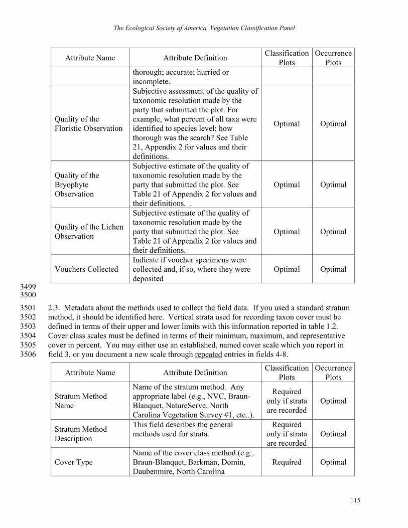
The Ecological Society of America, Vegetation Classification Panel
115
Attribute Name Attribute Definition Classification Plots
Occurrence Plots
thorough; accurate; hurried or incomplete.
Quality of the Floristic Observation
Subjective assessment of the quality of taxonomic resolution made by the party that submitted the plot. For example, what percent of all taxa were identified to species level; how thorough was the search? See Table 21, Appendix 2 for values and their definitions.
Optimal Optimal
Quality of the Bryophyte Observation
Subjective estimate of the quality of taxonomic resolution made by the party that submitted the plot. See Table 21 of Appendix 2 for values and their definitions. .
Optimal Optimal
Quality of the Lichen Observation
Subjective estimate of the quality of taxonomic resolution made by the party that submitted the plot. See Table 21 of Appendix 2 for values and their definitions.
Optimal Optimal
Vouchers Collected Indicate if voucher specimens were collected and, if so, where they were deposited
Optimal Optimal
3499 3500
2.3. Metadata about the methods used to collect the field data. If you used a standard stratum 3501 method, it should be identified here. Vertical strata used for recording taxon cover must be 3502 defined in terms of their upper and lower limits with this information reported in table 1.2. 3503 Cover class scales must be defined in terms of their minimum, maximum, and representative 3504 cover in percent. You may either use an established, named cover scale which you report in 3505 field 3, or you document a new scale through repeated entries in fields 4-8. 3506
Attribute Name Attribute Definition Classification Plots
Occurrence Plots
Stratum Method Name
Name of the stratum method. Any appropriate label (e.g., NVC, Braun-Blanquet, NatureServe, North Carolina Vegetation Survey #1, etc..).
Required only if strata are recorded
Optimal
Stratum Method Description
This field describes the general methods used for strata.
Required only if strata are recorded
Optimal
Cover Type Name of the cover class method (e.g., Braun-Blanquet, Barkman, Domin, Daubenmire, North Carolina
Required Optimal
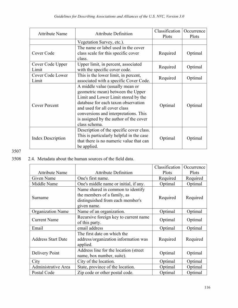
Guidelines for Describing Associations and Alliances of the U.S. NVC, Version 3.0
116
Attribute Name Attribute Definition Classification Plots
Occurrence Plots
Vegetation Survey, etc.).
Cover Code The name or label used in the cover class scale for this specific cover class.
Required Optimal
Cover Code Upper Limit
Upper limit, in percent, associated with the specific cover code. Required Optimal
Cover Code Lower Limit
This is the lower limit, in percent, associated with a specific Cover Code. Required Optimal
Cover Percent
A middle value (usually mean or geometric mean) between the Upper Limit and Lower Limit stored by the database for each taxon observation and used for all cover class conversions and interpretations. This is assigned by the author of the cover class schema.
Optimal Optimal
Index Description
Description of the specific cover class. This is particularly helpful in the case that there is no numeric value that can be applied.
Optimal Optimal
3507 2.4. Metadata about the human sources of the field data. 3508
Attribute Name Attribute Definition Classification
Plots Occurrence
Plots Given Name One's first name. Required Required Middle Name One's middle name or initial, if any. Optimal Optimal
Surname
Name shared in common to identify the members of a family, as distinguished from each member's given name.
Required Required
Organization Name Name of an organization. Optimal Optimal
Current Name Recursive foreign key to current name of this party. Optimal Optimal
Email email address Optimal Optimal
Address Start Date The first date on which the address/organization information was applied.
Required Required
Delivery Point Address line for the location (street name, box number, suite). Optimal Optimal
City City of the location. Optimal Optimal Administrative Area State, province of the location. Optimal Optimal Postal Code Zip code or other postal code. Optimal Optimal

The Ecological Society of America, Vegetation Classification Panel
117
Attribute Name Attribute Definition Classification
Plots Occurrence
Plots Country Country of the physical address. Optimal Optimal
The following can be repeated an indefinite number of times per person
Role: Plot submitter Name of the person submitting the analysis. Required Required
Role: Plot Primary Field Observer
Name of the person who made the field observation (e.g., PI, technician, volunteer, etc.).
Required Required
Role: Plot Author Name of the author of the plot record. Required Required
Role: Project PI Name of the field plot inventory project’s principal investigator. Optimal Optimal
Role: Other Report other roles as appropriate. Optimal Optimal 3509 2.5 Metadata about references for other sources of plot data. These fields are used when plot 3510 observations are taken from published literature sources. 3511
Attribute Name Attribute Definition Classification
Plots Occurrence
Plots
Authors Name of authors if plot record is taken from published work. Required Required
Title Title of publication, if plot record is taken from published work. Required Required
Publication Date Date of publication, if plot record is taken from published work. Required Required
Edition Edition of publication if applicable, and if plot record is taken from published work.
Required Required
Series Name Name of publication series, if applicable, and if plot record is taken from published work.
Required Required
Page Page number of publication, if plot record is taken from published work. Required Required
Table Cited Table number or code, if applicable and if plot record is taken from published work.
Required Required
Plot Cited Original plot name, if plot record is taken from published work. Required Required
ISBN International Standard Book Number (ISBN), if applicable, and if plot record is taken from published book.
Optimal Optimal
ISSN International Standard Serial Number, if applicable. Optimal Optimal

Guidelines for Describing Associations and Alliances of the U.S. NVC, Version 3.0
118
Attribute Name Attribute Definition Classification
Plots Occurrence
Plots
Short Name Provides a concise or abbreviated name that describes the resource that is being documented.
Optimal Optimal
Citation Type
Describes the type of reference this generic type is being used to represent. Examples: book, journal article, webpage.
Required Required
Title The formal title given to the work by its author or publisher. Required Required
Title Superior
A second, higher order title where appropriate, which in the case of a reference to a chapter is the Book title, and in the case of a Conference Presentation is the Name of the Conference.
Optimal Optimal
Pub Date Represents the date that the reference was published. Required Required
Access Date
The date the reference being referenced was accessed. This is useful if the reference is could be changed after formal publication, such as websites or databases.
Required Required
Conference Date The date the conference was held. Required Required
Volume The volume of the journal in which the article appears. Required Required
Issue The issue of the journal in which the article appears. Required Required
Page Range The beginning and ending pages of the journal article that is being documented.
Required Required
Total Pages The total number of pages in the book that is being described. Required Required
Publisher The organization that physically put together the report and publishes it. Required Required
Publication Place
The location at which the work was published. This is usually the name of the city in which the publishing house produced the work.
Required Required
ISBN The ISBN, or International Standard Book Number assigned to this literature reference.
Required Required
Edition The edition of the generic reference type that is being described. Required Required

The Ecological Society of America, Vegetation Classification Panel
119
Attribute Name Attribute Definition Classification
Plots Occurrence
Plots Number Of Volumes Number of volumes in a collection Required Required
Chapter Number The chapter number of the chapter of a book that is being described. Required Required
Report Number
The unique identification number that has been issued by the report institution for the report being described.
Required Required
Communication Type
The type of personal communication. Could be an email, letter, memo, transcript of conversation either hardcopy or online.
Optimal Optimal
Degree The name or degree level for which the thesis was completed. Optimal Optimal
URL
A URL (Uniform Resource Locator) from which this reference can be downloaded or additional information can be obtained.
Optimal Optimal
DOI
A Digital Object Identifier - a digital identifier for any object of intellectual property. A DOI provides a means of persistently identifying a piece of intellectual property on a digital network and associating it with related current data.
Optimal Optimal
Additional Info
Any information that is not characterized by the other reference metadata fields. Example: Copyright 2001, Robert Warner
Optimal Optimal
Journal
The name of the publication in which the article was published. Example(s): Ecology, New York Times, Harper's, Canadian Journal of Botany/Revue Canadienne de Botanique, The Journal of the American Medical Association
Required Required
ISSN
The ISSN, or International Standard Serial Number assigned to this literature reference. Example(s): ISSN 1234-5679
Required Required
Abbreviation Standard abbreviation or shorter name of the journal. Example(s): Can. J. Bot./Rev. Can. Bot., JAMA
Optimal Optimal
The following can be repeated an indefinite number of times for each alternate identifier

Guidelines for Describing Associations and Alliances of the U.S. NVC, Version 3.0
120
Attribute Name Attribute Definition Classification
Plots Occurrence
Plots used to describe the reference.
System
The data management system within which a plot identifier is found. This is typically a URL (Uniform Resource Locator) that indicates a data management system. All identifiers that share a system must be unique. In other words, if the same identifier is used in two locations with identical systems, then by definition the objects at which they point are in fact the same object. Example: http://metacat.somewhere.org/svc/mc/
Optimal Optimal
Identifier
An additional, secondary identifier for this reference. The primary identifier belongs in the reference table, but additional identifiers that are used to label this reference, possibly from different data management systems, can be listed here. Example: VCR3465
Optimal Optimal
The following can be repeated an indefinite number of times for each contributor to the
reference (e.g. author, editor).
Role Type
The role the party played with respect to the reference contribution. Some potential roles include technician, reviewer, principal investigator, and many others.
Required Required
Order
Numerical order in which this contributor's name should be in the order of contributors, if applicable. Examples: 1 [for the first author], 2, [for the second author], etc.
Required Required
Type The type of Party that a given record refers to, usually a person or institution.
Required Required
Position Name
This field is intended to be used to indicate the position occupied by a person within an institution. Position Name is needed for consistency in cases where the associated person that
Optimal Optimal

The Ecological Society of America, Vegetation Classification Panel
121
Attribute Name Attribute Definition Classification
Plots Occurrence
Plots holds the role changes frequently.
Salutation
The salutation field is used in addressing an individual with a particular title, such as Dr., Ms., Mrs., Mr., etc.
Optimal Optimal
Given Name
The given name field is used for all names except the surname of the individual. Examples: Jo, Jo R., Jo R.W., John Robert Peter
Required Required
Surname The surname field is used for the last name of the individual.
Required Required
Suffix A suffix or suffix abbreviation that follows a name. Examples: Jr., Senior, III, etc.
Optimal Optimal
Organization Name
The full name of the organization that is associated with the reference contribution. This field is intended to describe which institution or overall organization is associated with the resource being described.
Optimal Optimal
Current Party A link to the record of the current name of the party, if different from the name used in this record.
Optimal Optimal
3512
3513 2.6. Metadata about plot record confidentiality and links to publications and sources. 3514
Attribute Name Attribute Definition Classification Plots
Occurrence Plots
Confidentiality Status
Are the data to be considered confidential? 0=no, 1= 1km radius, 2=10km radius, 3=100km radius, 4=location embargo, 5=public embargo on all plot data, 6=full embargo on all plot data.
Optimal Optimal
Confidentiality Reason
The reason for confidentiality. This field should not be open to public view. Reasons might include specific rare species, ownership, prepublication embargo, or many other reasons.
Optimal Optimal

Guidelines for Describing Associations and Alliances of the U.S. NVC, Version 3.0
122
Attribute Name Attribute Definition Classification Plots
Occurrence Plots
Classification Publication ID
Link to a publication wherein the observation was classified. Optimal Optimal
Community Authority ID
Link to the reference from which information on the community concept was obtained during the classification event.
Optimal Optimal
3515 3516
3. Information that should be included about each assignment of a field plot to a vegetation type 3517 in the NVC, or other party-specific classification. Assignment, per se, of a plot to a 3518 classification type is not required. 3519
Attribute Name Attribute Definition Classification Plots
Occurrence Plots
Classification Start Date
Start date for the application of a vegetation class to a plot observation by one or more parties.
Required Required
Inspection Was the classification informed by simple inspection of data (Yes/No)? Optimal Optimal
Table Analysis Was the classification informed by inspection of floristic composition tables (Yes/No)?
Optimal Optimal
Multivariate Analysis Was the classification informed by use of multivariate numerical tools (Yes/No)?
Optimal Optimal
Expert System Was the classification informed by use of automated expert system (Yes/No)? Optimal Optimal
Classifier
Name of person who classified the plot – this should link to a person included in the human resources metadata table.
Required Required
Interpretation Date The date that the interpretation was made.
Required if known Required
Interpretation Type
Categories for the interpretation (e.g., author, computer-generated, simplified for comparative analysis, correction, finer resolution).
Required if known Required
Original Interpretation
Does this interpretation correspond to the original interpretation of the plot author, as best as can be determined. There is no requirement that the authority match the authority of the author; only that the concepts are
Required if known Required

The Ecological Society of America, Vegetation Classification Panel
123
Attribute Name Attribute Definition Classification Plots
Occurrence Plots
synonymous.
Current Interpretation This interpretation is the most accurate and precise interpretation currently available.
Required if known Required
The following may be repeated for each community type associated with a plot during a classification event
Community Name Name of the community Required if known Required
Community Reference
Reference wherein the above name is defined
Required if known Required
Classification Fit
Indicates the degree of fit with the community concept being assigned (e.g., fits concept well, fits but not typal, possible fit, just outside concept). See Table 23 of Appendix 2 for standard classification fit categories and codes.
Optimal Optimal
Classification Confidence
Indicates the degree of confidence of the interpreter (s) in the interpretation made. This can reflect the level of familiarity with the classification or the sufficiency of information about the plot (e.g., high, moderate, low).
Optimal Optimal
3520

Guidelines for Describing Associations and Alliances of the U.S. NVC, Version 3.0
124
APPENDIX 2 3521
Recommended Constrained Vocabularies. The following lists are vocabularies that should be 3522 used when recording plot information that describes a condition of the following subjects. These 3523 standardized vocabularies are used in database “picklists” and greatly facilitate standardized data 3524 types and information exchange. 3525 Table Index 3526
1. Disturbance Types 3527 2. Plot Observation Types 3528 3. Accuracy of Time of Day 3529 4. Accuracy of Date 3530 5. Vegetation Stratum Types 3531 6. Growth Form Types 3532 7. Homogeneity of Plot 3533 8. Hydrologic Regime of Plot 3534 9. Phenologic Aspect of Plot 3535 10. Soil Drainage of Plot 3536 11. Soil Moisture Regime of Plot 3537 12. Stand Maturity 3538 13. Water Salinity 3539 14. Rock Types 3540 15. Placement Method of Plot 3541 16. Plot Shape 3542 17. Stand Size 3543 18. Surficial Geologic Material 3544 19. Topographic Position 3545 20. Soil Texture 3546 21. Quality of the Floristic Observation 3547 22. Plot Confidentiality Codes 3548 23. Classification Fit3549

The Ecological Society of America, Vegetation Classification Panel
125
3550 Appendix 2, Table 1.
Disturbance Types Avalanche and snow Cryoturbation Cultivation Erosion Fire suppression Fire, canopy Fire, ground Fire, general Flood Grazing, domestic stock Grazing, native ungulates Herbicide or chemical Herbivory, vertebrates Hydrologic alteration Ice Invertebrate caused Mass land movement (landslides) Mowing Other disturbance Plant disease Roads and vehicular traffic Salt spray Tidal Timber harvest, general Timber harvest, clearcut Timber harvest, selective Trampling and trails Wind, chronic Wind event
3551

Guidelines for Describing Associations and Alliances of the U.S. NVC, Version 3.0
126
3552 Appendix 2, Table 2
Plot Observation Types Descriptions of Plot Observation Types
Entire Cover based on observation of an entire plot consisting of a single contiguous area of land.
Subplot-contiguous Cover based on observation of a single contiguous area of land of less spatial extent than the entire plot.
Subplot-regular Cover based on observation of multiple subplots arranged in a regular pattern within the overall plot.
Subplot-random Cover based on observation of multiple randomly dispersed within the overall plot.
Subplot-haphazard Cover based on observation of multiple subplots haphazardly arranged within the overall plot.
3553 Appendix 2, Table 3
Accuracy of Time of Day
Descriptions of Time of Day Accuracy Categories
One minute Time of day is accurate to within one minute
One hour Time of day is accurate to within one hour Quarter-day Time of day is accurate to within one
quarter-day (e.g., during morning, during afternoon)
Half day Time of day is accurate to within one half-day (e.g., between 00:00 and 11:59, or between 12:00 and 23:59)
3554 Appendix 2, Table 4
Accuracy of Date Descriptions of Date Accuracy Categories One day Date accurate to within one day One week Date accurate to within one week One month Date accurate to within one month Three months Date accurate to within three months One year Date accurate to within one year Three years Date accurate to within three years Ten years Date accurate to within then years Greater than ten years Date accurate to within more than ten
years 3555

The Ecological Society of America, Vegetation Classification Panel
127
3556 Appendix 2, Table 5 NOTE: Vegetation strata are not to be confused with life forms.
Vegetation Stratum Types Descriptions of Vegetation Stratum Types
Tree Includes tall trees (single-stemmed woody plants, generally more than 5 m in height or greater at maturity under optimal growing conditions). Very tall shrubs with tree-like form may also be included here, as may other life forms, such as lianas and epiphytes, and their contribution to the stratum can be further specified using the “life form” field.
Shrub Includes shrubs (multiple-stemmed woody plants, generally less than 5 m in height at maturity under optimal growing conditions) and by shorter trees (saplings). As with the tree stratum, other life forms present in this stratum may also be included (however, herbaceous life forms should be excluded, as their stems often die back annually and do not have as consistent a height as woody life forms). Where dwarf-shrubs (i.e. shrubs < 0.5 m) form a distinct stratum (either as part of a series of strata, as in a forest, or as the top stratum of more open vegetation, such as tundra or xeric shrublands), they should be treated as a low version of the shrub stratum (or short shrub substratum). In many vegetation types, dwarf-shrubs may simply occur as one life form component of the herb stratum (see below).
Herb Also referred to as field stratum. Includes herbs (plants without woody stems and often dying back annually), often in association with low creeping semi-shrubs, dwarf-shrubs, vines, and non-woody brambles (such as raspberries), as well as tree or shrub seedlings.
Moss Also referred to as nonvascular, bryoid, or ground stratum. Defined entirely by mosses, lichens, liverworts, and alga. Ground-creeping vines, prostrate shrubs and herbs should be treated in the herb stratum. Where herbs are entirely absent, it is still possible to recognize this stratum if other very low woody or semi-woody life forms are present.
Floating Includes rooted or drifting plants that float on the water surface (e.g., duckweed, water-lily).
Submerged Includes rooted or drifting plants that by-and-large remain submerged in the water column or on the aquatic bottom (e.g., pondweed). The focus is on the overall strata arrangement of these aquatic plants. Note that emergent plants life forms in a wetland should be placed in the strata listed above (e.g., cattail or sedges would be placed in the herb stratum, whereas the duckweed would be in the floating aquatic stratum).
3557

Guidelines for Describing Associations and Alliances of the U.S. NVC, Version 3.0
128
3558 Appendix 2, Table 6
Growth Form Types Alga Aquatic herb Bamboo Broad-leaved deciduous shrub Broad-leaved deciduous tree Broad-leaved evergreen shrub Broad-leaved evergreen tree Bryophyte Dwarf-shrub Epiphyte Evergreen sclerophyllous shrub Evergreen sclerophyllous tree Fern or fern allie Forb Graminoid Lichen Needle-leaved shrub Needle-leaved tree Palm shrub Palm tree Semi-shrub Succulent forb Succulent shrub Succulent tree Thorn shrub Thorn tree Tree fern Vine/Liana (woody climbers or vines) 3559 3560 3561 Appendix 2, Table 7
Homogeneity of Plot Homogeneous Compositional trend across plot Conspicuous inclusions Irregular or pattern mosaic 3562

The Ecological Society of America, Vegetation Classification Panel
129
3563 Appendix 2, Table 8
Hydrologic Regime of Plot Semipermanently flooded Seasonally flooded Saturated Seasonally saturated Temporarily flooded Intermittently flooded Permanently flooded Permanently flooded - tidal Tidally flooded Wind-tidally flooded Irregularly flooded Irregularly exposed Upland Unknown 3564 Appendix 2, Table 9
Phenologic Aspect of Plot Typical growing season Vernal Early wet season Aestival Wet season Autumnal Late wet season Winter Dry season Irregular ephemeral phase 3565 Appendix 2, Table 10
Soil Drainage of Plot Excessively drained Somewhat excessively drained Well drained Moderately well drained Somewhat poorly drained Poorly drained Very poorly drained 3566

Guidelines for Describing Associations and Alliances of the U.S. NVC, Version 3.0
130
3567 Appendix 2, Table 11
Soil Moisture Regime of Plot Very xeric Xeric Subxeric Submesic Mesic Subhygric Hygric Subhydric Hydric 3568 Appendix 2, Table 12
Stand Maturity Young, regenerative Even-age, aggrading Mature, even-age Transition, breakup Old growth or senescent, all-age Uneven-age 3569 Appendix 2, Table 13
Water Salinity
Description of Water Salinity
Saltwater greater than 30 ppt Brackish 0.5 to 30 ppt Freshwater less than 0.5 ppt 3570

The Ecological Society of America, Vegetation Classification Panel
131
3571 Appendix 2, Table 14 Rock Types. For definitions of these terms see Jackson 1997, or USDA, NRCS 2002. `a`a lava hornfels quartz-diorite amphibolite igneous, unspecified quartz-monzonite andesite ignimbrite quartzite anorthosite iron-manganese concretions rhyolite arenite iron-manganese nodules sandstone, calcareous argillite ironstone nodules sandstone, glauconitic arkose lapilli sandstone, unspecified basalt latite schist, mica block lava limestone, arenaceous schist, unspecified breccia, non-volcanic limestone, argillaceous scoria breccia, non-volcanic, acidic limestone, cherty sedimentary, unspecified breccia, non-volcanic, basic limestone, phosphatic serpentinite calcrete (caliche) limestone, unspecified shale, acid carbonate concretions marble shale, calcareous carbonate nodules metaconglomerate shale, clayey carbonate rock, unspecified metamorphic, foliated shale, unspecified chalk metamorphic, unspecified shell fragments charcoal metaquartzite silica concretions chert metasedimentary, unspecified siltstone, calcareous cinders metavolcanics siltstone, unspecified claystone migmatite slate coal mixed soapstone conglomerate, calcareous monzonite syenite conglomerate, unspecified mudstone syenodiorite dacite mylonite tachylite diabase obsidian tonalite diorite orthoquartzite trachyte dolomite (dolostone) ortstein fragments travertine durinodes pahoehoe lava tufa duripan fragments peridotite tuff breccia gabbro petrocalcic fragments tuff, acidic gibbsite concretions petroferric fragments tuff, basic gibbsite nodules petrogypsic fragments tuff, unspecified gneiss phyllite tuff, welded granite pillow lava ultramafic, unspecified granodiorite plinthite nodules volcanic bombs granofels porcellanite volcanic breccia, acidic granulite pumice volcanic breccia, basic graywacke pyroclastic (consolidated) volcanic breccia, unspecified greenstone pyroxenite volcanic, unspecified gypsum quartz wood

Guidelines for Describing Associations and Alliances of the U.S. NVC, Version 3.0
132
3572 Appendix 2, Table 15
Placement Method of Plot Regular Random Stratified random Transect component Representative Capture specific feature 3573 Appendix 2, Table 16
Plot Shape Rectangular Square Circle Transect/Strip Plotless Diffuse Other 3574 Appendix 2, Table 17
Stand Size Descriptions of Stand Sizes Very Extensive greater than 1000x plot size Extensive greater than 100x plot size Large 10-100x plot size Small 3-10x plot size Very small 1-3x plot size Inclusion less than 1x plot size 3575

The Ecological Society of America, Vegetation Classification Panel
133
3576 Appendix 2, Table 18
Surficial Geologic Material Residual Material: Bedrock Residual Material: Disintegrated Rock Residual Material: Deeply Weathered Rock Glacial Deposits: Undifferentiated glacial deposit Glacial Deposits: Till Glacial Deposits: Moraine Glacial Deposits: Bedrock and till Glacial Deposits: Glacial-fluvial deposits (outwash) Glacial Deposits: Deltaic deposits Alluvial Deposits: Floodplain Alluvial Deposits: Alluvial Fan Alluvial Deposits: Deltas Marine and Lacustrine Deposits: Unconsolidated Sediments Marine and Lacustrine Deposits: Coarse sediments Marine and Lacustrine Deposits: Fine-grained sediments Organic Deposits: Peat Organic Deposits: Muck Slope and Modified Deposits: Talus and scree slopes Slope and Modified Deposits: Colluvial Slope and Modified Deposits: Solifluction, landslide Aeolian Deposits: Dunes Aeolian Deposits: Aeolian sand flats and cover sands Aeolian Deposits: Loess deposits Aeolian Deposits: Volcanic Ash Chemical Deposits: Evaporites and Precipitates Other Variable 3577

Guidelines for Describing Associations and Alliances of the U.S. NVC, Version 3.0
134
3578 Appendix 2, Table 19
Topographic Position Descriptions of Topographic Positions
Interfluve crest, summit, ridge High slope shoulder slope, upper slope, convex creep slope High level mesa, high flat Midslope transportational midslope, middle slope Backslope dipslope Step in slope ledge, terracette Lowslope lower slope, foot slope, colluvial footslope Toeslope alluvial toeslope Low level terrace, low flat Channel wall bank Channel bed narrow valley bottom, gully arroyo Basin floor depression 3579
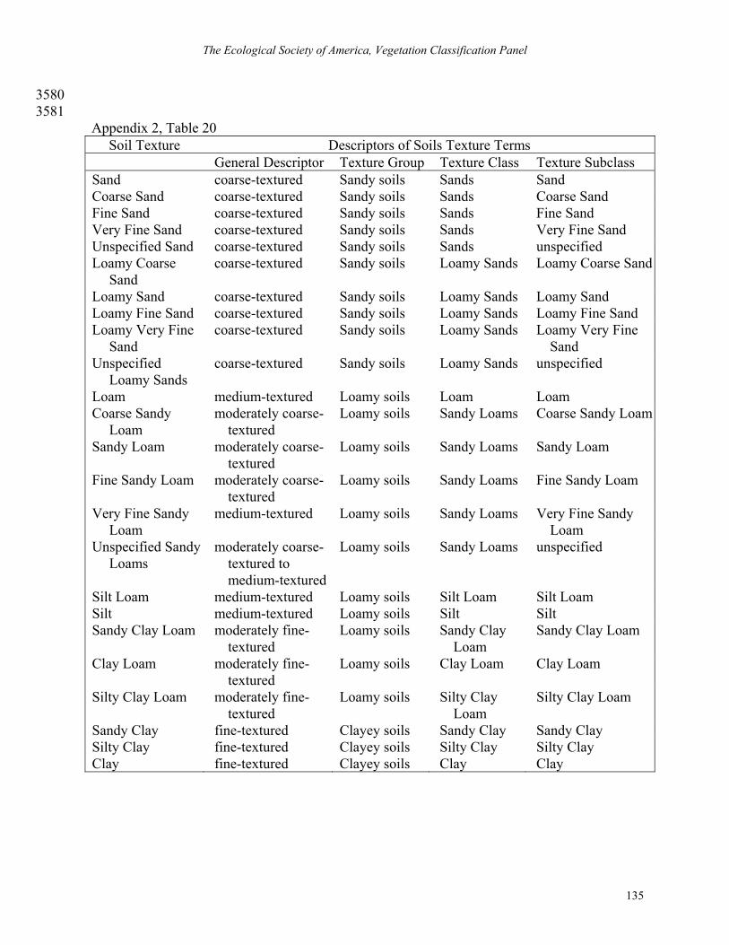
The Ecological Society of America, Vegetation Classification Panel
135
3580 3581 Appendix 2, Table 20
Soil Texture Descriptors of Soils Texture Terms General Descriptor Texture Group Texture Class Texture Subclass Sand coarse-textured Sandy soils Sands Sand Coarse Sand coarse-textured Sandy soils Sands Coarse Sand Fine Sand coarse-textured Sandy soils Sands Fine Sand Very Fine Sand coarse-textured Sandy soils Sands Very Fine Sand Unspecified Sand coarse-textured Sandy soils Sands unspecified Loamy Coarse
Sand coarse-textured Sandy soils Loamy Sands Loamy Coarse Sand
Loamy Sand coarse-textured Sandy soils Loamy Sands Loamy Sand Loamy Fine Sand coarse-textured Sandy soils Loamy Sands Loamy Fine Sand Loamy Very Fine
Sand coarse-textured Sandy soils Loamy Sands Loamy Very Fine
Sand Unspecified
Loamy Sands coarse-textured Sandy soils Loamy Sands unspecified
Loam medium-textured Loamy soils Loam Loam Coarse Sandy
Loam moderately coarse-
textured Loamy soils Sandy Loams Coarse Sandy Loam
Sandy Loam moderately coarse-textured
Loamy soils Sandy Loams Sandy Loam
Fine Sandy Loam moderately coarse-textured
Loamy soils Sandy Loams Fine Sandy Loam
Very Fine Sandy Loam
medium-textured Loamy soils Sandy Loams Very Fine Sandy Loam
Unspecified Sandy Loams
moderately coarse-textured to medium-textured
Loamy soils Sandy Loams unspecified
Silt Loam medium-textured Loamy soils Silt Loam Silt Loam Silt medium-textured Loamy soils Silt Silt Sandy Clay Loam moderately fine-
textured Loamy soils Sandy Clay
Loam Sandy Clay Loam
Clay Loam moderately fine-textured
Loamy soils Clay Loam Clay Loam
Silty Clay Loam moderately fine-textured
Loamy soils Silty Clay Loam
Silty Clay Loam
Sandy Clay fine-textured Clayey soils Sandy Clay Sandy Clay Silty Clay fine-textured Clayey soils Silty Clay Silty Clay Clay fine-textured Clayey soils Clay Clay

Guidelines for Describing Associations and Alliances of the U.S. NVC, Version 3.0
136
3582
Appendix 2, Table 21 Quality of the
Floristic Observation Descriptions of Quality of Floristic Observation Values
Highest At least 95% of all taxa were identified to species level; search was thorough.
High Between 85% and 95% of all taxa were identified to species level; search was thorough.
High but Incomplete
At least 85% of all taxa were identified to species level; search was not so thorough.
Moderate Between 70% and 85% of all taxa were identified to species level; search was thorough.
Moderate but Incomplete
Between 70% and 85% of all taxa were identified to species level; search was not so thorough.
Low Less than 70% of all taxa were identified to species level. 3583 Appendix 2, Table 22. Confidentiality
Codes Descriptions of Confidentiality Codes
1 Not confidential 2 Confidential, locality generalized to 1 km radius 3 Confidential, locality generalized to 10 km radius 4 Confidential, locality generalized to 100 km radius 5 Confidential, locality embargoed entirely 6 Confidential, all plot data embargoed
3584
Appendix 2, Table 23. Classification
Fit Codes Descriptions of Classification Fit Codes
1 Plot fits concept well 2 Plot fits, but is not typal. 3 Plot possibly fits the type. 4 Plot is just outside the concept of the type.

The Ecological Society of America, Vegetation Classification Panel
137
APPENDIX 3 3585
An example of the description of a floristic association. 3586
OVERVIEW: 3587
Names: 3588
Name: Sporobolus heterolepis - Schizachyrium scoparium - (Carex scirpoidea) / 3589
(Juniperus horizontalis) Herbaceous Association. 3590
Name, translated: Prairie Dropseed - Little Bluestem - (Scirpus-like Sedge) / (Creeping 3591
Juniper) Herbaceous Vegetation 3592
Common Name: Little Bluestem Alvar Grassland 3593
Identifier: CEGL005234 3594
Unit: ASSOCIATION 3595
Placement in Hierarchy: 3596
CLASS: V. Herbaceous 3597
FORMATION: V.A.5.N.c. Medium-tall sod temperate or subpolar grassland 3598
ALLIANCE: V.A.5.N.c.41 SPOROBOLUS HETEROLEPIS - (DESCHAMPSIA 3599
CAESPITOSA, SCHIZACHYRIUM SCOPARIUM) HERBACEOUS ALLIANCE 3600
Summary: The little bluestem alvar grassland type is found primarily in the upper Great 3601
Lakes region of the United States and Canada, in northern Michigan and southern Ontario. These 3602
grasslands occur on very shallow, patchy soils (usually less than 20 cm deep, averaging about 6 3603
cm deep) on flat alkaline limestone and dolostone outcrops (pavements). This community often 3604
has a characteristic soil moisture regime of alternating wet and dry periods. The vegetation is 3605
dominated by grasses and sedges, which tyically have at least 45% cover. Characteristic species 3606
of the grassland are Sporobolus heterolepis, Schizachyrium scoparium, Juniperus horizontalis, 3607
Carex scirpoidea, Deschampsia caespitosa, Packera paupercula (= Senecio pauperculus), and 3608
Carex crawei. There is usually less than 10% cover of shrubs over 0.5 m tall; however there may 3609
be as much as 50% cover of dwarf-shrubs (under 0.5 m tall) especially Juniperus horizontalis. 3610
Less than 50% of the ground surface is exposed bedrock (including bedrock covered with 3611
nonvascular plants: lichens, mosses, algae). 3612

Guidelines for Describing Associations and Alliances of the U.S. NVC, Version 3.0
138
Classification Comments: The most commonly associated alvar communities that 3613
occur with this community in a landscape mosaic are Juniperus horizontalis - Dasiphora 3614
fruticosa ssp. floribunda / Schizachyrium scoparium - Carex richardsonii Dwarf-shrubland 3615
(Creeping Juniper - Shrubby-cinquefoil Alvar Pavement Shrubland; CEGL005236), 3616
Deschampsia caespitosa - (Sporobolus heterolepis, Schizachyrium scoparium) - Carex crawei - 3617
Packera paupercula Herbaceous Vegetation (Tufted Hairgrass Wet Alvar 3618
Grassland;CEGL005110), Tortella tortuosa - Cladonia pocillum - Placynthium spp. Sparse 3619
Vegetation (Alvar Nonvascular Pavement;CEGL005192) and, Thuja occidentalis - Pinus 3620
banksiana / Dasiphora fruticosa ssp. floribunda / Clinopodium arkansanum Wooded 3621
Herbaceous Vegetation (White-cedar - Jack Pine / Shrubby-cinquefoil Alvar Savanna; 3622
CEGL005132) (Reschke et al. 1998). 3623
Rational for nominal species: Sporobolus heterolepis and Schizachyrium scoparium are 3624
dominants. Carex scirpoidea and Juniperus horizontalis are constants (>60% constancy) in the 3625
type. Sporobolus heterolepis, Carex scirpoidea and Deschampsia cespitosa are differential 3626
species. 3627
VEGETATION: 3628
Physiognomy and structure: The vegetation is dominated by grasses and sedges, which 3629
usually have at least 45% cover. There is usually less than 10% cover of shrubs over 0.5 m tall; 3630
however there may be as much as 50% cover of dwarf-shrubs (under 0.5 m tall) especially 3631
Juniperus horizontalis. This dwarf-shrub is shorter than the dominant grasses, and usually is 3632
found under the canopy of grasses, so the physiognomic type here is considered a grassland (in 3633
spite of relatively high cover of dwarf-shrubs). Less than 50% of the ground surface is exposed 3634
bedrock (including bedrock covered with nonvascular plants: lichens, mosses, algae). 3635
3636
Table 1. Physiognomy of the Sporobolus heterolepis - Schizachyrium scoparium - (Carex scirpoidea) / (Juniperus horizontalis) Herbaceous Association; Little Bluestem Alvar Grassland, NVC identifier code CEGL005234.
Physiognomy Average Cover Range of Cover
Tree Cover (> 5m) 1.0 0 - 15 Tree Height (m) 0.5 0 - 9 Tall Shrub Cover (2-5 m) 0.5 0 - 3

The Ecological Society of America, Vegetation Classification Panel
139
Table 1. Physiognomy of the Sporobolus heterolepis - Schizachyrium scoparium - (Carex scirpoidea) / (Juniperus horizontalis) Herbaceous Association; Little Bluestem Alvar Grassland, NVC identifier code CEGL005234.
Physiognomy Average Cover Range of Cover
Tall Shrub Height (m) 0.5 0 - 3 Short Shrub Cover (0.5-2 m) 11.0 0 - 33 Short Shrub Height (m) 1.0 0 - 1.8 Vine Cover 0.0 0 - 0 Vine Height 0.0 0 - 0 Herb Cover 46.0 4 - 99 Herb Height 0.3 0-1 Nonvascular Cover 34.0 0 - 90
3637
Floristics: Characteristic species of the grassland are Sporobolus heterolepis, 3638
Schizachyrium scoparium, Juniperus horizontalis, Carex scirpoidea, Deschampsia caespitosa, 3639
Packera paupercula (= Senecio pauperculus), and Carex crawei. Juniperus horizontalis may co-3640
dominate in some stands. 3641
Table 2: Floristic table of the Sporobolus heterolepis - Schizachyrium scoparium - (Carex scirpoidea) / (Juniperus horizontalis) Herbaceous Association; Little Bluestem Alvar Grassland, NVC identifier code CEGL005234. For species in > 10% of stands for a total of 17 field plots. Species nomenclature is according to Gleason and Cronquist (1991).
Species by Layer Constancy Avg. Cover Range of Cover, Where Present *
SHORT SHRUB LAYER (0.5-2 m) Juniperus communis 24 0.1 0.3 - 2 Juniperus horizontalis 71 8.0 1 - 33 Prunus pumila 29 0.5 0.3 - 4 Thuja occidentalis 12 0.1 0.3 - 0.3
HERB LAYER Achillea millefolium 12 0.1 0.3 - 0.3 Agropyron trachycaulum 24 0.1 0.3 - 0.3 Ambrosia artemisiifolia 18 0.1 0.3 - 0.3 Antennaria spp. 24 0.1 0.3 - 0.3 Aquilegia canadensis 18 0.1 0.3 - 0.3 Arenaria stricta 29 0.1 0.3 - 1 Aster ciliolatus 12 0.1 0.3 - 0.3 Aster laevis 47 0.5 0.3 - 2 Bromus kalmii 18 0.1 0.3 - 2 Calamagrostis canadensis 12 0.1 1 - 2 Calamintha arkansana 59 1.0 0.3 - 5

Guidelines for Describing Associations and Alliances of the U.S. NVC, Version 3.0
140
Table 2: Floristic table of the Sporobolus heterolepis - Schizachyrium scoparium - (Carex scirpoidea) / (Juniperus horizontalis) Herbaceous Association; Little Bluestem Alvar Grassland, NVC identifier code CEGL005234. For species in > 10% of stands for a total of 17 field plots. Species nomenclature is according to Gleason and Cronquist (1991).
Species by Layer Constancy Avg. Cover Range of Cover, Where Present *
Campanula rotundifolia 65 0.5 0.3 - 1 Carex aurea 12 0.1 0.3 - 0.3 Carex crawei 24 2.0 0.3 - 18 Carex eburnea 24 0.5 0.3 - 4 Carex granularis 12 0.1 0.3 - 1 Carex richardsonii 12 0.1 1 - 3 Carex scirpoidea 71 4.0 0.3 - 23 Carex viridula 41 0.5 0.3 - 2 Castilleja coccinea 29 0.1 0.3 - 1 Cladium mariscoides 12 0.5 1 - 5 Comandra umbellata 53 0.1 0.3 - 1 Danthonia spicata 53 1.0 0.3 - 5 Deschampsia cespitosa 47 1.0 0.3 - 5 Eleocharis compressa 29 0.5 0.3 - 3 Eleocharis elliptica 12 0.5 0.3 - 5 Fragaria virginiana 29 0.1 0.3 - 1 Geum triflorum 18 0.1 0.3 - 0.3 Hedyotis longifolia 18 0.5 0.3 - 5 Hypericum kalmianum 41 0.1 0.3 - 0.3 Hypericum perforatum 29 0.1 0.3 - 0.3 Muhlenbergia glomerata 12 0.1 1 - 2 Panicum spp. 35 1.0 0.3 - 5 Poa compressa 47 5.0 0.3 - 55 Polygala senega 12 0.1 0.3 - 1 Potentilla fruticosa 71 2.0 0.3 - 8 Prunella vulgaris 24 0.1 0.3 - 0.3 Rhamnus alnifolia 12 0.1 0.3 - 2 Rhus aromatica 18 0.2 0.3 - 3 Saxifraga virginiensis 12 0.1 0.3 - 0.3 Schizachyrium scoparium 71 8.0 0.3 - 38 Scirpus cespitosus 12 2.0 1 - 25 Senecio pauperculus 88 2.0 0.3 - 23 Sisyrinchium mucronatum 18 0.1 0.3 - 1 Solidago juncea 12 0.1 0.3 - 0.3 Solidago ohioensis 12 1.0 0.3 - 16 Solidago ptarmicoides 76 0.5 0.3 - 3 Solidago spp. 18 0.1 0.3 - 0.3 Sporobolus heterolepis 53 12.0 0.3 - 76 Sporobolus neglectus/vaginiflorus 24 2.0 0.3 - 25

The Ecological Society of America, Vegetation Classification Panel
141
Table 2: Floristic table of the Sporobolus heterolepis - Schizachyrium scoparium - (Carex scirpoidea) / (Juniperus horizontalis) Herbaceous Association; Little Bluestem Alvar Grassland, NVC identifier code CEGL005234. For species in > 10% of stands for a total of 17 field plots. Species nomenclature is according to Gleason and Cronquist (1991).
Species by Layer Constancy Avg. Cover Range of Cover, Where Present *
Zigadenus elegans var. glaucus 29 0.1 0.3 - 2 MOSS LAYER
Gloeocapsa /rock surface algae 47 12.0 5 - 60 Nostoc commune 41 2.0 0.3 - 18 Trentepohlia spp 29 0.1 0.3 - 0.3 Ditrichum flexicaule 24 0.1 0.3 - 3 Pseudocalliergon turgescens 18 1.0 0.3 - 15 Schistidium rivulare 24 0.5 0.3 - 10 Tortella spp. 41 3.0 0.3 - 29 Tortella tortuosa 12 0.5 0.3 - 10 Cladina rangiferina 18 0.1 0.3 - 0.3 Cladina spp. 12 0.1 0.3 - 0.3 Cladonia pyxidata 29 0.1 0.3 - 1 Cladonia spp. 18 0.1 0.3 - 2 Peltigera spp. (P. rufescens?) 12 0.1 0.3 - 0.3 Placynthium nigrum 24 0.2 0.3 - 2 Xanthoparmelia spp. 12 0.1 0.3 - 0.3
* Each species may not be present in every plot; the range of values is derived only from plots where the species has been found.
3642 Dynamics: Not documented. 3643
Environment: These grasslands occur on very shallow, patchy soils (usually less than 3644
20 cm deep, averaging about 6 cm deep) on flat limestone and dolostone outcrops (pavements). 3645
Soils are loams high in organic matter. This community often has a characteristic soil moisture 3646
regime of alternating wet and dry periods; they can have wet, saturated soils in spring and fall, 3647
combined with summer drought in most years. In large patches over 20 ha (50 acres) this 3648
grassland often occurs as a small-scale matrix, with smaller patches of other alvar communities 3649
occurring within the larger patch of little bluestem alvar grassland, forming a landscape mosaic 3650
(Reschke et al. 1998). 3651
3652
3653

Guidelines for Describing Associations and Alliances of the U.S. NVC, Version 3.0
142
Table 3. Physical environment of the Sporobolus heterolepis - Schizachyrium scoparium - (Carex scirpoidea) / (Juniperus horizontalis) Herbaceous Association; Little Bluestem Alvar Grassland, NVC identifier code CEGL005234. Continuous Variables Average Range Elevation (m) 186.0 178-209 Slope Gradient (degrees) 0.5 0 - 3 Organic Horizon Depth (cm) 1.0 0 - 8 Average Field pH 7.8 7.3 - 9 Soil Depth (cm) 4.0 1 - 9 Exposed Bedrock (%) 18.0 0 - 75 Large Rock, Surficial (% > 10 cm) 7.0 0 - 35 Small Rock, Surficial (% 0.2 - 2 cm) 10.0 0 - 72 Sand, Surficial (%) 0.0 0 - 0 Bare Soil, Surficial (%) 0.5 0 - 5 Litter (%) 2.0 0 - 12 Down Wood (% > 1 cm dbh) 0.1 0 - 1 Water (%) 0.1 0 - 1
Categorical Variables Category Number of Plots (%)
Slope Aspect Flat 7 (41) Slope Aspect South 6 (35) Slope Aspect Northeast 2 (12) Slope Aspect West 1 (6) Slope Aspect North 1 (6) Topographic Position High, level 5 (28) Topographic Position Low, level 4 (24) Topographic Position Midslope 2(12) Topographic Position Other 4 (24) Topographic Position No Value 2 (12) Soil Moisture Periodically Inundated 7 (41) Soil Moisture Moist 4 (24) Soil Moisture Somewhat Moist 3 (17) Soil Moisture Dry 1 (6) Soil Moisture Extremely Dry 1 (6) Soil Moisture No Value 1 (6)
DISTRIBUTION: 3654
Range: The little bluestem alvar grassland type is found primarily in the upper Great 3655
Lakes region of the United States and Canada, in northern Michigan, and in Ontario on 3656
The Ecological Society of America, Vegetation Classification Panel
143
Manitoulin Island and vicinity, on the Bruce Peninsula, and at a few sites further east in the 3657
Carden Plain and Burnt Lands. 3658
Nations: CA US 3659
States/Provinces: Michigan, Ontario 3660
USFS Ecoregions: 212H:CC, 212Pc:CCC 3661
PLOT SAMPLING AND ANALYSIS: 3662
Location of archived plot data: Spreadsheet files with compiled vegetation data from 3663
plots and structural types are available from The Nature Conservancy's Great Lakes Program 3664
Office or from the state or provincial Heritage Programs. Original field forms are filed at 3665
state/provincial Heritage Programs. Plot data access forthcoming (2004) at www.vegbank.org. 3666
Factors affecting data consistency: See “Methods,” below. 3667
The number and size of plots: Vegetation data were collected using 10 x 10 m relevé 3668
plots placed haphazardly within subjectively defined stands. 3669
Methods used to analyze field data and identify type: 3670
From Reschke et al. (1998): Field data collected by collaborators in Michigan, Ontario, 3671
and New York were compiled by the Heritage program staff in each jurisdiction, and provided to 3672
Carol Reschke (inventory and research coordinator for the Alvar Initiative). With assistance 3673
from a contractor (Karen Dietz), field data on vegetation, environment, and evidence of 3674
ecological processes from alvar sites were entered into spreadsheets. Spreadsheets were edited 3675
to combine a few ambiguous taxa (e.g. Sporobolus neglectus and S. vaginiflorus look similar and 3676
can only be positively distinguished when they are flowering in early fall), incorporate consistent 3677
nomenclature (Kartesz 1994), delete duplicates, and delete species that occurred in only one or a 3678
few samples. Corresponding data on the environment and evidence of ecological processes were 3679
compiled in two additional spreadsheets. The plot data set consisted of data from 85 sample 3680
plots; there were 240 taxa of vascular and nonvascular taxa included in the initial data set. 3681
The plot data set included a great deal of structural detail. If a tree species was present in 3682
different vegetation strata, then it was recorded as a separate taxon for each layer in which it 3683
occurred; for example, Thuja occidentalis might be recorded as a tree (over 5 m tall), a tall shrub 3684
(2 to 5 m tall), and a short shrub (05 to 2 m tall). The full data set of 85 samples by 240 taxa was 3685
analyzed using PC-ORD v 3.0 (McCune and Mefford 1995). Vegetation data on percent cover 3686
Guidelines for Describing Associations and Alliances of the U.S. NVC, Version 3.0
144
were relativized for each sample and then transformed with an arcsine - square root 3687
transformation. This standardization is recommended for percentage data (McCune and Mefford 3688
1995). 3689
Two kinds of classification and two kinds of ordination procedures were applied to the 3690
full data set. Classification procedures used were: 1) cluster analysis with group average (or 3691
UPGMA) group linkage method and Sørenson's distance measure, and 2) TWINSPAN with the 3692
default settings. The two ordination procedures used were 1) Bray-Curtis ordination with 3693
Sørenson's distance and variance-regression endpoint selection, and 2) non-metric 3694
multidimensional scaling (NMS) using Sørenson's distance and the coordinates from the Bray-3695
Curtis ordination as a starting configuration. 3696
Environmental data recorded for each plot and data on evidence of ecological processes 3697
were used as overlays in ordination graphs to interpret ordination patterns and relationships 3698
among samples. 3699
The classification dendrograms and ordination graphs were presented to a core group of 3700
ecologists to discuss the results. Participants in the data analysis discussions were: Wasyl 3701
Bakowsky, Don Faber-Langendoen, Judith Jones, Pat Comer, Don Cuddy, Bruce Gilman, 3702
Dennis Albert, and Carol Reschke. The two classifications were compared to see how they 3703
grouped plots, and ordinations were consulted to check and confirm groupings of plots suggested 3704
by the classification program. At the end of the first meeting to discuss the data analysis, 3705
collaborating ecologists agreed on eight alvar community types, and suggested another four or 3706
five that had been observed in field surveys but were not represented in the plot data set. The 3707
group also recommended some refinements to the data analysis. 3708
Following the recommendations of the ecology group, the plot data were modified in two 3709
ways. For nonvascular plants, the first data set included data on individual species or genera, as 3710
well as taxa representing simple growth forms. Since only a few collaborators could identify 3711
nonvascular plants in the field, we had agreed to describe the nonvascular plants in plots by their 3712
growth form and collect a specimen if the species had at least 5% cover in the plot. If 3713
nonvascular species were identified by the surveyor, or from the collected specimen, the species 3714
were included in the data set. This may have biased the results, because the plots sampled by 3715
investigators who knew the nonvascular plants had a greater potential diversity than plots in 3716
which only a few growth forms were identified. Therefore, all data on nonvascular taxa were 3717

The Ecological Society of America, Vegetation Classification Panel
145
lumped into nine growth form categories: foliose algae (e.g. Nostoc), rock surface algae, 3718
microbial crusts, turf or cushion mosses, weft mosses, thalloid bryophytes, crustose lichens, 3719
foliose lichens, and fruticose lichens. The second modification involved lumping the different 3720
structural growth forms of woody taxa into a single taxon; for example, trees, tall shrubs and 3721
short shrubs forms of Thuja occidentalis were lumped into a single taxon. 3722
These modifications reduced the data set to 85 plots and 199 taxa, and even fewer taxa 3723
with the woody growth forms lumped. The analyses were run again using the procedures 3724
described above with the modified data sets. Lumping the nonvascular plants improved the 3725
classification and ordination results (yielding more clearly defined groups), but lumping the 3726
growth forms of tree species was actually detrimental to the results. The final classification that 3727
we used was produced from an analysis of the data set with nonvascular plants lumped into nine 3728
growth forms, and multiple growth forms of tree species kept separate. 3729
CONFIDENCE LEVEL: 3730
Confidence Rank: High. 3731
CITATIONS: 3732
Synonymy: 3733
Dry – Fresh Little Bluestem Open Alvar Meadow Type = (Lee et al. 1998). 3734
References: 3735
Gleason, H.A. and A. Cronquist. 1991. Manual of vascular of plants of northeastern United 3736
States and adjacent Canada, 2nd edition. The New York Botanical Garden, Bronx, NY, 3737
USA. 910 p. 3738
Kartesz, J. T. 1994. A synonymized checklist of the vascular flora of the United States, Canada, 3739
and Greenland. Second edition. Volume 1--Checklist. Timber Press, Portland, OR. 622 p. 3740
Lee, H., W. Bakowsky, J. Riley, J. Bowles, M. Puddister, P. Uhlig, and S. McMurray. 1998. 3741
Ecological land classification for southern Ontario: First approximation and its 3742
application. Ontario Ministry of Natural Resources, Southcentral Science Section, 3743
Science Development and Transfer Branch. SCSS Field Guide FG-02. 3744
McCune, B., and M.J. Mefford. 1995. Multivariate analysis of ecological data, PC-ORD 3745
version 3.0. MjM Software, Gleneden Beach, Oregon, USA. 3746
Guidelines for Describing Associations and Alliances of the U.S. NVC, Version 3.0
146
Reschke, C., R. Reid, J. Jones, T. Feeney, and H. Potter, on behalf of the Alvar Working Group. 3747
1998. Conserving Great Lakes Alvars. Final Technical Report of the International Alvar 3748
Conservation Initiative. December 1998. The Nature Conservancy, Great Lakes Program, 3749
Chicago, IL. 119 pp. plus 4 appendices. 3750
Author of Description: C. Reschke 3751
3752

The Ecological Society of America, Vegetation Classification Panel
147
APPENDIX 4 3753
Field Plot Data Exchange Schema. 3754
Introduction 3755
Most of the associations and alliances in North America have not yet been described 3756
numerically and little is formally known about their ecological characteristics, either in general 3757
or individually. A major reason for the lack of knowledge about associations and alliances is 3758
that field plot data for them has not generally been available. To date, the only information 3759
compiled systematically about alliances in the United States is the set of alliance descriptions 3760
developed by NatureServe (2002, 2003). Although this is the best available information, few 3761
descriptions are linked with field plot data and fewer are linked with field plot data that can be 3762
accessed and reexamined. To describe associations and alliances and to investigate their 3763
ecological characteristics, either a massive amount of new field plots must be collected or 3764
existing data must somehow be used. 3765
The only way that enough field data can be developed to for this purpose is to combine 3766
data from multiple sources. To facilitate this, VegBank (www.vegbank.org) has been 3767
established to archive, integrate, and disseminate the field plot data that will be needed to 3768
achieve the NVC goal of quantitative field based and peer reviewed descriptions of associations 3769
and alliances. 3770
At the heart of this endeavor is the technical capability to read and integrate digital files 3771
containing field plot data. The most appropriate technology for this is XML, and the operable 3772
tool for this purpose is a XML schema (see Sperberg-McQueen and Thompson, 2003). The 3773
NVC XML Schema defines the structure, content, and semantics of plot data that have been 3774
originally generated by many different workers. Legacy data formatted to this schema can be 3775
queried and combined. The NVC XML Schema is the fundamental means of formatting and 3776
transferring vegetation field plot data. 3777
The NVC XML Schema Version 1.0 contains approximately 6,700 lines of code. It can 3778
be accessed online at: 3779
[http://vegbank.org/vegdocs/xml/vegbank-xml-index.html]. 3780
3781

Guidelines for Describing Associations and Alliances of the U.S. NVC, Version 3.0
148
TABLES 3782
3783 Table 1 A crosswalk of strata categories with common growth form categories. 3784
Table 2. A process for estimating canopy cover of a single stratum from stratum cover values 3785 of species or growth forms. 3786
Table 3. Recommended growth forms to be used when describing vegetation structure. 3787
Table 4. Comparison of commonly used cover-abundance scales in the United States. 3788
Table 5. Summary of layer data from field plots for a given type. 3789
Table 6. A stand table of floristic composition for each layer. 3790
Table 7. Constancy classes. 3791

The Ecological Society of America, Vegetation Classification Panel
149
3792 Table 1. A crosswalk of strata categories (left column) with common growth form categories (all other columns).
Stratum Growth Form Trees Shrubs Herbs Cryptogams
Seedling Sapling Pole
Mature Tall Medium
Low Shrub Herb Ground
Tree x x (x) Shrub x x x Field x x x Moss x Floating x Submerged x 3793
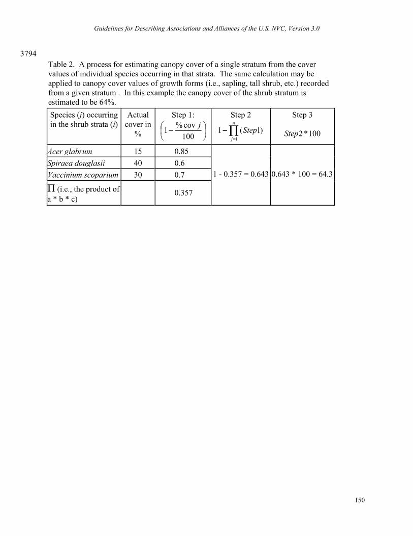
Guidelines for Describing Associations and Alliances of the U.S. NVC, Version 3.0
150
3794 Table 2. A process for estimating canopy cover of a single stratum from the cover values of individual species occurring in that strata. The same calculation may be applied to canopy cover values of growth forms (i.e., sapling, tall shrub, etc.) recorded from a given stratum . In this example the canopy cover of the shrub stratum is estimated to be 64%. Species (j) occurring in the shrub strata (i)
Actual cover in
%
Step 1:
−
100cov%1 j
Step 2
∏=
−n
j
Step1
)1(1
Step 3
100*2Step
Acer glabrum 15 0.85Spiraea douglasii 40 0.6Vaccinium scoparium 30 0.7
Π (i.e., the product of a * b * c)
0.357
1 - 0.357 = 0.643 0.643 * 100 = 64.3

The Ecological Society of America, Vegetation Classification Panel
151
Table 3. Recommended growth forms to be used when describing vegetation structure (see also 3795 Whittaker 1975:359, and Table 1.2 of Appendix 1). Not to be confused with vegetation strata. 3796
Tree Trees (larger woody plants, mostly well above 5 m tall) Needle-leaved tree (mainly conifers – pine, spruce, larch, redwood, etc.) Broad-leaved deciduous tree (leaves shed in the temperate zone winter, or in the
tropical dry season) Broad-leaved evergreen tree (many tropical and subtropical trees, mostly with
medium-sized leaves) Thorn tree (armed with spines, in many cases with compound, deciduous leaves,
often reduced in size) Evergreen sclerophyllous tree (with smaller, tough, evergreen leaves) Succulent tree (primarily cacti and succulent euphorbs) Palm tree (rosette trees, unbranched with a crown of large leaves) Tree fern (rosette trees, unbranched with a crown of large leaves) Bamboo (arborescent grasses with woody-like stems) Other tree
Shrub Shrubs (smaller woody plants, mostly below 5 m tall) Needle-leaved shrub (mainly conifers – juniper, yew, etc.) Broad-leaved deciduous shrub (leaves shed in the temperate zone winter, or in the
tropical dry season) Broad-leaved evergreen shrub (many tropical and temperate shrubs, mostly with
medium to small-sized leaves) Thorn shrub (armed with spines, in many cases with compound, deciduous leaves,
often reduced in size) Evergreen sclerophyllous shrub (with smaller, tough, evergreen leaves) Palm shrub (rosette shrubs, unbranched with a short crown of leaves) Dwarf-shrub (low shrubs spreading near the ground surface, less than 50 cm high) Semi-shrub (suffrutescent, i.e., with the upper parts of the stems and branches dying
back in unfavorable seasons) Succulent shrub (cacti, certain euphorbias, etc.) Other shrub
Herbaceous Herbs (plants without perennial aboveground woody stems) Forb (herbs other than ferns and graminoids) Graminoid (grasses, sedges, and other grass like plants) Fern (pteridophytes –ferns, clubmosses, horsetails, etc.) Succulent forb Aquatic herb (floating & submergent) Other herbaceous
Nonvascular Moss Liverwort/hornwort Lichen Alga

Guidelines for Describing Associations and Alliances of the U.S. NVC, Version 3.0
152
Other Epiphyte (plants growing wholly above the ground surface on other plants) Vine/liana (woody climbers or vines) Other/unknown (null) – Not assessed Aquatic floating Aquatic submerged
3797

The Ecological Society of America, Vegetation Classification Panel
153
3798
Table 4. Comparison of commonly used cover-abundance scales in the United States. Agencies 3799 and authors are abbreviated as: BB=Braun-Blanquet (1928); NC=North Carolina Vegetation 3800 Survey (Peet et al. 1998); K=Domin sensu Krajina (1933); DAUB=Daubenmire (1959); FS 3801 (Db)=Forest Service, modified Daubenmire (1959) scale; PA=Pfister and Arno (1980); 3802 NZ=New Zealand LandCare (Allen 1992, Hall 1992); BDS=Barkman et al. (1964); D=Domin 3803 (1928); FS (eco) = Hann et al. (1988), Keane et al. (1990) for the U.S. Forest Service 3804 ECODATA software). Break points shown in the Cover-abundance column reflect the major 3805 break points of the Braun-Blanquet scale, which is considered the minimum standard for cover 3806 classes. Among the available cover class systems, the NC and K cover class systems can be 3807 unambiguously collapsed to the B-B standard, and the DAUB, FS, PA and NZ scales are for all 3808 practical purposes collapsible into the B-B scale without damage to data integrity. The D, BDS, 3809 WHTF are somewhat discordant with the B-B standard and should be avoided except when 3810 required for incorporation of legacy data. 3811
Cover-abundance BB NC K DAUB FS(Db) PA NZ BDS D FS(eco)Present but not in plot ( )† + Single individual r 1 + 1 T T 1 - + 1 Sporadic or few + 1 1 1 T T 1 - 1 1 0 - 1% 1‡ 2 2 1 T T 1 - 2 1 1 - 2% 1 3 3 1 1 1 2 - 3 3 2 - 3% 1 4 3 1 1 1 2 0 3 3 3 - 5% 1 4 3 1 1 1 2 0 4 3 5 - 6.25% 2 5 4 2 2 2 3 1 4 10 6.25 – 10% 2 5 4 2 2 2 3 1 4 10 10 – 12.5% 2 6 5 2 2 2 3 1 5 10 12.5 – 15% 2 6 5 2 2 2 3 1 5 10 15 – 25% 2 6 5 2 2 2 3 2 5 20 25 – 30% 3 7 6 3 3 3 4 3 6 30 30 – 33% 3 7 6 3 3 3 4 3 6 30 33 – 35% 3 7 7 3 3 3 4 3 7 30 35 – 45% 3 7 7 3 3 3 4 4 7 40 45 – 50% 3 7 7 3 3 3 4 5 7 50 50 – 55% 4 8 8 4 4 4 5 5 8 50 55 – 65% 4 8 8 4 4 4 5 6 8 60 65 – 75% 4 8 8 4 4 4 5 7 8 70 75 – 85% 5 9 9 5 5 5 6 8 9 80 85 – 90% 5 9 9 5 5 5 6 9 9 90 90 – 95% 5 9 9 5 5 5 6 9 10 90 95 – 100% 5 10 10 6 6 6 6 10 10 98
† Species present in the stand but not in the plot are usually added in parentheses to the species list. ‡ This is a cover/abundance scale; if numerous individuals of a taxon collectively contribute less than 5%
cover, then the taxon can be assigned a value of 1 or, if very sparse, a “+.”

Guidelines for Describing Associations and Alliances of the U.S. NVC, Version 3.0
154
3812
3813
Table 5. Summary of vegetation layer, or strata, data from field plots for a given type. 3814
Layer Height Class
Average % Cover
Minimum % Cover
Maximum % Cover
Tree Shrub Herb Moss Floating Aquatic Submerged Aquatic
3815
3816

The Ecological Society of America, Vegetation Classification Panel
155
Table 6. A stand table of floristic composition for each stratum. Strata are defined on page 41. 3817
Species Name
Stratum 1, Dominant 2, Characteristic 3. Constant
Constancy
Av. % Cover
Min. % Cover
Max. % Cover
Species 1 Species 2 Species 3 Species n
3818
3819

Guidelines for Describing Associations and Alliances of the U.S. NVC, Version 3.0
156
Table 7. Constancy classes. 3820 3821
3822
3823
3824
Constancy Classes Relative (%) Constancy
I 1-20
II >20-40
III >40-60
IV >60-80
V >80-100

The Ecological Society of America, Vegetation Classification Panel
157
FIGURES 3825
3826
Figure 1. Categories and examples of the National Vegetation Classification, showing the 3827 levels from class to association. 3828
Figure 2. An illustration of strata showing growth forms of individual plants. 3829
Figure 3. Schematic diagram of the peer review process. 3830
Figure 4. Flow of information through the process for formal recognition of an association or 3831 alliance. 3832
3833

Guidelines for Describing Associations and Alliances of the U.S. NVC, Version 3.0
158
Figure 1. Categories and examples of the National Vegetation Classification, showing the levels 3834 from Class to Association. The FGDC (1997) standard also includes two higher levels above 3835 Class: Division and Order. 3836
3837
Physiognomic Categories 3838
Category . . . .Example 3839
Class . . . .Open Tree Canopy 3840
Subclass . . . .Evergreen Open Tree Canopy 3841
Group . . . . .Temperate or Subpolar Needle-leaved Evergreen Open Tree Canopy 3842
Subgroup . . . .Natural/Seminatural 3843
Formation . . . . Rounded-crowned temperate or subpolar needle-leaved 3844 evergreen open tree canopy. 3845
3846
Floristic Categories 3847
Alliance . . . .Juniperus occidentalis Woodland Alliance 3848
Association . . . . Juniperus occidentalis /Artemesia tridentata 3849 Association 3850
3851
3852
3853
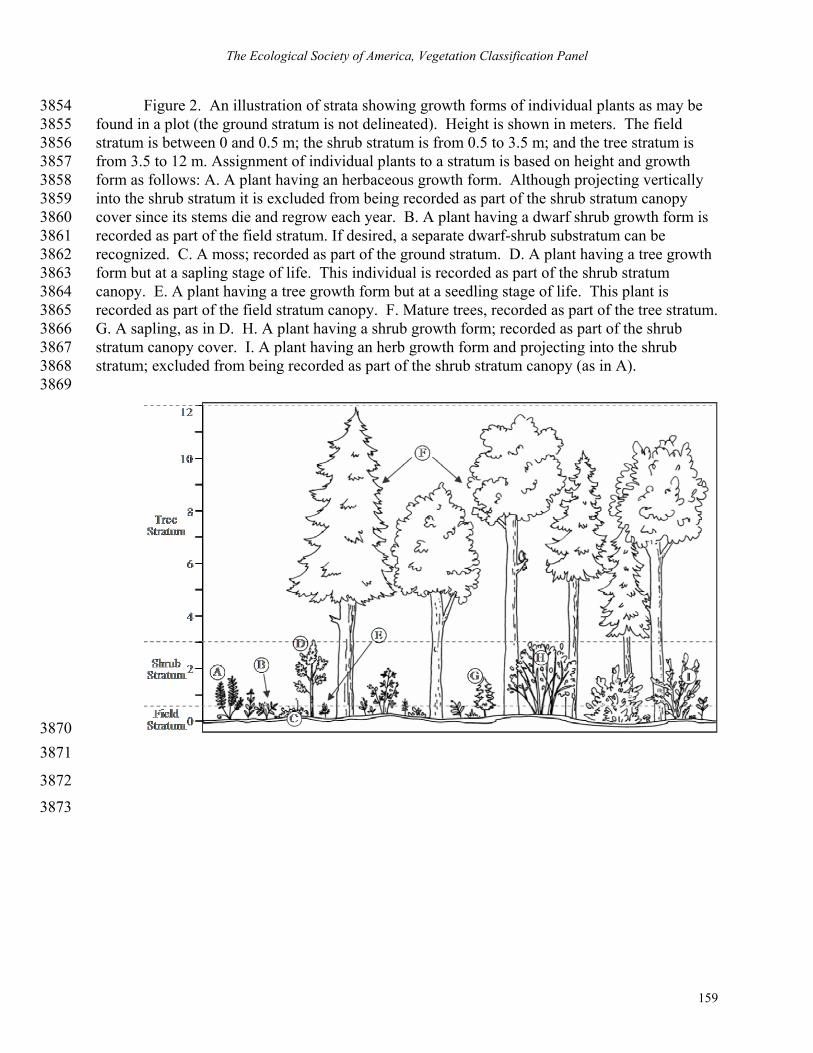
The Ecological Society of America, Vegetation Classification Panel
159
Figure 2. An illustration of strata showing growth forms of individual plants as may be 3854 found in a plot (the ground stratum is not delineated). Height is shown in meters. The field 3855 stratum is between 0 and 0.5 m; the shrub stratum is from 0.5 to 3.5 m; and the tree stratum is 3856 from 3.5 to 12 m. Assignment of individual plants to a stratum is based on height and growth 3857 form as follows: A. A plant having an herbaceous growth form. Although projecting vertically 3858 into the shrub stratum it is excluded from being recorded as part of the shrub stratum canopy 3859 cover since its stems die and regrow each year. B. A plant having a dwarf shrub growth form is 3860 recorded as part of the field stratum. If desired, a separate dwarf-shrub substratum can be 3861 recognized. C. A moss; recorded as part of the ground stratum. D. A plant having a tree growth 3862 form but at a sapling stage of life. This individual is recorded as part of the shrub stratum 3863 canopy. E. A plant having a tree growth form but at a seedling stage of life. This plant is 3864 recorded as part of the field stratum canopy. F. Mature trees, recorded as part of the tree stratum. 3865 G. A sapling, as in D. H. A plant having a shrub growth form; recorded as part of the shrub 3866 stratum canopy cover. I. A plant having an herb growth form and projecting into the shrub 3867 stratum; excluded from being recorded as part of the shrub stratum canopy (as in A). 3868
3869
3870 3871
3872
3873

Guidelines for Describing Associations and Alliances of the U.S. NVC, Version 3.0
160
Figure 3. Schematic diagram of the peer-review process. 3874
3875
3876
3877
3878
3879
3880
3881
3882
3883
3884
3885
3886
3887
3888
1. High confidence types (Level 1) A. Quantitative analysis B. High quality classification plots C. Sufficient geographic and habitat
coverage D. Full peer review
2. Moderate confidence types (Level 2) A. Not sufficiently quantitative or B. Not sufficiently broad
geographically C. High quality classification plots D. Full peer review
The National Vegetation
3. Low confidence types (Level 3) A. Mostly qualitative B. Local studies C. Expedited peer review
Initial NVC types
Investigators
Expedited Peer Review
Proposals 1. New types 2. Revisions of types 3. Promotion of a type’s confidence level

The Ecological Society of America, Vegetation Classification Panel
161
Figure 4. Flow of information through the process for formal recognition of an association or 3889 alliance. Beginning at the top, field plot data are collected, plot data are submitted to the plots 3890 database (VegBank), data are analyzed, and a proposal describing a type is submitted for review. 3891 If accepted by reviewers, the type description is classified under the NVC, the monograph is 3892 published, and the description made available. 3893
3894
Vegetation Classification Process
Output
Proceedings
Field Plot Data
Peer Review
Submission of Plot Data
VegBank
Analysis & Synthesis
Type Proposal
NVC Database
Entity with Web Interface
An Action
An Entity
Legend

Guidelines for Describing Associations and Alliances of the U.S. NVC, Version 3.0
162
3895
TEXT BOXES 3896
Text Box 1. Guiding principles of the FGDC National Vegetation Classification Standard 3897 (FGDC 1997). 3898
Text Box 2. Required topical sections for monographic description of alliances and associations. 3899
Text Box 3. Examples of Association and Alliance names. 3900

The Ecological Society of America, Vegetation Classification Panel
163
Text Box 1. Guiding principles of the FGDC Vegetation Classification Standard (FGDC 1997).
• The classification is applicable over extensive areas.
• The vegetation classification standard compatible, wherever possible, with other Earth cover/land cover classification standards.
• The classification will avoid developing conflicting concepts and methods through cooperative development with the widest possible range of individuals and institutions.
• Application of the classification must be repeatable and consistent.
• When possible, the classification standard will use common terminology (i.e., terms should be understandable, and jargon should be avoided).
• For classification and mapping purposes, the classification categories were designed to be mutually exclusive and additive to 100% of an area when mapped within any of the classification’s hierarchical levels (Division, Order, Class, Subclass, Subgroup, Formation, Alliance, or Association). Guidelines have been developed for those instances where placement of a floristic unit into a single physiognomic classification category is not clear. Additional guidelines will be developed as other such instances occur.
• The classification standard will be dynamic, allowing for refinement as additional information becomes available.
• The NVCS is of existing, not potential, vegetation and is based upon vegetation condition at the optimal time during the growing season. The vegetation types are defined on the basis of inherent attributes and characteristics of the vegetation structure, growth form, and cover.
• The NVCS is hierarchical (i.e., aggregatable) to contain a small number of generalized categories at the higher level and an increasingly large number of more detailed categories at the lower levels. The categories are intended to be useful at a range of scales (UNEP/FAO 1995, Di Gregorio and Jansen 1996).
• The upper levels of the NVCS are based primarily on the physiognomy (life form, cover, structure, leaf type) of the vegetation (not individual species). The life forms (e.g., herb, shrub, or tree) in the dominant or uppermost stratum will predominate in the classification of the vegetation type. Climate and other environmental variables are used to help organize the standard, but physiognomy is the driving factor.
• The lower levels of the NVCS are based on actual floristic (vegetation) composition. The data used to describe Alliance and Association types must be collected in the field using standard and documented sampling methods. The Alliance and Association units are derived from these field data. These floristically-based classes will be nested under the physiognomic classes of the hierarchy.

Guidelines for Describing Associations and Alliances of the U.S. NVC, Version 3.0
164
3901
Text Box 2. Required topical sections for monographic description of alliances and associations.
OVERVIEW
1. Proposed names of the type (Latin, translated, common). 2. Floristic unit (alliance or association). 3. Placement in hierarchy. 4. A brief description of the overall type concept. 5. Classification comments. 6. Rationale for nominal species.
VEGETATION
7. Physiognomy and structure. 8. Floristics. 9. Dynamics.
ENVIRONMENT
10. Environment description. DISTRIBUTION
11. A description of the range/distribution. 12. A list of U.S. states and Canadian provinces where the type occurs or may occur.13. A list of any nations outside the U.S. and Canada where the type occurs or may
occur. PLOT SAMPLING AND ANALYSIS
14. Plots used to define the type. 15. Location of archived plot data. 16. actors affecting data consistency. 17. The number and size of plots. 18. Methods used to analyze field data and identify the type.
a. Details of the methods used to analyze field data. b. Criteria for defining the type.
CONFIDENCE LEVEL
19. Overall confidence level for the type (see Section 7). CITATIONS
20. Synonymy 21. Full citations for any sources 22. Author of Description
DISCUSSION
23. Possible sub-association or -alliance types or variants, if appropriate, should be discussed here along with other narrative information.
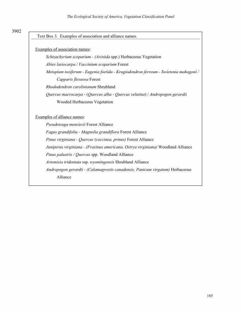
The Ecological Society of America, Vegetation Classification Panel
165
3902 Text Box 3. Examples of association and alliance names.
Examples of association names:
Schizachyrium scoparium - (Aristida spp.) Herbaceous Vegetation
Abies lasiocarpa / Vaccinium scoparium Forest
Metopium toxiferum - Eugenia foetida - Krugiodendron ferreum - Swietenia mahagoni /
Capparis flexuosa Forest
Rhododendron carolinianum Shrubland
Quercus macrocarpa - (Quercus alba - Quercus velutina) / Andropogon gerardii
Wooded Herbaceous Vegetation
Examples of alliance names:
Pseudotsuga menziesii Forest Alliance
Fagus grandifolia - Magnolia grandiflora Forest Alliance
Pinus virginiana - Quercus (coccinea, prinus) Forest Alliance
Juniperus virginiana - (Fraxinus americana, Ostrya virginiana) Woodland Alliance
Pinus palustris / Quercus spp. Woodland Alliance
Artemisia tridentata ssp. wyomingensis Shrubland Alliance
Andropogon gerardii - (Calamagrostis canadensis, Panicum virgatum) Herbaceous
Alliance