guide to zoning categories - mncppcapps.org to zoning... · guide to zoning categories prince...
TRANSCRIPT

GUIDE TOZONING
CATEGORIESPRINCE GEORGE’S COUNTY, MARYLAND
THE MARYLAND-NATIONAL CAPITAL PARK AND PLANNING COMMISSION
PRINCE GEORGE’S COUNTY PLANNING DEPARTMENT
COUNTY ADMINISTRATION BUILDING
14741 GOVERNOR ODEN BOWIE DRIVE
UPPER MARLBORO, MARYLAND 20772
Phone number 301-952-3195
Web Address: www.pgplanning.org
November 2010

RESIDENTIAL ZONES 1
R-O-S: Reserved Open Space - Provides for permanent maintenance of certain areas of land in an un-developed state, with the consent of the property owners; encourages preservation of large areas of trees and open space; designed to protect scenic and environmentally sensitive areas and ensure retention of land for nonintensive active or passive recreational uses; provides for very low density residential development and a limited range of public, recreational, and agricultural uses.
Minimum lot size - 20 acres* Maximum dwelling units per net acre - 0.05 * Except for public recreational uses, for which no minimum area is required. O-S: Open Space - Provides for areas of low-intensity residential (5 acre) development; promotes the
economic use and conservation of land for agriculture, natural resource use, large-lot residential estates, nonintensive recreational use.
Standard lot size - 5 acres Maximum dwelling units per net acre - 0.20 R-A: Residential-Agricultural - Provides for large-lot (2 acre) residential uses while encouraging the re-
tention of agriculture as a primary land use. Standard lot size - 2 acres Maximum dwelling units per net acre - 0.50 R-E: Residential-Estate - Permits large-lot estate subdivisions containing lots approximately one acre or
larger. Standard lot size - 40,000 sq. ft. Maximum dwelling units per net acre - 1.08 Estimated average dwelling units per acre - 0.85
1 Definitions: Minimum or Standard lot size: The current minimum net contiguous land area required for
a lot. Average dwelling units per acre: The number of dwelling units which may be built on a
tract--including the typical mix of streets, public facility sites and areas within the 100-year floodplain--expressed as a per-acre average.
Maximum dwelling units per net acre: The number of dwelling units which may be built
on the total tract--excluding streets and public facility sites, and generally excluding land within the 100-year floodplain--expressed as a per-acre average.

R-R: Rural Residential - Permits approximately one-half-acre residential lots; subdivision lot sizes depend on date of recordation; allows a number of nonresidential special exception uses.
Standard lot size - 20,000 sq. ft. - 15,000 sq. ft. if recorded prior to February 1,
1970 10,000 sq. ft. if recorded prior to July 1, 1967 Maximum dwelling units per net acre - 2.17 Estimated average dwelling units per acre - 1.85 R-80: One-Family Detached Residential - Provides for variation in the size, shape, and width of sub-
division lots to better utilize the natural terrain and to facilitate planning of single-family de-velopments with lots and dwellings of various sizes and styles.
Standard lot size - 9,500 sq. ft. Maximum dwelling units per net acre - 4.5 Estimated average dwelling units per acre - 3.4 R-55: One-Family Detached Residential - Permits small-lot residential subdivisions; promotes high
density, single-family detached dwellings. Standard lot sizes - 6,500 sq. ft. Maximum dwelling units per net acre - 6.70 Estimated average dwelling units per acre - 4.2 R-35: One-Family Semidetached, and Two-Family Detached, Residential - Provides generally for
single-family attached development; allows two-family detached; Detailed Site Plan approval required for lots served by private rights-of-way.
Standard lot sizes - 3,500 sq. ft. for one-family, semi-detached - 7,000 sq. ft. for two-family, detached Maximum dwelling units per net acre - 12.44 Estimated average dwelling units per acre - 8.5 R-20: One-Family Triple-Attached Residential - Permits single-family detached, semidetached and
triple-attached and townhouse development. Detailed Site Plan approval required for town-houses.
Standard lot sizes - 3,200 sq. ft. for end lots - 2,000 sq. ft. for interior townhouse lots Maximum triple-attached dwellings per net acre - 16.33

Maximum townhouses per net acre - 6.0 (same as R-T) Estimated average triple-attached dwelling units per net acre - 11 R-T: Townhouse - Permits one-family detached and attached, two-family, and three-family dwellings;
promotes the maximum amount of freedom in the design of attached dwellings and their grouping and layout; Detailed Site Plan approval required for attached dwellings.
Standard lot size per attached dwelling - 1,800 sq. ft. Maximum dwelling units per net acre - Three-family dwellings - 9 - Two-family dwellings - 8 - Other attached dwellings - 6 Minimum area for development - 2 acres R-30: Multifamily Low Density Residential - Provides for low density garden apartments; sin-
gle-family detached; single-family attached, two-family and three-family dwellings in accor-dance with R-T Zone provisions; Detailed Site Plan approval required for multifamilly and at-tached dwellings.
Standard lot size - Garden apartments - 14,000 sq. ft. - Two-family dwellings - 1,500 sq. ft. - Other attached dwellings - 1,800 sq. ft. Maximum dwelling units per net acre - Garden apartments - 10 - Three-family dwellings - 9 - Two-family dwellings - 8 - Other attached dwellings - 6 R-30C: Multifamily Low Density Residential-Condominium - Same as R-30 above except ownership
must be condominium, or development in accordance with the R-T Zone; Detailed Site Plan approval required for multifamily and attached dwellings.
Standard lot size - Garden apartments - 14,000 sq. ft. - Two-family dwellings - 1,500 sq. ft. - Other attached dwellings - 1,800 sq. ft. Maximum dwelling units per net acre - Garden apartments - 12 - Three-family dwellings - 9 - Two-family dwellings - 8 - Other attached dwellings - 6 R-18: Multifamily Medium Density Residential - Provides for multiple family (apartment) develop-
ment of moderate density; single-family detached; single-family attached, two-family and three-family dwellings in accordance with R-T Zone provisions; Detailed Site Plan approval required for multifamily and attached dwellings.
Standard lot size - Apartments - 16,000 sq. ft. - Two-family dwellings - 1,500 sq. ft. - Other attached dwellings - 1,800 sq. ft.

Maximum dwelling units per net acre - Garden apartments and three-family dwel-lings - 12
- Mid-rise apartments (4 or more stories with elevator) - 20
- Three-family dwellings - 9 - Two-family dwellings - 8 - Other attached dwellings - 6 R-18C: Multifamily Medium Density Residential-Condominium - Same as above except ownership
must be condominium, or development in accordance with the R-T Zone; Detailed Site Plan approval required for multifamily and attached dwellings.
Standard lot size - Apartments - 1 acre - Two-family dwellings - 1,500 sq. ft. - Other attached dwellings - 1,800 sq. ft. Maximum dwelling units per net acre - Garden apartments - 14 - Mid rise apartments (4 or more stories with
elevator) - 20 - Three-family dwellings - 9 - Two-family dwellings - 8 - Other attached dwellings - 6 R-10A: Multifamily, High Density Residential-Efficiency - Provides for a multifamily zone designed for
the elderly, singles, and small family groups. Detailed Site Plan approval required for buildings 110 feet in height or less; special exception required for buildings over 110 feet in height.
Minimum lot size - 2 acres Maximum dwelling units per net acre - 48 plus one for each 1,000 sq. ft. of indoor
common area for social, recreational, or educational purposes. R-10: Multifamily High Density Residential - Provides for suitable sites for high density residential in
proximity to commercial and cultural centers; also permits single-family detached dwellings. Detailed Site Plan approval required for buildings 110 feet in height or less; special exception required for buildings over 110 feet in height.
Minimum lot size - 20,000 sq. ft. Maximum dwelling units per net acre - 48 R-H: Multifamily High-Rise Residential - Provides for suitable sites for high density, vertical resi-
dential development; also permits single-family detached dwellings; Detailed Site Plan approval required for multifamily dwellings.
Minimum lot size - 5 acres Maximum dwelling units per net acre - 48.4

MIXED USE/PLANNED COMMUNITY ZONES
M-X-C: Mixed Use Community - Provides for a comprehensively planned community with a balanced mix of residential, commercial, light manufacturing, recreational and public uses; includes a multistep review process to assure compatibility of proposed land uses with existing and pro-posed surrounding land uses, public facilities and public services; mandates that each devel-opment include residential uses, community use areas, neighborhood centers and an integrated public street system with a variety of street standards.
Minimum tract size - 750 gross acres Lot size and dwelling types - No Restrictions Maximum dwelling units per gross acre - 2 Maximum floor area ratio for commercial uses - 0.4 M-X-T: Mixed Use - Transportation Oriented - Provides for a variety of residential, commercial, and
employment uses; mandates at least two out of the following three use categories: (1) Retail businesses; (2) Office/ Research/Industrial; (3) Dwellings, hotel/motel; encourages a 24-hour functional environment; must be located near a major intersection or a major transit stop or station and will provide adequate transportation facilities for the anticipated traffic or at a loca-tion for which the applicable Master Plan recommends mixed uses similar to those permitted in the M-X-T Zone.
Lot size and dwelling types - No Restrictions Maximum floor area ratio - 0.4 without optional method; - 8.0 with optional method (provision of
amenities) M-U-TC: Mixed-Use Town Center - Provides for a mix of commercial and limited residential uses which
establish a safe, vibrant, 24-hour environment; designed to promote appropriate redevelopment of, and the preservation and adaptive reuse of selected buildings in, older commercial areas; establishes a flexible regulatory framework, based on community input, to encourage compati-ble development and redevelopment; mandates approval of a Development Plan at the time of zoning approval, that includes minimum and maximum Development Standards and Guidelines, in both written and graphic form, to guide and promote local revitalization efforts; provides for legally existing buildings to be expanded or altered, and existing uses for which valid permits have been issued to be considered permitted uses, and eliminating nonconforming building and use regulations for same.
M-U-I: Mixed-Use Infill - Promotes Smart Growth principles by encouraging the efficient use of land,
public facilities and services in areas that are substantially developed. These regulations are intended to create community environments enhanced by a mix of residential, commercial, re-creational, open space, employment and institutional uses in accordance with approved plans. The infill zone may only be approved for property located in a Transit District Overlay Zone or a Development District Overlay Zone.

R-P-C: Planned Community - Provides for a combination of uses permitted in all zones, to promote a large-scale community development with a full range of dwellings providing living space for a minimum of 500 families; encourages recreational, commercial, institutional, and employment facilities within the planned community; requires conformance with an Official Plan identifying zoning subcategories, that has been adopted by the Planning Board following approval of a Final Plan by the District Council at the time of rezoning, and for certain R-P-C Zones, approval of a Detailed Site Plan prior to development.
Lot size and dwelling types - Varied Maximum dwelling units per gross acre - 8 R-M-H: Planned Mobile Home Community - Provides for suitable sites for planned mobile home
communities, including residences and related recreational, commercial, and service facilities, subject to Detailed Site Plan approval.
Minimum lot size - 4,000 sq. ft. Maximum mobile homes per acre - 7 UC-1: Metropolitan Urban Center District – mandates high intensity, transit-oriented,
mixed-use development in General Plan-designated metropolitan centers. These centers are intended for a large-scale mix of uses comprised of multiple Urban Neighborhoods, and are to be the most intense and least auto-dependent areas in Prince George’s County. The Metropolitan Urban Center District is best described as a “downtown” district in ultimate built character. Because of the access to regional fixed-guideway transit systems and the scale of these centers, they are to be primary targets for employment, major educational complexes, and high-intensity commercial uses in the county. The UC Zone may only be approved for property subject to Subtitle 27A of the county code.
UC-2: Regional Urban Center District – mandates moderately-scaled mixed-use, tran-
sit-oriented development generally consisting of two or more Urban Neighborhoods in a town center setting. Regionally marketed commercial and retail centers, office and em-ployment areas, and recreational complexes primarily serving Prince George’s County are appropriate uses. High-density residential development should also be included. The UC Zone may only be approved for property subject to Subtitle 27A of the county code.
UC-3: Community Urban Center District – mandates a small- to moderate-intensity mix of uses
typically developed as a neighborhood “main street” with an adjacent Urban Neigh-borhood. Intended for the least intensive of the General Plan centers, this district shall generally provide a mix of residential and business development to complement and serve existing adjacent neighborhoods. Development may include higher intensity resi-dential and non-residential mixed uses at appropriate locations along key transportation routes. The UC Zone may only be approved for property subject to Subtitle 27A of the county code.
UC-4: Urban Corridor Node – promotes concentrated urban mixed-use, pedestrian-oriented
development with a limited, walkable size at designated locations along General Plan corridors. This district shall generally provide a mix of uses that are smaller in scale to complement and serve existing adjacent neighborhoods. Development may include li-mited higher intensity residential and non-residential mixed uses at appropriate locations

along key transportation routes. Compatibility with existing neighborhoods is essential. The UC Zone may only be approved for property subject to Subtitle 27A of the county code.
COMPREHENSIVE DESIGN ZONES
(These zones require three-phase development plan review, the first of which is Basic Plan approval at the time of rezoning that establishes general land use types, land use relationships, and minimum land use quantities. In zones providing for density and intensity ranges, increases in base density and intensity within the limits prescribed are allowed in return for public benefit features provided by the developer.) R-L: Residential Low Development - Provides for low-density residential development in areas recom-
mended by a Master Plan for alternative low- density development techniques. The zone allows a mixture of residential types and lot sizes generally corresponding to single-family develop-ment; provides for limited commercial uses necessary to serve the dominant residential uses.
Minimum tract size - Generally 100 adjoining gross acres Low .5 - Base density (dwelling units per gross acre) -
.5 - Maximum density - .9 - Maximum mixed retirement development
density - 8 du/gross acre Low 1.0 - Base Density (dwelling units per gross acre) -
1.0 - Maximum density - 1.5 - Maximum mixed retirement development
density - 8 du/gross acre R-S: Residential Suburban Development - A mixture of residential types within the suburban density range
generally corresponding to low-density single-family development; provides for limited commercial uses necessary to serve the dominant residential uses.
Minimum tract size - Generally 25 adjoining gross acres Suburban 1.6 - Base density (dwelling units per gross
acre) - 1.6 - Maximum density - 2.6 - Maximum mixed retirement development
density - 8 du/gross acre Suburban 2.7 - Base density (dwelling units per gross
acre) - 2.7 - Maximum density - 3.5 - Maximum mixed retirement development
density - 8 du/gross acre

R-M: Residential Medium Development - A mixture of residential types with a medium-density range; provides for limited commercial uses necessary to serve the dominant residential uses.
Minimum tract size - Generally 10 adjoining gross acres Medium 3.6 - Base density (dwelling units per gross
acre) - 3.6 - Maximum density - 5.7 - Maximum mixed retirement development
density - 8 du/gross acre Medium 5.8 - Base density (dwelling units per gross
acre) - 5.8 - Maximum density - 7.9 - Maximum mixed retirement development
density - 8 du/gross acre R-U: Residential Urban Development - A mixture of residential types generally associated with an urban
environment; provides for limited commercial uses necessary to serve the dominant residential uses.
Minimum tract size - Generally 5 adjoining gross acres Urban 8.0 - Base density (dwelling units per gross
acre) - 8.0 - Maximum density - 11.9 - Maximum mixed retirement development
density - 8 du/gross acre Urban 12.0 - Base density (dwelling units per gross
acre) - 12.0 - Maximum density - 16.9 - Maximum mixed retirement development
density - 8 du/gross acre L-A-C: Local Activity Center - A mixture of commercial retail and service uses along with comple-
mentary residential densities within a hierarchy of centers servicing three distinct service areas: neighborhood, village, and community.
Neighborhood Village
Community
Minimum tract size 4 adjoining gross ac. 10 adjoining gross ac. 20 adjoining gross ac. Base resid. density 8 du/gross resid. ac. 10 du/gross resid. ac. 10 du/gross resid. ac. Max. resid. density 12.1 du/gross resid. ac. 15 du/gross resid. ac. 20 du/gross resid. ac. Base comm. intensity 0.16 FAR 0.2 FAR 0.2 FAR Max. comm. intensity 0.31 FAR 0.64 FAR 0.68 FAR Max. mixed retirement development density 8 du/gross ac. 8 du/gross ac. 8 du/gross ac.
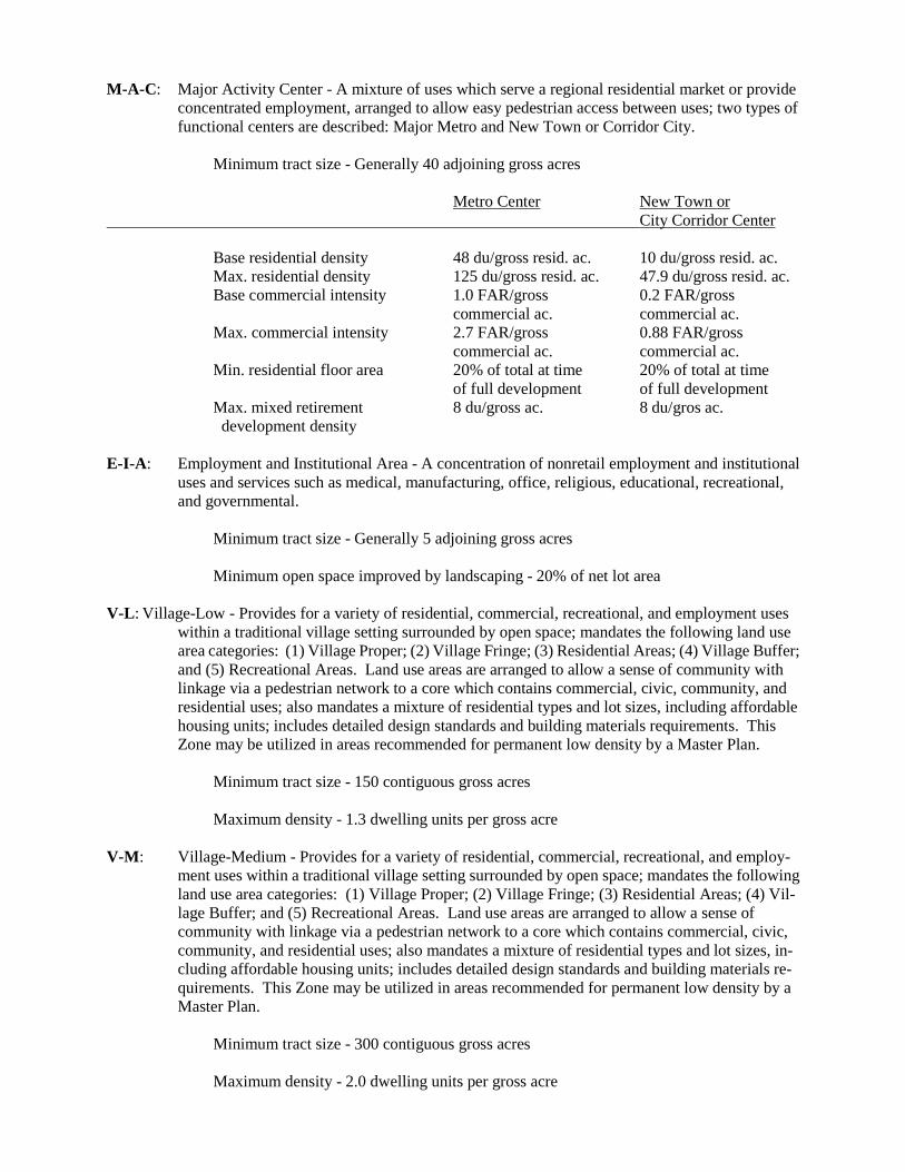
M-A-C: Major Activity Center - A mixture of uses which serve a regional residential market or provide concentrated employment, arranged to allow easy pedestrian access between uses; two types of functional centers are described: Major Metro and New Town or Corridor City.
Minimum tract size - Generally 40 adjoining gross acres Metro Center
New Town or
City Corridor Center
Base residential density 48 du/gross resid. ac. 10 du/gross resid. ac. Max. residential density 125 du/gross resid. ac. 47.9 du/gross resid. ac. Base commercial intensity 1.0 FAR/gross 0.2 FAR/gross commercial ac. commercial ac. Max. commercial intensity 2.7 FAR/gross 0.88 FAR/gross commercial ac. commercial ac. Min. residential floor area 20% of total at time 20% of total at time of full development of full development Max. mixed retirement 8 du/gross ac. 8 du/gros ac. development density E-I-A: Employment and Institutional Area - A concentration of nonretail employment and institutional
uses and services such as medical, manufacturing, office, religious, educational, recreational, and governmental.
Minimum tract size - Generally 5 adjoining gross acres Minimum open space improved by landscaping - 20% of net lot area V-L: Village-Low - Provides for a variety of residential, commercial, recreational, and employment uses
within a traditional village setting surrounded by open space; mandates the following land use area categories: (1) Village Proper; (2) Village Fringe; (3) Residential Areas; (4) Village Buffer; and (5) Recreational Areas. Land use areas are arranged to allow a sense of community with linkage via a pedestrian network to a core which contains commercial, civic, community, and residential uses; also mandates a mixture of residential types and lot sizes, including affordable housing units; includes detailed design standards and building materials requirements. This Zone may be utilized in areas recommended for permanent low density by a Master Plan.
Minimum tract size - 150 contiguous gross acres Maximum density - 1.3 dwelling units per gross acre V-M: Village-Medium - Provides for a variety of residential, commercial, recreational, and employ-
ment uses within a traditional village setting surrounded by open space; mandates the following land use area categories: (1) Village Proper; (2) Village Fringe; (3) Residential Areas; (4) Vil-lage Buffer; and (5) Recreational Areas. Land use areas are arranged to allow a sense of community with linkage via a pedestrian network to a core which contains commercial, civic, community, and residential uses; also mandates a mixture of residential types and lot sizes, in-cluding affordable housing units; includes detailed design standards and building materials re-quirements. This Zone may be utilized in areas recommended for permanent low density by a Master Plan.
Minimum tract size - 300 contiguous gross acres Maximum density - 2.0 dwelling units per gross acre

COMMERCIAL ZONES
C-O: Commercial Office - Uses of a predominantly nonretail commercial nature, such as business, professional and medical offices, or related administrative services.
C-A: Ancillary Commercial - Certain small retail commercial uses, physician and dental offices, and
similar professional offices that are strictly related to and supply necessities in frequent demand and daily needs of an area with a minimum of consumer travel; maximum size of zone: 3 net acres.
C-1: Local Commercial, Existing - All of the uses permitted in the C-S-C Zone. C-2: General Commercial, Existing - All of the uses permitted in the C-S-C Zone, with additions and
modifications. C-C: Community Commercial, Existing - All of the uses permitted in the C-S-C Zone. C-G: General Commercial, Existing - All of the uses permitted in the C-S-C Zone. C-S-C: Commercial Shopping Center - Retail and service commercial activities generally located within
shopping center facilities; size will vary according to trade area. C-H: Highway Commercial, Existing - All of the uses permitted in the C-M Zone. C-M: Commercial Miscellaneous - Varied commercial uses, including office and highway-oriented
uses, which may be disruptive to the compactness and homogeneity of retail shopping centers. C-W: Commercial Waterfront - Marine activities related to tourism, vacationing, boating and sports,
water-oriented recreation, together with limited employment areas which cater to marine activ-ities along a waterfront.
C-R-C: Commercial Regional Center - Provides locations for major regional shopping malls and related
uses that are consistent with the concept of an upscale mall. Minimum area for development - one hundred (100) gross continuous acres; maximum FAR - .75; maximum building height - 75 ft.; maximum building coverage, excluding parking - 50%; Detailed Site Plan approval required.
INDUSTRIAL ZONES
I-1: Light Industrial - Light intensity manufacturing, warehousing, and distribution uses; 10% green area required.
I-2: Heavy Industrial - Highly intensive industrial and manufacturing uses; 10% green area required. I-3: Planned Industrial/Employment Park - Uses that will minimize detrimental effects on residential
and other adjacent areas; a mixture of industrial, research, and office uses with compatible in-stitutional, recreational, and service uses in a manner that will retain the dominant industri-al/employment character of the zone; standard minimum tract size of 25 adjoining gross acres; standard minimum lot size of two acres; Conceptual and Detailed Site Plan approval required; 25% green area required; outdoor uses restricted; warehousing and wholesaling uses limited.

I-4: Limited Intensity Industrial - Limited intensity (0.3 FAR) commercial, manufacturing, ware-housing, and distribution uses; development standards extended to assure limited intensity in-dustrial and commercial development, and compatibility with surrounding zoning and uses; 25% green area required.
U-L-I: Urban Light Industrial - Designed to attract and retain a variety of small-scale light industrial
uses in older, mostly developed industrial areas located close to established residential com-munities; establishes a flexible regulatory process with appropriate standards to promote rein-vestment in, and redevelopment of, older urban industrial areas as employment centers, in a manner compatible with adjacent residential areas.
OVERLAY ZONES2
T-D-O: Transit District Overlay - Intended to ensure that development in a designated district meets the goals established in a Transit District Development Plan. Transit Districts may be designated in the vicinity of Metro stations to maximize transit ridership, serve the economic and social goals of the area, and take advantage of the unique development opportunities which mass transit provides.
D-D-O: Development District Overlay - Intended to ensure that development in a designated district
meets the goals established in a Master Plan, Master Plan Amendment or Sector Plan. Devel-opment Districts may be designated for town centers, Metro areas, commercial corridors, em-ployment centers, revitalization areas, historic areas and other special areas as identified in ap-proved plans.
CHESAPEAKE BAY CRITICAL AREA OVERLAY ZONES3
I-D-O: Intense Development Overlay - To conserve and enhance fish, wildlife, and plant habitats and improve the quality of runoff that enters the Chesapeake Bay, while accommodating existing residential, commercial, or industrial land uses. To promote new residential, commercial and industrial land uses with development intensity limits. Maximum residential density is the same as the underlying zone.
L-D-O: Limited Development Overlay - To maintain and/or improve the quality of runoff entering the
tributaries of the Chesapeake Bay and to maintain existing areas of natural habitat, while ac-commodating additional low-or moderate-intensity development. Maximum residential density is the same as the underlying zone, up to 4.0 du/net acre maximum.
R-C-O: Resource Conservation Overlay - To provide adequate breeding, feeding and wintering habitats
for wildlife, to protect the land and water resources base necessary to support resource-oriented land uses, and to conserve existing woodland and forests for water quality benefits along the tributaries of the Chesapeake Bay. Maximum residential density - .05 du/ gross acre.
REVITALIZATION OVERLAY DISTRICTS4
2These overlay zones are superimposed over other zones, and they may modify provisions of the underlying zones concerning uses allowed and standards for development. In addition, new development is generally subject to ap-proval of a Detailed Site Plan by the Planning Board.
3These overlay zones are superimposed over other zones, and they may modify provisions of the underlying zones concerning uses allowed and standards for development. In addition, new development is generally subject to ap-proval of a Conservation Plan and Conservation Agreement by the Planning Board.

R-O-D: Revitalization Overlay District - Intended to ensure the orderly development or redevelopment
of land within a designated district. Revitalization Districts provide a mechanism for the county to delegate full authority to local municipalities to approve departures from parking, landscaping and sign standards. In addition, limited authority is also delegated for the approval of variances from building setbacks, lot coverage, yards and other dimensional requirements of existing zoning.
ARCHITECTURAL OVERLAY DISTRICTS5
A-C-O: Architectural Conservation Overlay - Intended to ensure that development and redevelopment efforts preserve and protect the architectural or design character of neighborhoods in accordance with an approved Architectural Conservation Plan. Conservation Districts may be designated in areas where the majority of properties have been developed and they exhibit distinct, unifying elements, characteristics, design or other physical features.
4These overlay districts are superimposed over other zones. However, they do not modify provisions of the underlying zones concerning uses allowed and standards for development.
5These overlay zones are superimposed over other zones, and they may modify provisions of the underlying zones concerning design regulations. Howver, they do not modify provisions of the underlying zones concerning allowed uses. In addition, a Detailed Site Plan for Architectural Conservation shall be approved by the Planning Board prior to the issuance of a building or grading permit.