guidance for development of a state-led feasibility … feasibility study guidelines page i final...
TRANSCRIPT

D E PA R T M E N T O F WAT E R R E S O U R C E S F L O O D S Y S T E M M A N A G E M E N T
F I N A L D R A F T D E C E M B E R 2 0 1 4
Guidance for Development of a State-Led Feasibility Study


Guidance for Development of a State-Led Feasibility Study
Final Draft Department of Water Resources
December 2014


State-Led Feasibility Study Guidelines Page i Final Draft
Table of Contents
Table of Contents i
Acronyms iii
Executive Summary 1
1 General Information 1 1.1 Introduction 1 1.2 Need for Preparing Feasibility Study Guidelines 1 1.3 Background 2 1.4 Integrated Water Management 3 1.5 Achieving the State Goals of Public Safety, Environmental
Stewardship, and Economic Stability 4 1.5.1 Public Safety 4 1.5.2 Environmental Stewardship 5 1.5.3 Economic Stability 6
1.6 DWR Investment Priorities 6 1.7 Need for Reconnaissance Studies 6 1.8 Feasibility Study Relationship with CEQA and NEPA Compliance 7
2 DWR Feasibility Study Framework 8 2.1 Overview of the Feasibility Study Process 8 2.2 Step 1 - Identifying Problems and Opportunities 8
2.2.1 Prepare a Scoping Document 8 2.2.2 Describe the Project Area Location, Setting, History, and
Context 9 2.2.3 Describe Problems and Opportunities 10 2.2.4 Planning Goals and Objectives 12 2.2.5 Constraints – Authorities, Legislative Requirements, and
Government Policies & Procedures 13 2.3 Step 2 – Inventorying Present Conditions and Forecasting
Conditions 13 2.4 Step 3 - Formulating Alternative Plans 14 2.5 Step 4 – Evaluating Alternatives 15
2.5.1 Assessing Public Safety Benefits 16 2.5.2 Assessing Economic Stability Benefits 16 2.5.3 Assessing Environmental Stewardship Benefits 17
2.6 Step 5 – Tradeoff Analyses and Selection of Preferred Alternative 19 2.6.1 Public Safety, Environmental Stewardship, and Economic
Stability Benefits 20 2.6.2 Other Considerations in Selection of Preferred Alternative 21

State-Led Feasibility Study Guidelines Page ii Final Draft
3 Report Preparation 22 3.1 Draft Feasibility Study Document 22 3.2 Stakeholders Comments 22 3.3 Final Feasibility Study 23 3.4 Timing and Compatibility with CEQA Process 23
4 Project Financing 24 4.1 Capital Costs 24 4.2 Cost of Operations and Maintenance 25 4.3 Costs of Acquiring Lands, Right-of-Way, and Easements 25 4.4 Cost of Project Development and Permitting 25
5 Environmental Compliance 26 5.1 CEQA 26 5.2 NEPA 27 5.3 Permitting 27
6 Communication and Engagement Plan 30 6.1 Stakeholders Identification, Management, and Outreach 30 6.2 Communications and Engagement Plan 30
6.2.1 Identification of Stakeholders 30 6.2.2 Establish a Stakeholder Technical Work Group 31 6.2.3 Public Meetings 31 6.2.4 Meeting with Key Agencies 31 6.2.5 Other Communication and Engagement Means 32
6.3 Communication and Engagement Schedule 32
7 Project Management Plan 33 7.1 Project Management Environment 33
8 Attachments and Appendices 35 Performance Measures 35
A. The performance of a proposed project considering public safety may include the following: 35
B. The performance of a proposed project considering environmental stewardship may include the following: 35
C. The performance of a proposed project considering economic stability may include the following: 36
Benefits 36 B. Benefits that Foster Environmental Stewardship 38 C. Benefits that Support Economic Stability 39 D. Other Societal Benefits that Result from Water
Management Actions 42

State-Led Feasibility Study Guidelines Page iii Final Draft
Acronyms Basin-Wide Feasibility Study (BWFS) ........................................................................................................................... 24 California Code of Regulations (CCR) ........................................................................................................................... 13 California Department of Finance (DOF) ....................................................................................................................... 14 California Environmental Quality Act (CEQA) ................................................................................................................ 3 California Water Code (CWC) ....................................................................................................................................... 13 Central Valley Flood Protection Board (CVFPB .............................................................................................................. 2 Central Valley Flood Protection Plan (CVFPP) ................................................................................................................ 1 Department of Water Resources (DWR) .......................................................................................................................... 1 Division of Flood Management (DFM) ............................................................................................................................ 1 Environmental Impact Report (EIR) ................................................................................................................................. 1 Environmental Impact Statements (EIS) ........................................................................................................................... 1 Federal Emergency Management Agency (FEMA) ........................................................................................................ 12 Forcasted Based Operation (F-BO) ................................................................................................................................. 20 Forecast Coordination Operation (F-CO) ....................................................................................................................... 20 General Fund (GF) ............................................................................................................................................................ 6 Integrated Water Management (IWM) .............................................................................................................................. 4 National Environmental Policy Act (NEPA) .................................................................................................................... 7 Non-Governmental Entities (NGO) .................................................................................................................................. 6 Present Worth (PW) ........................................................................................................................................................ 17 Project Management Office (PMO) ................................................................................................................................ 33 Project Management Plan (PMP) .................................................................................................................................... 33 Separable Costs-Remaining Benefits (SCRB) ................................................................................................................ 19 State General Obligation Bond (GOB) ............................................................................................................................. 6 State Plan of Flood Control (SPFC) .................................................................................................................................. 2 State System-wide Improvement Authority (SSIA) .......................................................................................................... 1 State Water Project (SWP) .............................................................................................................................................. 13 U.S. Army Corps of Engineers’(USACE) ........................................................................................................................ 1


State-Led Feasibility Study Guidelines Page 1 Final Draft
Executive Summary
This guidance is prepared for the Department of Water Resources (DWR) – Division of Flood Management (DFM) for preparing feasibility studies to reduce flood risks. Feasibility studies look at the viability of projects with an emphasis on identifying potential problems and recommending a practical solution. The outcome of a feasibility study will determine if the identified problems can be addressed and if so how.
Feasibility studies provide details about the various options and determine which option is the best in terms of successfully accomplishing the stated project goals and objectives. Typical information presented in a feasibility study includes:
• Identification of the problems with the existing condition. • Establishment of goals and objectives. • Exploration of various options to alleviate the problems. • Evaluation of each option and selection of the preferred one for implementation. • Engagement of the interested stakeholders; development of strategies to
communicate, engage, and convince the stakeholders that the selected option will serve the State and the community the best.
• Estimation of the efforts, including costs and work schedule, to implement the project.
A feasibility study focuses on the technical and non-technical issues to substantiate the evaluation and the final recommendations leading to the selection of the most efficient and effective option to meet the stated goals and objectives. A feasibility study also includes a financial plan to support implementing key components of potential actions.
This set of guidelines lays out specific expectations and makes recommendations on how to approach and prepare a feasibility study. It briefly discusses the similarities and differences between the State led feasibility study and the U.S. Army Corps of Engineers’(USACE) approach.
Section 1 provides general information on the purpose and need for guidelines and emphasizes the FloodSAFE Program, integrated flood and water management, and the DWR investment strategy as outlined in the Central Valley Flood Protection Plan (CVFPP), State System-wide Improvement Authority (SSIA). It also addresses the State’s overarching interest in achieving an acceptable level of flood protection, environmental stewardship, and economic stability and how to implement projects initiated in partnership with other agencies.
Section 2 describes steps for plan formulation, evaluation, and selection process.
Sections 3 and 4 expand upon the alternative formulation and selection process, providing more detailed guidance on key analytical steps, such as assessing project benefits and conducting tradeoff analyses as part of the alternative selection process.

State-Led Feasibility Study Guidelines Page 2 Final Draft
Section 5 discusses project financing and the costs of completing projects such as capital cost; expenses associated with operations and maintenance and flood emergency response of the projects once implemented; costs associated with lands and right-of-ways and easements.
Section 6 is focused on environmental compliance and permitting.
Section 7 provides outlines for appendices which typically describe the technical foundations for the plan formulation process.

State-Led Feasibility Study Guidelines Page 1 Final Draft
1 General Information
1.1 Introduction
Feasibility studies are the heart of the project planning process. They are designed to help planners identify problems and opportunities, formulate alternative solutions, evaluate them, and select a preferred solution approach in a systematic, effective, and efficient manner. Planning studies that lead to project implementation are generally accompanied by companion reports and documents, such as feasibility studies, environmental impact reports (EIRs), Environmental Impact Statements (EIS), technical appendices, permit applications, and public outreach documentation. Together these documents are decision documents, in that they provide the information, analyses, and arguments needed to support actions such as program implementation, project authorization, funding, permitting, design, and construction.
The successful implementation of a project depends on many factors. The most important factors include:
- Financing: feasibility studies must be accompanied with a reasonable and implementable financing plan
- Agency Alignment: many water resource projects require permitting. Proper environmental documentations and alignment of the agencies during the planning process is needed to ensure support by permitting agencies
- Value assessment: it is critically important to our decision makers and the public to understand the value of a proposed projects, how it helps the wellbeing of the society, its health and safety, its environment and its economy
As we formulate, evaluate and prepare feasibility studies these factors must be considered.
A guiding principle for preparing these decision documents, including feasibility study reports, is that the level of effort be commensurate with the importance, scope, and need. In practice this means that strategic thinking at every stage of the planning process should guide the investment in the study effort at every scale, from the study as a whole down to the formulation of individual measures.
1.2 Need for Preparing Feasibility Study Guidelines
This document is intended to provide DWR staff with guidance on how to conduct State-led feasibility studies, with a focus on facilitating project implementation. The primary focus is on integrated flood risk reduction projects that also achieve multiple benefits, such as enhancement of wildlife and fisheries, recreation, open space, water quality, and water supply reliability. DWR has the primary responsibility for managing the State’s

State-Led Feasibility Study Guidelines Page 2 Final Draft
water resources, and as such, frequently needs to lead or conduct a wide variety of project feasibility studies in order to take appropriate action. While each project poses unique challenges and opportunities, DWR staff can benefit from past experience in conducting feasibility studies. These guidelines provide a concise summation of past experience, both within DWR and other agencies, as well as an understanding of the rapidly changing planning environment. By following these guidelines DWR staff can take advantage of this cumulative knowledge; ensure that new studies are complete and compliant with laws, regulations, and policies; and promote efficiency through standardization of the overall feasibility study approach and structure.
1.3 Background
The typical approach to conducting feasibility studies is very similar to the intuitive approach people in all walks of life use to solve problems. However, water resources planning agencies have structured and refined the feasibility study process over many years of practice, incorporating the experience gained through executing thousands of projects. As the planning environment changes as a result of new legislation, variations in funding, changes in political and social preferences, new scientific and engineering knowledge, and changes in the physical environment, planning procedures must be updated to adapt as well.
In formulating its own feasibility study guidelines there are two good reasons to look first to the federal feasibility study process for guidance. First, federal agencies that conduct feasibility studies are guided by a core set of principles established in 1983 by the Council on Environmental Quality. These are supplemented by planning guidelines established for each agency. USACE is responsible for implementing flood protection, navigation, and environmental restoration projects for the nation. It has developed and refined a rigorous approach to conducting feasibility studies, including an extensive suite of analytical tools to assist in plan formulation.
Second, DWR and the Central Valley Flood Protection Board (CVFPB have partnered over many decades with USACE and local agencies to plan, design, construct, and operate numerous flood risk management projects, including the numerous projects that together comprise the State Plan of Flood Control (SPFC) for the Central Valley. The more closely State feasibility studies are aligned with those prepared by USACE, the more efficiently federal participation can be facilitated. For State-led projects involving repair, modification, or expansion of federally authorized facilities, such alignment is also important for facilitating permitting, federal crediting, and reimbursement.
On the other hand, due to its important national role in executing major, costly civil work projects, including flood protection, navigation, and environmental restoration projects over the past 200 years, USACE has been the focus of intense scrutiny, political pressure, and Congressional activism. The criticism is that the USACE feasibility study process had been very rigorous, heavily laden with detailed, prescriptive guidance, top-down time consuming processes on all stages of the study, and time consuming multiple levels of review. These prescriptions are intended to ensure transparency, accountability,

State-Led Feasibility Study Guidelines Page 3 Final Draft
scientific validity, soundness of engineering, unbiased representation of economic viability, and policy compliance. While these are all important and laudable goals, the downside is that the process became ponderous, expensive, and vulnerable to long delays in execution. Furthermore, some prescriptive guidance, which may have evolved in reaction to issues elsewhere in the nation, may not be applicable to California. USACE has recently instituted the 3x3x3 Rule as part of their Planning Modernization Effort. This requires that feasibility studies cost no more than $3 million, take no more than three years, and have three levels of vertical compliance throughout the process. This 3x3x3 Rule was implemented in 2012 and it is still developing. To date the Non-federal Sponsors have found it difficult to get USACE to emphasize the FloodSAFE Program, integrated flood and water management, and the DWR investment strategy as outlined in the CVFPP, SSIA in the study alternatives.
Even though USACE’s Planning Modernization Effort was to emphasize a system approach and multi benefit solutions, the State has not been able to integrate “system” measures in the alternatives with federal interest and cost share. DWR’s policy is to take a watershed-based or system approach to solving water resources problems, with a greater emphasis on multiple benefits, which requires a more flexible and creative approach than allowed under very stringent federal guidelines.
Therefore, the approach taken in formulating this guidance document is to draw from the federal feasibility study process those elements that are time-tested building blocks, but eschew overly prescriptive or non-applicable elements so that the State process can be effectively applied to systemwide, multiple resource planning efforts while achieving both rigor and speed of execution. While feasibility and planning studies do not require the preparation of an Environmental Impact Report or Negative Declaration for compliance with the California Environmental Quality Act (CEQA) (State CEQA Guidelines CCR Section 15262) they do require consideration of environmental factors. Currently, a joint feasibility studies for projects related to the SPFC facilities includes a joint EIR and EIS. This approach to conduct a project-level analysis presents a challenge for both the State and local agencies which are either the lead or a responsible agency in the CEQA process since feasibility studies are a planning study that are not detailed enough to determine specific impacts on resource areas. The lack of detailed information on the proposed alternatives presented in the feasibility study also pose a challenge for resource agencies who are charged with determining potential impacts on endangered species, air quality and water quality. There are three possible scenarios that could apply to the feasibility study and be satisfactorily to CEQA process; State may use its discretion to determine which scenario is best for individual feasibility studies. The three potential scenarios are 1) a project-level CEQA analysis, 2) a programmatic-level CEQA analysis, and 3) no CEQA analysis.
1.4 Integrated Water Management
On April 3, 2013, DWR hosted an Integrated Water Management Summit, during which it launched the Water 360 campaign to help refocus and strengthen the collective efforts of California’s water management community by advancing Integrated Water
State-Led Feasibility Study Guidelines Page 4 Final Draft
Management (IWM). IWM is a framework for planning and implementation that melds the objectives of improving public safety, fostering environmental stewardship, and supporting environmental stability to lead to sustainable water resource management.
Feasibility studies conducted by DWR staff need to be scoped, structured, and executed such that they advance IWM. DWR managers are expected to consider a broad range of potential benefits when planning and executing projects, including ways to enhance public safety, enhance fisheries and wildlife habitats, improve recreation and open space opportunities, and improve water quality, water supply reliability, power supply, and other potential benefits where feasible. Such considerations should be part of the project implementation process from inception to completion. Full consideration of multiple benefits that can be integrated into a project to improve its value to the people of California is the essence of IWM. Communication and engagement with interested stakeholders is an essential part of this plan formulation process.
Given the growing demands upon limited resources such as water and energy and the challenges posed by climate change, planners must also take into consideration how best to advance long-term sustainability, resiliency, and redundancy through projects implemented by DWR.
1.5 Achieving the State Goals of Public Safety, Environmental Stewardship, and Economic Stability
As DWR prepares feasibility studies, it must seek to advance the following:
• Public Safety – Enhanced public safety, health, and quality of life for the State’s citizens.
• Environmental Stewardship – Protection and enhancement of California’s unique biological diversity, ecological values, and cultural heritage.
• Economic Stability – Sustained economic growth, business vitality, and agricultural productivity.
The overarching goals of public safety, environmental stewardship, and economic stability are discussed in greater detail below.
1.5.1 Public Safety
Floods have had devastating effects on life and property in California, especially in the Central Valley. Minimizing the impacts of floods on lives, property, and assets of the State has been the focus of the DWR FloodSAFE Program. Catastrophic floods in California have been documented since the mid-1800s. The current flood management system in the Central Valley has evolved over several decades and through an incremental learning and construction process. The State flood management systems include levees, bypasses, reservoirs, gate structures, pumping plants, etc. The existing facilities have

State-Led Feasibility Study Guidelines Page 5 Final Draft
been constructed through the individual and combined efforts of local, State, and federal agencies. Many of the original facilities (levees included) were constructed with materials at hand over many decades and therefore lack adequate design standards and construction techniques. As a result, these facilities provide varying levels of protection depending on when and how they were constructed and upgraded. Given the deficiencies in the current flood control system, the system protects a large population, major freeways, railroads, airports, water supply systems, utilities, and other infrastructure of statewide importance; a sustainable and resilient flood management system is needed for California.
In addition to flood control, California’s rivers and floodplains serve as conduits for municipal, industrial, and agricultural water supply, fisheries and wildlife habitat, and recreation; these demands have been increasing as a result of population growth. Although the existing flood management system has prevented billions of dollars in flood damages since its construction, a better understanding of the risk assessment and engineering standards has made it clear that some facilities face a higher than expected chance of failure. Aging infrastructure combined with urbanization in the floodplain areas has increased the level of flood risk, jeopardizing public safety. The performance measures and benefits associated with public safety are discussed in Attachment A.
1.5.2 Environmental Stewardship
On September 21, 2010, DWR formally adopted an Environmental Stewardship Policy (DWR, 2010). It notes that environmental stewardship is a concept and commitment of responsibility to manage and protect natural resources (water, air, land, plants, and animals) and ecosystems in a sustainable manner that ensures they are available for future generations. It notes that the goal of an environmental stewardship ethic is to create human systems consistent with natural systems, where each is ultimately sustainable and systems of water supply and flood protection are more successful when they accommodate and sustain ecosystem functions. Sustainable systems are also more economical over time. Accordingly, DWR managers are directed to embrace environmental stewardship as part of their responsibilities in several ways, including integrating ecosystem protection and restoration into water storage and conveyance and flood management planning efforts.
The ecosystems of river channels, floodplains, and flood basins are among the State’s most important natural resources, providing habitats of critical importance to numerous native aquatic and terrestrial species. These ecosystems have been drastically reduced in size, quality, and connectivity compared to historical conditions, which has negatively impacted the native species that are a part of these ecosystems. Opportunities to address ecological problems and improve its conditions may be identified based on their potential to contribute to the State’s conservation goals and objectives.
DWR policies in water management are working “towards more sustainable, integrated water resources management to provide for a productive economy, healthy ecosystem, and desirable quality of life for all Californians.” The concept is to integrate
State-Led Feasibility Study Guidelines Page 6 Final Draft
environmental requirements in projects and include its benefits in the planning and development of projects. The performance measures and benefits associated with environmental stewardship are discussed in Attachment A.
1.5.3 Economic Stability
Californians enjoy the economic prosperity of the State in which water management, flood protection, transportation, and energy infrastructure play critically important roles. The economic benefits resulting from our water supply, storage, and conveyance facilities have enhanced our way of life and have been fundamental in building California and its economic prosperity. Similarly, California’s flood management infrastructure has made it possible to develop the farms, communities, and infrastructure in floodplains by protecting lives and billions of dollars in assets. A more resilient flood management system is needed to continue enjoying the economic prosperity in the future. The performance measures and benefits associated with economic stability are discussed in Attachment A.
1.6 DWR Investment Priorities
California has a complex water infrastructure system that stores and conveys water, manages flood flows, and interconnects many of the State’s regions. There are many competing demands for improvements in water supply, water quality, flood risk management, fisheries and wildlife habitat quality, hydropower, recreation, and open space.
Funding for improvements in California’s water infrastructure comes from a wide variety of sources, including State General Obligation Bond (GOB) acts, the General Fund (GF), special fees, federal appropriations, local agency funds, and contributions from Non-Governmental Entities (NGO). Often these funding streams are associated with and constrained by specific authorizing language, which limits the ways in which improvement projects can be formulated. In conducting feasibility studies to facilitate water infrastructure improvements, DWR planners must adhere to those constraints when they exist, while at the same time seek to maximize the multiple benefits achievable through investing those funds for the benefit of the people of California. Conversely, some feasibility studies ultimately lead to new authorizations and appropriations, which can be informed by enlightened, systemwide, multi-benefit planning efforts conducted by DWR staff.
1.7 Need for Reconnaissance Studies
A full feasibility study represents a major investment in staff resources. Consistent with the guiding principle of scaling the level of effort to the importance and need for a particular project, a reconnaissance study should be conducted by the State before beginning a full feasibility study. A reconnaissance study takes a strategic approach to assessment of the importance and need for a project, relying on rapid, approximate analyses of existing information. Its primary goal is to determine the extent of the State’s

State-Led Feasibility Study Guidelines Page 7 Final Draft
interest in a project, which will lead to a decision on whether to proceed with a full feasibility study. In some cases, past studies may provide adequate information that can be used in place of the reconnaissance studies. An example would be the 2012 CVFPP that provided the information and rationale needed for conducting two feasibility studies for the facilities of the SPFC in the Central Valley.
1.8 Feasibility Study Relationship with CEQA and NEPA Compliance
Although CEQA section 15162 provides exemption for feasibility studies and only requires consideration of environmental factors in lieu of preparation of an EIR or Negative Declaration, many of the formal steps in the feasibility study process are dictated by existing environmental laws and regulations. The State’s CEQA regulations and federal National Environmental Policy Act (NEPA) regulations are well documented elsewhere and will not be described in detail in this document, but a brief discussion is provided in Section 6 to provide context. Both CEQA and NEPA regulations require that agencies take specific actions throughout the project planning process to ensure adequate notice to other agencies and the interested public, opportunities for meaningful review and comment, disclosure of the responsible agency’s responses to review comments, and ultimately the agency’s decision regarding whether and how to proceed with the project. These steps are summarized in Table 1 of Section 6.

State-Led Feasibility Study Guidelines Page 8 Final Draft
2 DWR Feasibility Study Framework
2.1 Overview of the Feasibility Study Process
The DWR feasibility study follows a five-step process—a structured approach to problem solving that provides a rational framework for decision-making. The five steps are:
Step 1 - Identifying problems and opportunities
Step 2 - Inventorying existing condition and forecasting conditions
Step 3 - Formulating alternatives
Step 4 - Evaluating alternatives
Step 5 – Tradeoff analyses and selection of preferred alternative
This Section summarizes each step. Although the process is described as a linear, sequential process, in reality it is an iterative, interactive process. As more information is acquired and developed, it is often necessary to reiterate some of the previous steps in order to formulate a cost-efficient, multi-benefit integrated plan that meets the State’s objectives.
2.2 Step 1 - Identifying Problems and Opportunities
This step encompasses a discussion of the project area and background, the identification of problems and opportunities, framing of the study objectives, and defining potential constraints. An accurate and complete picture of the problems and opportunities within a study area can only be obtained through communication and engagement with involved agencies and stakeholders. Scoping meetings provide a structured opportunity to inform and receive feedback from those agencies and stakeholders. The scoping process is documented in the Scoping Document.
2.2.1 Prepare a Scoping Document
The scoping document is an integral part of both the feasibility study process and the companion environmental documentation process. The scoping document is the first major document prepared in the feasibility study process. This document is prepared after the scoping meetings to document DWR’s initial evaluation of the problems and opportunities, purpose and need, constraints, project setting, the potential range and magnitude of alternative plans, an initial environmental assessment, the proposed planning process, and initial feedback from involved agencies and interested stakeholders. By publicly describing and responding to the scoping comments, the scoping document encourages further constructive agency and stakeholder involvement.

State-Led Feasibility Study Guidelines Page 9 Final Draft
A scoping document is also recommended under CEQA and required by NEPA unless the anticipated project has less-than-significant environmental impacts and is therefore exempt (CEQA Categorical Exemption or Finding of No Significant Impact under NEPA). In some cases past studies and/or documents may provide adequate information that can be used in place of the scoping document. An example would be the 2012 CVFPP that provided the information, rationale, and extensive public input needed for conducting two feasibility studies for the facilities of the SPFC in the Central Valley.
2.2.2 Describe the Project Area Location, Setting, History, and Context
A feasibility study should provide a brief description of the following, at a minimum.
2.2.2.1 Project Location
A description of the location, including the boundaries of the study area, is required. The information should provide details on the study area, existing facilities, and function of the facilities.
2.2.2.2 Project Setting
Topography, Geology, and Soils
Provide a general discussion of topography, geology, and soils, including a brief discussion of the geologic history of the region, geologic hazards such as earthquake risk and risk of landslides, the origin of regional soil types, and soil quality.
Climate and Hydrology
The feasibility study should briefly address the climate of the project area and discuss the wind, temperature range, a range of runoff amount, and precipitation amount. A greater and more detailed discussion of the climate should be presented in an appendix.
Population, Land Use, and Communities
This section should include the historical trends and distribution of the population in the study area, including the identification of various communities (i.e., urban, small, and agricultural), and existing infrastructures such as housing, highways, roads, railroads, airports, major land uses, recreational facilities, and essential services.
Major Waterways
Given DWR’s focus on integrated water resources management, a description of major and minor watersheds, rivers and streams, levees, floodplains, reservoirs, and other infrastructure are particularly important. The existing risks and benefits associated with these features across the spectrum of IWM should be described to provide context for the discussion of problems, opportunities, and constraints.

State-Led Feasibility Study Guidelines Page 10 Final Draft
Environmental Resources
Changes in environmental resources, history, and trend in resources within the project area should be identified. This should include a summary description of the pre-development conditions, historic actions that changed those conditions, and a summary of current conditions and trends. The CEQA statute and guidelines present the required contents of an environmental document and should be used as a resource.
2.2.2.3 Project Background/History
The project background is important to provide a context for the feasibility study. It is not intended to be encyclopedic; rather, it should describe the regional and historic context for the problems that the feasibility study is to address.
2.2.2.4 Context
Authorities and Mandates
The report should describe the relevant authorities, policies, and regulations that mandate and/or provide the framework for the study. In addition, this section should include a discussion of past studies and projects and how they may have affected existing conditions.
Agencies, Project Beneficiaries, and Stakeholders
The study needs to clearly identify agencies within the projects areas and their roles and responsibilities, and state who are stakeholders and beneficiaries: state, regional, urban, small communities, agricultural. Most DWR projects are completed in partnership with federal and/or local agencies. Each partner needs to be identified and their role in the project clearly discussed. Partnership does not always involve project cost sharing.
2.2.3 Describe Problems and Opportunities
Problems and opportunities statements are framed in terms of State interest and the specific study planning objectives within the framework of IWM. Problems and opportunities should be defined in a manner that does not preclude the consideration of all potential alternatives to solve the problems and achieve the opportunities. Problems and opportunities statements should take into consideration current as well as future conditions and be dynamic in nature. Thus, they can be, and usually are, re-evaluated and modified in subsequent steps and iterations of the planning process.
Properly defined, statements of problems and opportunities will reflect the State’s priorities and preferences, but take into consideration the interests of potential project partners and permitting agencies, including other State, federal, and local agencies. Proper identification of problems and opportunities is the foundation for the planning process. This problem identification step should begin as soon as practicable after the decision to initiate a planning study.
State-Led Feasibility Study Guidelines Page 11 Final Draft
Examples of problems that DWR typically confronts in its feasibility studies include:
• Aging Infrastructure – Our water supply and flood control facilities were built more than 50 years ago and not originally built with current engineering, hydrologic understanding, and geotechnical standards.
• Inadequate Conveyance and Storage – Our current infrastructure does not have adequate capacity to store and convey the system design flows considering changing hydrology and climate change.
• Physical Constraints - Our flood system was designed with limited hydrologic data and in many cases the system is undersized.
• Population Growth - The land use has been changing and as a result more communities are in danger of flooding than before, and consequently in need of higher flood protection. Similarly, the water demand is increasing and more modern facilities are needed.
• Climate change is expected to generate more extreme floods, more seasonal rain, less snow, and rising sea levels. These trends appear to be already well established, and if they continue as expected, they will put increasing stress on the State’s infrastructure. Increased temperatures and altered runoff patterns also directly impact the health of California’s natural ecosystems and habitats. The system capacity issues mentioned above are further exacerbated by the impacts of global climate change.
• Riverine habitats and ecosystem functions have been degraded over time. The geographic extent, quality, and connectivity of native habitats in the Central Valley have all declined.
Opportunities may include new funding streams or authorities, willing sellers for project-significant right-of-way, new management techniques or technologies, and other initiatives.
Depending on the type of the project, and particularly for projects primarily focused on flood risk management, the following technical areas should be considered when identifying problems and opportunities.
2.2.3.1 Hydrology, Hydraulics, and Climate Change
Current hydrologic tools and information, including the likely effects of climate change, should be used to help define problems and opportunities. Similarly, a definition of hydraulic performance issues can be supported by existing sophisticated analytical tools such as HEC-RAS, which is a mathematical modeling tool developed by USACE to estimate channel hydraulic characteristics.

State-Led Feasibility Study Guidelines Page 12 Final Draft
2.2.3.2 Floodplains
This includes existing problems associated with floodplain land uses and the associated risks, as well as opportunities for reducing those risks through a broad range of structural and nonstructural measures.
2.2.3.3 Geotechnical Concerns
This includes a summary description of problems related to existing geological structures that may affect flood risk or the stability of other types of infrastructure, such as highly permeable, compressible, or otherwise dangerous characteristics. Subsequent study activities should incorporate further exploration as necessary to adequately characterize these types of problems.
2.2.3.4 Levees
This may include a summary description of problems such as erosion, degradation, and/or removal of natural berms, animal burrows, settlement, inadequate maintenance, and the buildup of sediment deposits, and, in some areas, loss of channel capacity, lack of public understanding of risks, and so on. Opportunities may include possibly feasible levee setback locations, the potential for improved emergency response, and improved maintenance.
2.2.3.5 Economics
Economic analysis tools such as the USACE Flood Damage Analysis (FDA) program can help characterize the magnitude of flood risk when comparing alternatives and help identify opportunities for limiting or reducing future flood risks.
2.2.3.6 Hazards
This can include a variety of hazards, such as described by local entities under Federal Emergency Management Agency (FEMA) Multi-Hazard Multi-Jurisdictional Mitigation Planning process. Of particular interest are flood risks and flood risk reduction opportunities, which can include both levee and dam failure scenarios, and localized flash flooding. Other hazards, such as the risk of earthquakes, landslides, fire, ice, and tornados may also be relevant to the study and therefore should be discussed.
2.2.3.7 Maintenance Issues
This may include a discussion of fragmentation of responsibilities, increasing costs, regulatory constraints, and problems associated with aging infrastructure reaching the end of its design life.
2.2.4 Planning Goals and Objectives
The defined problems and opportunities lead to formulation of the study planning goals and objectives that will allow DWR to solve those problems, while capitalizing on those

State-Led Feasibility Study Guidelines Page 13 Final Draft
opportunities to maximize multiple benefits and investment efficiency. Goals are broad and general in nature; objectives are more specific and narrowly defined ways to achieve those goals. Planning goals and objectives are statements that describe the desired results of the planning process by solving the problems and taking advantage of the identified opportunities. The planning goals and objectives must be directly related to the problems and opportunities identified for the study and will be used for the formulation and evaluation of plans. They must be clearly defined and provide information on the effect desired (quantified, if possible), the subject of the objective (what will be changed by accomplishing the objective), the location where the expected result will occur, the timing of the effect (when the effect would occur), and the duration of the effect.
The objectives for the feasibility study must be specific and measurable and should reflect the desired outcome of the project. The objectives of any DWR feasibility study needs to be aligned with its commitment to IWM, State interest, DWR policy directions, and any specific goals and objectives established by authorizing or appropriations language for the study.
2.2.5 Constraints – Authorities, Legislative Requirements, and Government Policies & Procedures
Constraints are restrictions that limit the planning process. Constraints, like objectives, are unique to each planning study. Some general types of constraints that need to be considered are resource constraints and legal and policy constraints. Resource constraints are those associated with limits on knowledge, expertise, experience, ability, data, information, money and time. Legal and policy constraints are those defined by laws, applicable policies, regulations, and other types of guidance.
Plans should be formulated to meet the study objectives, take advantage of opportunities, and consider the constraints. Thus, a clear definition of objectives, opportunities, and constraints is essential to the success of the planning process.
The authority, under which a feasibility study is conducted, as well as all relevant policies and procedures, should be clearly described in this section.
Typically, the authority of the projects that DWR initiates or participates in lies under the California Water Code (CWC), California Code of Regulations (CCR), FloodSAFE Initiative, State Water Project (SWP), or some other legislative actions. In addition, federal, State, and local laws, regulations, policies, and permit requirements may constrain the study scope and range of potential solution options.
2.3 Step 2 – Inventorying Present Conditions and Forecasting Conditions
The second step of the planning process is to develop an inventory and forecast of critical resources (physical, demographic, economic, social, etc.) relevant to the problems and opportunities under consideration in the planning area. The planning team uses this

State-Led Feasibility Study Guidelines Page 14 Final Draft
information to further define and characterize the problems and opportunities. The team makes a quantitative and qualitative description of these resources to the extent feasible, for both current and future conditions to define existing and future without-project conditions.
Existing conditions are those at the time the study is initiated. The forecast of the future without-project condition reflects the conditions expected during the period of analysis. The future without-project condition provides the basis to formulating alternative plans and assessing their benefits and impacts. Since impact assessment is the basis for plan evaluation, comparison and selection, clear definition and full documentation of the without-project condition are essential. Gathering information about historic and existing conditions requires an inventory.
Gathering information about potential future conditions requires forecasts, which should be made for selected years over the period of analysis to indicate how changes in economic and other conditions are likely to affect the impact analysis. Information gathering and forecasts will most likely continue throughout the planning process.
Future conditions analyses should include the likely impacts of projected population growth as forecast by the California Department of Finance (DOF), regional economic growth, land use changes, completion of other projects with a high likelihood of implementation, and other reasonably foreseeable trends. Future environmental conditions may be described in terms of changes in climate, water quality, air quality, fisheries and wildlife habitat extent and quality, open space, recreational opportunities, and public health, as well as other potentially relevant criteria.
2.4 Step 3 - Formulating Alternative Plans
Alternative plans should be formulated to identify various ways to achieve the planning objectives, so as to solve the problems and realize the opportunities that were identified in Step 1. An alternative plan consists of a system of structural and/or nonstructural measures, strategies, or programs formulated to meet, fully or partially, the identified study planning objectives subject to the planning constraints.
A management action is a feature or an activity that can be implemented at a specific geographic site to contribute to one or more planning objectives. Management actions are the building blocks of alternative plans and are categorized as structural and nonstructural. Equal consideration must be given to these two categories of actions during the planning process.
An alternative plan includes one or more management actions functioning together to achieve the planning objectives as described above. The team should formulate a range of alternative plans that can then be screened and refined in subsequent iterations throughout the planning process.

State-Led Feasibility Study Guidelines Page 15 Final Draft
The first phase in the plan formulation process is the identification of management actions that could be implemented, giving equal consideration to structural and non-structural measures. Structural actions are facilities such as new or improved levees, dams, pump stations, weirs, and gates. Non-structural actions can include a wide range of actions that can help achieve the plan objectives without constructing or improving facilities, such as incentives, regulations, land use changes, and emergency preparations. Non-structural actions, such as effective floodplain land use regulations, can be very cost-effective tools for achieving plan objectives.
The second phase involves combining the management actions to create alternative plans. The driving concept is to creatively explore the range of possibilities, with an eye toward achieving multiple benefits. In formulating alternative plans, it is essential that the planning team understand and fully visualize the problems of the planning area and how alternative plans can address these problems.
In practice the alternative formulation process also involves developing alternatives that are the bookends that represent by large degree interest of various parties. Then through tradeoff analyses (see Section 2.7) the most reasonable, balanced, and cost-efficient alternative is developed by selecting the reasonable management actions from the bookend alternatives to form an alternative that best achieves multiple benefits, meets project objectives with reasonable cost, and to some degree, represents the interests of all parties.
Appropriate mitigation of adverse effects should be treated as an integral component of each alternative plan, beginning with the formulation phase. Early coordination with resources and permitting agencies can be very helpful in identifying the types and scopes of mitigation that might be necessary. The timing of ecosystem actions implementation is also important, reflecting DWR’s commitment to protecting environmental quality.
Alternative plans should be significantly differentiated from each other and as mentioned earlier should also include bookends.
2.5 Step 4 – Evaluating Alternatives
The evaluation of effects is a comparison of the with-project and without-project conditions for each alternative, either quantitatively or qualitatively. A wide range of measures can be used to complete such a comparison. Given DWR’s commitment to IWM, careful consideration should be given at the outset to creating a sufficiently broad range of measurement criteria (or variables) to fully describe multiple benefits and impacts. While quantitative measurement criteria offer the advantage of being easily compared, it is important to consider the extent to which they fully capture and describe the effects as intended. There is no substitute for well-reasoned and carefully documented analyses.
Criteria to evaluate the alternatives should include all significant resources, outputs, and plan effects (especially the study planning objectives and other criteria important to

State-Led Feasibility Study Guidelines Page 16 Final Draft
participating stakeholders). Analyses conducted for alternative evaluation should be complete, as precise as possible, and concise. The evaluation consists of four general tasks:
• The first task is to forecast the most likely with-project condition expected under each alternative plan.
• The second task is to compare each with-project condition to the without-project condition and document the differences between the two.
• The third task is to characterize the beneficial and adverse effects by magnitude, location, timing, and duration.
• The fourth task is to describe the reasoning leading to identification of the plans that will be further considered in the planning process, based on a comparison of the adverse and beneficial effects and the evaluation criteria.
Steps in the procedures may be abbreviated by reducing the extent of the analysis and amount of data collected where greater accuracy or detail is clearly not justified. On the other hand, the analysis may suggest opportunities for further refinement of alternative plans or changes in configurations to improve the tradeoff between multiple benefits, leading to selection of a preferred alternative.
DWR evaluates water resources development projects in terms of their contributions to all three of the overarching goals of improving public safety, environmental stewardship, and economic stability. Criteria that can help in making these assessments are discussed in the following sections.
2.5.1 Assessing Public Safety Benefits
DWR’s role in public safety is primarily associated with the impacts of flooding. A number of measures of such impacts, and the reductions in such impacts offered by alternative plans, include:
• Flood frequency reduction • Reductions in peak flood flows and duration • Reductions in peak flood stages and duration • Reductions in estimated flood damages, including direct property damage and
economic disruption • Reductions in the number of likely fatalities associated with flooding
Increased flood system flexibility for more effective management of large floods and flood system resiliency are the most important consideration to alternatives of public safety benefits.
2.5.2 Assessing Economic Stability Benefits
An economy with fairly constant growth in output, high employment, a broad distribution of income, and low, stable inflation is generally considered economically stable.

State-Led Feasibility Study Guidelines Page 17 Final Draft
Economic stability is a broad concept, affected by a multitude of factors, of which water resources management is just one subset. Economic costs and benefits are typically expressed in monetary terms. Because the value of money changes over time due to investment return and broad monetary trends such as inflation and deflation, the assumptions underlying the economic analyses must be spelled out carefully.
Costs and benefits that may accrue over the life of a project must be converted to a common time base for comparison. For DWR feasibility studies, all costs and benefits should be converted to Present Worth (PW) before they are tallied. In PW conversions, future costs are discounted to PW using the aggregate State investment rate of return as calculated by DOF. Benefits can be either avoided costs, such as would occur with improved flood protection, or direct increases in revenue, such as would occur with business development and expansion. Within the context of concurrently meeting the State’s overarching goals, the planning team should seek to achieve the greatest benefits while incurring the least costs. The net difference between net benefits and costs is one of the measures of alternative performance.
Water management actions that can help improve statewide and regional economic stability include those that can:
• Reduce expected direct damages and regional economic disruptions caused by flooding.
• Provide adequate flood protection to allow for continuing or expanded economic activities within a region.
• Reduce the likelihood of significant social disruption. • Attract high-quality jobs associated with construction with capital investments in
water resources management infrastructure, which in turn has a ripple effect through the regional economy.
• Reduce long-term costs of flood protection systems and other water management operations and maintenance.
• Improve environmental quality, including air and water quality, fisheries and wildlife habitats, and open space and recreational opportunities, which attracts healthy economic investments.
• Provide for, and protect, reliable water supplies for a variety of beneficial uses that sustain economic activity.
2.5.3 Assessing Environmental Stewardship Benefits
Environmental stewardship is a commitment of responsibility to manage and protect natural resources (water, air, land, plants, and animals) and ecosystems in a sustainable manner that ensures they are available for future generations. Improving environmental stewardship in relation to flood management results from actions that help to:
• Incorporate environmental stewardship principles and methods throughout the entire life cycle (planning, design, permitting, implementation, operation,

State-Led Feasibility Study Guidelines Page 18 Final Draft
maintenance, and reauthorization/replacement) of water-related projects and policies.
• Reduce wasteful or inefficient use of natural resources. • Restore or enhance degraded habitat and promote healthy watershed function.
Environmental stewardship expands and improves the sustainability of natural resources and ecosystems. A wide variety of evaluation measures can be used to help quantify these benefits, including the metrics shown in Appendix A.
Although the benefits of many environmental enhancement measures may be difficult to quantify, the costs associated with implementing those benefits, such as purchasing and developing land for wildlife habitat, may be readily quantified. As part of the plan formulation process the planning team should explore alternative ways to achieve the desired benefits, with the aim of accomplishing them in the most cost-effective manner, while staying consistent with the other project goals and objectives. Other alternative evaluation considerations are discussed below.
To evaluate the public safety benefit of the alternatives, we could evaluate flood risk reduction in terms of improvements in annual exceedance probability calculated by normal hydrologic and hydraulic evaluation tools as a surrogate for a number of public safety benefit criteria, such as life risk, because they are all highly correlated with the chance of flooding.
We need to evaluate the opportunities for incorporating fisheries and wildlife habitat into the major alternative features, taking into consideration effects on conveyance, project costs, fisheries and wildlife benefits, and tradeoffs such as loss of productive agricultural lands and utilities relocations.
We also need to evaluate opportunities to incorporate additional benefits, such as water quality enhancement, groundwater recharge, improved surface water supply storage management, power, open space, and recreation, into the alternative plan. Evaluate the tradeoffs involved when these features are added, in terms of incremental costs and the benefits accrued to the alternative plan, both quantifiable and subjective. Optimize by varying the magnitudes and configurations of features, taking into consideration physical system constraints and stakeholder interests and concerns.
To evaluate the direct and indirect economic benefits of improved flood protection we should use standard analytical tools. The primary benefits are a reduced chance of flooding, with a reduction in both the risk of direct damage to infrastructure and the indirect impact on regional economic activity. Additional economic benefits may be associated with improved environmental quality. Some benefits, such as improved recreational opportunities are readily monetized, the economic benefits of other environmental quality improvements may be subjectively evaluated.

State-Led Feasibility Study Guidelines Page 19 Final Draft
The project alternatives should be rigorously evaluated under current and future no-project conditions, and their performances across the full range of evaluation criteria tabulated and compared.
When a wide range of selection criteria are used, it becomes necessary to assign relative importance to each criterion, which is inevitably a subjective process. Whether such weighting is descriptive or transformed into a mathematical weighting system, it is important to carefully evaluate and disclose the basis for the analysis.
DWR does not recommend a specific approach to the comparison and ranking process. However, the primary guiding principle is to apply sound reasoning and scrupulous fairness in the analysis. The decision process needs to be thoroughly described in a way that expert and lay readers alike can understand the judgments made. The evaluation, comparison, and ranking process can be supported by tabulated data and decision support tools, but these are ultimately not a substitute for well-reasoned arguments based on full consideration of the analytical results.
Given DWR’s policy of promoting IWM, the planning team has considerable latitude in creating the framework for evaluating, comparing, and selecting alternative plans. DWR is not constrained by the same procedural requirements as USACE. A DWR planning team may choose to evaluate costs and benefits across a broad range of evaluation criteria on a systemwide basis, which provides a more appropriate framework for evaluating the State’s interest in a particular project than the typical USACE approach of feature-by feature evaluation using the Separable Costs-Remaining Benefits (SCRB) approach.
2.6 Step 5 – Tradeoff Analyses and Selection of Preferred Alternative
A single alternative plan will be selected for recommendation from among all those that have been considered. Based on the logic and data set forth in Step 4, the preferred alternative plan is the top ranked plan. It must be shown to be preferable to taking no action (if no action is recommended) or implementing any of the other alternatives considered during the planning process. The description of the thought process leading to the selection of the preferred alternative is very important. The planning team should be conscious of the distinctions between technical evaluations and value judgments, recognizing that this decision must be defensible and convincing if the feasibility study is to lead to implementation. This in practice means the preferred alternative should be a defensible, balanced, reasonable, and cost-efficient alternative in meeting project objectives.
The analysis may involve: 1) developing a general understanding of the relationship between inputs and outputs (i.e., map out the input-output curve) for a particular benefit category, and 2) conducting incremental, refined analyses in the vicinity of the optimal area to determine the most reasonable or optimal magnitude for that feature (or a management action). In general, the optimal point occurs at the point where the cost of an additional input increment exceeds the increment of resultant benefit. However, one

State-Led Feasibility Study Guidelines Page 20 Final Draft
must be careful to not use the benefit and cost ration as the primary measure in selecting the preferred alternative.
The choice of evaluation criterion to use for a particular benefit category is important. For example, the relationships between flood frequency, flow, and stage are typically very non-linear, so an incremental analysis of a channel’s conveyance capacity versus cost using each of these three parameters may suggest significantly different conclusions.
As described in Section 2.4, a range of alternative plans must be formulated that include the bookends alternatives. The preferred alternative is formed through tradeoff analyses by conducting an incremental assessment of the management actions and selection of optimal management actions to ensure that the preferred alternative is robust and optimal.
A multi-benefit tradeoff analysis can be loosely defined as considering the inclusion of as many benefits as feasible into project alternatives, then adjusting the magnitudes and performance of the alternative’s component measures that provide those benefits to optimize efficiency and effectiveness.
However, the challenge of optimizing system configurations while seeking to achieve a broad range of benefits is daunting. The number of possible combinations measures in a project plan is essentially unlimited, and no purely analytical approach will ensure an optimal solution. It is, therefore, important to conduct the tradeoff analysis efficiently, beginning with the most important performance objectives and then systematically folding in consideration of supporting objectives. The specific hierarchy of objectives will vary from project to project.
A tradeoff analysis for a major multi-benefit flood risk management alternative plan might include the following considerations.
2.6.1 Public Safety, Environmental Stewardship, and Economic Stability Benefits
We need to evaluate reasonable combinations of measures, including upstream storage, Forecast Coordination Operation (F-CO), Forecasted Based Operation (F-BO), expanded channel conveyance capacities, in-place levee improvements, and transitory floodplain storage, ecosystem restoration and other benefits. One alternative may focus on channel conveyance with the potential for extensive ecosystem restoration, for example, while the other may focus on storage with water supply benefits. The preferred alternative resulting from tradeoff analyses could be one that focuses on combinations of features (storage, conveyance, and ecosystem restoration) that fit together appropriately in a cost-efficient way. Exploring the tradeoff between conveyance and storage requirements needs to meet project objectives. Evaluate the relationship between project capital costs and combinations of these features benefits, giving careful consideration to other opportunities and the existing infrastructure constraints.

State-Led Feasibility Study Guidelines Page 21 Final Draft
2.6.2 Other Considerations in Selection of Preferred Alternative
The analysis for selection of a preferred alternative should include thoughtful consideration of other potential opportunities to enhance the alternative.
The analysis sequence described above is iterative in nature. The first pass through the analysis should have as its goal the elucidation of the potential range of benefits, a solid understanding of the tradeoffs between major benefit categories, and a rough approximation of costs for those factors that can be monetized. In subsequent passes the planning team would employ incremental analyses to optimize key tradeoffs. More detailed and thorough calculations of costs and benefits would ensue at the system level for the preferred alternative. Deciding among management actions in order to formulate a preferred configuration will require that the resulting output or service (benefits) provided by those actions be measured against the Public Safety, Economic Stability and Environmental Stewardship goals, and that the benefits be consistently compared among differing configurations.
The logical framework, evaluation criteria, evaluation tools, and the evaluation, comparison, and selection process need to be thoroughly documented in the feasibility report.

State-Led Feasibility Study Guidelines Page 22 Final Draft
3 Report Preparation
3.1 Draft Feasibility Study Document
When planning a feasibility study, careful thought should be given to project study formulation and the technical specialists (or teams) that will contribute to the report. The report should be structured such that the technical appendices are the primary work products of each specialty, and can be independently updated as necessary. While all of the inputs of the various technical teams are ultimately interwoven in the final feasibility study report, an efficient design of the study report will allow the planning team to efficiently update the report from time to time, as necessary.
The most efficient approach to report preparation is to give attention throughout the process to the needs of the target audience, the key message points, and the likely messaging tools. These should be created in draft form at inception of the study process, and regularly updated as the study proceeds. Following the scoping process the planning team should be in regular contact with the stakeholder community. In this way the draft feasibility study report is likely to be successful by accurately reflecting the problems to be resolved and formulating realistic alternatives with an excellent chance of being implemented.
The review process is consistent with DWR practice, in that the level of review required at each stage of plan formulation is commensurate with the magnitudes of opportunity, risk, and likely costs associated with the project.
3.2 Stakeholders Comments
The draft of the feasibility study should be circulated for stakeholders to review and comment. Accurate identification of stakeholders, from the onset of the planning process, is an important step in the stakeholder engagement process. As discussed in Section 2.8 of these guidelines, stakeholders are an important part of a project and their comments are an essential component of the plan formulation process. The project manager, through a thoughtful communication strategy (as described in the communications plan) needs to communicate regularly with project stakeholders during the plan formulation process to discuss evolving plan concepts, potential benefits and impacts, and stakeholder concerns and suggestions. The key to effective stakeholder involvement is to address all concerns and suggestions with respectful, thoughtful, substantial responses. Stakeholder interactions should be thoroughly documented for the record. In particular, comments letters, emails, and phone calls should be logged in a database along with staff responses. While this is required for CEQA and NEPA compliance, it is also strongly advised for feasibility study reports as part of coordination and outreach to stakeholders in an attempt to have advance knowledge of their concerns and plan to address them.

State-Led Feasibility Study Guidelines Page 23 Final Draft
3.3 Final Feasibility Study
The final report should incorporate the stakeholders’ comments and be made available to the public. Copies of the report should be available in print and electronic formats. The report should also be made available on DWR’s website where the project is being implemented and managed. DWR should provide updates on implementation progress as well.
3.4 Timing and Compatibility with CEQA Process
CEQA guidelines are focused on specific projects and require the preferred alternative to be in compliance. Therefore, CEQA documents should evaluate the potential impacts of the project and its components once the preferred alternative has been decided.

State-Led Feasibility Study Guidelines Page 24 Final Draft
4 Project Financing
The feasibility study generally includes a financial plan. In the case of the Basin-Wide Feasibility Study (BWFS) for the CVFPP, one financial plan will be prepared for the entire CVFPP activities including the systemwide improvements identified under the BWFS’s preferred alternative. A financial plan discusses methods to finance a project. These may include use of general obligation bonds; guiding future legislation pertaining to finance planning; assessment fees; and recommending funding sources using federal, State, local, and non-governmental funds. The feasibility study should identify the project beneficiaries and provide cost allocation methods based on the benefits that each beneficiary may receive. A financial plan will also discuss partnerships and provides methodologies for cost-sharing based on various project beneficiaries.
The scope of a financial plan, in terms of the types of costs and benefits associated with the project is identified during the study process. A financial plan should provide a clear understanding of the following:
• The level of State benefits from the project • Identifying the criteria, conditions, or circumstances that warrant State investment
in the project • Identifying criteria for recommending specific State investment and cost-sharing levels • The total potential funding requirement to meet the project objectives • How the project will be funded; identifying the investment cycle based on funding
availability • The historical cost-sharing arrangements for a similar project in the area, how they
may differ with the proposed projects • What portion of it should be furnished by the State • What is the backup plan in case the financial plan does not materialize
A financial plan should provide a menu of strategies from which findings and recommendations can be drawn and documented. The plan should list and describe existing and potential federal, State, local, and other sources of funding and methods, and strategies for bringing new funds into the project. The plan should also include recommendations and criteria for prioritizing State investment and opportunities for leveraging other sources of funding.
The project costs are generally prepared during the feasibility study process. The financial plan should identify and document the project cost elements including those discussed below.
4.1 Capital Costs
Many projects require an initial fund to implement them. These costs need to be identified during the feasibility study development. The financial plan should discuss the source and methods of raising the initial cost of the project.

State-Led Feasibility Study Guidelines Page 25 Final Draft
4.2 Cost of Operations and Maintenance
The project feasibility Study should itemize needed operation and maintenance work and the cost of the project O&M must be identify in the Financial Plan. These costs often are raised through assessment of the beneficiaries; therefore, it is essential that the plan identifies the beneficiaries and calculates their share of the cost accordingly.
4.3 Costs of Acquiring Lands, Right-of-Way, and Easements
Many flood control projects require additional land for construction; i.e., levee improvement projects. Some projects may need right-of-way access to perform maintenance work or flood easements for creating an overflow area. These costs need to be identified and the funding sources discussed in the financial plan.
4.4 Cost of Project Development and Permitting
For many projects, the cost of environmental documentation, permitting, and mitigation is significant and could be over 20 percent of the cost of the project. These costs have to be identified and accounted for in the financial plan.
State-Led Feasibility Study Guidelines Page 26 Final Draft
5 Environmental Compliance
Compliance with the CEQA and/or the NEPA and other environmental laws and regulations is an integrated part of each project. The selected project needs to be examined for potential impacts on the environment and necessary permits obtained prior to implementation. CEQA is the primary guidance for any projects in California; there may be a need for compliance with NEPA if the project is in partnership with a federal agency.
The traditional USACE feasibility study process includes completion of the environmental documentation for the project. The environmental documentation for the State-led feasibility study may be completed independently from the feasibility study process. The most efficient way to prepare environmental documentation may be to initiate the process in the second half of the feasibility study process or immediately after the feasibility study is completed, when alternatives are clearly formulated and analyses and adequate information are available to informatively discuss the project and its impact and benefits to the stakeholders. The project manager will assess the need and sequencing of various project documentation needs, and will decide if environmental documentation should be a component of feasibility study or a separate process. In any case, an environmental checklist for the project should be completed to ensure the feasibility study and selection of the preferred alternative is informed of the potential impacts of the alternatives.
5.1 CEQA
An environmental impact investigation is the outcome of the CEQA process. Depending on the findings of the investigation, the project proponent may end up preparing a full report. The purpose of a report is to identify the significant effects of the project on the environment and to identify alternatives to the proposed project. It is also to discuss the manner in which those significant effects can be mitigated or avoided. The following flowchart illustrates the complexity of compliance with CEQA.
CEQA was approved by the California Legislature with the intent of maintaining the quality of environment as a statewide concern. The Legislature further acknowledges the need to understand the relationship between the maintenance of high-quality ecological systems and the general welfare of the people. Approval of CEQA by the Legislature is a step by the government to identify any critical thresholds for the health and safety of the people. As a result, the Legislature adopts the policy of directing the State and other public agencies to not approve projects if there are feasible alternatives with substantially less significant environmental effects. Therefore, the planning process needs to demonstrate that the proposed project has passed the environmental test and should be supported as proposed.
A CEQA checklist is included in Attachment B demonstrating various elements that need to be examined for potential impacts. Responses to the checklist determine the level of

State-Led Feasibility Study Guidelines Page 27 Final Draft
investigation. Sometimes the project in hand only requires filing notice of exemptions, other times completion of a negative declaration may be satisfactory; however, a full environmental impact report may be needed if the impacts are found to be significant and/or unavoidable.
A lead agency is required to facilitate public involvement and access to the environmental documentation. Public circulation of the document is required and recirculation may be needed if significant modification occurs.
5.2 NEPA
NEPA is a United States environmental law policy promoting the restoration and enhancement of the environment. NEPA established procedural requirements for federal agencies to prepare environmental assessments and environmental impact statements.
All DWR projects and studies conducted in partnership with federal agencies need to meet NEPA requirements. The feasibility study should document the needs for compliance with NEPA. The intent of NEPA is very similar to CEQA; however, there are differences on the document circulation and mitigating for impacts.
5.3 Permitting
All projects need to obtain necessary federal, State, and local permits prior to implementation. The feasibility study needs to identify the potential permitting needs of the project.
Some of the notable State permits are listed below:
• California Endangered Species Act Permitting (CESA) • California Environmental Quality Act Review (CEQA) • Lake and Streambed Alteration Program (LSA) • Safe Harbor Agreements
Examples of Federal Permits are as follows:
• Archaeological Resources Protection Act (ARPA) Permit • Clean Water Act (CWA) Section 404 Permit - Wetland/Streams • CWA Section 401 - Water Quality Certification • CWA Section 402 - National Pollutant Discharge Elimination System (NPDES) • Construction Storm Water General Permit • CWA WSDOT Municipal NPDES Storm water General Permit • CWA NPDES General Permits • Coastal Zone Management Act Consistency Determination • Dept. of Transportation Act Section 4(f) • Endangered Species Act (ESA)

State-Led Feasibility Study Guidelines Page 28 Final Draft
• ESA Section 7 Consultation • Land and Water Conservation Fund Act (LWCFA) Section 6(f) • Marine Mammal Protection Act Permits • National Environmental Policy Act (NEPA) • National Historic Preservation Act Section 106 Compliance
o Rivers and Harbors Act Section 10 Permit o Wild and Scenic Rivers Act Coordination
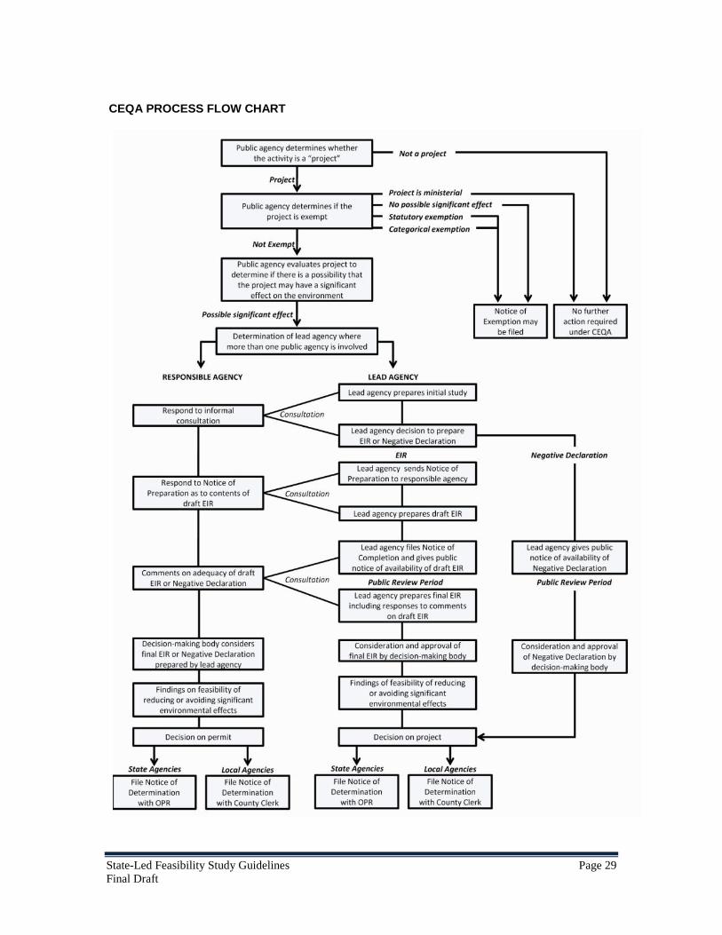
State-Led Feasibility Study Guidelines Page 29 Final Draft
CEQA PROCESS FLOW CHART

State-Led Feasibility Study Guidelines Page 30 Final Draft
6 Communication and Engagement Plan
6.1 Stakeholders Identification, Management, and Outreach
It is important to encourage and support the active participation of all stakeholders in this process through a sincere and well-structured communication and engagement process. Stakeholders are those who are interested in the project and/or may be impacted by the proposed project. They may provide support, criticism, and productive ideas throughout the project planning process. Stakeholders include agencies, interest groups, and individual landowners and non-governmental organizations.
Both CEQA and NEPA require that the lead agency coordinate with, and provide the opportunity for input from, other public agencies and interested stakeholders. For most significant projects undertaken by DWR, both State and federal permits are required, and therefore CEQA and NEPA compliance must be integrated into the planning process from the beginning. It is therefore recommended that the communication and engagement strategy for a DWR feasibility study be structured in compliance with the requirements of both acts. The structured notification, communication, and engagement called for under CEQA and NEPA regulations should be initiated with Step 1 of the planning process to the extent feasible.
The scope and likely impacts of a potential project will largely dictate the extent of the communication, engagement, and environmental documentation effort.
Stakeholders play a major role in the project decision-making process. Their input, even if it is not in support of the project, has value for proper project formulation and the feasibility study. This section will discuss identification of the stakeholders, define their roles and responsibilities, describe an effective communications and outreach plan, and provide guidance for ample opportunities for their input. Following are some considerations in working with stakeholders.
6.2 Communications and Engagement Plan
The Communication and Engagement (C&E) Plan includes an initial list of likely stakeholders and their contact information, a schedule of key activities such as notices, public hearings, distribution of documents for review and comment, and formation of technical committees, and communication and engagement tools and media. It will be used to guide all stakeholder involvement and engagement efforts to ensure an accessible, transparent, collaborative, and inclusive planning process. Some of the key elements of the plan are discussed below.
6.2.1 Identification of Stakeholders
It is important to identify the stakeholders and understand their interest in the project. This can be achieved through early identification of potential impacts of the projects,

State-Led Feasibility Study Guidelines Page 31 Final Draft
those who will be impacted, agencies and their jurisdictions within the project area, and permits (and permitting agencies) that may be needed for project implementation. DWR is in regular contact with local maintaining agencies, permitting agencies, State and federal cooperating agencies, environmental advocacy groups, counties, cities, and communities, and interested individuals. The planning team should take advantage of DWR’s institutional knowledge, supported by experienced outreach consultants when identifying and communicating with likely stakeholders in a new feasibility study process.
It is critical to ensure at the outset of the project that key organizations and stakeholders have a clear understanding of the project and its proposed outcomes. Meeting early with the identified stakeholders is a good idea as the first step in the process. As always follow-up conversations may also occur throughout the project to keep key stakeholders informed.
6.2.2 Establish a Stakeholder Technical Work Group
Establishing a technical work group as a forum for exchanging information with key stakeholders is highly recommended, especially for large and complex projects. The work group would have defined membership and would meet on a scheduled periodic basis to discuss specific tasks and work products. The workgroup would consist of representatives of land owners, reclamation districts, community groups, state and local agency representatives, and agricultural, environmental, and recreational groups.
The stakeholder involvement process should build on “joint fact finding,” where the intent is to provide stakeholders with a clearer understanding of the technical approaches and trade-offs, particularly prior to developing the draft environmental documents. This is often a useful approach in technically complex and controversial settings. Joint fact finding focuses the discussion on determining, as much as possible, an objective basis for making decisions.
6.2.3 Public Meetings
The communication plan should scope a series of public meetings during the course of project implementation. These meetings are in addition to the Stakeholder Technical Work Group meetings discussed earlier. These meetings help DWR to discuss and disseminate the scope and intent of the project, obtain feedback on the proposed preferred project technical issues, and solicit input on the initial results of the analyses.
6.2.4 Meeting with Key Agencies
The DWR planning team should identify the key agencies, including the permitting agencies, and meet with them on a regular basis to brief them on the work in progress. Meeting with the key agencies and receiving their input and support in the planning process is the most critical part of the stakeholder involvement and will greatly facilitate project permitting in the future phase of project implementation.

State-Led Feasibility Study Guidelines Page 32 Final Draft
6.2.5 Other Communication and Engagement Means
6.2.5.1 Dedicated Website
Launching a dedicated website for the development of the project assists stakeholders with maintaining continuous contact with the project management team. This website should be used for announcements and the dissemination of information related to the project, such as public documents, workshop handouts, presentations, etc. A frequently asked questions (FAQ) page should be posted on the website and should be updated periodically to help address general stakeholder questions.
6.2.5.2 Dedicated E-mail and Phone Number
Similar to the website, a dedicated e-mail address helps stakeholders have direct communication with the project team members. Interested stakeholders should be able to subscribe to the mailing list by visiting the website. Announcements related to the project should be sent to subscribers of the mailing list.
6.2.5.3 Informal Meetings and Discussions with Stakeholders
DWR may meet informally with selected stakeholders to gain further understanding of stakeholder input from the workshops or other means of stakeholder input, such as comments received on draft documents. Meetings may also be conducted if gaps or omissions in stakeholder input or perspectives are determined to exist.
6.2.5.4 Web-Based Meetings
As appropriate, DWR may use web-based meeting participation techniques, such as webcasts and webinars, for the dissemination of information related to the project-related documents or other project information.
6.3 Communication and Engagement Schedule
It is important to develop a schedule early in the process for various engagements for the planning process, including the feasibility study process. In general, extensive engagement with agencies is advised early in the study process while workshops and public engagements are more extensive later in the process when technical work is underway and technical information is available to share and discuss with the stakeholders.


State-Led Feasibility Study Guidelines Page 33 Final Draft
7 Project Management Plan
7.1 Project Management Environment
While DWR and its predecessor organizations in the State government have been planning and executing water resources management projects for more than a century, efforts to standardize internal project management practices are fairly recent. DWR’s Project Management Office (PMO) was established to promote best program management practices within DWR and to serve as a resource for project managers. As a result of its efforts, supported by Executives and divisions, DWR follows a structured approach to project management, from inception to completion. Depending upon the scale and complexity of a proposed project, structured thinking about how to successfully execute it may be supported by the following elements:
• Project Charter • Project Management Plan • Communications Plan and Stakeholder Register • Project Schedule • Budget, Work Breakdown Structure, Funding Sources, and DWR Form 1498s • Procurement Plan • Human Resources Plan, Identifying Team Members and their Roles • Risk Register • Quality Management Plan
This document, which provides guidance on one critical aspect of project execution—the feasibility study, is compatible with the project management framework established by PMO. It is intended to facilitate consistency in structure and approach, consistent with best management practices. Like other project management tools, the Project Management Plan (PMP) will evolve over time.
While the listed project management tools and this document provide helpful guidance supporting efficient and effective project execution, the most important ingredients leading to successful project execution are the enthusiasm, determination, judgment, and integrity of the program manager and support staff. Successful execution on almost any scale project involves working with and educating all the individuals and organizations with an interest in a project, and ultimately obtaining concurrence from permitting and funding agencies. A successful project becomes a shared vision during its lifetime. It is important to focus sufficient time and effort on building cooperative relationships, developing mutual respect, and responding constructively to the criticisms, concerns, and recommendations of involved stakeholders.
Typically, the overall scope of a project is described in the Project Charter. The Project Charter summarizes major project objectives, how the project is to be managed, major deliverables, and various other factors.

State-Led Feasibility Study Guidelines Page 34 Final Draft
The PMP describes in detail the purpose, scope activities, strategies, resources, and schedule needed to complete the feasibility study and related studies, such as environmental compliance documentation, technical appendices, and outreach materials. It establishes the common expectations for execution, outcomes, and deliverables for the project. It may include coordination with ongoing and/or future State, federal, and local agencies, which is also a consideration in the communication plan.
The PMP is updated from time to time as the feasibility study evolves.

State-Led Feasibility Study Guidelines Page 35 Final Draft
8 Attachments and Appendices
Attachment A – Benefit Assessment
This attachment outlines performance measures and benefits associated with the fundamental goals: public safety, environmental stewardship, and economic stability.
Performance Measures
A. The performance of a proposed project considering public safety may include the following:
• Number of people in the floodplains will receive additional flood protection? • How many miles of flood corridor will be managed? • Value of assets that will be protected by the proposed project? • Number of the acres of will be enhanced floodplain? • Number of acres of land will be receiving additional flood protection? • Number of structures in the floodplains that will be receiving additional
protection? • Number of miles of levees that will be maintained, repaired, or improved? • Has any of the structures associated with flood management system will be
evaluated and/or rehabilitated • Number of new monitoring stations constructed, maintain or upgrade existing
ones?
B. The performance of a proposed project considering environmental stewardship may include the following:
• The total linear feet of Shaded Riverine Aquatic habitat created by the project • Total coverage in Marsh habitat created or restoration • How many acres of invasive plants are managed by the proposed project • How many acres of Wildlife-friendly Agriculture created • Riverine geomorphic process restoration • How many acres of fish stranding will be reduced in floodways • How many fish barrier has been removed by the project • How many acres of habitat for giant garter snake was created by the project • How many acres of habitat for birds and waterfowls are created by the project

State-Led Feasibility Study Guidelines Page 36 Final Draft
C. The performance of a proposed project considering economic stability may include the following:
• Project increase agricultural productivities and economy • Project results in attracting more businesses in the area • Project increases recreational activities (number of person-day increase in
facilities’ visit) • Number of additional person-day visit of the wildlife areas • Reducing costs ($) associated with the long-term operations and maintenance
Benefits
There are two ways that a management action might benefit California’s water management system. First, an action can provide benefits that bolster the long-term level of service achievable under one or more of DWR’s foundational goals. Examples include reductions in human flood vulnerability that improve public safety, or reductions in expected flood property damages that improve economic stability. The second type of benefit is more indirect – it is the extent to which an action adds resiliency to local and/or statewide provision of those long-term services. The benefits that provide an expected level of long-term service are usually quantifiable, whereas resiliency is something that will likely be qualitatively (though still methodically) considered, and applied numerically only as part of a weighting scheme in a decision-analysis framework. This section focuses on that first type of benefit – those that provide a long-term level of service towards one of DWR’s foundational goals.
A. Benefits that Improve Public Safety Many state agencies and programs are aimed at maintaining and/or improving public safety, and there are a myriad of threats to citizen well-being that are unrelated to water management. For DWR, the goal of improving public safety is defined more precisely by the department’s following three roles within this broader context:
1. Reduction in loss of life, injuries, and/or health risks from flooding 2. Provision of adequate water for domestic needs, sanitation and fire
prevention 3. Reduction in water-borne health threats
Many DWR actions and programs are geared towards directly providing these public safety services. Examples include emergency response teams; flood forecasting, floodplain risk management, levee maintenance, water treatment facilities, water supply infrastructure, and reservoir operations. In addition, some other DWR actions and/or programs can provide public safety services as a secondary product of some otherwise motivated investment. For example, increased groundwater storage for water supply purposes could also serve to increase the system’s ability to absorb flood flows.

State-Led Feasibility Study Guidelines Page 37 Final Draft
An action’s contribution to the long-term provision of public safety is best measured by the amount that it reduces different types of risk, or stabilizes the delivery of needed resources. Ideally, it is feasible to measure an investment’s success at achieving a particular end product of reduced risk or stability, such as reduction in the number of lives lost from flooding. However when budget, time and/or data constraints make accounting of such benefits difficult, then intermediary measurements can serve as a surrogate calculation. For instance, a reduction in the probability of flooding will also likely reduce the number of flooding-related fatalities that occur over time, even though the exact number of reduced fatalities is unknown.
Table 1 lists first the primary end-product benefits that should be used as measures of long-term public safety whenever possible, and then the intermediary benefits that can be substituted if necessary. Keep in mind that these benefits are achievable by many types of management actions, including those not primarily focused on risk management. Also note that if end-product benefits are measureable, then intermediary benefits should not be counted (to avoid double-counting).
Table 1: Benefits that Improve the Expected Long-Term Level of Public Safety
Reducing Flood Risks Adequate Water for Basic Needs
Reducing Water-Borne Health Threats
END-PRODUCT BENEFITS
Reduced Number of Potential Fatalities
Reduced Likelihood of Critical Shortages
Reduced Occurrence of Contaminants in Delivered Drinking Water
Reduced Number of Potential Injuries
Reduced Disruption of Water-dependent Services (not flooding-related)
Reduced Illnesses or other Health Problems
INTERMEDIARY BENEFITS
Reduced Exposure (number of people at risk)
Improved Security for Water Delivery Systems
Reduced Probability of Flooding Improved Source
Water Quality
Reduced Vulnerability Improved Treatment

State-Led Feasibility Study Guidelines Page 38 Final Draft
(ability to evacuate) Efficiencies
Reduced Release of Hazardous Materials
Reduced disruption of critical utility and/or public services
B. Benefits that Foster Environmental Stewardship
Environmental stewardship is defined by DWR as a commitment of responsibility to manage and protect natural resources (water, air, land, plants and animals) and ecosystems in a sustainable manner that ensures they are available for future generations. Improving environmental stewardship in relation to water management results from actions that help to:
• Educate the citizens of California about the interdependencies between water use, flood risk management, and ecosystem function and how citizen’s choices and behaviors impact all three
• Incorporate environmental stewardship principles and methods throughout the entire life cycle (planning, design, permitting, implementation, operation, maintenance, and reauthorization / replacement) of water-related projects and policies
• Reduce wasteful or inefficient use of natural resources • Restore or enhance degraded habitat, and promote healthy watershed functioning
DWR expects that as environmental stewardship expands, the sustainability of natural resources and ecosystems will improve. Describing and measuring long-term levels of environmental stewardship involves two components: 1) improvements in human behavior, and 2) direct environmental improvements. Ideally the first leads to the second, but the uncertain nature of California’s varied ecosystems, climate, etc. make this difficult to guarantee. As such, the second can only be measured by the extent to which environmental improvements are defined and incorporated into state plans and actions, and the likely usefulness of those actions to ecosystem functioning. In terms of human behavior, contributions to environmental stewardship over the long-term can be measured by changes in intent, awareness, and behaviors of people around the interdependencies of water management actions and the sustainability of natural resources and ecosystems.
As mentioned above, uncertainties around climate change, evolving biotic interactions amongst species and the effectiveness of certain restoration measures make it almost impossible to directly measure the primary end product or desired benefit of environmental stewardship: Ecosystem health and natural resources sustainability. As

State-Led Feasibility Study Guidelines Page 39 Final Draft
such, the following table consists almost entirely of those intermediary type benefits that can be used in substitution.
Table 2: Benefits that Improve the Expected Long-Term Level of Environmental Enhancement
Sustainable Use of the State’s
Natural Resources Enhanced Habitats and
Ecosystems
END PRODUCT BENEFITS
Maintained Quantity and Quality of Resources
Healthy Watersheds / Ecosystems
Environmental Principles Incorporated at All Levels of Planning
INTER-MEDIARY BENEFITS
Pollutant Dilution Diversity of Species Benefitted
Soil Formation & Quality Increased Habitat Acreage
Water Quality Restored Natural Geomorphic Processes
Carbon storage and other air quality improvements
Connectivity of Restored Habitat to Broader System
Education and Research Opportunities Complexity of Habitat Types
Species Preservation
Nutrient Cycling
C. Benefits that Support Economic Stability
An economy with fairly constant output growth and low and stable inflation generally is considered economically stable. As with public safety, DWR’s role within the larger state government is to manage water resources in a way that helps promote this broader goal at system-level and regional scales. Water management actions that can help improve economic stability include those that can help:
• Provide reliable water supplies of suitable quality for a variety of beneficial uses (such as business, manufacturing, agriculture, recreation, etc.) that

State-Led Feasibility Study Guidelines Page 40 Final Draft
generate economic income (where reliability is a function of quantity, quality, location, and timing)
• Reduce expected damages and economic disruptions caused by flooding • Produce more benefit from economic activities
o By reducing costs to provide a given level of service (including transaction costs and O&M)
o By providing adequate flood protection to allow for continuing or expanded economic activities within a region
• Reduce the likelihood of significant social disruption
As with the provision of public safety, there are many DWR programs and actions that seek to bolster long-term economic stability. However, as the above list suggests, none of them specifically cite economic stability as a goal. Instead, economic stability is a broader outcome of many smaller goals, such as reliable water supplies for productivity, or reduced economic disruptions from flooding. This makes economic stability the broadest of DWR’s measurable goals in terms of contributing benefits. While this may seem to complicate things, a simplifying factor exists: a unifying unit of measurement. While the measurement of long-term levels of public safety involves various unit types like life lost and water quality, the measurement of economic stability requires just one: dollars. This can take the form of an avoided cost or expected revenues, but either way it is a monetized calculation.
Table 3 lists first the primary end-product benefits that should be used as measures of long-term economic stability whenever possible, and then the intermediary benefits that can be substituted if necessary.
Table 3: Benefits that Improve the Expected Long-Term Level of Economic Stability
Reliable Water
Supplies for Beneficial Uses
Reduced Flood Damages
Added Efficiencies (Reduced
Transaction Costs and Expanded
Activities)
Reduced Social
Disruption
END-PRODUCT BENEFITS
Added Agricultural, Municipal or Industrial Productivity
Avoided Damage to Structures, Contents, & Vehicles
Avoided regulatory compliance / mitigation costs
Avoided Disruption to Normal Societal Functions
Added Recreational Revenues
Avoided Emergency Response Costs
Avoided Water Quality Costs / Treatment

State-Led Feasibility Study Guidelines Page 41 Final Draft
Added Productivity from Ecosystem Services (e.g. fisheries)
Avoided Agricultural Losses
Avoided Energy Costs
Avoided Water Shortage Costs
Avoided Loss of Normal Economic Productivity
Reduced Navigation Costs
Added Hydropower Revenues
Avoided long-term economic stagnation
Reduced O&M Costs
Increased Wealth
Reduced legal costs
INTER-MEDIARY BENEFITS
Additional Water Supply Avoided wage losses Intensification of
Floodplain Use
Additional Power Supplies
Avoided transportation disruptions
Activity added to Floodplain
Salinity Reduction Avoided loss of business net income (including rentals)
Increased Land Value
Water Supply Reliability
Avoided Loss of Public Infrastructure & Services
Avoided Flood Insurance and/or Flood proofing Costs
Avoided evacuation, security, and/or sheltering costs
Increased employment and productivity from project construction
Avoided levee preservation, dewatering, and/or debris cleanup costs
Increases in tax revenues
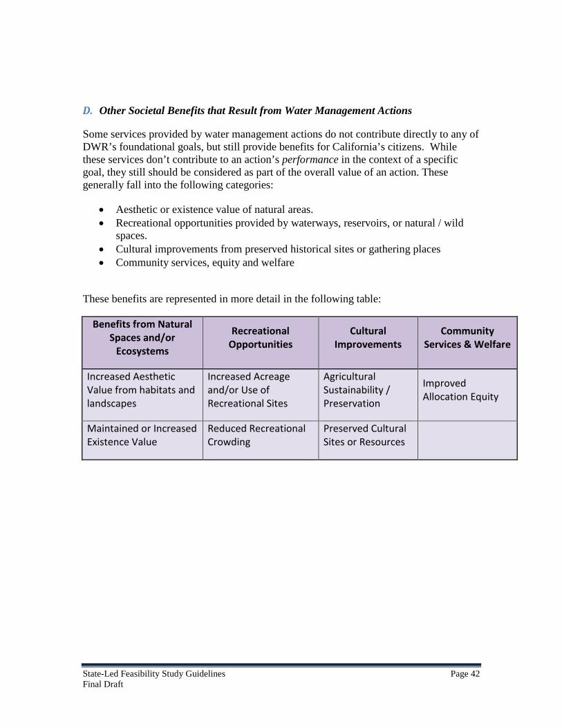
State-Led Feasibility Study Guidelines Page 42 Final Draft
D. Other Societal Benefits that Result from Water Management Actions
Some services provided by water management actions do not contribute directly to any of DWR’s foundational goals, but still provide benefits for California’s citizens. While these services don’t contribute to an action’s performance in the context of a specific goal, they still should be considered as part of the overall value of an action. These generally fall into the following categories:
• Aesthetic or existence value of natural areas. • Recreational opportunities provided by waterways, reservoirs, or natural / wild
spaces. • Cultural improvements from preserved historical sites or gathering places • Community services, equity and welfare
These benefits are represented in more detail in the following table:
Benefits from Natural Spaces and/or
Ecosystems
Recreational Opportunities
Cultural Improvements
Community Services & Welfare
Increased Aesthetic Value from habitats and landscapes
Increased Acreage and/or Use of Recreational Sites
Agricultural Sustainability / Preservation
Improved Allocation Equity
Maintained or Increased Existence Value
Reduced Recreational Crowding
Preserved Cultural Sites or Resources

State-Led Feasibility Study Guidelines Page 43 Final Draft
Attachment B
SAMPLE ENVIRONMENTAL CHECKLIST FORM
Environmental Issues Potentially Significant
Impact
Less Than Significant
With Mitigation
Incorporated
Less Than Significant
Impact No Impact
I. AESTHETICS. Would the project:
a) Have a substantial adverse effect on a scenic vista?
b) Substantially damage scenic resources, including, but not limited to, trees, rock outcroppings, and historic buildings within a state scenic highway?
c) Substantially degrade the existing visual character or quality of the site and its surroundings?
d) Create a new source of substantial light or glare which would adversely affect day or nighttime views in the area?
Environmental Issues Potentially Significant
Impact
Less Than Significant
With Mitigation
Incorporated
Less Than Significant
Impact No Impact
II. AGRICULTURAL RESOURCES
In determining whether impacts to agricultural resources are significant environmental effects, lead agencies may refer to the California Agricultural Land Evaluation and Site Assessment Model (1997), prepared by the California Department of Conservation as an optional model for use in assessing impacts on agricultural and farmland.
Would the project
a) Convert Prime Farmland, Unique Farmland, or Farmland of Statewide Importance (Farmland), as shown on the maps prepared pursuant to the Farmland Mapping and Monitoring Program of the California Resources Agency, to non-

State-Led Feasibility Study Guidelines Page 44 Final Draft
agricultural use?
b) Conflict with existing zoning for agricultural use or a Williamson Act contract?
c) Involve other changes in the existing environment, which, due to their location or nature, could result in conversion of Farmland to non-agricultural use?
Environmental Issues Potentially Significant
Impact
Less Than Significant
With Mitigation
Incorporated
Less Than Significant
Impact No Impact
III. AIR QUALITY
Where available, the significance criteria established by the applicable air quality management or air pollution control district may be relied on to make the following determinations.
Would the project:
a) Conflict with or obstruct implementation of the applicable air quality plan or regulation?
b) Violate any air quality standard or contribute substantially to an existing or projected air quality violation?
c) Result in a cumulatively considerable net increase of any criteria pollutant for which the project region is in non-attainment under an applicable federal or state ambient air quality standard (including releasing emissions which exceed quantitative thresholds for ozone precursors)?
d) Expose sensitive receptors to substantial pollutant concentrations (e.g., children, the elderly, and individuals with compromised respiratory or immune systems)?
e) Create objectionable odors affecting a substantial number of people?

State-Led Feasibility Study Guidelines Page 45 Final Draft
Environmental Issues Potentially Significant
Impact
Less Than Significant
With Mitigation
Incorporated
Less Than Significant
Impact No Impact
IV. BIOLOGICAL RESOURCES. Would the project
a) Have a substantial adverse effect, either directly or through habitat modification, on any species identified as a sensitive, candidate, or special-status species in local or regional plans, policies, or regulations, or by the California Department of Fish and Game or the U.S. Fish and Wildlife Service?
b) Have a substantial adverse effect on any riparian habitat or other sensitive natural community identified in local or regional plans, policies, or regulations, or by the California Department of Fish and Game or the U.S. Fish and Wildlife Service?
c) Have a substantial adverse effect on federally protected wetlands, as defined by §404 of the Clean Water Act (including, but not limited to, marsh, vernal pool, coastal, etc.) through direct removal, filling, hydrological interruption, or other means?
d) Interfere substantially with the movement of any native resident or migratory fish or wildlife species or with established native resident or migratory wildlife corridors, or impede the use of native wildlife nursery sites?
e) Conflict with any local policies or ordinances protecting biological resources, such as a tree preservation policy or ordinance?
f) Conflict with the provisions of an adopted Habitat Conservation Plan, Natural Community Conservation Plan, or other approved local, regional, or state habitat conservation plan?
Environmental Issues Potentially Significant
Impact
Less Than Significant
With Mitigation
Incorporated
Less Than Significant
Impact No Impact
V. CULTURAL RESOURCES. Would the project:

State-Led Feasibility Study Guidelines Page 46 Final Draft
a) Cause a substantial adverse change in the significance of a historical resource, as defined in §15064.5?
b) Cause a substantial adverse change in the significance of an archaeological resource, pursuant to§15064.5?
c) Directly or indirectly destroy a unique paleontological resource or site, or unique geologic feature?
d) Disturb any human remains, including those interred outside of formal cemeteries?
Environmental Issues Potentially Significant
Impact
Less Than Significant
With Mitigation
Incorporated
Less Than Significant
Impact No Impact
VI. GEOLOGY AND SOILS. Would the project:
a) Expose people or structures to potential substantial adverse effects, including the risk of loss, injury, or death involving:
i) Rupture of a known earthquake fault, as delineated on the most recent Alquist-Priolo Earthquake Fault Zoning Map, issued by the State Geologist for the area, or based on other substantial evidence of a known fault? (Refer to Division of Mines and Geology Special Publication 42.)
ii) Strong seismic ground shaking?
iii) Seismic-related ground failure, including liquefaction?
iv) Landslides?
b) Result in substantial soil erosion or the loss of topsoil?
c) Be located on a geologic unit or soil that is unstable, or that would become unstable, as a result of the project and potentially result in on- or off-site landslide, lateral spreading, subsidence, liquefaction, or collapse?
d) Be located on expansive soil, as defined in Table 18-1-B of the Uniform Building Code (1997), creating substantial risks to life or

State-Led Feasibility Study Guidelines Page 47 Final Draft
property?
e) Have soils incapable of adequately supporting the use of septic tanks or alternative waste disposal systems, where sewers are not available for the disposal of waste water?
Environmental Issues Potentially Significant
Impact
Less Than Significant
With Mitigation
Incorporated
Less Than Significant
Impact No Impact
VII. HAZARDS AND HAZARDOUS MATERIALS. Would the project:
a) Create a significant hazard to the public or the environment through the routine transport, use, or disposal of hazardous materials?
b) Create a significant hazard to the public or the environment through reasonably foreseeable upset and/or accident conditions involving the release of hazardous materials, substances, or waste into the environment?
c) Emit hazardous emissions or handle hazardous or acutely hazardous materials, substances, or waste within one-quarter mile of an existing or proposed school?
d) Be located on a site which is included on a list of hazardous materials sites, compiled pursuant to Government Code §65962.5, and, as a result, create a significant hazard to the public or environment?
e) Be located within an airport land use plan or, where such a plan has not been adopted, within two miles of a public airport or public use airport? If so, would the project result in a safety hazard for people residing or working in the project area?
f) Be located in the vicinity of a private airstrip? If so, would the project result in a safety hazard for people residing or working in the project area?
g) Impair implementation of or physically interfere with an adopted emergency response plan or emergency evacuation plan?

State-Led Feasibility Study Guidelines Page 48 Final Draft
h) Expose people or structures to a significant risk of loss, injury, or death from wildland fires, including areas where wildlands are adjacent to urbanized areas or where residences are intermixed with wildlands?
Environmental Issues Potentially Significant
Impact
Less Than Significant
With Mitigation
Incorporated
Less Than Significant
Impact No Impact
VIII. HYDROLOGY AND WATER QUALITY.
Would the project:
a) Violate any water quality standards or waste discharge requirements?
b) Substantially deplete groundwater supplies or interfere substantially with groundwater recharge, such that there would be a net deficit in aquifer volume or a lowering of the local groundwater table level (e.g., the production rate of pre-existing nearby wells would drop to a level that would not support existing land uses or planned uses for which permits have been granted)?
c) Substantially alter the existing drainage pattern of the site or area, including through alteration of the course of a stream or river, in a manner which would result in substantial on- or off-site erosion or siltation?
d) Substantially alter the existing drainage pattern of the site or area, including through alteration of the course of a stream or river, or substantially increase the rate or amount of surface runoff in a manner which would result in on- or off-site flooding?
e) Create or contribute runoff water which would exceed the capacity of existing or planned stormwater drainage systems or provide substantial additional sources of polluted runoff?
f) Substantially degrade water quality?
g) Place housing within a 100-year flood hazard area, as mapped on a federal Flood Hazard Boundary or Flood Insurance Rate Map, or other flood hazard delineation map?

State-Led Feasibility Study Guidelines Page 49 Final Draft
h) Place structures that would impede or redirect flood flows within a 100-year flood hazard area?
i) Expose people or structures to a significant risk of loss, injury, or death from flooding, including flooding resulting from the failure of a levee or dam?
j) Result in inundation by seiche, tsunami, or mudflow?
Environmental Issues Potentially Significant
Impact
Less Than Significant
With Mitigation
Incorporated
Less Than Significant
Impact No Impact
IX. LAND USE AND PLANNING. Would the project:
a) Physically divide an established community?
b) Conflict with the applicable land use plan, policy, or regulation of any agency with jurisdiction over the project (including, but not limited to, a general plan, specific plan, local coastal program, or zoning ordinance) adopted for the purpose of avoiding or mitigating an environmental effect?
c) Conflict with any applicable habitat conservation plan or natural community conservation plan?
Environmental Issues Potentially Significant
Impact
Less Than Significant
With Mitigation
Incorporated
Less Than Significant
Impact No Impact
X. MINERAL RESOURCES. Would the project:
a) Result in the loss of availability of a known mineral resource that is or would be of value to the region and the residents of the state?
b) Result in the loss of availability of a locally important mineral resource recovery site delineated on a local general plan, specific plan, or other land use plan?

State-Led Feasibility Study Guidelines Page 50 Final Draft
Environmental Issues Potentially Significant
Impact
Less Than Significant
With Mitigation
Incorporated
Less Than Significant
Impact No Impact
XI. NOISE. Would the project:
a) Generate or expose people to noise levels in excess of standards established in a local general plan or noise ordinance, or in other applicable local, state, or federal standards?
b) Generate or expose people to excessive groundborne vibrations or groundborne noise levels?
c) Create a substantial permanent increase in ambient noise levels in the vicinity of the project (above levels without the project)?
d) Create a substantial temporary or periodic increase in ambient noise levels in the vicinity of the project, in excess of noise levels existing without the project?
e) Be located within an airport land use plan or, where such a plan has not been adopted, within two miles of a public airport or public use airport? If so, would the project expose people residing or working in the project area to excessive noise levels?
f) Be in the vicinity of a private airstrip? If so, would the project expose people residing or working in the project area to excessive noise levels?
Environmental Issues Potentially Significant
Impact
Less Than Significant
With Mitigation
Incorporated
Less Than Significant
Impact No Impact
XII. POPULATION AND HOUSING. Would the project:
a) Induce substantial population growth in an area, either directly (for example, by proposing new homes and businesses) or indirectly (for example, through extension of roads or other infrastructure)?

State-Led Feasibility Study Guidelines Page 51 Final Draft
b) Displace substantial numbers of existing housing, necessitating the construction of replacement housing elsewhere?
c) Displace substantial numbers of people, necessitating the construction of replacement housing elsewhere?
Environmental Issues Potentially Significant
Impact
Less Than Significant
With Mitigation
Incorporated
Less Than Significant
Impact No Impact
XII. PUBLIC SERVICES. Would the project:
a) Result in significant environmental impacts from construction associated with the provision of new or physically altered governmental facilities, or the need for new or physically altered governmental facilities, to maintain acceptable service ratios, response times, or other performance objectives for any of the public services:
Fire protection?
Police protection?
Schools?
Parks
Other public facilities?
Environmental Issues Potentially Significant
Impact
Less Than Significant
With Mitigation
Incorporated
Less Than Significant
Impact No Impact
XIV. RECREATION. Would the project:
a) Increase the use of existing neighborhood and regional parks or other recreational facilities, such that substantial physical deterioration of the facility would occur or be accelerated?
b) Include recreational facilities or require the construction or expansion of recreational facilities that might have an adverse physical effect on the environment?

State-Led Feasibility Study Guidelines Page 52 Final Draft
Environmental Issues Potentially Significant
Impact
Less Than Significant
With Mitigation
Incorporated
Less Than Significant
Impact No Impact
XV. TRANSPORTATION/TRAFFIC. Would the project:
a) Cause a substantial increase in traffic, in relation to existing traffic and the capacity of the street system (i.e., a substantial increase in either the number of vehicle trips, the volume to capacity ratio on roads, or congestion at intersections)?
b) Exceed, individually or cumulatively, the level of service standards established by the county congestion management agency for designated roads or highways?
c) Cause a change in air traffic patterns, including either an increase in traffic levels or a change in location, which results in substantial safety risks?
d) Contain a design feature (e.g., sharp curves or a dangerous intersection) or incompatible uses (e.g., farm equipment) that would substantially increase hazards?
e) Result in inadequate emergency access?
f) Result in inadequate parking capacity?
g) Conflict with adopted policies, plans, or programs supporting alternative transportation (e.g., bus turnouts, bicycle racks)?
Environmental Issues Potentially Significant
Impact
Less Than Significant
With Mitigation
Incorporated
Less Than Significant
Impact No Impact
XVI. UTILITIES AND SERVICE SYSTEMS.
Would the project
a) Exceed wastewater treatment restrictions or standards of the applicable Regional Water Quality Control Board?
b) Require or result in the construction of new water or wastewater treatment facilities or expansion of existing facilities, the construction of which could cause significant environmental

State-Led Feasibility Study Guidelines Page 53 Final Draft
effects?
c) Require or result in the construction of new storm water drainage facilities or expansion of existing facilities, the construction of which could cause significant environmental effects?
d) Have sufficient water supplies available to serve the project from existing entitlements and resources or are new or expanded entitlements needed?
e) Result in a determination, by the wastewater treatment provider that serves or may serve the project, that it has adequate capacity to service the project’s anticipated demand, in addition to the provider’s existing commitments?
f) Be served by a landfill with sufficient permitted capacity to accommodate the project’s solid waste disposal needs?
g) Comply with federal, state, and local statutes and regulations as they relate to solid waste?
Environmental Issues Potentially Significant
Impact
Less Than Significant
With Mitigation
Incorporated
Less Than Significant
Impact No Impact
XVII. MANDATORY FINDINGS OF SIGNIFICANCE.
a) Does the project have the potential to degrade the quality of the environment, substantially reduce the habitat of any fish or wildlife species, cause any fish or wildlife to drop below self-sustaining levels, threaten or eliminate a plant or animal community, reduce the number or restrict the range of any rare, protected, special, or endangered plant or animal, or eliminate important examples of the major periods of California history or prehistory?
b) Does the project have impacts that are individually limited, but cumulatively considerable? (“Cumulatively considerable” means the incremental effects of a project are considerable when viewed in connection with the effects of past projects, the effects of other current projects, and the effects of probable future projects).

State-Led Feasibility Study Guidelines Page 54 Final Draft
c) Does the project have environmental effects which will cause substantial adverse effects on human beings, either directly or indirectly?

State-Led Feasibility Study Guidelines Page 55 Final Draft
Appendices
A feasibility study is accompanied with a series of technical studies and investigations to support the preferred alternative. The appendices need to provide support and justification for the selected preferred project alternative to resolve the issues and meet the objectives identified in the feasibility report. Not every appendix is required for every project. DWR staff has the discretion to decide which appendix is needed to support the preferred alternative. The Appendices are presented in a separate document.


Guidelines for Preparation of Appendices in Support of a State-Led Feasibility Study
Department of Water Resources
December 2014


State-Led Feasibility Study Guidelines Appendices Page 1 Final Draft
Hydrology Modeling
Introduction The topography and climate of California are extremely diverse, ranging from low elevations at the coast and Central Valley Delta, to the high altitudes of the Sierras; from less than 3 inches of annual rainfall in the southeast desert basins to over 120 inches on the extreme north coast. Drainage basins vary in size from portions of an acre to thousands of square miles. Stream gages are sparse in most areas and are essentially nonexistent in the undeveloped areas. Accurate estimation of rare flood flows from recorded data is especially difficult due to the lack of basic site-specific flow data from which the flood producing potential of a drainage basin can be predicted. However, hydrologic estimates of rare floods must be developed for all types of hydraulic structures to be used in evaluation of dam spillway culvert and structure capacities.
The most fundamental part of any flood hydrology analysis is the compilation and analysis of hydrologic and meteorological data accumulated during and after severe flood events. These data are required in the development of criteria by hydro-meteorologists for making flood frequency estimates and development of unit hydrograph and infiltration parameters necessary to determine the rainfall-runoff relationships for both gauged and ungauged basins, and for preparing discharge-probability relationships. Hydrologic data include records of flood runoff measured at continuous recording stream flow gauges, crest stage stream flow gauges, indirect peak discharge measurements based on flood marks at locations where there are no stream gauges, and reservoir operation records from which inflow hydrographs may be determined based on outflow and change of storage relationships.
Methods and Procedures This section presents the basic methods and procedures that should be included to perform hydrology modeling.
Problem Definition and Selection of Methodology: This should be evaluated to identify and describe the goal and needed products of flood-runoff analysis, which includes the types of investigation for which these products are required. Aspects of flood hydrology should be discussed, including physical processes, data availability, and broad approaches to analysis.
Study Area: Defining the study area provides context and boundaries for collecting the data and information on the study watershed needed to determine natural inflow and hydrologic conditions of the basin tributary to the proposed facility. The types of data and information collected includes gauge data such as rainfall, temperature, snow, infiltration (loss), surface and subsurface runoff, and historic flow in channels and reservoirs.

State-Led Feasibility Study Guidelines Appendices Page 2 Final Draft
Hydrologic Analysis: Includes application of techniques such as frequency analysis of stream flow data, precipitation-runoff simulation of storm events, and period-of-record precipitation-runoff simulation. Data requirements, assumptions made, and calibration/verification of simulation models are considered and discussed.
Conclusions and Engineering Applications. The lack of historical stream-flow data is the source of much difficulty and uncertainty in flood runoff analysis. Methods of handling “ungaged” basins and other limitations should be evaluated and discussed. Issues associated with the development of frequency-based estimates, including the concept of calibration to “known” frequency information. Various aspects of modeling land use change, as well as the effects of reservoirs and other projects, are discussed for conclusion and design considerations.
Typical Hydrology Study Outline 1.0 INTRODUCTION 1.1 Purpose of Study 1.2 Coordination 2.0 AREA STUDIED 2.1 Scope of Study 2.2 Community Description 2.3 General Basin Description and Reservoir Regulation 2.4 Topography and Geology 2.5 Vegetation 2.6 Climate 2.7 Stream Flow 2.8 Existing Infrastructure 2.9 Principal Flood Problems and Flood History 2.10 Flood Protection Measures 3.0 HYDROLOGIC ANALYSIS 3.1 Study Subareas 3.2 Unit Hydrograph 3.3 Loss Data 3.4 Project Storm 3.5 Project Flood 3.6 Study Results 3.7 Calibration of Model 3.8 Modeling Hypothetical Events 3.9 Analysis of River Tributaries 3.10 Land Use Practices and Its Effect on Runoff
4.0 CONCLUSIONS
State-Led Feasibility Study Guidelines Appendices Page 3 Final Draft
Reservoir Operations/Reoperations
Introduction Reservoir operations studies should include a preliminary assessment of goals and objectives prior to evaluation of strategies for improved or reoperation studies. The preliminary assessment study should evaluate, sort, and rank the reoperation strategies based on their performance in meeting the goals and objectives of the study. Strategies for studies associated with flood control projects can then be examined for acceptability, completeness, and effectiveness.
The Procedure A study should include the following discussions:
• Defining baseline operations: Each reservoir must operate in accordance with the USACE flood control guidelines specific to its watershed; however, there is some uniqueness in every situation.
• Defining the operations of the strategies • Evaluating system reoperation strategies • Identifying existing physical and operational constraints • Identifying new or modified physical facilities for potential system improvements
strategies • Conducting hydrologic and other modeling • Quantifying benefits • Analyzing appropriate climate change scenarios • Ranking reoperation strategies based on their performance • Selecting reoperation strategies to be carried forward into Phase 4 for more
detailed analysis • The strategies evaluated should meet the objectives of the study and can be
carried forward for more detail evaluations that can include o Analyzing and assessing reoperation strategies o Evaluating ability of strategies to reduce or minimize impacts of climate
change on water supply, flood management, and ecosystems o Evaluating benefits o Evaluating costs o Quantifying economic benefits o Developing conceptual designs for facilities modifications o Identifying institutional challenges o Documenting the findings o Recommending strategies for potential implementation o Identifying funding and key steps necessary for implementation o Making recommendations for next steps o Preparing the final SRS report


State-Led Feasibility Study Guidelines Appendices Page 4 Final Draft
Hydraulics Modeling
Introduction Hydraulic modeling documents are available to assist engineers and planners in developing guidelines for detailed evaluation and/or feasibility study alternatives. These guidelines and procedures are critical in providing consistency for each of the alternatives or if multiple teams are involved in working on various parts of the system. Hydraulic model theories can be found in various documents and publications, but the design procedures may not be fully covered in these documents or different parts of the system may require a different set of conditions. Documents provided by the Federal Emergency Management Agency (FEMA), the United States Army Corps of Engineers (USACE) and/or the Federal Highway Administration (FHWA) can provide additional detail to aid in developing the Hydraulic Design Criteria needed to assist in the preliminary design. After the preliminary design layout, the use of detailed models using best available information can verify if the alternatives are feasible.
Methods and Procedures The following hydraulic model guidelines should provide a clear understanding of the content of a hydraulics modeling appendix:
• What are the study reaches under review? • Does the study reach limits cover the entire impact area to evaluate upstream and
downstream conditions? The reach limits should include the impact area. There may be instances that the boundaries are not extended to cover the impact area. It is imperative that the appendix clearly discusses the obstacles and provides a recommendation to resolve this issue, if exists.
• Are there potential upstream and downstream impacts to existing parcels if channel improvements are made to increase channel capacities?
• What is the acceptable hydrology to be used for design conditions? • Will multiple storm frequencies be required to review multiple flow conditions? • What is the best available information (models, topographic, standards) to be used
to evaluate the various alternatives or will new models be required to be developed? Is there an approved FEMA FIS model completed for the stream?
• Coordinate consistent methods and procedures between federal, State, and local agencies.
• Determine the hydraulic model tolerances that will be used for the model conditions.
• Determine levee locations and if the levee has been certified or not certified. • Will setback levees potentially improve conditions? • Identify FEMA floodway limits. • Identify downstream boundary conditions.

State-Led Feasibility Study Guidelines Appendices Page 5 Final Draft
• Will the existing or future channel require maintenance or will the channel design be unmaintained with heavy vegetation?
• Are there gages or high-water mark data to calibrate the model reaches? • Identify all critical facilities within the riverine and overbank floodplains. • Are there structures that need to be potentially adjusted because of flow
constrictions?

State-Led Feasibility Study Guidelines Appendices Page 6 Final Draft
Climate Change
Introduction The Climate Change appendix may be one of the more difficult appendices to write since it is relatively a new area and there are few sources that agree on the same guidance. Therefore guidance documents are prepared mostly relying on the “Climate Change Handbook for Regional Water Planning” published in 2012 by the US Environmental Protection Agency, California Department of Water Resources and U.S. Army Corps of Engineers. This section discusses reasonable approach on formulation of an appendix in support of the feasibility study selected alternative.
Methodology and Procedures 1. Literature Review Review of existing climate change literature and knowledge base including:
• Local Climate Action Plans and Case Studies • Regional Climate Studies and Plans including Climate Studies in IRWMPs • Climate provisions of State Reports, Studies and Plans such as the California
Water Plan • Federal Climate Reports and Studies including Sea Level Rise studies by the
National Research Council 2. Review of Regulatory Requirements Review of existing regulations including:
• Local Permitting Requirements • Regional Climate Studies and Plans including Climate Studies in IRWMPs • Climate Reports and Studies by State Agencies • Federal Climate Reports and Studies
3. Analysis of Climate Change Have you considered the following to perform climate change analysis for your project?
• Analysis of historical climate change and trends • Analysis of historical climate variability • Analysis of future climate change projections • Analysis of sea level rise projections • Climate Change models

State-Led Feasibility Study Guidelines Appendices Page 7 Final Draft
4. Flood Events Have you assessed changes in risk of flooding, flood events and flood flows due to climate change within your project area?
• Analysis of impacts of increased variability and seasonality of flood flows • Analysis of changes in frequency, timing, and duration of flood events • Analysis of effectiveness of water supply and demand associated with integrated
flood management in your project area • Analysis of flood flow requirements to support aquatic life and frequency of
failure to meet those requirements • Assessing vulnerability of critical infrastructure to changing frequency and
severity of extreme storms on your project area • Assessing public safety impacts of increased flooding including evacuation
routes, emergency personnel access, hospitals, water treatment and wastewater treatment plants, power generation plants and fire stations
• Assessing regional or economic impacts of increased flooding • Assessing vulnerability of flood protection infrastructure including levees,
impoundment structures, floodgates and other flood control facilities • Assessing potential for mudslides, debris floods and other earth movements due to
increased flooding, altered landscapes and soil conditions 5. Ecosystem and Habitat Vulnerability Have you assessed changes in ecosystems and habitats due to climate change in your project area including:
• Assessing the vulnerability of inland or coastal aquatic habitats to erosion and sedimentation
• Analysis of changes in estuarine habitats due to changes in seasonality and duration of high and low freshwater flows
• Evaluating climate-sensitive fauna or flora populations in your project area • Evaluating impacts of climate change on the presence or distribution of
endangered or threatened species in your project area • Assessing the vulnerability of aquatic or water-dependent habitats used for
recreation or other economic activities • Evaluating potential difficulties meeting quantified environmental flow
requirements or constrained water quality and quantity requirements • Assessing the vulnerability of estuaries, coastal dunes, wetlands, marshes, or
exposed beaches to changes in coastal storm characteristics • Assessing the vulnerability of habitats supporting endangered species • Assessing the vulnerability of fragmented estuarine, aquatic, or wetland wildlife
habitats and movement corridors for migrating species

State-Led Feasibility Study Guidelines Appendices Page 8 Final Draft
Geomorphology
Introduction Geomorphology evaluates the origin, evolution, distribution, and form of landforms. Geomorphology can help to develop information on surface and shallow subsurface conditions according to delineated geologic features. In addition, geomorphology provides information that can be used to guide the application of limited resources at the feasibility level. This is particularly useful for projects that cover large areas, as it helps to identify regionally consistent zones within a larger area that will in-turn aid in identifying possible areas of concern. For example, geomorphology that indicates levees or dams overlying buried channels or young, near surface deposits may suggest susceptibility to underseepage.
Methodology Typically, geomorphic features are delineated in practice through:
• Early United States Geological Survey (USGS) topographic maps • Modern United States Geological Survey (USGS) topographic maps • Early United States Department of Agriculture (USDA) soil maps • Early geologic maps • Modern geologic maps • Combination of aerial photographs and topography • Scientific reports • Engineering reports
According to the U. S. Army Corps of Engineers (USACE) EM 1110-1-1804, a feasibility study should contain summaries of the regional geology, soils, and seismological conditions for each detailed project alternative. These summaries are used to discuss the general geotechnical merits and drawbacks of each project alternative. Geomorphology is used in these summaries to help describe the history, thickness, engineering character, and rock type at a project site. Typically, a feasibility study should include a regional geology map and regional geological sections showing the spatial relationship of rock units and major geologic structures.
It should be noted there are limitations to the application of geomorphology as a screening tool when evaluating surface or shallow subsurface stratigraphy, which are:
• Map scaling can be very large. This limits the accuracy in determining the boundaries between geomorphic features.
• Maps are normally general, and do not typically capture unique site-specific geomorphic regions.

State-Led Feasibility Study Guidelines Appendices Page 9 Final Draft
• Boundaries shown between geologic features are not abrupt, and may occur gradually.
• Geomorphology does not capture recent construction, such as placed earthen embankments, if mapping has not been completed recently.

State-Led Feasibility Study Guidelines Appendices Page 10 Final Draft
Groundwater Management
Introduction If a proposed project contains a groundwater effecting component, groundwater feasibility should be investigated for the component(s) that interact with groundwater.
Groundwater feasibility components are concerned with understanding physical groundwater conditions in the project area, political and regulatory conditions in the project area, effects the proposed project may have on those conditions, and potential monitoring of those effects.
Methodology A groundwater feasibility study should consider the following components:
Physical Conditions:
• What is the local groundwater flow direction and gradient? • Is groundwater used locally as drinking water supply? Agricultural supply? • Is hydrogeology in the project area amenable to the groundwater activity? • Are there groundwater quality problems present near the site area? Review of the
Regional Water Quality Control Board’s (RWQCB) GeoTracker website will help with this question.
• What are the long-term water level trends? Department of Water Resources’ (DWR) Water Data Library and CASGEM sites will help with this question.
• Is there land subsidence occurring in the area? • Are there adequate supplies available for the project? • Are supplies of the correct quality for the intended use?
Political and Regulatory Conditions:
• Is the groundwater basin adjudicated? • What entity is managing groundwater in the area? (County, JPA, City, Water
District) • What permits apply to discharges to land or surface water in the project area? • If the project includes a well, what well permits are required?
Effects of the Proposed Project:
• Will the project improve or lower groundwater conditions? • Will the project improve or deteriorate groundwater quality? • Will the project cause increased interaction of groundwater and surface water? • If the project generates water for use, is the water generated cost effective
compared to other options such as piping in existing supplies or surface water?
State-Led Feasibility Study Guidelines Appendices Page 11 Final Draft
Monitoring of Effects:
• What groundwater level monitoring will be necessary to define changes on the affected aquifer?
• What groundwater quality monitoring will be necessary to define changes to groundwater quality?
• What monitoring is needed to identify potential groundwater – surface water interaction?

State-Led Feasibility Study Guidelines Appendices Page 12 Final Draft
Water Supply
Introduction Water supply feasibility documentation should be developed for mathematical modeling and methodology, potential water sources, water rights, physical facilities, and overall water budgeting for the project study. Climate Change is an important part of this discussion and may be consolidated in this appendix.
Methodology The water supply portion may address the following:
• What is the local water flow direction and gradient? • Is water used locally as drinking water or agricultural supply? • Is hydrogeology in the project area amenable to the project needs? • What are the long-term water supply trends in the project study area? • Are there adequate supplies available for the project? • Who has the water rights in the project study area? • What entity is managing the water in the area? (County, JPA, City, Water
District) • What permits apply to tap into the existing water in the project area? • If the project generates water for use, is the water generated cost effective
compared to other options. • Will the project cause any impacts on the water supply in the project area?


State-Led Feasibility Study Guidelines Appendices Page 13 Final Draft
Water Quality
Introduction The water quality portion needs to address the pollutants; both existing and those generated by the project selected in the feasibility study, and discuss various treatment methods and potential increases in costs. There are many ways that water investments can reduce the need for water treatment and cleanup, these may include source pollution controls, more efficient treatment technologies, recycling programs, and shifts in end use for various water supplies and their application to both urban and agricultural sectors.
Methodology The water quality portion may address the following:
• Are there water quality problems present near the site area? • Are supplies of the correct quality for the intended use? • What are the water quality standards? • What entity is managing the water quality in the area? • What permits apply to discharges to land or surface water in the project area? • Will the project have any impacts on the water quality in the project area? • What water level monitoring will be necessary to define changes on the affected
aquifer? • What is the water quality monitoring for the project? • What constituencies should be monitored in order to maintain the level of quality? • What are the frequencies of monitoring? • What are the thresholds for each constituency?


State-Led Feasibility Study Guidelines Appendices Page 14 Final Draft
Ecosystem Restoration
Introduction The purpose of this appendix is to generally describe the restoration related tasks to be accomplished during the project implementation phase. The restoration feasibility study is to be part of, and linked to, the overall project feasibility process, and will also be used as part of environmental review pursuant to CEQA and NEPA. Restoration elements of a project defined during the feasibility study include development and screening of the restoration elements to be included in the primary project alternative. DWR has embraced integrated flood management (IFM) and seeks to meet multiple objectives through inclusion of restoration features in project designs.
Restoration is different from mitigation. The purpose of mitigation is to reduce impacts. Restoration seeks to provide benefits in addition to, or beyond those, required to mitigate for project impacts, and to reverse the adverse impacts of human activity and restore ecological resources, including fish and wildlife habitats, to previous levels of productivity but not a higher level than would have existed under natural conditions in the absence of human activity or disturbance. The key to project formulation and evaluation is developing a complete understanding of current ecological conditions within the study area and how those conditions will change with and without the proposed alternatives over the project life.
Methodology At minimum, the ecosystem restoration appendix to a feasibility study should address the following, when applicable to the project study area:
• The project study area needs to be surveyed and assessed to provide a clear understanding of existing habitat.
• The feasibility study needs to demonstrate that the proposed ecosystem restoration actions support a diversity of native plant communities and significant fish and wildlife resources.
• If the proposed actions increase the current and potential value for biological resources in the project area.
• A discussion on restoring the natural dynamic processes that support aquatic and terrestrial species in the project area as well as the unintended effects of altering natural processes by implementation of the project.
• Bank protection and revetment on eroding banks, if any, and availability of shaded riverine aquatic (SRA) habitat for terrestrial and aquatic species.
• Discuss changes in native habitat that rely on natural vegetation on the banks for nesting.
• Change in populations of species in the study area.

State-Led Feasibility Study Guidelines Appendices Page 15 Final Draft
• Discuss species adversely affected by the project as a result of changes in hydrologic, hydraulics, and geomorphology.
• Discussion on riparian, upland habitats, and Shaded Riverine Aquatic habitat, if present.
• Discussion of aquatic habitats for salmonids and other native fishes, including special-status fish species.
• Discussion on connectivity of wildlife habitats. • Management actions to restore and/or enhance existing habitat.

State-Led Feasibility Study Guidelines Appendices Page 16 Final Draft
Energy
Introduction Determining the energy requirements of a project is fundamental to several assessments (i.e., impacts assessments for CEQA compliance) and plans (i.e., financial plans). It is also a basic requirement for determining potential climate impacts and greenhouse gas emissions from the project. An energy evaluation should consider all related energy requirements for both construction and operation and identify energy-saving options with an eye to cost savings without compromising the success of the project. Conducting the energy evaluation at the feasibility study stage allows recommendations to be incorporated into the design and operation of the project.
Methodology An energy evaluation should include:
• An inventory of all energy consuming equipment and facilities (vehicles, motors, buildings, or trailers, etc.)
• Estimates of potential energy usage by the equipment and facilities, including electricity, natural gas, other fuels
• Descriptions and evaluation of potential energy-saving ideas (including use of on-site renewable energy resources) and the technical feasibility of implementation
• Description of methods used in the evaluation, as well as all calculations and assumptions
• Designated Energy Resource Manager (if applicable) • Estimated cost and savings for measures to be implemented in the design of the
project, as well as estimated payback periods and financing mechanism • Timelines for the implementation of identified energy efficiency investments or
energy conservation measures • Follow-up strategies and reports on implemented measures • Project benchmarking information • A description of potential reductions of greenhouse gases and mitigation of
potential climate impacts of selected energy-savings measures


State-Led Feasibility Study Guidelines Appendices Page 17 Final Draft
Operations and Maintenance
Introduction The USACE has delegated the operations and maintenance responsibilities of the federal flood control project facilities to the State of California, CVFPB. DWR, under the California Water Code and on behalf of CVFPB is overseeing the maintenance activities including inspection and repair of the project components. As a result, DWR assigns overall ratings to each LMA which becomes the bases for funding priority and allocation for various repairs and improvements.
Methodology A feasibility study needs to discuss the existing operation of a facility and propose alternate operational procedures. The appendix needs to support the change in operations and discuss the benefits such as reduced O&M costs. Many investments are made to enhance the robustness of various water-delivery or flood safety systems. In addition to reducing the likelihood of economically damaging floods, these types of investments can often serve to reduce required annual operations and maintenance costs. These can often be directly estimated without probabilistic representations of events, but should still be subjected to a present value calculation.
The appendix should also talk about the pros and cons of altering the operations and maintenance. The initial capital costs should be justified by the benefits and increased in safety or meeting new regulations. Finally, the appendix should discuss DWR’s inspection criteria and metrics for improvements.


State-Led Feasibility Study Guidelines Appendices Page 18 Final Draft
Risk and Uncertainty
Introduction According to the United States Army Corps of Engineers (USACE) Manual 1110-2-1619, risk is defined as the exposure to a chance of injury or loss (in this case the chance of injury or loss associated with flooding). For example, this can be direct or indirect economic cost, loss of life, environmental impact, or a combination thereof. Risk inherently contains a certain level of uncertainty that an event will occur over a specific period of time. This uncertainty can be categorized either qualitatively or quantitatively to understand the level of risk. At its simplest, risk can be assessed as a descriptive categorization (USBR, 1988) such as “low,” “medium,” or “high.” At a higher level, risk can be qualitatively described and categorized into both aleatory1 and epistemic2 uncertainties to address the variability in nature and the uncertainty of information, methods, models, processes, etc. Thus, risk analysis combines the underlying uncertainty within a project and expresses the performance of the project in terms of a qualitative or quantitative result that can be used to compare several project alternatives for a given period of time. Typically, the expected annual exceedance probability (AEP) is used to define the measure or likelihood of exceeding a specified target within any year.
The risk assessment process can be used in the development of feasibility studies to guide the selection of alternatives and choose the most effective alternative in reducing the risk of unsatisfactory performance (USACE, ETL-1110-2-561). Typically, when evaluating alternatives, a “baseline” condition is included where no action is taken to correct the risk.
The Process The risk assessment process should provide a clear understanding of the following:
• What is the problem? This includes a description of the site, a description of the past performance of the site, and a definition of the potential failure modes.
• How will these events occur, and in turn, how will the various events follow from preceding events? Typically, this step is graphically represented as an event tree where each event contains an estimated probability of a certain performance level for a given period of time. Where the term “performance level” is defined as the level of how the structure will physically perform due to an event. The performance level is typically based on the results of the probability of an unsatisfactory performance event.
1 A variability in the natural randomness in a process. It is a result of the simplified modeling of a complex process. 2 A scientific uncertainty in the simplified model of the process.

State-Led Feasibility Study Guidelines Appendices Page 19 Final Draft
An event tree typically contains: o The annual probability of an event o The probability of an unsatisfactory performance event o A performance level o The consequences of the event
The probability of unsatisfactory performance is generally obtained using a hazard function, reliability index, expert elicitation, and historical frequency of occurrence. The hazard function or the reliability index method is used for failure modes where there is an analytical method of analysis.
• What will be the consequence or economic risk of these alternative events on the State? The event tree provides a means to calculate the conditional probability of various outcomes, and provides the basis for determining the consequences or economic risks of alternative actions. Consequences are typically determined using a multi-disciplinary group that can consider the consequences for each performance level, and the associated costs.
• Based on the consequences, probabilities, and associated costs what is the annual economic risk to the State? The probabilities and costs are used for each event to determine the annual economic risk associated with a “baseline” condition and for the alternative conditions.
• Is the cost of the alternative improvement to existing infrastructure worth the improved probability of risk for the State? The benefits to the State can be determined as the difference between annual economic risk of the “baseline” condition and the annual economic risk of the alternative condition.
• What are the benefits to the State for a given alternative? Finally, the suggested benefits for each alternative can be compared to guide the selection of the alternatives to choose the most effective alternative in reducing the risk of unsatisfactory performance.

State-Led Feasibility Study Guidelines Appendices Page 20 Final Draft
Geotechnical Investigation
Introduction Geotechnical investigations are typically performed to evaluate geologic, seismic, soil conditions, and soil parameters that have a risk of impacting public safety or cost. Geotechnical investigations are vital to feasibility studies. According to USACE’s EM 1110-1-1804, accurate and complete geotechnical investigations can avoid costly construction changes, remedial work, and failure due to insufficient geotechnical investigations, incorrect interpretation of results from a geotechnical investigation, and failure to portray results in a clearly understandable manner.
Methodology The extent and method of geotechnical investigations is project specific, and depends on several factors. Several of these factors are listed in EM 1110-1-1804 as:
• Nature of subsurface materials and groundwater conditions • Size of structure to be built or investigated • Scope of the investigation • Purpose of the investigation • Complexity of the site and project • Topographic constraints • Difficulty of application • Degree to which method disturbs the samples • Degree to which method disturbs the surrounding grounds • Budget constraints • Time constraints • Environmental requirements • Political constraints
Geotechnical investigations are typically performed to provide descriptions of critical geotechnical features for feasibility studies. This narrows the scope of geotechnical investigation to generally focus on providing information that allows the feasibility study to compare candidate sites (if more than one site is available), determine the appropriate structure type for the site condition, impact of hydrogeology on the site, the environmental impact, and the cost of the developing the site (USACE, EM 1110-1-1804).
Feasibility study geotechnical investigations are typically performed by reviewing existing information, coordinating with ongoing studies, developing the regional geology, and performing an initial site investigation. The geotechnical investigation portion of a feasibility report should contain, at minimum, a summary of the regional geology, soils,

State-Led Feasibility Study Guidelines Appendices Page 21 Final Draft
hydrogeology, and seismological conditions. According to EM 1110-1-1804, the discussion should contain:
• Types of investigations performed • Areal and site geology (including topography of the site) • Engineering characteristics of soil, rock, foundation, and reservoir conditions • Mineral deposits • Potential borrow and quarry sites • Available construction materials • Conclusions and recommendations • Graphics that explain and augment the discussion

State-Led Feasibility Study Guidelines Appendices Page 22 Final Draft
Considerations for Engineering Design & Construction
Introduction During a feasibility study, preliminary design work is performed to better communicate the project components and for evaluating costs of the project. The project engineers will develop a complete set of design specifications once the project is approved and funding has been secured to proceed with the construction. This appendix simply is to support the planning phase of the project and will need to address the basic understandings. The appendix length, details, and complexity during the project feasibility stage is dependent on the size and complexity of the project being formulated (USACE, ER 1110-2-1150).
Methodology The U. S. Army Corps of Engineers (USACE) ER 1110-2-1150 suggests the engineering design and construction components (when relevant) that should be performed during a feasibility study are:
• Hydrology and hydraulics study • Development of data for the environmental assessment • Establishment of the preliminary design • Development of surveying and mapping information in conjunction with the real
estate division • Identification and design of utilities and facilities proposed for relocation • Determination and design of the improvements required on lands to enable the
proper disposal of materials • Development of geotechnical information • Development of hazardous, toxic, and radioactive waste information • Design of project alternatives • Assessment of the risk and uncertainty for safety and meeting the functional
objectives of each project alternative • Development of conceptual costs for each project alternative • Assess the level of interest from non-State entities for possible cost sharing • Structural, electrical, and mechanical design analysis • Development of construction procedures • Identification of construction materials including borrow and spoil areas • Identification of operation and maintenance requirements and costs
The feasibility study typically presents a general discussion on factors that should be considered when planning for the design and construction of a project. These factors could include general project features, risks associated with the project, public concerns, environmental concerns, opportunities, and real estate concerns. To consider these

State-Led Feasibility Study Guidelines Appendices Page 23 Final Draft
factors, a conceptual design should be developed, available data should be assessed, and new data should be collected and assessed. Plan alternatives should be evaluated for baseline cost estimates, and design and construction schedule. The plan alternatives should also consider the constructability and the functionality of the project during operation and maintenance. The engineering data used for analysis in the feasibility stage should be sufficient to develop a complete project schedule and baseline costs. Contingency factors for each cost item should be considered according to the project scope and risk.

State-Led Feasibility Study Guidelines Appendices Page 24 Final Draft
Right-of-Way, Real Estate, and Geodetic Survey
Introduction Right-of-way and surveying deals with field expertise for land acquisition and boundary and topography. This field requires special expertise including experience with GIS and GPS networks, subdivisions work, topographic mapping, boundary and control surveys, and the knowledge of land transactions and transfers. Typical projects related to flood management include topographic surveys of existing levees to design setback levees or to strengthen levees in place.
Methodology Information in this appendix includes:
• Establishing boundaries • Obtaining preliminary title report • Preparing acquisition and/or appraisal report • Conforming with existing zoning, community plans, and/or the County General
Plan • Obtaining adjacent record maps, record of surveys and parcel maps • Establishing all existing rights of way and easements, or other restrictions affecting
project • Preparing ownership maps • Obtaining stationing and vertical controls • Finding out all utility requirements through respective municipal agencies • Conducting topographic surveys • Preparing maps as needed • Identifying existing structures • Discussing if grading is needed • Determining slopes • Establishing bench marks • Documenting of all work


State-Led Feasibility Study Guidelines Appendices Page 25 Final Draft
Cultural Resources
Introduction The cultural appendix should provide an assessment of historical and cultural sites in the project study area. It should present the results of Class I, II, or III archeological investigations and make determinations on appropriate measures to restore the sites if needed. The appendix should also cite the federal and State laws and regulations that deal with cultural issues.
This appendix should also lay out procedures for the preservation of cultural sites if and when it is discovered during construction activities. This type of technical information is essential to preserving the history and culture of the area and should be taken seriously.
Methodology Depending on the size of the project, considerations should be given to the following.
• Is there any structure listed by a federal, state, or local register as historically significant within the project area?
• Is the project area associated with persons (communities, tribes, etc.) that have cultural significance?
• Does the project impact resources or structures that have a cultural or historic value?
• Will the proposed project affect fish and wildlife that have a significant cultural importance to the area and not have been considered as part of the environmental impacts consideration?
• Would the project affect a unique paleontological resource or site or unique geological features?
• Does the structure hold characteristics that are associated with a distinctive or historical type of construction or development?
• Has the area been developed by a historically significant individual or to represent a person, area, or period of significance?
• Is it known or is it likely that the area contains historical or archaeological artifacts or information?
• Would the proposed project cause substantial averse change in the historical significance of the area?
• Would the proposed project cause substantial averse change to the cultural resources or communities in the area?
• Can the proposed project be altered to preserve or include legal measures that would not pose significant adverse changes to cultural and historical resources?
• Are there legal measures, permits, or agreements to work with or around identified historical or cultural resources?

State-Led Feasibility Study Guidelines Appendices Page 26 Final Draft
• Is there any contingency plan to effectively mitigate if any cultural or historical resources issues are raised during the construction?
• Are there any plans to notify appropriate authorities in case of discovery of a cultural or historical site during project implementation?

State-Led Feasibility Study Guidelines Appendices Page 27 Final Draft
Recreation
Introduction Recreational considerations should address impacts on both 1) primary contact (e.g. skiing, swimming, tubing, windsurfing), and 2) secondary contact (e.g. aesthetic use, boating, canoeing, hunting, kayaking, rafting).
Methodology The recreation appendix to a feasibility study should provide a clear understanding of the following, when applicable:
• Does the study area offer recreation opportunities to the residents and if so what are the types of recreational facilities in the study area?
• If the study area includes existing recreational facilities what are the types of these facilities in the study area?
• Are there any multi-use facilities? • What is the daily usage of the existing facilities? • How will the proposed project improve the existing recreational facilities or
activities? • Would the project increase the use of existing recreational facilities and if so would
it create or accelerate physical deterioration of the facility? • Is there access to water sports in the proposed area? • How will the proposed project create new recreational opportunities? • Will the proposed project divert water or limit access to water that would reduce
recreational opportunities or create an adverse impact on recreational resources, both short-term and long-term?
• How can the proposed project minimize impact to recreational resources or opportunities?
• Conversely, can recreational activities affect the proposed project, both short-term and long-term?
• How will other impacts identified in the other appendices affect recreational facilities or activities?


State-Led Feasibility Study Guidelines Appendices Page 28 Final Draft
Socioeconomics
Introduction
Discussion of the socio-economic impacts is mainly focused on evaluation of the project’s impacts on social and economic well-being of communities within the project area. This is done both quantitatively and qualitatively. Project impacts are generally evaluated in terms of changes in the demographics, housing, employment, income, public services, and quality of life. Assessing socioeconomic impacts of a project assists leaders, management, and the public to identify potential social changes as a result of project implementation, evaluate the adequacy of social services and determine the project potential impacts on the elements mentioned above.
Methodology The socioeconomic appendix should provide historical trends in the social structure of the study area, among them are way of life, employment, median income, demographics, etc. It should also discuss the impacts of the project on those parameters and examine the potential changes in the project study area.
• What employment opportunities will the proposed project provide both directly and indirectly?
• Can the proposed project diminish risk to habitable areas such that cost of living will improve and development can expand?
• Does the project result in increase in agricultural production, i.e., increase in crop productivity, expansion in crop areas, increase in cropping intensity, and increase in crop diversification?
• Does the project result in increase of commercial fish production? • Does the project result in increase of benefits of industrial, commercial, and
residential water use? • Does the project result in increase in environmental benefits of water for various
uses such as waste disposal, in-stream flows, fish and wildlife, etc. • How would improved water quality increase economic value of associated
resources? • How can the project provide general environmental protection and diminished risk
that will generate an increased standard of living? • Discuss the ways in which effective flood and water management measures reduce
poverty at the local, state, and federal level and if this project contribute to that? • Discuss the level at which community-based forecasting systems and other
management programs will provide local knowledge and reduce communal vulnerability to disasters to reduce loss of life and decrease economic losses.

State-Led Feasibility Study Guidelines Appendices Page 29 Final Draft
• How will the project improve human health, thus improving general social and economic opportunities?
• If production increases through water management project, list ways in which standards of living, employment, and other socioeconomic factors will improve.
• Does the project result in increased demand for infrastructures and utilities?

State-Led Feasibility Study Guidelines Appendices Page 30 Final Draft
Economic Analysis
Introduction Earlier in these guidelines, DWR’s goals of supporting economic stability, improving public safety, and fostering environmental stewardship had been discussed. These goals provide broad direction for State investments, but they do not provide a methodology for thoughtful and efficient decision-making. The decision-making process involves five steps: 1) Identify Investment Options, 2) Measure and/or Discuss Expected Performance for each Option, 3) Perform a Trade-Off Analysis, 4) Make an Investment Decision, and 5) Perform a Financial Analysis. The figure below provides a visual representation:
Methodology The economic analysis needs to identify beneficiaries and analyze the expected annual damages, which is the benefit element, accordingly. This is highly dependent on Step 2 - Evaluating Performance, as shown on the diagram. Deciding amongst management actions requires that the resulting output or service provided by those actions be measureable and that those benefits can be consistently compared among differing proposals. This will require the planners to work from the same or a similar clearly defined list of potential benefits that might result from various actions under evaluation. The economic analysis should also discuss a methodology in which the benefits are analyzed quantitatively. The analysis should address the benefits to consider and the goals to which they apply.
The economic analysis should discuss different ways that a management action could benefit the project. An action can provide direct benefits that bolster the long-term level of service achievable under one or more of DWR’s foundational goals. Alternatively, a similar action can add resiliency to local and/or statewide provision of those long-term services. The benefits that provide an expected level of long-term service should be analyzed quantitatively, whereas resiliency may only be analyzed qualitatively.
As discussed above, the direct benefits are almost always quantifiable; however, this appendix should recommend a preferred unit of measurement. It should also discuss how to normalize the measurement units and how to sum all of those units into one
Step 1: Identify Investment Options • Describe various
Management Actions • Identify Constraints
Step 2: Evaluate Performance • Quantify Expected
Long-term Level of Service
• Consider System Resiliency
Step 3: Trade-Off Analysis • Describe how the
performance of a project towards one foundational goal affects the other goals
Step 4: Investment Decision • Apply (Subjective)
Weighting Scheme to Choose "Best" Investment
Step 5: Financial Analysis • Identify
Beneficiaries • Decide "Who Pays"
(Public vs Private, State vs Local, etc...) and "How"

State-Led Feasibility Study Guidelines Appendices Page 31 Final Draft
measurement that can describe a level of service achieved under the project and ultimately under each of DWR’s foundational goals.
The economic analysis should consider a present value calculation for each year in which benefits and/or costs are incurred, and summed to a total present value. Alternatively, annual costs and benefits accrued indefinitely into the future may be considered.

State-Led Feasibility Study Guidelines Appendices Page 32 Final Draft
Flood Damage Analysis
Introduction The economic analysis appendix to the feasibility study should discuss benefits of flood risk reduction measures, which can be achieved by both structural and non-structural flood control and response efforts directly. It should talk about “risk” as a probabilistic terminology and provide a risk calculation. The probability of various flood events, and the relationships between those events and the loss or damages they cause. The preferred unit of measurement will be the expected numbers of lives lost, injuries, and/or illnesses avoided by the management action under consideration.
Methodology The appendix should discuss the following:
1. Reduced Number of Potential Fatalities 2. Reduced Number of Potential Injuries 3. Reduced Illness or other Health Problems
While the above benefits are the most comprehensive measures of reduced flood risks, it is sometimes difficult to attain the information, tools, and/or human resources necessary for their calculation. The following intermediary benefits can then be substituted as representations of an action’s ability to reduce flood safety risks, and should be recognized as components of the more complete risk assessments above.
1. Reduced Exposure 2. Reduced Flood Probability 3. Reduced Vulnerability 4. Reduced Release of Hazardous Materials 5. Reduced Disruption of Critical Services 6. The expected annual performance, with and without project, of an investment in
water supplies, hydrology, population, and other factors
If USACE’s HEC-FDA model is used then their methodology in calculating the expected flood damages using a Monte Carlo simulation of different flood events needs to be discussed as well.
The appendix should also talk about the following:
1. Avoided Damages to Structures, Contents and/or Vehicles 2. Avoided Emergency Response Costs 3. Avoided Agricultural Losses 4. Avoided Loss of Normal Economic Productivity (functioning)

State-Led Feasibility Study Guidelines Appendices Page 33 Final Draft
5. Avoided Long-term Economic Stagnation

State-Led Feasibility Study Guidelines Appendices Page 34 Final Draft
References
2012 Central Valley Flood Protection Plan, June 2012
Water 360 – A commitment to Action, April 2013
California’s Flood Future Highlights – Recommendations for Managing the State’s Flood Risk, November 2013
California Water Action Plan, January 2014
CalTrans, 2014.Website:http://www.dot.ca.gov/ser/vol1/sec6/ch37joint/chap37.htm#eira, accessed August 13, 2014.
Draft “Measuring the Value of State Investment Actions for Water Management”
American River Watershed, California, Long-Term Study, September 2001
http://www.dwr.water.ca.gov/irwm/stratplan/
http://www.dwr.water.ca.gov/floodsafe/
http://planning.usace.army.mil/toolbox/library/Guidance/Principles_Guidelines.pdf
http://www.whitehouse.gov/sites/default/files/final_principles_and_requirements_march_2013.pdf
http://www.whitehouse.gov/administration/eop/ceq/initiatives/PandG
http://www.whitehouse.gov/sites/default/files/draft_interagency_guidelines_march_2013.pdf


State-Led Feasibility Study Guidelines Appendices Page 35 Final Draft
Attachment A. Comparison of CEQA and NEPA Process Requirements
Table 1. Comparison of CEQA and NEPA Process Requirements
CEQA Process NEPA Process
23 USC 139: Project Initiation Letter Note: The NOI can serve this function as long as it contains the required elements. For streamlining reasons, this is the recommended approach.
Notice of Preparation (NOP) Notice of Intent (NOI) — District/Region prepares NOI and Requests FHWA Publication of NOI in Federal Register.
Send Responsible Agency Letters District/Region sends Cooperating Agency and Participating Agency Letters
Conduct Scoping Meeting(s) and prepare Scoping Report (recommended)
Conduct Scoping Meeting(s) and prepare Scoping Report (required)
23 USC 139: Develop Coordination Plan
Prepare Draft EIR Prepare Draft EIS
23 USC 139: Provide participating agencies and public opportunity for involvement in purpose and need and range of alternatives
23 USC 139: Collaborate with participating agencies on methodologies to be used and level of detail for alternatives analysis
23 USC 139: Make available to participating agencies as early as practicable information regarding environmental resources in project area and location of alternatives
QA/QC Review* Technical Specialist Review Internal Peer Review Supervisor Review Technical Editor Review Legal Review (optional)
QA/QC Review* Technical Specialist Review Internal Peer Review Supervisor Review Technical Editor Review NEPA QC Review Legal Review (required)

State-Led Feasibility Study Guidelines Appendices Page 36 Final Draft
Review by HQ District Environmental Coordinator
Revise and Resubmit as Necessary
Sign and Approve draft EIR Sign and Approve draft EIS
Circulate Draft EIR
Circulate Draft EIS Note: Documents must be distributed no later than the time the document is filed with EPA for publication of the Notice of Availability in the Federal Register.
Publish Notice of Availability/Notice of Public Hearing
Publish Notice of Availability/Notice of Public Hearing (local newspapers and Federal Register)
45 Day Comment Period
45 Day Comment Period Note: Comment period starts when Federal Register notice is published, not when document is mailed. Without careful timing of the notice publication, this may act to extend the comment period.
Hold Public Hearing(s) Hold Public Hearing (s) Note: Document must have been in review for at least 15 days before hearing.
Revise EIR and Respond to Comments Revise EIS and Respond to Comments
23 USC 139 (optional): Prepare justification, get lead agency(ies) approval, and develop preferred alternative to higher level of detail to assist in compliance with environmental laws and development of mitigation measures.
Finalize as applicable compliance with all federal and State laws, regulations and executive orders
Finalize as applicable compliance with all federal laws, regulations and executive orders
QA/QC Review (see above) QA/QC Review (see above)
Review by HQ District Environmental Coordinator
Revise and Resubmit as Necessary
Sign and Approve EIR Sign and Approve EIS
Circulate Final EIR Circulate Final EIS Note: EIS must be distributed no later than the time the document is filed with EPA for publication of the Notice

State-Led Feasibility Study Guidelines Appendices Page 37 Final Draft
of Availability in Federal Register.
Publish Notice of Availability Publish Notice of Availability (local newspapers and Federal Register)
Note: There is no review period for a Final EIR. The certification, findings, statement of overriding consideration and NOD can all be completed and filed before the ROD.
30 Day Review Period Note: Waiting period starts when Federal Register NOA is published.
Prepare Certification, Findings, Statement of Overriding Considerations (if applicable) Prepare Record of Decision (ROD)
Prepare and sign Notice of Determination Submit to HQ Environmental Coordinator and Revise as Necessary
File Notice of Determination with the State Clearinghouse The Department signs ROD
Source: CalTrans, 2014.


Prepared by GEI Consultants, Inc. for The California Department of Water ResourcesNaser Bateni, Program Manager (PE 36128)
For additional information, visit us on the Web at www.water.ca.gov
Edmund G. Brown Jr.Governor
State of California
John LairdSecretary
California Natural Resources Agency
Mark CowinDirector
Department of Water Resources
D E PA R T M E N T O F WAT E R R E S O U R C E S F L O O D S Y S T E M M A N A G E M E N T