guidance for 2006 assessment, listing and reporting ... · july 29, 2005 memorandum subject:...
TRANSCRIPT

July 29, 2005
MEMORANDUM
SUBJECT: Guidance for 2006 Assessment, Listing and Reporting Requirements Pursuant to Sections 303(d), 305(b) and 314 of the Clean Water Act
FROM: Diane Regas, Director /s/Office of Wetlands, Oceans and Watersheds
TO: Water Division Directors Regions 1-10
I am pleased to provide a copy of the Guidance for 2006 Assessment, Listing andReporting Requirements Pursuant to Sections 303(d), 305(b) and 314 of the Clean Water Act(IRG). The 2006 IRG was developed in a cooperative effort between EPA Headquarters, EPARegional offices, and a number of interested state partners. EPA also posted a draft version ofthe guidance on its Web site for public comment between February 22, 2005 and April 22, 2005.Subsequently, EPA received approximately 40 sets of comments on the draft from a wide rangeof stakeholders. Those comments have been addressed in the final guidance.
This guidance is for states, territories, authorized tribes, and interstate commissions thathelp states prepare and submit section 305(b) reports (hereinafter referred to as “jurisdictions”). It outlines development of their biennial Integrated Reports (IR) in support of EPA’s strategy forachieving a broad-scale inventory of water quality conditions. The objective of this document isto provide jurisdictions a recommended reporting format and suggested content to be used indeveloping a single document that integrates the reporting requirements of the Clean Water Act(CWA) section 303(d), section 305(b), and section 314 (pursuant to the CWA, jurisdictionsreport to EPA biannually on the condition of waters within their boundaries). Each IR will reporton the water quality standards attainment status of all waters, document the availability of dataand information for each water, identify certain trends in water quality conditions, and provideinformation to managers in setting priorities for future actions to protect and restore the health ofour nation’s aquatic resources.
As stated in its introduction, the 2006 IRG is a comprehensive compilation of relevantguidance EPA has issued to date regarding IR; however, there are few changes from the 2004guidance. The 2006 IRG provides: (1) increased emphasis on the use of the AssessmentDatabase (ADB) or comparable electronic data format (the ADB is being modified toaccommodate the recent format, content, and multi-category listing option that the guidancesuggests), (2) greater clarity on the content and the format of those components of the IR that are

recommended and required under CWA sections 303(d), 305(b), and 314, (3) greater clarity onissues associated with data solicitation, collection, consideration, and interpretation of waterquality standards, (4) additional information on the option to report water quality status ofindividual segments in more than one category (e.g., to show that some designated uses of awater are being attained and some designated uses are not), and (5) additional clarity andflexibility on alternatives to total maximum daily loads (TMDLs) for attaining water qualitystandards (e.g., utilization of reporting “Category 4b”).
Thank you for all of your help and input in the development of this 2006 IRG. Thedocument may be found on our Web site at: http://www.epa.gov/owow/tmdl/2006IRG. Shouldyou have questions about the guidance, please contact Sarah Furtak at 202-566-1167.

Guidance for 2006 Assessment, Listing and ReportingRequirements Pursuant to Sections 303(d), 305(b) and 314 of
the Clean Water Act
July 29, 2005
Watershed BranchAssessment and Watershed Protection Division
Office of Wetland, Oceans and WatershedsOffice of Water
United States Environmental Protection Agency

This document provides EPA’s guidance for preparing the 2006 Integrated Report. TheIntegrated Report is intended to satisfy the listing requirements of sections 305(b) and 314 of theClean Water Act (CWA). This guidance document discusses existing requirements of the CWAand EPA’s implementing regulations. Those statutory and regulatory provisions contain legallybinding requirements. This document describes those requirements; it does not substitute forthem. The recommendations in this document are not binding; indeed, there may be otherapproaches that would be appropriate in particular circumstances. When EPA makes a decisionon a state’s section 303(d) list, it will make each decision on a case-by-case basis and will beguided by the applicable requirements of the CWA and implementing regulations, taking intoaccount comments and information presented at that time by interested persons regarding theappropriateness of applying these recommendations to the particular situation.

iii
CONTENTS
Section Page
ABBREVIATIONS AND ACRONYMS . . . . . . . . . . . . . . . . . . . . . . . . . . . . . . . . . . . . . . . . . . . . . . . . . . . . . . . v
I. INTRODUCTION . . . . . . . . . . . . . . . . . . . . . . . . . . . . . . . . . . . . . . . . . . . . . . . . . . . . . . . . . . . . . . . 6
II REPORTING REQUIREMENTS UNDER THE CLEAN WATER ACT SECTIONS 303(D), 305(B), 314 ANDCORRESPONDING REGULATIONS . . . . . . . . . . . . . . . . . . . . . . . . . . . . . . . . . . . . . . . . . . . . . . . . . . 9
III. RECOMMENDED ORGANIZATION OF AN INTEGRATED REPORT . . . . . . . . . . . . . . . . . . . . . . . . . . . 13EXECUTIVE SUMMARY . . . . . . . . . . . . . . . . . . . . . . . . . . . . . . . . . . . . . . . . . . . . . . . . . . . . . . . . 14PART A. INTRODUCTION . . . . . . . . . . . . . . . . . . . . . . . . . . . . . . . . . . . . . . . . . . . . . . . . . 14PART B. BACKGROUND INFORMATION . . . . . . . . . . . . . . . . . . . . . . . . . . . . . . . . . . . . . . 14PART C SURFACE WATER MONITORING AND ASSESSMENT. . . . . . . . . . . . . . . . . . . . . . . 17PART D. GROUND WATER MONITORING AND ASSESSMENT . . . . . . . . . . . . . . . . . . . . . . 25PART E. PUBLIC PARTICIPATION . . . . . . . . . . . . . . . . . . . . . . . . . . . . . . . . . . . . . . . . . . . 25
IV. ISSUES CONCERNING THE DEVELOPMENT AND USE OF AN ASSESSMENT METHODOLOGY . . . . . . 29
V. FIVE-PART CATEGORIZATION OF WATERS . . . . . . . . . . . . . . . . . . . . . . . . . . . . . . . . . . . . . . . . . . 46
VI. REPORTING RESULTS . . . . . . . . . . . . . . . . . . . . . . . . . . . . . . . . . . . . . . . . . . . . . . . . . . . . . . . . . . 65
GLOSSARY . . . . . . . . . . . . . . . . . . . . . . . . . . . . . . . . . . . . . . . . . . . . . . . . . . . . . . . . . . . . . . . . . . . . . . . . 66
APPENDIX: DATA ELEMENTS FOR 2006 INTEGRATED WATER QUALITY MONITORING AND ASSESSMENTREPORT AND DOCUMENTATION FOR DEFINING AND LINKING SEGMENTS TO THE NATIONAL HYDROGRAPHYDATASET. . . . . . . . . . . . . . . . . . . . . . . . . . . . . . . . . . . . . . . . . . . . . . . . . . . . . . . . . . . . . . . . . . . . . . . . . . . . . . . . . . 70

iv
TABLES
Table Page
2-1 SUMMARY OF STATE REPORTING REQUIREMENTS UNDER CWA SECTIONS 303(D), 305(B) AND 314 AND CORRESPONDING REGULATIONS . . . . . . . . . . . . . . . . . . . . . . . . . . . . . . . . . . . . . . . . . . 11
3-1 ATLAS . . . . . . . . . . . . . . . . . . . . . . . . . . . . . . . . . . . . . . . . . . . . . . . . . . . . . . . . . . . . . . . . . . . . . 15
3-2 SIZE OF SURFACE WATERS ASSIGNED TO REPORTING CATEGORIES . . . . . . . . . . . . . . . . . . . . . . 19
3-3 ATTAINMENT RESULTS CALCULATED USING PROBABILISTIC MONITORING DESIGNS . . . . . . . . . 20
3-4 SEGMENT/POLLUTANT COMBINATIONS REMOVED FROM STATE’S YEAR 2004 SECTION 303(D) LIST. . . . . . . . . . . . . . . . . . . . . . . . . . . . . . . . . . . . . . . . . . . . . . . . . . . . . . . . . . . . . . . . . . . . . . . . . . 21
3-5 TMDL DEVELOPMENT STATUS . . . . . . . . . . . . . . . . . . . . . . . . . . . . . . . . . . . . . . . . . . . . . . . . . . 21
3-6 INDIVIDUAL DESIGNATED USE SUPPORT SUMMARY . . . . . . . . . . . . . . . . . . . . . . . . . . . . . . . . . . 22
3-7 SIZE OF WATERS IMPAIRED BY CAUSES . . . . . . . . . . . . . . . . . . . . . . . . . . . . . . . . . . . . . . . . . . . 22
3-8 SIZE OF WATERS IMPAIRED BY SOURCES . . . . . . . . . . . . . . . . . . . . . . . . . . . . . . . . . . . . . . . . . . . 23
3-9 TROPHIC STATUS OF SIGNIFICANT PUBLICLY OWNED LAKES . . . . . . . . . . . . . . . . . . . . . . . . . . . 24
3-10 TRENDS IN LAKE WATER QUALITY . . . . . . . . . . . . . . . . . . . . . . . . . . . . . . . . . . . . . . . . . . . . . . . 24
3-11 SUMMARY OF WATER QUALITY REPORTING ELEMENTS OF AN INTEGRATED REPORT . . . . . . . . . 27
5-1 RECOMMENDED WATER QUALITY INDICATORS FOR GENERAL DESIGNATED USE CATEGORIES . 52
5-2 DOCUMENTATION OF “GOOD CAUSE” TO MOVE SEGMENTS FROM CATEGORY 5. . . . . . . . . . . . . 58
FIGURESFigure Page
4-1 USING MULTIPLE TYPES OF DATA TO ASSESS ATTAINMENT . . . . . . . . . . . . . . . . . . . . . . . . . . . . 45
EXHIBITSExhibit Page
3-1 RECOMMENDED ORGANIZATION FOR YEAR 2006 INTEGRATED REPORT SUBMITTALS . . . . . . . . 13
5-1 2006 INTEGRATED REPORTING GUIDANCE: SEGMENT CATEGORIZATION GUIDE . . . . . . . . . . . . . 48

v
ABBREVIATIONS AND ACRONYMS
ADB Assessment DatabaseAU Assessment UnitCALM Consolidated Assessment and Listing MethodologyCPP Continuing Planning ProcessCFR Code of Federal RegulationsCWA Clean Water ActDQO Data Quality ObjectivesDU Designated UseEPA Environmental Protection AgencyFDA Food and Drug AdministrationFGDC Federal Geographic Data CommitteeGPRA Government Performance Report ActIR Integrated ReportNHD National Hydrography DatasetNOAA National Oceanic and Atmospheric AdministrationNPDES National Pollutant Discharge Elimination SystemNSSP National Shellfish Sanitation ProgramOW Office of WaterPPG Performance Partnership GrantPWS Public Water SupplyQAPP Quality Assurance Project PlanQA/QC Quality Assurance/Quality ControlRIT Reach Indexing ToolSDWA Safe Drinking Water ActSTORET STORage and RETrievalTMDL Total Maximum Daily LoadUSDA United States Department of AgricultureUSFWS United States Fish and Wildlife ServiceUSGS United States Geological SurveyWQC Water Quality CriteriaWQS Water Quality Standard

2006 IR Guidance
1 In the remainder of this document, unless specified otherwise, states also refers to authorized tribes,territories and interstates commissions.
2 In this guidance document EPA refers to “designated uses” as the basis and unit for reporting waterquality, although note that states determine their section 303(d) list (i.e., Category 5) consistent with 40 CFR 130.7(b)(3).
July 2005 6
I. INTRODUCTION
The Guidance for 2006 Assessment, Listing and Reporting Requirements Pursuant to Sections303(d), 305(b) and 314 of the Clean Water Act was developed specifically for the 2006 reporting cycle.The objective of this document is to provide to states, territories, authorized tribes, and interstatecommissions1 a recommended reporting format and a suggested content to be used in developing a singledocument that integrates the reporting requirements of the Clean Water Act (CWA) section 303(d) andsection 305(b). This guidance for developing the Integrated Report (IR) supports the EnvironmentalProtection Agency’s (EPA) strategy for achieving a broad-scale, national inventory of water qualityconditions. Use of the IR format will serve to report on water quality standards (WQS) attainment statusof assessed waters, document availability of data and information for each segment, identify trends inwater quality conditions, and provide information to managers in setting priorities for future actions toprotect and restore the health of our nation’s aquatic resources.
EPA has established a goal that all fifty-six states and territories utilize the integrated reportingformat by 2008. EPA continues to promote this comprehensive assessment approach in order to enhancethe states’ ability to track both programmatic and environmental goals of the CWA, and ideally, toincrease the pace of achieving these important environmental goals. This document includesrecommendations designed to allow states and other interested stakeholders to track the progress ofinterim management actions by employing the multi-category reporting framework. By issuing thisguidance well in advance of the April 1, 2006 deadline for submission of CWA section 303(d) lists andsection 305(b) reports, EPA intends to encourage the broadest possible adoption of the integratedreporting approach.
EPA continues to advocate the use of the five-part categorization format for sorting waters (seebox below for brief description and Section V). While this document is more comprehensive thanprevious Integrated Report Guidance, there are clarifications to the previous (2004) Integrated ReportGuidance. Specifically, this guidance provides:
• increased emphasis on the use of the Assessment Database (ADB) or compatible electronic dataformat (the ADB is being modified to accommodate the recent format, content, and multi-category listing option that the guidance suggests),
• greater clarity on the content and the format of those components of the IR that are recommendedand required under CWA sections 303(d), 305(b), and 314,
• greater clarity on issues associated with data solicitation, collection, consideration, andinterpretation of water quality standards,
• additional information on the option to report water quality status of individual segments in morethan one category (e.g., to show that some designated uses of a water are being attained and somedesignated uses are not),2 and
• additional clarity and flexibility on undertaking and reporting alternatives to total maximum dailyloads (TMDLs) for attaining water quality standards (e.g., utilization of reporting “Category 4b”).

2006 IR Guidance
July 2005 7
Five Reporting Categories
Category 1: All designated uses are supported, no use is threatened;Category 2: Available data and/or information indicate that some, but not all of the designated uses
are supported;Category 3: There is insufficient available data and/or information to make a use support
determination;Category 4: Available data and/or information indicate that at least one designated use is not being
supported or is threatened, but a TMDL is not needed;Category 5: Available data and/or information indicate that at least one designated use is not being
supported or is threatened, and a TMDL is needed.
It is important to note that certain components of the recommended format and content for the 2006 IR document are based on requirements of the CWA and EPA’s implementing regulations (e.g., the submission of an approvable section 303(d) list), whereas other components are based on Agency recommendations. In section II of this guidance, those components required by the CWA sections 303(d), 305(b), 314, and the corresponding regulations are identified.
In addition to identifying the required components in the 2006 IR submission, this guidance will indicate the components of the 2006 IR document for which EPA recommends states provide an opportunity for public review and comment (e.g., the list of impaired waters requiring TMDLs and the assessment methodology used by the state to develop their IR document).

2006 IR Guidance
July 2005 8
Integrated Monitoring and Assessment
The Clean Water Act requires states to provide every two years an assessment of the quality of alltheir waters (section 305(b)) and a list of those that are impaired or threatened (section 303(d)). Toefficiently meet this charge, EPA recommends that states, tribes, and other water quality monitoringcollaborators use a combination of monitoring and assessment techniques to:
1. increase the percentage and types of waters assessed;2. reliably estimate the overall condition of all waters within a state; assess changes over
time; and measure progress toward the “fishable-swimmable” goal of the Clean Water Act(section 305(b));
3. comprehensively identify all impaired and threatened waters to support section 303(d)listing requirements; and
4. prioritize site-specific assessments needed to confirm the location of both high quality andimpaired waters, and support control, restoration, and prevention actions.
EPA has strongly encouraged states to use integrated monitoring and assessment techniques. Theseinclude probability-based assessments and other predictive tools, as well as site-specific assessments. The use of probability assessments can eliminate the risk of generating a biased picture of waterquality conditions state-wide and provide a cost-effective bench mark of state water quality programeffectiveness. The probability-based assessment results can also help a state decide if it should targetcertain waters for further assessment or if limited resources for water quality assessment could beused more effectively in other ways. States currently using broad-scale probability-based assessmentto complement their site-specific assessment include VA, SC, KY, and IN, among others.

2006 IR Guidance
3 Threatened waters States may define “threatened waters” in their assessment and listing methodologies. EPA recommends that states consider as threatened those waters that are currently attaining WQSs, but which areexpected to not meet WQSs by the next listing cycle (every two years). For example, segments should be listed if theanalysis demonstrates a declining trend in a specific water quality criteria (WQC), and the projected trend will resultin a failure to meet a criterion by the date of the next list (i.e., 2008 for purposes of the 2006 assessment cycle); or,segments should be listed if there are proposed activities that will result in WQSs exceedances.
July 2005 9
II REPORTING REQUIREMENTS UNDER THE CLEAN WATER ACT SECTIONS 303(D), 305(B), 314AND CORRESPONDING REGULATIONS
EPA strongly encourages states to submit a single report (the Integrated Report) that satisfies thereporting requirements of CWA sections 303(d), 305(b) and 314. A summary of states’ reportingrequirements for each of these sections and corresponding regulations is provided below:
Section 303(d) – by April 1 of all even numbered years, a list of impaired and threatened3 watersstill requiring TMDLs; identification of the impairing pollutant(s); and priority ranking of thesewaters, including waters targeted for TMDL development within the next two years.
Section 305(b) – by April 1 of all even numbered years, a description of the water quality of allwaters of the state (including, rivers/stream, lakes, estuaries/oceans and wetlands). States mayalso include in their section 305(b) submittal a description of the nature and extent of groundwater pollution and recommendations of state plans or programs needed to maintain or improveground water quality.
Section 314 – in each section 305(b) submittal, an assessment of status and trends of significantpublicly owned lakes including extent of point source and nonpoint source impacts due to toxics,conventional pollutants, and acidification.
A more detailed description of states’ reporting requirements under sections 305(b), 303(d) and 314 andcorresponding regulations is provided in Table 2-1.
Integrated Reports that satisfy the reporting requirements of sections 303(d), 305(b) and 314 alsosatisfy the 305(b) reporting requirement for section 106 grant funds. For states to be eligible for section106 grant funds, section 106(e)(1) requires that states must have the means to monitor water quality(including “navigable waters and to the extent practicable, ground waters”) and annually update waterquality data and include it in their section 305(b) submittals. Under Agency policy, EPA will not awardany section 106 funding under a section 106 grant or a performance partnership grant (PPG) to any statethat has not annually updated its monitoring data and submitted the most recent report required undersection 305(b) (Note that tribal recipients have different requirements). Annual updates to the STORageand RETrieval (STORET) national warehouse satisfy the conditions of the section 106(e)(1) annualupdate for the purposes of receiving section 106 funds (FY 2001 Clean Water Act Section 106 Guidance,February 16, 2001 http://www.epa.gov/owm/rmes/section106priorities.pdf).
Integrated Reports that satisfy the reporting requirements of sections 303(d), 305(b) and 314 mayalso be used to satisfy the water quality report requirement for section 205(j) grant funds. CWA section205(j) requires states to determine the nature, extent, and causes of water quality problems in variousareas of the state and interstate region, and report on these annually. CWA regulations provide that in the

2006 IR Guidance
July 2005 10
years in which it is prepared, the section 305(b) report satisfies the requirement for the annual waterquality report under section 205(j). Furthermore, in years when the section 305(b) report is not required,the state may satisfy the annual section 205(j) report requirement by certifying that the most recentlysubmitted section 305(b) report is current or by supplying an update of the sections of the most recentlysubmitted section 305(b) report which require updating (40 CFR 130.8(d)).

2006 IR Guidance
July 2005 11
Table 2-1. Summary of State Reporting Requirements Under CWA Sections 303(d), 305(b), and314, and Corresponding Regulations
Authority State Reporting Requirement
CWA section 303(d); 40 CFR 130.7
By April 1 of all even numbered years, states must submit to EPA thefollowing information:
• A list of water quality-limited (impaired and threatened) waters stillrequiring TMDL(s), pollutants causing the impairment and priorityranking for TMDL development (including waters targeted for TMDLdevelopment within the next two years).
• A description of the methodology used to develop the list.• A description of the data and information used to identify waters,
including a description of the existing and readily available data andinformation used.
• A rationale for any decision to not use any existing and readily availabledata and information.
• Any other reasonable information requested by EPA, such asdemonstrating good cause for not including a water or waters on the list.
CWA section 305(b); 40 CFR 130.8
By April 1 of all even numbered years, states must submit to EPA thefollowing information:
• A description of the water quality of all watersa in the state and the extentto which the quality of waters provides for the protection and propagationof a balanced population of shellfish, fish, and wildlife and allowsrecreational activities in and on the water.
• An estimate of the extent to which CWA control programs have improvedwater quality or will improve water quality, and recommendations forfuture actions necessary and identifications of waters needing action.
• An estimate of the environmental, economic and social costs and benefitsneeded to achieve the objectives of the CWA and an estimate of the dateof such achievement.
• A description of the nature and extent of nonpoint source pollution andrecommendations of programs needed to control each category ofnonpoint sources, including an estimate of implementation costs.
• An assessment of the water quality of all publicly owned lakes, includingthe status and trends of such water quality as specified in section314(a)(1) of the CWA [see below for additional information].

2006 IR Guidance
Authority State Reporting Requirement
July 2005 12
CWA section 314 States must submit the following information in their section 305(b) reports:
• An identification and classification according to eutrophic condition of allpublicly owned lakes in such state.
• A description of procedures, processes, and methods (including land userequirements), to control sources of pollution of such lakes.
• A description of methods and procedures, in conjunction with appropriatefederal agencies, to restore the quality of such lakes.
• Methods and procedures to mitigate the harmful effects of high acidity,including innovative methods of neutralizing and restoring bufferingcapacity of lakes and methods of removing from lakes toxic metals andother toxic substances mobilized by high acidity.
• A list and description of those publicly owned lakes in such state forwhich uses are known to be impaired, including those lakes which areknown not to meet applicable water quality standards or which requireimplementation of control programs to maintain compliance withapplicable standards and those lakes in which water quality hasdeteriorated as a result of high acidity that may reasonably be due to aciddeposition.
• An assessment of the status and trends of water quality in lakes in suchstate, including but not limited to, the nature and extent of pollutionloading from point and nonpoint sources and the extent to which the useof lakes is impaired as a result of such pollution, particularly with respectto toxic pollution.
Note:a “Waters of the United States” as defined in 40 CFR 122.2.
2006 IR Guidance
4 Guidelines for Preparation of the Comprehensive State Water Quality Assessments (305(b) Reports) andElectronic Updates: Report Contents; Office of Water, US EPA; EPA-841-B-97-002a, September 1997.
July 2005 13
EXECUTIVE SUMMARYPART A. INTRODUCTIONPART B. BACKGROUND B1. Total Waters
B2. Water Pollution Control ProgramB3. Cost/Benefit AssessmentB4. Special State Concerns and Recommendations
PART C. SURFACE WATER MONITORING AND ASSESSMENTC1. Monitoring ProgramC2. Assessment MethodologyC3. Assessment ResultsC4. Wetlands ProgramC5. Trends Analysis for Surface WatersC6. Public Health Issues
PART D. GROUND WATER MONITORING AND ASSESSMENTPART E. PUBLIC PARTICIPATION
III. RECOMMENDED ORGANIZATION OF AN INTEGRATED REPORT
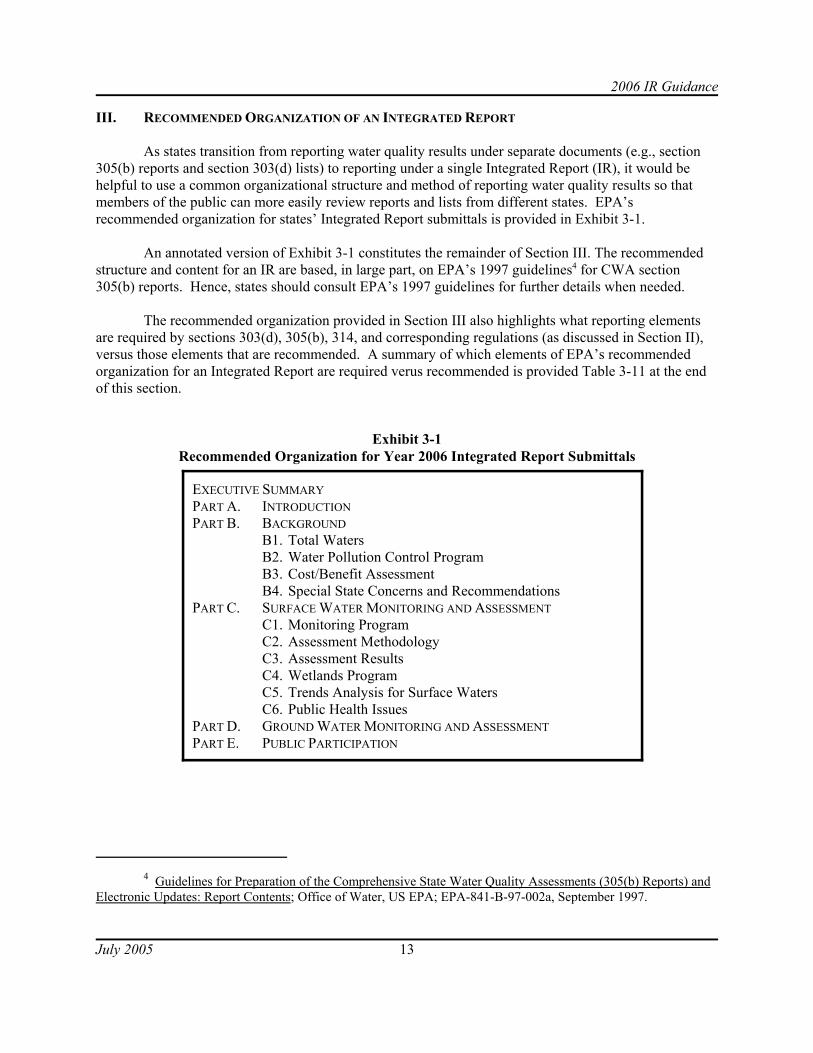
As states transition from reporting water quality results under separate documents (e.g., section 305(b) reports and section 303(d) lists) to reporting under a single Integrated Report (IR), it would behelpful to use a common organizational structure and method of reporting water quality results so thatmembers of the public can more easily review reports and lists from different states. EPA’srecommended organization for states’ Integrated Report submittals is provided in Exhibit 3-1.
An annotated version of Exhibit 3-1 constitutes the remainder of Section III. The recommendedstructure and content for an IR are based, in large part, on EPA’s 1997 guidelines4 for CWA section305(b) reports. Hence, states should consult EPA’s 1997 guidelines for further details when needed.
The recommended organization provided in Section III also highlights what reporting elementsare required by sections 303(d), 305(b), 314, and corresponding regulations (as discussed in Section II),versus those elements that are recommended. A summary of which elements of EPA’s recommendedorganization for an Integrated Report are required verus recommended is provided Table 3-11 at the endof this section.
Exhibit 3-1Recommended Organization for Year 2006 Integrated Report Submittals

2006 IR Guidance
5 “Waters of the United States” as defined in 40 CFR 122.2.
July 2005 14
EXECUTIVE SUMMARY
The Executive Summary should highlight the report’s major points of information, conclusionsand recommendation. States should include in this section a summary of the overall water quality(surface water and ground water) in the state, description of the causes and sources of water qualityimpairments, summary of the plan showing how the state will achieve comprehensive coverage of itswaters, discussion of the programs to correct impairments and discussion of the general changes or trendsin water quality.
In the summary of overall water quality status for surface waters, states may include the tablesrequested in Section C.3 (Assessment Results). States are also encouraged to include in this sectionsummary maps that depict water quality status information.
PART A. INTRODUCTION
The Introduction should include a narrative discussion that defines the purpose and contents ofthe 2006 Integrated Report. The Introduction may include a rationale for why the state has chosen tostreamline its reporting of water quality status (i.e., the results of placing segments into the fivecategories) and trends. The state may choose to explain why the use of this new reporting format willserve as a better mechanism to integrate CWA sections 303(d), 305(b), and 314 efforts in the state. Thestate may also choose to discuss how this integrated reporting format will clarify the complementary rolesof predictive tools (e.g., probability-based monitoring designs, models, and remote-sensing) and site-specific monitoring to assess water quality conditions.
States may also describe in the Introduction how they are ensuring the development of anintegrated database of assessment information that reflects the status of water quality standardsattainment. Specifically, the Introduction may discuss how the state may increase the amount ofassessment information that is geo-referenced and transmitted electronically through the ADB or acompatible data exchange format.
PART B. BACKGROUND INFORMATION
The Background section should include a description of total waters in the state, a description ofthe state’s water pollution control program, a cost/benefit analysis of actions necessary to achieve theobjective of the CWA, and any special state concerns and recommendations.
B.1 Scope of Waters in the Integrated Report
To put the report into perspective for the reader, the state should provide a brief water resourceoverview (as shown in Table 3-1) of all waters5 in the state. States are also encouraged to includesummary maps of water resource information in this subsection.

2006 IR Guidance
July 2005 15
Table 3-1. AtlasTopica Value Scaleb Sourcec
State Population N/A N/A
Total Miles of River and Streams . Miles of perennial rivers/streams (subset)
. Miles of intermittent (nonperennial) streams (subset). Miles of ditches and canals (subset). Border miles of shared rivers/streams (subset)
Number of lakes/reservoirs/pondsd
. Number of significant publicly owned lakes/reservoirs/ponds (subset)
Acres of lakes/reservoirs/ponds. Acres of significant publicly owned lakes/reservoir/ponds (subset)
Square Miles of estuaries/harbors/bays
Miles of Ocean Coast
Acres of Freshwater Wetlands
Acres of Tidal WetlandsNotes:
N/A Not applicable
a State may add categories to the atlas table to reflect special areas of interest (such as, acres of playas; acres ofriparian areas outside of wetlands; and miles of streams and acres of lakes on Tribal lands).
b State should specify the scale (e.g., 1:100,000; 1:24,000) in this column.
c State should specify the source (e.g., NHD, USGS quad maps, state inventory) in this column.
d Impoundments should be classified according to their hydrologic behavior, either as stream channel milesunder rivers or as total surface acreage under lakes/reservoirs/ponds, but not under both categories. Ingeneral, impoundments should be reported as lakes/reservoirs/ponds unless they are run-of-riverimpoundments with very short retention times.

2006 IR Guidance
July 2005 16
Please note, most of the tables in this section ask states to report on the extent, or size of waters. To clarify the source of these measurements, states should include in this subsection a description of theprocess used to make measurements of waters in the state. To promote national consistency inmeasurement and reporting, EPA recommends the use of the National Hydrography Dataset (NHD),which currently supports measurements at the 1:100,000 scale. Additional information on the NHD isavailable at www.epa.gov/owow/monitoring/georef/nhd.htm. EPA notes that many states are nowmaking measurements at the 1:24,000 scale. Therefore, for purposes of reporting measurements in theIntegrated Report, EPA asks that states indicate the scale at which the measurements were made.
B.2 Water Pollution Control Program
The state should provide a description of its approach to water quality management, includingoverviews of any watershed-based programs; the WQSs program; the point source control program; thenonpoint source control program; the TMDL program, and; program coordination with other state, tribal,and local agencies. States may also choose to highlight atmospheric deposition reduction strategies inthis subsection. As shown in Table 2-1, CWA section 305(b) and EPA’s implementing regulationsrequire states to provide the following information about their water pollution control programs:
• An estimate of the extent to which CWA control programs have improved water quality orwill improve water quality, and recommendations for future actions necessary andidentifications of waters needing action.
• A description of the nature and extent of nonpoint source pollution and recommendations ofprograms needed to control each category of nonpoint sources, including an estimate ofimplementation costs.
B.3 Cost/Benefit Assessment
As shown in Table 2-1, CWA section 305(b) (and associated regulations) also requires states toprovide an estimate of the environmental, economic and social costs and benefits needed to achieve theobjectives of the CWA and an estimate of the date of such achievement. EPA recognizes that thisinformation may be difficult to obtain due to the complexities of the economic analysis involved. Untilsuch time as comparable procedures for evaluation costs and benefits are in wider use, states shouldprovide a brief narrative that includes as much of the following information as possible.
For costs, EPA asks that states provide information on capital investments in municipal andindustrial facilities, investments in nonpoint source measures, annual operation and maintenance costs ofmunicipal and industrial facilities, total annual costs of municipal and industrial facilities, and annualcosts to states and local governments to administer water pollution control activities.
For benefits, EPA asks that states provide information on improvements in recreational andcommercial fishing; extent of stream miles, lakes acres, etc., improved from impaired to meeting WQSs;reduced costs of drinking water treatment due to cleaner intake water; and increase in use of beaches andrecreational boating due to improved water quality.

2006 IR Guidance
6 “Waters of the United States” as defined in 40 CFR 122.2.
July 2005 17
B.4 Special State Concerns and Recommendations
In this subsection, states should (1) discuss special concerns that are significant issues within thestate and that affect its water quality programs and (2) provide recommendations for actions that arenecessary to achieve the objectives of the CWA.
PART C. SURFACE WATER MONITORING AND ASSESSMENT
The Surface Water Monitoring and Assessment section should include a description of the state’smonitoring program, a description of the assessment methodology for classifying all surface waters,assessment results, a description of the state’s wetlands program, an analysis of surface water qualitytrends, and information on public health issues.
C.1 Monitoring Program
This subsection should include a description (or reference applicable documents) of the followingelements of the state’s monitoring program:
• Monitoring Program Strategy • Monitoring Objectives• Monitoring Design• Core and Supplemental Indicators• Quality Assurance• Data Management• Data Analysis/Assessment• Reporting• Programmatic Evaluation• General Support and Infrastructure Planning
EPA expects that states will develop, over time, a monitoring program that addresses the 10elements listed above. The first of these elements (monitoring program strategy) is currently underdevelopment by states and will include a timeline to complete implementation of all 10 elements by 2014. Additional guidance on these elements is available in EPA’s Elements of a State Water Monitoring andAssessment Program (US EPA, Office of Wetlands, Oceans, and Watersheds; EPA 841-B-03-003; March2003).
As shown in Table 2-1, CWA section 305(b) and EPA’s implementing regulations require statesto provide a description of the water quality of all waters6 in the States and the extent to which the qualityof waters provides for the protection and propagation of a balanced population of shellfish, fish, andwildlife and allows recreational activities in and on the water. As a result, EPA and the states haveestablished a long-term goal of comprehensively characterizing surface waters of each state using avariety of techniques. These techniques may include traditional targeted monitoring, probability-basedmonitoring surveys, targeted site-specific monitoring, landscape and water quality models, and remotesensing. States should include a description of their approach to comprehensive assessment in thissubsection.

2006 IR Guidance
7 “Waters of the United States” as defined in 40 CFR 122.2.
8 Although a description of the state’s assessment methodology is required, EPA does not approve ordisapprove the assessment methodology under CWA section 303(d).
July 2005 18
States should also include in this subsection a schedule that identifies the waters that will bemonitored and assessed during the next two-year reporting cycle. If this information is included in otherdocuments, such as the state’s section 106 workplan or a Performance Partnership Grant (PPG), the statemay provide a reference to that document. EPA does not expect that all waters will be scheduled formonitoring during the next two-year reporting cycle. This short-term monitoring schedule should beconsistent with the state’s monitoring priorities. The short-term monitoring schedule may presentupcoming monitoring activities planned under the long-term strategy, including the use of probability-based monitoring, landscape and water quality models, and targeted monitoring to predict and verifywater quality conditions. EPA intends that the monitoring schedule will inform stakeholders and EPA ofa state’s upcoming monitoring activities and will help promote collaboration and coordination amongmonitoring organizations.
C.2 Assessment Methodology
This subsection should include a description (or reference applicable documents) of the state'smethodology for assessing the water quality attainment status of all waters7 in the state. The assessmentmethodology should be consistent with the state’s WQSs and include a description of the following aspart of their section 303(d) list submissions:
• What data and information were used to make attainment determinations (e.g., results from site-specific and probabilistic monitoring and other predictive tools);
• How the data and information were used to make attainment determinations and place surfacewater segments in the five reporting categories;
• Rationales for any decision to not use any existing and readily available data and information;• Changes in the assessment methodology since the last reporting cycle.
Assessment methodologies that include the information listed above also satisfy the state’srequirements under CWA section 303(d) (and associated regulations) to provide the followinginformation as shown in Table 2-1: (1) a description of the methodology used to develop the section303(d) list, (2) a description of the data and information used to identify [impaired and threatened]waters, including a description of the existing and readily available data and information used, and (3) arationale for any decision to not use any existing and readily available data and information8.
EPA also encourages states to make the assessment methodology available to the public forreview and comment. Hence, states are encouraged to provide a description of the public participationprocess for the IR in this section, or reference their CPP as appropriate. Additional information ondevelopment/use of an assessment methodology and EPA’s five reporting categories is provided inSections IV and V of this guidance, respectively.

2006 IR Guidance
July 2005 19
C.3 Assessment Results
This subsection should present the results of the state’s surface water assessments, including thefive-part categorization of all surface water segments, probability-based survey results, the section 303(d)list, and State-level summaries of designated use support. In addition, states should satisfy CWA section314 (Lakes Program) reporting requirements in this subsection.
States should attempt to manage their assessment results in the Assessment Database (ADB) or acompatible data management system and submit them electronically with the Integrated Report. Thatsystem should provide the supporting information for this section. The summary tables provided in thissection can be generated directly out of the ADB and inserted into any word processing document.
Additional information on these reporting elements is provided below. How states organize thepresentation of their assessment results in hard-copy format is left to their discretion. For example, statescould organize their assessment results by the reporting elements italicized below, or by waterbody type(e.g., rivers/streams, lakes/ponds, estuaries/oceans, and wetlands). Five-Part Categorization of Surface Waters
States should assign all of their surface water segments to one or more of the five reportingcategories presented in Section V of this guidance. States should also include a summary of the extent ofsurface waters assigned to each reporting category as shown in Table 3-2.
Table 3-2. Sizea of Surface Waters Assigned to Reporting CategoriesWaterbody Type Category Total
in StateTotal
Assessed1 2 3 4a 4b 4c 5River/stream milesLake/pond acresEstuarine square milesOcean coast milesFreshwater wetland Tidal wetland acres
Note:a For states that place surface water segments in more than one reporting category, the summation of the size of
surface water segments assigned to the five reporting categories will be greater than the “Total in State”summation for each waterbody type. In such cases, EPA recommends that states provide a statement in the IRthat clarifies the discrepancy.
Results of Probability-based Surveys
States should report the results of probability-based surveys as shown in Table 3-3. EPA isworking on a supplemental module to the ADB for transmitting the results of probability-based surveys. Reporting the results is particularly important because probability-based surveys allow states to report onthe condition of the entire population of surface waters (e.g., coastal waters, rivers and streams, estuaries,etc.) included in the design. Site-specific assessment results will not result in an assessment of all surfacewaters, unless the state is able to implement a census.

2006 IR Guidance
July 2005 20
Table 3-3. Attainment Results Calculated Using Probabilistic Monitoring DesignsProject ID STX_1
Project Name Downstate Sample SurveyTarget Population All streams ordered 4 or greater
in basins C and DType of Waterbody RiverSize of Target Population 100Units of Measurement MilesDesignated_use Aquatic lifePercent_attaining 75%Percent_not_attaining 23%Percent nonresponse 2%Indicator BiologicalAssmt_date 20000201Precision 90%
Section 303(d) List
As shown in Table 2-1, The Clean Water Act and EPA regulations require states to submit thefollowing information as part of their section 303(d) list submission:
• A list of water quality-limited (impaired and threatened) waters still requiring TMDL(s)[waters assigned to Category 5], pollutants causing the impairment, and priority rankingfor TMDL development (including waters targeted for TMDL development within the nexttwo years).
• Any other reasonable information requested by EPA, such as demonstrating good causefor not including a water or waters on the list.
Although states are not required to provide “good cause” for each delisting prior to receiving aformal request from EPA, EPA recommends that states do so in the IR. States should highlight in thissubsection those segment/pollutant combinations that have been either added or removed since the lastreporting cycle and summary rationales (“good cause”) for each delisting. Table 3-4 provides arecommended format for summarizing delisting rationales in this subsection. States should providedetailed rationales for removing segment/pollutant combinations from their previous 303(d) lists in therecord of decision for the list.
States may also report on the status of their TMDL development by providing information such asthat found in Table 3-5 in this subsection or in the discussion of their Water Pollution Control Program(Section B.2).

2006 IR Guidance
July 2005 21
Table 3-4. Segment/Pollutant Combinations Removed from State’s Year 2004 Section 303(d) ListSegment/Pollutant
Combinationon Year 2004Section 303(d)
List
Segment(Waterbody)
ID
Summarya Rationale for Delisting ofSegment/Pollutant Combinations
(identify number of reason)1. State determines water quality standard is being
met2. Flaws in original listing3. Other point source or nonpoint source controls are
expected to meet water quality standards4. Impairment due to non-pollutant5. EPA approval of TMDL6. Waterbody not in state’s jurisdiction7. Other
Note:a Detailed justifications for removing waters from previous section 303(d) list should be provided in the
record of decision for the listing cycle in which the state proposes the water for removal.
Table 3-5. TMDL Development StatusSegment/Pollutant
Combination Segment ID Project StatusaProjected TMDLSubmittal Date
Note:a Under project status, states may provide a brief description of the status of TMDL development. This
could be done by providing a 1 or 2 word description of status (e.g., "completed", "in draft") or byproviding a more extensive description of status. For example, states may elect to include information onwhether the TMDL is being developed under court order deadline, whether supplemental monitoring isbeing performed, and when public meetings are scheduled to be held.
State Summaries of Designated Use Support
The state should provide designated use support summaries for each waterbody type, as shownin Table 3-6. States should include values for applicable designated use categories such as aquatic life,fish consumption, shellfishing, swimming, secondary contact, drinking water, agricultural, culturalceremonial, etc.
EPA recognizes that states may have site-specific results, as well as results of probabilitysurvey(s) that could be used to generate these results. When information from state-wide probabilitysurveys is available, that information should be used to complete Table 3-6 for the appropriatewaterbody type/use combination. Site-specific information should be used to provide designated usesummaries for waterbody types where probability-results are not available or to complement the results of probability-results that are not state-wide in scope. It is important that the state indicate whether thestate-wide numbers in Table 3-6 were generated via probability or site-specific surveys. In addition,states that report results based on probability surveys should complete Table 3-3 to provide additionalinformation. States should also include state-level summaries of causes and sources (when possible) ofimpaired waters as shown in Tables 3-7 and 3-8, respectively.

2006 IR Guidance
July 2005 22
Table 3-6. Individual Designated Use Support Summary (One Table for Each Waterbody Type)
Designated Use Size of Surface Waters
Total inState
TotalAssessed
Supporting –Attaining WQ
Standards
Not Supporting –Not Attaining
WQ Standards
InsufficientData and
InformationAquatic LifeState Defined1.2.Fish ConsumptionShellfishingSwimmingSecondary ContactDrinking Water State Defined1.2.Agricultural IndustrialCultural or Ceremonial State Defined1. 2.
Table 3-7. Size of Waters Impaired by Causes (One Table for Each Waterbody Type)
Cause/Impairment Type (Examplesa) from ADB Size of Waters Impaired Ammonia (unionized) Cause/Stressor UnknownChlorophyll aCopperEscherichia coliMercury pHPhosphorus TurbidityEtc.
Notes: a The parameters identified in this table are used as examples only. Please refer to the complete list of
causes available for reporting at http://www.epa.gov/waters/adb/

2006 IR Guidance
July 2005 23
Table 3-8. Size of Waters Impaired by Sources (One Table for Each Waterbody Type)
Source Category (Examplesa) from ADB Size of Surface Waters Impaired Industrial Point SourcesMunicipal Point SourcesCombined Sewer OverflowsUrban Runoff/Storm Sewers
Agriculture Crop production Rangeland grazingHydromodificationAtmospheric Deposition
Unknown SourceEtc.
Notes: a The parameters identified in this table are used as examples only. Please refer to the complete list of
sources available for reporting at http://www.epa.gov/waters/adb/
CWA Section 314 (Clean Lakes Program)
As shown in Table 2-1, states are required to submit the following information about the status ofpublicly owned lakes:
1. An identification and classification according to eutrophic condition of all publicly owned lakesin such state.
2. A description of procedures, processes, and methods (including land use requirements), tocontrol sources of pollution of such lakes
3. A description of methods and procedures, in conjunction with appropriate federal agencies, torestore the quality of such lakes
4. Methods and procedures to mitigate the harmful effects of high acidity, including innovativemethods of neutralizing and restoring buffering capacity of lakes and methods of removing fromlakes toxic metals and other toxic substances mobilized by high acidity
5. A list and description of those publicly owned lakes in such state for which uses are known to beimpaired, including those lakes which are known not to meet applicable water quality standardsor which require implementation of control programs to maintain compliance with applicablestandards and those lakes in which water quality has deteriorated as a result of high acidity thatmay reasonably be due to acid deposition
6. An assessment of the status and trends of water quality in lakes in such state, including but notlimited to, the nature and extent of pollution loading from point and nonpoint sources and theextent to which the use of lakes is impaired as a result of such pollution, particularly withrespect to toxic pollution.

2006 IR Guidance
July 2005 24
Table 3-9 provides a recommended format for reporting on the trophic status of significantpublicly owned lakes. States satisfy the requirement to provide a list of publicly owned lakes that areknown to be impaired by placing such waters in Category 5 and including them on the section 303(d) list. Table 3-10 provides a recommended format for reporting on trends in lake water quality. States maysatisfy the requirement to provide a trend analysis of water quality in lakes in this subsection or in TrendAnalysis for Surface Waters (Section C.5).
Table 3-9. Trophic Status of Significant Publicly Owned Lakes
Description Number of Lakes Acres of LakesTotal in state AssessedOligotrophicMesotrophicEutrophicHypereutrophicDystrophicUnknown
Table 3-10. Trends in Lake Water Quality
Description Number of Lakes Acres of LakesAssessed For TrendsImprovingStableDegradingFluctuatingTrend unknown
C.4 Wetlands Program
States may dedicate a section of their Integrated Report to providing a description of their wetlandsprogram if not already covered in another section of the Report. This section could include informationon development of wetland water quality standards, extent of wetland resources, integrity of wetlandsresources, and wetland protection activities.
C.5 Trend Analysis for Surface Waters
As discussed in Section C.3, states are required under CWA section 314 to report on lake waterquality trends. In addition to lake trends, states may also report on water quality trends for other surfacewaters in this section of the Integrated Report. To enhance states’ and EPA’s capability to perform waterquality trend analyses, states should routinely and comprehensively update STORET and ADB (orcompatible electronic data format).

2006 IR Guidance
9 Guidelines for Preparation of the Comprehensive State Water Quality Assessments (305(b) Reports) andElectronic Updates: Report Contents; Office of Water, US EPA; EPA-841-B-97-002a, September 1997.
10 Guidelines for Preparation of the Comprehensive State Water Quality Assessments (305(b) Reports)and Electronic Updates: Report Contents; Office of Water, US EPA; EPA-841-B-97-002a, September 1997.
July 2005 25
C.6 Public Health Issues
In this subsection, states should provide information on public health issues, including informationon their programs related to drinking water supplies, beach use, and fish/shellfish advisories. Fordrinking water programs, states should highlight the following information:
1. Total miles of rivers/streams and acres of lakes/reservoirs designated for drinking water use.2. For waters designated for drinking water use, miles of rivers/streams and acres of lakes/reservoirs
assigned to each of the five reporting categories.3. Summary of the methodologies used to perform drinking water use assessments under the Clean
Water Act, including the contaminants chosen for assessment and the rationale for theirselection. Note, states may reference their assessment methodology for this information.
4. Identification and extent of impaired miles of rivers/streams and impaired acres oflakes/reservoirs that overlap source water areas of community water systems as delineated bystates under SDWA section 1453.
States should consult Section 4, Chapter 8 (Public Water Supply/ Drinking Water Use Reporting)EPA’s 1997 guidelines9 for further details on reporting in this subsection.
PART D. GROUND WATER MONITORING AND ASSESSMENT
As discussed in Section II of this guidance, for states to be eligible for section 106 grant funds,section 106(e)(1) requires that states must have the means to monitor water quality (including “navigablewaters and to the extent practicable, ground waters”) and annually update water quality data and include itin their section 305(b) submittals. In this section, states should include a summary of their ground watermonitoring and protection programs, ground water quality, ground water contamination sources, andground water/surface water interactions. States should consult Section 5 (Ground Water Assessment)EPA’s 1997 guidelines10 for further details on reporting ground-water monitoring data.
PART E. PUBLIC PARTICIPATION
EPA regulations require states to describe in their Continuing Planning Processes (CPP) theprocess for involving the public and other stakeholders in the development of the section 303(d) list (40CFR 130.7(a)). EPA encourages the state to provide opportunities for public participation in thedevelopment of the Integrated Report and demonstrate how it considered public comments in its finaldecisions.
States should respond to commenters by including a responsiveness summary in their IntegratedReports or by making the summary available by other means used by the state (e.g., internet posting,mailing to commenters). States should submit or make available to EPA at the time of the IntegratedReport submittal a copy of all comment letters, e-mail, etc., received from the public and a responsivenesssummary addressing all comments. The responses should provide enough detail to clearly explain how

2006 IR Guidance
July 2005 26
the state considered the comment and whether and how the placement of waters in the five categorieschanged in response to the comment.
If the state received comments on a particular issue that opposes or questions the state's decisions,the Regions should determine whether those comments are adequately addressed in the state's commentresponse document. If the Region agrees with the state's substantive decision, but believes that the state'scomment response is inadequate, the Region can work with the state to supplement its response even afterthe formal submission is made (but prior to the Region's approval or disapproval action). If the state isunwilling or unable to supplement the state's responses, the Region should address the issue in its decisiondocument or elsewhere in the administrative record.

2006 IR Guidance
July 2005 27
Table 3-11. Summary of Water Quality Reporting Elements of an Integrated Report
Reporting Element Requireda () VersusRecommended ()
Executive Summary
Part A. Introduction
Part B. Background Information
B.1 Total Waters
B.2 Water Pollution Control Program See below
Description of water quality management program
An estimate of the extent to which CWA control programs have improved waterquality or will improve water quality, and recommendations for future actionsnecessary and identifications of waters needing action.
A description of the nature and extent of nonpoint source pollution andrecommendations of programs needed to control each category of nonpointsources, including an estimate of implementation costs.
B.3 Cost/Benefit Analysis
B.4 Special State Concerns and Recommendations
Part C. Surface Water Monitoring and Assessment
C.1 Monitoring Program
C.2 Assessment Methodology
Description of data and information was used to make attainment determinations
Description of how the data and information was used to make attainment determinations
Rationales for any decision to not use any existing and readily available data and information.
Description of changes in the assessment methodology since the last reporting cycle
C.3 Assessment Results b
(See below)
Assessment Database (ADB)c and georeferencing information
Five-part categorization of waters
Results of Probability-based designs
303(d) list: list of water quality-limited (impaired and threatened) waters still requiring TMDL(s) [waters assigned to Category 5], pollutants causing the impairment and priority ranking for TMDL development (including waters targeted for TMDL development within the next 2 years).
Changes from previous 303(d) list (i.e., the water/pollutants that have been added and the water/pollutants that have been delisted and the reason for their delisting)

2006 IR Guidance
Reporting Element Requireda () VersusRecommended ()
July 2005 28
Status of TMDL development
State summaries of designated use support
Eutrophic condition of all publicly owned lakes in such State
A description of procedures used to control pollution and restore water quality
Methods used to mitigate high acidity in lakes
A list and description of those publicly owned lakes in such State for which uses are known to be impaired and those lakes in which water quality has deteriorated as a result of high acidity that may reasonably be due to acid deposition
An assessment of the status and trends of water quality in lakes
C.4 Wetland Program
C.5 Trends Analysis
C.6 Public Health Issues
Part D. Ground Water Monitoring & Assessment
Part E. Public Participation See below
Description of public participation process
Copy of all comment letters, e-mail, etc., received from the public and aresponsiveness summary
Notes:
a Required by Clean Water Act sections 303(d), 305(b) or 314 and their corresponding regulations.
b CWA section 305(b) requires states to provide a description of the water quality of all waters in their state. As aresult, EPA and the states have established a long-term goal of comprehensively characterizing surface waters ofeach state using a variety of techniques. These techniques may include traditional targeted monitoring,probability-based monitoring surveys, targeted site-specific monitoring, landscape and water quality modeling,and remote sensing.
c EPA strongly encourages all states to use the ADB. If the state is not using the ADB, this assessment unit specificinformation should be submitted in a compatible electronic system. The state should work with EPA to ensurethat the electronic assessment information submitted can be compiled by EPA for regional and national reportingand can be sorted into the five part list as outlined in the IR guidance.

2006 IR Guidance
July 2005 29
IV. ISSUES CONCERNING THE DEVELOPMENT AND USE OF AN ASSESSMENT METHODOLOGY
A. What constitutes an assessment methodology?
The assessment methodology constitutes the decision process (including principles of science,statistics and logic used in interpreting data and information relevant to segment conditions) that a stateemploys to determine to which of the five integrated reporting categories a segment belongs. It isimportant that assessment methodologies must be consistent with applicable WQSs. They should also beconsistent with sound science and statistics.
As described in section 130.7 (b)(6) (i- iv), each state shall provide documentation to theRegional Administrator at the time that the integrated report or the separate section 303(d) list issubmitted. This documentation must support the state’s determination to list or not list its segments asrequired in 130.7(b)(1) and 130.7(b)(2). A major component of this documentation is a description of themethodology that the state used to develop their Integrated Report or the separate section 303(d) list.
The methodology should: 1) explain how the state identifies, considers (evaluates) all existingand readily available data and information; 2) articulate the basics of the quality assurance and qualitycontrol (QA/QC) criteria used to evaluate data submitted by outside entities to determine what weight, ifany, should be assigned to said data and information; and 3) explain the analytical approaches, includingstatistical analyses, used to infer true segment conditions from all valid existing and readily availableinformation. The decision processes the states describe in the methodology should provide allstakeholders with the opportunity to understand exactly how assessment decisions are made.
Prior to submission of its Integrated Report, each state should provide the public with theopportunity to review and comment on the methodology, consistent with their continuing planningprocess (CPP), public participation policies, and monitoring strategies.
B. What will EPA do with the methodology?
When a state has by rulemaking adopted a methodology as part of its approved water qualitystandards and the water quality standards are applicable for CWA purposes, 40 CFR § 131.21, EPA willapply the approved methodology as it reviews the state’s submission in order to determine whether toapprove or disapprove the section 303(d) list (Category 5). If a state has not by rulemaking adopted amethodology into its water quality standards, EPA will consider the state’s methodology, to the extentthat it reflects a reasonable interpretation of the state’s water quality standards and sound science, indetermining whether to approve or disapprove the section 303(d) list. In either scenario, EPA encouragesthe state to make available the most recent methodology used to develop the current Draft 2006 IntegratedReport (or separate 303(d) list) prior to submission of their IR. The methodology allows EPA and otherreviewers to understand the decision process followed by the states as they review the 2006 Draft. WhereEPA has concerns with the assessment methodology, EPA will provide comments to the state to assist indeveloping an approvable section 303(d) list.
For methodologies that are not part of the state’s applicable water quality standards, EPA willconsider the methodology as it assesses whether the state conducted an adequate review of all existingand readily available water quality-related information, whether the factors that were used to make listing

2006 IR Guidance
11 EPA notes that it does not view state regulatory provisions concerning assessment methods that merelydescribe the sufficiency or reliability of information necessary for states to make an attainment decision as waterquality standards, because they do not have the effect of changing the ambient conditions (i.e., magnitude, duration, frequency of concentrations of pollutants) considered necessary to support a designated use.
July 2005 30
and removal decisions were reasonable, whether the process for evaluating different kinds of water-quality related data and information is sufficient, and whether the process for resolving jurisdictionaldisagreements is sufficient. If EPA finds that the state’s methodology is inconsistent with its waterquality standards, and its application has resulted in an improper section 303(d) list, EPA may disapprovethe list. Regardless of the suitability of the methodology, EPA must review the list for consistency withthe relevant provisions of the CWA and the regulations.
EPA sees the methodology as an evolving document which states periodically revise asappropriate at some time during the listing cycle11. As such, EPA strongly encourages states to submittheir draft and current methodologies to EPA and to the public for review and comment (but not formalapproval) well in advance of any deadline the state sets for submission of data and information.
C. Data Assembly
40 CFR section 130.7(b)(5) requires that “Each State shall assemble and evaluate all existing andreadily available water quality related data and information to develop the list.”
States should solicit data and information including, but not limited to, the types listed below:
C observed effects (see glossary)C closures, restrictions and/or advisories applicable to swimming, fish consumption, and
drinking waterC violations of Safe Drinking Water Act (SDWA) standardsC segment-specific ambient monitoring-chemical, physical, and/or biologicalC large-scale probabilistic monitoring designsC simple dilution calculationsC predictive (simulation) modeling,C landscape analysisC remote sensingC complaints and comments from the public
To the extent practicable, such types of data and information should be drawn from existingcompilations of information regarding water quality, including, but not limited to:
C publicly-available databases (e.g., STORET)C source water assessments per the Safe Drinking Water ActC monitoring information from pesticides registrations C watershed plans and other kinds of water quality or natural resource management plansC Superfund Records of DecisionC reports prepared pursuant to sections 305(b), 303(d), 314, and 319 of the CWA
2006 IR Guidance
July 2005 31
Such types of data and information should also be solicited from a wide variety of organizationsand individuals, such as:
C other state agencies such as Fish and Wildlife, Parks, and Agriculture DepartmentsC federal agencies, including EPA, USGS, NOAA, USDA, and USFWS C local governmentsC drinking water utilities and state agencies responsible for SDWA implementationC universities and other research institutionsC environmental consulting firmsC National Pollutant Discharge Elimination System (NPDES) permittees C conservation/environmental organizationsC outdoor recreation organizationsC citizen monitoring groups
EPA regulations provide that states should actively solicit organizations and individuals such asthose listed above. See 40 CFR 130.7(b)(5)(iii). EPA considers active solicitation as notifying local,state, and federal agencies, members of the public, and academic institutions that the state is seekingwater quality related data and information for the purpose of developing the Integrated Report, throughnotices in the State Register, notices or announcements in appropriate local or trade papers, directmailings to members of the public that have previously submitted public comments or other interestedparties on the State's mailing list, or announcements and requests for data at appropriate public meetingsor informational meetings. EPA recommends that states also request such data and information via letterssent to other state agencies, federal agencies and academic institutions that may have data/information.
If the state has specifications for data and information, these specifications should be included inany requests for information. To facilitate the timely completion of a draft list that can be distributed forpublic review and comment, states may set a reasonable “cut-off” date after which no additional data orinformation will be considered in the preparation of the draft section 303(d) list and other aspects of apreliminary Integrated Report. If a state institutes a cutoff date for data submission, effective prior toestablishing a draft list, there could also be a separate data solicitation step prior to compilation of a final303(d) list. Under this scenario, the state would compile the preliminary list using all information it hasat hand based on identified data sources. Additional data submissions during the public comment periodwould then be evaluated, appropriate changes to the draft list would be made based on these new data orinformation.
If the state intends to consider only data and information submitted prior to a certain cutoff date,the state should clearly explain that this is the only opportunity for the public to provide data andinformation for the current assessment cycle, and that data submitted after that cutoff date would beconsidered during the next listing cycle. States should provide a mechanism for an exception to the limitfor the submission of data if the submitter can demonstrate that the data were readily available prior to thedata cutoff date and should have been included in any reasonably diligent state review of data. EPA willgenerally limit its review of a state listing submission to the data and information assembled by the stateprior to the data cutoff date if the state was reasonably diligent in assembling available data andinformation and soliciting data and information from the public.

2006 IR Guidance
July 2005 32
EPA is aware that many states have turned to the rotating basin strategy as a technically soundapproach for making assessment determinations of the state’s waters. In this approach, the availablemonitoring resources are concentrated or targeted in one portion of the state for a specified period of time,thus allowing for data to be collected and assessed in a spatially and temporally focused manner. Overtime, every portion of the state is targeted for this higher resolution monitoring and assessment effort(often over a five-year period), however the state must consider all existing and readily available data andinformation during the development of its 2006 Integrated Report, regardless of where in the state thedata and information were generated. The state should make reasonable efforts to obtain and consider sources of data and informationnot provided by commenters. If particular data/information referenced in the public comments are notprovided, EPA expects states to make a reasonable effort to secure the data. Solicitation requests shouldnote that at a minimum commenters should provide as much information as possible in order for the stateto be able to obtain the data or information, and again emphasize any state criteria for considering andprioritizing data sets. D. How should the methodology describe data and information expectations?
1. Data Quality Considerations
A state must evaluate all existing and readily available data and information, to establish how itshould be used in attempting to make a WQS attainment status determinations, applying reasonable andscientifically sound data evaluation procedures. Such evaluation protocols should strike a balancebetween: (1) employing only the very highest quality data, and (2) employing as much useful informationabout the condition of as many segments as possible. That is, these protocols should reflect bothlegitimate concerns about basing decisions on the best possible information and the fact that there isrelatively little or no segment-specific monitoring data or other forms of assessment-relevant informationavailable for the majority of the nation’s waters.
Such protocols/evaluation criteria would include typical elements of a quality assurance projectplan (QAPP). Examples of such elements include a description of the methods used to collect the data inthe field, a description of the methods to assure proper handling and “chain of custody” of the samplesduring transport to the laboratory, documentation of the laboratory methods used to perform the analysisof samples, and a description of any independent audits to verify the consistency of the data. In theirarticulation of QA/QC expectations for data and information submitted by others, states should describethe types and amount of metadata that should be provided along with specific sets of data andinformation. If an outside entity fails to provide necessary metadata along with submitted data andinformation, the state should attempt to obtain the metadata from the data-submitting organization beforeconcluding that the data and information is of low quality, simply due to lack of metadata.
Data quality criteria should be published along with any solicitations of data and information.Ideally, such QA/QC protocols should be made available to the public well in advance of any suchsolicitation for any given IR reporting cycle.

2006 IR Guidance
July 2005 33
In addition to articulating their data review criteria, EPA recommends that states work with data-generating organizations not only during the period of time just before the Integrated Reportdevelopment, but on a more continual basis, to help ensure their data are collected and stored in such away that the data will of high quality. States may wish to encourage such organizations to developQAPPs and submit them to the state for review and comment, and even perhaps formal approval by thestate. A state may elect to employ a rebuttable presumption that data and information submitted byorganizations with a state-approved QAPP meets the state’s QA/QC standards. Lack of a State-approvedQAPP should not, however, be used as the basis for summarily rejecting data and information submittedby such organizations, or assuming it is of low quality, regardless of the actual QA/QC protocolsemployed during the gathering, storage, and analysis of these data.
2. Data Representativeness Considerations
The spatial and temporal representativeness of data and information should be considered bystates as they attempt to characterize conditions in a given segment. Clearly, the degree of confidence ina WQS attainment status determination increases as the amount of data and information grows. Ideally, alldecisions about the WQS attainment status of individual assessment units would be based on a completecensus of water quality conditions, which could involve sampling every portion of a waterbody atfrequent intervals. Unfortunately, gathering this vast amount of data is not currently feasible, due to thelimitations of current monitoring technology as well as the amount of funding available for gathering andanalysis of water quality information.
Even for those segments where unusually large amounts of monitoring data is available,compared to most waterbodies, the percentage of all possible locations in time and space from which datahas been collected is very, very small. Given this situation, states and EPA will continue to need to makeWQS attainment status determinations by extrapolating, in time and space, to a substantial degree, fromindividual points of data.
Hence, state methodologies should describe, in general terms, the decision logic used todetermine the temporal and spatial extent a grab sample can be construed to represent. In order to makecredible assessment determinations, states should employ approaches that strike a balance between theextremes of: (1) considering every grab sample to be representative of merely the instant in which, andthe drop of water from which, each was taken; or, (2) assuming each such sample is representative ofconditions over several years, and covering hundreds of stream miles or hundreds of lake acres. (Notethat available data and information should be used to assess attainment of applicable water qualitystandards unless a specific technical rationale is provided to support a determination that such data andinformation should not be used (see 40 CFR 130.7(b)(6)(iii-iv)).
Many state numeric water quality criteria include multiple day averaging periods, while moststate monitoring programs do not collect samples at a rate of one or more per day. In such circumstances,states should decide how far out in time to extrapolate from the time at which a particular single grab wascollected. EPA recommends that such decisions be based on contextual information regarding conditionswhen and where the grab was taken. For example, such information might include: 1) precipitation, 2)streamflow, 3) location of point source discharges in relation to the monitoring site, 4) land use patterns inthe vicinity, 5) expected patterns of pollutant loading from the different kinds of sources present in the

2006 IR Guidance
July 2005July 2005 34
watershed, 6) occurrence of a chemical spill or other unusual event, and 7) historic patterns of pollutantconcentrations in the monitoring segment and/or waterbodies similar to it.
For instance, such contextual information might indicate that levels of a pollutant under study arelikely to have remained fairly constant over a certain period. This would generally be a reasonableconclusion if, for example, available information suggested that both pollutant loadings and stream flowremained fairly steady over that period. In such cases, it could be reasonable to assume that theconcentration seen in a sole available grab sample was representative of average conditions over theperiod of interest. On the other hand, if it were known that the watershed draining into a segment had alarge number of precipitation-dependant sources of pollutants, a particular sample had been collectedduring the only significant rainfall that occurred during that period, and the precipitation event was of aduration shorter than the averaging period used in the water quality standard, then it could make sense toconclude that the concentration in that sample was not roughly equal to the average over the period inquestion (e.g., 1 day, 4 days, 7 days).
Similarly, contextual information can help inform a decision as to how far out in space toextrapolate from a particular sampling point. Where no point source dischargers are present and land usepractices are the same over large areas, assuming data collected at a particular monitoring site isrepresentative of conditions over a long stretch of river could be reasonable. On the other hand, if anumber of point sources and a variety of nonpoint sources are found along a similar length of stream, itmay be prudent to presume that data from a particular sampling site is representative of only a portion ofthat river reach.
In deciding how broad a span of time and space to assume a particular grab sample mightrepresent, States may wish to consider the implications of a more expansive versus a more cautiousapproach to interpreting available monitoring data in the context of available metadata. Willingness toextrapolate further in time and space will generally lead to making WQS attainment/non-attainmentdeterminations on a larger number of waters and designated uses, while a more cautious approach canresult in a higher proportion of waters and uses being reported as “status unknown”.
Though a determination of whether a single grab sample can reasonably be construed to berepresentative of (i.e., close in value to) average conditions over a specified period is an important step inthe assessment process, the mere fact that the only grab sample available for a particular period is notdeemed representative of average conditions over said period does not necessarily mean that it could notbe used as the basis of a WQS attainment status determination. For instance, despite being non-representative of the average concentration, it may be indicative of the average, or at least a fairly reliableindicator of whether or not the average concentration in the waterbody over said period is above or belowthe level specified in the WQS.
For example, it is widely known that dissolved oxygen levels rise and fall in most waterbodiesfollowing a diurnal cycle. Hence, if a grab sample were collected at 5 a.m. (around when DO levelsshould be at the lowest point during the daily cycle) and the DO level in the sample was above, or evensomewhat below, the level specified in an applicable WQC expressed as a 24 hour average concentration,it would be reasonable to assume the daily average concentration of DO on the day the one grab wascollected was higher than that specified by the WQC. (Conversely, if a DO sample were collected at6p.m., i.e., during the high end of the diurnal cycle of DO levels, and the concentration was below, or

2006 IR Guidance
12 Another example of using data sets consisting of just one grab sample to make inferences aboutconditions over longer periods is illustrated by one aspect of the 1986 EPA water quality criteria document forbacteria (www.epa.gov/waterscience/beaches/1986crit.pdf).
July 2005July 2005 35
even slightly above, the specified concentration, it could be reasonable to conclude that the 24-houraverage DO level was below that specified by the WQC.)12
Awareness of the types of sources upstream of a site and knowledge of the weather at the time ofsampling can also be instructive. For instance, if the level in the sole grab of a pollutant associatedprimarily with nonpoint sources was slightly higher than the criterion-concentration, but the grab hadbeen taken during a one-in-10-year one-hour rainfall event, it could be reasonable to assume the 4-dayaverage was lower than the criterion-concentration.
Similarly, EPA believes that data should not automatically be treated as unrepresentative ofrelevant segment conditions solely on the basis of its age without supporting information indicating thatthe data are not a good indicator of current conditions. However, older data should be evaluated withcare. For example if the most recent data for a particular assessment unit is 10 years old, and that dataindicated that average and/or peak conditions in a segment at that time were worse than those specified byan applicable WQC; and, since that time, all the sources of the pollutant in question had been required todramatically lower the levels of the pollutant in their effluent, and few changes that would lead toincreased loadings of the pollutant had taken place in the watershed, it could be reasonable to assume thatthe segment was now meeting the WQC for that pollutant. By contrast, if 15 year old data indicated thata segment was then just barely meeting WQS for several pollutants associated with urban runoff, and thewatershed of that segment had since that time undergone considerable urbanization, a conclusion that thesegment was no longer meeting WQC for some or all of those pollutants could be warranted.
States should be cautious about employing assessment methodologies that assign little or noweight to data consistent with state QA/QC protocols based on the theory that it is “unrepresentative”simply because the data seem to reflect unusual circumstances. Rather, such unusual circumstancesshould be evaluated in the context of the specific requirements of applicable WQSs. In assessingpotential adverse effects on humans or other life forms, it is just as important to be cognizant of potentialshort term events as it is to reflect longer term “average” conditions. Short term exposure to very highlevels of pollutants (or low level of necessary elements like oxygen) can be extremely harmful, evenlethal. For this reason, EPA and state WQC for a number of pollutants include concentration/durationcombinations for short periods as well as such combinations for longer periods. Such criteria aretypically referred to as acute and chronic WQC, respectively.
Extreme values or “outliers” can be very relevant when dealing with WQC aimed at protectinghumans or other life forms against adverse effects of acute (short term) exposure to pollutants. The factthat such values may occur fairly infrequently and are not representative of long term average conditionsis unimportant when dealing with WQC expressed as short-term that should occur only rarely, if ever. EPA’s WQC addressing acute exposure of freshwater aquatic life to toxic chemicals are an example ofWQC expressed in this way – they are one-hour average concentrations that should be surpassed no morethan once every three years on average. WQC expressed as instantaneous concentrations never to besurpassed address even more rare, but nevertheless harmful, conditions.

2006 IR Guidance
July 2005July 2005 36
Caution regarding exclusion of “outliers” is expressed in EPA’s Guidance for Data QualityAssessment: Practical Methods for Data Analysis (QA/G-9) (EPA/600/R-96/084) published in July 2000,available at http://www.epa.gov/quality/qa_docs.html):
“One should never discard an outlier based solely on a statistical test. Instead, the decision todiscard an outlier should be based on some scientific or quality assurance basis. Discarding anoutlier from a data set should be done with extreme caution, particularly for environmental datasets, which often contain legitimate extreme values. If an outlier is discarded from the data set,all statistical analysis of the data should be applied to both the full and truncated data set so thatthe effect of discarding observations may be assessed. If scientific reasoning does not explain theoutlier, it should not be discarded from the data set.” (EPA/600/R-96/084, pp. 4-26).
Additional guidance about “outliers” can be found in the discussion of trimmed means on page 35of Biological Criteria: Technical Guidance for Survey Design and Statistical Evaluation of BiosurveyData (EPA/822/B/97/002).
However, disregarding valid data gathered during extreme conditions (e.g., significant droughtsor floods) can be appropriate if applicable state’s WQS include a provision specifying that some or allWQC do not apply during certain rare events, such a 7Q10 low (or high) stream flow. Also, datacollected at certain times of years could legitimately be disregarded when making use support statusdeterminations based on seasonal WQC – ones that apply only to times of year other than that when theseparticular data were collected.
In addition to such “temporal waivers” of WQS, state regulations often contain “spatial wavers”–portions of segments in which some or all WQS do not apply. Mixing zones in the immediate vicinity ofNPDES-regulated discharges are the most common example of such exemptions. Hence, data collectedwithin the confines of designated mixing zones should not be applied against some or all WQC otherwiseapplicable to the receiving segment.
3. Data Quantity Considerations
EPA encourages the collection of adequate data to make well-grounded attainmentdeterminations. EPA has not established, required, nor encouraged the establishment of rigid minimumsample set size requirements in the WQS attainment status determination process. EPA is particularlyconcerned with application of such thresholds state-wide, without regard to key factors like the manner inwhich applicable WQC are expressed, variability in segment-specific conditions, and fluctuations in ratesof pollutant loading. Rather if employed, target sample set sizes should not be applied in an assessmentmethodology as absolute exclusionary rules, and even the smallest data sets should be evaluated and, inappropriate circumstances, used. While it may be appropriate to identify target sample sizes as amethodology is developed, states should not exclude from further consideration data sets that do so solelybecause they not meet a target sample size. A methodology may provide for an initial sample size screen,but should also provide for a further assessment of sample sets that do not meet the target sample size. (EPA suggests that states avoid setting target sample set sizes higher than the amount of data available atmost sites.)

2006 IR Guidance
July 2005July 2005 37
Assessments based on larger sample sets are more likely to yield accurate conclusions thanassessments based on smaller sample sets. For example, smaller sample sets are more prone to lead toerroneously concluding that at a WQC has not been exceeded, because they result in a lower probabilityof detecting WQSs exceedances that have actually occurred. (EPA, Consolidated Assessment and ListingMethodology – Toward a Compendium of Best Practices (CALM) July 2002, pp. 4-9).
Any target sample set size thresholds must be consistent with the state’s EPA-approved waterquality standards. Hence, when making an determination based on comparison of ambient data and otherinformation to a numeric WQC expressed as an “average” concentration over a specified period of time, astatement of a desired number of samples may be appropriate. Still, the methodology should providedecision rules for concluding nonattainment in cases where the target data quantity expectations are notmet, but the available data and information indicate a reasonable likelihood of a WQC exceedance (e.g.,available samples with major digressions from the criterion concentration, corroborating evidence fromindependent lines of evidence such as biosurveys or incidence of waterborne disease, indications thatconditions in the waterbody and loadings of the pollutant into the waterbody have remained fairly stableover the period in question).
Even a very small set of samples may be sufficient to indicate impairment, particularly when theduration/averaging periods of relevant WQC are quite short (an hour or less). For example, one grabsample meeting QA/QC specifications with a concentration higher than the criterion - concentration for atoxic compound could well be grounds for concluding that a WQC expressed as a concentration not besurpassed at any time had been exceeded. A single sample with a concentration that digressed from (wasabove) the criterion-concentration would be a particularly strong indicator of exceedance of such acriterion if it was the only sample that had been collected. In such a situation, the rate of digression in thesample set (in this instance a set of one) was 100%. This means that, if the timing of the sample waspicked randomly, the chances are good that if additional samples had been taken over the period ofconcern, the vast majority of those would also have had concentrations above the criterion-concentration. (Of course, if the sole sample were collected during a time, condition and/or location condition excludedfrom application of said WQC, by the state’s WQS regulation, it would not be an appropriate basis for303(d)-listing a segment. Commonly encountered examples of such exclusions include streamflowsbelow the low-flow 7Q10 or areas inside the designated mixing zone for an NPDES permittee.) NOTE:See Sec. IV.D.2 for discussion of a somewhat different issue regarding use of single grab samples.
4. Providing Excluded Data (considered and evaluated, but not used) to EPA
EPA regulations require states to provide as part of their section 303(d) list submission a rationalefor not using any existing and readily available water quality-related data and information in developingthe list. 40 CFR 130.7(b)(6)(iii). EPA recommends that states provide such a rationale on a segment-specific basis to assist EPA in reviewing the state’s listing decisions. EPA may also request that states provide any data or information they decided not to use to develop their list and a case-specific rationalefor that decision to not use the data in a particular WQS attainment status determination. EPA mayreview the data and rationale, disapprove section 303(d) listing decisions if appropriate, and makechanges in the section 303(d) list based on data and information that was improperly excluded. Failure bya state to provide a reasonable technical rationale for a specific determination or for a decision not to useparticular data or information may result in partial disapproval of the list for failure to include segments inCategory 5, and potential additions of segments to the section 303(d) list by EPA.

2006 IR Guidance
July 2005July 2005 38
E. Should a state use information other than site-specific ambient monitoring data?
Yes, as appropriate. Categorization decisions should generally not be based only on site specificambient monitored data, and what was directly observed in the limited set of samples available to thewater quality assessor, when other relevant types of information are available. For example, EPAregulations require that “reports from dilution calculations and predictive modeling” be included in thedata and information that a state considers in its assessment process for section 303(d) listing (Category 5)purposes (40 CFR 130.7(b)(5)(ii)). Likewise, it may be appropriate to place a segment in any of the otherfour IR categories based on assessments resulting from the consideration of assessment tools such aspredictive modeling, remote sensing data, land use analysis, knowledge about pollutant sources andloadings, observed effects, etc. (see longer listing of types of data and information in Sec. IV, Part C).
EPA believes that a valid assessment of a segment’s condition should involve drawingconclusions beyond those which would be arrived at by taking into account nothing more that what wasdirectly observed in the fraction of all possible segment conditions over a given span of time and volumeof space represented by a typical set of ambient data. Simple dilution calculations, for example, can beused to estimate what concentration of a pollutant might be present under conditions (e.g., streamflow,pollutant loads) different from those extant at the times sampling was performed.
F. How should states use results of probability-based monitoring?
States should report the results of probability-based assessments as a component of theirIntegrated Report. A probability-based monitoring design is a type of sample survey design that ensuresmonitoring at a representative set of sample sites from which inferences can be made about the largerpopulation or resource under investigation (e.g., rivers and streams throughout a state or watershed). It issimilar to an opinion poll in which a sample of people are selected at random to represent a largerpopulation. Probability-based designs are used in a wide range of disciplines when conducting a census(e.g., sampling every stream mile) is not economically feasible or is not necessary.
States are encouraged to use probability-based monitoring designs for developing probabilisticstatements about waterbody conditions over broad scales (basins, the entire state). EPA believes that aprobability-based monitoring design applied over large areas, such as an entire state or a large watershed,is a cost-effective approach to producing a statistical statement, of known confidence, describing theaggregate condition of water resources. For instance, based on such a study, a state might be able to state,with 75% confidence, that 37% of lakes of 50 acres or less fail to meet WQC for total phosphorus.
In addition, sampling performed under probability-based surveys provides site-specific data abouteach sample location. These data should be considered along with any other site-specific data that mightbe available, to determine if they should be used to make WQS attainment status determinations, leadingto placing segments in the five categories.

2006 IR Guidance
13 There are a variety of definitions for the term “conventional pollutants.” Wherever this term is referredto in this guidance, it means “a pollutant other than a toxic pollutant.”
July 2005July 2005 39
The results of probability-based monitoring provide a useful benchmark for the extent thatsegments are likely to be healthy or degraded. This may help states refine their understanding of howmuch additional targeted monitoring is needed to complete identification of segments needing restoration,as well as high quality waters needing extra protection.
Though probability-based monitoring programs usually result only in a statistical statement, ofknown confidence, about aggregate waterbody conditions across a large area, in some instances, resultsmay be compelling enough to support site-specific decisions about water quality in segments besidesthose from which ambient data were collected. For example, if a probability-based survey of fish tissuefrom a random sample of lakes across a state found, with a reasonably high level of confidence, that avery high percentage of lakes contain fish with tissue contaminant concentrations exceeding advisorylevels, decision makers might decide to list all of the state’s lakes as impaired for fish consumption useHowever, see Section V.H.6 below for additional guidance on use of fish consumption advisories inattainment determinations. For more information on the design and implementation of probability-basedsample surveys, visit EPA's Aquatic Resource Monitoring web page athttp://www.epa.gov/nheerl/arm/index.htm.
G. How should statistical approaches be used in attainment determinations?
The state’s methodology should provide a rationale for any statistical interpretation of data for thepurpose of making an assessment determination.
1. Description of statistical methods to be employed in various circumstances
The methodology should provide a clear explanation of which analytic tools the state uses andunder which circumstances. EPA recommends that the methodology explain issues such as the selectionof key sample statistics (arithmetic mean concentration, median concentration, or a percentile), null andalternative hypotheses, confidence intervals, and Type I and Type II error thresholds. The choice of astatistic tool should be based on the known or expected distribution of the concentration of the pollutantin the segment (e.g., normal or log normal) in both time and space.
Past EPA guidance (1997 305(b) and 2000 CALM) recommended making non attainmentdecisions, for “conventional pollutants” — TSS, pH, BOD, fecal coliform bacteria, and oil and grease13
— when more than “10% of measurements exceed the water quality criterion.” (However, EPA guidancehas not encouraged use of the “10% rule” with other pollutants, including toxics.) Use of this rule whenaddressing conventional pollutants, is appropriate if its application is consistent with the manner in whichapplicable WQC are expressed. An example of a WQC for which an assessment based on the ten percentrule would be appropriate is the EPA acute WQC for fecal coliform bacteria, applicable to protection ofwater contact recreational use. This 1976-issued WQC was expressed as, “...no more than ten percent ofthe samples exceeding 400 CFU per 100 ml, during a 30-day period.” Here, the assessment methodologyis clearly reflective of the WQC.

2006 IR Guidance
July 2005July 2005 40
On the other hand, use of the ten percent rule for interpreting water quality data is usually notconsistent with WQC expressed either as: 1) instantaneous maxima not to be surpassed at any time, or 2)average concentrations over specified times. In the case of “instantaneous maxima (or minima) never tooccur” criteria use of the ten percent rule typically leads to the belief that segment conditions are equal orbetter than specified by the WQC, when they in fact are considerably worse. (That is, pollutantconcentrations are above the criterion-concentration a far greater proportion of the time than specified bythe WQC.) Conversely, use of this decision rule in concert with WQC expressed as averageconcentrations over specific times can lead to concluding that segment conditions are worse than WQC,when in fact they are not.
If the state applies different decision rules for different types of pollutants (e.g., toxic,conventional, and non-conventional pollutants) and types of standards (e.g., acute vs. chronic criteria foraquatic life or human health), the state should provide a reasonable rationale supporting the choice of aparticular statistical approach to each of its different sets of pollutants and types of standards.
2. Elucidation of policy choices embedded in selection of particular statistical approaches and useof certain assumptions
EPA strongly encourages states to highlight policy decisions implicit in the statistical analysisthat they have chosen to employ in various circumstances. For example, if hypothesis testing is used, thestate should make its decision-making rules transparent by explaining why it chose either “meeting WQS”or “not meeting WQS” as the null hypothesis (rebuttable presumption) as a general rule for all waters, acategory of waters, or an individual segment. Starting with the assumption that a water is “healthy” whenemploying hypothesis testing means that a segment will be identified as impaired, and placed in Category4 or 5, only if substantial amounts of credible evidence exist to refute that presumption. By contrast,making the null hypothesis “WQS not being met” shifts the burden of proof to those who believe thesegment is, in fact, meeting WQS.
Which “null hypothesis” a state selects could likely create contrasting incentives regardingsupport for additional ambient monitoring among different stakeholders. If the null hypothesis is“meeting standards,” there were no previous data on the segment, and no additional existing and readilyavailable data and information are collected, then the “null hypothesis” cannot be rejected, and thesegment would not be placed in Category 4 or 5. In this situation, those concerned about possibleadverse consequences of having a segment declared “impaired” might have little interest in collection ofadditional ambient data. Meanwhile, users of the segment would likely want to have the segmentmonitored, so they can be ensured that it is indeed capable of supporting the uses of concern. On theother hand, if the null hypothesis is changed to “segment not meeting WQS,” then those that would preferthat a particular segment not be labeled “impaired” would probably want more data collected, in hopes ofproving that the null hypothesis is not true.
Another key policy issue in hypothesis testing is what significance level to use in decidingwhether to reject the null hypothesis. Picking a high level of significance for rejecting the null hypothesismeans that great emphasis is being placed on avoiding a Type I error (rejecting the null hypothesis, whenin fact, the null hypothesis is true). This means that if a 0.10 significance level is chosen, the state wantsto keep the chance of making a Type I error at or below ten percent. Hence, if the chosen null hypothesis

2006 IR Guidance
July 2005July 2005 41
is “segment meeting WQS,” the state is trying to keep the chance of saying a segment is impaired – whenin reality it is not – under ten percent.
An additional policy issue is the Type II errors (not rejecting the null hypothesis, when it shouldhave been). The probability of Type II errors depends on several factors. One key factor is the number ofsamples available. With a fixed number of samples, as the probability of Type I error decreases, theprobability of a Type II error increases. States would ideally collect enough samples so the chances ofmaking Type I and Type II errors are simultaneously small. Unfortunately, resources needed to collectsuch numbers of samples are quite often not available.
The final example of a policy issue that a state should describe is the rationale for concentratinglimited resources to support data collection and statistical analysis in segments where there aredocumented water quality problems or where the combination of nonpoint source loadings and pointsource discharges would indicate a strong potential for a water quality problem to exist.
EPA recommends that, when picking the decision rules and statistical methods to beutilized when interpreting data and information, states attempt to minimize the chances of making eitherof the two following errors:
• Concluding the segment is impaired, when in fact it is not, and• Deciding not to declare a segment impaired, when it is in fact impaired.
States should specify in their methodology what significance level they have chosen to use, invarious circumstances. The methodology would best describe in “plain English” the likelihood ofdeciding to list a segment that in reality is not impaired (Type I error if the null hypothesis is “segment not impaired”). Also, EPA encourages states to estimate, in their assessment databases, the probability ofmaking a Type II error (not putting on the 303(d) list a segment that in fact fails to meet WQS), when: 1)commonly-available numbers of grab samples are available, and 2) the degree of variance in pollutantconcentrations are at commonly encountered levels. For example, if an assessment is being performedwith a WQC expressed as a 30-day average concentration of a certain pollutant, it would be useful toestimate the probability of a Type II error when the number of available samples over a 30 day period isequal to the average number of samples for that pollutant in segments state-wide, or in a given group ofsegments, assuming a degree of variance in levels of the pollutant often observed over typical 30 dayperiods.
H. How should states use community-level bioassessment data?
Many states use multi-metric, community-level biological assessments to report water resourcecondition. Biological assessments provide direct measures of the cumulative response of the biologicalcommunity to all sources of stress. Therefore, a biocriteria/bioassessment represents a very usefulindicator of the use support status for aquatic life.
Credible assessments of biological condition can be accomplished with far fewer samples thanwith parameter-specific monitoring. However, attention to proper quality assurance and control is equallyimportant in biological monitoring as it is in chemical and physical measurements. Threshold values forsegment impairment determinations as well as quality assurance should be addressed in the state’smethodology.

2006 IR Guidance
July 2005July 2005 42
States should include biological assessments in the data and information they assemble andevaluate in developing their Integrated Reports, and must provide a rationale for any decision not to usethe assessments in developing their section 303(d) lists.
States using biological assessments to make reporting determinations should also consider othertypes of data and information (i.e., chemical and physical). In instances in which the indication of aquaticlife use support provided by biosurvey data and that provided by chemical and/or physical data differ,EPA continues to support the principle of independent applicability (see Section IV.K. below), as mostrecently articulated in its Consolidated Assessment and Listing Methodology guidance.
I. What information should the state provide regarding its interpretation of its WQS?
When deciding whether to put a segment in Category 1, 2, 4 or 5, a state is trying to answer thequestion, “What does available ambient monitoring data and other information tell us about whether ornot this segment is meeting WQS?” In order to answer this question, it is necessary to be very clear aboutthe WQS that apply to the segment– the DUs assigned to the segment, as well as the numeric waterquality criteria (WQC) applicable to each DU, along with narrative WQC.
Ideally, states’ WQS regulations will clearly articulate each DU and all WQC applicable to thatDU. However, in some instances, there may be ambiguity in the way WQS are expressed. For example, aWQC could refer to an “average” concentration. This could mean the median, the arithmetic mean, thegeometric mean, or something else describing a central tendency. Also, WQS regulations and guidancesometimes do not clearly state a duration component of a WQC (criterion-duration) – particularly sometypes of human health (HH) criteria. (For reference purposes: EPA HH criteria for carcinogens arepresumed to have a duration of a year or more; whereas a duration of 30 days is employed in criteriaaddressing human pathogens and water contact recreation. EPA’s aquatic life WQC for toxic chemicalspresent acute and chronic concentrations applicable to exposure durations of (a) 1 hour and (b) 4 days,respectively.)
For toxic (“priority” pollutants) and protection of freshwater aquatic life, EPA guidancerecommends use of a once in three year maximum allowable excursion recurrence frequency (Guidancefor 2004 Assessment, Listing and Reporting Requirements Pursuant to Sections 303(d) and 305(b) of theClean Water Act, Section III (F), EPA, 2003). Hence, for example, if a state freshwater aquatic lifeWQC were expressed as “1-hour average concentration not to surpass 22 ug/L”, EPA would assume anapplicable excursion frequency of no more than once in 3 years.
J. How should states handle shared waters?
States with shared waters should make every effort to coordinate with each other in thedevelopment of their Integrated Reports. Coordination should occur early in the process. Wherepossible, states should work together to collect, assemble, solicit, and assess all readily available data andinformation relevant to the shared waters. Assessments for waters that are shared by neighboring statesshould be as consistent as possible. This is particularly important for segments listed in Category 5. However, differing state WQS can make consistent attainment decisions difficult. In such cases, EPA

2006 IR Guidance
14Part K of Section IV has been adapted from pages 3-9 to 3-10 of EPA’s Consolidated Assessment andListing Methodologies (CALM), July 2002.
July 2005July 2005 43
Regional offices and interstate commissions, where applicable, should assist in resolving inconsistencieswhen they arise. The Integrated Report should document the coordination that has occurred betweenneighboring states and interstate commissions.
Some interstate commissions are required to prepare a section 305(b) report, but the responsibilityof preparing Integrated Reports and section 303(d) lists rests with the states. Data and information in aninterstate commission section 305(b) report should be considered by the states as one source of readilyavailable data and information when they prepare their IR and make decisions on segments to be placedin Category 5; however, data in a section 305(b) interstate commission report should not be automaticallyentered in a state IR or section 303(d) list without consideration by the state about whether such inclusionis appropriate. EPA has made the necessary modification to its ADB system to ensure that interstatecommission data stays segregated from state data.
K. How does the state make attainment decisions when different types of data indicate adifferent attainment status?14
To address the possibility of conflicting results among different types of data used to assessattainment with WQS, EPA recommends that states apply the policy on independent applicability asappropriate for making WQS attainment decisions. This policy was initially crafted to addressdevelopment of NPDES permit discharge limits. Its use is slightly different in the context of WQSattainment decisions.
The intent of this policy is to protect against dismissing valuable information when evaluatingaquatic life use support, particularly in detecting impairment. EPA’s policy on independent application isbased on the premise that any valid, representative dataset indicating an actual or projected water qualityimpairment should not be ignored when one is determining the appropriate action to be taken. However,EPA recognizes that there are circumstances when conflicting results should be investigated furtherbefore the attainment or nonattainment decision is made. For example, states may obtain multipledatasets of varying quality, which may influence the reliability of the assessment results.
Figure 4-1 elaborates on the use of the independent application policy in reconciling conflictingresults among different datasets used to assess attainment with aquatic life-based WQS. The decisionprocess begins in the upper left of Figure 4-1. When a state, territory, or authorized tribe has two or moretypes of data that do not indicate consistent attainment status, it should determine whether differences inassessment results can be attributed to differences in the quality of the datasets. For example, this mayinvolve consideration of analytical methods, review of sampling techniques, and detailed assessment ofdatasets. When the differences are due to data quality issues, the independent application policy allowsfor resolving the differences by cleaning the data or weighing the higher quality dataset more favorably inthe attainment decision.

2006 IR Guidance
July 2005July 2005 44
When detailed data analysis fails to identify data quality issues that explain the discrepancies,site-specific environmental conditions should be considered (e.g., effects of water chemistry, or the abilityof species to adapt over time). Site specific WQC may be explored via application of the water effectsratio, resident species recalculations, or other appropriate methods.

2006 IR Guidance
July 2005July 2005 45
T h e r e a r e a c o m b in a t io n o f 2 o r m o r e ty p e s o f d a ta (e .g . p h y s ic a l, c h e m ic a l, b io lo g ic a l, & to x ic o log ic a l)
D o th e s e d a ta in d ic a te c o n s is te n ta tta in m e n t s ta tu s
C a n d if fe r e n c e s b e a ttr ib u te d to a n a r tifa c t o f d a ta y o u h a v e (e .g . d a ta q u a n tity a n d q u a lity )?
-a n a ly t ic a l m e th o d s?-s a m p lin g te c h n iq u e ?-s ta tis tic a l c o n f id e n c e ?
C a n d if f e r e n c e s b e a ttr ib u te d to a n e n v ir o n m e n ta l fa c to r ?
- W a te r e f f e c ts r a tio? - S p e c ie s p r e s e n c e /a b s e n c e ? - S tr e s s or s (S IE ) ?
C la s s ify A tta in m e n t
S ta tu s
C a n y o u r e s o lv e ?- C le a n -u p D a ta- e tc .
C a n y o u r e s o lv e ? - S ite s p e c if ic C r ite r ia - N e w C r ite r ia
D e la yC la s s if ic a tio n
W ith m o r em o n ito r in g d a ta
C la s s ifyA tta in m e n t S ta tu s
D e la yC la s s if ic a tio n
S E N D E X A M P L E S !
N O
N O
S E N D E X A M P L E S
N O
Y e s
Y e s
Y e s
Y e s
Y e s
N O
N O
Figure 4-1. Using Multiple Types of Data to Assess Attainment
For Purposes of WQS Attainment/Nonattainment Determinations:
Policy of independent applicability says:
• When evaluating multiple types of data (e.g., biological, chemical) and any one type of dataindicates an element of a WQS is not attained, the segment should most likely be identified asimpaired.
• If there is reason to doubt the nonattainment finding, re-evaluate all of the data sets to resolvediscrepancies. In some cases this may lead to modification of applicable WQS to account forsite-specific information.
Policy of independent applicability does not say:
• Always assume that a single sample result showing impairment outweighs all other data showingattainment.
• Accept all differences in data findings at face value.
2006 IR Guidance
15 By making this recommendation, EPA is not equating availability of geographical information on a watersegment in the NHD with the legal definition of water of the U.S. under CWA.
July 2005July 2005 46
V. FIVE-PART CATEGORIZATION OF WATERS
Use of the Integrated Report format and the use of the five-part categorization scheme envisions that each state provides a comprehensive description of the water quality standards attainment status of allsegments within a state. In this guidance, the term “segment” is synonymous with the term “assessmentunit” (AU) used in previous IR Guidance. Fundamental to this accounting is the use of a consistent andrational segmentation and geo-referencing approach for all segments including rivers, streams, lakes,wetlands, estuaries, and coastal waters. There is no single approach to the development of a segmentationscheme. However, it is important that the selected segmentation approach be consistent with the state’swater quality standards and be capable of providing a spatial scale that is adequate to characterize theWQS attainment status of the segment. The IRG provides some recommendations on how states maydevelop a segmentation scheme for monitoring, assessing and categorizing water quality conditions. Additionally, the IRG provides recommendations for assigning individual segments to the five-categorysystem.
A. Recommendations for Segmenting Waters
EPA recommends that states consider using the National Hydrography Dataset (NHD)15 codingscheme to georeference their segments, where segments may comprise part of an NHD reach, anindividual NHD reach, or a collection of NHD reaches or parts of reaches. Alternatively, if a state hasalready developed a comparable Geographic Information System (GIS) framework, EPA requests thatstates provide any relevant information necessary to allow consistent georeferencing. Additionally, thisinformation should be included in the state’s ADB submission. States generally partition waters torepresent homogeneity in physical, biological or chemical conditions. This segmentation may reflect an apriori knowledge of factors such as flow, channel morphology, substrate, riparian condition, adjoiningland uses, confluence with other waterbodies, and potential sources of pollutant loadings (both point andnonpoint). While there is no single default dimension for a segment size, states have utilized these orsimilar principles when they defined the segments used in their water quality standards. Other factorsmay include the following:
C The expected natural variability of the measured criteria associated with the WQSs.C The type of water (e.g., a small stream, a wide river, a tidal and stratified estuary, and coastal
shoreline).C Time of travel of a parcel of water in the waterbody or segment or the magnitude of any tidal
excursions.C The amount of and type of data and information necessary to provide a reasonably accurate
characterization of the criteria (or core indicators) associated with the designated uses in thesegment or waterbody.
C Any expected changes in significant influences in the watershed (land use, point or nonpointsources of pollutants).
C Any site-specific concerns such as patchy or unique habitat distribution patterns or biologicalpopulation distributions.

2006 IR Guidance
16 Water quality standards include designated use(s), criteria, and the antidegradation policy. Water qualitycriteria are important elements of water quality standards and attainment of criteria should also be evaluated inmaking listing decisions (See 40 CFR 130.7 (b)(3)). Failure to meet WQC warrant listing of waters under section303(d). EPA has not developed guidance at this time on determining attainment status for antidegradation policies. EPA recognizes that such policies, while an important part of WQS, may not lend themselves to "attainment"determinations on a segment specific basis.
July 2005July 2005 47
Using NHD or other comparable GIS framework, a state should assign a discrete “address” orgeo-location to each segment, and document the process used for defining water segments in theirmethodologies. The physical boundaries (beginning and end points) of a segment should be defined insuch a manner that a scientifically valid assessment of each and every segment can be made. Theindividual size of a segment will vary based upon methodologies. Segments should, however, be largerthan a sampling station but small enough to represent a relatively homogenous parcel of water (withregard to hydrology, land use influences, point and nonpoint source loadings, etc.).
B. How should segments be assigned to EPA’s five reporting categories?
EPA continues to advocate the use of the five category approach for classifying the WQSattainment status for each segment. In this guidance document EPA refers to “designated uses” as thebasis and unit for reporting water quality. A segment is considered impaired when WQS16 are not beingsupported and/or met, and is considered threatened when WQS are not expected to be fully supportedand/or met in the next listing cycle. In classifying the status of water quality in 2006, states have theoption to report each segment in one or more categories. EPA recommends that states use the followingfive reporting categories to classify segments as meeting or not meeting applicable WQS:
Category 1: All designated uses are supported, no use is threatened; Category 2: Available data and/or information indicate that some, but not all of the designated uses are
supported;Category 3: There is insufficient available data and/or information to make a use support determination;Category 4: Available data and/or information indicate that at least one designated use is not being
supported or is threatened, but a TMDL is not needed;Category 5: Available data and/or information indicate that at least one designated use is not being
supported or is threatened, and a TMDL is needed.
Exhibit 5-1 provides an example of how to consider designated uses in the categorization process. EPA believes that the placement of segments into the five reporting categories best allows states todocument attainment of applicable WQSs, and to develop monitoring strategies that effectively respond tothe needs identified in the assessment, while ensuring that the attainment status of each water qualitystandard applicable to a particular segment is addressed.

48
Exhibit 5-1. 2006 Integrated Reporting Guidance: Segment Categorization Guide
The following schematic describes a process states might consider using for determining theplacement of segments into the Integrated Report (IR) Categories. The process begins with theassessment of the water quality standard attainment status (designated use(s), criteria) of each segment,and concludes with the placement of each segment into one or more of the five IR Categories. Theassessment of the water quality standards attainment status should be consistent with the state’sassessment and listing methodology and must ensure that segments not meeting or not expected to meetapplicable water quality standards are identified. While the schematic focuses on the assessment ofdesignated uses (DU) for each segment, as previously stated all components of the water quality standardare considered in the categorization of a segment.
Step-by-step process to categorize a segment
1. For each segment, assemble and consider all existing and readily available data and/or information todetermine the support status for each individual designated use.
2. Based on the data and information available, make support decisions for each DU in the segment andassign the appropriate symbol (U+, U-, ?, T, 4a, 4b, 4c – See Symbols and Definitions).
3. Using the results of Step 2, place the segment into the appropriate category or categories.
Symbols and Definitions:
U+ = The existing data and information shows that a use is supported.
U- = The existing data and information shows that a use is not supported.
? = There is insufficient existing data and information to make a use support determination,consistent with the state’s assessment and listing methodology.
T = A use in this segment is currently being supported, but is THREATENED and it is projectednot to be supporting by the next scheduled list submission date.
4a = A TMDL to address a specific segment/pollutant combination has been approved or establishedby EPA.
4b = A use impairment caused by a pollutant is being addressed by the state through other pollutioncontrol requirements.
4c = A use is impaired, but the impairment is not caused by a pollutant.
In the following schematic, each box represents one (1) segment. Each segment may contain oneor more DUs. After compiling and considering all existing and readily available data and information foreach DU in a specific segment, support decisions are made. Placement of the segment into theappropriate category or categories is based on the sufficiency of the data and information, and the analysisof whether the data demonstrates that the DU is supported.

49
U+DU1
DU1, DU2 T, U-
DU1, DU2, DU3 U+, U+, ?
DU1, DU2, DU3, DU4 U-, 4a, ?, U+
SEGMENT #1 (1 DU) ASSESSMENT
SEGMENT #2 (2 DUs) ASSESSMENT
SEGMENT #3 (3 DUs) ASSESSMENT
SEGMENT #4 (4 DUs) ASSESSMENT
SEGMENT CATEGORIZATIONDU1 DU2 DU3 DU4 Single Category Multi-Category
SEGMENT 1 U+ C1 C1SEGMENT 2 T U- C5 C5SEGMENT 3 U+ U+ ? C2 C2 & C3SEGMENT 4 U- 4a ? U+ C5 C5, C4a, C3 & C2
Additional examples are provided below to further illustrate the process of segment classification intomultiple categories.
DU1 DU2 DU3 DU4 Single-Category Multi-CategorySEGMENT A U+ U+ U+ U+ C1 C1SEGMENT B U- U- U- U- C5 C5SEGMENT C U- U- U- T C5 C5SEGMENT D ? ? ? ? C3 C3SEGMENT E 4b U- U- U- C5 C4b, C5SEGMENT F U+ U+ U- U- C5 C2 & C5SEGMENT G U+ U+ ? ? C2 C2 &C3SEGMENT H ? ? ? U- C5 C3 & C5SEGMENT I U+ U+ U+ 4c C4c C2, C4cSEGMENT J ? ? 4c T C5 C3, C4c, & C5SEGMENT K U+ ? ? U- C5 C2, C3, & C5SEGMENT L U+ U+ ? T C5 C2, C3 & C5SEGMENT M U+ ? 4b U- C5 C2, C3, C4b & C5

2006 IR Guidance
July 2005July 2005 50
States have the option to place segments into more than one of the five categories whenappropriate. The placement of segments into more than one category will allow states to:
1. Demonstrate progress in the efforts to develop TMDLs,2. Track progress as segments incrementally attain some, but not all water quality standards, and3. Identify those segments where there is a need to obtain additional data and information for
purposes of determining attainment status of some water quality standards.
While EPA recommends that states adopt and utilize the IR format for reporting the status of theirwater quality in 2006, states may choose to submit separate 303(d) and 305(b) reports. Furthermore, evenif a state chooses to use the IR format, it may choose to place each segment into only one category andrely on the reporting capability of ADB to provide detail on the support status of all individual uses. More detailed guidance for determining the appropriate categorization of segments is provided below. Itis important to note that states must consider all existing and readily available data and information indeveloping their section 303(d) lists, and may choose to assess a segment and assign the segment to acategory using data and information other than monitored data (e.g., land use, pollutant loadingcoefficients, remote sensing data, modeling, etc.).
C. May a state use subcategories or additional categories in its Integrated Report?
Yes, in order to refine their classifications, states may choose to establish new or additionalsubcategories in addition to the proposed five major categories. For example, a state may decide to divideCategory 3 into two subcategories in order to distinguish between those segments for which no dataand/or information exist from those segments for which some data and/or information exist, but the dataare insufficient to make a determination whether the segment is attaining applicable standards. A statemay also choose to use subcategories for segments placed into Category 3 when establishing monitoringpriorities. For example, the state may place its segments into different subcategories depending onwhether the segment is high, medium, or low priority for follow-up monitoring based on informationfrom probability-based monitoring, landscape or water quality models, land use data, or limited site-specific monitoring.
D. Which segments should states include in Category 1?
Segments may be placed into Category 1 if all designated uses are supported, and no use isthreatened When a segment meets the Category 1 requirements, the state has concluded, consistent withtheir water quality standards (and their assessment methodology) that sufficient data and information existto determine that all applicable water quality standards are being attained, thereby making the use ofCategory 2 unnecessary for this segment, (see Category 2 discussion below). By placing a segment intoCategory 1, the state is also concluding that there are adequate data and there is sufficient information tomake a determination for any water quality standard, making the use of Category 3 unnecessary for thissegment (see Category 3 discussion below).

2006 IR Guidance
17 Part D(1) of Section V has been adapted from Section II (Part D) of Elements of a State WaterMonitoring and Assessment Program; Office of Water, US EPA; EPA 841-B-03-003, March 2003.
July 2005July 2005 51
1. In order to place a segment in Category 1, must states have specific data and informationregarding the status of each water quality standard?17
No. States may describe in either their assessment methodology or in their water qualitystandards a subset or hierarchy of indicators (as described in the CALM guidance and Elements of a StateWater Monitoring and Assessment Program) that serve to characterize whether conditions in a segment are capable of meeting all applicable water quality standards.
Because limited resources affect the design of water quality monitoring programs, the stateshould use a tiered approach to monitoring that includes a core set of baseline indicators selected torepresent each applicable designated use, plus supplemental indicators selected according to site-specificor project-specific decision criteria. Using this tiered approach, the state should be able to make the bestuse of its resources to meet water quality decision needs, including assessing water quality standardsattainment and designated use support, identifying needed changes to water quality standards, describingcauses and sources of impairments, developing water quality-based source controls, and assessingwhether water quality standards are attained. Where the assessment of the supplemental indicatorsapplicable to every designated use in a segment documents that all uses are supported and no use isthreatened, that segment should be placed into Category 1.
The monitoring strategy should define a core set of indicators (e.g., water quality parameters) foreach water resource type that include physical/habitat, chemical/toxicological, and biological/ecologicalendpoints as appropriate, that reflect designated uses, and that can be used routinely to assess attainmentwith applicable water quality standards throughout the state. This core set of indicators is monitored toprovide Statewide or basin/watershed level information on the fundamental attributes of the aquaticenvironment and to assess water quality standards attainment/impairment status. Previously, chemicaland physical indicators were emphasized; however, biological monitoring and assessment should assumea prominent role in state monitoring as well.
The monitoring strategy should also describe the process the state uses for identifyingsupplemental indicators to monitor. Supplemental indicators are often key to identifying causes andsources of impairments and targeting appropriate source controls. These supplemental indicators mayinclude each water quality criteria in the state's water quality standards, any pollutants controlled by theNational Pollutant Discharge Elimination System (NPDES), and any other constituents or indicators ofconcern.
Table 5-1 presents examples of recommended core and supplemental water quality indicators.The Consolidated Assessment and Listing Methodology provides additional information onconsiderations for selection of supplemental indicators (seehttp://www.epa.gov/owow/monitoring/calm.html, Chapter 10).

2006 IR Guidance
July 2005July 2005 52
Table 5-1. Recommended Water Quality Indicators for General Designated Use CategoriesAquatic Life &
Wildlife Recreation Drinking Water Fish/Shellfish
Consumption Recommended
CoreIndicators
*Condition ofbiologicalcommunities (EPArecommends the useof at least twoassemblages) *Dissolved oxygen*Temperature*Conductivity*pH*Habitat assessment*Flow*Nutrients*Landscapeconditions (e.g., %cover of land uses)
Additionalindicators for lakes:*Eutrophiccondition
Additionalindicators forwetlands:*Wetlandhydrogeomorphicsettings andfunctions
*Pathogenindicators (E. coli,enterococci)*Nuisance plantGrowth*Flow*Nutrients*Chlorophyll*Landscapeconditions (e.g.,% cover of landuses)
Additionalindicators forlakes:*Secchi depth
Additionalindicators forwetlands:
*Wetlandhydrogeomorphicsettings andfunctions
*Trace metals *Pathogens*Nitrates*Salinity*Sediments/TDS*Flow*Landscapeconditions (e.g.,% cover of landuses)
*Pathogens *Mercury*Chlordane*DDT*PCBs *Landscapeconditions (e.g.,% cover of landuses)
SupplementalIndicators
*Ambient toxicity *Sediment toxicity*Other chemicals ofconcern in watercolumn or sediment*Health oforganisms
*Other chemicalsof concern inwater column orsediment *Hazardouschemicals*Aesthetics
*Volatile organiccompounds(VOCs) (inreservoirs) *Hydrophyllicpesticides*Nutrients*Other chemicalsof concern inwater column orsediment*Algae
*Other chemicalsof concern inwater column orsediment
Source: Elements of a State Water Monitoring and Assessment Program; Office of Water, US EPA; EPA841-B-03-003, March 2003.

2006 IR Guidance
July 2005July 2005 53
2. Should states use biosurvey data to list a segment as in attainment for aquatic life use support?
EPA encourages the use of biosurvey data in concert with other specified and supplementalindicators for making an aquatic life use attainment determination. Properly developed biosurvey datacan provide direct evidence of aquatic life use support. States may develop, consistent with theirassessment methodology and water quality standards, their own bioassessment approach to assessingaquatic life use support. CALM and the 2003 Elements of a State Water Monitoring and AssessmentProgram, recommend the use of at least two assemblages (e.g., fish and macroinvertebrates) in suchassessments (See Table 5-1 taken from Elements of a State Water Monitoring and Assessment Program).
3. What data should states have to determine that a segment is meeting a “fish consumption” use?
Assessment determinations regarding fish/shellfish consumption uses should be based onparameter-specific data for two groups of pollutants: (1) human pathogens, or indicators thereof, and (2)chemicals with high bioaccumulation potential. Among the bioaccumulative pollutants, EPArecommends mercury, chlordane, Dichloro-diphenyl-trichloroethane (DDT), and polychlorinatedbiphenyls (PCBs) as core indicators.
E. Which segments should states include in Category 2?
Segments should be placed in Category 2 if the state determines that available data and/orinformation indicate that some, but not all of the designated uses are supported. If the state has chosen touse the multi-category approach, segments reported in Category 2 may also be reported in Categories 3, 4,or 5 depending upon the results of the analysis of all available data and information on the other uses inthe segment. However, if a single-category approach is used, Category 5 takes precedence over all othercategories.
F. Which segments should states include in Category 3?
Segments should be placed in Category 3 when there is insufficient available data and/orinformation to make a use support determination. Category 3 is consistent with and responds to one ofthe recommendations in the National Research Council’s (NRC) report, Assessing the TMDL Approachto Water Quality Management (2001), in which the authors suggested that a category be created for thosesegments where there existed insufficient data and/or information to assess the use. The state shouldidentify those segments that are higher and lower priority for followup monitoring, and may do so usingpredicative tools such as probability surveys or landscape models. Category 3 provides states with theflexibility to monitor these segments in a manner consistent with their overall monitoring strategy andschedule.
G. Which segments should states include in Category 4?
Segments may be placed in Category 4 if available data and/or information indicate that at leastone designated use is not being supported or is threatened, but a TMDL is not needed. States may placesegments that meet this definition in one of the following three subcategories:
• a state developed TMDL has been approved by EPA or a TMDL has been established byEPA for any segment-pollutant combination (Category 4a);

2006 IR Guidance
July 2005July 2005 54
• other required control measures are expected to result in the attainment of an applicablewater quality standard in a reasonable period of time (Category 4b);
• the non-attainment of any applicable water quality standard for the segment is the resultof pollution and is not caused by a pollutant (Category 4c).
1. Which segments should states include in Category 4a?
Segments should be placed in Category 4a when a TMDL to address a specific segment/pollutantcombination has been approved or established by EPA. Once the TMDL has been approved orestablished, the state should implement the TMDL as soon as practicable. Additionally, EPA encouragesstates to provide monitoring schedules for these segments to ensure that sufficient data and information are obtained to document progress of the implementation actions towards meeting the applicable waterquality standards. Segments in this category may also be included in other categories, as appropriate (SeeExhibit 5-1).
2. Which segments should states include in Category 4b?
EPA regulations recognize that alternative pollution control requirements may obviate the needfor a TMDL. Segments are not required to be included on the section 303(d) list if technology-basedeffluent limitations required by the Act, more stringent effluent limitations required by state, local, orfederal authority, or “[o]ther pollution control requirements (e.g., best management practices) required bylocal, State or Federal authority” are stringent enough to implement applicable water quality standards(see 40 CFR 130.7(b)(1)) within a reasonable period of time. This guidance acknowledges that the mosteffective method for achieving water quality standards for some water quality impaired segments may bethrough controls developed and implemented without TMDLs (referred to as a “4b alternative”). Thediscussion below focuses on the use of “other pollution control requirements” as a basis for theconclusion that a segment does not need a TMDL.
a. What demonstration does EPA expect a state to make to support a successful Category 4bproposal?
EPA will evaluate on a case-by-case basis a state’s decisions to exclude certain segment/pollutantcombinations from Category 5 (the section 303(d) list) based on the 4b alternative. States should providein their submission the rationale which supports their conclusion that there are “other pollution controlrequirements” sufficiently stringent to achieve applicable water quality standards within a reasonableperiod of time.
Specifically, this rationale should include: (1) a statement of the problem causing the impairment,(2) a description of the proposed implementation strategy and supporting pollution controls necessary toachieve water quality standards, including the identification of point and nonpoint source loadings thatwhen implemented assure the attainment of all applicable water quality standards, (3) an estimate orprojection of the time when water quality standards will be met, (4) a reasonable schedule forimplementing the necessary pollution controls, (5) a description of, and schedule for, monitoringmilestones for tracking and reporting progress to EPA on the implementation of the pollution controls,and (6) a commitment to revise as necessary the implementation strategy and corresponding pollutioncontrols if progress towards meeting water quality standards is not being shown. EPA acknowledges thatthe level of rigor necessary to support the state’s rationale will vary depending on the complexity of the

2006 IR Guidance
July 2005July 2005 55
water impairments and corresponding implementation strategies. Note that a state could pursue waterquality trading under 4b, so long as it follows the principles described in the Agency’s relevant guidance.
If the Agency determines that the controls are not, in fact, “requirements,” or that they will notresult in attainment of applicable water quality standards within a reasonable time, then EPA maydisapprove the state’s failure to include the segment at issue on the section 303(d) list (i.e., Category 5)and add the segment to the list. In subsequent list submissions, EPA may determine that a segment thathas been placed into Category 4b must go back into Category 5, if the circumstances have changed suchthat the state can no longer support its original 4b demonstration.
b. What constitutes acceptable “pollution control requirements” to support Category 4b alternatives?
Because of the case-specific nature of water quality impairments and controls designed to addresssuch impairments, EPA cannot identify classes of controls that will always be adequate to support aconclusion that a segment is not required to be included in Category 5. In evaluating whether a particularset of pollution controls are in fact “requirements” as specified in EPA’s regulation, the Agency willconsider a number of factors including: (1) authority (local, state, federal) under which the controls arerequired and will be implemented with respect to sources contributing to the water quality impairment(examples may include: self-executing state or local regulations, permits, and contracts and grant/fundingagreements that require implementation of necessary controls), (2) existing commitments made by thesources to implementation of the controls (including an analysis of the amount of actual implementationthat has already occurred), (3) the availability of dedicated funding for the implementation of the controls,and (4) other relevant factors as determined by EPA depending on case-specific circumstances.
Since the overriding objective of the 4b alternative is to promote implementation activitiesdesigned to achieve water quality standards in a reasonable period of time, for all of the factors listedabove, EPA will evaluate each 4b alternative on a case-by-case basis, including in particular the existenceof identifiable consequences for the failure to implement the proposed pollution controls. Depending onthe specific situation, “other pollution control requirements” may be requirements other than those basedon statutory or regulatory provisions, as long as some combination of the factors listed above are presentand will lead to achievement of WQSs within a reasonable period of time. For example, establishedplans of government agencies that require for attainment of WQS with a reasonable period of time mayqualify even when their components include incentive-based actions by private parties. States may alsochoose to rely on controls that have already been implemented where there is sufficient certainty thatimplementation will continue until WQS are achieved and will not be reversed. Because the controls arealready in place and achieving progress, EPA may consider such controls to be requirements even if theirimplementation did not occur pursuant to binding legal authority.
c. What constitutes a reasonable period of time for purposes of 4b?
EPA expects that segments impaired by a pollutant but not listed under section 303(d) based onthe implementation of existing control requirements will attain WQSs within a reasonable period of time. What constitutes a “reasonable time” will vary depending on factors such as the initial severity of theimpairment, the cause of the impairment (e.g., point source discharges, in place sediment fluxes,atmospheric deposition, nonpoint source runoff), riparian condition, channel condition, the nature andbehavior of the specific pollutant (e.g., conservative, reactive), the size and complexity of the segment (a

2006 IR Guidance
July 2005July 2005 56
simple first-order stream, a large thermally-stratified lake, a density-stratified estuary, and tidally-influenced coastal segment), the nature of the control action, cost, public interest, etc. States shouldconsider such factors and provide, as stated in Section IV.G.2.A. above, a time estimate by which thecontrols will result in WQS attainment, including an explanation of the basis for their conclusion. EPAwill evaluate on a case-specific basis whether the estimated time for WQS attainment is reasonable.
d. What are some examples to illustrate how the preceding guidance would be applied?
EPA will evaluate on a case-specific basis each set of controls a state uses to support a decision toinclude a segment in Category 4b. The following circumstances are examples of controls which may besufficient to support such a decision, depending on the facts of the specific case:
• A waterbody is impaired solely by point sources. Each point source has an NPDES permitcontaining limits sufficient to implement WQS in that waterbody by the end of the permit terms.
• A waterbody is impaired by nonpoint source sediment input. The state has adopted regulationsrequiring sources to implement certain best management practices (BMPs), and can enforce theregulatory requirements under state law. The state demonstrates that implementation of BMPs bythese sources will result in meeting WQS in the waterbody in a reasonable time.
• A waterbody is impaired by nonpoint sources and the state has entered into contracts for sourceremediation. Implementation of the contract terms will result in attainment of WQS in thewaterbody in a reasonable time. While the state cannot obtain specific performance as a contractremedy, it can file a claim for significant monetary damages if the terms are not met.
• A waterbody is impaired by nonpoint sources which have already implemented some or all ofcertain measures that will result in attainment of WQS in that waterbody in a reasonable time. The controls are unlikely to be removed or reversed (e.g., watershed restoration measurespursuant to 319 grant).
• A waterbody is impaired by nonpoint sources within federal lands where a forest managementplan has been developed and is being implemented. In this case, certain elements are included inthe forest management plan emphasizing BMP certification programs, require adaptiveadjustments of practices, and specify monitoring options needed to demonstrate compliance withstate water quality standards.
3. Which segments should states include in Category 4c?
Segments should be placed in Category 4c when the states demonstrates that the failure to meetan applicable water quality standard is not caused by a pollutant, but instead is caused by other types ofpollution. Segments placed in Category 4c do not require the development of a TMDL. Pollution, asdefined by the CWA is “the man-made or man-induced alteration of the chemical, physical, biological,and radiological integrity of water” (section 502(19)). In some cases, the pollution is caused by thepresence of a pollutant and a TMDL is required. In other cases, pollution does not result from a pollutantand a TMDL is not required. States should schedule these segments for monitoring to confirm that therecontinues to be no pollutant associated with the failure to meet the water quality standard and to supportwater quality management actions necessary to address the cause(s) of the impairment. Examples ofcircumstances where an impaired segment may be placed in Category 4c include segments impairedsolely due to lack of adequate flow or to stream channelization.

2006 IR Guidance
July 2005July 2005 57
EPA encourages the state to collect or assemble additional data and/or information to verify theinitial placement of the segment, and to re-categorize the segment based on the assessment of theadditional data and/or information where appropriate.
H. Which segments should states include in Category 5?
This category constitutes the section 303(d) list that EPA will review and approve or disapprovepursuant to 40 CFR 130.7. States must include on their section 303(d) list those waters required to belisted by the Clean Water Act and EPA’s implementing regulations. Segments must be placed inCategory 5 when, based on existing and readily available data and/or information, technology-basedeffluent limitations required by the Act, more stringent effluent limitations, and other pollution controlrequirements are not sufficient to implement an applicable water quality standard and a TMDL is needed.40 CFR 130.7(b)(1).
A segment that is included in Category 5 may also be included in other categories whereappropriate. For example, the segment may be attaining some applicable standards, in which case it mayalso be included in Category 2. As the state develops and EPA approves TMDLs for the pollutantsidentified as causing a Category 5 segment to exceed an applicable standard, the segment can be placed inCategory 4a, but must also remain in Category 5 if it is exceeding any applicable standard and a TMDLneeds to be developed for the pollutant causing that exceedance. However, note that Category 5 takesprecedence if the state chooses to list a segment in only one category.
1. Is Category 5 of the Integrated Report for 2006 a new section 303(d) list, and must the stateaccount for all segments previously listed as needing a TMDL in the 2004 list?
The section 303(d) list (segments in Category 5) once approved (or, if necessary, established byEPA following disapproval of a state’s list) is a new list that replaces the previous list. The time framefor establishing TMDLs should be 8 to 13 years from the date of the original listing. For example, asegment originally included on the 1998 section 303(d) list, and still identified on the 2006 submission asrequiring a TMDL, should be addressed by 2011.
Segments included on previous 303(d) lists or previously placed in Category 5 should beaccounted for in subsequent submissions. However, the fact that a segment was previously included inCategory 5 (or on the 303(d) list) does not necessarily mean that it must remain in Category 5 until aTMDL is established. In some cases, removing a segment from Category 5 prior to TMDL developmentmay be warranted. For example, the state may determine that the conditions have changed such that thesegment is no longer required to be on the section 303(d) list (e.g., if new data and/or information showsthat the applicable standard is met). Alternatively, the state may determine that other required controlmeasures are sufficient to implement the applicable standard, and therefore may move the segment toCategory 4b. The state may also determine based on the assessment of new data and information thatpollutants do not cause or contribute to the impairment of the segment and therefore may move thesegment to Category 4c. The state may also demonstrate that the original Category 5 listing waserroneous (i.e., not consistent with its assessment methodology or WQSs).
EPA may request, as discussed below, that the state demonstrate good cause for not includingindividual segments (including previously listed segments) in Category 5 (40 CFR 130.7(b)(6)(iv)). EPAmay request this demonstration if the state does not develop an adequate record supporting the basis for

2006 IR Guidance
July 2005July 2005 58
the decision or does not specifically explain its decision to move segments previously listed in Category 5to other categories.
2. What constitutes good cause for not including in the current submission segments that werepreviously included in Category 5 (the section 303(d) List)?
To provide interested stakeholders with a more complete understanding of the changes that mayhave occurred from one IR cycle (or 303(d) submission) to the next, and to help expedite EPA’s reviewand approval/disapproval action for those segments in Category 5, EPA recommends that states submitwith their IR (or their 303(d) list) a table documenting changes in segment placement or categorizationfrom the 2004 IR, and a brief summary of the basis for those changes. Table 5-2 provides an example ofhow states might do this.
Table 5-2. Documentation of “Good Cause” to Move Segments from Category 5.Segment previously
in Category 5New placement
in 2006Explanation for change
Segment 214 Category 4a TMDL completed and approved by EPA for Chromium.Segment 266 Category 4c The analysis of new data concluded that the aquatic life
use impairment is solely due to low river flow. Segment 321 Category 4b The state has proposed an alternative approach to attain
WQS by implementing required controls via NPDESpermits.
Segment 349 Category 1 The assessment of new data documents that applicableWQS are now being attained.
Segment 350 Category 3 Previous listing in Category 5 was inconsistent withassessment methodology. Available data insufficient todetermine attainment status.
In addition, EPA may request that states provide “good cause” for not including on the 2006section 303(d) list (Category 5) submission segments that were previously included on the list. If EPAmakes such a request, the state must explain its basis for not including the segment on the list. Consistentwith 40 CFR 130.7(b), “good cause” for not including segments in Category 5 may be based on thefollowing determinations:
C The assessment and interpretation of more recent or more accurate data in the record demonstratethat the applicable WQS(s) is being met.
C The results of more sophisticated water quality modeling demonstrate that the applicable WQS(s)is being met.
C Flaws in the original analysis of data and information led to the segment being incorrectly listed.C A demonstration pursuant to 40 CFR 130.7(b)(1)(ii) that there are effluent limitations required by
state or local authorities that are more stringent than technology-based effluent limitations,required by the CWA, and that these more stringent effluent limitations will result in theattainment of WQSs for the pollutant causing the impairment.

2006 IR Guidance
July 2005July 2005 59
C A demonstration pursuant to 40 CFR 130.7(b)(1)(iii) that there are other pollution controlrequirements required by state, local, or federal authority that will result in attainment of WQSsfor a specific pollutant(s) within a reasonable time (i.e., 4b).
C Documentation that the state included on a previous section 303(d) list an impaired segment thatwas not required to be listed by EPA regulations, e.g., segments where there is no pollutantassociated with the impairment.
C Approval or establishment by EPA of a TMDL since the last section 303(d) list.C A state inappropriately listed a segment that is within Indian country, as defined in 18 U.S.C.
section 1151.C Other relevant information that supports the decision not to include the segment on the section
303(d) list.
EPA has the authority to disapprove a submission if EPA identifies existing and readily availableinformation that shows a segment is required by the CWA and EPA regulations be included in Category 5(the section 303(d) list). In that situation, EPA will partially disapprove the state’s list and identifyadditional segments for inclusion in Category 5.
3. Can previously listed segments (without new data or information) be delisted solely because theyhave not yet been assessed with a new methodology?
No. EPA does not believe it would be appropriate to remove segments previously listed inCategory 5 (without new data or information) solely because they have not yet been assessed with a newmethodology. However, there are some situations where a segment may be removed from Category 5without relying on data and information collected after the date of the previous list. For example, if thestate evaluates the pre-existing data and information using a new or revised methodology that accuratelyreflect the applicable WQS, and the results of that evaluation provide a “good cause” basis for notincluding the segment on the 2006 section 303(d) list, the segment would no longer need to be included inCategory 5. However, the delisting should only occur if it is determined that the basis for the decision isconsistent with the state’s applicable WQSs and is reasonable.
4. Must Category 5 include threatened segments?
Yes, states must include threatened segments in Category 5 where appropriate (40 CFR 130.7(b)). The definition of “water quality limited segment” in EPA’s regulations implementing CWA section303(d) includes waters not expected to meet applicable water quality standards, which EPA refers to as“threatened” waters. 40 CFR 130.2(j). EPA recommends that states consider as threatened thosesegments that are currently attaining WQS, but are projected as the result of applying a valid statisticalmethodology to exceed WQS by the next listing cycle (every two years). For example, segments shouldbe listed if the analysis of existing data and information demonstrates a declining trend in the segment’sWQS, and the projected trend will result in a failure to meet that standard by the date of the next list (i.e.,2008 for purposes of the 2006 assessment cycle). The state assessment and listing methodology shoulddescribe how the state identifies threatened segments.

2006 IR Guidance
July 2005July 2005 60
5. Must Category 5 include an impaired segment if the specific pollutant causing the impairmenthas not been identified?
Yes, if a designated use is not supported and the segment is impaired or threatened, the fact thatthe specific pollutant is not known does not provide a basis for excluding the segment from Category 5. These segments must be listed unless the state can demonstrate that no pollutant(s) causes or contribute tothe impairment. Prior to establishing a TMDL for such segments the pollutant causing the impairmentmust be identified.
If the assessment of the new data and information demonstrates that the use impairment is notassociated with a pollutant and is attributable only to other types of pollution (e.g., flow or habitatalteration) the segment may be placed into Category 4c. EPA has developed guidance to assist states inidentifying the causes of a biological impairment. This document, “Stressor Identification Guidance,”was released in December 2000 (EPA 822-B-00-025). This document is also available on the Internet at:http://www.epa.gov/ost/waterscience/biocriteria/stressors/stressorid.pdf.
6. When should Category 5 include segments covered by fish and shellfish consumption advisories?
EPA generally believes that fish and shellfish consumption advisories and certain shellfishgrowing area classifications based on segment specific information demonstrate impairment of CWAsection 101(a) “fishable” uses. This applies to fish and shellfish consumption advisories and certainshellfish area classifications for all pollutants that constitute potential risks to human health, regardless ofthe source of the pollutant. Furthermore, advisories based on the results from probability surveys or otherpredictive tools having a high degree of confidence (i.e., 95%) may also form the basis of listing segmentsas impaired. States, on their own prerogative, may choose to place segments into Category 5 (or on thesection 303(d) list) using probability surveys when fish and shellfish consumption advisories and certainshellfish area classifications constitute potential risks to human health.
For purposes of determining whether a segment is impaired and should be included on section303(d) lists states are required to consider all existing and readily available data and information (see 40CFR 130.7). This should include physical, chemical and biological data, including data on pathogens(such as bacteria and phytotoxins) as well as fish and shellfish tissue concentration data, where such dataare existing and readily available. States collect several types of monitoring data to help determine ifsegments are attaining or maintaining applicable water quality standards. If a state does not considerparticular existing and readily available data and information in deciding which segments are impairedand must be placed on the section 303(d) list, they must provide an explanation to EPA of why they didnot use such data and information.
While numeric human health criteria for ambient water column concentrations of pollutants are abasis for determining impairment, the attainment of such criteria does not always mean that designateduses are being protected. Segment-specific factors sometimes cause pollutants, including pathogens, toaccumulate in fish and shellfish tissue at higher levels than predicted by the methodology used to derivethe numeric human health criteria. Examples of such factors include water temperature, nutrient levels,food web structure, the concentration of dissolved organic carbon in the ambient water, andaccumulations in the sediment. Hence, a segment can be meeting numeric ambient water quality criteria,but not attaining the designated uses because fish or shellfish tissue concentrations exceed levels that areprotective of human health. In instances where tissue concentrations indicate an impairment of the

2006 IR Guidance
July 2005July 2005 61
designated use, even though ambient water column concentrations of pollutants do not indicate anexceedance, EPA recommends states translate the applicable narrative criteria on a site- specific basis oradopt site specific numeric criteria to account for higher than expected exposures from contaminated fishor shellfish tissue and protect designated uses.
Applicable shellfish growing area classifications should be used as part of determinations ofattainment of water quality standards and listing of impaired segments. Shellfish growing areaclassifications are developed by the National Shellfish Sanitation Program (NSSP) using water columnand tissue data (where available), and information from sanitary surveys of the contributing watershed, toprotect public health. The states review these NSSP classifications every three years. There are certainNSSP classifications and data that do not necessarily indicate WQS violation. These include:“Prohibited” classifications set as a precautionary measure due to the proximity of wastewater treatmentdischarges, or absence of a required sanitary survey; shellfish tissue pathogen data (which can fluctuatebased on short-term conditions not representative of general water quality); or short-term actions to placegrowing areas in the closed status.
When deciding whether to identify a segment as impaired, states need to determine whether thereare impairments of designated uses and narrative criteria, as well as the numeric criteria. Although theCWA does not explicitly direct the use of fish and shellfish consumption advisories or NSSPclassifications to determine attainment of water quality standards, states are required to consider allexisting and readily available data and information to identify impaired segments on their section 303(d)lists. For purposes of determining whether a segment is impaired and should be included on a section303(d) list, EPA considers a fish or shellfish consumption advisory, a NSSP classification, and thesupporting data, to be existing and readily available data and information that demonstrates non-attainment of a section 101(a) “fishable” use when:
• the advisory is based on fish and shellfish tissue data,• a lower than “Approved” NSSP classification is based on water column and shellfish tissue
data (and this is not a precautionary “Prohibited” classification or the state water qualitystandard does not identify lower than “Approved” as attainment of the standard),
• the data are collected from the specific segment in question, and• the risk assessment parameters (e.g., toxicity, risk level, exposure duration and
consumption rate) of the advisory or classification are cumulatively equal to or less protectivethan those in the state’s water quality standards.
This applies to all pollutants that constitute potential risks to human health, regardless of thesource of the pollutant. However, for fish/shellfish advisories for “dioxin and dioxin-like compounds”,due to unique risk characterization issues, listing decisions should be made on a case-by-case basis.
EPA acknowledges that in some cases, fish and shellfish consumption advisories may notdemonstrate that a section 101(a) “fishable” use is not being attained in an individual segment. Forexample, a state may have issued a statewide or regional warning regarding fish tissue contaminated witha bioaccumulative pollutant, based on data from a subset of segments. A state may use a higher fishconsumption value in determining the need for an advisory compared to the value used in establishingwater quality criteria for the protection of human health. As noted above, a state may also classifyshellfish growing areas “Prohibited” as a precautionary measure due to the proximity of wastewatertreatment discharges or where a required sanitary survey has not been conducted. In such instances, these

2006 IR Guidance
July 2005July 2005 62
segments need not be listed as impaired under section 303(d) unless there are segment specific data (andthe data were not considered during the development or review of a non-precautionary NSSPclassification), showing non-attainment of section 101(a) uses.
Some fish and shellfish consumption advisories and NSSP classifications are based on Food andDrug Administration (FDA) action levels as opposed to EPA’s risk-based methodology for the protectionof human health. FDA action levels are established to protect consumers of interstate shipped,commercially marketed fish and shellfish rather than fish and shellfish caught and consumed within thestate. FDA action levels also include non-risk based factors (e.g., economic impacts) in their derivation,while water quality criteria must protect the designated uses without regard to economic impacts.
Where tissue contamination that triggers an advisory based on FDA action levels indicates anexceedance of state human health criteria, the advisory is an indication that section 101(a) “fishable” usesare not attained, and therefore, these segments should be placed into Category 5 or included on the 303(d)list.
7. How should Category 5 handle segments for which WQS are being revised or where temporaryvariances are in place?
The attainment decision must be based on the applicable WQS. In the case of a standard that isbeing revised, that standard is not applicable until it has been approved by EPA. 40 CFR 131.21.Therefore states must include in Category 5 segments that do not meet an applicable WQS at the time oflisting, even if the new standard is in the process of being revised to be less stringent, until such time asEPA approves the revised standard. However, these segments would not have to be considered a highpriority for TMDL scheduling. If EPA approves a revised standard in the future, the segment may beremoved from the section 303(d) list at that time provided the segment does not meet the listingrequirements with respect to the new standard. With respect to variances, which are temporary andusually apply to a particular discharger, but may also apply to a segment, the applicable WQS typically isthe underlying standard, and therefore the segment should be placed in Category 5 if it does not supportone or more of the designated uses in the underlying standard.
8. Must Category 5 include a segment where the criterion has been exceeded, but the exceedance isthe result of background or natural conditions?
In some cases, a segment may exhibit water quality characteristics or chemical concentrationsapproaching or exceeding those levels established in the state’s water quality standards due solely to non-anthropogenic causes. If the state’s water quality standards include a specific exclusion for exceedancescaused by “natural conditions”, these segments would not be considered impaired (i.e., they could beexcluded from Categories 4 and 5). These segments should instead be placed into Categories 1 through 3as appropriate. For such segments, these background or natural conditions can be defined by assessing theresults of water quality monitoring efforts, by the use of predictive models, or a characterization based ondata from a watershed with similar hydrologic, land use, and pollutant loading characteristics.
2006 IR Guidance
July 2005July 2005 63
9. What additional information is needed for segments in Category 5?
Identification of Pollutants
Section 130.7(b)(4) requires states to identify, for each segment included on the section 303(d)list (Category 5), the "pollutants causing or expected to cause violations of the applicable water qualitystandards." For the 2006 listing cycle, segments identified as impaired or threatened based on biologicalcriteria should be included in Category 5 unless the state demonstrates that a pollutant is not causing theimpairment, or inclusion in Categories 4a or 4b is warranted. States must identify all pollutants that areknown to be causing the impairment of a segment.
Prioritization and TMDL Schedule
Section 303(d)(1) requires states to “establish a priority ranking” for the segments it identifies onthe list, taking into account the severity of the pollution and the uses to be made of such segments, and toestablish TMDLs “in accordance with the priority ranking.” Consistent with section 130.7(b)(4) eachstate shall also submit biennially a priority ranking including waters targeted for TMDL development inthe next two years. Each listed pollutant-segment combination (i.e., those in Category 5) must receive aclear priority ranking, which EPA recommends be either in the form of a scheduled TMDL completiondate or a ranking such as high, medium, or low. States have considerable flexibility in deciding how bestto apply these factors in prioritizing their list of waters needing TMDLs. For example, a waterbody witha severe water quality problem may be given a high priority for TMDL development in light of theseverity of the concern. Conversely, a severe water quality problem may require complex analysis beforedeveloping a TMDL, and the state may therefore choose to give it a lower priority to allow time to collectnecessary information and complete the analysis. Thus, the most severe water quality problems or themost toxic pollutants need not always be given the highest priority for TMDL development, ifcircumstances warrant a lower priority. EPA will review the priority ranking but will not take action toapprove or disapprove it.
Federal regulations provide that “schedules for submissions of TMDLs shall be determined by theRegional Administrator and the State” (40 CFR 130.7(d)(1)). Factors such as the state’s use of a rotatingbasin approach or commitments specified in court orders or consent decrees may be considered whenstates develop priorities and schedules. EPA recommends that states develop a schedule for establishingTMDLs as expeditiously as practicable and that the schedule (1) identifies which TMDLs will beestablished in each year of the upcoming integrated reporting cycle and (2) estimates the approximatenumber of TMDLs to be established for each year thereafter. EPA encourages the states to ensure that theschedule provides that all TMDLs for every pollutant-segment combination listed on previous section303(d) lists be established in a time frame that is no longer than 8 to 13 years from the time the pollutant-segment combination is first identified in Category 5. EPA will not take any action on the schedule. Theschedule is intended to help the public and EPA to understand the state’s priorities and assist in workplanning.
In developing their schedules, states will need to decide which TMDLs are higher priority thanothers. States need not specifically identify each TMDL as high, medium or low priority. Instead, theschedule itself can reflect the state’s priority ranking. The CWA does not prescribe a particular method ofexpressing a priority ranking, and EPA believes a TMDL schedule is a reasonable, efficient way todemonstrate priority ranking. In some circumstances, the order in which TMDLs are established might be

2006 IR Guidance
July 2005July 2005 64
subject to some modifications as the schedule is implemented, based on logistical efficiencies or dataavailability.

2006 IR Guidance
July 2005July 2005 65
VI. REPORTING RESULTS
States are required to submit their water quality report (integrated or separate 303(d) and 305(b))to EPA by April 1, 2006. At this time, states should also submit their assessment results electronically inthe ADB or compatible data management system along with georeferencing information. The EPAregional offices will provide states in their regions with the appropriate contact information for submittingboth the water quality report and electronic assessment results.
As part of the review of the submittals, the EPA regional offices will coordinate with the states tomakes revisions to (if necessary) and finalize the electronic assessment results. The EPA regional officeswill provide the electronic assessment results to EPA headquarters when the results are ready to beincorporated into the National Assessment Database (NAD).

2006 IR Guidance
July 2005July 2005 66
GLOSSARY
Assemble (data and information) Through solicitation and other means, gathering all existing and readilyavailable water quality-related data and information.
Assessment Unit (AU). A waterbody whose attainment status is reported in the Integrated Report. An AUmust be named and located based on the National Hydrography Dataset (NHD). Where the states's orterritory's spatial resolution is on a finer scales than NHD, EPA will translate that resolution into theNHD.
Attainment The condition of meeting applicable water quality standards.
Assessment Making a decision, based on all valid (accepted) existing and readily available water quality-related data and information, about the condition of a segment with regard to WQS (i.e., making a WQSattainment status determination.)
Averaging period The period of time over which the receiving water concentration is averaged forcomparison with criteria concentrations (see also Criterion-Duration).
Categorization determination Deciding in which of EPA’s five summary categories (or a state’sequivalent system) a particular segment-designated use combination or segment-pollutant combinationbelongs.
Cause(s) of Impairment The stressor(s), whose presence in a waterbody is/are, singly or in combination,causing or contributing to failure to meet any applicable WQS. Impairment causes include, but are notlimited to, pollutants and other forms of pollution.
Characterization determination Making, based on all valid existing and readily available water quality-related information, a WQS attainment status determination; or, deciding that additional data collectionand analysis will be needed before attainment status can be determined. A characterization determinationcan be made with regard to one or more, or all, of the WQS applicable to a segment. Consider (data and information) Determining whether individual data points, data sets, or other forms ofinformation meet previously published quality assurance/quality control (QA/QC) specifications (seealso evaluate (data and information)). Data and other information meeting such specifications is valid.
Criterion-Duration The period of time (averaging period) over which ambient data is averaged forcomparison with a criterion-magnitude. For example, certain EPA WQC for protection of aquatic life areexpressed, in part, as 4-day average concentrations of a particular pollutant (i.e., the criterion-duration is 4days). WQC expressed as a “concentration not to surpass (supercede, exceed, etc.)” are often called“instantaneous criteria”, in that their duration/averaging period is just a second (instant). Criterion-Frequency That element of a numeric WQC describing how often waterbody conditions cansurpass the combined magnitude and duration components (i.e., specifying the allowed number ofexcursions that can occur within a certain period time (i.e., the acceptable rate of excursions). Forexample, certain EPA aquatic life WQC are stated as “the 4-day average concentration of the pollutant

2006 IR Guidance
July 2005July 2005 67
shall not supercede ___ ug/L more often than once every 3 years, on average.” Here, the criterion-frequency is “once every 3 years, on average.”
Criterion-Magnitude (or Criterion-Concentration) That element of a numeric WQC specifying acceptableambient levels of a pollutant or other indicator. Most criterion magnitudes are expressed asconcentrations (e.g., milligrams/liter), though magnitudes for some parameters are expressed differently(e.g., pH and temperature).
Data Quality Objectives A specification of the quality of the data needed in order to meet the monitoringproject’s goals.
Designated Uses (DU) Those uses specified in state or tribal water quality standards regulations for aparticular segment, whether or not they are being attained. (40 CFR 131.3.(g)) Uses so designated inWQS are not meant to specify those activities or processes that the waterbody is currently able to fullysupport. Rather, they are the uses/processes that the state or tribe wishes the waterbody to be cleanenough to support, whether or not the waterbody can, in its current conditions, fully support them.
Digression (Exception) A single grab sample, or set of spatially-composited samples, with a concentrationinconsistent with (higher than in most cases, but lower than for some parameters like dissolved oxygen)the criterion-concentration in an applicable WQC. For example, if the criterion-concentration for apollutant is 13 ug/L, and one has 4 grab samples containing concentrations of 9 ug/l, 17 ug/L, 5 ug/L and22 ug/l, one would have observed two digressions” in this set of samples (see excursion and exceedance,for comparison).
Evaluate (data and information) Determining whether individual data points, data sets, or other forms ofinformation meet previously published quality assurance/quality control (QA/QC) specifications (see alsoconsider (data and information)). Data and other information meeting such specifications is valid.
Exceedance A situation in which ambient conditions are inconsistent with those desired conditionsdescribed by the combined three elements of a numeric WQC (magnitude, duration, and frequency). Putanother way, when the rate of excursions is higher than that specified by the criterion-frequency. Forexample, an exceedance would have occurred if a WQC for a certain parameter says “the one-houraverage concentration shall not surpass 40 ug/L more often than once in 3 years, on average” and during agiven 3 year (1095 day) period there are two or more one hour periods in which the average concentrationwas 41 ug/L or higher. Waters on which one or more exceedances are failing to meet WQS, and thereforemust be placed on the state’s, territory’s or tribes’ section 303(d) list. By contrast, occurrence of adigression or an excursion does not, in and of itself, constitute a failure to meet applicable WQS.
Excursion Having an average concentration in a set of samples, or in a waterbody itself, that is inconsistent with the average concentration specified by the combination of the magnitude and durationcomponents of an applicable WQC. For example, if a WQC says the 30-day average concentration ofpollutant “x” should be no greater than 77 mg/L, and the results of monitoring, modeling or other studiesindicate there is a 30-day period with a concentration of 88 mg/L, then an excursion has occurred (compare with digression and exceedance). Existing and Readily Available Water Quality-Related Data and Information The definition of this termincludes, but is not limited to:

2006 IR Guidance
July 2005July 2005 68
• Information found in watershed plans and other types of water quality management plans; • Information contained in reports and databases developed pursuant to the CWA, including:
Integrated Reports, separate section 305(b) report, a section 303(d) list, a section 314 lakesassessment, a section 319(a) nonpoint assessment, STORET, the ADB, etc.;
• Information appearing in reports and databases developed pursuant to other federal statutes andprograms, including but not limited to SDWA section 1453 source water assessments, Superfundand Resource Conservation and Recovery Act reports, the Toxic Release Inventory, USDAprograms, and USGS programs;
• Restrictions and/or advisories regarding shellfish harvesting and water-based recreation;• Any observed effect (see definition below); • Results from site-specific biological, chemical, and physical monitoring and surveys;• Results of utilization of remote-sensing technology efforts; and• Results of use of predicative tools/ extrapolative tools (e.g., probabilistic surveys, landscape-
models, dilution calculations and models estimating pollutant loadings and ambient waterquality).
Impairment Failure to support a water quality standard .
Observed effect(s) Direct manifestations of an undesirable effect on waterbody conditions. For example,fish kills, fish lesions, depressed populations of certain aquatic species, and bioassessment scores areobserved effects indicating changes in aquatic communities. Major algal blooms, undesirable taste andodor in raw and finished drinking water, and increased incidences of gastroenteritis and other waterbornediseases among swimmers are also observed effects. Depending on a state’s water quality standards andspecific waterbody conditions, observed effects may form the basis of an impairment decision. Forexample, depending on the magnitude and cause of a fish kill, this observed effect may or may not resultin an assessment of “impaired.” Generally speaking, pollutants and pollution are not considered observedeffects (e.g., lead, pesticides, phosphorus); rather, they are causes of observed effects.
Parameter A specific pollutant, or other chemical/physical condition, such as phosphorus, copper, E. colibacteria, BOD, temperature, pH, turbidity, etc
Quality assurance project plan (QAPP) A written document that outlines the procedures a monitoringproject will use to ensure that the samples participants collect and analyze, the data they store andmanage, and the reports they write are of high enough quality to meet project needs.
Quality assurance (QA) The overall management system which includes organization, planning, datacollection, quality control, documentation, evaluation, and reporting activities. QA provides theinformation needed to ascertain the quality of data and whether they meet the requirements of a project. QA ensures data will meet defined standards of quality with a stated level of confidence.
Quality control (QC) Routine technical activities whose purposes are, essentially, error control. Sinceerrors can occur in either the field, the laboratory, or in the office, QC must be part of each of thesefunctions.
Population A group of animals (including humans), or plants belonging to the same species. This is thedefinition of “population” utilized most often in environmental sciences. Statisticians, however, use thisword in a much broader sense–the set of individuals, items, circumstances or conditions that is being

2006 IR Guidance
July 2005July 2005 69
studied. Frequently “target population” is used by statisticians to describe the entire universe ofthings/situations from which a set of samples is taken. Hence, the “target population” from which a set ofwater quality samples were taken would be all concentrations of the parameter of interest in every drop ofwater found in a particular assessment unit in every second of time over a certain period. The term“waterbody conditions” is used in this document in reference to what statisticians call “population”.
Sample A single measurement or aliquot. Often called a “grab sample” in environmental monitoring. (Note: This is a different use of “sample” than that commonly employed by statisticians. What astatistician would call a “sample” is referred to as a “sample set” in this document.)
Sample Set A group of individual measurements or aliquots (i.e., a collection of “samples”).
Section 304(a) criteria Those WQC developed by EPA under authority of section 304(a) of the CWA,based solely on the latest scientific information regarding the relationship that levels of a stressor(pollutant, etc.) has to effects on aquatic organisms or human health. These criteria are issued as guidanceto states, territories, and tribes for use in developing their own WQC.
Segment A waterbody (river, lake, bay, estuary, wetland, etc.) or portion thereof.
Threatened waters EPA recommends that states consider as threatened those waters that are currentlyattaining WQSs, but which are expected to exceed WQSs by the next listing cycle (every two years). Forexample, segments should be listed if the analysis demonstrates a declining trend in a specific waterquality criteria (WQC), and the projected trend will result in a failure to meet a criterion by the date of thenext list (i.e., 2008 for purposes of the 2006 assessment cycle); or, segments should be listed if there areproposed activities that will result in WQSs exceedances.
Unsupported uses Those designated uses that are not fully supported by conditions in the waterbody towhich those uses are assigned by WQS.
Use (data and information) Employing data and information to make a characterization determination.
Valid (data and information) Data meeting QA/QC specifications. Status should use all such data andinformation making characterization determinations.
Water Quality Criteria (WQC) Elements of state, territorial, or tribal WQS, expressed as parameter(pollutants, etc.) levels or narrative statements, representing a quality of water that supports one or moredesignated uses. Numeric WQC addressing chemical or physical conditions contain three attributes: 1) magnitude (e.g., concentration), 2) duration (averaging period), and 3) frequency (recovery interval).
Water Quality Standard (WQS) Provisions of state, tribal, or territorial (or, in some cases, federal) lawwhich define the water quality goals for a waterbody/segment. WQS consist of: designated uses, waterquality criteria (both numeric and narrative), as well as antidegradation policies and implementationprocedures.
WQS Attainment Status Determination Deciding, based on use of all valid existing and readily availabledata and information, whether WQS, or components thereof, are being met or are not being met.

APPENDIX DATA ELEMENTS FOR 2006 INTEGRATED WATER QUALITY MONITORING AND ASSESSMENT REPORT AND
DOCUMENTATION FOR DEFINING AND LINKING SEGMENTS TO THE NATIONAL HYDROGRAPHY DATASET
(Seventeen Sheets)

2006 IR Guidance
July 2005July 2005 A-1
Data elements for 2006 Integrated Water Quality Monitoring and Assessment Report anddocumentation for defining and linking segments to the National Hydrography Dataset.
The Clean Water Act (CWA) requires states to report water quality monitoring and assessmentinformation to satisfy CWA sections 303(d) and 305(b). EPA recognizes that states use a variety ofmonitoring designs which allow them to characterize waters of the United States at different scales. Thisreporting format accommodates jurisdiction-wide or watershed-level assessments based on probabilitydesigns and attainment decisions on individual segment. The purpose of this appendix is to provide aconsistent format for the Integrated Report. This appendix is organized as follows:
A. Reporting Segment Results 1) Define the segment2) Report segment geographic information using the National Hydrography Dataset (NHD)3) Report on the trophic status for all lakes4) Report attainment decisions for the segment’s standard and each of its designated use(s)5) Document how and when the attainment decision for each segment-designated use combination was determined6) Report any pollutants and non-pollutants causing impairments and their probable sources7) Report any observed effects of pollution for each segment-designated use combination
8) Report on approved TMDLs and provide a schedule for establishing TMDLs9) Documenting the monitoring schedule
B. Reporting Attainment Decisions based on Probability Designs1) Identify the waters assessed through a probability design ("target population")2) Report the geographic locations of the target populations using NHD3) Report attainment results for standards 4) Report the precision and date of the attainment results5) Report all pollutants and non-pollutants causing impairment and their probable sources
C. Data Elements to be reported using EPA’s Assessment Database or an equivalent relational database
D. Minimal Database Design to support Electronic Submission

2006 IR Guidance
July 2005July 2005 A-2
A. Reporting Segment Results
The following information should be submitted in order to identify and characterize segments. Jurisdictions should use a relational database to store and maintain their attainment results and, documentdecisions on standards attainment status, identify any pollutants or other types of pollution and theirsources for all segments not attaining standards, and report the assessment metadata for each attainmentdecision. All segment information should be provided in a database format, preferably using EPA’sAssessment Database (ADB) software. Following is a brief description of the data elements EPA expectsto receive in electronic format. The permissible value domains for these data elements should be usedand can be downloaded from http://www.epa.gov/waters/adb. This includes a standardized list ofpollutants and non-pollutants, sources, assessment type and confidence codes.
1) Define the segments
As described in this guidance, all waters in the state that are “waters of the United States” (as defined n 40CFR 122.2) should be assessed and reported on. These types of water may include, but are not limited to,lakes, rivers, estuaries, coastal shorelines, wetlands, oceans and ground water. The basic unit forassessing attainment status for sections 305(b) and 303(d) attainment is the segment.
The following descriptive information should be included for each segment:
• unique segment identifier (primary key)• segment's type (river/stream, lake/reservoir, coastal shoreline, wetland, etc.)• segment's size and units of measurement• segment's name and location on the NHD• segment's designated uses
2) Reporting segment geographic information using the National Hydrography Dataset (NHD) Each state and territory must define their segments, in order to report the status of all of the Nation’swaters in an effective and consistent manner. Segments are the basic unit of record for conducting andreporting the results of all water quality assessments. Currently, state and territory segments are definedusing a wide range of criteria - from individual monitoring stations to Natural Resource ConservationService watersheds. Sometimes these segments are defined using geographic information systems (GIS)but more often are only described textually. As a consequence, it is extremely difficult to ensure adequateassessment of all waters. EPA strongly encourages states and territories to uniformly adopt the NationalHydrography Dataset (NHD) reach addressing protocol for assigning segments. Through a unique reachnumber and a position, reach addresses precisely locate water features, such as segments. These reachaddresses get stored in a GIS compatible format. NHD reaches are typically defined from confluence toconfluence and are the hydrographic equivalent of a street’s block number. A reach address is analogousto a street address number. Additional NHD information and data is available from USGS,http://nhd.usgs.gov. EPA will provide hands on training to any interested jurisdiction on the protocols forlinking water quality information to the NHD. Once the segment has a reach address, other critical waterquality data -- such as the segments position within the stream networks, flow, and any other informationlinked to the NHD – becomes readily available.

2006 IR Guidance
July 2005July 2005 A-3
States and territories should document the process used for defining segments in their assessmentmethodologies. Segments should not span more than one water quality standard. The individual size ofsegments will vary based upon assessment methodologies. segments should, however, be larger than asampling station but small enough to represent a homogenous standard attainment within individualsegments. An individual segment may comprise part of a NHD reach, an individual NHD reach, or acollection of NHD reaches and or parts of reaches.
The use of the NHD protocol for segment delineation provides powerful mapping and spatial analysiscapabilities for all water quality characterization activities. This delineation approach will help targetresources and activities such as scheduling monitoring, issuing permits, and targeting restorationmeasures. In particular, the application of NHD will provide much more spatial resolution in identifyingsegments requiring the establishment of TMDLs. Furthermore, the incorporation of NHD will aid indeveloping and implementing management actions in individual and/or multiple segments. Jurisdictionsshould use the NHD protocols for defining and linking the segments covered by completed TMDLs orbundles of TMDLs. This TMDL specific geographic information should be submitted to EPAsimultaneously with a TMDL’s submission.
For each segment in Category 5, the use of the NHD convention clearly defines the geographic boundsaffected by the TMDL. This should delineate the specific geographic location of the targeted segment, aclear description of the standard, and a more focused representation of the relevant watershed(s) whichcontribute point and non-point source pollutant loads. For example, in the establishment of a TMDL for asection 303(d) listed segment, pollutant reduction efforts in a non-impaired segment may be the mostlogical and efficient action to the attainment of the standard in the impaired segment. By linking TMDLsto NHD the management actions throughout a watershed will be visible.
EPA recognizes that some states and territories may work with other spatial hydrographic data, however,states and territories should still provide NHD addresses for their segments. NHD is currently beingdeveloped at higher resolutions and jurisdictions may use these data. States and territories interested indeveloping higher resolution NHD are encouraged to work with United States Geological Survey(USGS).
The NHD-Reach Indexing Tool (RIT) is a useful tool for creating segment’s reach addresses and candelineate user-defined polygons in wetlands, large estuaries, oceans, and near coastal segments. All GIScoverages submitted to EPA should have unique segment identifiers that match those in the jurisdiction’sassessment database. Table 1 lists the basic requirements for a GIS submission and the appropriatemetadata that should be included.
3) Report on the trophic status for all lakes
The trophic condition of all lakes must be reported using values found onhttp://www.epa.gov/waters/adb.
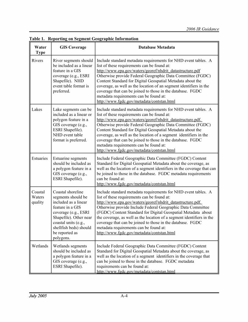
2006 IR Guidance
July 2005July 2005 A-4
Table 1. Reporting on Segment Geographic Information
WaterType
GIS Coverage Database Metadata
Rivers River segments shouldbe included as a linearfeature in a GIScoverage (e.g., ESRIShapefile). NHDevent table format ispreferred.
Include standard metadata requirements for NHD event tables. Alist of these requirements can be found at:http://www.epa.gov/waters/georef/nhdrit_datastructure.pdfOtherwise provide Federal Geographic Data Committee (FGDC)Content Standard for Digital Geospatial Metadata about thecoverage, as well as the location of an segment identifiers in thecoverage that can be joined to those in the database. FGDCmetadata requirements can be found at:http://www.fgdc.gov/metadata/contstan.html
Lakes Lake segments can beincluded as a linear orpolygon feature in aGIS coverage (e.g.,ESRI Shapefile). NHD event tableformat is preferred.
Include standard metadata requirements for NHD event tables. Alist of these requirements can be found at:http://www.epa.gov/waters/georef/nhdrit_datastructure.pdf. Otherwise provide Federal Geographic Data Committee (FGDC)Content Standard for Digital Geospatial Metadata about thecoverage, as well as the location of a segment identifiers in thecoverage that can be joined to those in the database. FGDCmetadata requirements can be found at:http://www.fgdc.gov/metadata/contstan.html
Estuaries Estuarine segmentsshould be included asa polygon feature in aGIS coverage (e.g.,ESRI Shapefile).
Include Federal Geographic Data Committee (FGDC) ContentStandard for Digital Geospatial Metadata about the coverage, aswell as the location of a segment identifiers in the coverage that canbe joined to those in the database. FGDC metadata requirementscan be found at:http://www.fgdc.gov/metadata/contstan.html
CoastalWatersquality
Coastal shorelinesegments should beincluded as a linearfeature in a GIScoverage (e.g., ESRIShapefile). Other nearcoastal units (e.g.,shellfish beds) shouldbe reported aspolygons.
Include standard metadata requirements for NHD event tables. Alist of these requirements can be found at:http://www.epa.gov/waters/georef/nhdrit_datastructure.pdf. Otherwise provide Include Federal Geographic Data Committee(FGDC) Content Standard for Digital Geospatial Metadata aboutthe coverage, as well as the location of a segment identifiers in thecoverage that can be joined to those in the database. FGDCmetadata requirements can be found at:http://www.fgdc.gov/metadata/contstan.html
Wetlands Wetlands segmentsshould be included asa polygon feature in aGIS coverage (e.g.,ESRI Shapefile).
Include Federal Geographic Data Committee (FGDC) ContentStandard for Digital Geospatial Metadata about the coverage, aswell as the location of a segment identifiers in the coverage thatcan be joined to those in the database. FGDC metadatarequirements can be found at:http://www.fgdc.gov/metadata/contstan.html

2006 IR Guidance
July 2005July 2005 A-5
4) Report attainment decisions for the segment’s standard and each of its designated use(s)
EPA encourages states and territories to provide assessment information for every segment’s designateduse(s). Each segment’s designated use should be assessed and reported to have one of the followingconditions:· Fully Supporting· Not Supporting· Insufficient or no data and information - Segments with insufficient data and information to
support an attainment determination for a standard· Not Assessed
For segments which are not attaining one or more designated uses, jurisdictions should determine andreport if the segment is expected to attain its standard (i.e., all designated uses) in the near future. Forthese segments, jurisdictions should report the other pollution control requirements which whenimplemented will result in the attainment of water quality standards. Jurisdictions should also report thedates these actions were or will be implemented and the anticipated year of attainment. This informationis need by EPA to validate the assumptions jurisdictions used when placing segments in Category 4b.
Threatened waters are those segments where a jurisdiction has determined that sufficient data exists todetermine that all designated uses are being attained, and that non-attainment is predicted by the time thenext Integrated Report is due to be submitted. These segments should be included in Category 5.
5) Document how and when the attainment decision for each segment-designated use combinationwas determined
EPA requests the following information be included to document the attainment decision for eachassessed segment designated use:
· Assessment date (e.g., December 20, 2005) - This date documents when the jurisdictioncompleted the technical analysis of data and made its decision on the segment’s designated useattainment status. A common way to store a full Y2K-compliant date is in the character formatYYYYMMDD (e.g., 20031220 for December 20, 2005).
· Assessment type - Jurisdictions should list all types of data they used to make each use attainmentdecision (e.g., physical/chemical monitoring, toxicity testing (e.g., bioassays), benthic macro-invertebrate surveys, etc.).
· Assessment confidence - Assessment confidence levels, which range from 1 (least rigorous) to 4(most rigorous) should be reported for each assessment type. Jurisdictions should providedefinitions of their assessment confidence levels in their assessment methodologies.
6) Report any pollutants and or non-pollutants causing impairment and their probable sources
Jurisdictions should report all of the pollutants or other types of pollution for impaired or threatenedsegments. The list of acceptable pollutants and other types of pollution is available onhttp://www.epa.gov/waters/adb. The list contains a complete set of chemical characteristics and non-pollutant causes of impairment. Jurisdictions should link the specific pollutant to the designated use ordesignated uses that are not being attained.

2006 IR Guidance
July 2005July 2005 A-6
Jurisdictions should also identify the probable sources contributing to an impairment. The sources shouldbe documented using the list provided on http://www.epa.gov/waters/adb. These sources need to belinked to the appropriate pollutant causing the impairment.
7) Report any observed effects of pollution for each segment-designated use combination
Jurisdictions should document and report any observed effects of pollution for each segment-designateduse combination. Observed effects may include; fish lesions, fish kills, stream bottom deposits, lowcombined biota/habitat bioassessment. How jurisdictions use observed effects to make attainmentdecisions is dependent upon a jurisdictions’ interpretation of their water quality standards and should bedocumented in their assessment methodology.
8) Report on approved TMDLs and provide a schedule for establishing TMDLs
Jurisdictions must submit an estimated schedule for establishing TMDLs for every pollutant on eachsegment in Category 5. This schedule should specify the year for all TMDLs which will be establishedprior to the next Integrated Report, and the number per year for all others. In addition jurisdictions shouldindicate which of the pollutants on impaired segments have an approved TMDL. Jurisdictions shouldindicate the date EPA approved these TMDLs and the EPA TMDL identification number. Information onthe approval date and EPA TMDL identification number can be found on http://www.epa.gov/waters/tmdl.
B. Reporting assessments based on State-wide or watershed-level probability designs
The following sections address the data requirements recommended by EPA for reporting probability-based assessments. This guidance defines the data elements and format necessary to document ajurisdiction’s assessment based upon probability based monitoring designs. Each data element is definedin Table 3.
1) Identify the waters assessed through a probability design ("target population")
Study area findings should be associated with the area’s standard(s) and should be clearly documentedalong with the target population that was monitored to develop the indicator. For instance, wadeableperennial streams throughout a state and territory may be the target population for an indicator ofbiological integrity related to aquatic life support. Each probability survey project should be assigned anID (a Probability Survey Project ID).
2) Report the geographic locations of the target populations using NHD
Where the target population is not the same as an entire state, maps should be provided that use polygonsto highlight a project’s geographic area such as all waters of a specific class (e.g., lakes) throughoutwatershed units, eco-regions, or other geographic regions. States and territories are expected to have GISpolygon coverages (e.g., ESRI Shapefile) related to each probability survey project. GIS coveragesshould conform to Federal Geographic Data Committee (FGDC) Content Standard for Digital GeospatialMetadata. State in-house probability survey project polygons should be available with basic FGDC

2006 IR Guidance
July 2005July 2005 A-7
compliant metadata in either a shapefile format or in a standard ESRI export file format (*.e00). Additional information can be found at: http://www.fgdc.gov/metadata/contstan.html.Additional information to define the geographic frame (sample frame or “population”) for a probabilitysurvey project should include such items as: the water type relevant to the project (e.g., rivers); or other“stratification” features.
States and territories are also expected to develop size estimates for the entire target population. Statesand territories should be able to document the GIS Hydrography coverage or other data layer used todevelop their target population sizes.
3) Report attainment results for water quality standards
For each probability survey project, attainment results should be summarized. The presentation of thestudy’s findings should apply a breakpoint that clearly defines the estimated percentage of the total targetpopulation meeting standards and the percentage not meeting standards. For each probability surveyproject, a description of the project methodology should be provided. Where there are a small number ofstandard project designs, a state can make reference to pertinent sections from its monitoring strategy,QAPP and/or assessment methodology materials. The estimated percentage of the target populationmeeting standards should also be accompanied by the precision of the estimate, in the form of 90 or 95%confidence intervals.
4) Report the precision and date of the probable attainment results
A major attraction of probability designs is that statistics can be developed that show the confidencelevels associated with attainment results. States and territories should provide a discussion of thestatistical tests they apply to produce the precision value information or refer to other documents thatprovide this information such as a QAPP or assessment methodology. As with reporting for segmentresults, the assessment date should be included for each probability survey project indicating when thestate and territory finished the technical analysis of data and made its decision on the standards attainmentstatus.
5) Report any pollutants and non-pollutants and their probable sources
Where possible, EPA requests that states and territories develop pollutant and source summaryinformation for each of their probability survey projects. The maximum impact percentage should notexceed the percent for the use non-attainment results reported.

2006 IR Guidance
July 2005July 2005 A-8
C. Data elements to be reported using EPA’s Assessment Database or an equivalent relationaldatabase
Data elements to be reported using either EPA’s Assessment Database or the relational database structureoutlined in Section D, Minimal Database Elements to Support Electronic Submission.
Table 2. Segment Specific Data Elements to be reported in the 2006 Integrated ReportField Name Field
TypeDomain Description Requirement
Condition
STATE Text http://www.epa.gov/waters/adb/
State or jurisdictionabbreviations
AlwaysRequired
TOT_WATER_TYPE Text http://www.epa.gov/waters/adb/
Water type for theAtlas of Total waterswithin a jurisdiction
AlwaysRequired
TOT_WATER_SIZE Numeric Dependentupon units usedto measure
Water size for theAtlas of Total waterswithin a jurisdiction
AlwaysRequired
SCALE Text Free Text Scale (i.e. 1:24,000)of the source used todetermine the watersize for the Atlas oftotal waters within ajurisdiction
AlwaysRequired
TOT_SOURCE Text Free Text Source used todetermine the watersize for the Atlas oftotal waters within ajurisdiction
AlwaysRequired
ID305B Text Free text,Jurisdictionspecific
Unique identifier forAssessment Unit ID(state defined)
AlwaysRequired
CYCLE Date YYYY Reporting Cycle AlwaysRequired
WATER_NAME Text Free Text Name of AssessmentUnit
AlwaysRequired
LOCATION Text Free Text,Jurisdictionspecific *Note,this does notreplace linkingAssessmentUnits to theNHD
Text description ofthe AssessmentUnit’s location
AlwaysRequired

2006 IR Guidance
Field Name FieldType
Domain Description RequirementCondition
July 2005July 2005 A-9
WATER_TYPE Text http://www.epa.gov/waters/adb/
Water type for theAssessment Unit(e.g., River, Estuary,Wetland)
AlwaysRequired
WATER_SIZE Numeric Dependentupon units usedto measure
Size of theAssessment Unit
AlwaysRequired
SIZE_UNIT Text http://www.epa.gov/waters/adb/
Size unit (e.g. Milesif WATER_TYPE isRiver)
AlwaysRequired
TROPHIC_STATUS Text http://www.epa.gov/waters/adb/
Trophic status ofpublicly owned lakes
Optional
TREND Text http://www.epa.gov/waters/adb/
Trend of publiclyowned lakes
Optional
CYCLE_LAST_ASSESSED Date YYYY The most recentcycle that anAssessment Unit wasassessed
Optional
MONITORING_SCHEDULED_DATE
Date YYYY Date by whichadditional monitoringfor attainment statuswill be completed
Optional
PREVIOUSID305B Text Free Text Used for trackingAssessment Unitsfrom cycle to cycle. This field would beused when there is achange in the IDstructure for anAssessment Unit, orif an AssessmentUnit gets split
ConditionallyRequired: If anAssessment unithas changedfrom thepreviousreporting cycle,then a recordneeds to bemaintained ofhow the new IDmatches with theprevious ID

2006 IR Guidance
Field Name FieldType
Domain Description RequirementCondition
July 2005July 2005 A-10
PREVIOUSCYCLE Date YYYY Cycle for theprevious AssessmentUnit ID. Used forcycle tracking
ConditionallyRequired: IfPREVIOUSID305B ispopulated, thenthe cycle that theprevious ID isassociated withshould also bepopulated.
USE_NAME Text http://www.epa.gov/waterscience/wqs
Description of thedesignated use whichis being assessed
AlwaysRequired
ATTAINMENT Text FullySupporting, NotSupporting,InsufficientInformation orNot Assessed
The attainment statusfor a particulardesignated useassociated with anAssessment Unit
AlwaysRequired
THREATENED_FLAG Text Y/null Flag used to indicatethreatened waters. Threatenedassessment units arethose assessmentunits where uses arebeing attained, butnon-attainment ispredicted by the timethe next IntegratedReport is submitted.
ConditionallyRequired: Mustbe populated ifthe use isThreatened
ASSMNT_TYPE Numeric http://www.epa.gov/waters/adb/
Caption describing acategory of datatypes used to makeattainment/impairment decision
ConditionallyRequired: Mustbe populated forall uses that areassessed
ASSMNT_CONF Numeric http://www.epa.gov/waters/adb/
A score ranging froma lower range of 1 upto 4 indicatingreliability andprecision for acategory of standardspecific assessmenttype
Optional
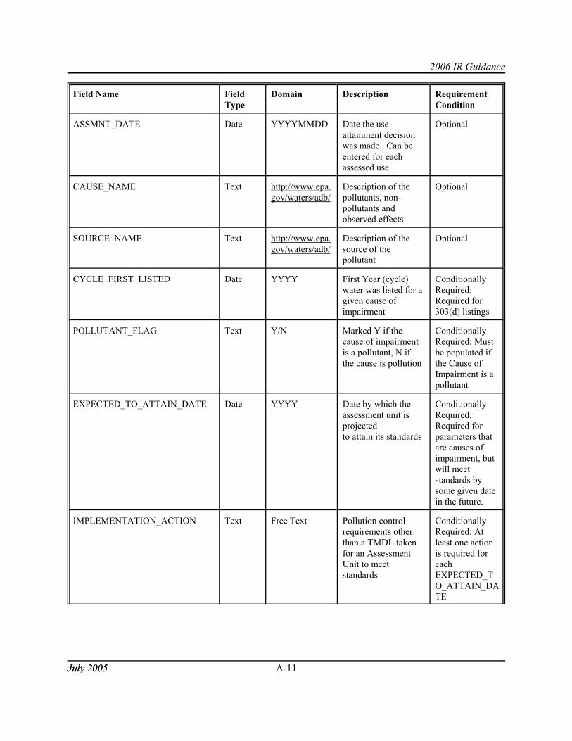
2006 IR Guidance
Field Name FieldType
Domain Description RequirementCondition
July 2005July 2005 A-11
ASSMNT_DATE Date YYYYMMDD Date the useattainment decisionwas made. Can beentered for eachassessed use.
Optional
CAUSE_NAME Text http://www.epa.gov/waters/adb/
Description of thepollutants, non-pollutants andobserved effects
Optional
SOURCE_NAME Text http://www.epa.gov/waters/adb/
Description of thesource of thepollutant
Optional
CYCLE_FIRST_LISTED Date YYYY First Year (cycle)water was listed for agiven cause ofimpairment
ConditionallyRequired:Required for303(d) listings
POLLUTANT_FLAG Text Y/N Marked Y if thecause of impairmentis a pollutant, N ifthe cause is pollution
ConditionallyRequired: Mustbe populated ifthe Cause ofImpairment is apollutant
EXPECTED_TO_ATTAIN_DATE Date YYYY Date by which theassessment unit isprojectedto attain its standards
ConditionallyRequired:Required forparameters thatare causes ofimpairment, butwill meetstandards bysome given datein the future.
IMPLEMENTATION_ACTION Text Free Text Pollution controlrequirements otherthan a TMDL takenfor an AssessmentUnit to meetstandards
ConditionallyRequired: Atleast one actionis required foreachEXPECTED_TO_ATTAIN_DATE

2006 IR Guidance
Field Name FieldType
Domain Description RequirementCondition
July 2005July 2005 A-12
ACTION_DATE Date YYYYMMDD Date other pollutioncontrol requirementwas/will becompleted
ConditionallyRequired:Required foreachIMPLEMENTATION_ACTION
TMDL_SCHEDULE Date YYYY Date when thejurisdictionanticipatessubmitting theTMDL for EPAapproval
ConditionallyRequired: EitherTMDL_SCHEDULE orTMDL_PRIORITY must bepopulated forcauses that arepart of the303(d) list.
TMDL_PRIORITY Text High, Medium,Low
State’s priority fordeveloping a TMDL
ConditionallyRequired: EitherTMDL_SCHEDULE orTMDL_PRIORITY must bepopulated forcauses that arepart of the303(d) list.
TMDL_COMPLETION_DATE Date YYYYMMDD Date TMDL wascompleted or the dateby which a TMDL isprojected to becompleted
Optional
TMDL_ID Numeric http://www.epa.gov/waters/tmdl
EPA assigned uniqueidentifier forapproved TMDLs
ConditionallyRequired: Mustbe populated forcauses that havehad TMDLsestablished
TMDL_PROJECT_STATUS Text http://www.epa.gov/waters/adb/
Brief descriptionregarding the statusof the TMDLdevelopment for agiven AssessmentUnit/Pollutantcombination.
Optional

2006 IR Guidance
Field Name FieldType
Domain Description RequirementCondition
July 2005July 2005 A-13
TMDL_STATUS_COMMENT Text Free Text Summary commentdescribing the statusof the TMDLdevelopment for agiven AssessmentUnit/Pollutantcombination.
Optional
DELISTING_REASON Text http://www.epa.gov/waters/adb/
Reason anAssessmentUnit/Cause has beenremoved from the303(d) list
ConditionallyRequired: Mustbe populated forAssessmentUnits/Causesthat have beenremoved fromthe 303(d) list
DELISTING_COMMENT Text Free Text Summary commentdescribing thereasons for delisting
Optional
DELISTING_DATE Date YYYYMMDD Date an AssessmentUnit/Cause has beenremoved from the303(d) list
ConditionallyRequired: Mustbe populated forAssessmentUnits/Causesthat have beenremoved fromthe 303(d) list
MONITORING_STRATEGY BLOB Free Text The jurisdiction’scurrent monitoringstrategy documentstored in PDF, MSWord or WordPerfectformat.
Optional
ASSESSMENT_METHODOLOGY BLOB Free Text A copy of theassessmentmethodology used tomake attainmentdecisions stored inPDF, MS Word orWordPerfect format.
Optional

2006 IR Guidance
July 2005July 2005 A-14
Table 3. Probabilistic Monitoring Data Elements to be reported in the 2006 Integrated Report
Field Name FieldType
Domain Description RequirementCondition
PROJECT_ID Text Free textjurisdictionspecific
State assigned identifierused to uniquely identifythe study/project
AlwaysRequired
CYCLE Date YYYY Reporting Cycle AlwaysRequired
PROJECT_NAME Text Free Text Name of the project AlwaysRequired
TARGET_POPULATION Text Free Textjurisdictionspecific
Description of theproject’s targetpopulation
AlwaysRequired
WATER_TYPE Text http://www.epa.gov/waters/adb/
Water type for theassessment unit (e.g.,River, Estuary, Wetland)
AlwaysRequired
WATER_SIZE Numeric Dependentupon unitsused tomeasure
Size represented by thetarget population
ConditionallyRequired:Required ifWATER_TYPE is populated
SIZE_UNIT Text http://www.epa.gov/waters/adb/
Size unit (e.g. Miles ifWATER_TYPE isRiver)
ConditionallyRequired:Required ifWATER_SIZE is populated
LOCATION_TYPE Text Free Text Description of the typeof location (i.e. 8-digitHUC, County, etc.)
Optional
LOCATION_DESC Text Free Text Values for locationsassociated with anAssessment Unit orProject ID.
ConditionallyRequired:Required ifLOCATION_TYPE ispopulated
INDICATOR Text Free Text A description of theindicator that wasmonitored (e.g.Biological indicator,Trophic State Index,etc.)
AlwaysRequired
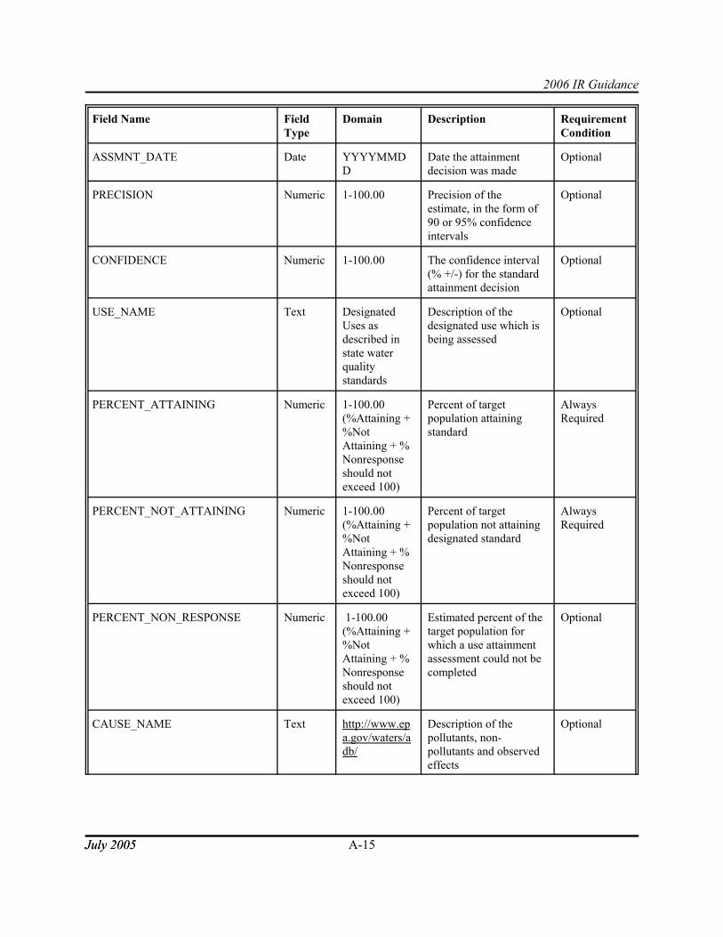
2006 IR Guidance
Field Name FieldType
Domain Description RequirementCondition
July 2005July 2005 A-15
ASSMNT_DATE Date YYYYMMDD
Date the attainmentdecision was made
Optional
PRECISION Numeric 1-100.00 Precision of theestimate, in the form of90 or 95% confidenceintervals
Optional
CONFIDENCE Numeric 1-100.00 The confidence interval(% +/-) for the standardattainment decision
Optional
USE_NAME Text DesignatedUses asdescribed instate waterqualitystandards
Description of thedesignated use which isbeing assessed
Optional
PERCENT_ATTAINING Numeric 1-100.00(%Attaining +%NotAttaining + %Nonresponseshould notexceed 100)
Percent of targetpopulation attainingstandard
AlwaysRequired
PERCENT_NOT_ATTAINING Numeric 1-100.00(%Attaining +%NotAttaining + %Nonresponseshould notexceed 100)
Percent of targetpopulation not attainingdesignated standard
AlwaysRequired
PERCENT_NON_RESPONSE Numeric 1-100.00(%Attaining +%NotAttaining + %Nonresponseshould notexceed 100)
Estimated percent of thetarget population forwhich a use attainmentassessment could not becompleted
Optional
CAUSE_NAME Text http://www.epa.gov/waters/adb/
Description of thepollutants, non-pollutants and observedeffects
Optional

2006 IR Guidance
Field Name FieldType
Domain Description RequirementCondition
July 2005July 2005 A-16
CAUSE_PERCENT Numeric Sum of allimpairmentpercentagesnot to exceedthe percent notattaining
Percent of non-attainingpopulation impaired by aspecific cause (30%non-attainmentattributed to nitrogen)
Optional
SOURCE_NAME Text http://www.epa.gov/waters/adb/
Description of thesource of the pollutant
Optional
SOURCE_PERCENT Numeric Sum of allsourcepercentagesnot to exceed100% for agivenimpairment
Percent of non-attainingpopulation attributableto a particular source ofpollution (e.g. of the30% of nitrogenimpaired waters, 70%was potentiallyattributable toagricultural runoff)
Optional
MONITORING_STRATEGY BLOB Free Text The jurisdiction’scurrent monitoringstrategy document storedin PDF, MS Word orWordPerfect format.
Optional
ASSESSMENT_METHODOLOGY BLOB Free Text A copy of theassessment methodologyused to make attainmentdecisions stored in PDF,MS Word orWordPerfect format.
Optional
D. Minimal Database Design to support electronic submission of the Integrated Report
The data elements and business processes outlined in the previous three sections must be assembled into arelational database design. EPA’s Assessment Database is one data base design capable of storing andreporting the attainment status of a jurisdiction’s waters. States and territories should use EPA’sAssessment Database to track the attainment status of their segments and to submit the supportinginformation behind their Integrated Report. If a state or territory or authorized tribe chooses not to use theAssessment Database, then at a minimum they should use the database design outlined in Diagram A totransmit their Integrated Report to EPA. EPA will provide any interested state or territory training andsupport using the Assessment Database.

A-17
Diagram A. Entity relationship diagram for the minimum elements needed to support anelectronic submission of the Integrated Report.