guanabara bay operational monitoring and … bay operational monitoring and forecasting system. ......
TRANSCRIPT
Delft-FEWS coastal application to the Rio de Janeiro region, Southeast Brazil
Upon request of the Hydrography Center of the Brazilian Navy in Rio de Janeiro, Deltares set up
a real-time coastal forecasting system for Guanabara Bay, one of the busiest estuaries in South
America in both shipping and recreational activities.
This system, named FEWS-Guanabara, processes available measurement data (from Navy and from INMET), meteorological forecasts (from INPE, REMO and NOAA) and oceanographic forecasts (from REMO) to generate local hydrodynamics and waves forecasts, using dedicated local area models. FEWS-Guanabara also users the processed measurement data for systematic model validation. With the local forecasts generated by FEWS-Guanabara, alerts are issued when forecast water levels drop below a minimum value, required for vessel keel clearance. Also, the system issues alerts when waves are too large, or when cross-track currents along the main shipping lanes are too strong, in view of port operation. Using this information, the Brazilian Navy generates reports both for internal use and for public dissemination (port authorities, beach lifeguards, coastal airport, etc).
The main software packages used to setup FEWS-Guanabara are the (open source) Delft3D modelling suite and the (license-free) Delft-FEWS open shell forecasting system.
The study comprises the period 2011-2013.
Guanabara Bay Operational Monitoring and Forecasting System
BackgroundGuanabara Bay is one of the busiest estuaries in the world. Located in southeast Brazil and bordered by two big cities, Rio de Janeiro and Niterói, the bay is famous both for its natural beauty and for its dense shipping traffic. Rio de Janeiro has recently become a UNESCO World Heritage site, also due to its coastal features – it is a unique city squeezed between the hills (“Serra do Mar ”), the southern Atlantic Ocean and Guanabara Bay. Among many major international events, Rio de Janeiro hosted the Rio+20 conference in 2012, will host the FIFA World Cup 2014 and the Olympic Games in 2016. The bay is also the stage for popular beaches and other touristy spots along its edge, it is crossed by dozens of commuter ferries every day, and its islands also contain important infrastructure
(one international airport, one national airport, one Federal University, one large Research Center, major LNG terminals). Local authorities have to deal with (and issue alerts to) heavy container traffic from the Port of Rio, to ships from two large Navy bases, to a fleet of local ferries and catamarans, and to many recreational boats. Rio de Janeiro has also become a major oil and gas hub in South America, and overall shipping in Guanabara Bay has increased 150% during 2009-2011.
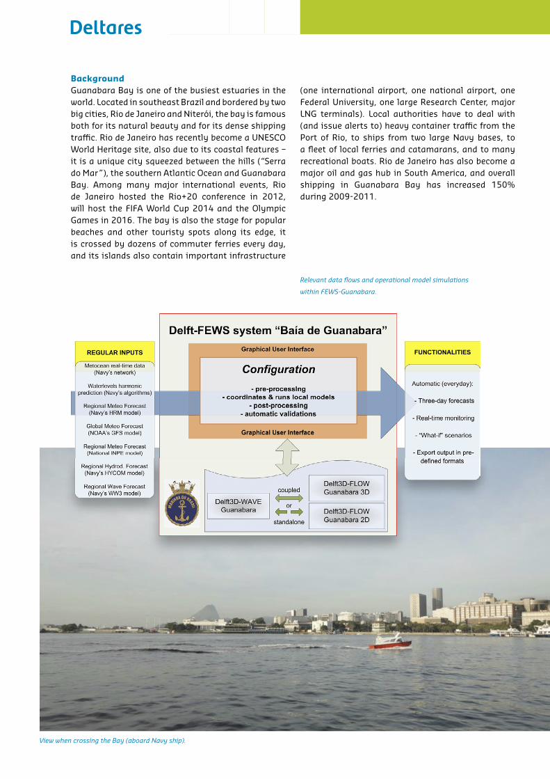
Relevant data flows and operational model simulations
within FEWS-Guanabara.
View when crossing the Bay (aboard Navy ship).
FEWS-Guanabara - real-time coastal monitoring and forecasting systemDeltares was approached by the Hydrography Center of the Brazilian Navy (“Centro de Hidrografia da Marinha”) to set up a real-time coastal monitoring and forecasting system for Guanabara Bay. This system is based on two software packages developed and distributed by Deltares, the (open source) Delft3D modeling suite and the (license-free) Delft-FEWS open shell forecasting system (http://oss.deltares.nl).
FEWS-Guanabara automatically imports and processes larger-scale meteorological and oceanographic model results to force local Delft3D models of Guanabara. These hydrodynamics and waves forecasts are generated automatically every 12 hours from the system. Results are validated against field data, operationally.
Large-scale meteorological and oceanographic forecasts are obtained from REMO (a Brazilian oceanographic consortium formed between the Navy, Petrobras and four major Universities) and are used to force local Delft3D-FLOW and Delft3D-WAVE models for Guanabara Bay. The local models were developed together with Applied Science Associates Latin America (in São Paulo). Operated within FEWS, the Delft3D-FLOW yields fully baroclinic three-dimensional hydrodynamic fields as well as two-dimensional depth-averaged hydrodynamics (the latter model generates results faster, which is preferable in an operational context).
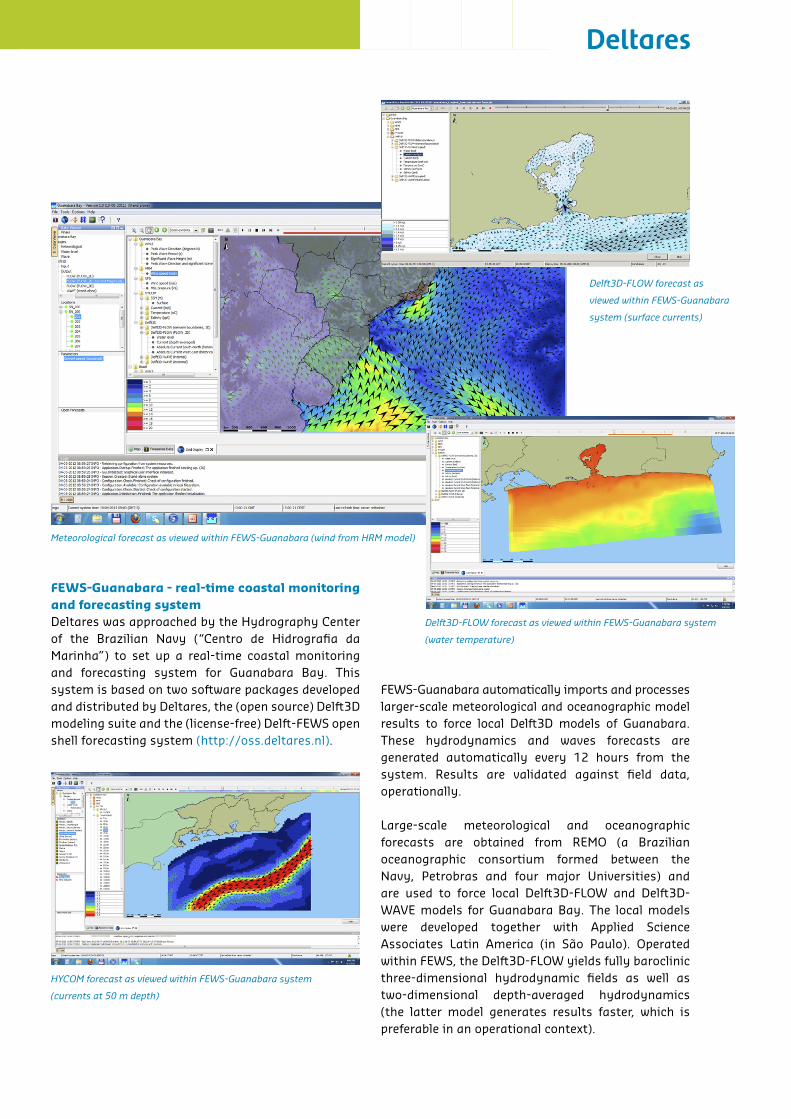
Delft3D-FLOW forecast as
viewed within FEWS-Guanabara
system (surface currents)
Meteorological forecast as viewed within FEWS-Guanabara (wind from HRM model)
HYCOM forecast as viewed within FEWS-Guanabara system
(currents at 50 m depth)
Delft3D-FLOW forecast as viewed within FEWS-Guanabara system
(water temperature)
Propagation from deeper ocean waves and wind-generation of short-crested waves is simulated using Delft3D-WAVE, based on the SWAN wave model. Meteorological forecasts from INPE (Brazil’s Instituto Nacional de Pesquisas Espaciais) and from NOAA (USA’s National Oceanic and Atmospheric Administration) are also included in the system, for redundancy. The use of field data from Navy’s hydrologic sensors and from INMET’s weather stations is a key aspect of the present system to systematically evaluate model performance. Within the scope of this project, the Navy staff was trained in usage of both Delft3D and Delft-FEWS.
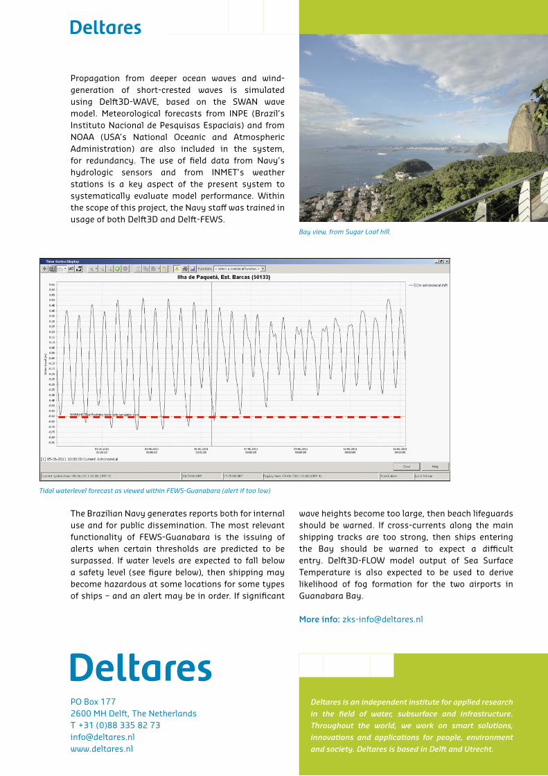
The Brazilian Navy generates reports both for internal use and for public dissemination. The most relevant functionality of FEWS-Guanabara is the issuing of alerts when certain thresholds are predicted to be surpassed. If water levels are expected to fall below a safety level (see figure below), then shipping may become hazardous at some locations for some types of ships – and an alert may be in order. If significant
wave heights become too large, then beach lifeguards should be warned. If cross-currents along the main shipping tracks are too strong, then ships entering the Bay should be warned to expect a difficult entry. Delft3D-FLOW model output of Sea Surface Temperature is also expected to be used to derive likelihood of fog formation for the two airports in Guanabara Bay.
More info: [email protected]
Tidal waterlevel forecast as viewed within FEWS-Guanabara (alert if too low)
Bay view, from Sugar Loaf hill.
Deltares is an independent institute for applied research
in the field of water, subsurface and infrastructure.
Throughout the world, we work on smart solutions,
innovations and applications for people, environment
and society. Deltares is based in Delft and Utrecht.
PO Box 1772600 MH Delft, The NetherlandsT +31 (0)88 335 82 [email protected]