gscb workshop 2012 eumetsat missions - earth.esa.int · gscb workshop 2012 eumetsat missions...
TRANSCRIPT

Slide: 1
GSCB Workshop 2012 EUMETSAT Missions
EUMETSAT GSCB Workshop 2012
ESRIN, Frascati 6-7 June 2012

Slide: 2
Introduction To EUMETSAT
The European Organisation for the Exploitation of Meteorological Satellites, EUMETSAT, is an intergovernmental organisation, established in 1986 and is headquartered in Darmstadt, Germany.
EUMETSAT is funded by the National Meteorological Services of its Member States to deliver operational satellite data and products that satisfy the meteorological and climate data requirements of the Member States – 24 hours a day, 365 days a year, through decades. This is carried out taking into account the recommendations of the World Meteorological Organization (WMO).
EUMETSAT’s primary objective is “to establish, maintain and exploit European systems of operational meteorological satellites.”
A further objective is “to contribute to the operational monitoring of the climate and the detection of global climatic changes.”

Slide: 3
EUMETSAT Missions
EUMETSAT operates and processes and disseminates data from: First generation Meteosat geostationary satellites (Meteosat-7), Second generation Meteosat geostationary satellites (Meteosat-8, 9), Polar-orbiting Metop satellites (Metop-A). Ocean Surface Topography Mission (Jason-2).
EUMETSAT also routinely acquires, processes and disseminates data from:
NOAA polar-orbiting satellites (NOAA-19).

Slide: 4
EUMETSAT space segment
00 01 02 03 04 05 06 07 08 09 10 11 12 13 14 15 16 17 18 19 20 21 22 23 24 25 26 27 28 29 30 31 32 33 34 35 36 37 38 39 40 YEAR...
METEOSAT FIRST GENERATION METEOSAT-6 METEOSAT-7
METEOSAT SECOND GENERATION METEOSAT-8
METEOSAT-9 METEOSAT-10
METEOSAT-11
METEOSAT THIRD GENERATION
MTG-l-1 MTG-S-1
MTG-l-2
MTG-l-3 MTG-S-2
MTG-l-4
EUMETSAT POLAR SYSTEM (EPS) METOP-A
METOP-B
METOP-C EPS SECOND GENERATION
OCEAN SURFACE TOPOGRAPHY MISSION
JASON-2
JASON-3 JASON CONTINUITY OF SERVICES (CS)
THIRD-PARTY PROGRAMMES GMES SENTINEL-3
GMES SENTINEL-4 ON MTG
GMES SENTINEL-5 ON EPS SECOND GENERATION

Slide: 5
EUMETSAT ground segment overview
Users!

Slide: 6
Distributed Applications Ground Segment
!
4!
7!
6!
2!
1!5! 8!
3!
Member State Cooperating State Support to Nowcasting and Very Short Range Forecasting Ocean and Sea Ice Climate Monitoring Numerical Weather Prediction Land Surface Analysis Ozone and Atmospheric Chemistry Monitoring GRAS Meteorology Support to Operational Hydrology and Water Management SAF Consortium Member Additional Met Service Users
6!
7!
8!
5!
4!
3!
2!
1!

Slide: 7
For daily weather forecasting, to save human life and
property…!
For industry, aviation, maritime transport …!
… and for climate and environmental monitoring.!
Data applications
To assist the human forecaster in diagnosing and monitoring
the development of hazardous weather systems…!

Slide: 8
EUMETSAT Data Access Principle
• EUMETSAT aims to promote the availability and use of near real-time and archived data for wider global user community
• This is achieved through the provision of: • an online catalogue using interoperable standards • a single entry point for service registration • freely available web imagery for quick looks and the lay user audience • delivery mechanisms using commercially available reception station
equipment, and • the use of agreed standard data formats (WMO standards & community-
specific de-facto standards)
• Use of international standards in data discovery and access allows for easier data exchange with other satellite operators and data providers

Slide: 9
Earth Observation Portal (EOP)
• Provides EUMETSAT users with a single point of online access to all EUMETSAT data and dissemination services.
• This allows users to discover, search, order and subscribe to operational services: • Product Navigator – since Nov 2008 • EOP User Management – single sign-on registration service – Jan 2010
• Uses internationally recognised standards (ISO & OGC) and complying with the INSPIRE EU directive
• Main component is the EOP Clearinghouse which provides OGC, INSPIRE and EUMETSAT interfaces and enables communication with legacy systems and external partners.
EOP Usage: over 6000 registered EOP Users; over 300 unique users of the Product Navigator & User Management components are recorded per day.

Slide: 10
EO Portal: supported standards
Supported OGC/ESA/HMA, WMO, INSPIRE Standards: – OGC 07-006r1, OpenGIS Catalogue Service 2.0.2, supporting the Dublin Core based information model – OGC 07-045, OpenGIS Catalogue Service 2.0.2 – ISO Metadata Application Profile 1.0 – OGC 07-038r3, OGC Cataloguing of ISO Metadata (CIM) using the ebRIM profile of CS-W – OGC 08-197: INSPIRE Conformance Class of OGC Cataloguing of ISO Metadata (CIM) using the ebRIM profile of CS-W
- CIM EP Protocol Binding of INSPIRE Discovery Services – OGC 06-131, EO Products Extension Package for ebRIM Profile of CSW 2.0 – OGC 06-080, GML Application Schema for EO Products – OGC 06-141, Ordering Services for Earth Observation Products – OGC 03-109r1, OGC Web Map Service 1.3.0 – OGC 07-063r1 OpenGIS WMS EO Application Profile (partial) – OGC 07-118r8, OGC/HMA User Management Interfaces for Earth Observation Services, Version 1.0 – INSPIRE Metadata Implementing Rules: Technical Guidelines based on EN ISO 19115 and EN ISO 19119, European
Commission Joint Research Centre, 16-06-2010 – INSPIRE DS: Technical Guidance for the implementation of INSPIRE Discovery Services, Drafting Team Network
Services, 18-03-2011 – WMO/WIS z39.50/SRU ISO19115 : Working draft specified by WMO/WIS – EO Portal SOAP WS-S – SAML 2.0 ECP Profile with SOAP Binding – SAML 2.0 Web Browser SSO Profile with HTTP Redirect/Post Binding

Slide: 11
Earth Observation Portal – Collections Catalogue
Key Features:!!
Product Navigator provides metadata
descriptions, data provider and data access
information.!!
Includes all EUMETSAT products and third-party products on EUMETCast.!
!Uses open standards (e.g.
OGC, Inspire) for catalogue interoperability with other organisations.!
!Version 2.0!
Released in Aug 2011!
!!!http://navigator.eumetsat.int!

Slide: 12
Earth Observation Portal & GEOSS
Integration with GCI!(GEOSS Common Infrastructure) :!
!Product Navigator is a
registered GEOSS Resource!
!Contents are routinely harvested by the GEO
Web Portal!!
EUMETSAT & GEONETCast partner data can be discovered via the
GEO Web Portal!(publication of
EUMETSAT EO-Portal in the GEOSS Registry) !
!!!!!
http://navigator.eumetsat.int!

Slide: 13
Earth Observation Portal & GEOSS
Integration with GEONETCast:!
!Product Navigator provides metadata descriptions of all
GEONETCast delivered data.!!
Disseminated via EUMETCast for use on local reception stations!
!Offline version allows for data discovery in Internet
poor regions!!!!!!!
Slide: 14
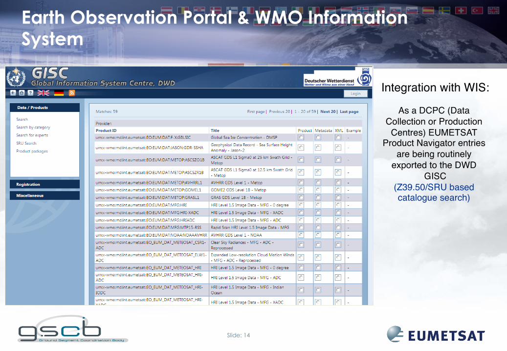
Earth Observation Portal & WMO Information System
Integration with WIS:!!
As a DCPC (Data Collection or Production
Centres) EUMETSAT Product Navigator entries
are being routinely exported to the DWD
GISC!(Z39.50/SRU based catalogue search) !
!!!!!!!!

Slide: 15
EO Portal – HMA service status (1)
• Collection & Service Discovery OGC 07-038r3, OGC Cataloguing of ISO Metadata (CIM) using ebRIM profile of
CS-W, Version 0.1.12 & OGC 08-197: INSPIRE Conformance Class of OGC Cataloguing of ISO Metadata
(CIM) using the ebRIM profile of CS-W – CIM EP Protocol Binding of INSPIRE Discovery Services
• Earth Observation Product Metadata OGC 06-080, GML Application Schema for EO Products, Version 0.9.3, 21/07/2008
• Catalogue Search OGC 06-131r6, EO Products Extension Package for ebRIM Profile of CSW 2.0.2,
Version 0.2.4

Slide: 16
EO Portal – HMA service status (2)
• Order OGC 06-141. Ordering Services for Earth Observation Products, Version
0.9.4, 05/09/2008 • Identity Management (based on OpenAM)
OGC 07-118r8, OGC/HMA User Management Interfaces for Earth Observation Services, Version 1.0
• Web Map Service (not planned yet)
OGC 07-063r1 OpenGIS WMS EO Application Profile, 31/10/2008 • Feasibility Analysis (no implementation foreseen by EUMETSAT)
OGC 07-018, Opengis Sensor Planning Service Application Profile for EO Sensors, version 0.9.5, 19/11/2007

Slide: 17
Earth Observation Portal – User Registration
Key Features:!!
Single sign-on provides access to all EUMETSAT Data and Products (NRT &
archived data)!!
Provides quick and easy data licensing !
!Further enhancements will
allow subscriptions to service announcements/
messages!!
Federated user management for
interoperability with partner organisations!

Slide: 18
Web Imagery - Web Map Service
Key Features:!!
Provides a simple view of EUMETSATʼs data and product suite!
• NRT imagery!• RGB Composites!
• Visualised Products!
WMS imagery available in GEOTIFF for use in GIS interfaces !
!Allows easy regional selection; overlay of
products; choice of background!!
WMS images are discovered through the EOP - Product Navigator!
!OGC standards allow for easy exchange of
imagery between WMS providers!!
Pilot WMS Service in 2012 (delays due to Cinesat Releases).!
Slide: 19
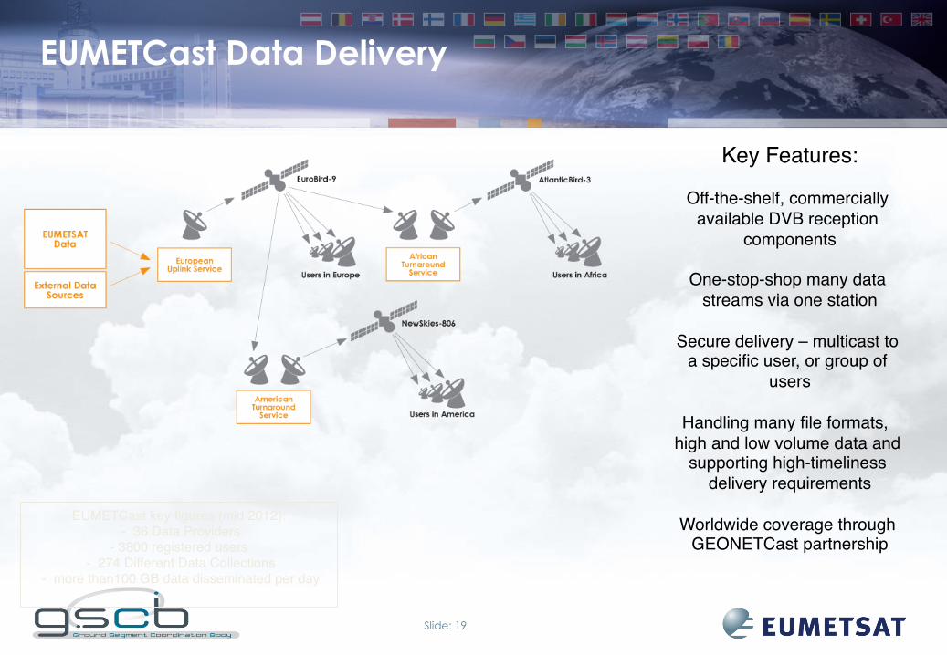
EUMETCast Data Delivery
Key Features:!!
Off-the-shelf, commercially available DVB reception
components!!
One-stop-shop many data streams via one station!
!Secure delivery – multicast to
a specific user, or group of users!!
Handling many file formats, high and low volume data and
supporting high-timeliness delivery requirements!
!Worldwide coverage through
GEONETCast partnership!EUMETCast key figures (mid 2012):!
- 36 Data Providers!- 3800 registered users!
- 274 Different Data Collections! - more than100 GB data disseminated per day!
!

Slide: 20
GEONETCast Availability of Data
Slide: 21
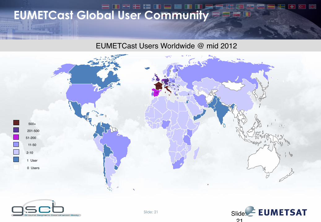
EUMETCast Users Worldwide @ mid 2012!
Slide: 21!
EUMETCast Global User Community
!!
12!
4!!!!!
!!!!
419!
41!
!!
13!
! 310!
!
745!
!!!!! ! !
!115!
!!!
6!
34!
119!36!
!
1!!!
11!
! 17!
16!
2!
!!
10!! 4! 4!
3!
21!
26!
!
676!
! 30!
2!
2!
39!
! 6!
14!
8!
2-10!
11-50!
51-200!
201-500!
1 User!
500+!
0 Users!

Slide: 22
Offline data access via EUMETSAT Unified Meteorological Archive/Retrieval Facility (UMARF)
EPS facilities
EUMETSAT Geostationary Systems Meteosat satellites
EUMETSAT Polar System Metop satellites
USERS
Jason-2 Optional Programme for Ocean Altimetry
SATELLITE APPLICATION FACILITIES
within the Member States
MSG facilities MTP facilities Jason-2 facilities
Level 0 +Level 1 + Level 2 à Data Archiving!!
records back to 1981!!
ß Data Retrieval !FTP
EO Portal!
HTTP
Media delivery

Slide: 23
EUMETSAT Data Centre Growth Trends
Prognosis
Current archive Storage capacity
1.0
10.0
100.0
1,000.0
10,000.0
100,000.0
Vo
lum
e in
Ter
abyt
e
EUMETSAT Data Centre - data flows
total Archive volume
yearly ingestion
yearly retrieval
Storage capacity With T10K-C 17.5 PB

Slide: 24
Content of Data Archive
• For all instruments the following data is stored (near-line) in the Data Centre:
Level 0 + auxilliary files Level 1 + auxilliary files Level 2 (in case of SAF’s, only metadata)
• Ancillary Data are stored in a dedicated environment outside the Archive • Documentation (e.g. Mission architecture, data/ products description, validation reports) is stored and archived in Document Management System
• Reports (CAL/VAL) are stored in a dedicated environment outside the Archive

Slide: 25 25!
LTDP European Framework contribution and participation
• EUMETSAT’s LTDP policy is to a very large extent coherent with the European LTDP Common Guidelines • As an operational entity EUMETSAT has an established user community and is guided by the recommendations of the users and the WMO • EUMETSAT supported the review of the LTDP documents and provided feedback/ input • EUMETSAT is interested in staying involved with the European LTDP and continuing the support provided to the LTDP, e.g. in the GSCB context

Slide: 26
Links
EUMETSAT: http://www.eumetsat.int
Helpdesk: [email protected] Data and Products: http://www.eumetsat.int/Home/Main/DataProducts/
EO Portal: http://eoportal.eumetsat.int/
Product Navigator: http://navigator.eumetsat.int/ EUMETCast: http://www.eumetsat.int/Home/Main/DataAccess/EUMETCast
Data Centre: http://www.eumetsat.int/Home/Main/DataAccess/EUMETSATDataCentre