groundwater, water management and hydraulic fracturing
DESCRIPTION
ÂTRANSCRIPT

T8TA - WHAT’S THE DRILL ON GAS? - MARCH 2015
GROUNDWATER, WATER MANAGEMENT AND HYDRAULIC FRACTURING
Wednesday, April 1, 15

OUTLINE
Hydraulic fracturing - what are the risks?
What do we know about location-specific risks?
What we don’t know
What we should know
Wednesday, April 1, 15

WHAT IS HYDRAULIC FRACTURING (FRACKING)?
Wednesday, April 1, 15

The shale bed needs to be shattered nearly everywhere
Fracking horizontally
(Source: John Cherry, Munk School of Global Affairs, May 2014)
Wednesday, April 1, 15

!"
!"
!"
!"
!"
!"
!"
!"
!"
!"
!"
!"
!"
!"
!"
!"
!"
!"
!"
!"
!"
!"
!"
!"!"
!"
!"
!"
!"!"
!"!"
!"
!" !"
!"
!"
!"
!"
!"
!"
!"
!"
!"
!"
!"
!"
!"
!"!"!"!"!"!"!"!" !"!"!"
!" !"
!"!"!"!"
!"
!"
!"!"
!"
!"!"!"!"
!"
!"!"!"!"!"!"!"!"
!"
!" !"
!"!"!"!"!"
!"!"
!"
!"!"
!"
!"!"!"!"!"!"!"!"!"!"
!"!"!"!"!"!"!"!"
!"
!"
!"
!"
!" !"!"
!"
!"!"
!"!"
!"!"!"!"
!"
!"
!"!"
!"
!"
!"!"!"!"!"!"!"
!"
!"
!"
!"
!"
!"
!"!"!"!"
!"
!"
!"
!"
!"!"!"!"!"!"!"!"
!"!"
!"!"!"!"
!"
!"
!"
!"
!"
!"
!"
!"
!"
!"!"!"!"!"!"!"!"
!" !"!"
!"
!"!"
!"
!"
!"
!"
!"
!"!"!"!"!"!"!"!"!"
!"!"!"!"!"
!"!"
!" !"
!"!"
!"!"
!"!"
!"!"!"!"!"!"
!"!"!"!"!"!" !"!"!"
!"
!"
!"
!"!"
!"!"!"!"!"!"!"
!"
!"
!"
!"
!"
!"
!"
!"
!"!"
!"
!"
!"
!"
!"!"!"!"!"!"!"!"!"!"!"!"!"!"!"!"
!"
!"
!"
!"
!" !"!"!"!"
!"!"!"!"!"!"!"!"
!" !"
!"
!"
!"!"!"!"
!"
!"!"!"!"
!"!"
!"!"!"
!"!"!"!"
!"
!"
!"!"!"
!"
!"!"!"
!"!"!"!"
!"!"!"
!"!"
!"
!"
!"
!"!"
!"
!"
!"
!"
!"
!"!" !"
!"
!"
!"
!"
!"
!"
Hudson's Hope
Source: Esri, DigitalGlobe, GeoEye, i-cubed, USDA, USGS, AEX, Getmapping, Aerogrid, IGN, IGP, swisstopo,and the GIS User Community
0 7.5 153.75 km
Legend!" Oil and Gas well
OGC_fracking_footprint_final
WHSE_FISH_WDIC_WATERBODY_S
Hudson’s Hope
Wednesday, April 1, 15

Stream water Water tanker trucks Surface storage at gas-well site
“flowback” water
Flowback treatment
brineDeep-wellInjection
Frac-Water: From Cradle to Grave
Add: sand, biocides,scale inhibitors,acids, surfactants
(Modified from Jim Saiers (Yale), Resources for the Future conference on Managing the Risks of Shale Gas, Nov 2011)
(metals)
Wednesday, April 1, 15

WHERE DO WE HAVE SHALE GAS?
Wednesday, April 1, 15

(Source: l’ABC du gaz de schistes au Canada, Office national de l’énergie, 2009)
Wednesday, April 1, 15

(Source David Hughes, 2013)
Wednesday, April 1, 15

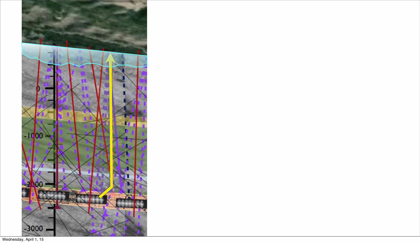
GROUNDWATER IS MOVING
Wednesday, April 1, 15

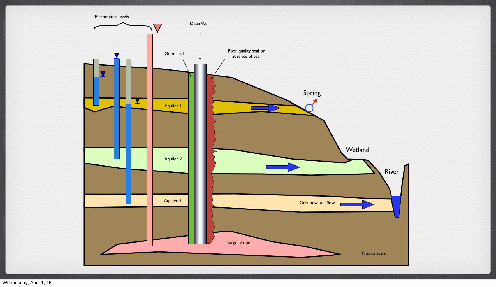
Aquifer 1
Aquifer 2
Aquifer 3
Target Zone
Piezometric levels
Spring
River
Groundwater flow
Not to scale
Wetland
Wednesday, April 1, 15

Aquifer 1
Aquifer 2
Aquifer 3
Target Zone
Piezometric levels
Spring
River
Groundwater flow
Not to scale
Wetland
Wednesday, April 1, 15

Aquifer 1
Aquifer 2
Aquifer 3
Target Zone
Piezometric levels
Spring
River
Groundwater flow
Not to scale
Wetland
Wednesday, April 1, 15

Aquifer 1
Aquifer 2
Aquifer 3
Target Zone
Piezometric levels
Spring
River
Groundwater flow
Not to scale
Wetland
Wednesday, April 1, 15

Aquifer 1
Aquifer 2
Aquifer 3
Target Zone
Piezometric levels
Spring
River
Groundwater flow
Not to scale
Wetland
Wednesday, April 1, 15

Aquifer 1
Aquifer 2
Aquifer 3
Target Zone
Piezometric levels
Spring
River
Groundwater flow
Not to scale
Deep Well
Good seal
Wetland
Wednesday, April 1, 15
Aquifer 1
Aquifer 2
Aquifer 3
Target Zone
Piezometric levels
Spring
River
Groundwater flow
Not to scale
Poor quality seal or absence of seal
Deep Well
Good seal
Wetland
Wednesday, April 1, 15

Aquifer 1
Aquifer 2
Aquifer 3
Target Zone
Piezometric levels
Spring
River
Groundwater flow
Not to scale
Poor quality seal or absence of seal
Deep Well
Good seal
Target ZoneTarget ZoneTarget ZoneTarget Zone
Wetland
Wednesday, April 1, 15

Aquifer 1
Aquifer 2
Aquifer 3
Target Zone
Piezometric levels
Spring
River
Groundwater flow
Not to scale
Poor quality seal or absence of seal
Deep Well
Good seal
Groundwater flow
Target ZoneTarget ZoneTarget ZoneTarget Zone
Wetland
Wednesday, April 1, 15

WHERE ARE THE PLAYS... AND WHERE IS GROUNDWATER?
Wednesday, April 1, 15

Ft St John
Dawson CreekHudson’s Hope
Ft Nelson
Wednesday, April 1, 15

Ft St John
Dawson CreekHudson’s Hope
Ft Nelson
Wednesday, April 1, 15

0 km 5 km 10 km 15 km 20 km
m-asl
0
1000
-1000
-2000-1000
0-1000
-1000
-1000-1000
0
-1000-1000-1000
-1000
0
-1000
0
-2000
1000
-2000-2000-2000-2000-2000
gas-bearing plays
water-bearing plays
Baldonnel (w)Halfway (g+w)Doig (g)
Montney (g)?
gas and water-bearing plays
-2000
-2000
-2000
Halfway (g+w)
190 m-aglCadotte (g+w)
490 m-bgl
formation pressure m hydraulic head
highest recorded
lowest recorded
193 m-agl
Head in BaldonnelHead in BaldonnelHead in Cadotte
490 m-bgl
Head in BaldonnelHead in Baldonnel
Head in Halfway
Baldonnel (w)
65 MPa6500 m (w)
Wednesday, April 1, 15

SO, WHAT ARE THE RISKS ?
Wednesday, April 1, 15

The well integrity issue
Well integrity refers to the degree in which a well is sealed to prevent leakage of fluids, such as gas, from depth.
Well integrity is likely the most important shale gas issue:
• groundwater contamination
• climate change
(Source: John Cherry, Munk School of Global Affairs, May 2014)
Wednesday, April 1, 15

Scenario for stray gas plume
• Where the cracked cement intersect a permeable bed, lateral gas migration occurs
• Gas migration away from the well via natural fractures in the rock or other pathways
Domestic Well
gas plume
(Source: John Cherry, Munk School of Global Affairs, May 2014)
Wednesday, April 1, 15

May 2014
Wednesday, April 1, 15

Wednesday, April 1, 15

Abandoned
Cancelled
Well Head and Activity
Active
Gas Testing
Well Shaft
Completed Suspended
Cased Well Authority Granted
Sump Source Water Well
2 km
Wednesday, April 1, 15

0 km 5 km 10 km 15 km 20 km
m-asl
0
1000
-1000
-2000-1000
0
0
-1000
0
-2000
1000
-2000-2000-2000-2000-2000
water-bearing plays
gas and water-bearing plays
gas-bearing plays
-3000
-4000
-3000
-3000
-3000
-2000
-1000
0
-4000-3000
-2000
-2000
-1000
AbandonedActive
Completed Suspended
Source Water Well - depths
unknownProjection of well near the cross-section
Cased
Wednesday, April 1, 15

0 km 5 km 10 km 15 km 20 km
m-asl
0
1000
-1000
-2000-1000
0
0
-1000
0
-2000
1000
-2000-2000-3000
-4000
-3000
-3000
-3000
-2000
-1000
0
-4000-3000
-2000
-2000
-1000
(Note: location of future O&G wells is for illustration purposes)
In 5 or 10 years...
Wednesday, April 1, 15

0 km 5 km 10 km 15 km 20 km
m-asl
0
1000
-1000
-2000-1000
0
0
-1000
0
-2000
1000
-2000-2000-3000
-4000
-3000
-3000
-3000
-2000
-1000
0
-4000-3000
-2000
-2000
-1000
(Note: location of future O&G wells is for illustration purposes)
In 5 or 10 years...
0
-1000-1000
-2000-2000-2000-2000-2000-2000
-3000
Wednesday, April 1, 15

Wednesday, April 1, 15
Wednesday, April 1, 15

Wednesday, April 1, 15

Wednesday, April 1, 15

Cadotte (g+w)
500 m-bgl
2030... 2050
Wednesday, April 1, 15

Cadotte (g+w)
500 m-bgl
2030... 2050
Wednesday, April 1, 15

Cadotte (g+w)
500 m-bgl
2030... 2050
Wednesday, April 1, 15

Low river level
Aquifers provide flow and temperature control!
Wednesday, April 1, 15

Low river level
Aquifers provide flow and temperature control!
Wednesday, April 1, 15

Montney
In 20, 30, ... , 50 years
Wednesday, April 1, 15

Montney
In 20, 30, ... , 50 years
Wednesday, April 1, 15

ARE THE RISKS.... REAL?
Wednesday, April 1, 15

WATER ALLOCATION
Wednesday, April 1, 15

OGC Northeast Water Tool
Wednesday, April 1, 15

Wednesday, April 1, 15

Northeast Water Assessment Tool (NEWT) Query
Disclaimer: The NorthEast Water Tool (NEWT) has been developed and placed on this website by theOil and Gas Commission (Commission) for the convenience of industry and the public.Information relating to NEWT is believed to be representative, but technical inaccuraciesand uncertainties may occur. NEWT carries no guarantee of any kind, express or implied.The Commission accepts no liability or blame for loss or damages incurred by any person orbusiness entity based on the use of NEWT.
Query Location:UTM-EASTING 559637UTM-NORTHING 6218547NAME Lynx CreekDATE Mon Jan 7 2013
Query WatershedDrainage Area: 5,028 haAverage Annual Precipitation: 561.3 mmAverage Elevation (m): 858.8 mBasin Centre - Easting: 555621 mBasin Centre - Northing: 6218396 mAverage Annual Unit Runoff: 128.2 mmAverage Annual Volume Runoff: 6,445,769 m!Average Annual Discharge: 0.2 m!/s
Month
AverageRunoff(mm)
AverageDischarge
(m!/s)Average Runoff
(m!)
Reserved forEnvironmental
Flow (m!)
PotentialMaximum
Allocation (m!)
Existing Allocation(Licenses or
Approvals) (m!)
RemainingPotential for
Allocation (m!) Note
Jan 1 0.02 50,529 42,950 7,579 564 7,016 Winter Flow Limited
Feb 0.9 0.02 43,291 36,798 6,494 509 5,985 Winter Flow Limited
Mar 1.3 0.03 67,702 57,546 10,155 564 9,592 Winter Flow Limited
Apr 6.6 0.13 330,148 280,626 49,522 546 48,977
May 37.4 0.7 1,879,099 1,597,234 281,865 564 281,301
Jun 31.8 0.62 1,597,300 1,357,705 239,595 546 239,049
Jul 23.7 0.44 1,190,973 1,012,327 178,646 564 178,082
Aug 11.2 0.21 563,831 479,256 84,575 564 84,011
Sep 7.4 0.14 372,962 317,017 55,944 546 55,399
Oct 3.8 0.07 193,148 164,176 28,972 564 28,409
Nov 1.9 0.04 95,160 80,886 14,274 546 13,728
Dec 1.2 0.02 61,626 52,382 9,244 564 8,680 Winter Flow Limited
Annual 128.2 0.2 6,445,769 5,478,904 966,865 6,637 960,228
Monthly Runoff (m!)Potential Maximum Allocation (m!)Reserved for Environmental Flow (m!)
OGC Water Management BasinDrainage Area: 32,202 haAverage Annual Precipitation: 539.2 mmAverage Elevation (m): 786.9 mBasin Centre - Easting: 559882 mBasin Centre - Northing: 6221366 mAverage Annual Unit Runoff: 106.9 mmAverage Annual Volume Runoff: 34,438,919 m!Average Annual Discharge: 1.09 m!/s
Month
AverageRunoff(mm)
AverageDischarge
(m!/s)Average Runoff
(m!)
Reserved forEnvironmental
Flow (m!)
PotentialMaximum
Allocation (m!)
Existing Allocation(Licenses or
Approvals) (m!)
RemainingPotential for
Allocation (m!) Note
Jan 0.7 0.09 239,200 203,320 35,880 1,127 34,753 Winter Flow Limited
Feb 0.7 0.09 209,539 178,108 31,431 1,018 30,413 Winter Flow Limited
Mar 1.1 0.13 342,197 290,867 51,329 1,127 50,202 Winter Flow Limited
Apr 5.6 0.69 1,793,606 1,524,565 269,041 1,091 267,950
May 33.2 4 10,703,197 9,097,717 1,605,480 1,127 1,604,352
Jun 26.1 3.24 8,394,981 7,135,733 1,259,247 75,100 1,184,147
Jul 19.1 2.29 6,142,936 5,221,496 921,440 75,136 846,304
Aug 9 1.08 2,901,872 2,466,591 435,281 75,136 360,145
Sep 6 0.75 1,942,323 1,650,974 291,348 25,761 265,588
Oct 3.1 0.37 994,681 845,479 149,202 1,127 148,075
Nov 1.5 0.19 479,865 407,885 71,980 1,091 70,889
Dec 0.9 0.11 294,522 250,344 44,178 1,127 43,051 Winter Flow Limited
Annual 106.9 1.09 34,438,919 29,273,081 5,165,838 259,970 4,905,867
Monthly Runoff (m!)Potential Maximum Allocation (m!)Reserved for Environmental Flow (m!)
Lynx Creek
Disclaimer: The NorthEast Water Tool (NEWT) has been developed and placed on this website by the Oil and Gas Commission (Commission) for the convenience of industry and the public.
LEGEND
Existing Water Licence POD
Existing Section 8 POD
Query Point
Query Watershed
OGC Assumption: Safe to take 15% of the flow
Wednesday, April 1, 15
!"#!"#
$%"#&'"#
$"#
()*+#
,-.+/#
0-/+)12345+/#
6)-+/#078/9+#:8;78-#
6)-+/#0-7/);+#04-+#
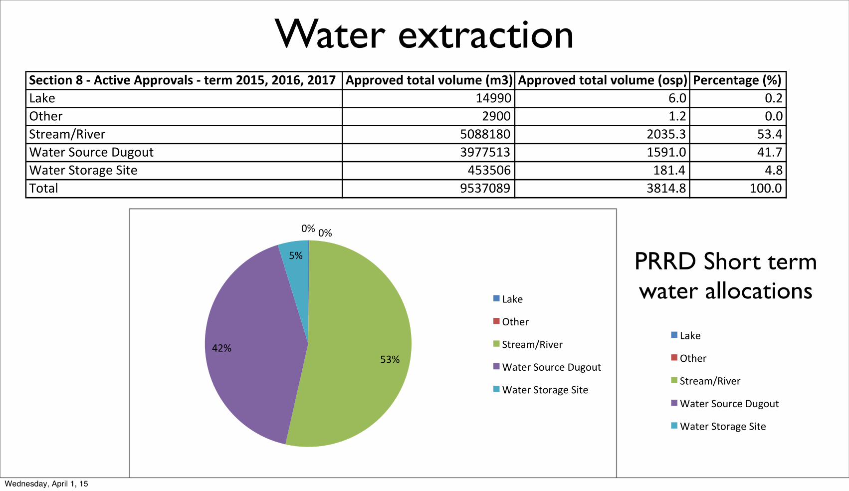
!"#$%&'()(*(+#$%,"(+--.&,/01(*($".2(34567(34587(3459 +--.&,":($&$/0(,&0;2"(<2=> +--.&,":($&$/0(,&0;2"(<&1-> ?".#"'$/@"(<A>!"#$ %&''( )*( (*+,-.$/ +'(( %*+ (*(0-/$"12345$/ 6(77%7( +(86*8 68*&9"-$/:0;</=$:><?;<- 8'@@6%8 %6'%*( &%*@9"-$/:0-;/"?$:04-$ &686() %7%*& &*7A;-"B '68@(7' 87%&*7 %((*(
PRRD Short term water allocations
Water extraction
!"#!"#
$%"#&'"#
$"#
()*+#
,-.+/#
0-/+)12345+/#
6)-+/#078/9+#:8;78-#
6)-+/#0-7/);+#04-+#
Wednesday, April 1, 15

DISPOSAL WELLS
Wednesday, April 1, 15

Wednesday, April 1, 15

LEGENDVolume of water disposed
(osp)
Wednesday, April 1, 15

13
23
37
14
50
42
10
0
10
20
30
40
50
60
1951-1960 1961-1970 1971-1980 1981-1990 1991-2000 2001-2010 2011-2014
Num
ber o
f wel
ls
Drilling decade
Number of Wells Used for Disposal, By Drilling Date (BC)
Wednesday, April 1, 15

1,847
23,791
4,443
1,316
6,679
3,812
671
0
5,000
10,000
15,000
20,000
25,000
1951-1960 1961-1970 1971-1980 1981-1990 1991-2000 2001-2010 2011-2014
Volu
me
of li
quid
dis
pose
d of
(OSP
)
Drilling decade of disposal wells
For Wells Drilled in Each Decade, How Much Waste Has Been Injected? (BC)
OSP = Olympic Swimming Pool = 2,500 m3
Wednesday, April 1, 15

200
0.00
-200
-400
-600
-800
-1000
-1200
-1400
-1600
-1800
-2000
400
600
Dep
th m
.a.s.
l.
KAKISA
BUCKING HORSE
SCATTER
SHUNDA
EXSHAWKOTCHOTETCHO
TROUT RIVER
FORT SIMPSON
MUSKWA
DEBOLT
WAN: 2240
Water disposal wellDrilled 1967-1968
Volume disposed (1968-6/2013):41 M m³ (16,500 O.S.P.)
BANFF
SLAVE POINT -1632
-1759
Open hole/barefoot completionDiamter: 159 mm (6")
Surface casing (Grade J55)Diameter: 340 mm (13")
Intermediate casing (Grade J55)Diameter: 245 mm (10")
Production casing (Grade N80)Diameter: 178 mm (7")
214
-299
End of hole
Injection of liquid
Valves
DESCRIPTION
Cement sheath
• Casing Collar Log - 2003. Interval depth -1486 to -1604 masl (1890 to 2008 m depth)
An Extraordinary Example: Well 2240Drilled/completion 1967-1968
Last Test completed on well 2240
Well WAN: 2240
16,494 OSP = 41 Billion litres, 39% of all liquid waste disposed of in BC
Wednesday, April 1, 15

Z
Z’
0 10 20 30 km
03010Orefyn Energy Advisors Corp.
Disposal Well - ActiveWater to Halfwayat Depth 1510 m
Ground Elev 683 m asl
00181Penn West Petroleum Ltd.
Disposal Well - Suspended (2004)Water to Halfwayat Depth 1495 m
Ground Elev 670 m asl
0 m asl
-1000
-500
500
0 m asl
-1000
-500
-1500
500
0 m asl
-1000
-500
500
0 m asl
-1000
-500
-1500
500
0 m asl
-1000
-500
-1500
500
Note: depths and thicknesses of formations are approximate, extrapolated from the GeoScience BC Report 2011-11
Approximate Paleovalley
Peace River
Pine River
Moberly River
water-bearing plays
gas and water-bearing plays
gas-bearing plays Z-Z’
Lower Cretaceous (g)
Nikanassin (g+w)
Baldonnel (w)
Halfway (g+w)
Doig (g)
Montney (g)
Gething (g+w)
(?)
Spirit River (g+w)
Harmon (g+w)Peace River (g+w)
Cadomin (g+w)
(?)
~ 256 OSP of liquid waste disposed off(181: 111 OSP and 3010: 145 OSP)
drilled in 1971
Wednesday, April 1, 15

Z
Z’
0 10 20 30 km
03010Orefyn Energy Advisors Corp.
Disposal Well - ActiveWater to Halfwayat Depth 1510 m
Ground Elev 683 m asl
00181Penn West Petroleum Ltd.
Disposal Well - Suspended (2004)Water to Halfwayat Depth 1495 m
Ground Elev 670 m asl
0 m asl
-1000
-500
500
0 m asl
-1000
-500
-1500
500
0 m asl
-1000
-500
500
0 m asl
-1000
-500
-1500
500
0 m asl
-1000
-500
-1500
500
Note: depths and thicknesses of formations are approximate, extrapolated from the GeoScience BC Report 2011-11
Approximate Paleovalley
Peace River
Pine River
Moberly River
water-bearing plays
gas and water-bearing plays
gas-bearing plays Z-Z’
Lower Cretaceous (g)
Nikanassin (g+w)
Baldonnel (w)
Halfway (g+w)
Doig (g)
Montney (g)
Gething (g+w)
(?)
Spirit River (g+w)
Harmon (g+w)Peace River (g+w)
Cadomin (g+w)
(?)
~ 256 OSP of liquid waste disposed off(181: 111 OSP and 3010: 145 OSP)
drilled in 1956!!
drilled in 1971
Wednesday, April 1, 15
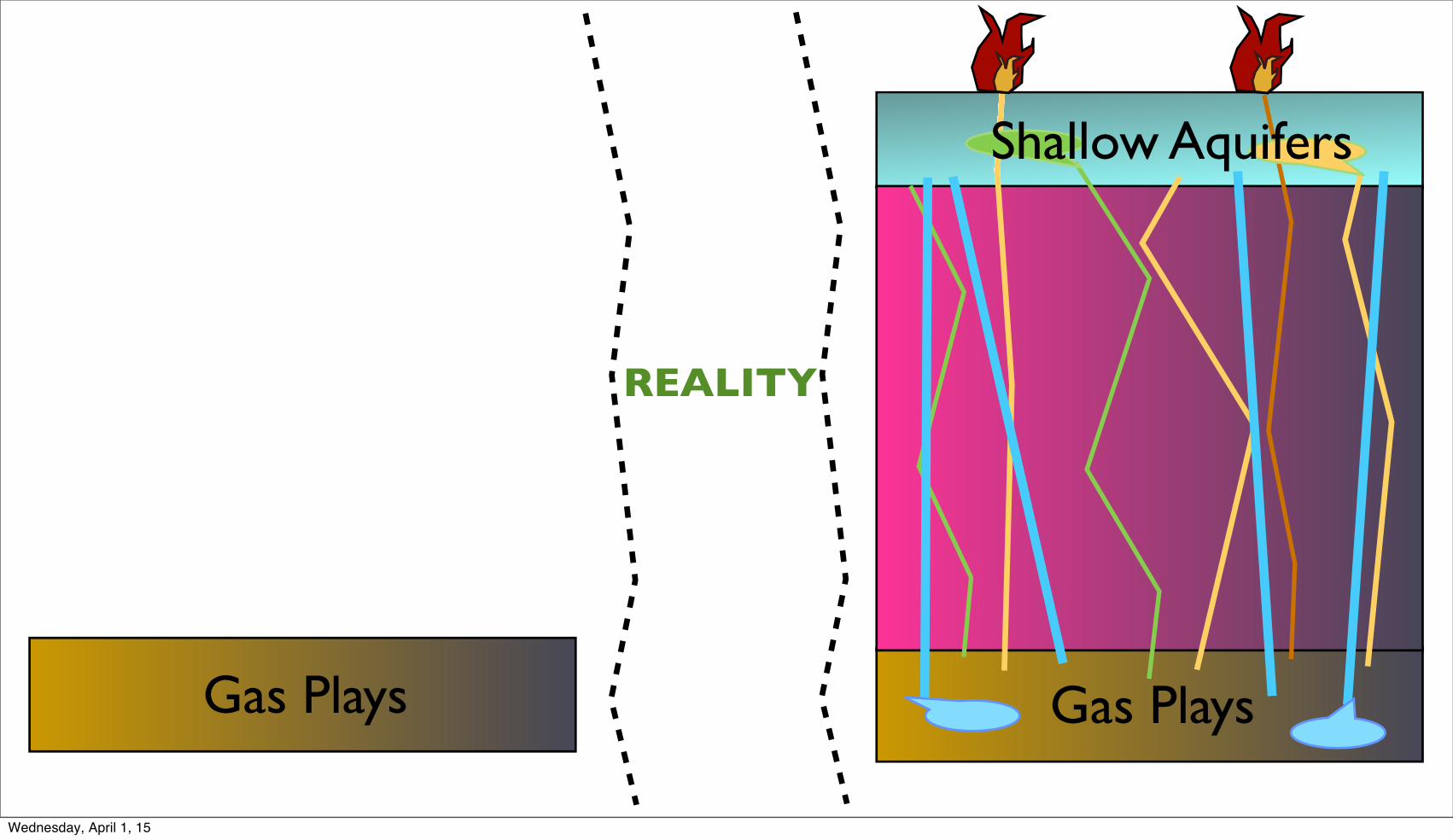
Gas Plays Gas Plays
REALITY
Shallow Aquifers
Wednesday, April 1, 15

Shallow Aquifers
Gas Plays Gas Plays
REALITY
Shallow Aquifers
Wednesday, April 1, 15

Shallow Aquifers
Gas Plays
“ Don’t worry ....Everything is under
control”
Gas Plays
REALITY
Shallow Aquifers
Wednesday, April 1, 15

WHAT WE SHOULD KNOW
Wednesday, April 1, 15

Disposal well Drilling padDugouts
Drinking Water Well
Creek
Conceptual image of groundwater dynamic and connection to surface water
Shallow sand aquifer
Deeper sand aquifer
Wednesday, April 1, 15

0 km 5 km 10 km 15 km 20 km
m-asl
0
1000
-1000
-2000-1000
0-1000
-1000
-1000-1000
0
-1000-1000-1000
-1000
0
-1000
0
-2000
1000
-2000-2000-2000-2000-2000
gas-bearing plays
water-bearing plays
Peace River (g+w)
Spirit River (g+w)
Bluesky (g+w)Gething (g+w)Cadomin (g+w)Nikanassin (g+w)
Baldonnel (w)
Halfway (g+w)Doig (g)
Montney (g)
?
gas and water-bearing plays
-2000
-2000
-2000
Montney (g)
2060 m-agl
Doig (g)
650 m-agl Halfway (g+w)
190 m-agl
Cadomin (g+w)
20 m-bgl
Gething (g+w)
600 m-bgl
Bluesky (g+w)
10 m-agl
Falher A (g+w)
580 m-bgl
Cadotte (g+w)
490 m-bgl
formation pressure m hydraulic head
highest recorded
lowest recorded
193 m-agl
Head in BaldonnelHead in BaldonnelHead in Cadotte
190 m-agl(g+w)
20 m-bgl
Gething (g+w)
600 m-bgl
Bluesky (g+w)
10 m-agl
Falher A (g+w) Cadotte
(g+w)
490 m-bglHead in BaldonnelHead in Baldonnel
Head in Halfway
Wednesday, April 1, 15

0 km 5 km 10 km 15 km 20 km
m-asl
0
1000
-1000
-2000-1000
0
0
-1000
0
-2000
1000
-2000-2000-3000
-4000
-3000
-3000
-3000
-2000
-1000
0
-4000-3000
-2000
-2000
-1000
(Note: location of future O&G wells is for illustration purposes)
Wednesday, April 1, 15
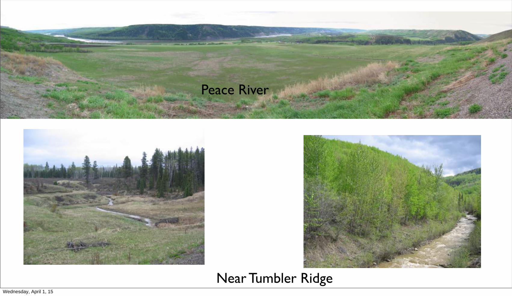
Peace River
Near Tumbler RidgeWednesday, April 1, 15

dry river - dry bridge
Wednesday, April 1, 15

T H A N K Y O UPhoto: Gilles Wendling
Wednesday, April 1, 15