groundwater vulnerability to pollution in urban catchments
TRANSCRIPT

GROUNDWATER VULNERABILITY TO POLLUTION IN URBAN CATCHMENTS
Report to the WATER RESEARCH COMMISSION
by
O T N Sililo and I C Saayman
The Water Programme Division of Water, Environment and Technology
CSIR
and
MV Fey
Department of Geology University of Cape Town
WRC Project No 1008/1/01
ISBN 1 86845 783 4
JULY 2001

Groundwater Vulnerability To Pollution Page i
EXECUTIVE SUMMARY
INTRODUCTION
South Africa has limited water resources that are unevenly distributed. Some areas are already experiencing water stress, and competition among various activities for use of water has become more intense, requiring better management of the resource. Although groundwater contributes only about 15 per cent of total water consumption, two-thirds of the country, including more than 280 towns and settlements, mostly in the drier parts, are largely dependent on groundwater. The importance of groundwater continues to grow across the country because of its generally easy availability, cost effectiveness and dwindling surface water resources. It is therefore very important that measures are put in place to protect existing water resources from pollution. The importance of protecting water from pollution has been recognized by the national government and measures have already been proposed through legislation to effect this. The Department of Water Affairs and Forestry has published a policy and strategy document for groundwater management in South Africa The department proposes to achieve groundwater protection goals through a combination of source-directed measures, resource-directed measures and rehabilitation measures.
Background to present project
Groundwater contamination often occurs as a result of various anthropogenic activities. The vulnerability of an aquifer to such pollution is directly linked to hydraulic characteristics of the aquifer overburden and to a significant degree determined by the characteristic of contaminant attenuation. The degree/extent of interactions between the soil/aquifer characteristics and the pollutants will determine the vulnerability of an aquifer to pollution. Defining the extent of such interactions requires a multitude of physical, chemical and sometimes biological parameters for both the porous medium and the pollutant of interest. The WRC has funded a number of projects to address certain aspects of these issues. One of the projects investigated the contaminant attenuation capacity of the soil/aquifer system with special emphasis on the vadose zone. This project focussed on the contaminant attenuation characteristics of the subsurface. Another WRC project: “The relationship between geotechnical and hydrogeological properties of residual soils and rocks in the vadose zone”. has recently been completed. The main objective of this project was to identify the hydrogeological properties of soils and rocks in the vadose zone which affect aquifer recharge and pollution. Thus this project contributed to our understanding of the accessibility of the saturated zone. Significant progress has thus been made in understanding the processes, and in identifying the most important parameters. Further work is still required to provide data, and ultimately guidelines that can be used for management purposes. Against this background, the WRC funded a project: “Protocols for assessing groundwater pollution impacts – formulation of a research strategy” during 1999. The main aim of this project was to formulate a research strategy that the WRC would use as a basis for funding research in this field. In developing this strategy, the WRC recommended that all major role players should be consulted and consensus obtained. It was also decided to focus the strategy mainly on urban areas, where intensive land-use, as a consequence of increased human settlement and economic development, can have a serious negative impact on groundwater quality. The following objectives were set:
1. to summarize current state of the art methodologies for determining groundwater pollution impacts of anthropogenic activities.
2. to summarize current approaches used in South Africa and identify any limitations. 3. to define a suitable methodology and consequently to formulate a research strategy.

Groundwater Vulnerability To Pollution Page ii
4. to hold a workshop to obtain consensus from the role players on the suggested methodology and research strategy.
Objective 1 relates to groundwater vulnerability assessment with emphasis on assessment techniques. Objective 2 requires that we examine whether these techniques have been applied in South Africa. This initiative by the WRC is particularly relevant to DWAFs source-directed strategies. Specifically, in Section 3.4 of DWAF’s groundwater management strategy document, the department proposes to effect its policy goals through, among other things:
• establishing an understanding of the importance and vulnerability to pollution of the country’s groundwater resources, and
• establishing an understanding of the relationship between polluting activities (sources) and quality effects in the groundwater, i.e. understanding the origin of pollutants, the pathways which these pollutants could follow into the environment and the ultimate fate of these pollutants.
These aspects were at the centre of this study.
METHODOLOGY
This one year research project was conducted by two research institutions: CSIR and University of Cape Town. It is important to point upfront, that this report does not address all aspects of groundwater pollution or protection. It focuses mainly on groundwater vulnerability assessment with emphasis on soils and the unsaturated zone. Risk based approaches are not addressed. The activities conducted to meet the objectives above are given below.
Review of groundwater pollution in urban areas
The vulnerability assessment approach discussed here requires information on the source of contaminants. It was therefore important to provide an overview of sources, characteristics, fate and transport of groundwater contaminants, including approaches to contaminant source mapping. Emphasis was on urban areas. An assessment was also made on our current knowledge of the source aspect in South Africa. From this, research gaps were identified.
Review of approaches to vulnerability assessment
Vulnerability assessments provide a systematic way for evaluating how readily and quickly aquifers receive water (and contaminants) from the land surface. A review was made on current approaches to groundwater vulnerability assessments internationally and in South Africa. Research needs were then identified.
Utilization of available soils information in vulnerability assessment
Because of the importance of soils information in vulnerability assessments, this topic was given considerable attention in this study. The use of available soils information in vulnerability assessment was explored and a framework proposed for further research.

Groundwater Vulnerability To Pollution Page iii
Workshop and visits to institutions/consultants
As indicated above, the WRC had recommended that before a research strategy is finalized, all major role players should be consulted and consensus obtained. To achieve this, a number of visits were undertaken to a number of groundwater practitioners and institutions to discuss research needs in the field of groundwater protection. A workshop was also held with a group of experts to discuss proposed research areas.
Research strategy
A research agenda, which will form part of WRC’s Programme on Groundwater Protection, was developed based upon · Data requirements for assessing groundwater vulnerability to pollution · Recommendations from different role players · DWAFs source-based strategies
CONCLUSIONS AND RECOMMENDATIONS
Groundwater pollution
From the assessment conducted, it is clear that more research is still required to improve our understanding of the pollution source component in vulnerability studies. It is concluded that there is urgent need to identify and prioritise the type of contaminants and their associated sources which present the greatest threat to groundwater in South Africa. Once identified, such contaminants (and sources) must be given priority in future research/technology transfer. Another aspect deemed important relates to detection and evaluation of groundwater contamination caused by organic chemicals. It was noted that individual organic contaminants are rarely determined during groundwater pollution investigations. There is urgent need to assess the extent of the problem and ultimately develop guidelines for detection and evaluation of contamination caused by these chemicals.
Groundwater Vulnerability
From the review, it was clear that no single methodology was suitable on its own and we recommend a combination of
• Intrinsic vulnerability assessment which focus on hydrogeologic settings and the natural protection against contamination provided by physical characteristics, and
• Specific vulnerability assessment which focus on the properties of specific contaminants and their behaviour in the subsurface environment.
It was also clear that most of the methods that have been reported in the literature to assess vulnerability of groundwater to pollution have not been applied in South Africa. It is concluded that there is urgent need to test various methods for vulnerability assessment to determine which methods are most appropriate in different hydrogeological environments at different scales.

Groundwater Vulnerability To Pollution Page iv
Use of available soils information
The usefulness of soils information in vulnerability assessments is demonstrated. Specifically, the possibility of drafting a preliminary soil classification based on current knowledge is demonstrated, emphasising the important inferences (including climatic and hydrological ones) which can be drawn from pedogenic information inherent in the current, general purpose, classification system. A framework is proposed for further research that will provide a basis for incorporating available soils information into the assessment of groundwater vulnerability to contamination.
Research recommendations
We believe that the projects outlined below, if conducted, will contribute significantly to the implementation of DWAF’s groundwater management strategy. The research areas are thus discussed in terms of the following programmes DWAF intends to initiate:
1. National Information Programme and Aquifer Management Programme 2. Aquifer Classification Programme
National Information Programme and Aquifer Management Programme
In terms of DWAF’s agenda, the projects described below will contribute to “establishing an understanding of the relationship between polluting activities (sources) and quality effects in the groundwater, i.e. understanding the origin of pollutants, the pathways which these pollutants could follow into the environment and the ultimate fate of these pollutants”. National groundwater contamination inventory: to document, with existing data, the extent, spatial distribution, propagation and types of contaminants and their associated sources which present the greatest threat to groundwater. There is urgent need to identify and prioritise the type of contaminants and their associated sources which present the greatest threat to groundwater in South Africa. Once identified, such contaminants (and sources) must be given priority in future research. Detection and Evaluation of groundwater contamination caused by organic chemicals in urban areas of South Africa. Individual organic contaminants are rarely analysed for during groundwater pollution investigations. Thus the extent of the problem is not known. Organic contaminants may cause harmful effects at very low concentrations. There is urgent need to assess the extent of the problem and ultimately develop guidelines for detection and evaluation of contamination caused by organic chemicals. Determine the contaminant attenuation potential of different hydrogeological environments for contaminants of concern. For example, for microbiological contaminants, determine their survival times in the subsurface. Develop guidelines for site characterization and monitoring at contaminated sites. There is need to develop standard guidelines (minimum requirements) for site characterization and monitoring during pollution investigations.

Groundwater Vulnerability To Pollution Page v
Aquifer classification programme
“South African groundwater protection will be based on a differentiated approach, which distinguishes between aquifers. - Bullet 4, Section 3.4, DWAF, 2000. The projects described below will help “establish an understanding of the importance and vulnerability to pollution of the country’s groundwater resources”. . Develop improved methods for vulnerability assessments, and ultimately develop guidelines for conducting vulnerability assessments. There is need to determine which processes are the most important to incorporate into vulnerability assessments in different hydrogeological environments and at different spatial scales. The validity of using different methods, including DRASTIC which has been applied in South Africa, must be tested Develop methods for using available soils information in vulnerability assessments. There is need for assessment of the pollutant attenuation capacity of soil horizons and other regolith materials and a description of the diagnostic value of key morphological and chemical properties of soils which automatically convey information on contaminant transport potential. There is also need for a special purpose classification of SA soils based on the binomial system with attenuation capacity ratings as a basis for higher order groupings. Develop methods for combining soils information and geologic information in vulnerability assessments. There is need to integrate soil and geologic information in vulnerability assessments. Both are important and need to be incorporated in assessment approaches. Develop methods for merging data obtained at different spatial and temporal scales into a common scale for vulnerability assessment. It is unlikely that all data will be collected at the same spatial or temporal scale. It is thus very important to develop methods that permit data collected at one scale to be transformed to a scale appropriate for a given assessment approach Develop improved approaches to quantifying groundwater recharge in urban catchments. Urbanization causes radical changes in groundwater recharge by modifying existing mechanisms and introducing new ones. An understanding of these mechanisms is crucial in groundwater vulnerability assessments in urban areas. Establishing simple, practical, and reliable methods for measuring (or estimating) in situ hydraulic conductivity of the unsaturated zone. This information is of primary importance in determining flow of water (and contaminants) in the subsurface. Developing methods for accounting for preferential flow pathways in the unsaturated zone. Routes of transport that circumvent the porous media have a profound effect on flow and are difficult to quantify. It is important to identify areas where preferential flow will be dominant, and develop methods for quantifying the effects of this mechanism in such areas.
Implementation
The projects identified here are critical to establishing an improved understanding of the relationship between polluting activities (sources) and quality effects in the groundwater, i.e. understanding the origin of pollutants, the pathways which these pollutants could follow into the environment and the ultimate fate of these pollutants. We therefore recommend that researchers should be encouraged to put in proposals on any of these projects
Groundwater Vulnerability To Pollution Page vi
ACKNOWLEDGEMENTS
We would like to thank the following for their inputs into this project:
• The Water Research Commission for funding the project
• The following members of the steering committee of the project for their advice and support:
Mr K Pietersen Water Research Commission Mr H M du Plessis Water Research Commission Dr G Tredoux Environmentek, CSIR Dr Y Xu Geohydrology, DWAF Prof. A van Schalkwyk University of Pretoria Mr N Meyer Cape Metropolitan Council
• the following who participated in the workshop:
Kevin Pietersen Water Research Commission Carl Stein ISCW Mike Smart Department of Water Affairs & Forestry A van Schalkwyk University of Pretoria Ritchie Morris MEGA Consulting Gideon Tredoux CSIR
• the following for their fruitful discussions on the research strategy: Eberhard Braune, Manda
Hinsch, Georgina King, Roger Parsons. • Christine Colvin for helpful comments on the final document.

Groundwater Vulnerability To Pollution Page vii
TABLE OF CONTENTS
EXECUTIVE SUMMARY...................................................................................................................... i
ACKNOWLEDGEMENTS................................................................................................................... vi
TABLE OF CONTENTS ..................................................................................................................... vii
CHAPTER 1: INTRODUCTION..........................................................................................................1
1.1. Preamble............................................................................................................................1.1
1.2. Background to present project ........................................................................................1.1
1.3. Approach and report layout ............................................................................................1.2
1.4. Relationship to DWAF’s Groundwater Management Strategy ...................................1.3
CHAPTER 2: GROUNDWATER POLLUTION...............................................................................2.1
2.1. Introduction ......................................................................................................................2.1
2.2. Pollution Sources ..............................................................................................................2.1 2.2.1. Municipal ..........................................................................................................................2.2 2.2.2. Industry and Mining ..........................................................................................................2.7 2.2.3. Agriculture ........................................................................................................................2.9
2.3. Pollution Attenuation .....................................................................................................2.11
2.4. Contaminant Source Mapping ......................................................................................2.13 2.4.1. Estimation of pollution load from urban residential areas ..............................................2.14 2.4.2. Estimation of pollution load of industrial activity...........................................................2.14 2.4.3. Estimation of contaminant load of lagoons.....................................................................2.14
2.5. Discussion of Research Areas ........................................................................................2.14
CHAPTER 3: GROUNDWATER VULNERABILITY......................................................................3.1
3.1. Introduction ......................................................................................................................3.1
3.2. Vulnerability assessment procedures..............................................................................3.1
3.3. Data requirements ...........................................................................................................3.3 3.3.1. Meteorological ..........................................................................................................3.4 3.3.2. Land surface..............................................................................................................3.5 3.3.3. Soil layer ...................................................................................................................3.5 3.3.4. Vadose zone...............................................................................................................3.5 3.3.5. Saturated zone............................................................................................................3.6 3.3.6. Pollutant specific information....................................................................................3.6
3.4. Scale of assessment ...........................................................................................................3.6
3.5. Recommended Approach.................................................................................................3.8 3.5.1. Intrinsic Vulnerability Assessment ...........................................................................3.8

Groundwater Vulnerability To Pollution Page viii
3.5.2. Specific Vulnerability assessment .............................................................................3.8
CHAPTER 4: SOIL INFORMATION IN VULNERABILITY ASSESSMENT..............................4.1
4.1. Introduction ......................................................................................................................4.1
4.2 Assumptions .............................................................................................................................4.1
4.3. Assessment of soil horizons in relation to recharge and vulnerability.........................4.2
4.5 Groundwater vulnerability classification of South African soil forms ...............................4.5
4.6. Proposed research strategy.............................................................................................4.7
CHAPTER 5: RESEARCH STRATEGY...........................................................................................5.1
5.1 Introduction .............................................................................................................................5.1
5.2 Research Agenda .....................................................................................................................5.2 5.2.1. National Information programme and Aquifer management Programme.........................5.2 5.2.2. Aquifer classification programme .....................................................................................5.3
5.3 Implementation........................................................................................................................5.4
CHAPTER 6: DISCUSSION AND CONCLUSIONS .......................................................................6.1
REFERENCES ......................................................................................................................................1

Chapter 1: Introduction
Groundwater Vulnerability To Pollution Page 1.1
CHAPTER 1: INTRODUCTION
1.1. Preamble
South Africa has limited water resources that are unevenly distributed. Some areas are already experiencing water stress, and competition among various activities for use of water has become more intense, requiring better management of the resource. Although groundwater contributes only about 15 per cent of total water consumption, two-thirds of the country, including more than 280 towns and settlements, mostly in the drier parts, are largely dependent on groundwater. The importance of groundwater continues to grow across the country because of its generally easy availability, cost effectiveness and dwindling surface water resources. It is therefore very important to put measures in place to protect existing water resources from pollution. The importance of protecting water from pollution has been recognized by the national government and measures have already been proposed through legislation to effect this (The National Water Act, Act 36 of 1998; The National Environmental Management Act No 107 of 1998). The Department of Water Affairs and Forestry has published a policy and strategy document for groundwater management in South Africa (DWAF 2000). The department proposes to achieve groundwater protection goals through a combination of source-directed measures, resource-directed measures and rehabilitation measures.
1.2. Background to present project
Groundwater contamination often occurs as a result of various anthropogenic activities. The vulnerability of an aquifer to such pollution is directly linked to (Foster, 1987):
i. accessibility of the saturated zone, in a hydraulic sense, to the penetration of mobile contaminants.
ii. Attenuation capacity, as a result of physicochemical retention or reaction of pollutants. These two components interact primarily with the following respective components of subsurface pollution loading (Foster, 1987):
iii. the manner of pollutant disposition iv. the physicochemical mobility and persistence of the pollutant
The degree/extent of interactions between the soil/aquifer characteristics and the pollutant (components (i) – (iv)) will determine the vulnerability of an aquifer to pollution. Defining the extent of such interactions requires a multitude of physical, chemical and sometimes biological parameters for both the porous medium and the pollutant of interest. The WRC has funded a number of projects to address certain aspects of these issues. One of the projects investigated the contaminant attenuation capacity of the soil/aquifer system with special emphasis on the vadose zone (Sililo et al. 1999b). Viewed in terms of Fosters description above, the project focussed on the contaminant attenuation characteristics of the subsurface (components (ii) and (iv). Another WRC project: “The relationship between geotechnical and hydrogeological properties of residual soils and rocks in the vadose zone”. has recently been completed (van Schalkwyk and Vermaak, 2000). One of the main objectives of this project was to identify the hydrogeological properties of soils and rocks in the vadose zone which affect aquifer recharge and pollution. Thus this project contributed to our understanding of the accessibility of the saturated zone (component (i) above). Significant progress has thus been made in understanding the processes, and in identifying the

Chapter 1: Introduction
Groundwater Vulnerability To Pollution Page 1.2
most important parameters. Further work is still required to provide data, and ultimately guidelines that can be used for management purposes. Against this background, the WRC funded a project: “Protocols for assessing groundwater pollution impacts – formulation of a research strategy” during 1999. The main aim of this project was to formulate a research strategy that the WRC would use as a basis for funding research in this field. In developing this strategy, the WRC recommended that all major role players should be consulted and consensus obtained. It was also decided to focus the strategy mainly on urban areas, where intensive land-use, as a consequence of increased human settlement and economic development, can have a serious negative impact on groundwater quality The following objectives were set:
1. to summarize current state of the art methodologies for determining groundwater pollution impacts of anthropogenic activities.
2. to summarize current approaches used in South Africa and identify any limitations. 3. to define a suitable methodology and consequently to formulate a research strategy. 4. to hold a workshop to obtain consensus from the role players on the suggested methodology
and research strategy. Objective 1 relates to groundwater vulnerability assessment with emphasis on assessment techniques. Objective 2 requires that we examine whether these techniques have been applied to South Africa.
1.3. Approach and report layout
This one year research project was conducted by two research institutions: CSIR and University of Cape Town. It is important to point out upfront, that this report does not address all aspects of groundwater pollution or protection. It focuses mainly on groundwater vulnerability assessment with emphasis on soils and the unsaturated zone. Risk based approaches are not addressed. In order to address objective 1, it was necessary to provide information on sources of groundwater contaminants and approaches to vulnerability assessment. An overview of sources, characteristics, fate and transport of groundwater contaminants in the subsurface, including approaches to contaminant source mapping is given in Chapter 2. Research needs are also given. Vulnerability assessments provide a systematic way to evaluate how readily and quickly aquifers receive water (and contaminants) from the land surface. In order to understand the most important parameters that will influence transport and fate of contaminants in the subsurface, it was important to review current approaches to groundwater vulnerability assessments internationally and in South Africa. Research needs are then identified. This review is given in Chapter 3. The use of soils data to assist in evaluating fate and transport of contaminants is given in Chapter 4. This chapter also presents a preliminary qualitative assessment of soil horizons and other properties in terms of their contribution to groundwater recharge and vulnerability of groundwater to pollution. The last section of this chapter summarizes research needs. In Chapter 5, research issues which different experts consider important for groundwater protection are summarized. This is followed by a research agenda which will form a major part of WRC’s Programme on Groundwater Protection. Chapter 6 is a discussion and conclusions chapter in which an overview is given of project achievements in relation to project objectives.

Chapter 1: Introduction
Groundwater Vulnerability To Pollution Page 1.3
1.4. Relationship to DWAF’s Groundwater Management Strategy
This initiative by the WRC is particularly relevant to DWAFs source-directed strategies. In Section 3.4 of DWAF’s groundwater management strategy document, DWAF proposes to effect its policy goals through, among other things:
• establishing an understanding of the importance and vulnerability to pollution of the country’s groundwater resources, and
• establishing an understanding of the relationship between polluting activities (sources) and quality effects in the groundwater, i.e. understanding the origin of pollutants, the pathways which these pollutants could follow into the environment and the ultimate fate of these pollutants.
Clearly, these aspects relate to components (i) – (iv) as described in Section 1.2 above.

Chapter 2: Groundwater Pollution
Groundwater Vulnerability To Pollution Page 2.1
CHAPTER 2: GROUNDWATER POLLUTION
2.1. Introduction
The pollution of groundwater resources is often a consequence of poor land-use planning, resulting in the location of high risk activities in areas where they have a negative impact on groundwater resources. A holistic approach is therefore required in the management and protection of groundwater resources. Increasingly methods that protect groundwater resources are being incorporated into land-use planning, or at least considered in the approval of new developments. The development and acceptance of Environmental Impact Assessment legislation has brought the impact of developments on groundwater resources to the attention of many decision makers. Where groundwater pollution occurs, it results in the alteration and degradation of the natural quality of groundwater. A wide range of pollutants that occur in groundwater have been recognised. These include bacteria and other micro-organisms, major inorganic ions (NO3, Cl, SO4, etc.), trace ions such as heavy metals, and a wide range of organic chemicals. The more common sources of groundwater pollution are discussed in the following section.
2.2. Pollution Sources
The problems facing scientists and managers involved in the protection of groundwater resources are: • to identify areas and mechanisms by which pollutants enter groundwater flow systems, • to develop reliable predictions of the transport of pollutants within the flow systems, and • to recommend protective measures and to translate them into legal and administrative
frameworks. The use of groundwater protection zones is one way in which the protection of groundwater resources is addressed in some countries e.g. Sweden (Scharp, 1999). Groundwater contamination can occur whenever there is a source releasing contaminants to the environment. The sources of groundwater pollution are many and varied, and include:
- municipal (sewer leakage, sewage effluent, sewage sludge, urban runoff, landfill, latrines, septic tanks);
- agricultural (leached salts, fertilisers, pesticides, animal wastes); - industrial (process waters, water treatment, plant effluent, hydrocarbons, tank and pipeline
leakage); and - mining (solid wastes and liquid wastes) activities.
Table 2.1 provides a summary of the major sources of groundwater pollution with a description of some of their health risks. These are further expanded upon in the discussions that follow in the subsequent sections.

Chapter 2: Groundwater Pollution
Groundwater Vulnerability To Pollution Page 2.2
Table 2.1: Main sources of groundwater pollution with some of their main characteristics. Pollution Category Pollution Source Main Pollutant Potential impact
Sewer leakage Septic tanks, cesspools, privies
Nitrate Viruses and Bacteria
Sewage effluent and sludge
Nitrate, Minerals, Organic compounds, Viruses and Bacteria
Health risk to users, eutrophication of water bodies, odour and taste
Storm water runoff Bacteria and Viruses Health risk to water users
Landfills
Inorganic minerals, Organic compounds, Heavy metals, Bacteria and Viruses
Health risk to users, eutrophication of water bodies, odour and taste
Municipal
Cemeteries Nitrate, Viruses and Bacteria Health risk to water users
Feedlot wastes Nitrate-nitrogen-ammonia, Viruses and Bacteria
Health risk to water users (e.g. Metahemoglobinemia)
Pesticides and herbicides Organic compounds Toxic / Carcinogenic
Fertilisers Nitrogen, Phosphorous Eutrophication of water bodies.
Agriculture
Leached salts Dissolved salts Increased TDS in groundwater
Process water and plant effluent
Organic Compounds Heavy Metals
Carcinogens and toxic elements (As, Cn)
Industrial landfills
Inorganic minerals, Organic compounds, Heavy metals, Bacteria and Viruses
Health risk to users, eutrophication of water bodies, odour and taste
Leaking storage tanks (e.g. Petrol stations)
Hydrocarbons, Heavy Metals Odour and taste
Chemical transport
Industrial
Pipeline leaks Hydrocarbons, chemicals
Carcinogens and toxic compounds
Coal fired Power stations Atmospheric Deposition Vehicle emissions Acidic precipitation
Mine tailings & stockpiles Acid Drainage
Acidification of groundwater and toxic leached heavy metals Mining
Dewatering of Mine shafts Salinity, Inorganic compounds, Metals
May increase concentrations of some compounds to toxic levels.
Groundwater Development Salt Water Intrusion Inorganic minerals
Dissolved salts Steady water quality deterioration
2.2.1. Municipal
Human settlement and activity result in the generation of large quantities of waste. To manage this waste man has designed sewage networks and solid waste collection infrastructures to transfer waste

Chapter 2: Groundwater Pollution
Groundwater Vulnerability To Pollution Page 2.3
to collection and treatment centres, often at the periphery of the urban centres. At various stages during transport, treatment or disposal, these wastes may impact on the environment and result in the pollution of surface or groundwater resources. While in developing informal settlements, infrastructure for the removal of waste and sewage is often absent. Resulting in the accumulation of waste within these settlements and the pollution of water resources. Leaking domestic sewage networks The contaminant load from well designed and maintained sewage networks are often small and isolated. Where contamination does occur it is generally the result of leaks or raptures. There is often a relation between the volume leaked from sewage networks and the frequency of the ruptures to the age of the sewage network (Eiswirth, et al., 2000). Leakage is thought to occur through joints in sewer systems, with the proportion of loss though leakage on average estimated at 12% (Eiswirth et al., 2000). From the study of groundwater pollution in an urban area of Germany, leaking sewage networks was found to be the main source of groundwater contamination by sodium, chloride, and nitrogen sulphate compounds (Eiswirth et al., 2000). The contribution that leaking sewage networks make to groundwater quality in the South African urban environment is not well understood. Of interest is the relative impact that relatively young sewered areas have on groundwater quality compared to older sewered areas. Storm water runoff Studies have shown that stormwater runoff may have microbial densities similar to those found in dilute raw wastewater (Qureshi and Dutka, 1979). It has further been shown that pathogenic bacteria may be present in such runoff. Where stormwater runoff then enters water supply sources, it could have serious health impacts on water users. This may occur through discharge into a surface water body (typically a river or stream), through leakage of the pipeline or channel, or discharge to a soakaway or artificial recharge basin, which could result in groundwater pollution. In a South African study (Jagals, 1994, from Pretorius and De Villiers, 1999) it was found that an urban stormwater outfall contributes greater microbiological pollution to a receiving surface water body than the effluent from a sewage works outfall originating in the same urban area. While sewage works are guided by strict guidelines on what the quality of their outfall water may be, little monitoring of stormwater discharge quality takes place. Informal Settlements The impacts of low impact point sources are often overlooked. However, where many of these point sources occur, their cumulative impact may be significant. An example of a large cumulative impact is where pit latrines are found clustered, or residential areas lack sanitation facilities (Wright, 1999). In developing urban environments people are increasingly being clustered into informal settlements. The development of these informal settlements often occurs rapidly and in an unplanned manner. This results in settlements with only limited access to public water and sanitation. South Africa has followed the global trend towards urbanisation, with an estimated 55% of the population resident in urban areas (Palmer Development Group, 1993), many in large sprawling informal settlements. The provision of services such as housing, water supply and suitable sanitation has not been able to keep up with the high demand. A survey conducted by the Palmer Development Group (1993) found that 31% of urban residents in South Africa do not have access to adequate sanitation. Typical high-cost, low-density urban areas have sophisticated infrastructure with pollution mainly originating from point sources that can be monitored and controlled. Low-cost, high-density urban
Chapter 2: Groundwater Pollution
Groundwater Vulnerability To Pollution Page 2.4
areas have less sophisticated infrastructure, with the result that the pollution source is more diffuse and difficult to identify and control. A number of potentially polluting activities characteristic of South African informal settlements include (Wright, 1999):
• On-site sanitation systems • Garbage disposal and collection sites • Water supply points • Communal meeting sites • Informal trading sites • Stormwater drainage systems.
Wright (1999) identified the most significant pollutants identified in South African informal settlements as: Nutrients (nitrogen and phosphorous), pathogenic micro-organisms (helminths, protozoa, bacteria, and viruses) and biodegradable organics (proteins, carbohydrates and fats). Waste Disposal through landfilling The impact of waste disposal activities on groundwater in South Africa has been widely studied and documented (Tredoux, 1984; Weaver and Tworeck, 1988; Parsons, 1992; Saayman, 1998). However, compared to work done in other countries (e.g. the USA and Sweden), relatively few instances of groundwater pollution from waste disposal sites have been recognised in South Africa. This does not mean that instances of groundwater pollution are less of a problem in South Africa. Rather it reflects the relatively small number of investigations that have been conducted on the impact waste disposal activities has on groundwater quality. Where such pollution impact studies have been done they have only on rare occasions studied in detail the geochemical processes active in the leachate plume, the nature of specific organic compounds and the processes of attenuation that are taking place. Present efforts by regulatory authorities in South Africa are focused on the licensing of all existing waste disposal facilities. This process is progressing slowly, and is unlikely to cover all the presently active sites in the near future. At the same time very little monitoring is being done on the impact of closed waste sites. In many instances the location of such waste sites and informal dumpsites are no longer known; this while the generation of leachate in such waste and dump sites may continue for many years to come. The impact of waste disposal activities can be discussed under those waste disposal activities that are generated by households (i.e. domestic), and those associated with industrial activities. Domestic Waste Disposal In the UK more than 90% of all domestic and commercial solid wastes are disposed of through landfilling (Robinson and Maris, 1985). The design of landfills to protect groundwater from the impact of leachate has however only in recent years become legislated. Many South African waste disposal sites still operational today originate from dump sites. Often the only criteria for the location and design of such sites were that they would allow maximum storage, should not be in a residential suburb and that they should be readily accessible. For this reason the most commonly used disposal sites were pits, abandoned quarries, or natural land surface depressions. It is only recently that the possible impact on groundwater is being considered in the location and design of new landfill sites.

Chapter 2: Groundwater Pollution
Groundwater Vulnerability To Pollution Page 2.5
It is accepted by the designers and managers of waste disposal that they should adopt cautionary and sustainable management principles if they are to limit impacts on the environment. To achieve economic and environmental sustainability, landfills have evolved to accept mixed domestic solid waste, with their location on the appropriate hydrogeology and topography, as well as being designed, constructed and operated with the relevant hydrogeological and engineering principles (Knight, 2000). With industrialisation of society household garbage has evolved from consisting mostly of biodegradable material, to increasing levels of less degradable products, such as used batteries, used cans of various solvents, paints, poisons, etc. It is estimated that every household in the U.S. contributes more than 4.5 litres of hazardous waste to municipal sanitary landfills each year (Engelbrecht, 1993). Leachate from domestic landfills usually contain high concentrations of organic and inorganic substances. The contaminants of greatest concern are usually (from Engelbrecht, 1993):
• Dissolved organic compounds – these may be carcinogenic or toxic, and affect taste and odour.
• Nitrogen compounds – result in eutrophication problems in surface waters and high NO3 concentrations are poisonous in drinking water.
• Sodium, Potassium, chloride, calcium and magnesium are harmless to humans at normal concentrations, but ecologically harmful and may pose problems when groundwater is used for industrial purposes.
High levels of microbiological activity are observed in waste disposal sites. The harsh environment of landfills however results in a high level of organism die-off (Engelbrecht, 1993). The inactivation capacity of different leachates may vary considerably depending on various factors. However, if pathogenic bacteria, viruses, protozoa or helminths survive in the leachate, they will reach the groundwater. The health risk then becomes a function of their survival and movement through the aquifer. Industrial Waste Disposal Waste disposal remains the most cost effective way in which companies can dispose of their industrial waste. Legislation strictly regulates industrial waste, and means that such waste is only be accepted at facilities authorised to do so. The specialised nature and the high standards demanded of such waste sites means that high charges are levied from users. Where the cost of such dumping (either because of travel distances of levies) becomes prohibitive, companies may opt for illegal dumping of the waste, with potentially disastrous consequences for water resources (e.g. Cape Times, 26 February 2001). The relatively low cost of landfilling as opposed to other forms of waste handling, means that landfilling is likely to continue as the preferred method of waste disposal into the foreseeable future. Where such large quantities of waste are stored and the transport of waste is required the introduction of pollutants to the environment remains a possibility. Instances of groundwater pollution have been recorded at South African waste disposal facilities charged with the storage of industrial waste (Sililo, et al., 1999). Similarly almost all industrial sites have the potential to pollute the soil and groundwater through the careless handling of chemicals, inadequately trained staff, lack of proper equipment, and poor enforcement or implementation of environmental and safety measures (Engelbrecht, 1993). The range of pollutants that may emanate from industrial waste disposal sites is huge. Case studies have shown that such pollutants often include organic compounds, including volatile aromatics such as benzene, toluene, ethylbenzene, and others.

Chapter 2: Groundwater Pollution
Groundwater Vulnerability To Pollution Page 2.6
Cemeteries The burial of humans after death is a common practice in all countries. In South Africa burial has been and remains the most popular method of disposing of the dead. It is generally not considered that cemeteries pose a significant pollution threat to groundwater. There are however increasing instances recording the pollution of groundwater from decomposing human bodies (Engelbrecht, 1997). Engelbrecht (1997) noted extreme microbiological pollution of groundwater at one cemetery study site. It is further noted from that study that in general the microbiological activity observed in the cemetery differs from what is usually found at waste disposal sites. However, in terms of impact on the environment, cemeteries have similarities with waste disposal sites. Cemeteries may thus be considered and managed as domestic waste sites, with due consideration of their special characteristics (Knight, 2000). Contamination from cemeteries is most likely to impact on groundwater in areas with high rainfall and a shallow water table. The impact of cemeteries on groundwater may increase under conditions where the rate and density of burial is high, as in emergency situations (natural disasters, disease, etc.). The impact that cemeteries have or may have in future on water resources in South Africa remains largely unknown. A logical first step in the management of the impact of cemeteries on water resources is the compilation of an inventory of cemeteries and graveyards that exist in South Africa. And an assessment of their risk with regards to aquifer vulnerability. Guidelines for the location and design of new cemeteries represent a likely next step. Further work is also required on the nature of the pollution that emanate from such sites, and the impact that such pollution plumes may have on different environments. Salt Water Intrusion The abstraction of groundwater from aquifers that are in hydraulic connection with the sea or aquifers containing saline water may induce saline intrusion into such aquifers. Where the intrusion of poor quality water occurs, it results in the deterioration of water quality within the aquifer until it is no longer suitable for use. Many South African coastal aquifers are threatened by the possibility of poorer water intrusion. In such instances it is usually necessary to carefully monitor the saline interface and numerically model abstraction regimes to minimise the risk of intrusion. Many scientists are forecasting warming of the global atmosphere, and with that a rise in sea levels. It is likely that sea-level rise will increase the incidence of salt-water intrusion, and that many parts of presently utilized aquifers will experience an advance of the natural freshwater-salt water interface. The full impact that sea-level rise will have on coastal aquifers and available water resources however remains unknown. Areas of Further Research In most South African cities no inventory exists on the location of pollution sources. Much of the regulatory focus has been on domestic waste disposal sites. However, very little or no monitoring takes place at disused disposal sites and cemeteries, in and around informal settlements and in areas of light industrial development. The impact that storm-water discharge and leaking sewage networks has on groundwater resources is still poorly understood, with very little work on the impact of these sources of pollution having been done in South Africa. At the same time South African cities and towns are increasingly looking to utilise storm-water discharges in the replenishment of groundwater resources (Murray and Tredoux, 1998). Very little is however known about the pathogen survival rates and the chemical reactions that
Chapter 2: Groundwater Pollution
Groundwater Vulnerability To Pollution Page 2.7
take place in either phreatic or secondary aquifers, and the impact that such artificial recharge may have on water supplies.
2.2.2. Industry and Mining
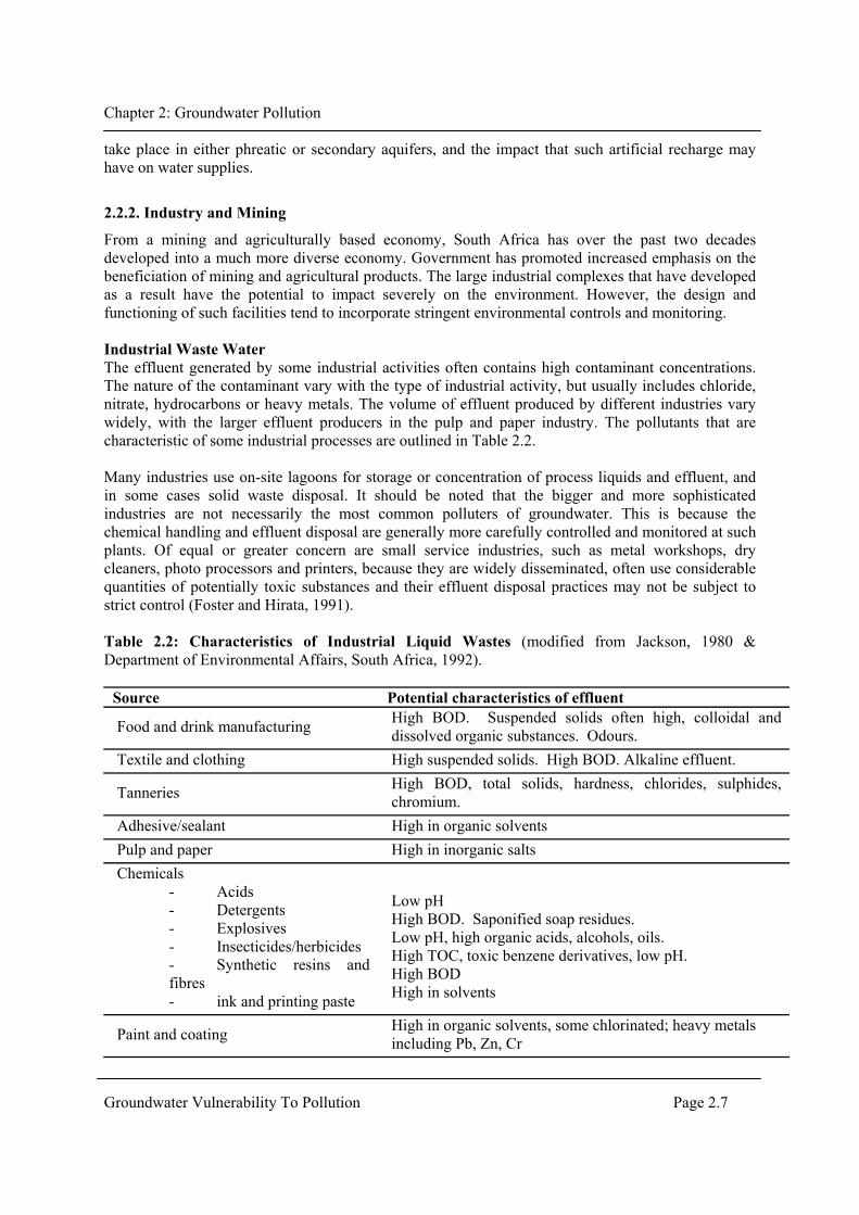
From a mining and agriculturally based economy, South Africa has over the past two decades developed into a much more diverse economy. Government has promoted increased emphasis on the beneficiation of mining and agricultural products. The large industrial complexes that have developed as a result have the potential to impact severely on the environment. However, the design and functioning of such facilities tend to incorporate stringent environmental controls and monitoring. Industrial Waste Water The effluent generated by some industrial activities often contains high contaminant concentrations. The nature of the contaminant vary with the type of industrial activity, but usually includes chloride, nitrate, hydrocarbons or heavy metals. The volume of effluent produced by different industries vary widely, with the larger effluent producers in the pulp and paper industry. The pollutants that are characteristic of some industrial processes are outlined in Table 2.2. Many industries use on-site lagoons for storage or concentration of process liquids and effluent, and in some cases solid waste disposal. It should be noted that the bigger and more sophisticated industries are not necessarily the most common polluters of groundwater. This is because the chemical handling and effluent disposal are generally more carefully controlled and monitored at such plants. Of equal or greater concern are small service industries, such as metal workshops, dry cleaners, photo processors and printers, because they are widely disseminated, often use considerable quantities of potentially toxic substances and their effluent disposal practices may not be subject to strict control (Foster and Hirata, 1991). Table 2.2: Characteristics of Industrial Liquid Wastes (modified from Jackson, 1980 & Department of Environmental Affairs, South Africa, 1992).
Source Potential characteristics of effluent
Food and drink manufacturing High BOD. Suspended solids often high, colloidal and dissolved organic substances. Odours.
Textile and clothing High suspended solids. High BOD. Alkaline effluent.
Tanneries High BOD, total solids, hardness, chlorides, sulphides, chromium.
Adhesive/sealant High in organic solvents Pulp and paper High in inorganic salts Chemicals
- Acids - Detergents - Explosives - Insecticides/herbicides - Synthetic resins and fibres - ink and printing paste
Low pH High BOD. Saponified soap residues. Low pH, high organic acids, alcohols, oils. High TOC, toxic benzene derivatives, low pH. High BOD High in solvents
Paint and coating High in organic solvents, some chlorinated; heavy metals including Pb, Zn, Cr

Chapter 2: Groundwater Pollution
Groundwater Vulnerability To Pollution Page 2.8
Petroleum and petrochemical - refining - process
High BOD, chloride, phenols, sulphur compounds. High BOD, suspended solids, chloride, variable pH.
Foundries Low pH. High suspended solids, phenols, oil.
Electronic manufacturing High in copper and other heavy metals, methanol, isopropanol, fluoro-and chlorofluoro-carbon
Plating and metal finishing Low pH. High content of toxic heavy metals, sometimes as sludges.
Engineering works High suspended solids, soluble cutting oils, trace heavy metals. Variable BOD, pH.
Wood treatment Creosote, pentachlorophenol, and some copper and chromium compounds
Thermal power
Increased water temperature. Slight increase in dissolved solids by evaporation of cooling wastes.
Leaking storage tanks, Pipeline leaks and Chemical transport Thousands of petrochemical filled storage tanks lie buried beneath filling stations. Many thousands of kilometres of pipelines exist and tanker trucks transport oil and chemical products over large distances. Leakages and spills from these sources are increasingly a threat to groundwater reserves. The study and rehabilitation of pollution from these sources are complicated by the fact that oils and petrol are only partly immiscible in water, resulting in the some compounds floating on water (LNAPL), while others sink (DNAPL). The effect that these compounds have on water resource quality is as a result of the solubility of some compounds in water. One of the more common groups of polluting compounds that result from such spills are the soluble aromatic hydrocarbons, known as the BTEX compounds. The drinking of organic-polluted groundwater may have serious health implications. However, it is difficult to establish which compounds are most toxic, while a serious lack of insight exists on the health effects related to the combined effect of several compounds, and on the epidemiology of populations consuming contaminated water. Organic contamination may cause cancer in humans and a host of other problems, including liver damage, impairment of cardiovascular function, depression of the nervous system, brain disorders, and various kinds of legions (Domenico and Schwartz, 1990). Atmospheric fallout The environmental impact of acid rain is widely recognised and documented (Knutsson, 1998). Acid deposition and related mineral fallout result from emissions generated by coal fired power stations, industrial process and vehicle exhausts. Such deposition may occur over large areas, with its impacts at times recorded hundreds of kilometres from the source of the emissions. Where acid rain occurs it results in diffuse groundwater pollution through the mobilization of heavy metals, especially copper and aluminium (Knutsson, 1998). Mine Tailings Many South African towns and cities have developed around large mining operations. South Africa remains largely a mining country, with the impacts of mining noticeable in most parts of the country. The residues of mining and milling operations are often stored on large dumps that are usually exposed to the environment. This often results in what is known as Acid Rock Drainage (ARD).

Chapter 2: Groundwater Pollution
Groundwater Vulnerability To Pollution Page 2.9
Acid Rock Drainage is caused by the exposure of sulphide minerals in rock to air and water, which results in the oxidation of sulphur in the mineral to a higher oxidation state The result is a low pH water, which reacts with bases in the country rock or residue deposits, dissolving salts and mobilizing heavy metals that may be contained in the host rock or residue. Iron pyrite (FeS2) is the most important source of Acid Rock Drainage that result in water pollution. Pyrite is most commonly found in association with coal and gold deposits. Acid drainage however will not occur if either the sulphide minerals are non-reactive, or the rock contains sufficient alkaline material to neutralize the acid. If alkaline material is available in the rock, pH may be raised as a result of neutralizing reactions as the drainage passes through the waste. The drainage that emerges from the waste has a pH that may vary from less that 1 to greater than 7. The longer the water is in contact with the sulphide mineral, the more chance the oxidation reaction has of proceeding and the more chance bacteria have of speeding it up and producing acid. The major environmental impact of ARD is often not realised until the poor quality water migrates away from the site of generation, and enters the receiving environment. Areas of Further Research A common practice by many mining and industrial operations is the treatment of waste water and mining discharge water through the use of artificial wetland systems. Some caution is advised as wetland systems have the potential to introduce polluted water to groundwater reserves. Though it is suspected that most natural wetland areas are at groundwater discharge points, no comprehensive study of the situation in the South African environment have been done.
2.2.3. Agriculture
Commercial Agriculture Commercial agriculture within and on the outskirts of urban areas is common to most South African cities. For instance, intense agriculture is practiced in the Philippi Horticultural Area, located on the southern edge of the Cape Town metropolitan area. The Philippi area is used mostly for the production of vegetables, with some pig and chicken farming and commercial milk farming. High levels of potassium and nitrogen values have been noted in groundwater samples taken from within the agricultural area (Bertam, 1989 and Conrad et al., 1999). The most likely sources of pollution result from feedlot wastes, pesticide/herbicide and fertilizer use, and groundwater deterioration as a result of excess irrigation. Subsistence Agriculture Household vegetable plots and gardening are features common to South African cities. Both these practices involve the application of fertilizers or manure, and pesticides and herbicides. Recorded instances of groundwater pollution from household gardening are generally the result of fertiliser application (As for exampled experienced in Perth, Australia - Gerritse et al., 1990). Feedlot wastes Feedlots tend to be located close to their major markets, and their source of feed. This has resulted in feedlots becoming a feature of the urban periphery. The solid waste generated in feedlots are often used to fertilize fodder crops or sold to other farmers. The effluent is usually stored temporarily in dams and then used to irrigate crops or applied to pasture (Conrad, et al., 1999). The improper disposal of animal waste from feedlots may result in surface or groundwater pollution. Some of the more important biological contaminants that may result include pathogenic bacteria, viruses and

Chapter 2: Groundwater Pollution
Groundwater Vulnerability To Pollution Page 2.10
parasites. Diseases that spread through the biological contamination of water include typhoid fever, cholera, polio and hepatitis. Pesticides and herbicides Studies are increasingly identifying instances of groundwater pollution by pesticide compounds. Increasingly international attention is also being focused not only on the presence of pesticide parent compounds, but also their metabolites. The most commonly detected metabolites are derived from aldicarb, atrazine, carbofuran, DCPA and endosulfan, and may be present in concentrations in excess of the parent compound (Chilton, et al., 2000). The greatest risk to groundwater supplies from pesticides are where (Chilton, et al., 2000):
• Aquifers are overlain by permeable soils and travel times to the water table is short. • The aquifer is of low porosity and consequently dilution is small • The pesticide is relatively mobile and stable.
Many aspects of the behaviour of pesticides in the soils zone and in groundwater remain poorly understood. So for instance, the extent to which pesticides persist in groundwater remain largely unknown. The occurrence, behaviour and significance of metabolites in groundwater systems also require further study. Pollution of groundwater by pesticides is a potentially serious and complex environmental problem (Conrad, et al., 1999) and its management requires a balance between the need for increased crop production and the requirement to maintain drinking water quality. Fertilisers Fertilisers applied to crops on intensively cultivated lands, and on domestic gardens in residential areas may impact on groundwater quality. Studies in Australia have found that up to 40% of an estimated 80 kg/ha (Gerritse et al., 1990) of nitrogen applied as fertilizers in residential areas can be leached to the water table. The highest nitrate input (outside agricultural land) is usually associated with golf courses and sports fields where large amounts of fertilizer are used. Water quality monitoring at such sites however is generally lacking, and the extent of their impact largely unknown. Irrigation Irrigation of cultivated lands often result in the build-up of salts in surface and groundwater. This salt build-up is largely the result dissolution of salts in weathered soils and its’ leaching to the saturated groundwater zone. The concentration of salt in return flow water is increased by the process of evaporation. Salts are further added to the system through the release of sodium salts after gypsum application and over-fertilisation. It is possible to control the amounts of salt released by considering the following (Kirchner, 1995):
• The amount of salts dissolved, the degree of concentration and the timing of the salt release can partly be governed by the irrigation method used, the time schedule and through the quantities applied.
• The choice made in selecting the area and timing of new land development. • Through the use of drains the concentration of salts through evaporation can be reduced.
Areas of Further Research This document lists those activities that pose a serious threat to groundwater resources. A lot of uncertainty however exists on the nature of those contaminants, what the individual critical chemicals

Chapter 2: Groundwater Pollution
Groundwater Vulnerability To Pollution Page 2.11
are in such pollution plumes and whether it is possible to prioritise contaminants and their associated sources which present the greatest threat to groundwater. From the case studies outlined in Conrad, et al. (1999), it is clear that many of the pollution impacts could be prevented through the application of appropriate management techniques. One of the outcomes of the study was the compilation of a non-technical booklet to inform farmers to recognise activities that may result in water quality deterioration. It is however, noted that South African researchers need to maintain contact with overseas researchers so that they may understand the latest trends in agricultural impact management. Nitrate pollution is one of the more common results of intense agriculture. During case studies by Conrad, et al. (1999) difficulty was experienced in identifying sources of nitrate pollution in groundwater. In such instances it was shown that the use of isotope techniques offer a means of determining the source of nitrogen pollution. Some work is however required on the most useful application of these techniques and their shortcomings. It is further recognised that a general lack of confidence exists among hydrogeologists in South Africa in the use of isotope techniques, and that analytical expertise is limited. The process of nitrate release from biomass decay caused by deep rip ploughing new areas for cultivation remains poorly understood, while the impact on groundwater quality remains unknown (Conrad, et al., 1999). Further, the general impact that elevated nitrogen levels has on the environment and human health also requires further study.
2.3. Pollution Attenuation
The impact that pollution discharges have on the groundwater environment is very dependent on the geological medium through which it moves. When passing through the soil and unsaturated zones, water interacts with the geological environment, where physical, chemical, and biological processes attenuate the pollutant concentrations. In general, the longer the period of contact between the contaminant and the soil/rock material, the more effective the decay and sorption process. This process is commonly referred to as natural attenuation. Sillilo (1997) cautions that it should not always be assumed that the unsaturated zone would attenuate and immobilise contaminants. Certain chemicals will be attenuated, while others will travel through rapidly to contaminate groundwater. The ability of the soil material is site specific, and will depend on the porous media characteristics at that location. The factors that will affect the fate of inorganic contaminants in the soils include the contaminant characteristics, the physical and chemical conditions in solution, the presence of other reactive species, the presence of complexing ligands, and the nature and surface area of solid particles and adsorbing surfaces The authors also noted that it is not possible to enforce a zero contamination policy. If the subsurface attenuation characteristics are known, and the extent of contamination that is tolerable, an assessment can be made with regard to areas with high and low attenuation potential. For planners and policy makers, such information is of crucial importance when linked to vulnerability mapping. A number of chemical processes are important in the attenuation of heavy metals in the subsurface, including complexation, dissolution/precipitation, adsorption, reduction/oxidation and hydrolysis. pH is the “primary variable” controlling these processes. For organic contaminants, the main factors and processes that may affect their fate in the subsurface are sorption, hydrolysis, oxidation/reduction,

Chapter 2: Groundwater Pollution
Groundwater Vulnerability To Pollution Page 2.12
volatization and biological degradation. The behaviour of organic molecules in soils is controlled by the chemical properties of the molecules and the surface. The soil properties that are important in contaminant attenuation include surface area, particle size, structure, mineralogy, organic and mineral coatings. Texture and surface are closely related, so that as particle size decreases, the surface area per unit mass increases. Elements are less mobile in soils that provide a large quantity of sorption sites. Oxides of Fe, Al, and Mn can provide chemisorption sites for cation and anion forms of elements. Layer silicate minerals provide exchange sites for cations, and a few chemisorption sites for both cations and anions. Soil organic matter can act as cation adsorption sites and is also involved in hydrophobic sorption of organic compounds. An overview of the processes that alter the characteristics of pollution plumes associated with waste disposal activities is presented below. Table 2.3 Probable effect of various processes on the mobility of constituents in subsurface waters contaminated by waste disposal (After Jackson, 1980) Physical Processes Dispersion - Causes dilution of wastes. The dispersive capacity of a porous or fractured medium is directly dependent on the groundwater velocity and the heterogeneity of the aquifer materials, and is inversely proportional to the porosity. Filtration - Favours reduction in amounts of substances associated with colloidal or larger-sized particles. Most effective in clay-rich materials. Least effective in gravels or fractured or cavernous rock. Gas movement - Where it can occur, favours aerobic breakdown of organic substances, and increased rates of decomposition. Constituents mobile under oxidized conditions will then predominate. Restriction of gas movement by impermeable, unsaturated materials or by saturated materials, can produce an anaerobic state, and reduced rates of organic decay. This will mobilize substances soluble under anaerobic conditions. Geochemical Processes Complexation and ionic strength - Complexes and ion pairs most often form by combination of ions including one or more multivalent ion and increase in amount with increased amounts of ions involved. Ionic strength is a measure of the total ionic species dissolved in groundwater. Both ionic strength and complexation increase the total amounts of species otherwise limited by processes such as oxidation, precipitation, or adsorption. Acid-base reactions - Most constituents increase in solubility and thus in mobility with decreasing pH. In organic-rich waters, the lower pH’s (4-6) are associated with high values of carbonic acid and often also of organic acids. These will be most abundant in moisture-saturated soils and rock. Oxidation-reduction - Many elements can exist in more than one oxidation state. Conditions will often be oxidized or only partially reduced in unsaturated soils and groundwater recharge areas, but will become reduced under saturated conditions when excess organic matter is present. Mobility depends on the element and pH involved: chromium is most mobile under oxidizing conditions, whereas iron and manganese are most mobile under those reduced conditions in which dissolved oxygen and H2S are absent. Precipitation-dissolution - The abundance of anions such as carbonate, phosphate, silicate, hydroxide, or sulfide may lead to precipitation especially of multivalent cations as insoluble compounds. Dilution, or a change in oxygen content where precipitation has involved oxidation or reduction, may return such constituents to solution. Adsorption-desorption - Ion exchange can withhold, usually temporarily, cations and to a lesser extent anions, on the surfaces of clays or other colloidal-sized materials. Amounts of adsorbed metal cations will increase with increasing pH. Molecular species may be weakly retained on colloidal-size materials by physical adsorption. The much stronger binding forces due to chemisorption result in the

Chapter 2: Groundwater Pollution
Groundwater Vulnerability To Pollution Page 2.13
formation of surface compounds involving metal ions and mineral grains. Adsorbed species may return to solution when more dilute moisture comes in contact with the colloidal material depending on the nature of the adsorption bond. Biochemical Processes Decay and respiration - Micro organisms can break down insoluble fats, carbohydrates, and proteins, and in so doing release their constituents as solutes or particulates to subsurface waters. Cell synthesis - N, C, S, and P, and some minor elements are required for growth of organisms, and can thus be retarded in their movement away from a waste disposal site.
2.4. Contaminant Source Mapping
The following is a summary mainly sourced from Foster and Hirata (1988). It is noted that while a range of human activities are likely to generate some contaminant load, it is found that just a few are responsible for major pollution events. If precise information in this respect can be obtained, a more accurate evaluation of groundwater pollution risk can be defined. Four semi-independent characteristics of the subsurface contaminant load need to be established for each polluting activity (Foster and Hirata, 1988):
1 The class of contaminants involved 2 The intensity of contamination 3 The mode of contaminant disposition to the subsurface 4 The duration of application of the contaminant load.
The class of contaminants involved in a given polluting activity can be defined by:
• Their tendency for in-situ degradation or transformation, as a result of natural bacteriological activity or chemical reaction
• Their tendency for retardation with respect to the rate of subsurface water flow. The intensity of contamination can be defined by:
• The relative concentration of each contaminant involved relative to some guideline value • The proportion of the local groundwater recharge experiencing contamination.
In the case of persistent mobile contaminants, the intensity of contamination is the predominant factor in the estimation of groundwater pollution risk. The mode of contaminant disposition to the subsurface can be defined by:
• The hydraulic load associated with the contaminant • The depth below surface at which the liquid effluent is discharged or the leaching of
contaminants occurs. The duration of application of contaminant load can be defined through consideration of:
• The probability that the contaminant will be discharged to the subsoil • The period during which the load is applied
Each of these components interact with a different component of the aquifer sensitivity, and this interaction determines the level of groundwater pollution risk.

Chapter 2: Groundwater Pollution
Groundwater Vulnerability To Pollution Page 2.14
2.4.1. Estimation of pollution load from urban residential areas
Most urban residential areas present a complex array of human activities potentially polluting to groundwater. The best way to evaluate the corresponding subsurface contaminant load is essentially to subdivide such areas according to predominant activity and wastewater arrangements. The principal concern in most areas is the contaminant load associated with unsewered sanitation units such as septic tanks, cesspits and latrines. Residential areas may also include service industries such as petrol filling stations, small automobile workshops, laundries and dry cleaners. From these, there is a great possibility of toxic compounds being present, notably benzene, chlorobenzenes, trichloroethylene, and tetrachloroethylene.
2.4.2. Estimation of pollution load of industrial activity
In order to characterize fully the contaminant load of an industrial activity, information on the quantity and quality of the effluent disposed of, or reaching the subsurface must be collected. The most difficult aspect is establishing what proportion of the total effluent will be directed, either accidentally, incidentally or deliberately to the subsurface. Many industries utilize on site lagoons for storage or concentration of process liquids and effluents, and in some cases solid waste disposal. Spillages and leakages from storage tanks and pipelines, together with contaminated drainage waters from industrial areas are also a common source of groundwater contamination. In Table 2.6, a summary of chemical characteristics and risk indices for common types of industrial activity is shown.
2.4.3. Estimation of contaminant load of lagoons
Lagoons are used widely for such processes as the storage, handling, evaporation, settlement and oxidation of effluents. These may be derived from municipal sewerage systems, or from industrial or mining activities. The great majority of lagoons have a natural base, to some degree impermeabilized. Nevertheless, leakage sometimes occur. To characterize the subsurface load generated by the presence of lagoons, it is necessary to consider two factors:
i. The quantity of liquid infiltrating from the lagoon ii. The quality and any changes in contaminant concentration that are likely to occur during
infiltration.
2.5. Discussion of Research Areas
The testing for specific organic pollutants is rarely done in South Africa. Sililo (1999) presents three case studies where although organic pollution was suspected, only the general parameters Dissolved Organic Carbon (DOC) and Chemical Oxygen Demand (COD) were tested for. The reason for this is often a lack of analytical facilities, the high cost of such analysis, and a low level of awareness among investigators. Investigators are rather inclined to test for those constituents for which strict guidelines and limits exist. A consequence of the use of general organic parameters is that the specific nature of the contaminant plume and its properties remain unknown. This limits understanding of the fate and transport of these contaminants. Remedial strategies that are proposed in case of organic pollution thus often do so without a full understanding of the problem and the ability to predict the results of their remedial actions.

Chapter 2: Groundwater Pollution
Groundwater Vulnerability To Pollution Page 2.15
Though it is recognised that the activities that pose a serious risk of groundwater pollution differ between industrialised and developing countries (Foster and Hirata, 1991), it must be appreciated that the structure of South African society is such that pollutants characteristic of different levels of industrialisation may impact local groundwater resources. The need therefore exists to develop an inventory of those pollutants associated with specific practices that may impact on groundwater. Cemeteries is not generally recognised as sources of groundwater pollution. The Australian experience has been that such sites do not have a large impact on groundwater resources. Special conditions exist in South African cities, which may lead to greater impact of such facilities (e.g. denser loading resulting from AIDS, Pheatic Cape Flats aquifer, poverty, etc.). The impact that stormwater discharges have on water quality is often not appreciated by urban planners. In many urban areas the recharge of stormwater runoff to aquifers is designed into stormwater systems. Though it is recognised that the reuse of water represents a means of adding to available water resources, the impacts and suitability of using storm-water discharge requires further study. Pesticide and herbicide use is wide spread in South Africa. Though studies have been done on the impact of many of these chemicals, these studies were conducted under conditions very different from those experienced in the South African environment. It would be worthwhile conducting a number of case studies on the impact that agricultural chemical use has in hard rock aquifer environments. Central to the management of water resources in the urban environment is the development of mechanisms to inform urban planners on the impacts that their land-use decisions could have on water resources. Some work is being done on ‘expert systems’. The development of an expect system for use by non-scientists, that considerers factors such as soil type, geology, and hydrogeology, all linked to a GIS system, could provide a partial solution.

Chapter 3: Groundwater Vulnerability
CHAPTER 3: GROUNDWATER VULNERABILITY
3.1. Introduction
In recognition of the importance of protecting groundwater resources from contamination, scientists and resource managers have sought to develop techniques for predicting which areas are more likely than others to become contaminated as a result of human activities at the land surface. The idea being that once identified, areas prone to contamination could be subjected to certain use restrictions or targeted for greater attention. The fact that some areas are more likely than others to become contaminated has led to the use of the terminology >groundwater vulnerability to pollution=. This concept means different things to different people (Box 1). Some authors view it as an intrinsic characteristic of the subsurface matrix. Others have associated vulnerability with the properties of individual contaminants or contaminant groups. Another group have associated vulnerability with a specific set of activities at the land surface.
3.2. Vulnerability assessment procedures
Groundwater vulnerability is an amorphous concept not a measurable property (NRC, 1993). It is a probability (ie., “the tendency or likelihood”) that contamination will occur, and thus must be inferred from surrogate information that is measurable. The vulnerability of groundwater to pollution depends upon
1. the time of travel of infiltrating water (and contaminants) 2. the relative quantity of contaminants that can reach the groundwater and 3. the contaminant attenuation capacity of the geological materials through which the
water and contaminants travel. The travel time, attenuation capacity and quantity of contaminants are a function of the following geological and hydrogeological attributes of any area:
1. The subsoils that overlie the groundwater 2. The type of recharge – whether point or diffuse 3. The thickness of the unsaturated zone through which the contaminant travels.
A number of methods for predicting groundwater vulnerability have been developed (Barber et al., 1993; NRC, 1993; Vrba and Zaporozec, 1994). Barber et al. (1993) subdivided the different approaches into empirical, deterministic, probabilistic and stochastic methods (Table 3.1). Empirical methods are based on combining maps of various physiographic attributes (e.g. geology, soils, depth to water table) of the region by assigning a numerical index or score to each attribute. These methods are based on commonly accepted experiences and professional judgement. In the simplest of these methods, all attributes are assigned equal weights. Empirical methods that attempt to be more quantitative assign different numerical scores and weights to the attributes. DRASTIC (Aller et al., 1987) is the best known example of these methods and has been applied in South Africa. Deterministic approaches use simplified analytical algorithms to arrive at a leaching potential index (LPI). The LPI is expressed in terms of pollutant velocity (V/R, where V is the average vadose zone percolation rate, and R is the retardation factor), depth to groundwater (Z) and decay constant (x) such that:
LPI =1000V/RxZ.
Groundwater Vulnerability To Pollution Page 3.1

Chapter 3: Groundwater Vulnerability
This method has not been used in this country for vulnerability assessments. Probabilistic, numerical/stochastic modelling require numerical solutions to mathematical equations that represent coupled processes governing contaminant transport. Stochastic methods use statistics to identify combinations of factors which determine vulnerability. These methods usually incorporate data on known areal contaminant distributions and provide characterizations of contaminant potential for the specific area from which data were drawn. These methods have not been applied in South Africa for vulnerability assessments. Table 3.1: Examples of different approaches to vulnerability assessment (Barber et al., 1993) Type of assessment
Scale of Application
Pollution Hazard
Example Identifier
Reference
Empirical
Local Local Regional & Local Regional Regional/National
UST -petroleum Landfill leachate Universal Universal Universal Aldicarb
MATRIX LeGrand DRASTIC GOD
Orgon DEQ, 1991 LeGrand, 1983 Aller et al., 1985 Foster, 1987 NRA, 1991 Lover et al., 1989
Deterministic
Local/regional Regional
Specific pollutants Pesticides
LPI
Bachmat & Collin, 1987 Meeks and Dean, 1990
Combined Empirical Deterministic
Regional Regional
Pesticides Pesticides
DRASTIC-CLMS DRASTIC-PRZM
Ehteshami et al., 1991 Banton & Villeneuve, 1989
Probabilistic
Regional
Pesticides
VULPEST
Villeneuve et al., 1990
Stochastic
Regional Regional possible National
Pesticides Universal/Pesticides
Discriminant Analysis weight of evidence models
Teso, 1989 New LWRRC project
Groundwater Vulnerability To Pollution Page 3.2

Chapter 3: Groundwater Vulnerability
Box 1: The many ways of defining groundwater vulnerability (After NRC, 1993). Foster (1987): Aquifer Pollution Vulnerability - Athe intrinsic characteristics which determine the sensitivity of various parts of an aquifer to being adversely affected by an imposed contaminant load.@ Groundwater Pollution Risk - Athe interaction between (a) the natural vulnerability of the aquifer, and (b) the pollution loading that is, or will be, applied on the subsurface environment as a result of human activity.@ U.S. General Accounting Office (1991): Hydrogeologic Vulnerability - Aa function of geologic factors such as soil texture and depth to groundwater.@ Total Vulnerability - Aa function of these hydrogeologic factors, as well as the pesticide use factors that influence the site=s susceptibility.@ Total Risk - AThis last approach is even broader, for it incorporates the size of the population at risk from potential pesticide contamination-that is, the number of people who obtain their drinking water from groundwater in the area. Pettyjohn et al (1991): Aquifer Vulnerability - AThe geology of the physical system determines vulnerability.@ Aquifer Sensitivity - AAquifer sensitivity is related to the potential for contamination. That is, aquifers that have a high degree of vulnerability and are in areas of high population density, are considered to be the most sensitive...@ U.S. Environmental Protection Agency (1993): Aquifer Sensitivity - AThe relative ease with which a contaminant (in this case a pesticide) applied on or near the land surface can migrate to the aquifer of interest. Aquifer sensitivity is a function of the intrinsic characteristics of the geologic materials of interest, any overlying saturated materials, and the overlying unsaturated zone. Sensitivity is not dependent on agronomic practices or pesticide characteristics.@ Groundwater Vulnerability - AThe relative ease with which a contaminant (in this case a pesticide) applied on or near the land surface can migrate to the aquifer of interest under a given set of agronomic management practices, pesticide characteristics and hydrogeologic sensitivity conditions.@ NRC (1993) : NRC (1993) defined groundwater vulnerability as >the tendency or likelihood for contaminants to reach a specified position in the groundwater system after introduction at some location above the uppermost aquifer=. But later in the book, the NRC also differentiated two types of vulnerability: specific vulnerability (referenced to a specific contaminant, contaminant class, or human activity) and intrinsic vulnerability, which does not consider the attributes and behaviour of specific contaminants.
3.3. Data requirements
Different methods require different levels of data. Generally, the more complex and detailed methods require more complex and detailed knowledge of the system being assessed. Simpler methods incorporate more approximations and are less precise. Table 3.2 shows details of spatial attributes used in different approaches to assess groundwater vulnerability to pollution. These attributes are discussed in more detail below in terms of data availability in South Africa.
Groundwater Vulnerability To Pollution Page 3.3

Chapter 3: Groundwater Vulnerability
Table 3.2: Details of spatial attributes used in a range of different approaches for assessment of vulnerability of groundwater to pollution (Barber et al., 1993) Special Attributes
Empirical
Deterministic
Stochastic/ Deterministic
Stochastic
Drastic (Aller er al 1987)
GOD Foster 1987
NRA (1990)
OREGON DEQ 1991
HOLLAND (Breeuwana & van Duijvenbooden 1987)
BELGIUM (DE Smedt 1987)
LPI (Meeks & Dean 1990)
DAKOTA (Lemme et al 1990)
VULPEST (Villeneuve et al 1990)
CALIFORNIA (Teao 1988)
AUSTRALIA (LWRRDC Project) proposed range of predictor variables (see text)
Meteorological Rainfaill Evapotranspiraton Recharge
X
X
X X
X
Land Surface Topography Slope
X
X
Soil Layer Soil Type Thickness Soil organic matter
X
X
X
X
X
Vadose Zone Media type Depth to groundwater Percolation rae Field capacity Class content Organic matter content Bulk density Cation exchange capacity
X X
X X
X
X X
X X X X X X
X X
X X X X
X X
Saturated Zone Aquifer type (media) Aquifer type (use) Hydraulic conductivity Hydraulic gradient
X
X
X X
X
X
X
Depth to groundwater Aquifer media
Pollutant specific Adsorption coefficient Retardaton coefficient Solubility Decay rate Octanol/water part coeffic
X X X X
X X
3.3.1. Meteorological
Meteorological data are required for the estimation of natural recharge. Net recharge can be used to estimate amount of water available for infiltration. Generally, the recharge rate will be negligible in arid areas and relatively higher in high rainfall areas. Methods for estimating recharge are described in a manual published by WRC (Bredenkamp, et al., 1995). The WRC is currently funding another project aimed at estimating recharge in the Northern Cape. Another aspect that requires attention is the effect of urbanisation on groundwater recharge. Urbanisation causes radical changes in groundwater recharge by modifying existing
Groundwater Vulnerability To Pollution Page 3.4

Chapter 3: Groundwater Vulnerability
mechanisms and introducing new ones (Foster et al. 1999, 2000). Table 3.3 shows some modifications that may cause changes in recharge rate to groundwater. Table 3.3: Influences on rates of groundwater recharge in urban areas (from Foster, 1999)
Urbanization Rates Effect on
infiltration Area
Time base
(A) Modification to natural system Surface impermeabilization and drainage: Storm water
soakaways* Mains pluvial
drainage Surface water
canalization
Increase Reduction Marginal reduction
Extensive Extensive Linear
Intermittent Intermittent to continuous Variable
Irrigation of amenity areas* Increase Restricted Seasonal (B) Introduction of water service network Local groundwater abstraction
Minimal
Extensive
Continuous
Imported mains water-supply leakage
Increase Extensive Continuous
On-site (unsewered) sanitation**
Major increase Extensive Continuous
Mains sewerage In urban areas* Downstream**
Some increase Major increase
Extensive Riparian areas
Continuous Continuous
3.3.2. Land surface
Land surface information such as topography and slope can be used to determine runoff and infiltration characteristics. The land surface information can be combined with soil profile information, geophysical data and well logs to produce a three dimensional representation of the subsurface hydrogeologic features. Topographic maps can be obtained from the Government Printing Works.
3.3.3. Soil layer
The potential of using soils information in vulnerability studies is explored in the next chapter
3.3.4. Vadose zone “ The cost of drilling and instrumentation, the slow rates of (some) water migration, and the remoteness of some areas that need to be studied all suggest that this topic of investigation will remain a fruitful one for many years, particularly for those with patience, imaginative thinking, and a fat budget” Davis, 1967 The unsaturated zone plays a major role in the transport and fate of contaminants from the surface to the water table. From Table 3.2 it can be seen that almost all methods consider thickness and properties of the unsaturated zone in their assessment procedure. The main unsaturated zone data requirements relate to the estimation of the infiltration rate. Methods for estimating the latter have been summarized in two WRC reports (Sililo et al. 1999; Van Schalkwyk and Vermaak, 2000). A complicating factor in the estimation of infiltration rate is
Groundwater Vulnerability To Pollution Page 3.5

Chapter 3: Groundwater Vulnerability
presence of preferential flow paths. These pathways can cause rapid transfer of water from the surface to aquifers (Sililo and Tellam, 2000). More field experiments are still required to determine the significance of preferential flow in different hydrogeological areas of South Africa. Van Schalkwyk and Vermaak (2000) conducted field experiments in Midrand and found that preferential flow did not significantly affect flow through the unsaturated zone. In terms of vulnerability assessments, there is need for improved predictive transport models through the unsaturated zone. Computer modelling offers an economic and effective way of making generalised predictions of contaminant fate and in addition, offers an opportunity to investigate the likely variability in behaviour in a much wider range of conditions than is possible experimentally. Unsaturated zone modelling has been discussed at length by Eigenhuis in Sililo et al (1999). A validated model (CHAIN 2D) used by Eigenhuis in his study can be obtained from the University of Stellenbosch. Research in the unsaturated zone should aim to develop a better understanding of the geologic framework of the subsurface and its effect on the storage and transmission of fluids. Research areas include • establishing simple, practical, and reliable methods for measuring in situ hydraulic
conductivity -establishing reliable transfer functions for estimating in situ hydraulic properties using available soil attribute data
• developing methods for accounting for preferential flow pathways in the unsaturated zone.
• develop methods for combining soils information and geologic information in vulnerability assessments.
• develop methods for merging data obtained at different spatial and temporal scales into a common scale for vulnerability assessment. It is unlikely that all data will be collected at the same spatial or temporal scale. Thus, it is very important to develop methods that permit data collected at one scale to be transformed to be transformed to a scale appropriate for a given assessment approach
3.3.5. Saturated zone
For vulnerability assessments, useful information includes aquifer type (media) and aquifer type (use). The latter is especially important for risk assessment. The Department of Water Affairs and Forestry is currently in the process of producing national 1:250 000-scale geohydrological map series
3.3.6. Pollutant specific information
Pollutant specific information is discussed in Chapter 2.
3.4. Scale of assessment
Vulnerability assessments are performed over areas ranging from the national level, through regional, urban municipal to field level. The degree of resolution required for any assessment depends upon the purpose for which it is intended. Table 3.4 shows the range of map scales at which different levels of assessment are appropriate. In South Africa, a vulnerability map has been produced at the national level (1:1 000 000). This map can be used for preliminary reconnaissance but cannot be used for site-specific assessments. Future efforts should therefore be directed at producing maps at smaller scales.
Groundwater Vulnerability To Pollution Page 3.6

Chapter 3: Groundwater Vulnerability
Table 3.4: Classification of groundwater vulnerability maps (After Vrba and Zaporozec, 1994)
TYPE OF MAP
SCALE
PURPOSE OF CONTENT
GRAPHIC PRESENTATION
GENERAL OVERVIEW SYNOPTICAL
1:500 000 or more
General planning, decision-making, and setting policies in groundwater protection on national or international level; educational purposes. Synthetical maps showing intrinsic vulnerability of groundwater, local details are lost.
Mostly manually compiled, two-dimensional maps or atlases with explanatory notes; computerized maps are not frequent yet.
SCHEMATIC
1:500 000 to 1:100 000
Regional planning, groundwater protection management and regulation, assessment of diffuse contamination problems. Most of local details are still lost, need to be followed by specific mapping
Manually compiled maps or two-or three-dimensional computerized maps or atlases.
OPERATIONAL
1:100 000 to 1:25 000
District land-use planning and design of groundwater protection programs. Analytical maps depicting vulnerability of groundwater in areal extent in relation to the specific contaminant travel time. Field survey desirable.
Computerized digital two- or three-dimensional maps or manually compiled maps, cross sections and diagrams increase their usability
SPECIFIC SPECIAL PURPOSE
1:25 000 or less
Single-purpose and site-specific maps for local or city planning and well protection. Express local or site specific groundwater vulnerability problems. Require set of representative data; site specific investigation is usually necessary.
Computerized digital two- or three-dimensional maps or diagrams (surface charts) and grid maps.
Groundwater Vulnerability To Pollution Page 3.7

Chapter 3: Groundwater Vulnerability
3.5. Recommended Approach
The following two types of assessment are recommended: 1 Intrinsic vulnerability assessment which focus on hydrogeologic settings and the
natural protection against contamination provided by physical characteristics, and 2 Specific vulnerability assessment which focus on the properties of specific
contaminants and their behaviour in the subsurface environment. Intrinsic assessments can be used to give an indication of the vulnerability of aquifers to persistent, mobile contaminants while specific assessments can be used for contaminants that will migrate at a rate much slower than the average wetting front. Table 3.6 shows data requirements for both intrinsic and specific assessments.
3.5.1. Intrinsic Vulnerability Assessment
• Aquifer
o Is the aquifer unconfined, semi-confined or confined? o If unconfined, what is the depth to groundwater?
• Recharge rate/mechanism o What is the dominant flow mechanism - preferential flow or non preferential
flow? o What is the infiltration rate?
3.5.2. Specific Vulnerability assessment
Note that if there is rapid transfer of water from the surface to groundwater, there might be no need for specific vulnerability assessments. Under such circumstances, intrinsic vulnerability assessments will suffice. In addition to the questions addressed under intrinsic assessment above, the following would also be required for specific vulnerability assessments:
• Pollution source: o Identify potential contaminants and their transport and fate characteristics. o Nature of loading (contaminant loading risk) - is it solid waste or liquid
waste? o Level of deposition: surface or below soil zone?
• Unsaturated zone properties o Thickness of soil cover/unsaturated zone o clay content, organic matter content, sesquioxide content, lime content
3.6. Future
1. As indicated before, DRASTIC has been applied in South Africa. However its validity has not been tested. There is therefore need to determine under what circumstances DRASTIC can be applied.
2. Protocols for producing specific vulnerability maps must be developed and tested. This is especially important for those contaminants which pose the greatest risk, e.g. petrochemicals, microbes and nitate.
Groundwater Vulnerability To Pollution Page 3.8

Chapter 3: Groundwater Vulnerability
Table 3.5: Intrinsic and specific attributes of groundwater vulnerability and their parameters (After Vrba and Zaporozec, 1994)
INTRINSIC (NATURAL) Primary Importance
ATTRIBUTE PARAMETERS
Soil
Unsaturated (vadose) zone
Aquifer (saturated zone)
Recharge
PRINCIPAL
Texture Structure Thickness Content of soil organic matter Clay mineral content Permeability
Thickness (related to groundwater table) Lithology (with regard to consolidation andstratification of rock)
Thickness
Travel time water
Lithology (with regard to consolidation andstratification of rock)
Annual precipitation
Effective porosity Hydraulic conductivity Groundwater flow direction Age and residence time of ground eater
Net annual recharge rate
SUPPLEMENTAL
Cation exchange capacity Reduction and sorption capacity Carbonate +Bulk density +Full soil water capacity +Water uptake by plant roots +Nitrogen transfer reactions
Weathering rates Permeability
Hydraulic inaccessibility Storage capacity Transmissivity
Evaporation Evapotranspiration Air temperature
Continued……….
Groundwater Vulnerability To Pollution Page 3.9

Chapter 3: Groundwater Vulnerability
INTRINSIC (NATURAL) Primary Importance
ATTRIBUTE PARAMETERS
Topography
Underlying geological unit of aquifer
Contact with surface and sea water
SPECIFIC
PRINCIPAL
Slope variability land surface
Permeability Structure and tectonics Potential recharge/ discharge
Gaining/loosing stream Evaluation of potential bank infiltration Interface of salt/fresh water in coastal areas
Land use Natural: forest, meadow, non- farm land Man-made: farm land, land under industrial activities , rural or urban settlements Population density Travel time of contaminants in the unsaturated zone ++Attenuation capacity of the soil, unsaturated zone, and aquifer in relation to specific contaminants.
SUPPLEMENTAL
Vegetative cover
In case of confined aquifer the same parameters apply for the underlying unit of aquifer
Residence time of contaminants in aquifer Transport characteristic of contaminants - distribution coefficient (Kd) values, persistence (half-life) Artificial recharge Irrigation Drainage
Groundwater Vulnerability To Pollution Page 3.10

Chapter 4: Soil Information in Vulnerability Assessment
CHAPTER 4: SOIL INFORMATION IN VULNERABILITY ASSESSMENT
4.1. Introduction
During infiltration through soils, many contaminants are naturally attenuated. An evaluation of the protective properties of soils is, therefore, one of the most important tasks for vulnerability assessments (Andersen and Gosk, 1987; Breeuwsma and van Duijvenbooden, 1987; Lemme et al., 1991). In South Africa, the importance of soils information in vulnerability studies has been recognized. A WRC funded project was completed in 1999, in which one of the main objectives was to “determine the relationship between soil physical and chemical properties (e.g. soil type, soil thickness and other attributes) and its contaminant attenuation capacity”. Although at the end of the project some of the aspects that were envisaged were not accomplished, the research showed great potential in terms of using soils information in vulnerability assessment. For example, Sililo et al. (2001) demonstrated that qualitative contaminant attenuation maps can be derived from land type data. Such maps could be used for land-use planning purposes to give a broad overview of favourable and unfavourable areas for certain human activities. In this chapter, a framework is proposed for further research that will provide a basis for incorporating information about soils into the assessment of groundwater vulnerability to contamination. The possibility of drafting a preliminary soil classification based on current knowledge is demonstrated, emphasising the important inferences (including climatic and hydrological ones) which can be drawn from pedogenic information inherent in the current, general purpose, classification system. There is considerable scepticism still evident in the recent literature about the practical value of mathematical models in making land-use planning decisions. The scepticism is justified because there are still major uncertainties especially associated with preferential flow paths and how these influence recharge. Also, in the local context, our knowledge of Quaternary geology and of soils is insufficiently detailed for regional planning purposes, which means that the application of a vulnerability classification system is only likely to be useful when it is site-specific and preceded by intensive geotechnical investigation.
4.2 Assumptions
Our proposed strategy is based on a set of assumptions which may be controversial but which will considerably simplify the task of providing land users and developers with a workable system for assessing risk. These assumptions are that:
1 Most rock formations, as well as some relatively unconsolidated materials, are fractured sufficiently for preferential flow to dominate the recharge process.
2 This preferential flow is rapid enough for water-rock interaction to be negligible. 3 Water-soil interaction will therefore have a dominant influence on the composition
(including contamination) of the groundwater. Thus, if the soil is chemically inert the groundwater will have a composition approaching that of rainwater. Otherwise, it will have a chemical signature related to that of the soil solution or of pore water in the vadose zone.
Obviously from a hydrogeological perspective these assumptions represent a gross oversimplification but, provided as much information as possible about the regolith and vadose zone is included in what we define as “soil”, it should not fall too short of providing a useful first approximation for assessing aquifer vulnerability.
Groundwater Vulnerability To Pollution Page 4.1
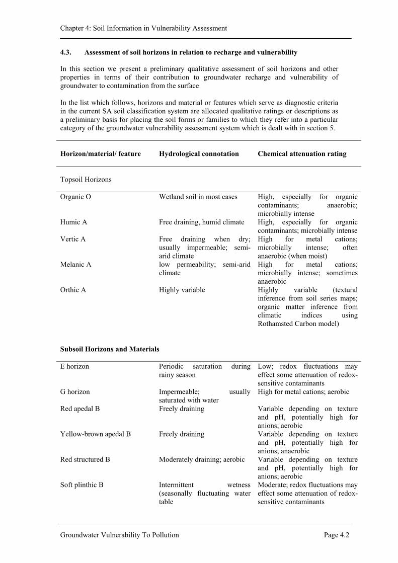
Chapter 4: Soil Information in Vulnerability Assessment
4.3. Assessment of soil horizons in relation to recharge and vulnerability
In this section we present a preliminary qualitative assessment of soil horizons and other properties in terms of their contribution to groundwater recharge and vulnerability of groundwater to contamination from the surface In the list which follows, horizons and material or features which serve as diagnostic criteria in the current SA soil classification system are allocated qualitative ratings or descriptions as a preliminary basis for placing the soil forms or families to which they refer into a particular category of the groundwater vulnerability assessment system which is dealt with in section 5. Horizon/material/ feature
Hydrological connotation
Chemical attenuation rating
Topsoil Horizons Organic O Wetland soil in most cases High, especially for organic
contaminants; anaerobic; microbially intense
Humic A Free draining, humid climate High, especially for organic contaminants; microbially intense
Vertic A Free draining when dry; usually impermeable; semi-arid climate
High for metal cations; microbially intense; often anaerobic (when moist)
Melanic A low permeability; semi-arid climate
High for metal cations; microbially intense; sometimes anaerobic
Orthic A Highly variable Highly variable (textural inference from soil series maps; organic matter inference from climatic indices using Rothamsted Carbon model)
Subsoil Horizons and Materials E horizon Periodic saturation during
rainy season Low; redox fluctuations may effect some attenuation of redox-sensitive contaminants
G horizon Impermeable; usually saturated with water
High for metal cations; aerobic
Red apedal B Freely draining Variable depending on texture and pH, potentially high for anions; aerobic
Yellow-brown apedal B Freely draining Variable depending on texture and pH, potentially high for anions; anaerobic
Red structured B Moderately draining; aerobic Variable depending on texture and pH, potentially high for anions; aerobic
Soft plinthic B Intermittent wetness (seasonally fluctuating water table
Moderate; redox fluctuations may effect some attenuation of redox-sensitive contaminants
Groundwater Vulnerability To Pollution Page 4.2

Chapter 4: Soil Information in Vulnerability Assessment
Horizon/material/ feature Hydrological connotation Chemical attenuation rating Hard plinthic B Intermittent wetness; low
permeability Moderate; redox fluctuations may effect some attenuation of redox-sensitive contaminants
Prismacutanic B Low permeability (clay pan horizon); preferential, interpedal flow; sub-humid/semi-arid climate
Potentially high for metal cations
Pedocutanic B Low permeability (clay pan horizon); preferential, interpedal flow; sub-humid/semi-arid climate
Potentially high for metal cations
Lithocutanic B Highly variable depending on saprolite condition; preferential flow likely
Variable
Neocutanic B Moderately well drained; variable
Moderate
Neocarbonate B Moderated drainage; semi-arid/ arid climate
Moderate
Podzol B Usually well drained but may sometimes signify water table; high winter rainfall
Low because of texture but organo-metal complexation may help attenuate trace metals
Regic sand Freely draining when dry; sometimes seasonally wet
Extremely low
Stratified alluvium Variable; floodplain soils Variable Placic pan Barrier to water movement
unless fractured Low due to small interface for attenuation
Dorbank Barrier to water movement unless fractured; arid climate
Low due to small interface for attenuation
Saprolite Variable depending on degree of weathering; preferential flow more likely
Variable
Soft carbonate horizon Permeable; arid climate Very high for metals Hardpan carbonate horizon Low permeability with
preferential flow; arid climate
Very high for metals but smaller interface for attenuation
Unconsolidated material without signs of wetness
Usually permeable depending on texture
Variable
Unconsolidated material with signs of wetness
Variable but drainage restriction indicated
Redox-related attenuation possible
Unspecified material with signs of wetness
Drainage restriction Redox-related attenuation possible
Hard rock Drainage restriction; preferential flow likely
Low
Anthropogenic soil deposit Variable Variable Features diagnostic for soil families Fibrous and humified organic material
More fibrous condition probably more permeable
More fibrous state suggests lower capacity for biodegradation
Thin and thick A horizons Greater water holding capacity for thick horizons if overlying saprolite
Thicker horizons provide longer exposure to biodegradative processes
Groundwater Vulnerability To Pollution Page 4.3

Chapter 4: Soil Information in Vulnerability Assessment
Dark and light coloured A horizons overlying the E horizon in Fernwood form
Dark horizons usually associated with wetter landscape position (eg. wetland)
More biodegradation and adsorption in darker horizons
Bleached orthic A horizon Permeable Low (bleaching implies high solute mobility)
Dark, red and other colours found in vertic A horizons and in the pedocutanic B horizons which occur beneath melanic A horizons
The redder, the more permeable, and vice versa
Moderate to high
Horizon/material/ feature
Hydrological connotation
Chemical attenuation rating
Presence and absence of lamellae in the Fernwood form
Clay lamellae partially arrest drainage in otherwise permeable sands
Lamellae will confer some attenuation in otherwise inert sands
Dystrophic Strong leaching (humid climate)
Variable, but low pH favours anion sorption
Mesotrophic Intermediate Variable Eutrophic Weak leaching (arid semi-arid
climate) Variable, but high pH favours cation sorption
Non-red and red colours in B horizons, stratified alluvium and regic sand
The redder the more permeable and vice versa
Variable (redder colours favour more anion sorption and signify more aerobic conditions)
Luvic B horizon Permeability lower than overlying horizon
Moderate to high; higher than overlying horizon
Subangular/fine angular and medium/coarse angular structure in pedocutanic B and red structured B horizons
None None
Continuous black cutans in prismatic B horizons
More humid climate than usual (semi-arid/sub-humid)
None
Ortstein hardening of podzol B horizons
Low permeability (often associated with water table; winter rainfall)
Less than normal podzol B
Hard and not hard lithocutanic B horizons and saprolite
Permeability varies accordingly
Softer consistence implies more porosity and greater interface for attenuation
Signs of wetness Poor drainage Redox attenuation of some contaminants
Calcareous horizons and layers
Arid/semi-arid climate High for metal cations
Podzolic character beneath a diagnostic yellow-brown apedal B horizon
Winter rainfall climate (normally)
Some additional trace metal retention capacity
Friable and firm C horizons Lower permeability of greater preferential flow for firm consistence
More interfacial contact with contaminants in friable C horizon
Material underlying organic O horizons
G horizon confirms wetness associated with wetland environment
None (groundwater already accessed)
Groundwater Vulnerability To Pollution Page 4.4

Chapter 4: Soil Information in Vulnerability Assessment
4.5 Groundwater vulnerability classification of South African soil forms
In this provisional system, two criteria have been employed: 1. hydraulic attenuation and 2. chemical attenuation. These are explained in Tables 4.1 and 4.2 and the ensuing discussion. Table 4.1: Hydraulic attenuation: soil contribution to intensity of groundwater recharge*
Class Attenuation capacity and pedogenic inference
1 Maximal hydraulic attenuation: bare sheet rock; heavy crusting clays; steep slopes; extreme aridity; minimal vegetation cover; shallow dorbank or calcrete horizons
2 Most calcareous and eutrophic clay soils; duplex and margalitic soils; lithocutanic soils with steeper relief
3 Intermediate: mostly loamy, thicker eutrophic or mesotrophic soil profiles on gentler relief
4 Dystrophic or mesotrophic loams and ferrallitic clays and loams on gentle relief
5 Minimal hydraulic attenuation: extreme water surplus sustained for significant periods; sandy soil texture; absence of luvic or clay pan features in soil profile + vadose zone; regic sands of humid climates on level topography
* - Rainfall intensity less Runoff intensity less Evaporation intensity = Water available for deep drainage; then Recharge intensity (mm/day) = water available for deep drainage less Water storage capacity of soil profile. The soil makes two contributions: (i) as a barrier, forcing increased runoff and (ii) as a capillary reservoir, allowing water to evaporate before it can drain. A critical factor in determining classes in Table 4.1, which is not normally incorporated into hydrological models (e.g. ACRU), is the additional pedogenic inference made possible by the relationship between key soil chemical properties and climatic indices. As examples, degree of leaching correlates with sum of exchangeable cations (Donkin & Fey, 1993); an arid/semi-arid climate, hence very low recharge, is indicated by presence of secondary carbonates; etc. Placement of soil into one of the five relative risk classes does not require the intensity of recharge to be calculated as described in Table 4.1. The rating may be arrived at, as a first approximation, by pedogenic inference. Water balance calculations will nevertheless be essential as the need arises for greater refinement.
Groundwater Vulnerability To Pollution Page 4.5

Chapter 4: Soil Information in Vulnerability Assessment
Table 4.2: Soil chemical contribution to contaminant attenuation
Class Attenuation capacity and pedogenic inference
A.
Cationic contaminants ( inorganic and polar organic)
1. Maximal attenuation: Thick, clayey profiles especially margalitic soils; strongly calcareous clays; eutrophic peats
2. 3. Intermediate: 4. 5. Minimal attenua
B. Anionic contam
1. Maximal attenua2. 3. Intermediate: 4. 5. Minimal attenua
C. Organic contam
1. Maximal attenua2. 3. Intermediate: 4. 5. Minimal attenua
all other soils (based on criteria in section 4 and research data)
Application of the two critthree approaches described (i) Combination of the two r Step 1. Identify th
maximal, 5Step 2. Select the hStep 3. Sum these with a max 10 would imStep 4. Average th obtain an o (ii) Selection of the most cri Select hydraulic and chemcategory is the smallest.
(e.g. (i) a humic fefor chemical attenuFor all 3 categoriesweighting falls awa
Groundwater Vulnerability
}
tion: Dystrophic sands low in humusinants ( inorganic and polar organic)
tion: Deep, dystrophic, ferrallic clays
t
i
t
t
eb
a
e yti
ev
t
i
ra y
T
}
ion: Eutrophic sandsnants (non-polar)
ion: Deep humic clays and peats
}ion: Pu
ria (hyelow:
tings.
conta= minidraul
wo ramum ply un risk serall
ical of
cal sc
rallitiction, sof co (the o
o Pol
all other soils (based on criteria in section 4 and research data)
all other soils (based on criteria in section 4 and research data)
re sands low in humus
draulic and chemical) is envisaged in terms of one of the
minant and select the chemical attenuation rating (1 = mal) ic attenuation rating (1 = maximal, 5 = minimal) tings and multiply by 10 to obtain a percentage risk score risk of 100 (minimum risk of 20 is appropriate since 0 or warranted optimism).
core for each of the three contaminant categories to rating of the soil (report as whole number percent).
the two ratings.
ores as above. The soil is then classified into whichever
clay (Inanda form) scores 4 on hydraulic attenuation but cores 3 for metal cations, 1 for anions and 2 for organics.
ntaminant, the chemical score is applied and the hydraulic verall rating averages at 2).
lution Page 4.6
Chapter 4: Soil Information in Vulnerability Assessment
(ii) a duplex, calcareous clay soil (Estcourt form) on moderately steep slopes in a semi-arid area, scores a 1 for hydraulic attenuation. This score therefore prevails despite a chemical rating of 1 for cations, 4 for anions and 4 for organics.)
This second approach presupposes that each risk factor (physical and chemical) represents a “safety net” whereby the factor with the lowest risk cancels the higher risk associated with the other. The assumption required is that the relative risk scores in each case represent equivalent absolute risk. (iii) A hybrid approach, based on the first two. A third approach might be to devise an arithmetic middle ground between the first two approaches, i.e. apply the first approach then modify the score by averaging it with that obtained using the second approach. This would build a safety net weighting into the final score. The proposed classification system is likely to be most useful for site-specific investigations and planning decisions, where the soil type has been accurately identified. For mapping purposes the classification will yield results which are no better than the quality and detail of existing soil maps. For South Africa as a whole this detail is very poor, consisting mainly of land type maps at 1: 250 000 scale in which each land type is identified in terms of a certain proportion of a number of (sometimes highly diverse) soil types associated with different terrain morphological units within a region of relatively homogeneous climate and topography. Regional planning decisions will be commensurately fraught with a high level of uncertainty. Some exceptions, however, might be areas dominated by sandy soils (e.g. Cape Flats or the Zululand coastal plain) or by red and black clays (e.g. the Springbok Flats). Another important exception might prove to be the case of non-polar organic contaminants (at least for low level, non-point source contaminants, such as pesticides). In this case the organic matter content of the soil is the critical determinant of attenuation capacity, coupled with hydrological (water-balance) calculations. Although neither of these determinants is catered for in a satisfactorily quantitative way by the soil classification system, both may be arrived at by calculation from climatic data. In particular, the Rothamsted Carbon Model may provide a means of mapping soil humus content based on daily or monthly temperature and rainfall data, these already having been employed to generate climatic maps of the country which are much more reliable, in terms of detail, than 1: 250 000 land maps.
4.6. Proposed research strategy
Five facets are recommended: 1. An assessment of the pollutant attenuation capacity of soil horizons and other regolith
materials and a description of the diagnostic value of key morphological and chemical properties of soils which automatically convey information on contaminant transport potential even if only qualitative or relative.
2. A special purpose classification of SA soils based on the binomial system with attenuation capacity ratings as a basis for higher order groupings.
3. Incorporation of hydrological inferences into the soil classification by identifying chemical affinities between groundwater and the overlying soil/regolith and their relationship to recharge characteristics.
4. A GIS treatment of existing land type maps to produce a spatial-statistical assessment of soil contribution to aquifer vulnerability.
5. A special short course on soil properties relevant to groundwater contamination. The first three facets of the research strategy have been briefly addressed in the ensuing sections of this report. The purpose of presenting these preliminary outlines of a classification
Groundwater Vulnerability To Pollution Page 4.7

Chapter 4: Soil Information in Vulnerability Assessment
system for soils and soil materials or horizons is to give the reader an insight of what can be done using available soil information. The fourth and fifth facets are self-explanatory and will each require separate consideration as potential research projects, which will become viable once sufficient progress have been made with the first facets.
Groundwater Vulnerability To Pollution Page 4.8

Chapter 5: Research Strategy
CHAPTER 5: RESEARCH STRATEGY
5.1 Introduction
As indicated in Chapter 1, the WRC had recommended that before a research strategy is finalized, all major role players should be consulted and consensus obtained. To achieve this, a number of visits were undertaken to a number of groundwater practitioners and institutions to discuss research needs in the field of groundwater protection. A workshop was also held with a group of experts to discuss proposed research areas. Table 5.1 summarizes issues which different experts felt should be included in the research agenda. Table 5.1: Recommended areas of research by different experts. Institution Recommended areas of research DWAF – Geohydrology (Eberhard Braune)
urgent need to develop protocols for assessing groundwater pollution impacts, with the ultimate aim of incorporating these in policy documents need to relate strategy to land-use planning (DWAF source based strategies), especially vulnerability maps at smaller scales
DWAF (Water Quality) Manda Hinsch
need to develop procedures for assessing pollution impacts from informal settlements. Need for guidelines for assessing groundwater contamination from underground fuel tanks.
DWAF (Regional office –Kwazulu Natal) Georgina King
- interest in management approaches relating land-use mapping to groundwater vulnerability assessment.
Consultant Roger Parsons
need to develop assessment procedures that incorporate contaminant loading (source) and contaminant attenuation (pathway) need to document case studies on the effects of various sources of pollution need to develop minimum requirements for different sources of pollution
Consultant Ritchie Morris
-stressed need for risk assessment approach -need for standardized site characterization and monitoring procedures -need for standards of acceptable contaminant levels
CSIR Researcher Gideon Tredoux
suggested a two-tier approach: firstly a regional overview of the country and from there identify where we want to go concentrate on site-specific aspects
ISCW Carl Stein
need for land use mapping need to identify potential groundwater contaminants
University of Pretoria A van Schalkwyk
need for regional overview from geological maps and recognise what we can get from these maps need for further research in preferential flow
DWAF (Reional office – Western Cape) -Mike Smart
need for tools to use at a local scale. What risks can we expect in different environment simple table giving flow rates for different rock types
Groundwater Vulnerability To Pollution Page 5.1

Chapter 5: Research Strategy
5.2 Research Agenda
The research agenda described in this section will form a major part of WRC’s Programme on Groundwater Protection. In defining potential projects below, the following were taken into account:
1 data requirements for assessing groundwater vulnerability to pollution 2 comments from different role players (Table 5.1) 3 DWAFs source-based strategies.
We believe that the projects outlined below, if conducted, will contribute significantly to the implementation of DWAF’s groundwater quality management strategy. The research areas are thus discussed in terms of the following programmes DWAF intends to initiate: 1 National information programme and Aquifer management programme 2. Aquifer classification programme For further details on any of the proposed projects, readers are encouraged to refer to preceding chapters in this report.
5.2.1. National Information programme and Aquifer management Programme “The department of Water Affairs and Forestry will establish and maintain a national information system for groundwater in South Africa … The national information system will provide a basis for: establishing and tracking trends in groundwater quality; prediction of macro impacts; and land-use planning guidance” DWAF, 2000 “ Aquifer management plans will be required for designated aquifers. These strategies will serve to achieve among other things, the following objectives: identify and initiate protection of groundwater quality from degradation; facilitate collection and management of groundwater quality data… ” DWAF, 2000. In terms of DWAF’s agenda, the proposed projects outlined below will contribute to “establishing an understanding of the relationship between polluting activities (sources) and quality effects in the groundwater, i.e. understanding the origin of pollutants, the pathways which these pollutants could follow into the environment and the ultimate fate of these pollutants”. Last bullet of Section 3.4, DWAF, 2000. National groundwater contamination inventory: to document, with existing data, the extent, spatial distribution, propagation and types of contaminants and their associated sources which present the greatest threat to groundwater. There is urgent need to identify and prioritise the type of contaminants and their associated sources which present the greatest threat to groundwater in South Africa. Once identified, such contaminants (and sources) must be given priority in future research. Detection and Evaluation of groundwater contamination caused by organic chemicals in urban areas of South Africa. Individual organic contaminants are rarely determined during groundwater pollution investigations. Thus the extent of the problem is not known. Organic contaminants may cause harmful effects at very low concentrations. There is urgent need to assess the extent of the problem and ultimately develop guidelines for detection and evaluation of contamination caused by organic chemicals. There is currently lack of widely available information on organic contaminants and analytical facilities in the country. Determine the contaminant attenuation potential of different hydrogeological environments for contaminants of concern. For example, for microbiological contaminants, determine their survival times in the subsurface.
Groundwater Vulnerability To Pollution Page 5.2

Chapter 5: Research Strategy
Develop guidelines for site characterization and monitoring at contaminated sites. There is need to develop standard guidelines (minimum requirements) for site characterization and monitoring during pollution investigations.
5.2.2. Aquifer classification programme
Ideally, this section should be called “aquifer vulnerability assessment programme”. However, the latter does not appear in DWAFs programmes and has been included with the aquifer classification programme. “South African groundwater protection will be based on a differentiated approach, which distinguishes between aquifers on the basis of importance and vulnerability” DWAF, 2000. Thus there will be need to “establish an understanding of the importance and vulnerability to pollution of the country’s groundwater resources”. Bullet 4, Section 3.4, DWAF, 2000. The proposed projects described below will help improve our vulnerability assessments. Develop improved methods for vulnerability assessments, and ultimately develop guidelines for conducting vulnerability assessments. There is need to determine which processes are the most important to incorporate into vulnerability assessments in different hydrogeological environments and at different spatial scales. The validity of using different methods, including DRASTIC which has been applied in South Africa, must be tested Develop methods for using available soils information in vulnerability assessments. There is need for assessment of the pollutant attenuation capacity of soil horizons and other regolith materials and a description of the diagnostic value of key morphological and chemical properties of soils which automatically convey information on contaminant transport potential. There is also need for a special purpose classification of SA soils based on the binomial system with attenuation capacity ratings as a basis for higher order groupings. Another important aspect is incorporation of hydrological inferences into the soil classification by identifying chemical affinities between groundwater and the overlying soil/regolith and their relationship to recharge characteristics. A special short course on soil properties relevant to groundwater contamination would be advantageous. Develop methods for combining soils information and geologic information in vulnerability assessments. There is need to integrate soil and geologic information in vulnerability assessments. Both are important and need to be incorporated in assessment approaches. Develop methods for merging data obtained at different spatial and temporal scales into a common scale for vulnerability assessment. It is unlikely that all data will be collected at the same spatial or temporal scale. It is thus very important to develop methods that permit data collected at one scale to be transformed to a scale appropriate for a given assessment approach Develop improved approaches to quantifying groundwater recharge in urban catchments. Urbanization causes radical changes in groundwater recharge by modifying existing mechanisms and introducing new ones. An understanding of these mechanisms is crucial in groundwater vulnerability assessments in urban areas. Establishing simple, practical, and reliable methods for measuring (or estimating) in situ hydraulic conductivity of the unsaturated zone. This information is of primary importance in determining flow of water (and contaminants) in the subsurface.
Groundwater Vulnerability To Pollution Page 5.3

Chapter 5: Research Strategy
Developing methods for accounting for preferential flow pathways in the unsaturated zone. Routes of transport that circumvent the porous media have a profound effect on flow and are difficult to quantify. It is important to identify areas where preferential flow will be dominant, and develop methods for quantifying the effects of this mechanism in such areas.
5.3 Implementation
The projects identified here are critical to establishing an improved understanding of the relationship between polluting activities (sources) and quality effects in the groundwater, i.e. understanding the origin of pollutants, the pathways which these pollutants could follow into the environment and the ultimate fate of these pollutants. We therefore recommend that researchers should be encouraged to put in proposals on any of these projects
Groundwater Vulnerability To Pollution Page 5.4

Chapter 6: Discussion and Conclusions
CHAPTER 6: DISCUSSION AND CONCLUSIONS
To recap, the main aim of this project was to formulate a research strategy that the WRC would use as a basis for funding future research in this field. Specific objectives as listed in Chapter 1 were: to summarize current state of the art methodologies for determining groundwater pollution impacts of anthropogenic activities. to summarize current approaches used in South Africa and identify any limitations. to define a suitable methodology and consequently to formulate a research strategy. to hold a workshop to obtain consensus from the role players on the suggested methodology and research strategy. Objective 1: to summarize current state of the art methodologies for determining groundwater pollution impacts of anthropogenic activities. Objective 1 relates to groundwater vulnerability assessment with emphasis on assessment techniques. The vulnerability assessment approach discussed here requires information on the source of contaminants. Aspects relating to the latter are discussed in Chapter 2. In Chapter 3, a review of vulnerability assessment approaches is given. Objective 2: to summarize current approaches used in South Africa and identify any limitations. In both Chapters 2 and 3, an assessment is made as to whether the techniques summarized have been applied to South Africa. It is clear that more research is still required to understand the source aspect. The research gaps are identified. From the review on vulnerability assessments, it is clear that most of the methods that have been reported in the literature have not been applied in South Africa. Research areas to improve our understanding of the vulnerability approach are given. Because of the importance of soils information in vulnerability assessments, this topic was given considerable attention. In Chapter 5, a framework is proposed for further research that will provide a basis for incorporating available soils information into the assessment of groundwater vulnerability to contamination. The possibility of drafting a preliminary soil classification based on current knowledge is demonstrated, emphasising the important inferences which can be drawn from pedogenic information inherent in the current, general purpose, classification system. Objective 3: To define a suitable methodology and consequently to formulate a research strategy. No single methodology is suitable on its own. We recommend a combination of Intrinsic vulnerability assessment which focus on hydrogeologic settings and the natural protection against contamination provided by physical characteristics, and Specific vulnerability assessment which focus on the properties of specific contaminants and their behaviour in the subsurface environment. Intrinsic assessments can be used to give an indication of the vulnerability of aquifers to persistent, mobile contaminants while specific assessments can be used for contaminants that will migrate at a rate much slower than the average wetting front. A research agenda was then developed. This agenda will form a major part of WRC’s Programme on Groundwater Protection. . The research areas are thus discussed in terms of the following programmes DWAF intends to initiate:
Groundwater Vulnerability To Pollution Page 6.1

Chapter 6: Discussion and Conclusions
National information programme and Aquifer management programme Aquifer classification programme Objective 4: to hold a workshop to obtain consensus from the role players on the suggested methodology and research strategy. Apart from the workshop which was held in Cape Town in February 2000, a number of visits were undertaken to a number of groundwater practitioners and institutions to discuss research needs in the field of groundwater protection. The main issues which different experts felt were important are summarized in Chapter 5. These were taken into consideration when developing the final research agenda.
Groundwater Vulnerability To Pollution Page 6.2

Appendix 1
REFERENCES
Aller L, Bennett T, Lehr J H & Petty R J, 1985 – DRASTIC: a standardized system for evaluating groundwater pollution potential using hydrogeological settings. United States Environmental Projection Agency, Washington, Report 600/2-85/018. Andersen, L.J. and Gosk, E. 1987. Applicability of vulnerability maps. In W. van Duijvenbooden and H. G. van Waegeningh (editors): the vulnerability of soil and groundwater to pollutants. Proceedings of international conference, TNO no 38, 321- 332. Appleyard, S. J., 1994, The impact of sewered residential development on Groundwater Quality in the North-west Corridor, Perth Metropolitan Area, Western Australia Geological Survey, Perth, Report no. 1994/17, pp 25. Bachmat Y and Colin M, 1987 – Mapping to assess groundwater vulnerability to pollution. In: van Duijvenbooden W & van Walgeningh HCT (editors), Proceeding of the Conference on vulnerability of soil and groundwater to pollutants. National Institute for Public Health and Environmental Hygiene, The Hague, 1987. Banton O. and Villeneuve J-P. 1989. Evaluation of groundwater vulnerability to pesticides: a comparison between the pesticide DRASTIC index and the PRZM leaching quantities. Journal of Contaminant hydrology, no 4. Elsevier Science Publisher B.V., Amsterdam, pp 285 – 296. Barber C, Bates L E, Barron R and Allison H, 1993 - Assessment of the relative vulnerability of groundwater to pollution: a review and background paper for the conference workshop on vulnerability assessment, AGSO 14 (2/3), pp 147-154. Bertram, W. E., 1989, Geohidrologiese opname in die Phillipi-landbougebied, Kaapse Vlakte, Techniacal Report GH3523, Directorate Geohydrology, Department of Water Affairs. Bredenkamp, D. B., Botha, L. J., van Tonder, G. J., and van Rensburg, H. J., 1995, Manual on Quantitative Estimation of Groundwater Recharge and Aquifer Storativity, Water Research Commission Report No. TT73/95, Water Research Commission, Pretoria. Breeuwsma A and van Duijenbooden W, 1987 – Mapping of groundwater vulnerability to pollution, in the Netherlands. In: van Duijenbooden W & van Walgeningh, ‘UCT. (editors), Proceedings of the Conference on vulnerability of soil and groundwater to pollutants. National Institute for Public Health and Environmental Hygiene, The Hague, 1987. Cape Times, Article of 22 February 2001, Hazardous waste dumped in Cape Town, Report by Melanie Gosling, Cape Town. Chilton, P. J., Stuart, M. E., Lawrence, A. R., Gooddy, D. C., Williams, R. J., and Johnson, A. C., 2000, Assessing pesticide pollution of groundwater: Current knowledge and remaining gaps, In: Sililo, O., et al., Proceedings of the XXX IAH Congress, Groundwater: Past Achievements and Future Challenges, Balkema, Rotterdam, pp 17 – 25. Conrad, J. E., Colvin, C., Sililo, O., Görgens, A., Weaver, J. & Reinhardt, C., 1999, Assessment of the impact of agricultural practices on the quality of groundwater
Groundwater Vulnerability To Pollution Page 1

Appendix 1
resources in South Africa, WRC Report no. 641/1/99. Water Research Commission, Pretoria. Department of Water Affairs and Forestry. 2000. Groundwater Quality Management Policies and Strategies. DWAF, Pretoria. De Smedt P, De Bruek W, Loy W, Van Autenboer and Van Dijck E, 1987 – Groundwater vulnerability maps. Aqua, 5, 264-267. Domenico, P. A., and Schwartz, F. W., 1990, Physical and Chemical Hydrogeology, John Wiley & Sons, New York, pp 824. Ehteshami M, Peralta R C, Eisele H, Dear H and Tindall T, 1991 – Assessing groundwater pesticide contamination to groundwater: a rapid approach. Ground Water, 29, 862-868. Eiswirth, M., Hötzl, H., and Burn, L. S., 2000, Development of scenarios for Sustainable Urban Water Systems, Sililo, O., et al. eds, Proceedings of the 30th Congres on Groundwater: Past Achievements and Future Challenges, Cape Town South Africa, A. A. Balkem, Rotterdam, pp 917 – 922. Engelbrecht, J. F. P., 1993, An Assessment of Health Aspects of the Impact of Domestic and Industrial Waste Disposal Activities on Groundwater Resources: A Literature Review, Water Research Commission, Project number: 371/1/93. Engelbrecht, J. F. P., 1997, Groundwater Pollution from cemeteries, CSIR STEP Report, Report number: ENV/S-I97003. Foster S S D, 1987 – Fundamental concepts in aquifer vulnerability, pollution risk and protection strategy. In: van Duijvenbooden W & van Walgeningh H G (editors), Proceeding of Conference on vulnerability of soil and groundwater to pollutants. National Institute of Public Health and Environmental Hygiene, The Hague, 1987. Foster S S D and Hirata R, 1988 – Groundwater pollution risk assessment – a methodology using available data. Pan American center for sanitary engineering and environmental sciences (CEPIS), Lima, Peru. Foster, S.S.D., Lawrence, A. and Morris, B. 1998. Groundwater in urban development. Assessing Management needs and formulating policy strategies. World Bank Technical paper no. 390, World Bank, Washington, D. C. Gerritse, R. G., Barber, C. and Adeney, J. A., 1990, The impact of residential urban areas on groundwater quality: Swan Coastal Plain, Western Australia, CSIRO Water Resources Series, Publication No. 3, pp27. Jackson, R. E. (ed.), 1980, Aquifer Contamination and Protection, Project 83 of the International Hydrological Programme, UNESCO. Jagals, P., 1994, The effects of diffuse effluents from Botshabelo on the microbiological quality of waer in the Moder River, M.Sc. Dissertation, Technikon Free State, Bloemfontein. Knight, M. J., 2000, Hydrogeology and waste management strategies, In Sililo, O., et al., Proceedings of the XXX IAH Congress, Groundwater: Past Achievements and Future Challenges, Balkema, Rotterdam, pp 35 – 39.
Groundwater Vulnerability To Pollution Page 2

Appendix 1
Knutsson, G., 1998, The history of acidification, Unpublished lecture to EESI programme, Royal Institute of Technology, Division of Land and Water Resources, Stockholm. Lerner, D., Appleyard, S., Sililo, O., Barret, M., Taylor, R., Kamal, H., Howard, K., et al., in progress, Urban Groundwater Pollution. Le Grande H E, 1983 – A standardised system for evaluating waste disposal sites. National Water Well Association, Worthington, Ohio, (USA). Lemme, G., Gregg, C.C., Dean, R and Khakural, B. 1990. Contamination Vulnerability indexes: A water quality planning tool. Journal of Soil and Water Conservation. March-April 1990, 264-266. Lober M N, Cohen S Z, Noren S E and De Buchannanne G D, 1989 – A national evaluation of leaching potential of Aldicarb, Pt 1. An integrated assessment methodology. Groundwater Monitoring Review, 109-125. Meeks Y J and Dean J D, 1990 – Evaluating groundwater vulnerability to pesticides. Journal of Water Resources Planning and Management,, 116, 693-707. National Research Council (NRC). 1993. Groundwater vulnerability assessment. Predicting Relative Contaminant Potential Under Conditions of Uncertainty. National Academy Press, Washington. National Rivers Authority (NRA), 1992 – Policy and practice for the protection of groundwater. HMSO, London, UK, 52pp. National Water Act. 1998. Act No. 36 of 1998. Government Gazette. Vol. 398, Cape Town, Republic of South Africa. National Environmental Act, 1998. Act No 107 of 1998. Republic of South Africa. Oregon D E Q, 1991 – UST Clean-up Manual: Clean-up rules for leaking petroleum UST systems and numeric soil clean-up levels for motor fuel and heating oil. July 1991. Oregon Department of Environmental Quality, Oregon, USA. Palmer Development Group, 1993, Urban Sanitation Evaluation, WRC Report no. 385/1/93, Pretoria. Pettyjohn, W.A., M. Savoca, and D. Self. 1991. Regional assessment of Aquifer vulnerability and sensitivity in the Coterminous United States. Washington, D.C.: U.S. Environmental Protection Agency. Pretorius, E., and De Villiers, G. Du T., 1999, An Integrated Approach to the Management of Water Quality in a Developing South Africa, In: Ellis, B. (eds.), Impacts of Urban Growth on Surface Water and Groundwater Quality, Proceedings of IUGG 99, Birmingham, IAHS Publ. No. 259, pp 321-327. Qureshi, A. A., and Dutka, B. J., 1979, Microbiological studies on the quality of urban stormwater runoff, southern Ontario, Canada, Wat. Res. 13 (10), pp 977 – 985. Robinson, H. D., and Maris, P. J., 1985, The Treatment of Leachate from Domestic Waste Landfill Sites, Journal WPCF., 57, (1).
Groundwater Vulnerability To Pollution Page 3

Appendix 1
Saayman, I. C., 1998, Case study on the chemical characteristics of a pollution plume and a determination of its direction of movement at the Bellville Waste Site, Cape Town, South Africa, Unpublished M.Sc. Thesis, Royal Institute of Technology, Stockholm. Scharp, C., 1999, Strategic Groundwater Protection – A systematic Approach, Ph.D. Dissertation, Royal Institute of Technology, Stockholm, pp 48. Sililo, O.T.N. 1997. Migration and attenuation of organic contaminants in the unsaturated zone - Field experiments in the Western Cape, South Africa. In Chilton et al. (Editors): Groundwater in the urban environment. Proc. IAH XXVII Congress, Nottingham, UK: 181-186. Sililo, O.T.N. 1999a. Groundwater contamination by organic chemicals in industrializing countries: the unseen threat. In Ellis, J.B. (Editor). Impacts of urban growth on surface water and groundwater quality. Proceedings of the IUGG 99 Symposium HS5, Birmingham, July 1999. IAHS Publ. No. 259: 23 - 28. Sililo, O., Conrad, J., Murphy, K. O. H., Tredoux, G., Eigenhuis, B., Ferguson, M. C. D., and Moolman, J. H., 1999b, Investigation of the Contaminant Attenuation Characteristics of the Soil Aquifer System with Special Emphasis on the Vadose Zone, WRC Report No. 572/1/99, Water Research Commission, Pretoria. Sililo, O T N and Tellam, J H. 2000. Fingering in unsaturated zone flow: A qualitative review, with laboratory experiments on heterogeneous systems. GROUND WATER Vol. 38 No. 6: 864 – 871. Sililo, O.T.N., Conrad, J.E., Dohse, T.E., Tredoux, G., du Plessis, M.H. 2001. A procedure for deriving qualitative contaminant attenuation maps from land type data. Journal of Hydrology 241: 104-109. Teso, R R, Younglove T, Peterson, M R, Sheeks D L and Gallavan R E, 1989 – Soil taxonomy and surveys: classification of aerial sensitivity to pesticide contamination of groundwater. Journal of Soil and Water Conservation, 43(4), 1348-352. Tredoux, G., 1984, The Groundwater Pollution Hazard in the Cape Flats, Wat. Pollut. Control, B483, pp 473. U.S. Environmental Protection Agency (USEPA). 1993. A review of methods for assessing aquifer sensitivity and groundwater vulnerability to pesticide contamination. Draft. Washington, D.C.: U.S. Environmental Protection Agency. U.S. General Accounting Office (GAO) . 1991. Groundwater protection: Measurement of relative vulnerability to pesticide contamination. Washington, D.C.: U.S. General Accounting Office. GAO/PEMD-92-8. van Schalkwyk, A. and Vermaak, J.J.G. 2000. The relationship between geotechnical and hydrogeological properties of residual soils and rocks in the vadose zone. WRC Report No. 701/1/00. Villeneuve J-P, Banton O and LaFrance P, 1990 – A probabilistic approach for assessing groundwater vulnerability to contamination by pesticides: the VULPEST model. Ecological Modelling, 51, 47-58.
Groundwater Vulnerability To Pollution Page 4

Appendix 1
Groundwater Vulnerability To Pollution Page 5
Vrba, J. and Zaporozec, A. (eds.). 1994. Guidebook on mapping groundwater vulnerability. Inter. Contributions to hydrogeology, Vol. 16. Inter. Assoc. of Hydrogeology. Heise, Hannover, Write, A., 1999, Groundwater Contamination as a result of Third World Type Urbanization, Water Research Commission, Pretoria, WRC Project number K5/514, pp 52. Weaver, J. M. C., and Tworeck, W. C., 1988, Hydrological Investigation of leachate attenuation at the Bellville South solid waste disposal site, Report to the Foundation for Research Development, CSIR, Stellenbosch.