groundwater i 2014 - university of colorado...
TRANSCRIPT

1
N. Fork Stillaguamish River
On March 22, 2014, a major landslide occurred near Oso, Washington. Death toll currently at 30, with 15 still missing.
Before and After Swipehttp://bit.ly/PeN1JT
Groundwater
Thunder River, Grand Canyon Oct 2006
Groundwater: Outline1. Groundwater intro and activity
2. Water table and groundwater flow
3. Darcy’s Law and the driver for groundwatermovement
4. Groundwater storage: aquifers & aquitards
4. Groundwater problems (e.g., contamination, pumping, etc.)
The Water Table
Top of the saturated zone
Configuration similar to ground surface
Water level of most lakes and rivers corresponds to the water table
Varies with time (season, rainfall, ...
Gradient: change in water level elevation/change in distance
Groundwater Movement
Water table mimics topography, it is not flatIts elevation varies with time
Recharge: the infiltration of water into any subsurface formation
Discharge: the opposite of recharge; the exit of groundwater to the surface
Groundwater Movement

2
Draw the water tableHow might you draw the water table in this region? What drives groundwater flow?
Hydraulic gradient
?
Horizontal hydraulic gradientWell 1 Well2
200 ft
610 ft
h2=500 ft
Hydraulic gradient = water level difference / distance= (550 – 500) / 200 = 0.25
Flow from well 1 to well 2
60 ft100 ft
(depth to water)
610 ft
h1=550 ftdh L
dh/L
Friday’s in-class activity
Groundwater: Outline1. Groundwater intro and activity
2. Water table and groundwater flow
3. Darcy’s Law and the driver for groundwatermovement
4. Groundwater storage: aquifers & aquitards
4. Groundwater problems (e.g., contamination, pumping, etc.)
How fast does groundwater move?Rate controlled by 2 things:1. Driving force “gradient of potential energy” think of the water table’s slope
2. permeability How easily water moves through subsurface
Rates extremely variable
< 1 cm/year to km’s/year
3
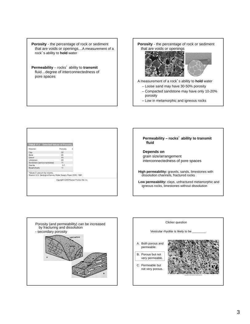
Porosity - the percentage of rock or sediment that are voids or openings…A measurement of a rock’s ability to hold water
Permeability – rocks’ ability to transmitfluid…degree of interconnectedness of pore spaces
Porosity - the percentage of rock or sediment that are voids or openings
A measurement of a rock’s ability to hold water
– Loose sand may have 30-50% porosity
– Compacted sandstone may have only 10-20% porosity
– Low in metamorphic and igneous rocks
Permeability – rocks’ ability to transmit fluid
Depends ongrain size/arrangementinterconnectedness of pore spaces
High permeability: gravels, sands, limestones with dissolution channels, fractured rocks
Low permeability: clays, unfractured metamorphic and igneous rocks, limestones without dissolution
Porosity (and permeability) can be increased by fracturing and dissolution
- secondary porosity Vesicular rhyolite is likely to be ________.
Clicker question
A. Both porous and permeable.
B. Porous but not very permeable.
C. Permeable but not very porous.

4
How fast does groundwater move?Rate controlled by 2 things:1. Driving force “gradient of potential energy” think of the water table’s slope
2. permeability How easily water moves through subsurface
Rates extremely variable
< 1 cm/year to km’s/year
Darcy’s Law Q = discharge (per unit area) (m/day)
K = coefficient of permeability (m/day)
h1 = beginning height (m)
h2 = ending height (m)
L = distance (m)
L
Q = K(h1– h2)
LFlow rate
Groundwater: Outline1. Groundwater intro and activity
2. Water table and groundwater flow
3. Darcy’s Law and the driver for groundwatermovement
4. Groundwater storage: aquifers & aquitards
4. Groundwater problems (e.g., contamination, pumping, etc.)
How does most groundwater exist within the subsurface?
A. As large pools of water within large pockets (caverns) in rocks.
B. Within cavernous regions occupied by rivers of water that flow underground.
C. Within the small open spaces between the grains of rocks and sediments.
D. Both A and BE. None of the above
Aquifer: geologic unit that stores and is capable of transmitting significant water, must be both porous and permeable
Aquitard: low permeability rock formations that retard (or slow down) the flow of water to or from an adjacent aquifer
Unconfined AquiferAt shallow depth
Water table is the top boundary
Recharged by precipitation infiltrating
Confined Aquifer Deeper
Confined on top by a less permeable layer
Recharged slowly

5
An aquifer must be:a. both permeable and porous.b. neither permeable nor porous.c. permeable, but not necessarily porous.d. porous, but not necessarily permeable.
Perched water table Above the main water table
In unsaturated zones
Due to lenses of less permeable rocks (e.g., shales or clays)
Artesian (confined) aquifer: under high pressure
Water in wells rises above the top of the aquifer.
City water systems can be considered artificial artesian systems.
Well #___ is a flowing artesian well and well #___ is a well that must be pumped
from an unconfined aquifer?(Assume that only the very bottom of the well is open)
A) 1, 2 B) 2, 3 C) 3, 4 D) 1, 4 E) 2, 4
SpringLocation where the water table intersects the surface or where groundwater is discharged in general
Marble CanyonGrand Canyon National Park

6
Groundwater: Outline1. Groundwater intro and activity
2. Water table and groundwater flow
3. Darcy’s Law and the driver for groundwatermovement
4. Groundwater storage: aquifers & aquitards
4. Groundwater problems (e.g., contamination, pumping, etc.)
Problems Associatedwith Groundwater
• Overuse• Subsidence• Contamination
- Salt water intrusion- Hard water, pollutants
Drawdown due to Over Pumping Friday’s in-class activity
If pumping > recharge
Subsidence due to groundwater withdrawal in Pahrump Valley, Nevada
If pumping > recharge
Subsidence due to groundwater withdrawal in Pahrump Valley, Nevada

7
If pumping > recharge
Subsidence due to groundwater withdrawal in Pahrump Valley, Nevada
If pumping > recharge
Subsidence due to groundwater withdrawal in Pahrump Valley, Nevada
If pumping > recharge
Subsidence due to groundwater withdrawal in Pahrump Valley, Nevada
If pumping > recharge
Subsidence: when water is removed, sediment compacts, lowering ground surface.
San Joaquin Valley subsidence
DenverBasin
Aquifers
Barkmann, 2004
As of Feb 2001:~34,000water wells were drilled in the Denver Basin
Non-renewable resource
Denver BasinCross Section
West East
Barkmann, 2004

8
Ogallala Aquifer: Largest in the U.S.
First used for irrigation in the late 1800s
1950s: large-scale exploitation
Today: ~170,000 wells used for irrigation
Water table ~200’ lower in some areas!
Setting of the Ogallala Aquifer
Unconfined aquifer; water levels dropping in south; some parts may run dry (graphs below)
17.11.a
Ogallala Water Supplies and Usage
Thickest in northMore rain in east Water table decline greatest in south (Kansas & Texas)
17.11.b-c
Water Quality and Groundwater Movement
Groundwater ContaminationSources:Pesticides/herbicides/fertilizers
Landfill pollutants
Sewage
Acid mine drainage
Radioactive waste
Oil and gasoline
Salt water intrusion
Saltwater Intrusion

9
Question: Why is ground water flow direction changing here?
A) Pumping lowers water table so that it is tilted towards community well
B) Bacteria expand and push water away from septic tank
C) Drought causes water tableto become lower
D) Septic wastes always flowtowards wells open to the air