groundwater availability and conjunctive use assessment in
TRANSCRIPT

Groundwater Availability and Conjunctive Use Assessment in the
Eastern Nile
Groundwater Monitoring Design
October, 2019
Addis Ababa, Ethiopia


Nile Basin Initiative (NBI)
Eastern Nile Subsidiary Action Program (ENSAP)
Eastern Nile Technical Regional Office (ENTRO)
Groundwater Availability and Conjunctive Use Assessment in the
Eastern Nile
Groundwater Monitoring Design
October, 2019Addis Ababa, Ethiopia
ENTRO is an organ established to implement the Eastern Nile Subsidiary Action Program within the framework of Nile Basin Initiative
Egypt Ethiopia South Sudan Sudan

This publication is produced as part of Nile Cooperation for Results project (NCORE) implemented by ENTRO and was made possible with the financial support from Cooperation in International Waters in Africa Program (CIWA) administered by the World Bank.
©2019 Eastern Nile Technical Regional Office
P.O. Box: 27173, 1000 Addis Ababa, Ethiopia
First edition: 2020
DISCLAIMER
The content of this publication do not necessarily reflect the views of the Eastern Nile Technical Regional Office (ENTRO), the World Bank, or Eastern Nile member countries. The findings, interpretations, and conclusions expressed herein are those of the author(s) and do not necessarily reflect the views of ENTRO. ENTRO does not guarantee the accuracy of the data included in this work. The maps in this report are provided for the convenience of the reader. The designations employed and the presentation of the material in these maps do not imply the expression of any opinion whatsoever on the part of ENTRO concerning the legal or constitutional status of any administrative region, state or governorate, territory or sea, or concerning the delimitation of any frontier.
Trademark names and symbols are used in an editorial fashion with no intention of infringement on trademark or copyright laws. The Eastern Nile Technical Regional Office regrets any errors or omissions that may have been unwittingly made in the report.
No part of this publication may be reproduced or distributed, in any form, for sale or other commercial purposes without prior permission from ENTRO. ENTRO would appreciate receiving a copy of any publication that uses this report as a source.

1Groundwater Monitoring Design
Groundwater monitoring design for the Eastern Nile Basin
General
Groundwater throughout the Nile Basin is used for a variety of purposes but its most common use is for drinking water supply for rural and urban communities. Monitoring of groundwater sources is important to assess over-abstraction, which can lead to drawdown of the groundwater table or reduction in surface water sources (reduced river base flow, drying up of springs, and depletion of aquifers). Groundwater quality is also an important consideration and monitoring is necessary to assess the impact of pollution sources (urban, industrial, mining, agricultural, etc.) for groundwater uses.
Groundwater monitoring of both levels and quality will depend on where the resource is currently being abstracted or where potential exists to develop its use for various purposes. A typical groundwater monitoring program will involve monthly analysis of both level and quality at key locations. The common practice is that; groundwater monitoring should have certain predefined objectives.
The general objective of the monitoring program is to supply data for characterization of the regional groundwater systems, identification of trends in time and prediction of the regional impacts.
The design of a cost effective and purposeful monitoring network largely depends on the stages of groundwater (aquifer) assessment and development, the importance of the aquifer, the threats on the aquifers, as well as the natural resilience and fragility of the aquifers. Figure 1 shows some general recommendation as to what type of monitoring is required depending on the degree of groundwater development. Design of groundwater monitoring network also depends on financial and institutional capacity to sustainably run monitoring network.
Figure 1. Purpose of monitoring systems depending on the degree of use of the aquifers and the threat levels on the
aquifers, taken from GWMATE technical report

2 Groundwater Availability and Conjunctive Use Assessment in the Eastern Nile
In situation whereby financial resources a major constraint, groundwater observation or sampling will usually be done at any suitable observation point available. In a later stage of groundwater development, a reference monitoring network may be further upgraded to a “primary network”, which is a dedicated tool for overall observation of regional groundwater bodies. At that stage the groundwater potential becomes sufficiently well-known and when the economic returns of monitoring become more obvious, more investments are justified to increase the level of detail.
In order to propose an optimal monitoring design for the Eastern Nile, a preliminary assessment of key indicators of monitoring needs has been conducted. The monitoring need depends on the current use of the aquifers, the threats felt to the aquifers, the strategic importance of the aquifers for drinking water and irrigation water uses, and the planned groundwater resources development.
Indicators of monitoring needs in the Eastern Nile Sub-Basins
The stages of groundwater development, the threats on the aquifers as well as the importance of the aquifers for an imminent use are extremely variable in the Eastern Nile Region. Some aquifers are extensively developed and threatened (e. g. the Nile Delta and the Nile Valley aquifer in Egypt), other aquifers are under incipient stage of use (e.g., the volcanic aquifers in the highland Ethiopia). Some aquifers have enormous importance for socio economic development potential or facing pollution threats. There is large geographic difference between where renewable groundwater exists and where large aquifer storage exists. Aquifers in the headwater sub-regions contain large renewable groundwater resources while in the arid downstream sub-regions, despite the high groundwater storage, renewable groundwater resources are meager.
The total renewable groundwater resources are small, in the order of 40-Billion m3/yr, of which 75 % of the renewable groundwater occurs in Ethiopia. However, groundwater storage is substantially high (>250,000 Billion Cubic Meter), of which much is contained downstream. Groundwater abstraction is estimated at nearly 12 billion m3, most of which is taking place from the non-renewable sources or from aquifer connected to surface waters. In the latter case, basically, it is the supplemental irrigation water which is being abstracted. Most of these abstractions (>10 Billion m3/yr) is happening for irrigation water use in Egypt and Sudan. This means the there is an urgent need for initiating groundwater monitoring in the Eastern Nile Region.
The proposed groundwater monitoring design shall depend also on the current institutional capacity and the current monitoring practices in each of the Eastern Nile countries. Currently Egypt have the most advanced groundwater monitoring network while in the other three countries - Ethiopia, Sudan and South Sudan, effective groundwater water monitoring systems is at its infancy or nonexistent. The current monitoring practices in each of the Eastern Nile countries is given below.

3Groundwater Monitoring Design
Current groundwater monitoring practice in Eastern Nile Basin
Egypt:
Overview of responsible ministries
X The Ministry of Water Resources and Irrigation (MWRI) is responsible for the management of water resources in Egypt.
X The lead institution responsible for the collection of surface water level and discharge within the Nile Basin is the Nile Water Sector at the MWRI.
X Groundwater monitoring is under the Groundwater Research Institute at the National Water Research Center of the MWRI.
X Water quality monitoring is performed by the National Water Research Center (NWRC) for surface water and groundwater, the Egyptian Environmental Affairs Agency (EEAA) at the Ministry of Environment for the protection of the Nile River from industrial pollution and for the protection of the coastal waters and the marine environment, and the Ministry of Health for the safety of drinking water and water quality.
X The Nile Water Sector is in charge of collection of rainfall and evaporation data within the Nile Basin. The Egyptian Meteorological Authority (EMA) collects meteorological data nationwide. The Ministry of Agriculture and the agricultural research stations collect agro-climate data.
Groundwater monitoring
X Groundwater is monitored once a year in 223 wells across Egypt, with focus on salinity in the Delta area and pollution of the groundwater system within the Nile Basin in Egypt.
Ethiopia:
Overview of responsible ministries
X The Hydrology and Water Quality Directorate under the Ministry of Water, Irrigation and Energy is the directorate responsible for surface water, groundwater, and water quality monitoring and data processing. Additional activities include flood forecasting and early warning systems, reservoir monitoring and management, and workshop and laboratory activities. Under the Hydrology and Water Quality Directorate nine regional hydrology offices exist. River basin authorities responsible to the ministry have been established, and are beginning to undertake hydrological monitoring operations within their areas.
X The National Meteorology Agency (NMA) is the agency responsible for precipitation and meteorological monitoring within Ethiopia. There are a total of 11 NMA Branch Offices located throughout the country.
Groundwater monitoring
X Groundwater monitoring is fairly recent with abstractions being measured at few stations around major towns. Due to only recent developments in groundwater monitoring, no relationship between aquifer responses to abstraction or recharge have been defined.
4 Groundwater Availability and Conjunctive Use Assessment in the Eastern Nile
X Groundwater data are stored in databases labeled as Ethiopian National Groundwater Information System “ENGIS”
X ENGIS contains data entry of around 40,000 water schemes. The data entries contain information on water scheme location, type, use, yield, attributes, well logs, etc. Because of lack of information system, the database is not accessible for public use.
South Sudan:
Overview of responsible ministries/institutions
X The responsible government agency for both surface water and groundwater monitoring in the Republic of South Sudan (RSS) currently is the Directorate of Hydrology and Surveys (DHS) under the Ministry of Water Resources and Irrigation (MWRI). South Sudan is run on the basis of a decentralised system of government; and the sub-national departments liaise with MWRI-RSS on water resources management.
X The South Sudan Meteorological Department (SSMD) under the department of South Sudan Civil Aviation Authority is responsible for meteorological monitoring. This institution resides within the Ministry of Transport.
Groundwater
X Generally, the water resources monitoring system in South Sudan has suffered great deterioration and under established in the past due to many factors.
X At present, there is no groundwater centralised monitoring system where real time measurements are regularly taken such as water level fluctuation in observation wells, groundwater abstraction and water quality measurements. However, at projects level, a few groundwater monitoring wells are being established.
X UNICEF had developed during Operation Lifeline Sudan (OLS), drinking water points database and handed it over to MWRI-GoSS after the Comprehensive Peace Agreement (CPA); and continued supporting its establishment and development as a full fledge information management system. MWRI-RSS, together with UNICEF and through Multi-Donor Trust Fund (MDTF) furthered the efforts to an extent of uploading the RSS Water Information Management System (WIMS) online, which can be accessed through the WPDx website.
X The database contains basic well data such as borehole coordinates, drilling depth, dates, static and dynamic water levels, well yield, pump type, and pump setting depth and water suitability. However, it is noted that several fields and entries are incomplete. Very important information, such as well lithology, water quality parameters and pumping test data is not included in the database. As such currently groundwater development and information are scattered among many governmental authorities and implementing partners (NGO’s, UNICEF, etc.).
5Groundwater Monitoring Design
Sudan:
Overview of responsible ministries
X The Sudan Ministry of Water Resources and Electricity (MWRE), is responsible for water resources and electricity management.
X The lead institution responsible for the collection of rivers water level and discharge within the Nile Basin is the Nile Water Directorate at the MWRE, while the surface water level and discharges for wadis are monitored by the General Directorate of Groundwater and Wadis at the MWRE.
X The lead institution responsible for the surface water quality monitoring is General Directorate of Groundwater and Wadis of the MWRE. Other supporting institutions that monitor water quality include the Ministry of Health, States drinking water corporations, the Ministry of Agriculture and Irrigation, and UNICEF.
X The General Directorate of Groundwater and Wadis at the MWRE, is the lead institution in the monitoring of groundwater level and groundwater quality.
X The Hydraulic Research Center of the MWRE at Wed Medani is the lead institution in sediment monitoring.
X The Sudan Meteorological Authority (SMA), is the lead institution responsible for providing meteorological, agro-climate, and rainfall data. The MWRE and Ministry of Agriculture and Irrigation are two other support institutions in the collection of rainfall and climate data.
Groundwater
X There was an active groundwater level and water quality monitoring network in the 50’s. The program has been idle during the past few years due to limited financial resources. Monitoring is only carried sporadically by water supply offices, groundwater investigation projects, and NGOs such as UNICEF
General requirement in groundwater monitoring
Groundwater is an extensive, concealed and inaccessible resource and (in contrast to surface water) changes in quantity and quality are often very slow processes occurring below large land areas. These changes cannot be determined by simple one-off snapshot surveys alone, and require more elaborate monitoring networks and data interpretation. The primary goal of aquifer management is to control the impacts of groundwater abstraction and contaminant loads, and monitoring aquifer response and quality trends provide key inputs for this goal.
The evaluation of groundwater issues and the implementation of management solutions require hydrogeological data that are in part ‘baseline’ and in part ‘time-variant’ in character—the collection of the ‘time-variant component’ is what is usually considered ‘groundwater monitoring’. Groundwater monitoring thus comprises the collection, analysis and storage of a range of data on a regular basis according to specific circumstances and objectives. The type and volume of data required will vary considerably with the management issue being addressed, but is also inevitably dependent upon available financial resources.

6 Groundwater Availability and Conjunctive Use Assessment in the Eastern Nile
Abstraction Wells. When water wells are drilled, they provide one-off unique in-situ data on the groundwater resource and its variation with depth—and data acquired during drilling (borehole logging) and initial test pumping form key baseline reference information on groundwater quantity and quality, in addition to their value for the determination of abstraction well potential. However, data collected from water wells once operational are normally more difficult to interpret, because groundwater levels are affected by the drawdown-recovery cycle and pumped-sample quality reflects the variable mixing of groundwater from a wide range of aquifer depths and residence times.
Observation Wells. These are dedicated monitoring stations, sited and designed to detect potential changes in groundwater flow and quality—design parameters include selection of depth for the intake screen, frequency of measurement (if not continuous) and selection of quality parameters. To overcome the widespread presence of depth variation in hydraulic head and/or groundwater quality, nested piezometers or well clusters can be used. Piezometer nests are more cost effective than observation well clusters, but should only be used if proper sealing can be achieved to prevent vertical flow between their screens.
General consideration in monitoring design [GWMATE1 guideline]
Groundwater level measurements (in observation, unused and abstraction wells) can be made manually or automatically. Manual water-level recorders give a visual or audio signal when their probe is immersed in water. Automatic recorders are small probes (divers) installed in observation or abstraction wells, which store water-level and temperature data at pre-set intervals, and can be downloaded to a data-logger during inspection visits or telemetrically transmitted enabling remote monitoring.
Groundwater monitoring networks must be designed by specialists on the basis of management requirements, but financial constraints are often a problem and require choices to be made. The inclusion of production and disused wells will help increase the number of monitoring points. But it may also be important to identify the presence of areas with marked vertical variation in groundwater head, which tend to occur below groundwater recharge or discharge areas and in layered systems.
Operation of a monitoring network requires manpower and logistical resources, together with clear procedures to assure the continuous generation of reliable data. Lack of these resources is often a constraint in maintaining the necessary level of data collection and quality control. Delegation of monitoring responsibility to the local level with self-monitoring by water users will help to overcome this problem.
Groundwater data storage, evaluation and retrieval are essential components of effective monitoring. The flow of data from the field stations to central storage facility (database) should be assured, and qualified personnel be available to review data collected. Groundwater level changes observed through monitoring may have widely differing causes and should be carefully evaluated to determine the correct management action required.
1 GWMATE GW•MATE is a core group of experienced specialists in the multidisciplinary and multifaceted subject of groundwater management and formerly working for the World Bank.

7Groundwater Monitoring Design
Monitoring requirements and monitoring design for the Eastern Nile basin aquifers
In order to propose the most cost-effective monitoring design proposal an assessment of the stages of groundwater development in each aquifer of the Eastern Nile sub-basins has been conducted. The assessment includes determining the degree of use of the aquifers, the importance of the aquifers, the level of threat on the aquifers, the degree of pollution and contamination observed, and the national plans to exploit this aquifer for productive and consumptive uses. Accordingly, some aquifers have been proposed for primary monitoring design, others for secondary monitoring design and the most threatened aquifers for tertiary level monitoring design (see figure 1 for the definition of the monitoring levels). In order to be more practical and cost effective within each monitoring category, priority aquifers have been identified. The priority has been selected based on the aquifer potential of the individual aquifers. The categorization of the monitoring design required and the prioritization of the aquifers for the specified type of monitoring have been validated by government representatives during the process of this project. Table 2a, b and c show the categorization of the aquifers for the specified monitoring design type while the colors within each category shows the priority within that category, red meaning the highest priority and blue means the lowest priority. It should be noted that all the aquifers in Egypt are proposed for secondary or tertiary level monitoring, reflecting the degree of use and threats on all the major aquifers in Egypt.
For the high priority categories of the aquifers proposed for primary monitoring the proposed monitoring design is the installation of one water level measuring device per 10,000 km2 and an annual water quality test on the proposed monitoring boreholes. For the low priority categories one monitoring device per 50,000 km2 may be sufficient.
Aquifers proposed for Primary Monitoring
Ethiopia Basement aquifer High-grade basement rocks of western Ethiopia (Abay sub basin) and associated regolithLow grade fractured aquifers of northern Ethiopia (Tekeze sub basin)
Mesozoic Multilayered sedimentary rocks including Adigrat sand stone
Adigrat sandstone
Carbonate rocks and marls and shales
Cenozoic volcanic cover Lower basalt unit
Upper basalt unit
Shield volcanics
Quaternary basalts
Loose alluvio-lacustrine sediments
Lake Tana Basin
Alwero Sandstone and associated sediments
Dabus alluvial and marshes

8 Groundwater Availability and Conjunctive Use Assessment in the Eastern Nile
Sudan Basement
Nubian Sandstone
Volcanics
Umm Ruwaba Umm Ruwaba and Gezira formations
Gezira formation
Loose quaternary sediments Superficial Alluvial aeolian sediments
South Sudan
Basement Complex (BC)
Metamorphic gneisses, occasionally covered with lateritic soil, commonly referred to as ironstone, occupying about 42% of the surface area of South Sudan.Schists metasediments, associated with gold, occupying only (3%)
Metamorphosed Igneous
Nubian Sandstone
Sandstone, with low percentage of clay and iron oxide concretions Mudstone, occurring in variety of colours, with iron ore as cement
Volcanic and Intrusive Rocks
Weathered basalts
Undifferentiated lavas
Um Ruwaba formation
Fluviatile
Lacustrine
Loose quaternary sediments
Superficial alluvial deposits (mainly clays in the plains)
Alluvium or Alluvial deposits (Valley Fills and Riverbank terraces), which are fine grained soils along the rivers, streams or Khors; gravelly soils on highlands; and sandy soils on riverbeds
Laterite and lateritic soils, which form dissected sheets
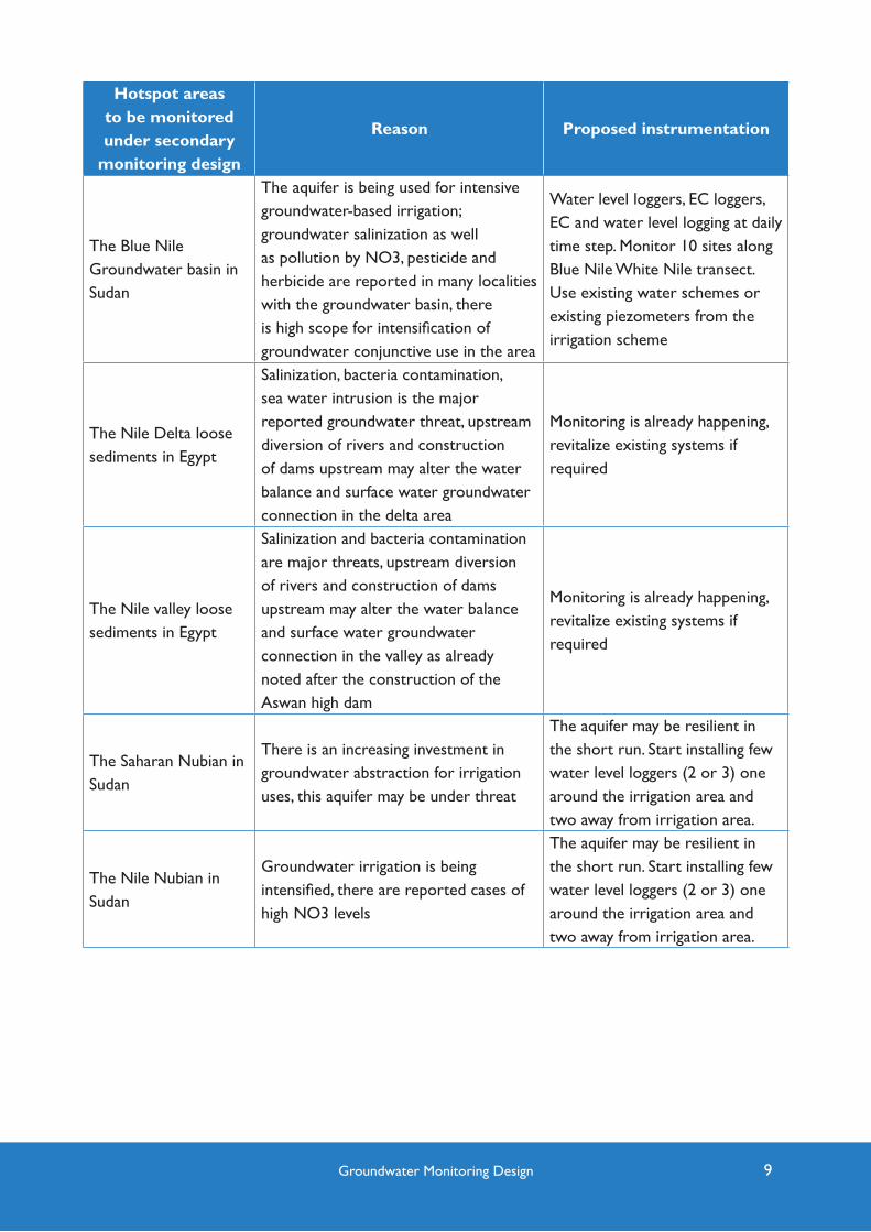
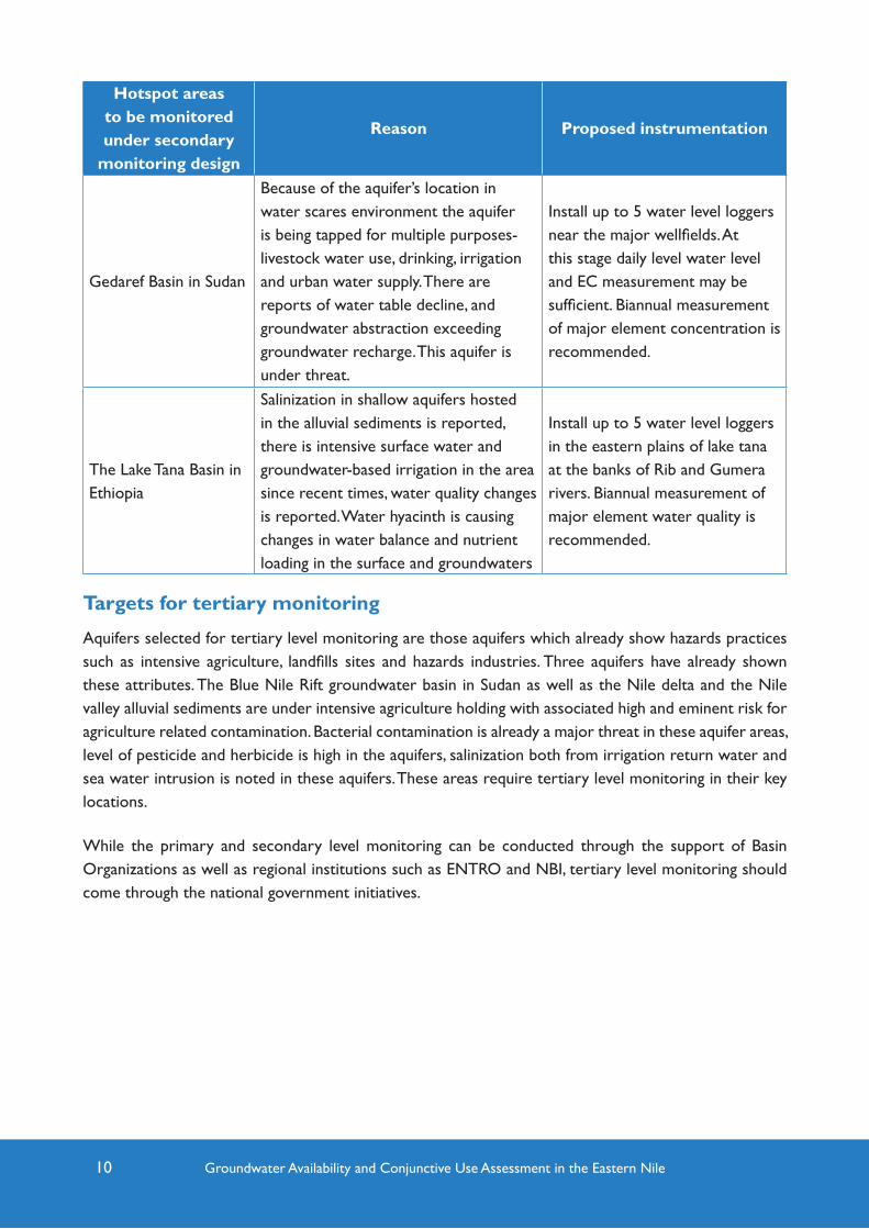
Targets for secondary monitoring
These aquifers were selected for secondary level monitoring for the protection against potential impacts. These aquifers are currently under intensive use, water level decline, salinization, and reported pollution of the groundwaters sources. Or these aquifers are of strategic nature, in that major groundwater abstraction is happening, several well fields tap into these aquifers serving public water supply sources, and some major urban areas tap water from these aquifers.
9Groundwater Monitoring Design
Hotspot areas to be monitored under secondary
monitoring design
Reason Proposed instrumentation
The Blue Nile Groundwater basin in Sudan
The aquifer is being used for intensive groundwater-based irrigation; groundwater salinization as well as pollution by NO3, pesticide and herbicide are reported in many localities with the groundwater basin, there is high scope for intensification of groundwater conjunctive use in the area
Water level loggers, EC loggers, EC and water level logging at daily time step. Monitor 10 sites along Blue Nile White Nile transect. Use existing water schemes or existing piezometers from the irrigation scheme
The Nile Delta loose sediments in Egypt
Salinization, bacteria contamination, sea water intrusion is the major reported groundwater threat, upstream diversion of rivers and construction of dams upstream may alter the water balance and surface water groundwater connection in the delta area
Monitoring is already happening, revitalize existing systems if required
The Nile valley loose sediments in Egypt
Salinization and bacteria contamination are major threats, upstream diversion of rivers and construction of dams upstream may alter the water balance and surface water groundwater connection in the valley as already noted after the construction of the Aswan high dam
Monitoring is already happening, revitalize existing systems if required
The Saharan Nubian in Sudan
There is an increasing investment in groundwater abstraction for irrigation uses, this aquifer may be under threat
The aquifer may be resilient in the short run. Start installing few water level loggers (2 or 3) one around the irrigation area and two away from irrigation area.
The Nile Nubian in Sudan
Groundwater irrigation is being intensified, there are reported cases of high NO3 levels
The aquifer may be resilient in the short run. Start installing few water level loggers (2 or 3) one around the irrigation area and two away from irrigation area.
10 Groundwater Availability and Conjunctive Use Assessment in the Eastern Nile
Hotspot areas to be monitored under secondary
monitoring design
Reason Proposed instrumentation
Gedaref Basin in Sudan
Because of the aquifer’s location in water scares environment the aquifer is being tapped for multiple purposes- livestock water use, drinking, irrigation and urban water supply. There are reports of water table decline, and groundwater abstraction exceeding groundwater recharge. This aquifer is under threat.
Install up to 5 water level loggers near the major wellfields. At this stage daily level water level and EC measurement may be sufficient. Biannual measurement of major element concentration is recommended.
The Lake Tana Basin in Ethiopia
Salinization in shallow aquifers hosted in the alluvial sediments is reported, there is intensive surface water and groundwater-based irrigation in the area since recent times, water quality changes is reported. Water hyacinth is causing changes in water balance and nutrient loading in the surface and groundwaters
Install up to 5 water level loggers in the eastern plains of lake tana at the banks of Rib and Gumera rivers. Biannual measurement of major element water quality is recommended.
Targets for tertiary monitoring
Aquifers selected for tertiary level monitoring are those aquifers which already show hazards practices such as intensive agriculture, landfills sites and hazards industries. Three aquifers have already shown these attributes. The Blue Nile Rift groundwater basin in Sudan as well as the Nile delta and the Nile valley alluvial sediments are under intensive agriculture holding with associated high and eminent risk for agriculture related contamination. Bacterial contamination is already a major threat in these aquifer areas, level of pesticide and herbicide is high in the aquifers, salinization both from irrigation return water and sea water intrusion is noted in these aquifers. These areas require tertiary level monitoring in their key locations.
While the primary and secondary level monitoring can be conducted through the support of Basin Organizations as well as regional institutions such as ENTRO and NBI, tertiary level monitoring should come through the national government initiatives.

11Groundwater Monitoring Design
Water quality hotspot areas to be monitored for
water qualityReason Proposed design
Blue Nile groundwater basin
X Salinization
X Pesticide pollution
X Herbicide pollution
X Nitrate pollution
Installation of water level and EC loggers at appropriate locations to be selected by the National Governments.
Periodic (monthly) measurement of water quality parameters including: bacteria, nitrogen, pesticides, herbicides, heavy metals, may be required. The detailed parameters need to be selected by the National governments.
Nile Delta
X Sea water intrusion
X Pesticide pollution
X Bacterial contamination
X Nitrate pollution
X Salinization
Nile Valley
X Pesticide pollution
X Bacterial contamination
X Nitrate pollution
X Salinization
Instrumentation requirement for groundwater monitoring
Pressure transducers are required for automatic water level measurement. Some transducers are fitted with TDS/EC and temperature logging capabilities. Using a pressure sensor to measure level is premised on water having a uniform weight at a given depth. In other words, a column of water of a specific height will always exert the same amount of pressure on a transducer. This pressure reading is then converted to water level in a borehole. To convert the pressure reading into water levels the air pressure at the specific location needs to be corrected for. This can be done through measurement of air pressure using the specifically design pressure transducers. A number of brands and designs are available in the market.
A contact gauge will be required for the manual measurement of depth to water, temperature, and conductivity in groundwater. The contact gauge will consist of measured tape with a probe placed on a drum held by a stable frame, which is easy to carry. Once the probe touches the water surface a signal is produced and the distance to water can be read. The contact gauge is suitable for depths of 15 to 100 m. The contact gauge can be equipped with a conductivity sensor and display to show values of temperature, conductivity and TDS (Total Dissolved Solids).
A bailer will be required to collect a groundwater sample for laboratory analysis. The bailer is to be a long-life reusable bailer constructed of virgin high-density white PVC or Teflon for environmental sampling and bailing applications. The bailer must be 50mm in diameter and 1000m in length with recess

12 Groundwater Availability and Conjunctive Use Assessment in the Eastern Nile
check. The bailer must be designed to have a trouble-free rigid tethering attachment and to have accurate pouring capability. Each bailer is to be provided with a roll (at least 150m) of 18 Nylon braid bailer cord.
Station Type Data Parameters Method Frequency
Groundwater Level Pressure transducerAs specified above depending on the proposed monitoring level
Quality Field Kit – On site Time of Visit depending on the proposed monitoring level
Samples - Laboratory Time of visit depending on the proposed monitoring level
Some examples of pressure transducers
A number of brands and designs for water level monitoring devices are available in the market and in practice. The choice of the brand should be the matter of procurement procedure within the institution responsible for the monitoring programs. The table below shows list and attributes of some brands available in the market.
Brand Name
Short descriptionDetailed specification of the
monitoring deviceIn-Situ
In-Situ Inc. designs, manufactures, and rents water quantity and quality instrumentation for groundwater, surface water, and coastal waters. In site has emote data transfer mechanism through mobile phones or internet networks
https://in-situ.com/products/water-level-monitoring/rugged-troll-200/
On SETOnset’s HOBO MX2001 is water level data logger designed for wireless setup and download from mobile devices via Bluetooth Low Energy (BLE) technology. The logger provides wireless access to high-accuracy water level and temperature measurements right from a mobile phone or tablet.
https://www.inmtn.com/docs/Onset/Onset-HOBO-MX2001-Water-Level-Logger-IEI.pdf
SolinistSolinst has various design of water level and conductivity logging devices. The design has both field based data collection and downloading mechanism and telemetry based data transfer methodologies
https : / /www.so l inst .com/products/data logger s -and- te lemetr y /3001-levelogger-ser ies/ltc-levelogger/?sc_cid=Bing-NA-EST-3001-LTCEdge-textad&msclkid=ba6201d761cf16743db05c58fb85fab7

13Groundwater Monitoring Design
Cost implication of groundwater monitoring
Given the scope of the current work, detailed cost breakdown for initiating a full-fledged groundwater monitoring program as specified in the current work is not feasible. Cost associated with groundwater monitoring include a) costs to be incurred by the institutions running the monitoring (e.g staff cost, data management cost, etc), b) cost for transport to install monitoring devices and collect data and c) cost for procurement of the monitoring devices. The following table shows cost breakdown required to procure sufficient number of monitoring devices for the proposed primary and secondary level monitoring practices.
Aquifer NameProposed level of monitoring
Number of water level monitoring
device
Parameters to be
monitored
Cost estimate
USD
Upper Basalt Aquifer, Ethiopia Primary 5 Water level 2500
Shield Volcanic aquifer Ethiopia Primary 2 Water level 1000
Quaternary basalt aquifer, Ethiopia Primary 2 Water level 1000
Lake Tana Alluvial Sediments, Ethiopia
Primary/secondary 5Water level
and EC5000
Alwaro Sandstone Aquifer, Gambella
Primary 2 Water level 1000
Nubian Sandstone Aquifer, SudanPrimary and secondary
6Water level
and EC6000
Umm Ruwaba aquifer, Sudan Primary 3 Water level 1500
Loose Quaternary sediments, Sudan
Primary 2 Water level 1000
Umm Ruwaba aquifer, South Sudan Primary 2 Water level 1000
Loose Quaternary aquifer, South Sudan
Primary 2 Water level 1000
The Blue Nile Groundwater Basin, Sudan
Secondary 10Water level
and EC10000
Gedaref aquifer system, Sudan Secondary 5Water level
and EC5000
Barometric logging of all aquifers
12 Barometric 6000
Total 58 42,000
The cost provided in the table above is meant to cover only the monitoring equipment cost. The equipment cost does not take into account the cost associated with data downloading or data transfer.

14 Groundwater Availability and Conjunctive Use Assessment in the Eastern Nile
References
IGRAC, 2008. Guideline on: Groundwater monitoring for general reference purposes. Utrecht.
Albert Tuinhof, Stephen Foster, Karin Kemper, Héctor Garduño, Marcella Nanni (GWMATE WorldBank, 2006). Groundwater Monitoring Requirements for managing aquifer response and quality threats, briefing note number 9.

P.O. Box 27173/1000
Addis Ababa, Ethiopia
Telephone: +251 (11) 646 1130/646 1132
Fax: +251 (11) 645 9407
Email: [email protected]
Web site: entro.nilebasin.org
ENTRO is an organ established to implement the Eastern Nile Subsidiary Action Program within the framework of Nile Basin Initiative