ground-water management solutions for industries-2008
TRANSCRIPT

8/8/2019 Ground-water Management Solutions for Industries-2008
http://slidepdf.com/reader/full/ground-water-management-solutions-for-industries-2008 1/65
GROUND WATER
MANAGEMENT SOLUTIONS FOR INDUSTRIES
By
Dr. S. K. JainChairman ,GWMICC (P) LTD, Jaipur.
E mail: [email protected]
Mob. ± 09829067474, 09414070292
Ph: 0141-2650724, 2650548

8/8/2019 Ground-water Management Solutions for Industries-2008
http://slidepdf.com/reader/full/ground-water-management-solutions-for-industries-2008 2/65
Overall Water ScenarioOverall Water Scenario1. 97.2% of total water resources is saline, mainly in ocean
etc.2. Only 2.8% is available as fresh water on planet earth.
3. Out of 2.8% of fresh water, 2.2% is surface water in theform of rivers, lakes, ponds etc.
4. Therefore, only 0.6% of the total available water on earthexists in the form of groundwater.
5. Areas like Rajasthan state does not have much of surfacewater and we mainly depend on groundwater.InRajasthan, total available ground water is around 12000
million cubic meters per annum, where as, presentrequirement is over 15 thousand million cubic meters andthe same would go up to the level of 25 thousand millioncubic meters in the year 2025.
6. Hence, groundwater becomes very much precious
resource for us. There is an urgent need of water conservation and management.

8/8/2019 Ground-water Management Solutions for Industries-2008
http://slidepdf.com/reader/full/ground-water-management-solutions-for-industries-2008 3/65
Total water resources both for
Drinking and irrigational needs
Economic & social objectives
Constraints ± Existing Irrigation
And hydropower works/
groundwater quality & quantity
Broad principles of Resource allocation
Cropping pattern- Agro climate
Zones/ water requirements
Engineering and economic studies
Alternative proposals
and policies
System
Models
Evaluation
Final Projects

8/8/2019 Ground-water Management Solutions for Industries-2008
http://slidepdf.com/reader/full/ground-water-management-solutions-for-industries-2008 4/65
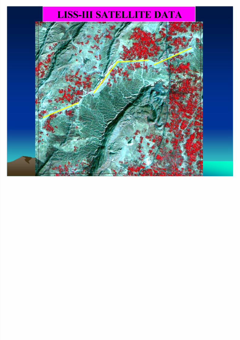
Remote sensing studiesRemote sensing studies
Satellite based data provide quick and useful baseline information on the
factors controlling the occurrence and movement of groundwater. A
systematic study and interpretationinterpretation of of satellitesatellite imageriesimageries lead to better
delineation of perspectiveperspective groundground water water zoneszones in a region. Such
perspective zones identified from the satellite imageries are followed upon the ground through detaileddetailed hydrogeologicalhydrogeological andand geophysicalgeophysical
investigationsinvestigations before actual drilling is carried out for exact assessment
about potential site .
The usefulness of satellites data in identifyingidentifying linear linear featuresfeatures such as
lineaments representing fractures, faults, shear zones, which are usuallythe zoneszones of of localizationlocalization oaf oaf groundwater groundwater & certain geomorphic features
such as alluvial fans, valley fills, palaeopalaeo--channelschannels etc. often form good
aquifers as well establishes perspective groundwater zones in a region
8/8/2019 Ground-water Management Solutions for Industries-2008
http://slidepdf.com/reader/full/ground-water-management-solutions-for-industries-2008 5/65
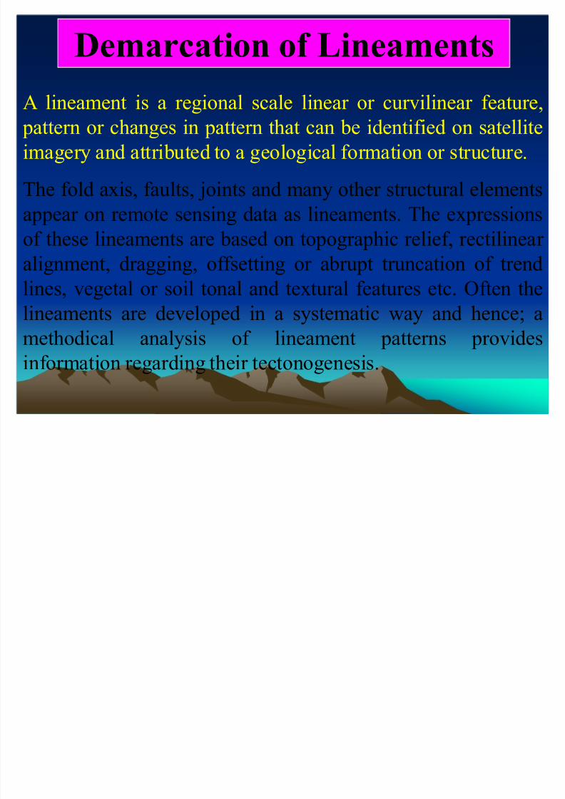
Demarcation of Lineaments
A lineament is a regional scale linear or curvilinear feature, pattern or changes in pattern that can be identified on satellite
imagery and attributed to a geological formation or structure.
The fold axis, faults, joints and many other structural elementsappear on remote sensing data as lineaments. The expressions
of these lineaments are based on topographic relief, rectilinear
alignment, dragging, offsetting or abrupt truncation of trend
lines, vegetal or soil tonal and textural features etc. Often thelineaments are developed in a systematic way and hence; a
methodical analysis of lineament patterns provides
information regarding their tectonogenesis.
8/8/2019 Ground-water Management Solutions for Industries-2008
http://slidepdf.com/reader/full/ground-water-management-solutions-for-industries-2008 6/65
LISS-III SATELLITE DATA

8/8/2019 Ground-water Management Solutions for Industries-2008
http://slidepdf.com/reader/full/ground-water-management-solutions-for-industries-2008 7/65
DETECTION OF UNDERGROUND DETECTION OF UNDERGROUND
WATERWATER
An An adequateadequate supplysupply of of water water isis oneone of of thethe prepre--requisitesrequisites for for developmentdevelopment andand industrialindustrial
growthgrowth.. Groundwater constitutes significant part of of active fresh water resourcesresources of of thethe
worldworld andand isis obviouslyobviously dependable source for for industries particularlyparticularly in areas where
surface water is not available.. However,However, itit isis becomingbecoming moremore andand moremore difficultdifficult toto locatelocate
groundwater groundwater inin thethe presentpresent circumstancescircumstances whenwhen groundwater groundwater isis beingbeing usedused
increasinglyincreasingly withwith moremore advancementadvancement inin humanhuman racerace andand industrialindustrial growthgrowth.. ConventionalConventionalmethodsmethods of of makingmaking hydrogeologicalhydrogeological inventoryinventory of of thethe areaarea areare notnot enoughenough toto preciselyprecisely
exploreexplore deeper deeper zoneszones of of groundwater groundwater availabilityavailability.. Accordingly, Accordingly, thethe techniquetechnique whichwhich willwill
eliminateeliminate toto aa greatgreat extentextent thethe sinkingsinking of of unproductiveunproductive wellswells isis of of greatgreat valuevalue andand thethe
answer answer toto thisthis waswas givengiven byby GeophysicistsGeophysicists inin thethe beginningbeginning of of thethe centurycentury inin thethe formform of of
Geoelectric method of groundwater exploration.. TheThe methodmethod hashas since,since, undergoneundergone
tremendoustremendous improvementimprovement bothboth inin instrumentationinstrumentation andand interpretationinterpretation processprocess abroadabroad asaswellwell asas inin IndiaIndia.. InIn GeoelectricGeoelectric surveying,surveying, electricalelectrical currentscurrents areare injectedinjected intointo thethe groundground
andand subsurfacesubsurface resistivelyresistively variationvariation causedcaused byby geological/geological/ hydrogeologicalhydrogeological conditionsconditions
areare recordedrecorded.. TheseThese variations are the results of subsurface current flow pattern.. TheThe
data,data, thus,thus, gatheredgathered areare interpretedinterpreted toto revealreveal subsurface anomalies usingusing latestlatest
developeddeveloped software¶ssoftware¶s.. For For inin depthdepth analysis,analysis, timetime testedtested interpretationinterpretation techniquestechniques of of
GeoelectricGeoelectric surveysurvey revealsreveals..

8/8/2019 Ground-water Management Solutions for Industries-2008
http://slidepdf.com/reader/full/ground-water-management-solutions-for-industries-2008 8/65
AQUAMETER-A Geophysical
Instrument (Resistivity Meter)

8/8/2019 Ground-water Management Solutions for Industries-2008
http://slidepdf.com/reader/full/ground-water-management-solutions-for-industries-2008 9/65
Water Level Indicator

8/8/2019 Ground-water Management Solutions for Industries-2008
http://slidepdf.com/reader/full/ground-water-management-solutions-for-industries-2008 10/65
INVESTIGATION PLAN
Selection of Feasible sites for construction of suitable groundwater
structures:
In this type of investigation, given area is subjected to following studies :
(a) Hydrogeological Studies
(b) Geoelectric Survey at selected or given spots
Above studies give idea about present availability of water at particular locations & recommendations are made for construction of waterwells/
tubewells with expected yield and quality on the day/period of
investigation.
The method does not indicate about future availability of water and itsutilization in long term but helps in reducing the chances of unsuccessful
tubewells.

8/8/2019 Ground-water Management Solutions for Industries-2008
http://slidepdf.com/reader/full/ground-water-management-solutions-for-industries-2008 11/65

8/8/2019 Ground-water Management Solutions for Industries-2008
http://slidepdf.com/reader/full/ground-water-management-solutions-for-industries-2008 12/65
0 500 1500 2500 4000 5000M
SUT ¡
P¡
D¡
¢
M£
ELI
2045'
VE£ ¢
VAL
¤
UJARAT
JUNAGAD¥
GAND¥
INAGAR
AHMED ABAD
HARAN AS A
KADVAR
70¦ 0'
VAD§
DRA
VAWADI
P ASNAWAD A
M§
RAS A
THARELI
MEGHPUR
INDROY
T O V E R A V A L
T O V E R A VA L
BAD ALPARA
SON ARIYA
BIJ
AJOTHA
N AVDRA
S AVNIISHVARIYA
GORAKHM ADHI
SUND ARPARA
BOL AS A
UMBRI
NAKHAD A
KUKRAS
LAKHAPARA
BOS AN
̈
HAGI A
NAVAGAM AMRAPUR
SARA
VIROD AR
AN ANDPARA
TOBRA
BARUL A
C O A S T A L H I G H W A Y N
©
1 3 2 K V T R A N S M I S S I O N L I N E
P AN AD AR
MULDWARKA
M AT AN A
KANJOT AR
SINGS AR
DHAMLEJ
THORDI
BAREVL A
KAD AS AL A
KHERA
GOHILNIKHANRAKHEJ
BARD A
PEDHAW AD A
KADAVAS AN
MORDI A
GACL
NAVAGAM
D AMLI
7045'
PIP ALI
DUD AN A
DEVLI
R A I L W A Y L
I N E
KADODARA
RON AJ
DEVAL APUR
FACHARIYA
GOVIND APUR
SINDHAJ
BHUWAVAD A
WAD AL A
66 K V TR ANS MISSION LINE
PIKHOR
PRANSLI
PIP ALWA
ALIDRA
PRANCHI
GHANTIYA
VASAWAD
TIMBDI
KHAMBHA
MAHOBATPARA
RANGPUR
BHUVATIMBI AN AND APUR
GANGETHA
RAIDI
SEM ALIYAJ AM ALPUR
ARNEJ
P AWTI
GIRDEOLI
KANT AL A
S ANDHANIDHAR
10Km
OFC[
OFC[
OFC[
Fig.:-8, Map depicting Quantity variation in Ground water and Yield Zones in Buffer Zone of
Lodhva mining lease area.
P AD ARUKA
OFC[
8/8/2019 Ground-water Management Solutions for Industries-2008
http://slidepdf.com/reader/full/ground-water-management-solutions-for-industries-2008 13/65
LODHVA
VILL AGE

8/8/2019 Ground-water Management Solutions for Industries-2008
http://slidepdf.com/reader/full/ground-water-management-solutions-for-industries-2008 14/65
0 500 1500 2500 4000 5000M
SUTRAP AD A
AMRELI
2045'
VERAVAL
GUJARAT
JUN AGADH
GANDHIN AGAR
AHMED ABAD
HARAN AS A
KADVAR
7030'
VADODRA
VAWADI
P ASNAWAD A
MORAS A
THARELI
P AD ARUKA
MEGHPUR
INDROY
T O V E R
A V A L
T O V E R A V A L
BAD ALPARA
SON ARIYA
BIJ
AJOTHA
N AVDRA
S AVNIISHVARIYA
GORAKHM ADHI
SUND ARP ARA
BOL AS A
UMBRI
NAKHAD A
KUKRAS
LAKHAP ARA
C O A S T A L H I G
H W A Y N
. 6
BOS AN
CHAGI A
NAVAGAM AMRAPUR
S ARA
VIROD AR
AN ANDP ARA
TOBRA
BARUL A
C O A S T A L H I G H W
A Y N
6
P AN AD AR
MULDWARKA
M AT AN A
KANJOT AR
SINGS AR
DHAMLEJ
THORDI
BAREVL A
KAD AS AL A
KHERA
GOHILNIKHANRAKHEJ
BARD A
PEDHAWAD A
KADAVAS AN
MORDI A
GACL
NAVAGAM
D AMLI
7045'
PIP ALI
DUD AN A
DEVLI
R A I L W A Y L I N E
KADOD ARA
RON AJ
DEVAL APUR
FACHARIYA
GOVIND APUR
SINDHAJ
BHUWAVAD A
WAD AL A
66 KV TR ANS MISSION LI
NE
PIKHOR
PRANSLI
PIP ALWA
ALIDRA
PRANCHI
GHANTIYA
VASAWAD
TIMBDI
KHAMBHA
MAHOBATP ARA
RANGPUR
BHUVATIMBI AN AND APUR
GANGETHA
RAIDI
SEM ALIYAJ AM ALPUR
ARNEJ
P AWTI
GIRDEOLI
KANT AL A
S ANDHANIDHAR
10 Km
)TQWPFYCGTSWCNK[&GUETKRK QP 6&54CPIG
(4'5* OI NK
/ #4) +0#. OINK
*+) *.;5#.+0' OINK
5(+PGTHCEG
5(+PGTHCEG
5(+PGTHCEG

8/8/2019 Ground-water Management Solutions for Industries-2008
http://slidepdf.com/reader/full/ground-water-management-solutions-for-industries-2008 15/65
Ground water resources evaluationGround water resources evaluation
under proved categoryunder proved categoryGroundwater Resources of an area can be distinguished under two categories :(A) ynamic Water resources (B) tatic Water Resources
(A) Dynamic Water resources
ynamic Groundwater Resources is that amount of water which is found in an aquifer due to Groundwater
recharge. Total dynamic Groundwater recharge of the area can be estimated by assessing the various
components of the following equation :
RT = Rr + Rs + Ri + Si + Rc
WhereRt = Total Recharge, Rr = Recharge from rainfall, Rs = Recharge from irrigation due to surface water,
Ri = Recharge from irrigation due to groundwater,
Si = Recharge due to influent seepages from steams/canals, Rc = Recharge to confined aquifer
Total groundwater Draft :
Total Groundwater draft in the area can be estimated by assessing the various components of the following
equation :
DT = Di + Dd + Din + Do + Det
Where,
DT : Total Groundwater discharge/draft, Di : Groundwater draft for irrigation,
Dd : Groundwater draft for domestic use, Din : Groundwater draft for industrial use,
Do : Groundwater discharge by way of natural outflow,
Det : Groundwater discharge by way of evapotranspiration.

8/8/2019 Ground-water Management Solutions for Industries-2008
http://slidepdf.com/reader/full/ground-water-management-solutions-for-industries-2008 16/65
(B) Static Groundwater ResourcesStatic Groundwater resource is the Groundwater
occurring in the permanently saturated zone availablebelow the natural water level fluctuation. Thesereserves can be utilized for emergency water needsduring period of draught.
(C) Utilizable Groundwater resourcestilizable groundwater resources are worked out for long term sustainment.
Total dynamic groundwater resources - Total
Groundwater draft (Brought on average rainfall)Static reserves are kept for emergency use and
estimates are given for utilization of this component;When there is practically inadequate recharge in theyears of deficient rainfall or drought.

8/8/2019 Ground-water Management Solutions for Industries-2008
http://slidepdf.com/reader/full/ground-water-management-solutions-for-industries-2008 17/65
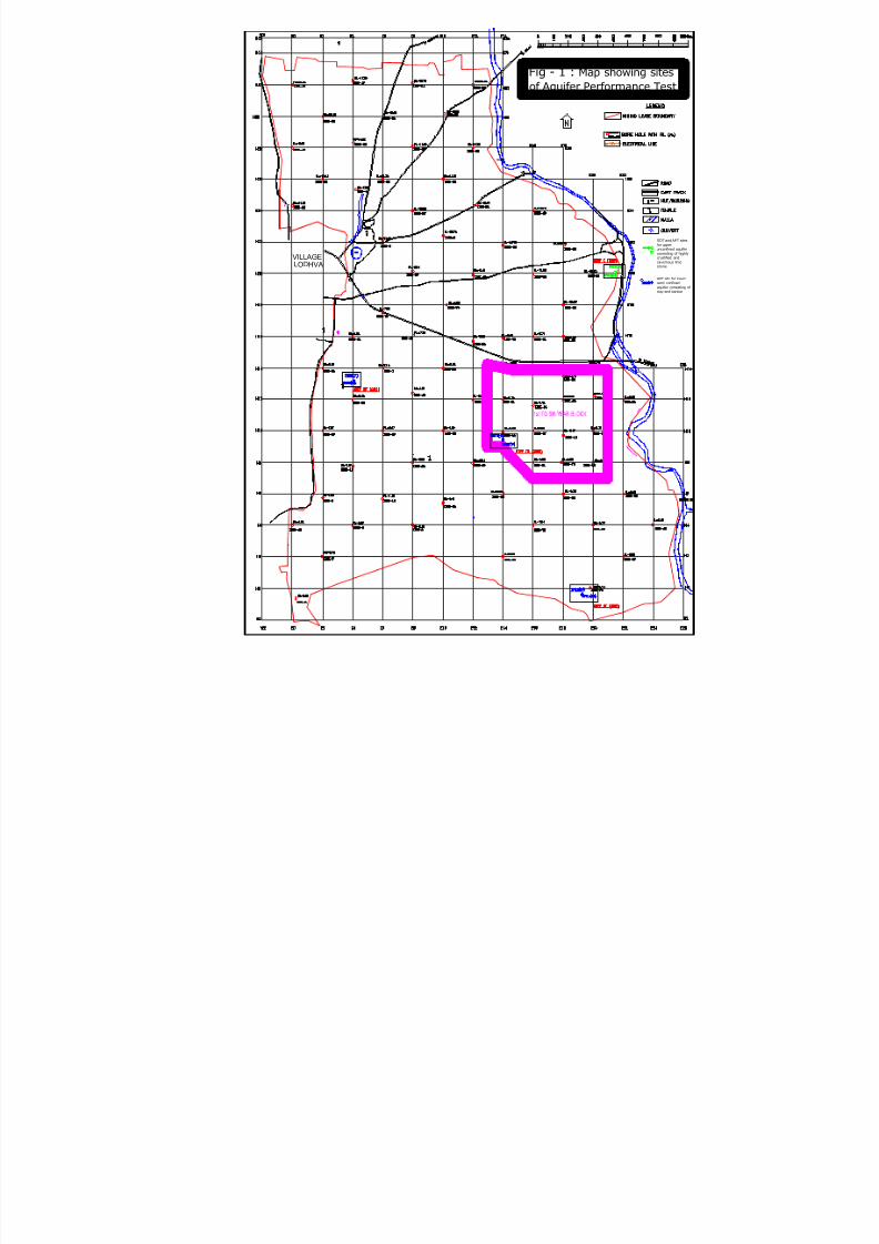
Aquifer erformance Test Aquifer erformance Test
This test is carried out on existing tubewell or new tubewell
along with nearby tubewell in the zone of influence. The test is
conducted by pumping one well continuously for 72 hrs. and
recording periodic changes in water levels in the form of graph
by deploying water level recorder . Using well hydraulic
equations, aquifer parameters like transmissivity, hydraulic
conductivity (movement of water in subsurface through one
cubic meter of aquifer), storage coefficient (storativity) are
determined: which are used in computing total groundwater
recharge into the aquifer systems and is a major component to
estimate annual water availability in the form of dynamic
reserves.
8/8/2019 Ground-water Management Solutions for Industries-2008
http://slidepdf.com/reader/full/ground-water-management-solutions-for-industries-2008 18/65

8/8/2019 Ground-water Management Solutions for Industries-2008
http://slidepdf.com/reader/full/ground-water-management-solutions-for-industries-2008 19/65
Figure - 28
Aquifer Prforme nce Test
Time - Drawdown curve for Obser vation well
Location- 459, Near Grid N10E14 (Set - 3,Lodhva)
0
0.005
0.01
0.015
0.02
0.025
0.03
0.035
0.04
0.045
1 10 100 1000 10000
Time in minutes Since pumping started
D r a w d o w n i n m e t e r s
INDEX :
Field data
Best Fit Curve
Jacob's traight line
(s = .0125
Recharge Boundry
t0 = 1min.
For third segment
Transmissiv ity = T = 2.3 Q (Here Q=1200m
3
/day4 T( s (s = .0125)
= 2.3 x 1200
4 x 3.14 x .0125
pecific Yield
y = 2.25 T t0
r 2
= 2.25 x 17579.61 x .00069
(7.5) 2
= 27.29

8/8/2019 Ground-water Management Solutions for Industries-2008
http://slidepdf.com/reader/full/ground-water-management-solutions-for-industries-2008 20/65
III CONSTRUCTION OF SCIENTIFIC TUBEWELLS SUSTAINABLE IN LONG TERM
Tubewells are constructed scientifically both in alluvial areas and hard rockareas. The design of well is finalized after electrical logging of borehole for
proper delineation of aquifer position in subsurface. In alluvial/ sandy area,irect Rotary rilling Rig is deployed to construct the bore -hole. Followingsteps are necessary in construction of tubewell.
(A) Tubewell in Alluvial Area
Following steps are involved:
(1) iameter of bore-hole
(2) roper ilot Borehole rilling (3) lectrical ogging
(4) Reaming of bore-holes
(5) Installation of well Assembly ± Type of casing (pipes)
± iameter of Casing
± Well Screen length (Slotted ipes) ± Screen size (Slot size)
Filter pack (Gravel packing)
Development of tubewells

8/8/2019 Ground-water Management Solutions for Industries-2008
http://slidepdf.com/reader/full/ground-water-management-solutions-for-industries-2008 21/65
Tubewell in Hard Rock AreaTubewell in Hard Rock Area
In order to utilize water available in hard rock aquifers, down the holehammer rig is deployed capable of drilling in hard rock with diameter
ranging between 6´ to 10´ upto a depth of 800ft.
In the over burden (Loose formation), pilot hole drilling is done using
pilot bits of higher diameter compared to rock drilling diameter for inserting the casing pipe. The casing pipe should have enough strength
and as such, at least µB¶ class category should be used. Normally, casing
pipes with slightly oversize, than the diameter of drilling in rock is kept.
The pipe should be firmly placed in rock equivalent to at least 10% of thetotal length of casing.
In rock, Tungsten carbide button bits are used of the required diameter of
the borehole.
Drilling in rock is not cased and as such, pipes are not to be inserted in
rocky portion of the drilling.

8/8/2019 Ground-water Management Solutions for Industries-2008
http://slidepdf.com/reader/full/ground-water-management-solutions-for-industries-2008 22/65
Tube well in Combination StrataTube well in Combination Strata
There are areas where both alluvium and thelower portion of hard rock contains water.In
such areas, tubwells are constructed deploying
both Direct Rotary drilling rig and Down the hole
hammer rig. These tubewells require combined
methodology of construction as spelt separately
both for alluvial and hard rock area. Fig. depicts
design of such tubewell.

8/8/2019 Ground-water Management Solutions for Industries-2008
http://slidepdf.com/reader/full/ground-water-management-solutions-for-industries-2008 23/65
M.S.plainpipe for
first pump position
Fig.2, Strata chart & design of Exploratory TubeWell Assembly near pumphouse,
Village Aswari,HZL
Gravel packing with
back washing
M.S. Stainer Pipe
with1.5mm opening
M.S. PlainPipeD e p t h i nm t r s . (
b . g.l . ) ---->
60
45
50
55
38.6237.62
35
40
3m.
7.5"
30
25
10
20
15
5
0
W.L. W.L.
Assembly
8"
14"
Boulders & pebbles of Quartzite with cavities
5
Back filled loose material due to high
pressure of water from cavities
Sand mixed with Quartzitic boulders
Pebbles & boulders of Quartzitic rockBoulders of coarse grained Quartzitic rock
Fine grained Quartzite boulders
Boulders & pebbles of Quartzite with voids
Fine grained Quartzitic boulders with
weathered & fractured rock
Coarse grained boulders pebbles with cavities
Hard rock comprising of massive Gneiss rock
Gneiss rock with bouldary bed
Boulders & pebbles of Gneiss & Qurtzitic rock
Boulders & pebbles with cavernous zone
Exclusive well defined cavityBoulders & pebbles with voids
Hard rock of massive nature
Weathered Gneiss with greater degree of
fracturing & voids
D e p t h i nm t r s . (
b . g.l . ) ---->
35
40
45
50
55
60 0
Scale :- 0
0
5
10
20
15
30
25
W.L. W.L.
Lithology LEGENDS :-
Vertical(in mtrs.)10 12
GWMICC(P)LTD.
Horizontal(in inches)4 8
8/8/2019 Ground-water Management Solutions for Industries-2008
http://slidepdf.com/reader/full/ground-water-management-solutions-for-industries-2008 24/65
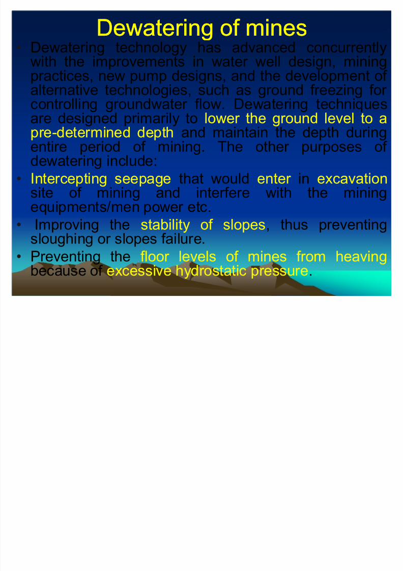
Dewatering of minesDewatering of mines Dewatering technology has advanced concurrently
with the improvements in water well design, miningpractices, new pump designs, and the development of alternative technologies, such as ground freezing for controlling groundwater flow. Dewatering techniquesare designed primarily to lower the ground level to apre-determined depth and maintain the depth duringentire period of mining. The other purposes of dewatering include:
Intercepting seepage that would enter in excavationsite of mining and interfere with the mining
equipments/men power etc. Improving the stability of slopes, thus preventing
sloughing or slopes failure.
Preventing the floor levels of mines from heavingbecause of excessive hydrostatic pressure.
8/8/2019 Ground-water Management Solutions for Industries-2008
http://slidepdf.com/reader/full/ground-water-management-solutions-for-industries-2008 25/65

8/8/2019 Ground-water Management Solutions for Industries-2008
http://slidepdf.com/reader/full/ground-water-management-solutions-for-industries-2008 26/65

8/8/2019 Ground-water Management Solutions for Industries-2008
http://slidepdf.com/reader/full/ground-water-management-solutions-for-industries-2008 27/65

8/8/2019 Ground-water Management Solutions for Industries-2008
http://slidepdf.com/reader/full/ground-water-management-solutions-for-industries-2008 28/65
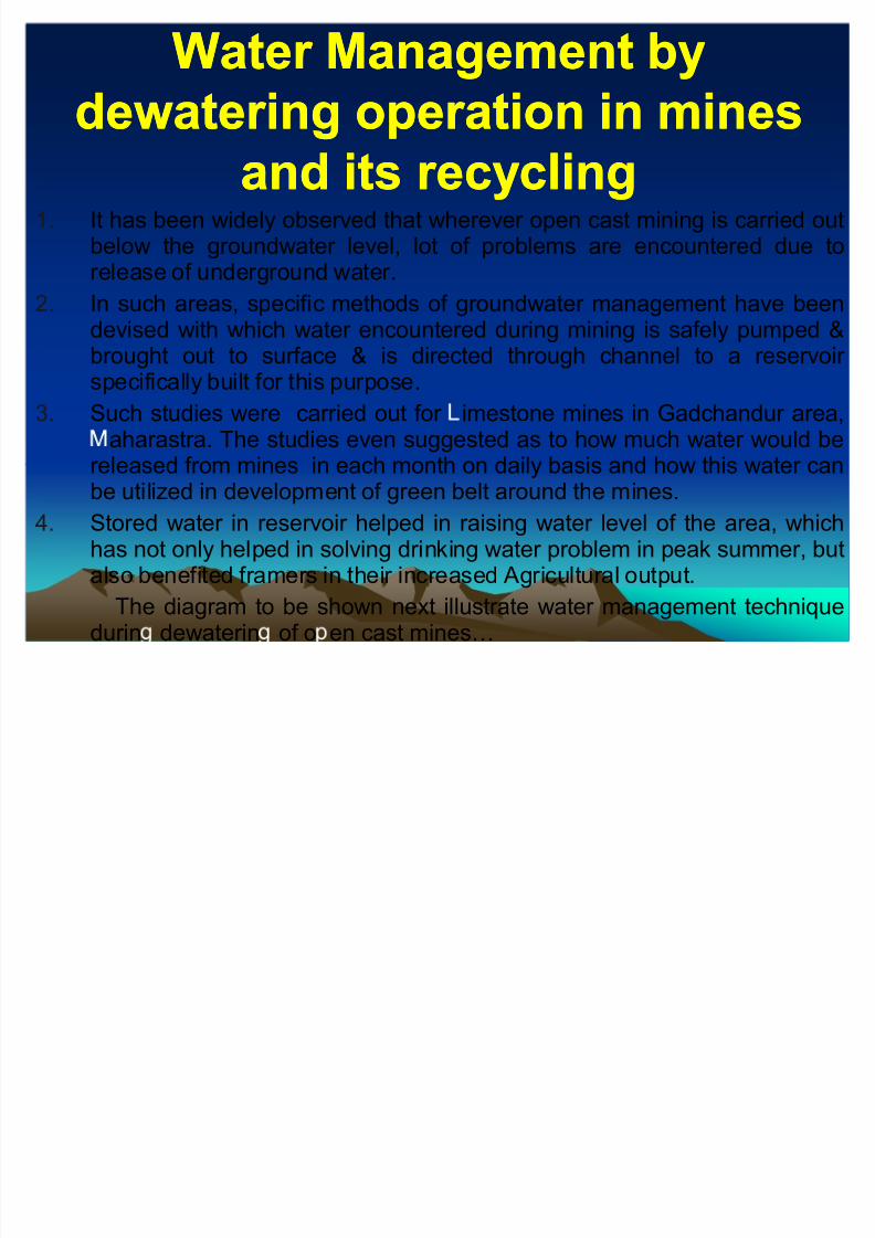
THREE THREE -- DIMENSIONAL COMPUTERIZED SIMULATION AND DIMENSIONAL COMPUTERIZED SIMULATION AND
CONCEPTUAL VISUALIZATION OF GROUND WATER REGIMECONCEPTUAL VISUALIZATION OF GROUND WATER REGIME
Computerized simulation through 3D solid models : Mining of saturatedearth material require better understanding of the functioning of groundwater reservoir in response to natural and man made changes in the system.The complex problem related to functioning of groundwater systems can besolved with the aid of models that simulate the response of the groundwater system. This leads to characterization of the hydro geological units of theaquifers. The results of which has been a three dimensional (3D) trulyintegrated solid model that represents the geometry, interrelationships,hydrostratigraphy, water flow, quantities of water to be dewatered andnumbers of pumps required for dewatering with respect to time. Thecomputer simulation provides powerful visualization tool that will providefield conditions governing the groundwater regime as mining proceedsstarting from the first year itself.
Three D simulations of the different blocks of five year mining areas depict
the details of the thickness, depth, lateral extent, stratigraphy,sedimentology of aquifers and aquicludes, various mining slices, variables of groundwater occurrence presenting the most complete picture of thesubsurface groundwater as representation of reality that presently exists andon internally consistent and directly interpretable conceptual model. The 3Dhydrogeological model that has been developed for this project is anintegrated solid model that represents the ability to receive water from the
recharge area.

8/8/2019 Ground-water Management Solutions for Industries-2008
http://slidepdf.com/reader/full/ground-water-management-solutions-for-industries-2008 29/65
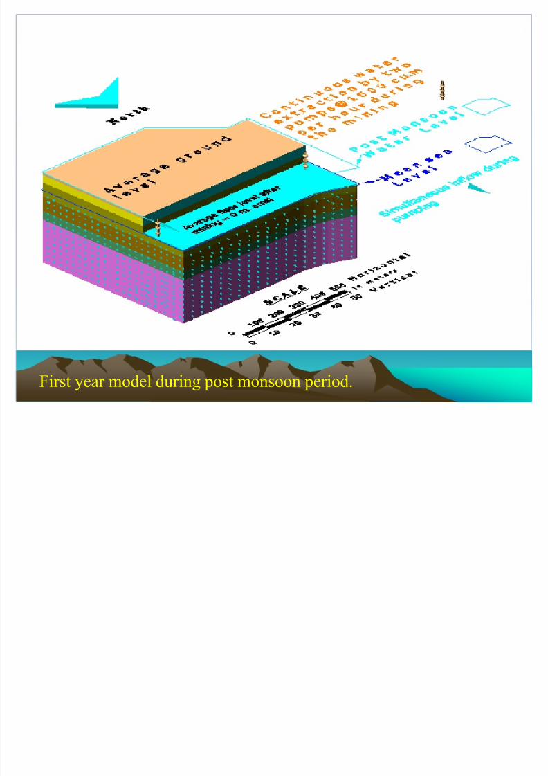
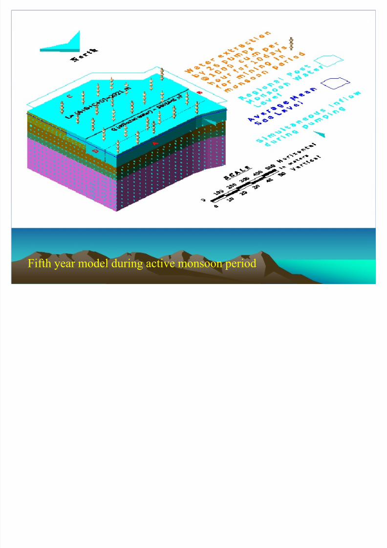
Using mathematical modeling conceptual three dimensional visualization
of ground water regime is depicted in next few slides with effects of
dewatering.
First year Pre-Monsoon period.

8/8/2019 Ground-water Management Solutions for Industries-2008
http://slidepdf.com/reader/full/ground-water-management-solutions-for-industries-2008 30/65
8/8/2019 Ground-water Management Solutions for Industries-2008
http://slidepdf.com/reader/full/ground-water-management-solutions-for-industries-2008 31/65
First year model during post monsoon period.
8/8/2019 Ground-water Management Solutions for Industries-2008
http://slidepdf.com/reader/full/ground-water-management-solutions-for-industries-2008 32/65
Fifth year model during active monsoon period

8/8/2019 Ground-water Management Solutions for Industries-2008
http://slidepdf.com/reader/full/ground-water-management-solutions-for-industries-2008 33/65

8/8/2019 Ground-water Management Solutions for Industries-2008
http://slidepdf.com/reader/full/ground-water-management-solutions-for-industries-2008 34/65
8/8/2019 Ground-water Management Solutions for Industries-2008
http://slidepdf.com/reader/full/ground-water-management-solutions-for-industries-2008 35/65
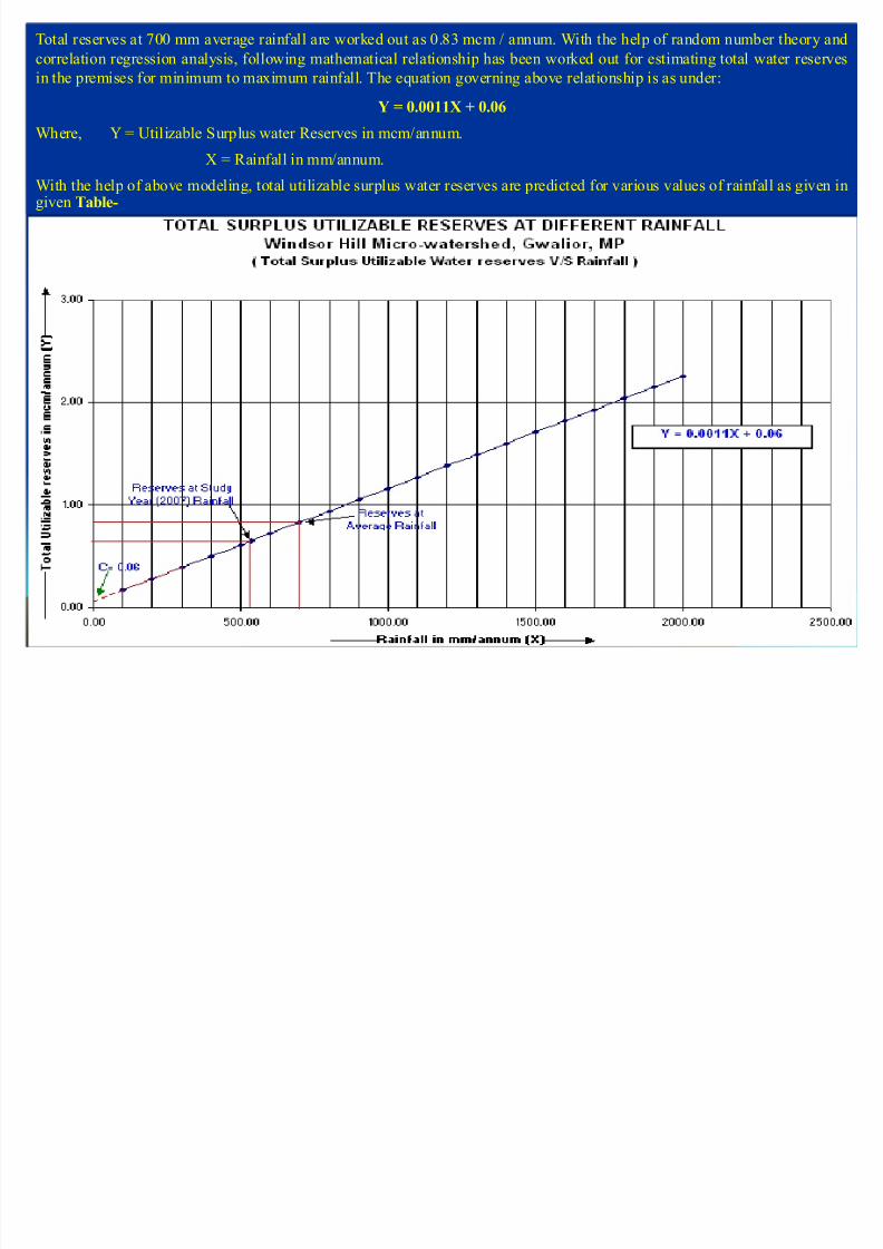
Total reserves at 700 mm average rainfall are worked out as 0.83 mcm / annum. With the help of random number theory and
correlation regression analysis, following mathematical relationship has been worked out for estimating total water reserves
in the premises for minimum to maximum rainfall. The equation governing above relationship is as under:
Y = 0.0011X + 0.06
Where, Y = Utilizable Surplus water Reserves in mcm/annum.
X = Rainfall in mm/annum.
With the help of above modeling, total utilizable surplus water reserves are predicted for various values of rainfall as given ingiven Table-

8/8/2019 Ground-water Management Solutions for Industries-2008
http://slidepdf.com/reader/full/ground-water-management-solutions-for-industries-2008 36/65
RIVER WATER POTENTIA ITY ST DIES
CASE ST DY ± 1 (M.P.)
MAP SHOWING LOCATION OF SUB-SURFACE WATER STUDY SITES & BLA POWER PLANT SITE,VILLAGE NIWARI,NARSINGHPUR, M.P.
8/8/2019 Ground-water Management Solutions for Industries-2008
http://slidepdf.com/reader/full/ground-water-management-solutions-for-industries-2008 37/65
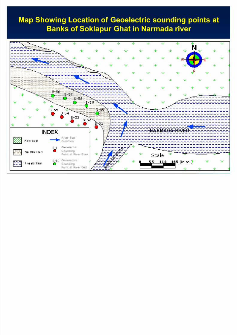
Map Showing Location of Geoelectric sounding points at
Banks of Soklapur Ghat in Narmada river

8/8/2019 Ground-water Management Solutions for Industries-2008
http://slidepdf.com/reader/full/ground-water-management-solutions-for-industries-2008 38/65
Map Showing Location of Surface water flow measurement
points in upstream & downstream at Soklapur Ghat in
Narmada river
8/8/2019 Ground-water Management Solutions for Industries-2008
http://slidepdf.com/reader/full/ground-water-management-solutions-for-industries-2008 39/65
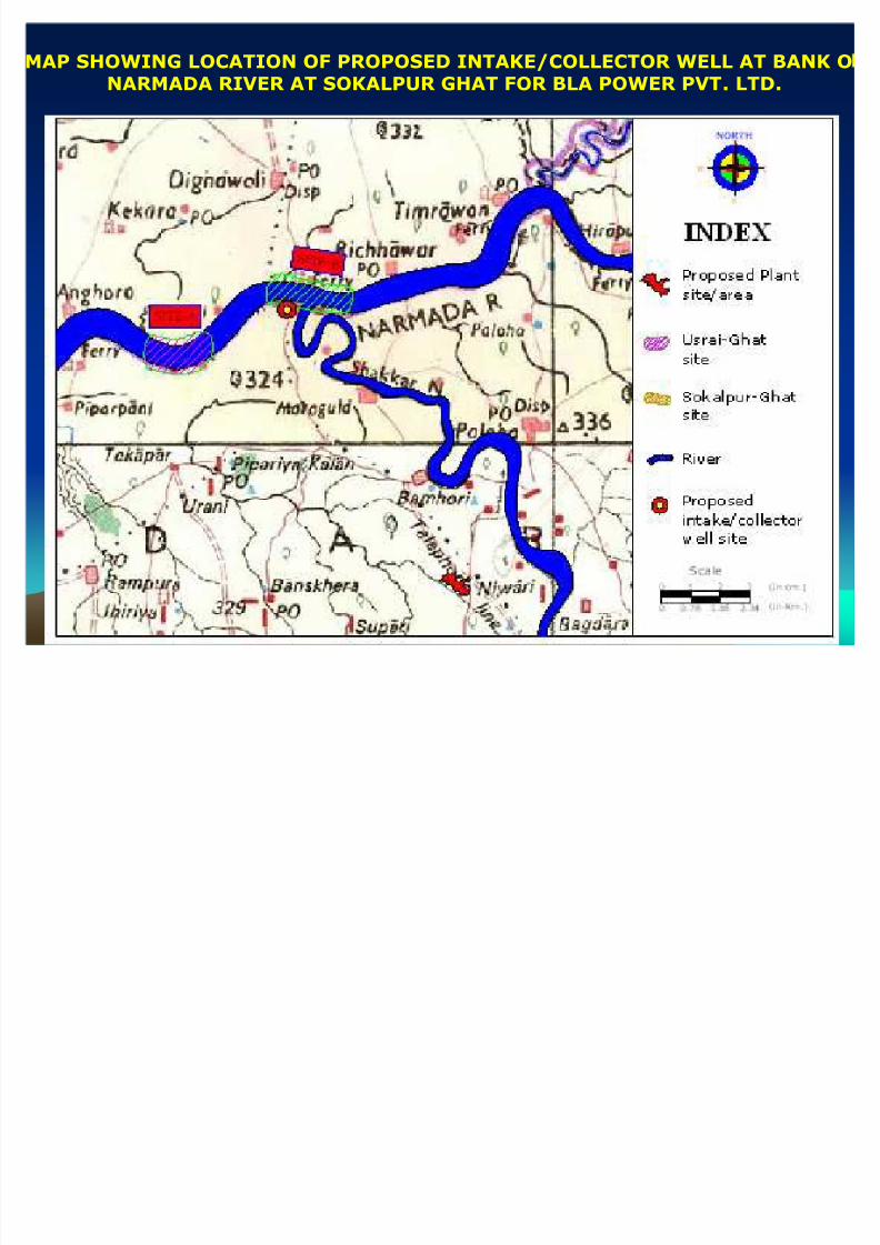
MAP SHOWING LOCATION OF PROPOSED INTAKE/COLLECTOR WELL AT BANK O
NARMADA RIVER AT SOKALPUR GHAT FOR BLA POWER PVT. LTD.
8/8/2019 Ground-water Management Solutions for Industries-2008
http://slidepdf.com/reader/full/ground-water-management-solutions-for-industries-2008 40/65
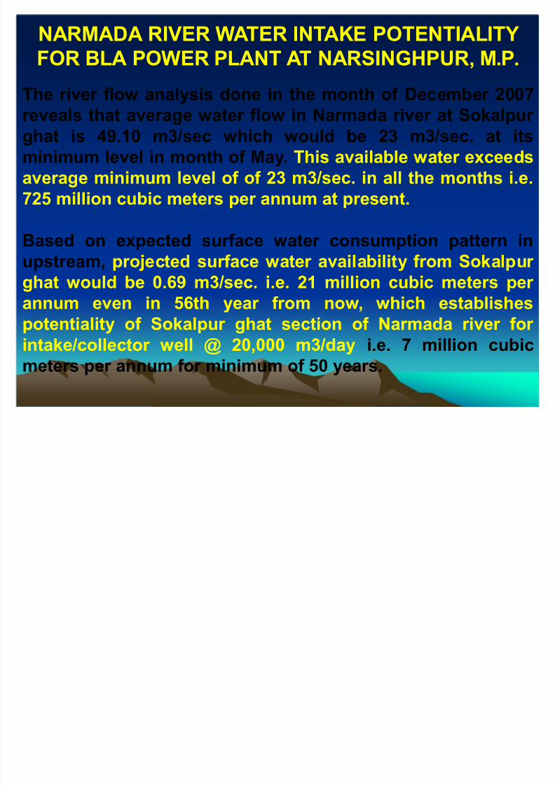
The river flow analysis done in the month of December 2007reveals that average water flow in Narmada river at Sokalpur
ghat is 49.10 m3/sec which would be 23 m3/sec. at its
minimum level in month of May. This available water exceeds
average minimum level of of 23 m3/sec. in all the months i.e.
725 million cubic meters per annum at present.
Based on expected surface water consumption pattern in
upstream, projected surface water availability from Sokalpur
ghat would be 0.69 m3/sec. i.e. 21 million cubic meters per
annum even in 56th year from now, which establishes
potentiality of Sokalpur ghat section of Narmada river for
intake/collector well @ 20,000 m3/day i.e. 7 million cubic
meters per annum for minimum of 50 years.
NARMADA RIVER WATER INTAKE POTENTIALITY
FOR BLA POWER PLANT AT NARSINGHPUR, M.P.

8/8/2019 Ground-water Management Solutions for Industries-2008
http://slidepdf.com/reader/full/ground-water-management-solutions-for-industries-2008 41/65

8/8/2019 Ground-water Management Solutions for Industries-2008
http://slidepdf.com/reader/full/ground-water-management-solutions-for-industries-2008 42/65
RIVER POTENTIALITY STUDIES FOR SURFACE WATER INTAKE
CASE STUDY ±II (M YSORE, KARNATAKA)

8/8/2019 Ground-water Management Solutions for Industries-2008
http://slidepdf.com/reader/full/ground-water-management-solutions-for-industries-2008 43/65

8/8/2019 Ground-water Management Solutions for Industries-2008
http://slidepdf.com/reader/full/ground-water-management-solutions-for-industries-2008 44/65
Rainwater harvesting structures were suggested and implemented atmany places in such a way that 76% of total rainfall over the roof isdirectly added to groundwater through filtration tanks.
1. Few organizations /institutions benefited from the above water harvesting technique include Ambuja Cements, Hero Honda Ltd.,
Sab-Millar Ltd., Vatika Group, Ansal Township, Prism Cement,Unitech Builders, Kalptaru Power Projects, Otsuka chemicals etc.Schematic diagram is shown in the figure to be followed.
The practice helped in reversing the declining trends of water levelsin these areas.
Rainwater harvesting as a technique of water conservation has beenalso implemented at Rotary bhawan, Jaipur in 2003.
Water management through rainwater harvesting

8/8/2019 Ground-water Management Solutions for Industries-2008
http://slidepdf.com/reader/full/ground-water-management-solutions-for-industries-2008 45/65
Rechar e Test l t at er a t rs t ., Dar hera
Recharge test data
(Time V/S Head plot)
0 . 0 0
2 . 0 0
4 . 0 0
6 . 0 0
8 . 0 0
10. 00
12. 00
14. 00
16. 00
1 10 10 0 10 0 0
T i m e i n m i n .a f t e r w a t e r i n j e c t i on - - - - - - - - - >

8/8/2019 Ground-water Management Solutions for Industries-2008
http://slidepdf.com/reader/full/ground-water-management-solutions-for-industries-2008 46/65
CASE HISTORY-2
RAINWATER HARVESTING IN IOCL-SMPL
PROJECT,CHAKSU,JAIPUR.
% 6
% 6
% 6
% 6
% 6 % 6
G EO- ELE C TR I C S O
ND I NG POI NT
Rain waterHa rvesting areas
TA NK
DRA INS
SPOT LE VEL
WA LL
FA NCI NG
FI PE LINE
TB M -1 O N CA N TEE N FLOOR RL=307.05
LEGEND
R W H - 1
R W H - 2
R W H - 1

8/8/2019 Ground-water Management Solutions for Industries-2008
http://slidepdf.com/reader/full/ground-water-management-solutions-for-industries-2008 47/65
STORM WATER MANAGEMENT STORM WATER MANAGEMENT
PROJECT ON ROTARY MARG, JAIPURPROJECT ON ROTARY MARG, JAIPUR
8/8/2019 Ground-water Management Solutions for Industries-2008
http://slidepdf.com/reader/full/ground-water-management-solutions-for-industries-2008 48/65
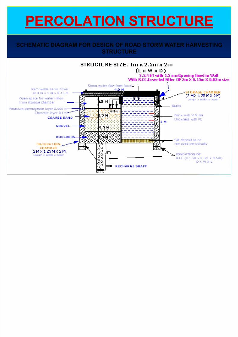
PERCOLATION STRUCTUREPERCOLATION STRUCTURE
SCHEMATIC DIAGRAM FOR DESIGN OF ROAD STORM WATER HARVESTING STRUCTURE
RESERVIOR AS A RESULT OF OPEN AREARESERVIOR AS A RESULT OF OPEN AREA

8/8/2019 Ground-water Management Solutions for Industries-2008
http://slidepdf.com/reader/full/ground-water-management-solutions-for-industries-2008 49/65
RESERVIOR AS A RESULT OF OPEN AREARESERVIOR AS A RESULT OF OPEN AREA
RAINWATER HARVESTING FOR HERO HOND RAINWATER HARVESTING FOR HERO HOND
MOTORS LTD., HARIDWARMOTORS LTD., HARIDWAR

8/8/2019 Ground-water Management Solutions for Industries-2008
http://slidepdf.com/reader/full/ground-water-management-solutions-for-industries-2008 50/65
WASTE WATER RECHARGEWASTE WATER RECHARGE
Infiltration recharge system offer the
additional advantage that the vadose zone
act as natural filter which removes
pollutants and impurities from water as it
moves down to the ground water.
Water for well recharge usually must meet
Drinking water quality standards ,whereas
water for infiltration recharge system may
be of lower quality.
WASTE WATER RECHARGE STUDIES AT GSK

8/8/2019 Ground-water Management Solutions for Industries-2008
http://slidepdf.com/reader/full/ground-water-management-solutions-for-industries-2008 51/65
WASTE WATER RECHARGE STUDIES AT GSK
NABHA, PUNJAB

8/8/2019 Ground-water Management Solutions for Industries-2008
http://slidepdf.com/reader/full/ground-water-management-solutions-for-industries-2008 52/65
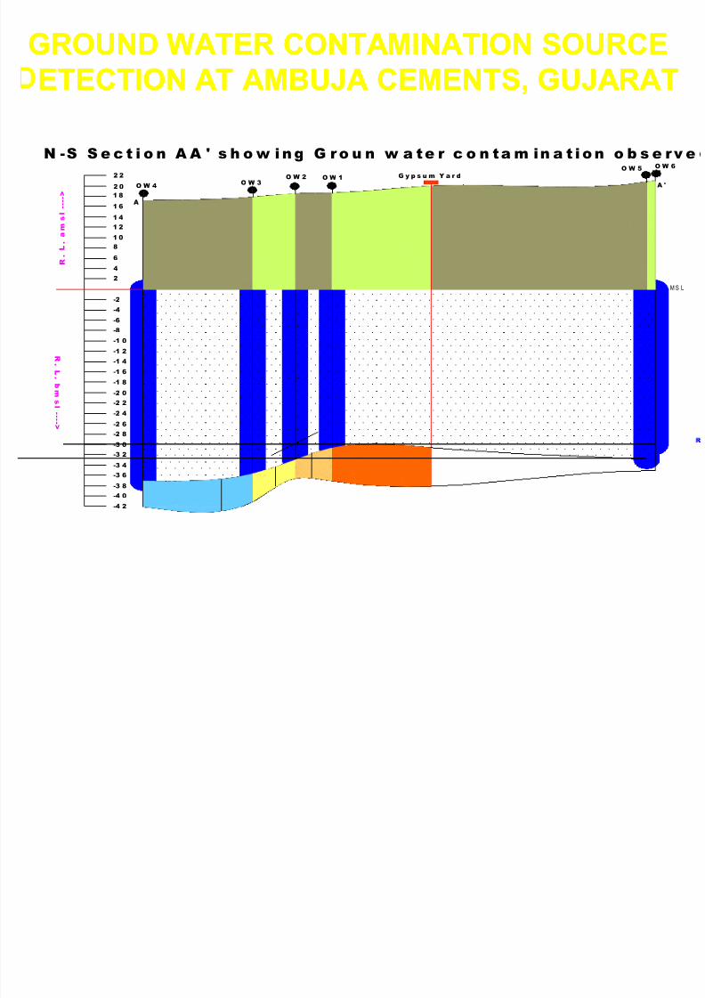
DETECTION OF SOURCE OF GROUND WATER DETECTION OF SOURCE OF GROUND WATER
CONTAMINATION AT AMBUJA CEMENTS, GUJARATCONTAMINATION AT AMBUJA CEMENTS, GUJARAT
C
O N
V E Y
O R
B E
L T
C O N V E Y O R
B E L T
R.F 5000 : 1
8/8/2019 Ground-water Management Solutions for Industries-2008
http://slidepdf.com/reader/full/ground-water-management-solutions-for-industries-2008 53/65
W t ti b j tiW t ti b j ti

8/8/2019 Ground-water Management Solutions for Industries-2008
http://slidepdf.com/reader/full/ground-water-management-solutions-for-industries-2008 54/65
Water conservation by conjunctive useWater conservation by conjunctive use
of surface and ground water of surface and ground water
1. One of the recent studies carried out in Ganganagar district opens thescope of use of canal water in conjunction with brackish ground water.
2. The various combinations of fresh canal water & the brackish groundwater come under the human tolerance limits. This practice decreases load ontotal dependence on the canal water & there by widens the network of thebeneficiaries.
3. Besides, it would partially solve the problem of water logging due tocontinuous seepage from canal to groundwater & almost negligible use of groundwater.
4. The findings can be implemented in whole of Ghaggar basin of NorthernRajasthan, where acute water logging problem has rendered the landinfertile and rising trend of water level would be dangerous to the extent of
land subsidence of villages falling in Ghaggar basin.5. The study was financed by Kalptaru Power Transmission Ltd.
6. The reservoirs created from rainwater harvesting havegood quality of water which can be blended with inferior ground water quality to make it fit for various purposeslike domestic , industrial & other uses
8/8/2019 Ground-water Management Solutions for Industries-2008
http://slidepdf.com/reader/full/ground-water-management-solutions-for-industries-2008 55/65

8/8/2019 Ground-water Management Solutions for Industries-2008
http://slidepdf.com/reader/full/ground-water-management-solutions-for-industries-2008 56/65
OTHER PROBLEMS
&
SOLUTIONS
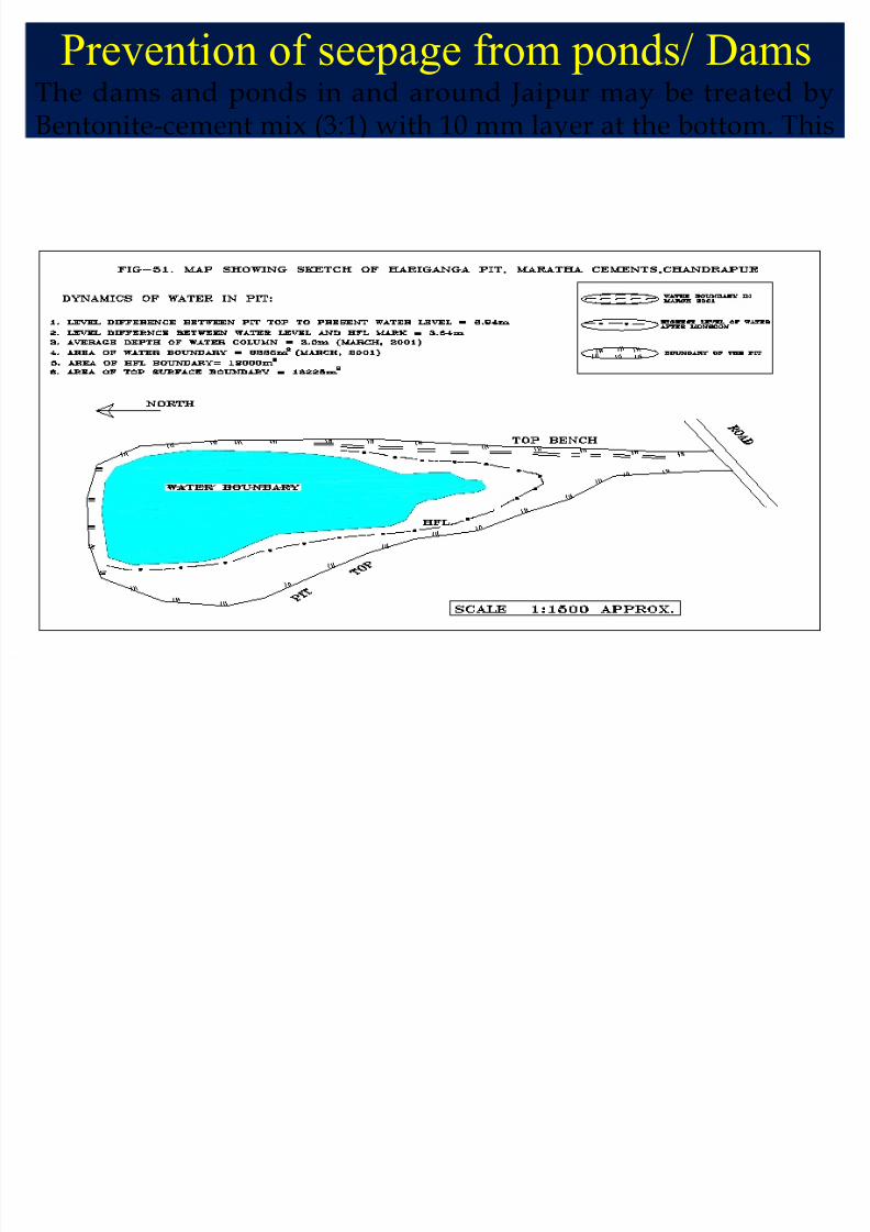
Prevention of seepage from ponds/ Dams
8/8/2019 Ground-water Management Solutions for Industries-2008
http://slidepdf.com/reader/full/ground-water-management-solutions-for-industries-2008 57/65
Prevention of seepage from ponds/ DamsThe dams and ponds in and around Jaipur may be treated byBentonite-cement mix (3:1) with 10 mm layer at the bottom. This
would help in checking the seepage loss up to 70%. Similarly, wecan prevent 60% water loss due to evaporation by growing Lillyflowers in the ponds.

8/8/2019 Ground-water Management Solutions for Industries-2008
http://slidepdf.com/reader/full/ground-water-management-solutions-for-industries-2008 58/65
Defunct hand pumps :
The defunct hand pumps found any where may be linked withnatural drainage through filtration tank to send the runoff waterin to the ground water regime.
C ll ti R i W t H ti

8/8/2019 Ground-water Management Solutions for Industries-2008
http://slidepdf.com/reader/full/ground-water-management-solutions-for-industries-2008 59/65
Government should make it essential gradient of its water policythat all house complexes, colonies developed by the housingboard, Avas Vikas Sansthan, Municipal Corporations ,Development authorities etc. should adopt rain water harvestingin a group scheme.
Collective Rain Water Harvesting
P l ti it th d
8/8/2019 Ground-water Management Solutions for Industries-2008
http://slidepdf.com/reader/full/ground-water-management-solutions-for-industries-2008 60/65
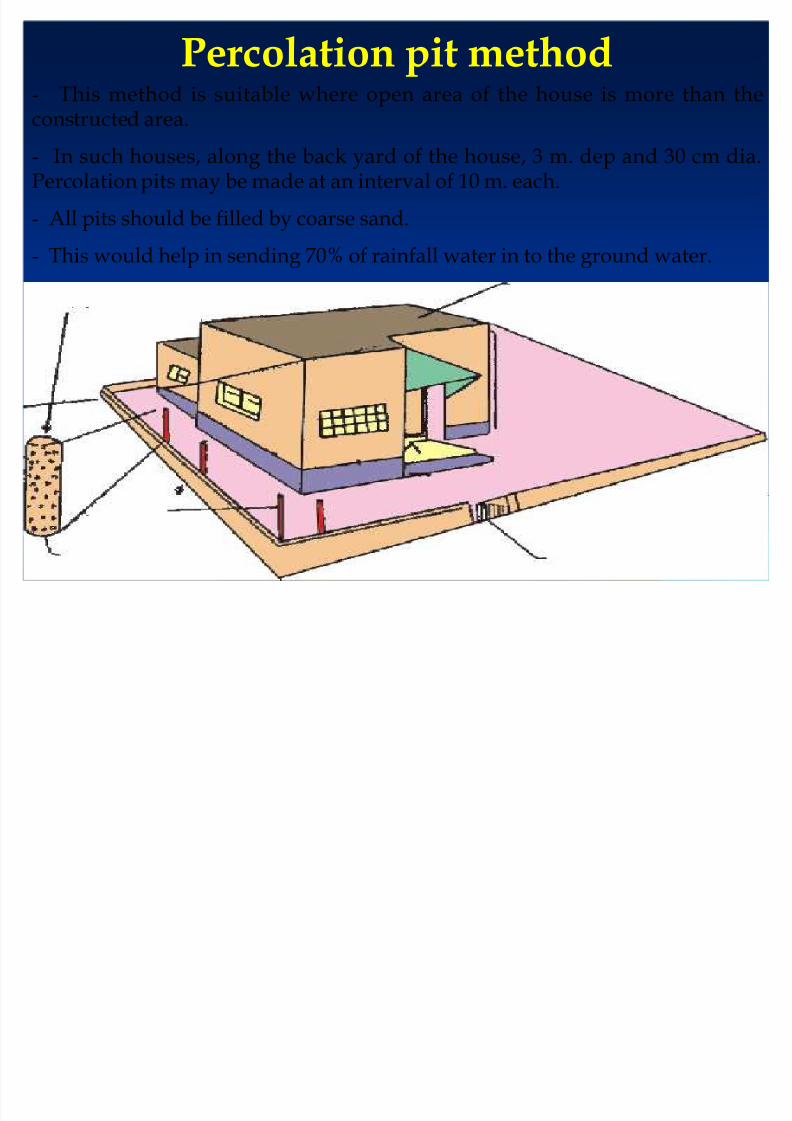
Percolation pit method- This method is suitable where open area of the house is more than theconstructed area.
- In such houses, along the back yard of the house, 3 m. dep and 30 cm dia.Percolation pits may be made at an interval of 10 m. each.
- All pits should be filled by coarse sand.
- This would help in sending 70% of rainfall water in to the ground water.
8/8/2019 Ground-water Management Solutions for Industries-2008
http://slidepdf.com/reader/full/ground-water-management-solutions-for-industries-2008 61/65
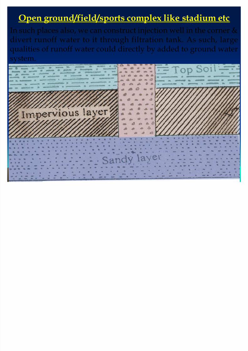
Open ground/field/sports complex like stadium etc
In such places also, we can construct injection well in the corner &divert runoff water to it through filtration tank. As such, largequalities of runoff water could directly by added to ground watersystem.
Wise use of waterWise use of water

8/8/2019 Ground-water Management Solutions for Industries-2008
http://slidepdf.com/reader/full/ground-water-management-solutions-for-industries-2008 62/65
Wise use of water Wise use of water
Pipe leakage should be monitored and controlled
to prevent wastage of water. People using small pumps on water lines should be punished.Polymer pipes should be used for water supply.
A chapter on the right use of water should beincluded in school textbooks. Children should betrained by the teachers for right use of water.
Government should bring water legislation to
prevent construction of new bore wells/tube wellswithout permission of state water regulatoryauthority.
A ff ti bli i i d d t

8/8/2019 Ground-water Management Solutions for Industries-2008
http://slidepdf.com/reader/full/ground-water-management-solutions-for-industries-2008 63/65
An effective public campaign is needed to
encourage people to save water.
Use of adjustable cistern system in toilets
should be preferred instead of flush
system
Recycling of waste water should be
adopted.
House wives should be specificallytrained for water conservation in all
routine, domestic needs.
Benefits of water Management Conservation and Rain
8/8/2019 Ground-water Management Solutions for Industries-2008
http://slidepdf.com/reader/full/ground-water-management-solutions-for-industries-2008 64/65
Benefits of water Management ,Conservation and Rain
Water Harvesting
To avoid depletion of groundwater level, the aquifers must be recharged in every possible manner. There is an urgent need for harvesting every drop of rain water andavoid wastage.
1. We as concerned citizens must follow methods of water conservation at individuallevel, motivate others & help in as many water conservation projects as possible andcreate public awareness at wide scale.
2. From all possible platforms, we should also impress upon the government to
implement community based water conservation programmers as already spelt.
Role of IndustriesRole of Industries
The groundwater level is raised due to recharging of underground water
regime. Dilutes the salt content in wells and improves the water quality.
Improves moisture content in the soil.
Adds to the growth of plants & trees.
Sea water intrusion into the land is arrested.
The water would be available adequately to large population .

8/8/2019 Ground-water Management Solutions for Industries-2008
http://slidepdf.com/reader/full/ground-water-management-solutions-for-industries-2008 65/65
A very Big Thank you to all
With the expectation that each one of youBecome concern person for water management, Rain
Water Harvesting and conservative Utilization of water
Resources from this very moment.