ground water information booklet …cgwb.gov.in/district_profile/hp/kinnaur.pdf · subdivided into...
TRANSCRIPT
जल संरषण व्ष 2013
Series-E For official use only
Government of India
Ministry of Water Resources
CENTRAL GROUND WATER BOARD
GROUND WATER INFORMATION BOOKLET
KINNAUR DISTRICT, HIMACHAL PRADESH
NORTHERN HIMALAYAN REGION
DHARAMSALA
September, 2013

GROUND WATER INFORMATION BOOKLET
Kinnaur District, Himachal Pradesh
CONTENTS
DISTRICT AT A GLANCE
Page No.
1.0 INTRODUCTION
1
2.0 RAINFALL & CLIMATE
2
3.0 GEOMORPHOLOGY & SOIL TYPES
2
4.0 GROUND WATER SCENARIO
4.1 Hydrogeology 5
4.2 Ground Water Resources 7
4.3 Ground Water Quality 7
4.4 Status of Ground Water Development 9
5.0 GROUND WATER MANAGEMENT STRATEGY
5.1 Ground Water Development 9
5.2 Water Conservation & Artificial Recharge 11
6.0 GROUND WATER RELATED ISSUES & PROBLEMS
11
7.0 AWARENESS & TRAINING ACTIVITY 11
8.0 AREAS NOTIFIED BY CGWA / SGWA 12
9.0 RECOMMENDATIONS 12

KINNAUR DISTRICT AT A GLANCE
Sl. No ITEMS Statistics
1. GENERAL INFORMATION
i) Geographical area (sq km) 6401
ii) Administrative Divisions (2001)
• Number of Tehsil & Sub-tehsils
• Number of CD Blocks
• Number of Panchayats
• Number of Villages
5 & 1
3
65
660
iii) Population (2011 Census)
• Total population
• Population Density (pers/sq km)
• Rural & Urban Population
• SC & ST Population (in percent)
• Sex Ratio
84,121 persons
13
100 % & 0 %
17.5 % & 58 %
819
iv) Average Annual Rainfall (mm) 816 mm
2. GEOMORPHOLOGY
Major Physiographic units • High Hill Ranges
• Valleys
General Altitude Range 1500 to >6000 m amsl
Major Drainages
• Satluj Basin
• Ganga Basin
Baspa R., Spiti R. Bhaba R.
Chor Khad.
3. LAND USE (2003-04) sq.km
• Forest area
• Cultivated Area
• Net area sown
1,754
104
857
4. MAJOR SOIL TYPES • Mountainous Soil
• Sub-Mountainous Soil
5.
IRRIGATION BY DIFFERENT SOURCES
(MI census 2000-02) (sq km)
Dug wells & shallow TW
Surface Flow Irrigation Schemes
Surface Flow Irrigation Schemes
Tanks
No/Scheme Area (sq km)
Nil Nil
235 77.86
Nil Nil
Nil Nil
6. NUMBER OF GROUND WATER
MONITORING WELLS OF CGWB
(As on 31.3.2013)
• No. of Dug Wells
• No. of Piezometers
Nil
Nil

7. PREDOMINANT GEOLOGICAL
FORMATIONS
• Alluvium
• Older Crystalline /
Sedimentary /
Metamorphic rocks
8. HYDROGEOLOGY
Major Water Bearing Formations
1. Consolidated sediments / Hard Rocks
(Older crystalline & Metamorphics)
Covering major part
• Yield prospects
• GW structures
Low (<5 lps)
Handpumps & Springs
2. Unconsolidated / Semi-consolidated
sediments
Valley areas
• Yield prospects
• GW structures
Moderate to High (5-15 lps)
Handpumps & Springs
Avg. Depth to water level (shallow bore well) 10-30 m bgl
9. GROUND WATER EXPLORATION BY CGWB
(As on 31.3.2013)
• No of wells drilled Nil
• Depth Range (m) --
• Discharge (lps) --
• Transmissivity (m2/day) --
10. GROUND WATER QUALITY
Presence of Chemical constituents more than
permissible limits
(eg. EC, F, As, Fe)
Nil
11. DYNAMIC GROUND WATER RESOURCES
(2011)
Not estimated due to localized
aquifers.
12. AWARENESS AND TRAINING ACTIVITY
Mass Awareness Programmes
• Place / Date / No of participants
Nil
• Water Management Training Programmes Nil
• Place / Date / No of participants Nil
13. EFFORTS OF ARTIFICIAL RECHARGE &
RAINWATER HARVESTING
Nil
14. GROUND WATER CONTROL AND
REGULATION
Number of OE Blocks Nil
No of Critical Blocks Nil
No of blocks notified Nil
15. MAJOR GROUND WATER PROBLEMS AND
ISSUES
1. Water scarcity in low
rainfall area.
2. Effects of various
hydroelectric projects
on traditional sources.
1 | P a g e
GROUND WATER INFORMATION BOOKLET KINNAUR DISTRICT, HIMACHAL PRADESH
1.0 INTRODUCTION
Kinnaur district is located in eastern part of Himachal Pradesh. The district is entirely hilly
except few small, deep valleys in between. The district, with its headquarter at Recong
Peo, lies between 31° 06’ & 32° 06’ North latitudes and 77° 45’& 79° 00’ East longitudes.
The district is covered by Survey of India degree-sheet no 53I, 53E and 52L. The district is
bounded by Lahaul & Spiti district in the north, Tibet (China) in the east, Uttranchal State
in the south, Shimla in the southwestern part and Kulu in the northwest.
The district has a total geographical area of 6,401 sq km, covers 11.5 % area of the State
and ranks 3rd
in the State. The district is divided into five tehsils and one sub-tehsil. The
five tehsils are Nichar, Kapla, Sangla, Pooh and Moorang. The only sub-tehsil in the
district is Hangrang. There are 660 villages in the district, of which 234 villages are
inhabited and 426 are uninhabited. For development purpose, the district has been
subdivided into 3 Community Development Blocks viz. Nichar, Kalpa and Pooh.
As per 2011 census, the district has a population of 84,121 persons with population density
of 13 persons per sq. km. Population wise it ranks 11th
in the State. The district is having
100% rural population. The sex ratio of the district is 819. The schedule cast population in
the district is 17.5 % and the schedule tribe population is 58 %.
The major sources of irritation are small water channels or the Kuhls, in the district and an
area of 77.86 sq km is brought under irrigation by surface water sources like, major khads
and nallahs. A sizeable part of the cultivated area of the district, is not having assured
irrigation facilities and the agriculturists have to depend on the vagaries of weather. Under
various plans, the construction of kuhls and lift irrigation schemes are being taken up in the
district.
CGWB has carried out hydrogeological studies, both by conventional and non-
conventional methods in the district. The area has not been covered so far either, under
Ground water exploration programme or under the ground water regime monitoring.

2 | P a g e
3 | P a g e
2.0 CLIMATE & RAINFALL
The variance of climate, is as varied as the area. One experiences change, from the heat of
the tropical zone, almost to the freezing temperature of a lowland winter. In the outer
Himalayas, which is partly under the influence of the periodical rain, the temperature is
much more uniform than in the interior, where, the summer is sultry and the winter
extremely cold at elevation of from 8000 to 10,000 feet, in favorable situations, such as
Chango, Leo, and Moorang the temperature of July and August is 20° to 22° C and in
October temperature is about 10° C. At and elevation of 12,000 feet the summer
temperature is between 13° C to 18° C and in October it is 3° to 4°C. In summers it is
fairly warm in lower hills. The winter is often rigorous, and in some parts people do not
venture out of their homes because of heavy snow. The mean monthly temperature, varies
from 5° C to 23° C.
The district receives rainfall from the month of June till September. The marginal shift in
the monsoon pattern has ben noticed over the period of years. The average annual rainfall
in the district is 816 mm. However much of the rainfall is received in parts of lower
Kinnaur. There is a progressive decrease in rainfall as one goes from west to east. The
parts of upper Kinnaur receive more snowfall than the rainfall.
The district receives heavy snowfall from November end or early December till March or
sometimes April. During this period, the area remains totally cutoff from rest of the area.
The higher peaks of Kinnaur district are completely covered with snow throughout the
year.
3.0 GEOMORPHOLOGY & SOIL TYPES
Kinnaur district presents an intricate mosaic of mountain ranges, hills and deep valleys. It
is primarily a hilly district, with altitudes ranging from 1,500 m to more than 6,500 m asl.
There is a general increase in elevation, from west to east and from south to north. Master
slope is south-westerly. The drainage system of the district forms a part of the Indus River
basin, except a small part in the northeastern area, which is apart of the Ganga River
system. Geomorphologically, the district has been sub divided into the fluvial terrain,
fluvio-glacial terrain, Alpines / meadows and Rocky terrain
Taking into consideration, the morphological and physio-chemical characteristics of the
soils and general similarity in them, the various types of soils observed in the district can
be grouped into three major types viz Type-I, Type-II& Type-III. Type-I soil is coarse
loamy, mixed in nature. The soil is developed from granites, highly metamorphosed
gneisses, schists and occurs on moderately sloping to steep lands. These soils are well
drained, with moderately rapid permeability. Natural vegetation exists in these soils and
various crops are cultivated according to the suitability.

4 | P a g e

5 | P a g e
Type-II soil is fine loamy, mixed, frigid in nature. They have developed on parent material
consisting of granite-gneiss and mica schists, on steep to very steep slopes at an altitude of
>3000 m amsl. These are grazing lands supporting alpine grasses. Type- III soil includes
various series like Sangla, Spilo, Kalpa, Leo, Rocky I, Rcky II and Scree series.
4.0 GROUND WATER SCENARIO
4.1 Hydrogeology
The rock formations occupying the district range from pre-Cambrian to Quaternary period.
The generalized geological succession in the district is given below
Age / Period Group / formation Lithology
Quaternary Alluvium, Terrace &
Fluvial deposits
Alluvium, clay, sand, gravel, pebbles,
boulders and cobbles
Tertiary Nako Granitoid Granitoids
Mesozoic Giumal – Chikkim
Spiti formation,
Lilang Group
Shales Sandstone, Siltstone
Carbonate rich sedimentary rocks
Palaeozoic Kuling Group
Kunzamla, Thango,
Takche formation
Sandstones, shales, conglomerates
Proterozoic Batal formation
Salkhala, Kulu, Jutogh
Vaikrita, Rampur Group,
Bandal Wangtu Gneissic
Complex
Slates, phyllites, quartzites and
schists, Amphibolites, Gneisses,
granites, Pegmatites
The hydrogeological framework of the district is essentially controlled by geological
setting, distribution of rainfall / snowfall and movement of water through inter-connected
primary and secondary porosities of the geological formations, constituting the aquifers.
Based on the geological diversities and relative ground water potentialities of different
geological formations, the district can be divided broadly into two hydrogeological units
viz. Porous Formations comprising unconsolidated sediments and the Fissured
Formations comprising hard rocks.

6 | P a g e

7 | P a g e
The Porous Formations comprise of quaternary sediments. These sediments are fluviatile
deposits, occurring along the Baspa River, Ropa Gad, Taiti Gad, Wenger Gad, Tidong Gad
in the lower reaches and in the upper reaches generally underlain by glacio-fluviatile
deposits. These are deposited as narrow elongated stripes, valley fills within the hard rock
terrain. These form a potential aquifers. The thickness of these deposits, may be more
along the soft rock formations or in structurally weak zones. Along the Baspa River in
Sangla valley, about 40 sq.km and along Ropa River valley, 7 sq. km area is ground water
worthy, with expected thickness of 20 to 30 m below Riverbed. However, there are other
numerous isolated small valley fills, which are also ground water worthy.
Fissured formations are constituted by hard rock formations, belonging to crystalline
rocks. Jutogh / Vaikritas Rampur group, Giumal and Chikkim formations. These rock
formations consist of granites, gneisses, slates, pegmatites, phyllites, schists, quartzites,
limestones, sandstone, shales, conglomerates and boulder beds. These rocks are generally,
massive and devoid of primary porosity. However, due to the tectonic activities, secondary
porosity has developed along fracture / joints and fault zones. Weathered zone, rarely form
an aquifer because of the little thickness of the weathered mantle, due to the topographical
slope in the area.
In hard rock terrain in district Kinnaur, the ground water is distributed either along
structurally weak / fractured zones, faults and land slides zones or along the contacts of the
different rock formation in the topographically favorable areas. In the Satluj River valley,
the areas around Taranda, Tapri, between Oling and Lipa, Moorang and Tabling are most
promising for Exploration. The other ground water potential areas are along Baspa River,
Tidong Gad, Taiti Gad and Spiti River. The occurrence of the large numbers of springs in
these zones, are indicative of existence of these zones.
4.2 Ground Water Resources
Rainfall is the major source of groundwater recharge, apart from the influent seepage from
the rivers, irrigated fields and inflow from upland areas, whereas, discharge from ground
water mainly takes place from effluent seepages of ground water, in the form of springs
and base flow in streams etc.
The district has a hilly terrain, having very high slopes. The valley areas are deep, narrow
and isolated. The area therefore is not considered for estimation of the ground water
resources, being discontinuous aquifers.
4.3 Ground Water Quality
National Hydrograph Network Stations have not been established in the district so far.
However, the water samples were collected form various sources like spring and
handpumps during the various hydrogeological studies, which reveal that revels that the
overall ground water quality is good and is suitable for all type of uses.

8 | P a g e
9 | P a g e
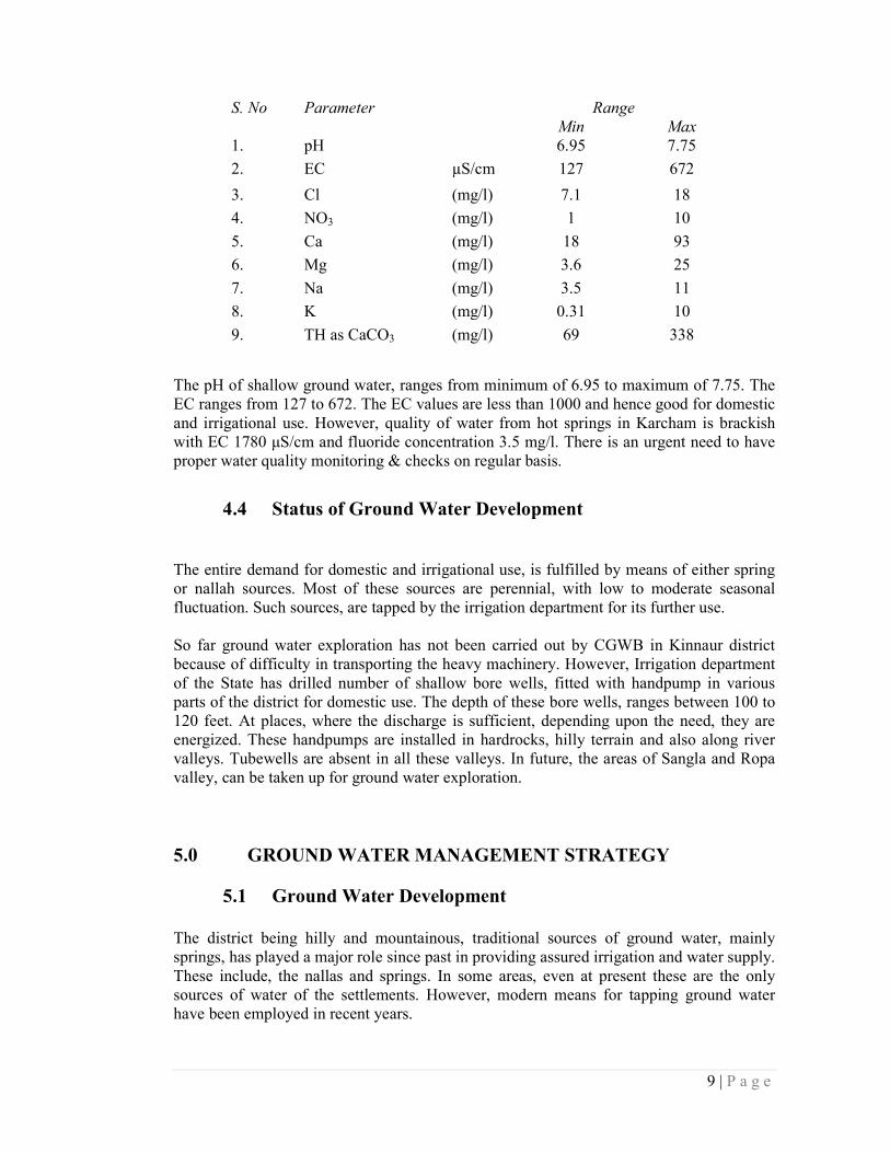
S. No Parameter Range
Min Max
1. pH 6.95 7.75
2. EC µS/cm 127 672
3. Cl (mg/l) 7.1 18
4. NO3 (mg/l) 1 10
5. Ca (mg/l) 18 93
6. Mg (mg/l) 3.6 25
7. Na (mg/l) 3.5 11
8. K (mg/l) 0.31 10
9. TH as CaCO3 (mg/l) 69 338
The pH of shallow ground water, ranges from minimum of 6.95 to maximum of 7.75. The
EC ranges from 127 to 672. The EC values are less than 1000 and hence good for domestic
and irrigational use. However, quality of water from hot springs in Karcham is brackish
with EC 1780 µS/cm and fluoride concentration 3.5 mg/l. There is an urgent need to have
proper water quality monitoring & checks on regular basis.
4.4 Status of Ground Water Development
The entire demand for domestic and irrigational use, is fulfilled by means of either spring
or nallah sources. Most of these sources are perennial, with low to moderate seasonal
fluctuation. Such sources, are tapped by the irrigation department for its further use.
So far ground water exploration has not been carried out by CGWB in Kinnaur district
because of difficulty in transporting the heavy machinery. However, Irrigation department
of the State has drilled number of shallow bore wells, fitted with handpump in various
parts of the district for domestic use. The depth of these bore wells, ranges between 100 to
120 feet. At places, where the discharge is sufficient, depending upon the need, they are
energized. These handpumps are installed in hardrocks, hilly terrain and also along river
valleys. Tubewells are absent in all these valleys. In future, the areas of Sangla and Ropa
valley, can be taken up for ground water exploration.
5.0 GROUND WATER MANAGEMENT STRATEGY
5.1 Ground Water Development
The district being hilly and mountainous, traditional sources of ground water, mainly
springs, has played a major role since past in providing assured irrigation and water supply.
These include, the nallas and springs. In some areas, even at present these are the only
sources of water of the settlements. However, modern means for tapping ground water
have been employed in recent years.
10 | P a g e
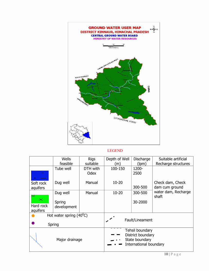
Wells
feasible
Rigs
suitable
Depth of Well
(m)
Discharge
(lpm)
Suitable artificial
Recharge structures
Soft rock
aquifers
Tube well
Dug well
DTH with Odex
Manual
100-150
10-20
1200-2500
300-500
Check dam, Check dam cum ground
water dam, Recharge shaft
Hard rock
aquifers
Dug well
Spring
development
Manual 10-20 300-500
30-2000
( Hot water spring (400C)
• Spring
Fault/Lineament
Major drainage
Tehsil boundary
District boundary State boundary International boundary
LEGEND

11 | P a g e
During the last 15-20 years, Irrigation and Public Health Department has constructed
number of small depth bore wells, fitted with handpumps in these areas. High hill ranges
occupy more than 95 % of area of the district. During the past years, traditional ground
water source has served the settlements. Ground water development on small scale is seen
in the valley areas, particularly in the Baspa valley. Handpumps have been installed in
these areas and are energized for water supply. There exists, a scope to explore the ground
water potential in remaining low lying valley areas. The area of the district is feasible only
for drilling shallow to medium depth bore wells.
5.2 Water Conservation & Artificial Recharge
Ground water extraction through springs and hand pumps are the major sources of water
supply, but the availability of water during summer is limited particularly in lean periods
and requires immediate attention to augment the ground water resource. Based upon the
climatic conditions, topography, hydro-geology of the area, suitable structure for rain water
harvesting and artificial recharge to ground water are required. Proper scientific
intervention for spring development and revival is required in water scarce areas. In the
hilly areas, roof top rainwater harvesting structures like storage tanks are recommended
while in low hill ranges, check dam and roof top rainwater harvesting structures can be
adopted.
6.0 GROUND WATER RELATED ISSUES & PROBLEMS
The district being hilly and mountainous, most of the rainfall goes waste as runoff. This
has resulted in varying degree of recharge to the ground water. In such hard rock terrain,
since the aquifers are discontinuous and of different geological/hydrogeological setup, the
ground water scenarios are different in various parts of the districts.
Most of the ground water issues and problems so far noted in the district are localized and
need to be treated independently by taking micro level studies in a particular area. Some of
the common issues are deeper water level because of the terrain and hydrogeological setup,
effects of various hydroelectric projects on the traditional water sources like springs as
noticed in the Nichar area of the district.
7.0 AWARENESS & TRAINING ACTIVITY
Mass Awareness Programme (MAP) & Water Management Training
Programme (WMTP) by CGWB
Mass Awareness Programme/Water Management Training Programme have been
conducted in the district and Water Management Training Programme has been recognized
at Bed. College & Sr. Sec School Ponda, Tehsil Nichar and Reckong Peo.

12 | P a g e
Participation in Exhibition, Mela, Fair etc
CGWB has not participated in exhibition, Melas so far.
Presentation & Lectures delivered in public forum / Radio/TV/Institution
of repute/Grassroots association /NGO/Academic institutions etc
So far presentation and lectures were delivered amongst the gathering during the MAP and
WMTP only.
8.0 AREAS NOTIFIED BY CGWA / SGWA
None of the areas of the district are notified by CGWA / SGWA.
9.0 RECOMMENDATIONS
� In valley areas, in addition to traditional ground water structures like springs,
shallow to medium depth tube wells can be constructed for developing the ground
water resource.
� In hilly terrain, springs and perennial nallas are the major sources of water. Shallow
to medium depth bore wells fitted with hand pump are useful ground water
structures for meeting the domestic needs and are feasible at favorable areas.
� Traditional resources like springs needs to be revived, developed & protected on
scientific lines for various use. The discharge of such springs can be sustained by
construction of small check dams or subsurface dykes across the nallahs/tributaries
in the downstream at favorable locations.
� Small ponds/tanks/talavs can be utilized for recharging ground water. These
structures can be constructed for harvesting water and may be utilized for both
recharging and meeting the domestic needs.
� Roof top rainwater harvesting practices must be adopted in hilly areas since the
district receives ample rainfall. Because of hilly terrain, maximum rainfall goes of
as runoff, and a very small quantity contributes towards ground water
replenishment.
� Rainwater harvesting in general & Roof Top Rain Water Harvesting in particular is
an ideal solution for augmenting water resources particularly in sloppy hilly &
chronic water scarce areas. There is thus need to create awareness for water
conservation, augmentation and proper waste disposal for protecting water sources
� People’s participation is a must for any type of developmental activities. So they
should be made aware for proper utilization and conservation of water resources
available. In addition, micro level efforts are required for proper implementation of
development programme.
SAVE WATER SAVE WATER SAVE WATER SAVE WATER –––– SAVE LIFESAVE LIFESAVE LIFESAVE LIFE

जल संर�ण वष� 2013
Contributors
Vidya Nand Negi
Scientist-C
Prepared under the guidance of
J.S. Sharma Regional Director Incharge
and
Dalel Singh
Suptdg Hydrologist
Our Vision
Water security through sound groundwater management

जल संर�ण वष� 2013
For Technical Assistance Relating to
Rainwater Harvesting
&
Artificial Recharge to Ground Water
Contact:
CENTRAL GROUND WATER BOARD NORTHERN HIMALAYAN REGION
Dove Cottage, Near Ramnagar, Dharmsala
District Kangra, (H.P.)
Phone: 01892- 224775, 227160
Telefax: 01892-223535
e-mail: [email protected]
website: www.cgwb.gov.in
SAVE WATER SERVE HUMANITY