ground water in the san jaginto and temegula …san jacinto peak, 10,805 feet above the sea. san...
TRANSCRIPT
DEPARTMENT OF THE INTERIORFRANKLIN K. LANE, Secretary
UNITED STATES GEOLOGICAL SURVEYGEORGE OTIS SMITH, Director
Water-Supply Paper 429
GROUND WATER IN THE SAN JAGINTOAND TEMEGULA BASINS,
CALIFORNIA
BY
GERALD A. WARING
Prepared in cooperation with the
DEPARTMENT OF ENGINEERING OP THE STATE OP CALIFORNIA
WASHINGTONGOVERNMENT PRINTING OFFICE
1919

CONTENTS.
Page.Introduction.............................................................. 7San Jacinto basin.......................................................... 7
General features....................................................... 7Geography....................................................... 7Geology.......................................................... 9Climate.......................................................... 10Settlement and industries........................................... 14
Irrigation systems...................................................... 16Lake Hemet Water Co............................................. 16Fairvie-w Land & Water Co........................................ 18Citizens Water Co................................................. 18Lakeview Water Co................................................ 19Perris and Alessandro irrigation districts.............................. 19
Ground water........................................................ £0Source of supply.................................................... 20Quality of water................................................... 21
Description by areas.................................................... 23San Jacinto area................................................... 23
Location and character........................................ 23Hot springs.................................................... 24Artesian area.................................................. 27Ground-water level............................................ 29Irrigation.. ..................................................... 30Quality of water............................................... 31Alkali.......................................................... 31
Hemet area........................................................ 32Location and character......................................... 32Ground-water level............................................ 32Irrigation...................................................... 36Quality of water............................................... 37Alkali.......................................................... 37
Winchester area.......................................-...."........ 37Location and character........................................ 37Ground-water level........................................... 38Irrigation..................................................... 41Quality of water.............................................. 41Alkali.......................................................... 41
Lakeview area...................................................... ' 42Location and character........................................ 42Artesian areas................................................ 42Ground-water level........................................... 44Irrigation...................................................... 46Quality of water.............................................. 47Alkali......................................................... 47
3
4 CONTENTS.
San Jacinto basin Continued.Description by areas Continued. Page.
Moreno area......................... r ............................ 47Location and character........................................ 47Ground-water level........................................... 48Irrigation..................................................... 50Quality of water.............................................. 50
Perris area........................................................ 50Location and character........................................ 50Ground-water level........................................... 51Irrigation..................................................... 62Quality of water.............................................. 63Alkali......................................................... 64
Menifee area ....................................................... 64Location and character........................................ 64Ground-water level........................................... 65Irrigation..................................................... 68Quality of water.............................................. 69Alkali......................................................... 69
Elsinore Lake area................................................ 69Location and character........................................ 69Geologic features............................................... 70Surface water................................................. 71Hot springs................................................... 75Ground-water level........................................... 75Irrigation..................................................... 76Quality of water.............................................. 78Alkali....................................................... 78
Temescal area..................................................... 79Location and character........................................ 79Hot springs.................................................... 79Artesian area................................................. 80Ground-water level........................................... 80Irrigation..................................................... 80Quality of water.............................................. 81Alkali......................................................... 81
Temecula basin........................................................... 81General features....................................................... 81
Geography....................................................... 81Geology.......................................................... 82Climate.......................................................... 84Settlement and industries.......................................... 84
Surface water......................................................... 85Description by areas................................................... 86
Murrieta Valley................................................... 86Location and character........................................ 86Hot springs................................................... 87Artesian areas................................................ 87Ground-water level........................................... 88Irrigation...................................................... 89Quality of water.............................................. 89Alkali......................................................... 90
CONTENT'S. ' 5
Temecula basin Continued.Description by areas Continued. Page.
Temecula Valley.................................................. 90Location and character........................................ 90Artesian area................................................. 91Ground-water level........................................... 92Irrigation..................................................... 92Quality of water.............................................. 93Alkali......................................................... 93
Pumping tests, by Herman Stabler......................................... 93Notes on the plants.................................................... 93
Tested plants...................................................... 93Untested plants..................................................... 97Pumping station of the Temescal Water Co........................ 97
Summary of tests...................................................... 98Factors affecting costs................................................. 102Selection of machinery................................................ 105
Index.................................................................... Ill
ILLUSTRATIONS.
Page.PLATE I. Sketch map of part of California, showing areas covered by water-
supply papers of the United States Geological Survey.............. 7II. Map of San Jacintoand Temecula basins, showing relief and drainage
basins.......................................................... 8III. Map of San Jacinto and Temecula basins, showing geologic forma
tions, artesian basins, depth to water, and location of wells.. In pocket.IV. A, Eden Hot Springs; S, San Jacinto Valley, looking southward
from Relief Hot Springs....................................... 24V. Map of San Jacinto and Temecula basins showing irrigated lands,
pumping plants, and principal distribution systems.......... In pocket.VI. Map of San Jacinto and Temecula basins showing lands irrigated in
1904 and in 1915... ...............*........................ In pocket.VII. San Jacinto Valley from Park Hill................................. 30
VIII. Logs of wells in the Hemet area................................... 32IX. A, Perris and Alessandro valleys, from point about 2 miles north of
Perris; J3, Hemet irrigated district, from Reservoir Butte.......... 36X. A, Western part of Double Butte, Winchester area, looking toward
Perris; B, Juniper Flat, Lakeview Mountains..................... 38XI. A, San Jacinto River near Perris; B, Land near Perris prepared for
seeding to alfalfa................................................ 51XII. Escarpment along south side of Elsinore Lake..................... 68
XIII. A, Valley of Temecula River; B, Southern part of Elsinore Lakebasin, from slopes northeast of Wildomar........................ 70
XIV. A, Temescal Wash and bench lands below Temescal; B, Benchlands along southwest side of Temescal Wash, below Lee Lake.... 78
6 » CONTENTS.
FIGURE 1. Diagram showing seasonal precipitation at stations in the San Page. Jacinto basin.................................................. 11
2. Diagram showing origin of artesian pressure in the San Jacinto basin. 213. Logs of wells in the San Jacinto area.............................. 264. Diagram showing fluctuation of water level in record wells near
Bowers...................................................... 295. Diagram showing fluctuation of water level in record wells in the
Hemet area................................................... 356. Logs of wells near Winchester................................... 387. Diagram showing fluctuation of water level in record wells near
Winchester.................................................. 408. Logs of flowing artesian wells near Casa Loma.................... 439. Diagram showing fluctuation of water level in record wells near
Lakeview.................................................... 4610. Logs of wells in the Moreno area.................................. 4911. Logs of wells in the Perris area................................... 5212. Diagram showing fluctuation of water level in record wells in the
Perris area................................................... 6113. Log of well in Menifee Valley................................... 6514. Diagram showing fluctuation of water level in record wells in
Menifee Valley............................................... 6815. Logs of flowing artesian wells in Temecula Valley.................. 91
INSERTS.
Mineral analyses, etc., San Jacinto area.................................... 30Mineral analyses, etc., Hemet area........................................ 36Mineral analyses, etc., Winchester, Lakeview, and Moreno areas............ 40Mineral analyses, etc., Perris and Menifee areas............................ 62Mineral analyses, etc., Elsinore Lake and Temescal areas................... 78Mineral analyses, etc., Temecula basin..................................... 86
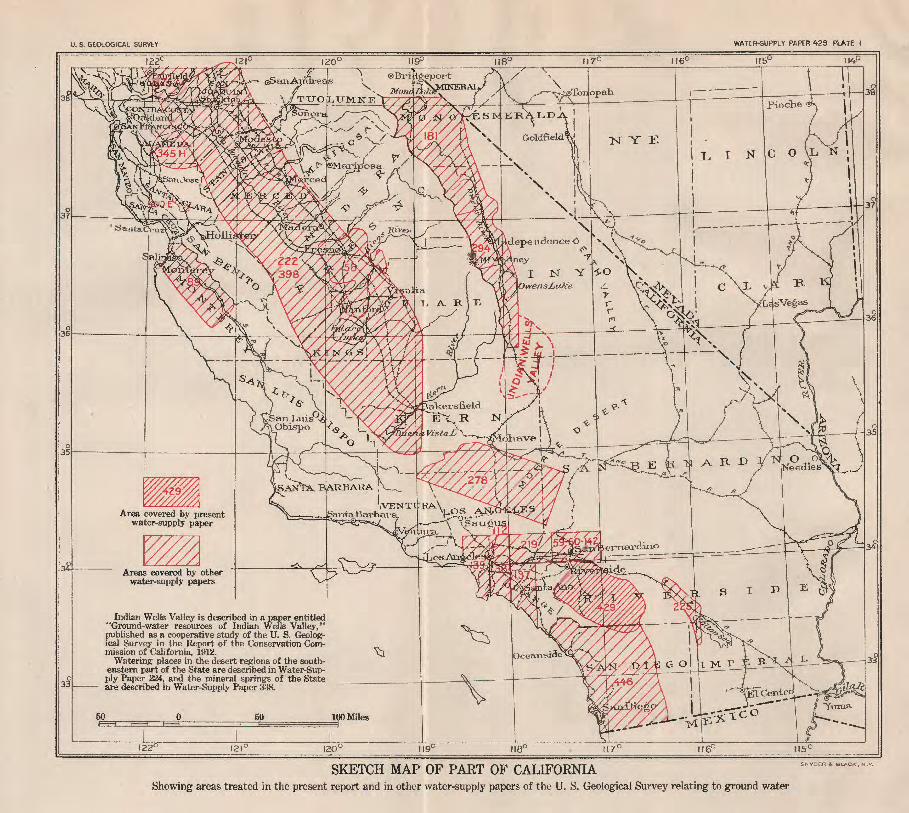
U. S. GEOLOGICAL SURVEY WATER-SUPPLY PAPER 429 PLATE I
TITO^LTJMKE V7
*" iakersueld> *
E
Area covered by present
Areas covered by other water-supply papers
Indian Wells Valley is described in a paper entitled "Ground-water resources of Indian Wells Valley," published as a cooperative study of the U. S. Geolog ical Survey in the Report of the Conservation Com mission of California. 1912.
Watering places in the desert regions of the south eastern part of the State are described in Water-Sup ply Paper 224, and the mineral springs of the State are described in Water-Supply Paper 338.
SKETCH MAP OF PART OF CALIFORNIAShowing areas treated in the present report and in other water-supply papers of the U. S. Geological Survey relating to ground water
GROUND WATER IN THE SAN JACINTO AND TEMECULA BASINS, CALIFORNIA.
By GERALD A. WARING.
INTRODUCTION.
A study of the conditions affecting the occurrence of ground-water in the San Jacinto and Temecula basins in southern California was begun in 1904 by Walter C. Mendenhall, to obtain data for a report on the area similar to reports which he had prepared on other areas in the southern part of the State. 1 A study of the fluctuation of the ground-water level was also begun by measuring the depth to water in certain wells at intervals of a few months. When the well records were collected it was expected that the results of the ground-water study could be prepared for early publication. The unavoidable delay in the preparation of this report has, however, been advanta geous to the study of fluctuations of ground water for it has made the period of collection of records longer than would otherwise have been feasible.
In the fall of 1915 the author spent about six weeks in the San Jacinto and Temecula basins, in bringing up to date the information collected earlier, and in July, 1916, he spent a few days in supple mentary studies in this region. The detailed descriptions of the areas were prepared by the author, but the discussion of the general fea tures and of the irrigation systems of the San Jacinto basin were written by Mr. Mendenhall.
In connection with the studies of fluctuation of ground water tests of pumping plants in the region were made in 1910 by Herman Stabler, whose results are appended to the present report.
SAN JACINTO BASIN.
GENERAL FEATURES.
GEOGEAPHY.
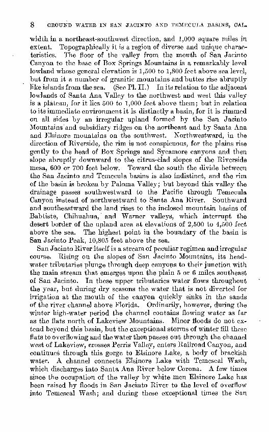
The San Jacinto River basin is in western Riverside County, in southern California. (See PL I.) The basin is irregular in outline, about 65 miles in extreme length, east and west, 30 miles in greatest
i U. S. Geol. Survey Water-Supply Papers 219, 237, 238, 239, 242. See index map, PI. I.
7
8 GROUND WATER IN SAN JACINTO AND TEMECTJLA BASINS, CAL.
width in a northeast-southwest direction, and 1,000 square miles in extent. Topographically it is a region of diverse and unique charac teristics. The floor of the valley from the mouth of San Jacinto Canyon to the base of Box Springs Mountains is a remarkably level lowland whose general elevation is 1,500 to 1,800 feet above sea level, but from it a number of granitic mountains and buttes rise abruptly like islands from the sea. (See PI. II.) In its relation to the adjacent lowlands of Santa Ana Valley to the northwest and west this valley is a plateau, for it lies 500 to 1,000 feet above them; but in relation to its immediate environment it is distinctly a basin, for it is rimmed on all sides by an irregular upland formed by the San Jacinto Mountains and subsidiary ridges on the northeast and by Santa Ana and Elsinore mountains on the southwest. Northwestward, in the direction of Riverside, the rim is not conspicuous, for the plains rise gently to the head of Box Springs and Sycamore canyons and then slope abruptly downward to the citrus-clad slopes of the Riverside mesa, 600 or 700 feet below. Toward the south the divide between the San Jacinto and Temecula basins is also indistinct, and the rim of the basin is broken by Paloma Valley; but beyond this valley the drainage passes southwestward to the Pacific through Temecula Canyon instead of northwestward to Santa Ana River. Southward and southeastward the land rises to the inclosed mountain basins of Babtiste, Chihuahua, and Warner valleys, which interrupt the desert border of the upland area at elevations of 2,500 to 4,500 feet above the sea. The highest point in the boundary of the basin is San Jacinto Peak, 10,805 feet above the sea.
San Jacinto River itself is a stream of peculiar regimen and irregular course. Rising on the slopes of San Jacinto Mountains, its head water tributaries plunge through deep canyons to their junction with the main stream that emerges upon the plain 5 or 6 miles southeast of San Jacinto. In these upper tributaries water flows throughout the year, but during dry seasons the water that is not diverted for irrigation at the mouth of the canyon quickly sinks in the sands of the river channel above Florida. Ordinarily, however, during the winter high-water period the channel contains flowing water as far as the flats north of Lakeview Mountains. Minor floods do not ex tend beyond this basin, but the exceptional storms of winter fill these flats to overflowing and the water then passes out through the channel west of Lakeview, crosses Perris Valley, enters Railroad Canyon, and continues through this gorge to Elsinore Lake, a body of brackish water. A channel connects Elsinore Lake with Temescal Wash, which discharges into Santa Ana River below Corona. A few times since the occupation of the valley by white men Elsinore Lake has been raised by floods in San Jacinto River to the level of overflow into Temescal Wash; and during these exceptional times the San
TJ. S. GEOLOGICAL SURVEY WATER-STJPPLY PAPER 429 PLATE II
MAP OF SAN JACINTO AND TEMECULA BASINS, SHOWING RELIEF AND DRAINAGE BASINS.

SAN JACINTO BASIN. ' 9
Jacinto has been a continuous stream from its source at the base of San Jacinto Peak to its junction with Santa Ana River, through which it discharges into the sea; but under ordinary conditions the waters of the river do not join those of the ocean.
GEOLOGY.
In detail the geology of the San Jacinto basin is complex; but little of the detail bears on the question of water supply, the theme of this paper. It may be said, however, that the basin occupies a depressed crustal block, which is bounded on the northeast and the southwest by faults. One of these faults extends along the northeastern base of Santa Ana and Elsinore mountains, and the valley that marks its position is occupied by Temescal Wash and Elsinore Lake basin. The second noteworthy fault extends northwest and southeast along the southern base of the ridge between the San Jacinto basin and San Timoteo Canyon. Between these lines of dislocation is the San Jacinto basin and on each side of it are the mountain ranges that separate it from adjacent drainage basins. (See PI. II.)
On Christmas morning, 1899, a locally violent earthquake shock resulting from movement along the San Jacinto fault or a related sub sidiary fracture damaged several buildings in the city of San Jacinto. On the adjacent Indian reservation a few lives were lost by the fall of adobe house walls. The geographic limits of the disturbance seem to have been very narrow, apparently because the locus of the dis placement was restricted to the hills back of San Jacinto.
Most of the rocks of the basin are granitic, but to the south, in Diamond and Paloma valleys and in the hills between Elsinore and P 3rris, are masses of contorted black slates and schists, probably of Triassic age. To the northwest, along Temescal Wash, there are un altered sandstones, shales, and clays of Eocene, Miocene, and possibly Pliocene age. (See PL III, in pocket.) To the north the Badlands, between Moreno and San Timoteo Canyon, consist chiefly of partly consolidated gritty clay shales, which are overlain unconformably by gravels that are probably of alluvial origin. Definite evidence as to the age of the shales in these hills is lacking, but because of their re semblance to similar rocks elsewhere in California, it is assumed that they were deposited during the Pliocene epoch. Near and east of Eden Hot Springs these sediments lie unconformably upon ancient granitic and metamorphic rocks, as shown in Plate IV, A. A series that is similar to that of the Badlands forms the lower slopes east of San Jacinto and also the hills between the lower courses of the South Fork of the San Jacinto and Bautista Creek. The isolated masses of Park Hill and Casa Loma Hill are composed of the same partly consolidated materials, but the Lakeview Mountains, the hills between Lakeview and Moreno, and in general the buttes that rise
10 GROUND WATEE IN" SAN JACINTO AND TEMECULA BASIN'S, CAL.
above the floor of the valley consist of older granitic and metamor- phic rocks.
All the rocks thus far described are important in their relation to supplies of ground water only because they furnish a practically water tight bottom and rim for the basin, and because the loose alluvial material brought down by the streams has been deposited and accu mulated in the irregularities of their surfaces. In this alluvial wash, which constitutes the modern valley fill, all the abundant supplies of ground water are found. Wise and effective use of the water de pends on the possibility of recovering it cheaply and at such a rate that the water level will not be drawn down by the pumps and the flowing wells more rapidly than it is restored through absorption of rainfall and of flood waters during each winter.
CLIMATE.
The climate of the San Jacinto basin is typical of the moderately elevated interior basins of southern California. It is characterized by a division of the year into a wet and a dry season, generally low precipitation, large proportion of clear days, moderately high summer temperatures, and absence of low winter temperatures. The aver age seasonal precipitation at San Jacinto is about 13 inches, at Elsi- nore 13^ inches, and at Idyllwild, on the slope of the San Jacinto Mountains at an elevation of 5,250 feet, nearly 28 inches. The avail able monthly records of precipitation at these three stations are given in the following tables, 1 and the seasonal precipitation and its de parture from the average is shown graphically in figure 1. The sea sonal instead of the annual precipitation was used in preparing the diagram, as it represents the total precipitation during each winter, the rainy season extending from about September to May.
Precipitation, in inches, in Riverside County, Cal.
Idyllwild.
[ Elevation 5,250 feet.]
Season.
1901................1901-2..............1902-3. .............1903-4 ..............1904-5..............1905-6..............190&-7. .............1907-8..............1908-9..............1909-10.............1910-11 .............1911................
July.
0.34 .33
0 T. .03 .73 .05
1.50 1.00 .55
1.02
Aug.
3.44 0 .57
2.45 .17
2.77 0 2.73 1.87 .21
0
Sept.
0 T. 2.21 T..38 .14
T. 3.11.40 .15.&0
Oct.
1.03.10 .47 .25
T. .03
4.55 1.85 0 1.43 .43
Nov.
6.69 3.80 0 0 8.38 2.15 1.11 .70
4.34 2.40
.15
Dec.
0.34 2.00 0.98
1.93 5.25 2.64 1.05 8.53 .10
&2.10
Jan.
o3.47 2.42 3.82 .80
6.85 3.34 7.30 3.96
12.18 5.20 9.35
Feb.
5.81 5.25 3.00 2.70 8.43 5.32 2.71 3.85 7.27 .60
6.26
Mar.
1.235.53 6-76 4.59
10.07 16.15 6.78 1.67 4.56 3.08 6.03
Apr.
0.37 .09
6.10 a2.19 2.21 3.19 .89
2.34 .26 .33
1.34
May.
1.22.20 .48
ol.42 3.77 2.73 1.48 1.14 .15
0 0
June.
0 .10 .09
0 0 .04 .43
0 0 0 T.
Sea sonal.
"i9.~43
26.48 14.95 35.01 41.66 30.66 21.31 35.34 25.35 27.82
Year.
ipoi1902 1903 1904 1905 1906 1907 1908 1909 1910 1911
An nual.
17.- 94 19.82 23.50 15.38 42.22 41.84 27.94 23-90 40-54 14.05 25.38
26.60
a Interpolated. 6 Station discontinued.
i U. S. Dept. Agr. Weather Bur. Bull. W, vol. 1,1912, and later date.
SAN JAQIISTTO BASIN". 11
Id/llwiM
SO indies
No record No record
Sa n^aci
No record
Elsinoro
No record
O^ O9 O) o£ O) O^ OT
FIGURE 1. Diagram showing seasonal precipitation at stations in the San Jacinto basin.

12 GBOUND WATER IN SAN JACINTO AND TEMECULA BASINS, OAL.
San Jacinto.
[Elevation 1,550 feet.]
1886................1886-87.............
1892-93.............1893 941894-95.............1895-96.............1896-97.............1897-98.............1898-99.............1899-1900...........1900-01.............1901-02.............1902-03.............1903-04
1905-06.............1906-07.............1907-08.............
1909-10.............1910-11.............
1912-13.............1913-14.............1914-15.............1915-16.............1916................
0.50
0310
T.07
a.08
o,08.01
0.10
000
520
.17
.18000
00
.0?,
.....
0o.asTTo.lO
CA
0
0
,3?
T0
.45OQ
00
,50,40
0.28,70
0,5104
0,40.16
00
.01
.0601.1600
0.45
00
.50000.07
0 69.66.04
T1 763.380
,81
.61
.060
13.24
0S on
910
on00
0no
0i 33
0,7780
0
1 90
.341 0
1.834.57
.061 9t;002 542 43.11
201 70
0.48
9 13
.55
.700
0.17
1.273 165 qfi
.341.70
,471,38
.750T2 1?
1.0?
4 79E7
CO
4 890001 342 CQ
?, 45
4.50.33
2 7167
7 ftl
2.04
2 00
1 4?,2.861 551 39
oa
3 4A
1.425 113 01
3 962 QQ4.71
1 t\
1 07r cc
4.6510,71
1.504.19
1 66,96
1 EQ
3,744969
04 621 C.7
1 37«1 156.481 QQ
2 fio
2 Q9
3 OC
3 1903 503.847 051.36
3 16
6 01QQ
3 702.24
.811 (K
.76,33
2 01
3 fl9
4 gg6 509 QQ
1 613 A4
2 292 317 90
971 03
,21.99
?: 10
3.48
.25
.10
,71a,71a.71
1 97.03.53
OK
1.03.94,04.35
001,393 24
.614 072,130
0,371 1 t\
.262?,
a.67
1 86.55,01
0.15
1,26,57
00
1C.
001.180
.Ofi
.83
.04
000,03000000
.01T000000000
16.25
00
8.67
13.738 QO
16.679.20
15.519.468.409.58
13.40
15.757 on
18.5914.79
12.6713.7612.5215.44
7 9Q18.8717.2616.60
12.95
1886
189318941895189618971898189919001901190219031904
190619071908
1910191119121Q13191419151916
11.93
16.169 Q1
13.5611.9014.917.259.65
11.0210.659.51
15.136.46
20.4919.2814.1411.4518.009 36
12.3812.8410.3818.0218.3717.71
'13 1Q
a Interpolated.
Elsinore.
[Elevation 1,300 feet.]
1887................ 1887-88.............1888................
1897................1897-98.............1898-99.............1899-1900...........1900-01.............1901-02.............
1903-04.............1904-05.............1905-06.............1906-07.............1907-08.............1908-09.............1909-10.............1910-11.............1911-12.............1912-13.............1913-14............. 1914-15............. 1915-16.............1916................
"T."0.10
0 0 0 T. 0 .08
o.02 0 0 0 T. 0 0 .09
0 T.
0
"6""0
0.29 0 T. T. .74
0 a. 05 1.12 0 .03
0 .73 .55
0 0 .10
.02
"6." 16
.06
.26 0 T. T. 0 0 .40 .82 T. .19
0 .30
0 T. .58
0
.51
"6*32
.69
1.06 0 .98 .06
1.08 .13 .05 T. .12 .07
2.99 .53 .09 .53 .15
&.87"."65
.95
'L"72
2.93
T..04 .69
5.04 .35
1.26 0 0 5.61 1.34 .08 .24
1.43 .19 .20 .31
1.12 .56 .55 .04
l.'oi5.37
.19 1.38 .55 0 0 3.04 T. .91 .20
5.51 .41 .82
6.65 .14 .80
'".77
1.83 4.03 2.23
0.16 6.09 1.41
»2.49 2.29 3.43 1.56 3.59 2.30 .81 .19
5.32 2.78 4.80 4.93 6.51 3.74 5.81 .08
1.45 6.86 6.69 14.83
7.01.80
al.76 .15 .48
0 4.61 2.03 2.50 1.49 7.72 2.14 2.24 2.80 3.57 .14
3.24 0 3.69 2.23 3.56 .78
0.06 5.87
o.77 .82 .96 .39 .42
2.64 6.55 4.14 4.36 11.98 3.68 .47
2.29 1.19 1.38 6.73 .65 .70 .26
1.14
1.54 .08
0 .23
0.77 .10 .30
1.71 .28 .30
1.59 .07 .18
0 .35 .25
1.80"."55
.65
.20
0.02 .09
.03 1.32 T. 1.04 .47 T. T. .03 .92
1.46 .04 .04
0 0 0 .13
"."25
.75 0
0.05 0
0 .01 .18
0 T. .21
0 0 0 .08 .05
0 .04
0 0 0
'6'"
"i9."i7
"*6."62
6.47 5.98 14.29 9.65 16.08 6.65 21.47 25.96 18.02 11.90 15.03 14.14 11.63 10.47 7.07
12.48 14.95 21.53
13.48
1887 1888
1897 1898 1899 1900 1901 1902 1903 1904 1905 1906 1907 1908 1909 1910 1911 1912 1913 1914 1915 1916
15.08 22.08
6.85 6.24 7.27 8.86 11.36 11.99 12.09 8.98
24.55 27.17 14.36 11.04 21.13 6.37 12.41 9.71 7.68 13.63 16.49 20.70
13.45
a Interpolated.b Station discontinued; records Nov., 1912-Dec., 1915, by Temescal Water Co.; records for 1916 by
U. S. Forest Service.
The precipitation at San Jacinto and Elsinore is almost entirely in the form of rain, but in some years considerable snow falls at Idyllwild. Most of the precipitation takes place during January, February, and March; that of November and December is less, gen erally between 1 and 2 inches, and the average recorded precipitation
SAN JACINTO BASIN. 13
in October and April is less than 1 inch. May, June, July, August, and September are practically rainless, the recorded averages ranging from a trace to one-half inch and usually representing rare, unseason able storms. The average number of rainy days in a year at San Jacinto is 39 and at Elsinore 31. At Los Angeles the average is 36, at Riverside 41, San Bernardino 44, and San Diego 43. The average number of clear days at San Jacinto is 236, at Elsinore 243. These averages may be compared with the average of 157 at Los Angeles, 232 at Riverside, 213 at San Bernardino, and 266 at San Diego.
Data regarding temperature are incomplete, but the average annual temperature at San Jacinto is 61.4° F., and at Elsinore 63.8°. These temperatures may be compared with the mean of 60.3° at Los An geles, 63° at Riverside, 62.2° at San Bernardino, and 60.6° at San Diego. The minimum temperature recorded at San Jacinto is 20° F., that at Elsinore 18° F.^and maybe compared with the minimum of 28° at Los Angeles, 21° at Riverside, 18° at San Bernardino, and 25° at San Diego.
The effect of low precipitation and high temperature is observable in the character of the native vegetation of the basin. Moderately thick growths of sage and other flowering plants cover the plains, and various vegetal types that are grouped under the general term chap arral cover the lower mountain slopes. Cottonwoods border the stream channels within the mountains and out upon the valleys, where there is sufficient moisture to sustain them, and pines and other conifers are found in the mountains above an elevation of 4,000 feet. Mingled with conifers but extending to lower points on the slopes are live oaks, walnuts, and, in the sheltered and moister areas, sycamores, birches, maples, and willows. Grasses and related plants suitable for forage grow on the lowlands during the winter and spring and on the higher slopes of the mountain ranges throughout the year.
Owing to the large proportion of clear days and the high tempera tures during the summer, evaporation from water surfaces and moist lands is so great that the quantity, of water needed for irrigation is comparable with that in valleys to the north and northwest in the vicinity of Riverside and San Bernardino. Under the best irrigation practice in these districts the minimum quantity of water applied .is 30 inches, which, with the rainfall, means that the lands receive approximately 40 inches of water during the year. Under less care ful practice water does not render so high a duty, and it is perhaps more usual to apply an amount equal to 40 or 50 inches in depth, the total, including applied water and rainfall, being by this practice equivalent to 50 or 60 inches. An effect of the high evaporation, due to the low precipitation and low humidity, is the accumulation of alkali at the surface where the water table lies within reach of capillarity and' evaporation, say, about 8 feet below the surface.
14 GEOUND WATER IN SAN JACINTO AND TEMECTJLA BASINS, CAL.
The saturated low areas of San Jacinto Valley, therefore, like those of other valleys in southern California? are incrusted with alkali or have alkaline soils.
SETTLEMENT AND INDUSTRIES.
Settlement in San Jacinto Valley, in the modern sense, dates from the construction of the California Southern Kailroad from San Ber- nardino across Perris Valley and through the Elsinore Basin and Temecula Canyon to San Diego in 1883. The line through Temecula Canyon was washed out the year after it was constructed and has not been rebuilt, but the building of the railroad served to open the valley, and the population has increased with considerable rapidity since that time. Prior to the early eighties the large ranchos, which consist of Spanish grants and are used chiefly for grazing, represented practically the only settlement except the-scattered groups of Mission Indians. Now thriving towns have been established, of which Perris, in the midst of Perris Valley, Elsinore, on the northern shore of Elsinore Lake, and San Jacinto and Hemet, in the valley opposite the mouth of San Jacinto Canyon, are the largest. According to the census of 1910 Elsinore contained about 500 inhabitants, Hemet and San Jacinto nearly 1,000 each, and Perris Township (separate figures for the village not being available), nearly 1,500. The settlement at Elsinore is due chiefly to the grain-raising and cattle industries of Temecula and Murrieta valleys, the fruit growing west and south of the lake, and the tourist travel that is attracted by t.he mineral springs.
Perris Valley has long been known as a grain-producing center. Dry farming was early practiced over most of the adjacent plains, but since the pumping plants have been used to supply water for irri gation many of the grain fields have been transformed into fields of alfalfa, interspersed here and there with orchards of deciduous trees, and dairying has become an important local industry. On the higher lands about Moreno there were ^,t one time 2,000 or 3,000 acres of orange groves irrigated by water brought from Bear Valley reservoir through the Alessandro pipe line. As the water rights of this section were among the latest of those depending on the supply from Bear Valley, the shortage that resulted from the ten-year period of drought beginning with the winter of 1893-94 made it impossible to deliver water to this district. Many of the original groves, some of which had reached maturity and were beginning to bear, therefore died, and at present most of cultivable land in this region is again used to produce grain. Several hundred acres of thriving orchards north and west of Moreno are, however, irrigated in part by water pumped from wells and in part by water brought in the old canal from Mill Creek.
BA.N JACHSTTO BASIF. 15
The greatest development during the last decade has been in the settlement clustered about the mouth of San Jacinto Canyon. In 1886, in order to increase the supply of water obtainable for the irri gation of these lands from the normal flow of the San Jacinto and its tributaries, an enterprise was planned which contemplated the build ing of an impounding reservoir in Hemet Valley, 2,700 feet above the lands to be irrigated, and during the wet period preceding the drought of 1893-94 a large canal system was constructed for the dis tribution of these waters. The Hemet dam was not completed until 1895, partly because of difficulty in financing the project and in transporting material for construction over the steep mountain roads which alone offered access to the dam site, and partly because of interference due to the excessive floods of the early nineties. When the dam was completed systematic development was begun, and, although checked, as were other irrigation enterprises in southern California during the years of drought, it has since been resumed until now several thousand acres in the vicinity of Hemet and San Jacinto are planted to alfalfa, fruits, and vegetables. The utilization of the ground water pumped from the deep, saturated alluvium of the lowlands has been a large factor in this growth and has been made possible by the perfection of internal-combustion engines and of elec tric power derived from cheap oil fuel and from water power.
Contemporaneous with the earlier agricultural growth in the basin were sporadic attempts at mining, some of which caused considerable local excitement, as, for example, in the hills west of Perris, at the old Goodhope mine, which at one time produced gold, and at the Gavilan mine, a few miles to the northwest. Perhaps the most sensa tional of the mining excitements centered around the Cajalco tin mine in the hills about 10 miles southwest of Riverside. Extravagant statements made by an American mining promoter induced English capitalists to invest in this enterprise, and for a year or more this property was the scene of intense activity. Shafts were sunk, drifts were driven, and glowing reports of ore bodies in sight were forwarded to the English stockholders. Meanwhile the local manager and his assistants were living a life of extravagant dissipation, silencing local objections to the fraudulent operations by patronage to merchants and by employment given to residents of the region. A period of reckoning came, however. The English directors sent a representa tive to the scene of operations, the American manager fled, and the property was abandoned. Small deposits of copper carbonate half a mile northwest of the tin workings have been prospected from time to time, but ore in workable amount has not been discovered.
An attempt was made at one time to mine coal at Alberhill, 4 or 5 miles northwest of Elsinore. The coal proved to be of inferior quality and of insufficient thickness for profitable working, but the associated
16 GBOUND WATEE IN SAST JACINTO AND TEMECULA BASINS, OAL.4
clay deposits have been worked for pottery. The manufacture of tile and vitrified sewer pipe, which was undertaken'at a large plant erected at Terra Cotta, was not commercially profitable, but from several points near by the clay has been dug and shipped to works at Riverside and other places. During the summer of 1916 several kilns were also being erected at Alberhill by the Los Angeles Pressed Brick Co.
From time to time reports of the finding of deposits of gem min erals, such as garnet, kunzite, and tourmaline, of the varieties found at Pala and Mesa Grande in the mountains to the south, have caused local excitement, but no valuable discoveries of such minerals have been made in the San Jacinto region.
Near the mouth of Lamb Canyon, on the northeast side of San Jacinto Valley, are ledges of crystalline limestone that was formerly burned in kilns at the canyon mouth and supplied to local markets, but the plant has been idle for a number of years.
About 5 miles west of Perris is a syenitic rock that has been quar ried for use in monuments. In the same region and also northeast of Elsinore and a few miles southeast of Temecula, the gray, coarsely crystalline granite has been quarried as a building and monument stone.
Magnesite has been found in the hills 3 miles east of Winchester as a stockwork of veins in deeply decomposed serpentine.1 From 1908-1912 considerable material was quarried at this place and shipped to the reduction works at Los Angeles.
During 1914-15 veins of feldspar in the granitic country rock at Hemet Butte, 3 miles south of Hemet, were quarried.
Small sawmills in the mountains northeast of San Jacinto formerly supplied considerable rough pine lumber for local use, but of late years this industry has declined.
IRRIGATION SYSTEMS.
LAKE HEMET WATEE CO.
The principal irrigation work in the San Jacinto basin is that planned and controlled by the Lake Hemet Water Co. and the Hemet Land Co. The Lake Hemet Water Co. was organized in March, 1887, by stockholders of the Hemet Land Co. The water company owns the Hemet dam and the distributing system, rep resented by 100,000 shares of stock issued at $20 a share. Although there were originally a number of stockholders, the control came to be exercised by Mr. W. F. Whittier, who purchased the interests of many of the owners of stock. Construction of the Hemet reservoir
i Hess, F. L., The magnesite deposits of California: U. S. Geol. Survey Bull. 355, pp. 38-39, 1908. Gale, H. S., Late developments of magnesite deposits in California and Nevada: U. S. Geol. Survey Bull. 540, pp. 516-519,1914.
SAN" JACINTO BASIN". 17
was begun in 1890, and after a number of delays, due to difficulties in the transportation of the material and to interruptions by storms, the reservoir was completed in 1893 to a height of 110 feet. In 1895 it was brought to 122| feet, the capacity at this height being 10,500 acre-feet. The engineer of the dam was the late J. D. Schuyler, from whose description the following summary is quoted: 1
It [the Hemet dam] is built of granite rubble, laid in Portland-cement concrete, and is now 122.5 feet above the creek bed, or 135.5 feet above lowest foundations, and is to be carried 30 feet higher. It is 100 feet thick at base, and has a batter of 1 in 10 on the water face and 5 in 10 on the lower side. Its present crest is 260 feet long, while the length at bottom is but 40 feet. The dam was carried up with full profile to the height of 110 feet above base, at which point the thickness is 30 feet. For the exten sion to the 122.5-foot level an offset of 18 feet was made and the wall reduced to 12 feet at base and 10 feet at top. A notch 1 foot deep and 50 feet long was left in the center for an overflow or spillway, although it is anticipated that extreme floods may pass over the entire length of the wall, as they did to the depth of several feet in January, 1893, when the dam was 107 feet in height. The dam is arched upstream, with a radius of 225.4 feet at its upper face, on the 150-foot contour, and has a more substantial appearance by reason of this curvature.
From the reservoir, at an elevation of 4,200 feet, the outlet is through the rocky canyon of the South Fork of the San Jacinto to a pick-up weir at the mouth of Strawberry Creek, at an elevation of 2,200 feet. From this point a wooden conduit 3.24 miles long con nects with 2 miles of 22-inch pipe, at the lower end of which 5 miles of open masonry ditch delivers water to the distributing reservoir at Reservoir Butte. From this reservoir, which covers about 20 acres and has a capacity of approximately 90 acre-feet, laterals distribute the water ores the 5,000 acres included in the tract of the Hemet Land Co. The principal ditches and the lands irrigated in 1915 are shown in Plate V (in pocket). The extent to which irrigation has been carried in the region is shown in Plate VI (in pocket), which compares lands irrigated in 1915 with those irrigated in 1904.
The Hemet Land Co. purchased the Estudillo ranch and certain railroad sections and was incorporated by the same interests that formed the Lake Hemet Water Co. A large part of the lands in the tract is still owned by the land company. The unit commonly used by the water company in selling water is the day-inch that is, a flow of 1 miner's inch for 24 hours. The basis of sale of the water rights is usually 1 miner's inch to 8 acres, which is equivalent to 1 second-foot of water for 200 acres of land. Water rights under this system have brought a maximum price of $1,000 per miner's inch, a sum equal to $125 for the right to enough water to irrigate 1 acre. Most of the land irrigated by the Hemet company is used for fruits of deciduous trees and olives, although there are several
i Schuyler, J. D., Reservoirs for irrigation: U. S. Geol. Survey Eighteenth Ann. Kept., pt. 4, p. 662,1897. 71065° 19 WSP 429 2
18 GROUND WATER IX SAN JACINTO AND TEMECULA BASINS, CAL.
flourishing orange groves and a part of the irrigated land is planted in alfalfa and vegetables.
A company controlled by the Lake Hemet Water Co., and organized to supply the town of Hemet with water for domestic use, distributes approximately 250 miner's inches of water.
FAIBVIEW LAND & WATER CO.
The Fairview Land & Water Co. was incorporated in 1885, and filed upon several thousand inches of water on the North Fork of San Jacinto River, on the South Fork below the mouth of Strawberry Creek, and on the stream below the junction of the two forks, for use on lands in the vicinity of Florida. Controversies between the Fair- view company and the Hemet Land & Water Co. over water rights were settled in 1887 by an agreement which confirmed the claim of the Hemet company to a part of the waters of the South Fork and the claim of the Fairview company to those of the North Fork and to another part of the waters of the South Fork. The Fairview company was organized, in a way not unusual in southern California, into a land company and a water company, the land company hold ing the stock of the water company and distributing it with lands sold. This company came into the control of Mr. W. F. Whittier about 1901, and its interests and those of the Hemet company were harmonized by common ownership.
CITIZENS WATER CO.
In 1890-91 the San Jacinto Valley Water Co. was organized. It constructed a large earthen ditch down each side of Winchester Valley, the apparent intention being to irrigate all the southern part of the basin with water taken from San Jacinto River. Water was supplied through these ditches for a few years, but as the amount available at the intake was small and the seepage through the ditches was great, little water could be delivered at the lower part of the system. Later this company was transferred to the San Jacinto & Pleasant Valley Water Co., an irrigation system was formed under the Wright law, and the lands were bonded. The experience of this district, however, was similar to that of most others organized under the same law, and operations were finally suspended, the bonds were repudiated, the San Jacinto Water Co. repurchased the system, and the attempt to supply water to the Winchester Valley was abandoned. Within recent years the name has been changed to the Citizens Water Co. Water is now distributed to certain lands in the vicinity of Bowers southeast of San Jacinto and also to lands south and southwest of San Jacinto.
For a number of years water was obtained solely from an intake pit scooped out in the south side of the river bed about 3 miles above San Jacinto, from which it was conducted to the lands through pipe
SAN JACINTO BASIN. 19
and cement-lined canals. Within recent years, as the area irrigated has been increased and the water available for use by gravity has to some extent decreased, pumping plants have been established both near the river channel and at wells sunk in the valley lands by the company.
LAKEVIEW WATER CO.
The Lakeview Water Co. was organized to colonize and utilize the lower lands on the northwest side of Lakeview Mountains near the center of the San Jacinto basin. These lands are fertile and sunny and are well adapted to the cultivation of crops more profitable than grain if water can be applied to them. Near Casa Loma, on the San Jacinto Viejo ranch, water is so close to the surface that much of the land is marshy part of the year. Forty acres of land were purchased here from the ranch, wells were sunk in 1900 or 1901, and a flume and canal were constructed to the Lakeview tract. It was expected that sufficient water would be obtained by flowing wells to fill the canal and irrigate the tract, but in this expectation the company was disappointed, the flow being so small that pumping was necessary. At this period the modern gasoline or distillate engine had not at tained its present perfection, and pumping by steam power proved unsuccessful. For this reason and because of financial troubles the project was abandoned. Most of the olive orchards that were set out are still living, but other trees less capable of withstanding drought have died and the land is again used for dry farming.
PERRIS AND ALESSANDRO IRRIGATION DISTRICTS.
.The Perris and Alessandro districts, in the western and north western part of the San Jacinto basin, were organized under the Wright law after the construction of the Bear Valley dam in San Bernardino Mountains in 1884. Much money was spent in building the Alessandro pipe line and in laying a system of underground dis tributing mains. The Santa Ana canal, designed to bring water from Santa Ana River to these districts was also partly built. Water was first brought in in 1892, and was supplied until 1896, during which time an area of 2,500 to 3,000 acres was set out in orchards, chiefly deciduous trees. The growth of the Redlands district and the de mand for water to supply the prior rights there, together with the decreasing supply which resulted from the lessened rainfall, led to a practical discontinuance of the attempt to supply water from this area to the Alessandro Valley. Most of the orchards in the district died, and the greater part of the country has reverted to grain rais ing, but a few orchards on the higher land above Moreno and Armada have been irrigated in part by water brought from Mill Creek through the old pipe line and in part by ground water obtained by pumping plants.
20 GROUND WATER IN SAN JACINTO AND TEMECULA BASINS, GAL.
GROUND WATER.
SOURCE OF SUPPLY.
The ground water of the San Jacinto basin is derived wholly from the rain and snow that fall on its surface. This statement may appear to most readers to be self-evident, but the theory is so often advanced that the ground water may be supplied by lakes or large rivers, dis tant perhaps many miles, that it seems worth while to point out that the bedrock forming the hills and mountains bordering most valleys make a barrier more impenetrable than any dam constructed by man. The amount of water beneath the surface in a drainage basin depends chiefly on the size of the basin and the precipitation that annually reaches the surface. Of the total precipitation in the San Jacinto basin a considerable part runs into San Jacinto River and another considerable part is doubtless evaporated from the lower lands; only a small part penetrates to the underlying sands and gravels and replenishes the ground water.
The lower lands of the San Jacinto basin are separated into a num ber of more or less detached valleys to which the adjacent slopes are directly tributary and from which the run-off is small. The total run-off from the basin as a whole is therefore low, and consequently the proportion of the total precipitation that replenishes the ground- water supply is fairly large.
On December 1, 1915, a gage was established on San Jacinto River at the mouth of Railroad Canyon, near the point at which the river discharges into Elsinore Lake. The record of daily stage observed during the succeeding winter, which was one of unusually heavy storms, shows that the total discharge from January 1 to September 30,1916, was approximately 130,000 acre-feet. The records obtained at this station are presented on page 73.
To this discharge should probably be added about 8,000 acre-feet of water caught in Hemet reservoir.
The area of the drainage basin above the gage is 717 square miles. The total run-off of about 138,000 acre-feet produced by the unusu ally wet winter of 1916 was therefore equivalent to a layer of water 3.6 inches deep over the entire basin. This was only about 20 per cent of the rainfall for that winter at Elsinore and San Jacinto, and doubt less the run-off is less during years of more nearly normal rainfall. By far the greater part of the water in San Jacinto River comes from the mountain slopes in the eastern part of the basin, where, how ever, the rainfall is much heavier than at Elsinore and San Jacinto.
In the San Jacinto basin the ground water is stored almost entirely in the deposits of sand and gravel that underlie the valleys. In some places the lowlands are bordered by partly consolidated sediments which yield small quantitites of water, but the underlying granitic

SAN" JACINTO BASIN. 21
and other crystalline rocks contain very little water, even for the supply of domestic wells.
As the water stored in the valley fill is derived from the precipita tion on the surrounding slopes, the amount that can be annually with drawn by pumping plants depends on that annually supplied by seep age. If the pumps remove more water than is supplied in the course of the year the ground-water level will be lowered; if the rate of sup ply is equal to that of withdrawal the ground-water will remain about constant.
In the loose sand and gravel of valleys like those of the San Jacinto basin the water level will be locally depressed near wells that are being pumped, but the depressions caused while pumping a well probably do not extend far froufi that well. The records of depths to water in certain wells in the San Jacinto basin, obtained from 1904 to 1916, are believed to furnish reliable data concerning the changes in the ground- water level in various parts of this region. The results obtained by measurements in March, 1904, and in November, 1^915, are indicated in Plate HI (in pocket) by the lines showing depth to water.
Beneath certain areas in the basin water collects under sufficient pressure to force it to or above the surface when cased wells are put down. The only artesian area of notable size in the San Jacinto
FIGURE 2. Diagram showing origin of artesian pressure in the San Jacinto basin.
basin is that which extends northwestward through San Jacinto Val ley proper; but flowing wells have also been obtained about 2 miles west of Lakeview and near Temescal. (See PI. Ill, in pocket.) A well at the northwest end of Elsinore Lake also yields flowing water obtained in the loose materials at the base of Elsinore Mountains. The conditions under which artesian water probably exists in all these places are shown in figure 2.
QUALITY OF WATER.
In connection with the study of the San Jacinto and Temecula basins, samples of water from 108 wells and springs, and 4 samples of surface waters (from Hemet irrigation canal, Temecula River, and Elsinore Lake) were collected for chemical examination. These
22 GROUND WATER IK SAN JACINTO AND TEMECULA BASINS, CAL.
waters were tested by Dr. S. C. Dinsmore, under contract, in his labo ratory at Reno, Nev., partial analyses being made of 43 samples, and less detailed examination of the others. Data concerning the loca tion, ownership, and use of the waters examined, including analyses and assays of the waters, are given in the accompanying tables. From the figures giving the amounts of each substance present the relative quantities of scale-forming and foaming ingredients have been computed according to formulas developed by Stabler/ and an " alkali coefficient" indicating the approximate suitability of the water for irrigation has also been computed from Stabler's formula.2 From the determined substances present and the computed quanti ties the waters have been classified as to their chemical character and as to their value for domestic supplies, for irrigation, and for use in boilers.
The suitability of water for domestic use is based partly on the amount of solid matter in solution and partly on the amounts of specific constituents.
Water containing considerable amounts of alkaline salts in solu tion is injurious to vegetation because, through evaporation, the alkali gradually accumulates near the surface and becomes so con centrated as seriously to affect the growth of the plants. The quality of the waters for irrigation has been classified by computing from Stabler's formula 2 the "alkali coefficient" defined as the depth in inches of water which, if distributed through a depth of 4 feet, would on evaporation yield sufficient alkali to render the soil injurious to the most sensitive crops. This coefficient does not take account of other factors, such as the methods of irrigation, conditions of drain age, and variety of crops grown, but it indicates in a general way the suitability of the water for irrigation, as is shown by the classifica tion, which is based on usual irrigation practice in the United States.
Classification of water for irrigation.
Alkali coefficient(inches).
More than 18. ..........
13 to 6.0....... .........
5.9 to 1.2...............
Less than 1.2. ..........
Classification.
Good..........
Fair...........
Poor..........
Bad...........
Remarks.
Water used successfully for many years without special care to prevent accumulation of alkali.
Special care to prevent gradual accumulation of alkali has gen erally been found necessary except in loose soils with freedrainage.
Care in selection of soils has been found to be imperative andartificial drainage has frequently been found necessary.
Water practically valueless for irrigation.
The mineral matter in water for use in boilers may cause scale, foaming, or corrosion. Scale is formed by the deposition within the boiler of certain substances in the water that go out of solution when
> Stabler, Herman, Some stream waters of the western United States: U. S. Geol. Survey Water-Supply Paper 274, pp. 165-181, 1911.
^ Op. cit., p. 177.
SAN JACINTO AREA. 23
it is heated and concentrated. Foaming in boilers, or the formation of masses of bubbles on the water surface and in the steam space above the water is usually caused by the concentration of certain of the mineral salts or by fine mud or other suspended matter in the water. Corrosion or pitting of the boiler iron is caused by the solvent action of acids in the boiler water. The tendency to produce corro sion is also indicated in accordance with the formula developed by Stabler. 1 The suitability of waters for use in boilers, as determined from their incrusting, corroding, and foaming constituents, may be expressed according to the following classification:
Ratings of waters for boiler use according to proportions of incrusting, corroding, andfoaming constituents fl
Incrusting and corroding constituents.
Parts per million.
More than
90 200 430 680
Not more than
90200 430 680
Classification.
Good. Fair. Poor. Bad. Very bad.
Foaming constituents.
Parts per million.
More than
150 .250 400
Not more than
150250 400
Classification.
Good. Fair. Bad. Very bad.
a Adapted from tables published by Am. Ry. Eng. and Maintenance of Way Assoc. Proc., vol. 5, p. 595, 1904, and vol. 9, p. 134, 1908.
In the analytical tables, under "probability of corrosion/' C indi cates that the water has corrosive properties, N that it is noncorro- sive, and a question mark (?) that corrosion may or may not take place. The scale-forming, foaming, and corrosive tendencies of each water are taken into consideration in determining its suitability for use in boilers, and the classification indicated in the column headed "quality for boiler use," represents judgment of the combined char acters. In the column headed " chemical character," the general character of each water is indicated by the chemical symbols of the predominant substances present; the symbols Ca or Na, for example, indicate that the alkaline earths [calcium (Ca) and magnesium (Mg)] or the alkalies [sodium (Na) and potassium (K)l are the predominant basic radicles present; the symbols CO3, SO4 , or Cl indicate the pre dominance of the acid radicles carbonate, sulphate, or chloride.
DESCRIPTION BY ABE AS.
SAN JACINTO AREA.
LOCATION AND CHARACTER.
The San Jacinto area comprises the extensive lowlands, for the most part rather sandy, that border the south side of the river channel, between Park Hill, northwest of San Jacinto, and the mouth
i Op. cit., pp. 174-175.
24 GB.OTJNI> WATEB IN SAN JACINTO AND TEMECULA BASINS, CAL.
of the river canyon, 8 miles southeast of the city. (See PL IV, B, and PL VII.) A bench 10 to 20 feet high, extending from Park Hill to Ca'sa Loma marks a former bank of the river and separates the present lowlands from the somewhat higher mesa lands near Hemet. The area is bordered on the west by Lakeview Mountains and the granitic hills that culminate in Mount Russell. The northeastern limit of the area is sharply marked by the steep mountain slopes along the San Jacinto fault line.
HOT SPRINGS.
Along the northern side of the valley are several groups of hot springs whose origin appears to be related to the San Jacinto fault.
At Eden Hot Springs (PI. IV, A), the most northern group along this fault, eight or more small springs rise within a space of 100 yards at the base of a steep granitic slope. The water issues from the granite less than 200 yards beyond the border of the shales and gravels that form the Badlands to the northwest, but the presence of the springs does not seem to be related to that of the sediments. The maximum temperature of the water is about 112° F. The water is moderately sulphureted but does not seem to be otherwise notably mineralized. Analysis of water from the principal spring (No. 16 on map, PL III, in pocket; see table facing p. 30) shows it to be a moderately mineralized sodium-sulphate water, containing sec ondary amounts of carbonate and only a small amount of calcium. The presence of normal carbonates to the extent of 14 parts per million is noteworthy.
Relief Hot Springs, also known as San Jacinto Hot-Springs, are at the edge of the valley, 6 miles southeast of the Eden springs. At the Relief group six thermal springs issue from a bank of disinte grated granite, and considerable water also rises in an adjacent marshy area several acres in extent. The place has been a resort for more than twenty years, a frame hotel and cottages and tents forming a little settlement in a grove adjacent to the springs. The waters are sulphureted and also taste distinctly alkaline. Small amounts of efflorescent alkaline salts form on the banks beside the springs, and the iron in the water, although present only as a trace, stains the towels and enameled tubs. An analysis of water from the spring (No. 89, PL III) that is used chiefly for bathing (table facing p. 30) shows the general character of the waters from these springs, though they differ some what in taste and doubtless in the relative amounts of substances in solution. The water analyzed is rather highly mineralized and of the sodium-chloride type, though sulphate is an important constit uent. Carbonate is absent and bicarbonate is remarkably low in amount.
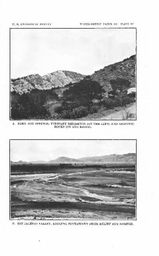
U. 8. GEOLOGICAL SURVEY WATER-SUPPLY PAPER 429 PLATE IV
A. EDEN HOT SPRINGS; TERTIARY SEDIMENTS (ON THE LEFT) AND GRANITIC ROCKS (ON THE RIGHT).
B. SAN JACINTO VALLEY, LOOKING SOUTHWARD FROM RELIEF HOT SPRINGS.

SAN JACINTO AREA. 25
Soboba Hot Springs, or Ritchey Hot Springs, about 5 miles east of the San Jacinto springs, are also situated near the base of the mountains. Six springs furnish water that ranges in temperature from 70° to 111° F., and is used for domestic supply and to irrigate a small orchard and garden. The Soboba springs issue in a steep> narrow ravine whose precipitous walls consist largely of crushed gneiss. Recent landslide patches within the ravine also indicate that the rocks of this area are broken and disturbed and furnish local evidence that the high temperature of the spring waters is due to crushing and slipping of the rocks. Water from the spring highest on the hillside (No. 123, PL III) is shown by analysis tabu lated opposite page 30 to be moderate in mineral content, but it is interesting because of its comparatively high content of silica one- quarter of the total solids and for nearly as great a proportion of normal carbonate. This high content of silica and carbonate, together with the large proportion of alkalies and very little calcium and magnesium, shows plainly that the water is derived from granitic rocks. The following analysis of water from another spring of the group shows it to be somewhat more concentrated. It is high in silica and bicarbonate, but carbonate is reported absent. Sodium is proportionately high, but calcium and magnesium are present in almost insignificant amounts.
Analysis of water from Soboba Hot Springs.
[Arthur R. Maas, analyst; about 1910.]Parts per
million.Silica (SiOa)................................................... 95
Iron and aluminum oxides (Fe2O3+Al2O3)...................... 1.3Calcium (Ca)................................................... 2.0Magnesium (Mg).............................................. .3Sodium (Na)................................................... 128Potassium (K)................................................ 2.5Lithium (Li).................................................. Tr.Carbonate radicle (CO 3)........................................ .0Bicarbonate radicle (HC0 3)..................................... 214Sulphate radicle (SO4).......................................... 59Chloride radicle (01)........................................... 38Phosphate radicle (PO 4)........................................ Tr.Nitrite radicle (NO2).......................................... Tr.Total solids by summation (bicarbonate calculated as carbonate). 431
On Indian Creek, 5 miles southwest of the Soboba springs, two or more springs of tepid, faintly sulphureted water issue from the granite, practically on the upper border of the sedimentary deposits of gravel and clay that cover the lower slopes. In 1915 the springs were unimproved but they were used occasionally by the local inhabitants for bathing.
26 GBOUND WATER IN SAF JACIFTO AiSTD TEMECULA BASINS, CAL.
*» Si -3 (\J Cj (\j(^ ty W C^.
I I> .8
J 4
Si <*> !*) ^^ * «tl O
SAN JACIFTO AREA. 27
ARTESIAN AREA.
For the last 40 years or more flowing artesian wells have furnished water in the vicinity of San Jacinto. Many wells 6 or 8 inches in diameter have supplied water for irrigation of small tracts and numerous 2-inch wells have supplied domestic needs. It has been estimated that fully 1,500 wells, all flowing, have been sunk in the artesian area. The extent of this artesian area, as approximately outlined by the numerous wells, is shown in Plate III (in pocket). The northwestern limit of the flowing-well area was formerly con sidered to be about at Casa Loma, but since 1911 a number of wells, still farther northwest, in the area known as Brownlands, have obtained flowing water. On the north the area hi which wells flow extends across the river channel nearly to the base of the mountain slopes. On the south it is fairly definitely limited by a low bench that separates the lowlands of the valley from the slightly higher mesa lands still farther south. This bench is practically continuous from the head of the valley east of Florida to Casa Loma and probably marks the southern bank of the river at a former time.
The depth to layers of sand and gravel that carry artesian water is in general between 100 and 200 feet throughout the valley. The depth at which flowing water may be obtained varies considerably from place to place, however, and in some localities it varies greatly within short distances. This variation is exemplified at the ranch of Mr. H. C. Warren, about 2 miles northwest of San Jacinto. One well here obtained flowing water at a depth of 120 feet, but another well only 18 feet away was sunk to a depth of 254 feet before ob taining a good flow. Two other wells near by found flowing water at depths of 150 and 320 feet, respectively.
The logs of five flowing wells (Nos. 90, 93, 96, 98, and 121 on PI. Ill, in pocket), sunk a number of years ago in the lowland northwest of San Jacinto, are given in figure 3. These logs show the variation in the occurrence and thickness of the water-bearing layers and indi cate that the flowing water is obtained from the sand and gravel of the valley alluvium. It is possible, however, that in a few places the sedimentary beds that form Park Hill and the hill at Casa Loma are penetrated by some wells, as the drillings from these materials probably would not be distinguishable from those from more recent gravels.
The greatly increased demand on the ground-water supply, due to the extensive development of irrigation and the establishment of pumping plants, has noticeably reduced the artesian pressure within recent years, so t'hat flowing wells yield less than they did a number of years ago. In the upper, southeastern end of the area a number of wells have entirely ceased to flow, but throughout this part of the area the wells are very responsive to the seasonal changes in the
28 GROUND WATER IN SAN JACINTO AND TEMECULA BASINS, CAL.
draft, and some of them which cease to flow in the early summer when the pumping for irrigation is begun resume flowing shortly after the general reduction of irrigation in the fall. A smaller but noticeable change is also produced by the cumulative effect of the varying rainfall of different winters. The following records of fluc tuation have been kept at two wells near the upper limit of the artesian area.
Water levels in observation u'ells in the San Jacinto area.
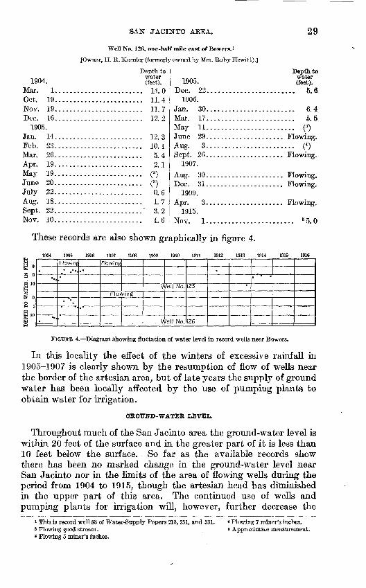
Well No. 125, at Bowers. 1
[Owner, C. A. Holmes (formerly owned by J. Carmichael).]
1904 Mar. Oct. Nov. Dec.
1905 Jan. Feb. Mar. Apr. May June July Aug. Sept. Nov. Dec.
1906. Jan. Mar. May Aug. Sept. Dec.
1907. Feb. May
Depth to water (feet).
.. 3.0
.. 7.6
.. 7.8
.. 8.0
................... 8.1
................... 6. 7
................... 4. 2
................... 2. 319..................... Flowing.21..................... Flowing.22..................... Flowing.18........................ 3.722........................ 2.510........................ 2.722........................ 3.1
30........................ 2.717........................ 2.711 .................... Flowing.
3 .................... Flowing.26 .................... Flowing.20 .................... Flowing.
13..................... Flowing.18..................... Flowing.
Depth to w-ater (feet).1907.
Aug. 30........................ ( 2)Dec. 31........................ ( 2 )
1909. Apr. 3..................... Flowing.July 11........................ (2 )Oct. 14..................... Flowing.
1910. Feb. 3..................... Flowing.Aug. 11........................ 3 1.0
1911. Jan. 5........................ 3 1.0
1912. May 28........................ 3 3.0
1913. Oct. 18........................ 10.7
1914. Feb. 5........................ 6.2Apr. 17...............;........ 4.7June 25........................ 5.7Nov. 21........................ 5.7
1915. May 21............. Flowing slightly.Oct. 31........................ 4.8
1916. May 5..................... Flowing.Nov. 15.............. Flowing slightly.
1 This number corresponds to the number of well on PI. Ill aad to well No. 84 of Water-Supply Papers 231, 251, and 331.
2 Flowing 1 miner's inch.3 Approximate measurement.
SAN JACINTO AREA.
Well No. 126, one-half mile east of Bowers.*
[Owner, H. R. Kumler (formerly owned by Mrs. Ruby Hewitt).]
29
1904. Mar. 1...........Oct. 19...........Nov. 19...........Dec. 16............
1905.Jan. 14 ............Feb. 23............Mar. 26............Apr. 19............May 19............June 20 ............July 22............Aug. 18............Sept. 22............Nov. 10............
Depth to water (feet).
14 0
U 4
............ 11. 7
............ 12. 2
19 Q
............ 10. 1
............ 5. 49 l
............ o
............ o
............ 0. 6
............ 1. 7Q 0
............ 4. 6
1905. Dec. 22...........
1906.Jan. 30...........Mar. 17...........May 11...........June 29...........Aug. 3...........Sept. 26...........
1907.
Aug. 30...........Tipf ^1
1QOQ
Apr. 3...........nqi K
Nov. 1...........
Depth towater (feet).
............. 5.6
............. 6.4
............. 5. 5
............. (3)
............. («)
............. 5 5.0
These records are also shown graphically in figure 4.
1904 1905 1906 1907 1908 1909 1910 1911 1912 1913 1914 1915' 1916
DEPTH TO WATER, IN FEEI.
-..
.,
Flowing
.* **
'.*
.«
"
Flowing
FlovvmgV
V
*/el! No.
/ell No.
IZ5
126
*
* *
FIGUBE 4. Diagram showing fluetation of water level in record wells near Bowers.
In this locality the effect of the winters of excessive rainfall in 1905-1907 is clearly shown by the resumption of flow of wells near the border of the artesian area, but of late years the supply of ground water has been locally affected by the use of pumping plants to obtain water for irrigation.
GROUND-WATER LEVEL.
Throughout much of the San Jacinto area the ground-water level is within 20 feet of the surface and in the greater part of it is less than 10 feet below the surface. So far as the available records show there has been no marked change in the ground-water level near San Jacinto nor in the limits of the area of flowing wells during the period from 1904 to 1915, though the artesian head has diminished in the upper part of this area. The continued use of wells and pumping plants for irrigation will, however, further decrease the
1 This is record well 83 of Water-Supply Papers 213,251, and 331.2 Flowing good stream. » Flowing 5 miner's inches.
< Flowing 7 miner's inches. 6 Approximate measurement.

30 GROUND WATER, IN SAN JACINTO AND TEMECULA BASINS, CAL.
artesian head, and the area in which wells will flow may shrink considerably unless a series of wet years provides sufficient ground water to keep pace with the increased draft. In the lower kinds the ground-water level is at present so close to the surface, that it is improbable that the pumping lift will there become seriously great for a number of years. In the upper end of the valley, near Florida, the depth to water increases with the upward slope of the surface, but the ground-water table also slopes upward so that, although in the vicinity of Florida the surface of the land rises 100 feet in a dis tance of 1^ miles, the depth to water increases only about 60 feet in that distance.
IRRIGATION.
Until about 1908 irrigation in the San Jacinto artesian area was restricted largely to the watering of such tracts of garden and alfalfa as could be served by the flowing wells. Fruit growing was also carried on in a small way, and dairying to the extent permitted by the small alfalfa fields. In recent years irrigation has become more extensively practiced, however. Small pumps have been installed at many of the old wells and at new wells of larger diameter, and many of these plants are conveniently operated by electric power. Several distillate pumping plants have also been installed in the artesian area and draw large quantities of water from the ground supply. The approximate distribution of pumping plants and the lands under irrigation in 1915 are shown in Plate V (in pocket).
In the pumping wells it is customary to perforate the casing at all water-bearing horizons, so that the strata in which the water is under notable artesian pressure are not the only ones drawn upon. The pumping lift is small and is partly overcome by the artesian pressure.
Beyond the limits of the area of flowing wells a large acreage south and southwest of San Jacinto is supplied by the canal system of the Citizens Water Co. Late in the season a part of the water of this system is pumped, the company having four groups of wells in 1915. A considerable acreage to the southeast, above the company's canal, is irrigated by individual plants. In the summer of 1915 a well was sunk a mile west of Florida, where the ground-water level is about 50 feet below the surface, a pumping plant was installed, and a large area was planted in orchards of deciduous trees. A mile east of Florida, on the Copeland ranch, ground water is used to irrigate citrus trees. Here water was struck at a depth of 85 feet, the well (No. 134 of PL III, in pocket) being continued to 458 feet. The relative thick ness of the water-bearing strata at this place is shown graphically by the log of well 134 in figure 3 (p. 26). Ground water is also used for irrigation beyond the limits of the main valley lands, up the narrow valleys of the South Fork of San Jacinto River and of Bautista Creek. In 1915 a distillate plant near the channel of the South
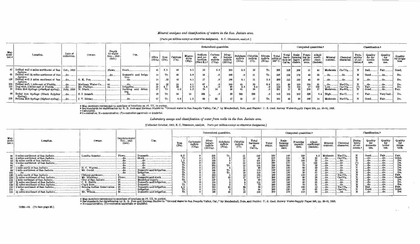
Mineral analyses and classification of waters in the San Jacinto area.
[Parts per million except as otherwise designated. S. C. Dinsmore, analyst.]
Map num- ber.o
87
91
128
134 135
16
89
123
Location.
Drilled well 4 miles northwest of San Jacinto.
Drilled well 2J miles northwest of San Jacinto.
Drilled well 2 miles southeast of San Jacinto.
Drilled well, 1 mile east of Florida. .... Dug well, 3 miles east of Florida. ..... Eden Hot Springs (principal spring). .
Relief Hot Springs (Black Sulphur
Date of collection.
Oct., 1915
...do......
...do......
...do......
...do...... July, 1916
...do......
...do......
Owner.
G. K. Fox............
Mr. Phillips. ..........N. Black..............
J.T.Richey. .........
Depth to water
Nov., 1915 (feet).
Flows. ....
...do......
23.........
8012.........
Use.
Stock.................
Domestic and irriga tion.
.....do................
.....do................
Bathing and drink ing.
.....do................
Determined quantities.
Silica (SiOj).
41
24
24
20 33 37
29
67
Iron (Fe).
5.5
Tr.
.55
.25 2.7Tr.
Tr.
Tr.
Calcium(Ca).
48
46
40
33 22 5-0
54
6.0
Magne sium (Mg).
8.1
5.9
6.1
4.1 5.0 1.2
14
1.2
Sodium and po tassium
(Na+K).e
19
16
17
67 6.4
78
193
65
Carbon ate
radicle (CO,).
0.0
.0
.0
.0
.0 14
x -°
55
Bicar bonate radicle
(HCO,).
219
192
166
148 90 56
58
17
Sulphate radicle (S0«).
0.0
.0
9.1
43 2.8
61
233
31
Chloride radicle
(Cl).
10
11
11
52 9.0
38
229
17
Nitrate radicle (NO,).
Tr.
Tr.
2.0
6.0 .0 .0
.0
Tr.
Total solids at 180° C.
256
216
200
311 124 281
815
263
Computed quantities.*
Total hard
ness as CaCoi.
153
153
125
99 76 17
192
20
Scale- forming ingre
dients.
200
170
150
120 100 50
210
90
Foam ing in- gredi- ents.
51
43
46
180 17
210
520
180
Alkali coeffi cient
(inches).
42
53
69
21 220
17
8.4
14
Mineral content.
Moderate .
...do......
...do......
...do......
Moderate..
High......
Moderate .
Classification^
Chemical character.
Ca-CO,....
...do......
...do......
Na-CO,.... Ca-CO,....Na-S04 ....
Na-Cl.....
Na-CO»....
Prob ability of cor-
rosion.d
N
N
N
N
ffC
N
Quality for do mestic
use.
Bad.......
Good......
...do......
...do......Fair....... Good......
Good......
Quality for
boiler use.
Fair.......
...do......
...do......
...do......
...do......
...do......
Very bad..
Fair.......
Quality for irriga
tion
Good.
Do.
Do.
Do. Do.
Fair.
Do.
Do.
o Map numbers correspond to numbers of locations on Pi. Ill, in pocket.6 See standards for classification by R. B. Dole and Herman Stabler in "Ground water in San Joaquin Valley, Cal.," by Mendenhall, Dole, and Stabler: U. S. Geol. Survey Water-Supply Paper 398, pp. 50-81,1916.c Calculated.d c=corrosive; N=noneorrosive; (?)=corrosionuncertain or doubtful.
Laboratory assays and classification of water from wells in the San Jacinto area.
[Collected October, 1915; S. C. Dinsmore, analyst. Parts per million except as otherwise designated.]
Map num- ber.o
86 88 92 94 95 97 99
100 120 122 124 127 129 130 131 133
Location.
.....do...............................................
1 mile northwest of San Jacinto. ..................... .....do...............................................
1J miles southeast of San Jacinto. ....................
.....do...............................................
Owner.
Mr. Gould. .................
C.E. Smith.. ...............
Soboba Indian Reservation . .....do......................
Depthto water Nov., 1915
(feet).
Flows. .............do.............do.............do.............do.............do.............do........ .....do........4..............
10.............25............. 30.............28.............18.............50.............
Use.
Domestic. ..................
.....do......................
.....do......................
.....do......................
.....do......................Domestic and irrigation .....
Domestic and stock .........
D omestic and irrigation .....
Domestic and irrigation .....
Domestic and irrigation .....
Determined quantities.
Iron (Fe).
0.5 Tr.
1.5 Tr. Tr. Tr. Tr. Tr. Tr. Tr. Tr. .75 Tr.
4.5 Tr. Tr.
Carbonate radicle (CO,).
0 0 0 0 0 0 0 0 0 0 0 0 0 0 0 0
Bicar bonate radicle
(HCO,).
325 173 185 166 203 181 166 151 259 217 127 151 134 215 119 190
Sulphate radicle(S04).
Tr. 5 5 5
Tr. 5
Tr. Tr.
5 10 5 5 5
10 5
38
Chloride radicle
(Cl).
11 12 11 10 13 11 10 10 12 17 9 9 7
23 11 15
Total hardness
as CaCOg.
110 95
101 138 135 99
115 118 123 147 88
111 72 88 86
136
Computed quantities. 6
Total solids.
330 210 210 200 230 210 190 180 280 260 160 180 160 270 160 270
Scale- forming ingredi
ents.
140 120 130 170 160 130 140 150 150 180 120 140 100 120 120 170
Foaming ingredi
ents.
230 90
100 20 70 90 50 30
150 90 50 40 70
180 40
110
Alkali coefficient (inches).
8.0 23 22
190 32 22 45 97 13 28 55 65 31 12 65 35
Mineral content.
Moderate . ...do...... ...do...... ...do.........do.........do...... ...do...... ...do.........do.........do...... ...do...... ...do...... ...do.........do.........do...... ...do......
Classification.!)
Chemical character.
Na-COs... Ca-CO 3.... ...do...... ...do.........do.........do...... ...do...... ...do......Na-C03 . . . Ca-CO,.. . . ...do...... ...do...... ...do......Na-COj.... Ca-CO 8.. . .
...do......
Proba bility of cor rosion. «
N N N
9N N N N N N N N N N N
Quality for
domestic use.
Good...... ...do...... ...do...... ...do...... ...do...... ...do.........do...... ...do...... ...do...... ...do...... ...do...... ...do...... ...do...... Bad....... Good.. ... ...do......
Quality for
boiler use.
Fair....... ...do...... ...do...... ...do...... ...do...... ...do.........do...... ...do...... ...do...... ...do...... ...do...... ...do...... ...do...... ...do...... ...do...... ...do......
Quality for
irriga tion.
Fair. Good.
Do. Do. Do. Do. Do. Do.
Fair. Good.
Do. Do. Do.
Fair. Good.
Do.
71065 19. (To face page 30.)
o Map numbers correspond to numbers of locations on Pi. Ill, in pocket.«> See standards for classification by R. B. Dole and Herman Stabler in "Ground water in San Joaquin Valley, Cal.," by Mendenhall, Dole, and Stabler: U. S. Geol. Surrey Water-Supply Paper 398, pp. 50-81,1916.* N=noncorrosive; (?)=corrosion uncertain or doubtful.


U. S. GEOLOGICAL SURVEY WATER-SUPPLY PAPER 429 PLATE VII
Northwest.
SAN JACINTO VALLEY FROM PARK HILL.East.

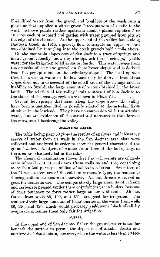
SAN JACIETO AEEA. 31
Fork lifted water from the gravel and boulders of the wash into a pipe line that supplied a citrus grove three-quarters of a mile to the west. At two points farther upstream smaller plants supplied 5 or 10 acres each of orchard and garden with water pumped from pits at the edge of the channel. At the upper end of the valley lands along Bautista Creek, in 1915, a gravity flow to irrigate an apple orchard was obtained by tunneling into the creek gravels half a mile above.
On the mountain slopes east of San Jacinto a tract of springs and moist ground, locally known by the Spanish term a ci^naga," yields water for the irrigation of adjacent orchards. This water issues from the deposits of clay and gravel on these lower slopes and is derived from the precipitation on the tributary slopes. The local opinion that the artesian water in the lowlands may be derived from these slopes does not take account of the small area of the cienaga and its inability to furnish the large amount of water obtained in the lower lands. The relation of the valley lands southeast of San Jacinto to the slopes of the cienaga region are shown in Plate VII.
Several hot springs that issue along the slope above the valley have been sometimes cited as possibly related to the artesian flows obtained in the lowland. They have no connection with the artesian water, but are evidences of the structural movements that formed the escarpment bordering the valley.
QUALITY OF WATER.
The table facing page 30 gives the results of analyses and laboratory assays of water from 21 wells in the San Jacinto area that were collected and analyzed in order to show the general character of the ground water. Analyses of waters from three of the hot springs in the area are also included in the table.
The chemical examination shows that the well waters are of mod erate mineral content, only two (from wells 86 and 134) containing more than 300 parts per million of solids in solution. Seventeen of the 21 well waters are of the calcium-carbonate type, the remaining 4 being sodium-carbonate in character. All but three are classed as good for domestic use. The comparatively large amounts of calcium and carbonate present render them only fair for use in boilers, because of their tendency to form rather large amounts of scale. All but three from wells 86, 120, and 130 are good for irrigation. The comparatively large amounts of bicarbonates in the water from wells 86, 120, and 130, which would probably yield some black alkali by evaporation, render them only fair for irrigation.
ALKALI.
In the upper end of San Jacinto Valley the ground water is too far beneath the surface to permit the deposition of alkali. North and northwest of San Jacinto, however, where the water is less than 10 feet

32 GROUND WATER, IN SAN JACINTO AND TEMECULA BASINS, CAL.
beneath much of the lowland, alkaline salts have collected to some extent in a few places, and the tendency for the soil of the lower areas to become alkaline will increase with the increase.of irrigation and consequent still further rise of the ground-water level. The good quality of the deeper ground water throughout most of the area, how ever, renders it available for partly remedying the trouble by careful irrigation combined with proper drainage and the application of gypsum (land plaster) to the worst spots. The lowland sov^ and southeast of Casa Loma is naturally alkaline, owing to the long- continued evaporation of ground water from it and the consequent collection of the mineral salts at the surface. These lands = have, therefore, been given over to pasturage, and it seems doubtful whether they can be profitably brought under cultivation, though they might be made to produce sugar beets or other alkali-resisting forage crops.
HEMET AREA.
LOCATION AND CHARACTER.
The Hemet area embraces the large open valley that lies bef een Park Hill and the granitic slopes to the south and also lands iiat slope gently westward and southwestward to the bases of ou ing hills near Lakeview Mountains. During floods the drainage passes westward through Winchester Valley, but the slope is so gentle and the valley fill is so porous that the normal run-off is slight. South of Hemet the open, nearly level land extends to Diamond Vr 3j, which forms a reentrant in the hills that border the drainage I ?m. This open valley is in most places covered with alluvium washed c \vn from the adjacent slopes, but in its southeastern end there are heavy bench deposits of older alluvium (see PI. Ill, in pocket), which are perhaps contemporaneous with some of the deposits along the r-per borders of San Jacinto Valley.
GROUND-WATER LEVEL.
Beneath the higher lands east and southeast of Hemet the ^ uund- water level is more than 60 feet below the surface, and in the two or three wells that were examined in 1915 pumping lifts of fully 100 feet were reported. The depth to water decreases westward, hx 7- ever, and beneath the mesa lands water is found at depths of 20 to 1 feet. In the lowland west of Egan and toward Wildomar, the watej is within 10 feet of the surface. To the south, in Diamond Valley, water is found at depths of 30 to 60 feet, the depth rapidly increasing as the land slopes upward to the deposits of older alluvium at the southern end.
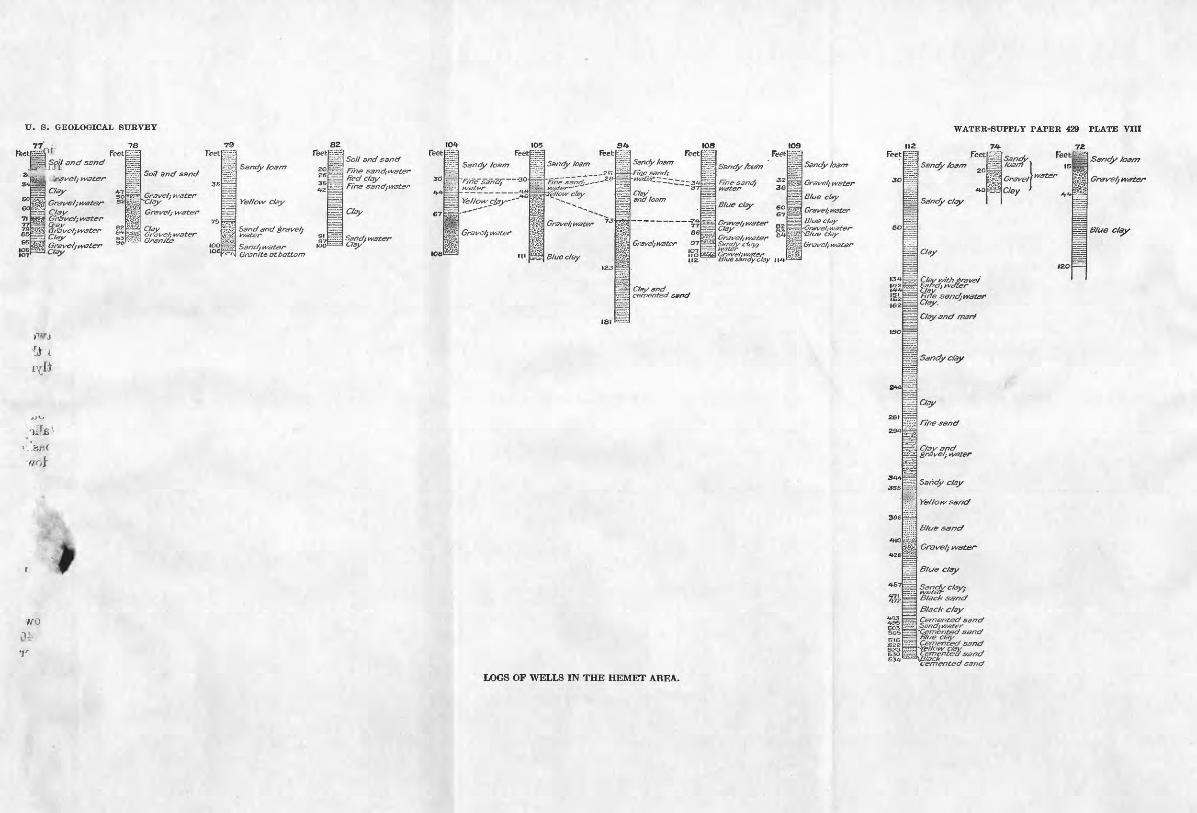
U. S. GEOLOGICAL SUKVEY
Feet
WATEK-SUPPLY PAPEK 429 PLATE VIII
s(Hi*5im
>TS»
"d
*jo
'teTj
*
3
^0
fc,
H Feet
Clay tn _ , so Gr&ve/j w3tGt~ 5ECV.sy^Gr&ise/;w3ter
ara\sel;tvater SJC/^- 93
Gf&V& ft W3£&FClay
M
I
B\
C
P
&
73
Hirr.v;
E^ii
fe^
ilfcgg
H
Feet
So// 9/74/SS/7C/
Gravel: water -Clay
Gravelj water75
s^u^^100106
79
H
fflnily^f;;
8;-;l"ii^-7.
Teet
2e
W/OM, ^
S r nd^Ve'] «
^^/7^/' tA/fif^f* \QQ
Granite at bottom
82
s^^=^7
m==B" "
104 105 54 108 109 112 74-Feetphi Feet ^ Feet ^ Feet i^ Feet i^r R?et
o/ an san t §afldy /ogm isrg: Sandy loam '^± Sandy ham ^3 $ancfy farr? §P Sandy ham Fine sandtw&ter f-£-2 ^-zi^ _25- ^^ -//c^ sdnd$ ^"^^ ^"^ncci c jy J.:.. *.;.: Fine sanc/i ^ ;:j :~:=; Fine sanef-^.*- =~^. **f£f cV ^ ~~3^ iTrV-i Fine s&ndr ^z jjgdg Grsvel'wstsr ^^rine ssncfjW&ter |>V'*"-" : - w&t&r t^t, *&.-. wgter-'~'~f -^^ . """"37 W&£GP 36 ^== '
^^*"^EZ - ^. ^^ "3&/OW cfey z^E^r Clgy ==± ^=^ o/ - -/ ., ^^£ yeJ/ow ctey """ ?^c^ "^"-^. E^£ snd lodfn ==~ o/ / ^^
^k 7^p-*"'^"*" 111 ^"^-^ ^ ' ^ IvB Grave/;W3terl|l| 5^| ^ . ^,3 ^t^ -._ . _y^(. f^ Grw& f water ^^ ^/t/tf1 £/?K
Sand: w&t.&r po°o^ ' «^^ ripji* §>r"o» Gr&ise/i w&t&t* '&%*%.Cidy fe-v^p >%o"jg io^o GrsveljWBt&f* &~f =^ Sswcfy dctyj &j5*S Gf&vG/t w3£&/*
l^^tsiaj I.. £0^ . . v"k<6 110 !?''::i''c' Gr&v&liW&t&r %%%% ^=~-f~- &'UQ cfQy |'o%« n2 B/uGsanc/yc/dy iif ~ "^^
IE3^|.
!== C/ay and wt ^si cemented sand Jg' ^g 162
181 ^
ISO
246
201
fftm^.i^i
ss:=SEd
s?HE
=ESS
HHs
S
ffi=^=^JMi
P
8
386
r«27'
E03 505
S22523B30
IBII1|^^Hn1iS
Sandy fosm ±'±-- loam ]20 ^^ 1
^oK§c/sy '
Sandy clay
Clay
Clay with£rai/ff/ Sanc/i water Clay ' Fine sandiwater Clsy.
Clgy and marl
Sandy clay
Clay
Fine sand
Clay andgrave/; water
Sandy clay
Yte/lotv sancf
Blue sane/
Gra\/elj water
Blue clay
Bfact< ffancf
Black c/ayCemented sand Send; water "Cemented sand Blue c/ayCemented sandCemented sand
\Black , _,
72Feet r "^
fe: Sandy loamIB ^
£g& Grave Jj water
^1
~^s:IO Blue clay
=
J2O ==
LOGS OF WELLS IN THE HEMET AREA.
rv/
i > tft :/«
HEMET AREA. - 33
The logs of several wells in the Hemet area (PI. VIII) show that the water-bearing strata, as in the lower lands near San Jacinto, are by no means uniform in thickness or in position.
In the extreme western part of Hemet Valley, as would be expected bedrock is encountered comparatively near the surface (in wells 78 and 79), but in the main part of the valley wells more than 500 feet deep do not reach the bedrock. The variation in the thickness of the water-bearing gravels is shown in the logs of wells 104, 105, 106, 108, and 109, which are near the northern part of the mesa land. To the south, in the vicinity of Egan, the water-bearing strata appear to be more uniform. The following records have been kept of the water level in three wells? situated respectively one-half mile west of Egan, 1 mile west of Hemet, and 1 mile northeast of this town.
Water levels in observation wells in the Hemet area.
Well No. 73, one-half mile west of Egan.1
[Owner, Mrs. Maud F. Walker.]
1905.Apr. 18........May 19 ........June 20.........July 23........
Sept. 23........Nov. 10........Dec. 22........
1906. Jan. 30 ........Mar. 16 ........May 12 ........June 28........
Sept. 27 ........Dec 21
1907. Feb. 14........Aug. 30........Dec. 31........
1908.
June 25 ........
Depth to water (feet).
................ 10.5............... 10. 8............... 10. 5............... 10.5
............... 11.1
............... 10. 9
............... 11.2
............... 10. 7................ 10. 6
10 3
9 a
in 3
q o
............... 9.7................ 9.7
9 0
................ 9.5
1909. Apr. 2...........
1910. Feb. 3...........Aug. 10 ...........
1912. July 20...........
1913. Oct. 18 ...........
1914. Feb. 5...........Apr. 17 ............June 25 ...........Aug. 14 ...........Nov. 21...........
1915. Oct. 31...........
1916.Mnv ft
Aug. 1 ...........Nov. 16...........
Depth to water
fieet). ............. 9.6
............. 9.3
............. 10.2
9 Q
............. 12.9
............. 10.5
............. 10.2
............. 13. 2
............. 12.7
............. 11.0
............. 11.4
............. 10.1
............. 12. 7
............. 10.1
71065°1 Tliis is record well 81 of Water-Supply Papers 213, 251, and 331. -19 WSP 429 3

34 GROUND WATER IN SAN JACINTO AND TEMECULA BASINS, GAL.
Well No. 114, 1 ntrile west of HemeU
[Owner, J. E. Garrigan.]
1904.Mar. 14 ............Dec. 15............
1905. Jan. 14 ............Feb. 23............Mar. 25 ............Apr. 18 ............May 18 ............June 20 ............July 23............Aug. 19............Sept. 23 ............Nov. 10............
1906.Jan. 30 ............Mar. 17............Mav 19
June 29............
Sept. 27 ............T)pr> 90
1907. Feb. 13............May 18 ............ Aug. 31............Dec. 31............
-| OAQ
Ar>r 93
June 25 ............Oct. 15 ............Dec. 28............
Depth to water (feet).
............ 33.0
............ 33. 2
............ 33. 4
............ 33. 2
............ 33. 1
............ 33. 1
............ 33. 0
............ OO. £
............ 33. 1
............ 34. 0
............ 33. 5
............ 33. 0
............ 32. 7
............ 32. 4QO fi
qo K
qo 7
OO &
OO t^
00 fl
qo K
............ 32. 5
............ 31.8
31 Q
............ 31.7
............ 31.1
............ 31.7
1909. Apr. 2 ...........July 11...........Oct. 14 ...........
1910.Feb. 3 ...........Aug. 11...........
1911.Jan. 5 ...........
1010
May 28 ............July 30............
1913. Oct. 18 ............
1914.Feb. 2 ............Apr. 17 ............June 25 ............Aug. 14 ............Nov. 21............
1915. May 21............Oct. 31 ............
1916.May 6 ............Aug. 7 ............Nov. 15............
Depth, to water (teet).
............ 31.6
............ 31.5
............ 31. 3
............ 31.2
............ 31.1
............ 30.8
39 9on c
............ 31.6
............ 30. 6
............ 30. 7
............ 30. 8
............ 31.1
............ 30. 9
............ 31.2
............ 31.0
............ 29. 9
............ 30. 3
............ 29. 8
This is record well 82 of Water-Supply Papers 213, 251, and 331.
HEMET AREA.
Well No. 118, 1 mile northeast of Hemet.
[Owner, J. A. Barger (formerly owned by W. D. Baisley).]
1905. Nov. 10........
1906. Jan. 30 ...........Mar. 17...... .Sept. 26......... .Dec. 20............
1907.May 18......... ..Dec. 31......... ..
1908.Apr. 22 ............June 24......... ..Oct. 15 ............Dec. 29............
1909.Apr. 3 ............July A.I.. ..........Oct. 14 ............
1910.Feb. 3 ............Aug. 11............
Depth to water (feet).
............ 57. 3
............ 58. 0
............ 56. 9
............ 58. 1tV7 Q
............ 57. 2K7 O
............. 57.2
............. 57.2
............. 57.4K.1 O
............. 57.1
............. 58.0K7 A
............ 56. 3
............ 55. 9
1911.
1912.May 28 ........July 29........Oct. 18 ........
1913. Oct. 18 ........
1914.Feb. 5 ........Apr. 17........
Nov. 21........
1915. May 23 ........Oct. 31 ........
1916.Aug. 1 ........Nov. 15........
Depth to water (feet).
KK 0
K/> f\
t*ft f\
jy. 7
K7 Q
................ 55. 5
................ 55.9Cf> C
K7 f\
................ 56.5
............... 55. 6Cf> B
............... 56.4
............... 56. 0
The variation in the water level in these three wells is shown graphically in figure 5, and indicates that during the period of record there have been only minor fluctuations in the ground-water level in the vicinity of the wells measured.
1913
IN FEET W 0
E- 30
^35 0£ <
£ 55Q 60
. ..........
...... . . . . . .
v
. . .
.
/ell No.
73
'
V/en rju.Mt
Well No. 118
* *
.
1
..
. .
* *
*
* *
*
FIGURE 5. Diagram showing fluctuation of water level in record wells in the Hemet area.
The depth to water throughout the Hemet area was determined in March, 1904, and again in November, 1915, by measuring many wells in the area. The depths at the respective periods are indi cated in Plate III (in pocket) by lines that show depth to water in 1904 and 1915. These lines indicate that in the mesa lands the water level has risen 5 to 10 feet. This rise may have been caused chiefly by the extensive irrigation in the region by surface water, but
36 GROUND WATER IN SAN JACINTO AND TEMECULA BASINS, GAL.
as rainfall was deficient in 1904 and above the average in 1914 and 1915, the rise may be due chiefly to increased rainfall in the later years.
IRRIGATION.
The extensive orchards south and east of Hemet (see PL IX, B} are supplied almost entirely with water from Hemet reservoir. On two or three tracts that have no water right under the system, pump ing plants have been installed, but the ground water here is rather deep and the pumping lift is correspondingly heavy. Within recent years fields of alfalfa and orchards of deciduous trees on a large area of the mesa lands lying beyond the limits of the canals of the San Jacinto and the Hemet companies have been brought under irrigation by 'means of individual pumping plants capable of deliver ing 50 to 100 miner's inches of water, the pumping lift being between 20 and 50 feet. The soil of these mesa lands is light and sandy, is easily tilled, and seems to have good underdrainage, for in 1915 no water-soaked or alkaline areas were seen. The cost of pumping also leads to more careful use of water on these lands than on lands supplied with water by gravity, and hence they are not so likely to become water-logged.
In the western extension of the mesa lands, near the base of Lake- view Mountains, a number of wells sunk in 1915 in the east half of sec. 11, T. 5 S., R. 2 W., obtained water at depths of 20 to 50 feet. These higher lands were to be planted to orchards of deciduous trees.
North and south of Egan large areas were in 1912-1915 set out to alfalfa, which was irrigated with water lifted either by electric power or by distillate engines. The ground-water level is near the surface, and wells 200 feet or more in depth have obtained large supplies. As the casings are usually perforated at all water-bearing horizons, so as obtain the maximum yield from each well, the wells tap not only the shallower waters, which in this locality are some what alkaline, but the deeper waters which are of better quality.
Practically all of Diamond Valley has been given over to the dry farming of grain. In 1915, however, a number of 12-inch wells were drilled at intervals across its upper end, and it was the inten tion to subdivide the large holding that embraces most of the valley and set out the land to orchards. The drainage area tributary to the upper part of the valley includes about 30 square miles and the greater part of this area consists of steep slopes 2,000 to 3,500 feet in elevation. The run-off from these slopes to the valley lands is therefore presumably large, but the amount that is absorbed by the lowlands and is available for recovery by wells had not, in 1915, been tested. Only two areas, each consisting of about 10 acres of alfalfa, were irrigated in 1915. Each was supplied with water from a dug well by a small pumping plant.
Mineral analyses and classification of water from wells in the Hemet area.
[Parts per million except as otherwise designated. S. C. Dinsmore, analyst.]
Map num ber .a
69
70 75
84
Location.
Drilled well, 5 miles southwest of Hemet.
Dug well, 5 miles south of Hemet ...... Drilled well, 2£ miles southwest of
Hemet. Drilled well, 4 miles northwest of
Hemet.
Date of collection.
Aug., 1916
...do....... Nov., 1915
Oct., 1915
Owner.
O.C.Searle.. .........
T. E. Deming.........
Walberg-Dozier Land Co.
Depth to water
Nov., 1915 (feet).
40
457
12
Use.
Domestic and irriga tion.
Determined quantities.
Silica (fflOi).
50
44 30
23
Iron (Fe).
0.20
Tr. .20
.50
Calcium (Ca).
62
57 79
59
Magne sium (Mg).
17
6.0 14
9.8
Sodium and po tassium
(Na+K).c
76
76 146
25
Carbon ate
radicle (COi).
0.0
.0
.0
.0
Bicar bonate radicle
(HC08).
224
268 136
236
Sulphate radicle(S04).
83
26 233
11
Chloride radicle
(Cl).
83
56 152
26
Nitrate radicle (N08).
2.0
7.0 3.0
.0
Total solids at 180° C.
493
403 753
295
Computed quantities.!*
Total hard
ness as CaCos.
225
167 255
188
Scale- forming ingre dients.
260
220 290
210
Foam ing in gredi ents.
200
200 390
68
Alkali coeffi cient
(inches).
23
14 12
56
Classifications
Mineral content.
Moderate. .
...do.......High......
Moderate..
Chemical character.
Na-COs. . .
...do.......Na-S04....
Ca-CO,....
Prob ability of cor-
rosion.d
(?)
N (?)
N
Quality for do mestic use.
Fair.......
Fair.......
Good......
Quality for
boiler use.
...do.......Bad.......
Poor......
Quality for irriga
tion.
Good.
Fair. Do.
Good.
» Map numbers correspond to numbers of locations on PI. Ill, in pocket.& See standards for classification by R. B. Dole and Herman Stabler in " Ground water in San Joaquin Valley, Cal.," by Mendenhall, Dole, and Stabler: U. S. Geol. Survey Water-Supply Paper 398, pp. 50-81,1916.c Calculated.
<* N=noneorrosive; (?)=corrosion uncertain or doubtful.
Laboratory assays and classification of water from wells and Hemet canal in the Hemet area.
[Parts per million except as otherwise designated. S. C. Dinsmore, analyst.]
Map num- ber.o
71 76 80 81 83 85
101 102 107 111 113 114 115 116 117 118 119 132
Location.
3 miles southwest of Hemet ......................
.....do........................ ..................
1£ miles south of Hemet. ......................... 1 mile southeast of Hemet ....................... 1 mile northeast of Hemet .......................
Date of collec tion.
Nov. 1915 ...do.......Oct. 1915 ...do..........do..........do..........do..........do..........do..........do..........do..........do..........do..........do....... ...do....... ...do....... ...do..........do.......
Owner.
I. M. Gibbel..............
J. H. Schein..... .......... G.P.Hill.. ............... J. A. Barger...... .........
Depth to water,
Nov., 1915
(feet).
21 18 12 12 S 6
12 13 30
Flows. 33 32 36 62
100 57 40
Stream.
Use.
.....do.....................
.....do.....................
.....do.....................
.....do.....................
.....do.....................
.....do.....................
.....do.....................
Stock.....................
.....do.....................
Domestic and irrigation . . .
.....do.....................
Determined quantities.
Iron (Fe).
Tr. Tr. Tr. Tr. Tr.
0.30 Tr. .05 Tr. Tr. .05 Tr. Tr. .75 Tr. .85 Tr. Tr.
Carbonate radicle (CO,).
0 0 0 0 0 0 0 0 0 0 0 0 0 0 0 0 0 0
Bicar bonate radicle (HCO,).
295 163 153 151 93
161 210 290 171 229 163 144 178 188 222 268 203 127
Sulphate radicle (S04).
132 5
130 104 168 287
5 10
132 10
121 164 222
95 229
33 5 5
Chloride radicle
(Cl).
178 46 81 55 49
197 12 61 43 17 54 95 56 61 60 16 16 12
Total hardness
as CaCOi.
79 85 73 96
125 168
91 232 140 178 140 140 204 172 205
60 110
88
Computed quantities.fc
Total solids.
770 250 480 400 440 910 240 390 540 270 440 550 600 430 660 340 240 170
Scale- forming ingred ients.
110 120 100 130 160 200 120 260 170 210 170 170 230 200 240 90
140 120
Foaming ingred ients.
760 160 400 300 260 730 140 140 270
60 260 380 350 230 410 300 110 50
Alkali coefficient (inches).
4.0 15 9.8
14 29 8.0
14 25 24 55 23 17 24 27 21 7.3
19 51
Classification .&
Mineral content.
High...... Moderate.. ...do..........do..........do.......High...... Moderate. . ...do.......High......Moderate.. ...do.......High.........do....... Moderate.. High......Moderate.. ...do..........do.......
Chemical character.
Na-Cl..... Na-CO,... Na-S04.... ...do..........do..........do....... Na-CO,. . Ca-COg...Na-S04...Ca-COg... Na-C03.. Na-S04... ...do....... ...do....... ...do.......Na-CO,...
Ca-CO,....
Proba bility of cor
rosion, c
N N N N
N
1N N
Quality for
domestic use.
Fair.......
...do.......
...do.......
...do.......Fair.......Good...... Fair.......
...do.......
...do.......
...do....... Fair..........do....... Good......
Good.........do....... ...do.......
Quality for
boiler use.
Very bad.. Fair.......Bad..........do....... ...do.......Very bad. - Fair....... Poor...... Bad.......Poor...... Bad....... ...do..........do.......Fair....... Very bad.. Bad.......Fair....... ...do.......
Quality for
irriga tion.
Poor. Fair.
Do. Do.
Good. Fair.
Do. Good.
Do. Do. Do.
Fair. Good.
Do. - Do. Fair. Good.
Do.
71065° 19. (To face page 36.)
o Map numbers correspond to numbers of locations on PI. Ill, in pocket.& See standards for classification by R. B. Dole and Herman Stabler in " Ground water in San Joaquin Valley, Cal.," by Mendenhall, Dole, and Stabler: U. S. Geol. Survey Water-Supply Paper 398, pp. 50-81,1916.« N=noncorrosive; (?)=corrosion uncertain or doubtful.

U. S. GEOLOGICAL SUEVEY WATEE-SUPPLY PAPER 429 PLATE
A. PERRIS AND ALESSANDRO VALLEYS, FROM POINT ABOUT 2 MILES NORTH OF PERRIS.
B. HEMET IRRIGATED DISTRICT, FROM RESERVOIR BUTTE.

WINCHESTEE AREA. 37
During periods of excessive run-off the water escapes northward from Diamond Valley and thence westward, passing south of Egan and through Winchester Valley. The run-off has, however, not been sufficient to form a well-defined channel through Diamond Valley.
The soil throughout this valley seems to consist chiefly of coarse, sandy alluvium derived from the adjacent granitic slopes. If water in ample quantity can be obtained for irrigation, these lands should prove well adapted to fruit growing.
QUALITY OF WATER.
Analyses or laboratory assays were made of water from 21 wells in the Hemet area, and a sample of water from the Hemet canal was also tested for comparison with the ground-water supplies. The results of the chemical examinations are given in the table opposite page 36.
The analysis of the water of Hemet canal shows it contains only 170 parts per million of solids in solution. The mineral content of all the well waters is considerably higher, the range of the 21 samples being from 240 to 910 parts per million and the average 471 parts per million. The waters range in quality from fair to good for domestic use and irrigation (except No. 71, which is poor for irriga tion) but from fair to very bad for use in boilers, because they con tain rather large proportions of the scale-forming carbonates and sulphates in solution.
ALKALI.
In the western part of the Hemet area the depth to water in the lowest lands, which lie along the base of Lakeview Mountains, is less than 10 feet. The lack of good drainage combined with the constant evaporation of water from these moist lowlands has pro duced a somewhat alkaline soil, and in consequence the lands are used chiefly for pasture. The slope is so gentle that reclamation by artificial drainage might be difficult, but it is probable that in most places the alkali is not so abundant as to preclude reclamation by a carefully planned system of irrigation and drainage combined with treatment with land plaster to neutralize the harmful salts.
WINCHESTER AREA.
LOCATION AND CHARACTER.
The Winchester area occupies a southern part of the San Jacinto basin. The main valley forms an extension, about 1^ miles wide, of the valley lands west of Hemet, but outliers from Lakeview Mountains to the north constrict the valley lands east of Winchester to a width of a mile. On the northwest Winchester Valley is sepa rated from Perris Valley by an almost imperceptible divide west of Double Butte (see PL X, J.), and its drainage passes south westward
38 GROUND WATER IN SAN JACINTO AND TEMECULA BASINS, GAL.
and westward through Menifee Valley to Railroad Canyon. On the south a range of hills separates Winchester Valley from Domenigoni Valley, but a pass only about 25 feet high connects the two valleys. A similar low divide on the east connects Domenigoni Valley with
Diamond Valley, and on the south its border is | formed by a wide break in the hiUs that separate
4 £ the San Jacinto and Temecula basins. Domeni- goni Valley also drains westward to Menifee Val ley, but the tributary area is so small and the valley is so flat that a well-defined drainage channel has not been formed. Granitic masses that rise at two places in Domenigoni Valley indicate that the bedrock is not far beneath the surface. The valley appears, however, to occupy a small depression or shallow basin in the bed rock, the lowest point of whose rim is on the west.
S3 In the Lakeview Mountains north of Winches- | ter there is very little cultivable land, for the | granitic bedrock is exposed in bouldery masses § over most of the surface. Juniper Flat (PI. X, | B) contains small tracts of agricultural land | but this region is devoted chiefly to grazing and = bee keeping. The southward drainage from jf Jumper Flat enters an extension of Winchester jj Valley, in which the soil is composed of the | granitic wash from the adjacent slopes and is I well drained.
GROUND-WATER LEVEL.
In nearly all parts of Winchester and Domeni goni valleys water is found within 20 feet of the surface and in the lowest lands within 10 feet. The general character and varying thickness of the layers of water-bearing sand and gravel, as well as the slight depth to these layers, are shown in the logs of wells at three localities in the basin reproduced graphically in figure 6.
Through the central, lower part of the valley the water-bearing strata are composed of fairly
coarse gravel, but in some places near its borders they consist of finesand from which it is difficult to obtain sufficient water to supplypumping plants.
The record of depth to water in three wells in the valley has beenkept for several years and is given in the following table:
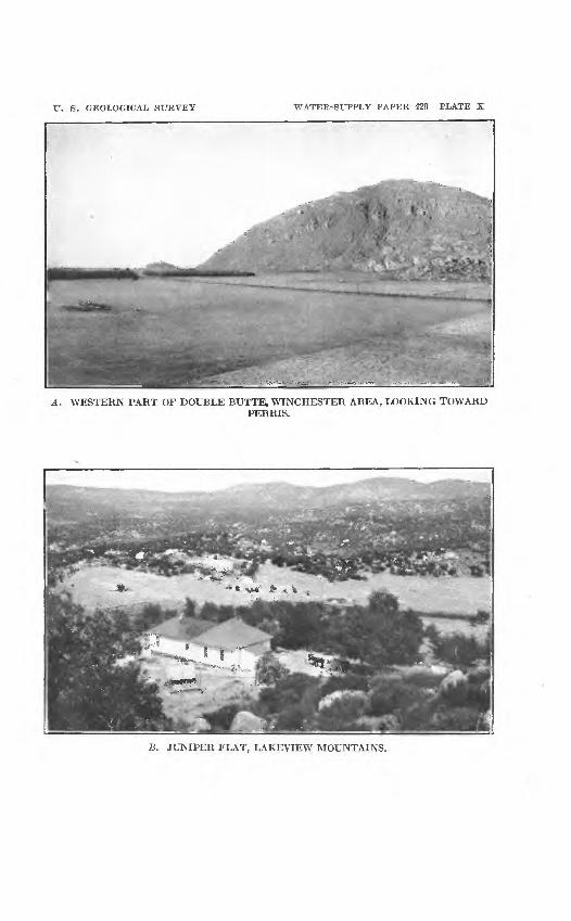
U. S. GEOLOGICAL SURVEY WATER-SUPPLY PAPER 429 PLATE X
A. WESTERN PART OF DOUBLE BUTTE, WINCHESTER AREA., LOOKING TOWARDPERRIS.
B. JUNIPER FLAT, LAKEVIEW MOUNTAINS.

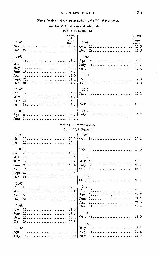
WHSTCHEST-EB AREA.
Water levels in observation icells in the Winchester area.
Well No. 55, 3J miles west of Winchester.
[Owner, F. H. Martin.]
39
1905. Nov. 10...............Dec. 22 .............
1906. Jan. 29 .............Mar. 16 .............May 12 .............June 28 .............A nff 4Sept. 27 .............Dec. 21.............
1907. Feb. 14.............May 18 .............Aug. 31 .............
1908.A r\v OQ
June 25 .............
1905. Nov. 10 .............Dec. 22. ............
1906. Jan. 29 .............Mar. 16 .............May 12 .............June 28 .............Aug. 4 .............Sept. 27 .............Dec. 21 .............
1907. Feb. 14.............May 18 .............Aug. 30 .............
1908. Apr. 23 .............
Aot 1 ^
Dec. 28.............
1909. Apr. 2 .............Julv 11.............
Depth of
water (feet).
........... 18. 2
........... 18. 6
........... 17. 2
........... 16.2
........... 16.8
........... 16. 7
........... 17.0
........... 17.417 Q
........... 15. 9
........... 14. 7
........... 15. 9i a *j
........... 15. 7
........... 16.2
We!! No. 63, £
[Owner, W.
........... 20. 0
........... 20. 4
........... 20. 2
........... 19.5
........... 18. 7
........... 20. 4
........... 19.6
........... 19.5
........... 19.3
........... 18.4
1 Q f\
1 Q O
........... 18.0
........... 18.5
........... 19.4
........... 19.3
........... 18.5
........... 19.2
1908. Oct. 15 ...........Dec. 28. ..........
1909. Apr. 2 ...........July 11 ...........OH 14
1910. Feb. 3...........Aug. 10 ...........
1911.
1915. Nov. 8 ...........
1916. July 30 ...........
it Winchester,
S. Haslam.J
1909. Oct. 14...........
1910. Feb. 3...........
1912.May 18 ...........July 30 ...........Oct. 18 ...........
1913. Oct. 18...........
1914. Feb. 5...........Apr. 17...........June 25 ...........A no1 14
Nov. 21 ...........
1915. Oct. 31 ...........
1916. May 6 ...........Aug. 1 ...........Nov. 15 ...........
Depth of
water (feet).
............. 16.5170
Ifi 0~i a *j
............. 17.6
............. 17.0
............. 17.0
............. 18. 2
............. 20. 2
............. 17.7
............. 20. 1
............. 19.0
............. 20. 2
............. 20. 7
............. 24. 5
............. 23.7
............. 23. 3
............. 24. 7
............. 21.1
............. 21.3
............. 22. 4
............. 21.0
............. 16. 5
............. 17.4
............. 17.9
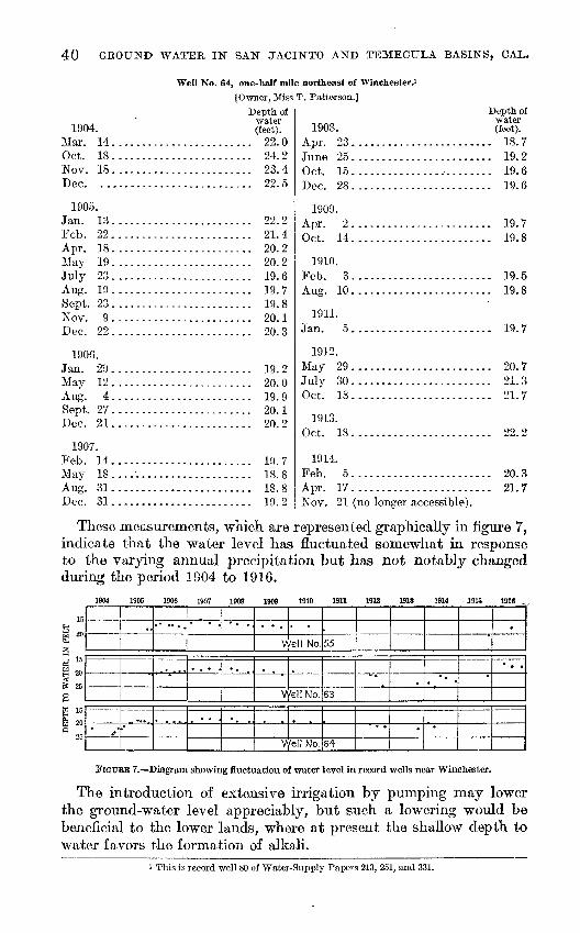
40 GROUND WATEE, IN SAN JACINTO AND TEMECULA BASINS, CAL.
Well No. 64, one-half mile northeast of Winchester.*
[Owner, Miss T. Patterson.]
1904. Mar. 14 ............Oct. 18 ............Nov. 18............Dec. ..............
1905. Jan. 13 ............Feb. 22............Apr. 18 ............May 19 ............July 23 ............Aug. 19 ............Sept. 23 ............Nov. 9 ............Dec 22
1906.Tan 90
Mav 19
Sept. 27 ............Dec. 21............
1907. Feb. 14. ...........May 18....'........Aug. 31 ............Dec. 31 ............
Depth of water (feet).
............ 22.0
............ 24. 2
............ 23. 4
............ 22. 5
............ 22.2
............ 21.4
............ 20. 2
............ 20. 21Q fi1Q 7
1Q 8
20 190 3
-|Q 0
............ 20.019 9
............ 20.1
............ 20. 2
19 71 Q Q
............ 18.8
............ 19.2
1908. Apr. 23 ......................
Oct. 15.......................Dec. 28. .....................
1909.A nr 9
Ort 14
1910.Feb. 3 ......................Aug. 10 ......................
1911.Jan. 5 . .....................
1912. May 29 ......................July 30 ......................Oct. 18......................
1913.Oct. 18......................
1914.Feb. 5......................Apr. 17 ......................Nov. 21 (no lonsrer accessible1).
Depth of water (feet).
. . 18. 7
.. 19.219 fi19 fi
19 710 Q
.. 19.5
.. 19.8
. . 19. 7
. . 20. 7
.. 21.3
.. 21.7
.. 22.2
. . 20. 3
.. 21.7
These measurements, which are represented graphically in figure 7, indicate that the water level has fluctuated somewhat in response to the varying annual precipitation but has not notably changed during the period 1904 to 1916.
15
B ongs;TO WATER. ]
En S 5
W 15
a 20Q
25
..
.
' . " * «
^ ^
* .
.
.
V
\A
/ell No.
/ell No.
Well No.
55
63
64
" *
*
.
* .
*
.
. .
FIGURE 7. Diagram showing fluctuation of water level in record wells near Winchester.
The introduction of extensive irrigation by pumping may lower the ground-water level appreciably, but such a lowering would be beneficial to the lower lands, where at present the shallow depth to water favors the formation of alkali.
i This is record well 80 of Water-Supply Papers 213, 251, and 331.
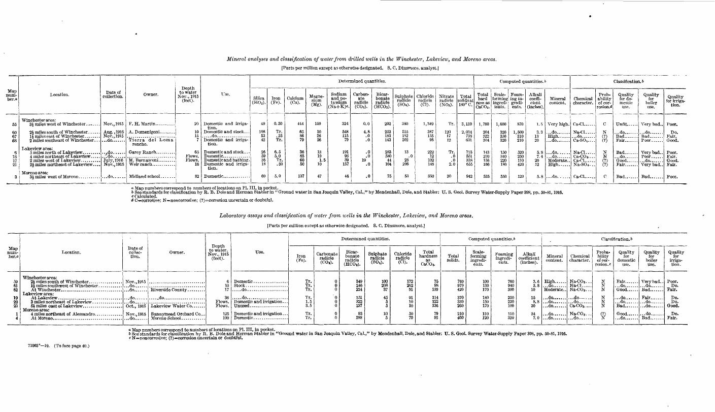
Mineral analyses and classification of water from drilled wells in the Winchester, Lakeview, and Moreno areas.
[Parts per million except as otherwise designated. S. C, Dinsmore, analyst.]
Map num ber .0
55
60 6768
B 15 17 21
3
Location.
Winchester area: 3i miles west of Winchester .......
2 miles southeast of Winchester. . .
Lakeview area: 5 miles north of Lakeview. ........
2| miles northeast of Lakeview. . . .
Moreno area:
Date of collection.
Nov., 1915
Aug., 1916 Nov., 1915...do.......
...do......
.."do......Julv, 1916 Nov., 1915
...do......
Owner.
F.H. Martin... .......
Tierra del Loma rancho.
Depth to water
Nov., 1915 (feet).
20
10 15
7
65Flows. Flows.
16
82
Use.
Domestic and irriga tion.
Domestic and stock. . . .....do.................Domestic and irriga
tion.
Domestic and stock. . . Domestic..............Domestic and bathing. Domestic and irriga
tion.
Determined quantities.
Silica (SiOg).
49
108 53 42
26 59 3618
69
Iron(Fe).
0.50
Tr. .25 Tr.
6.5 5.0Tr, .30
5.0
Calcium(Ca).
414
65 86 79
36 85 60 50
137
Magne sium(Mg).
159
10 26 26
13 19 1.5
10
47
Sodium and po tassium
(Na+K)c.
324
548 115 79
191 93 39
157
46
Carbon ate
radicle (C0»).
0.0
4.8 .0 .0
.0
.0 19
.0
.0
Bicar bonate radicle
(HCO>).
202
253 183 143
283 580 44
104
75
Sulphate radicle(S04).
380
5151S2 202
13 .0
28 206
53
Chloride radicle (Cl).
1,349
387 155 98
222 12
102 146
350
Nitrate radicle (NO.).
Tr.
120 17 12
Tr. .0 .0
2.0
30
Total solids at 180° C.
3,110
2,014738 631
715 551 338 655
942
Computed quantities. 6
Total hard
ness as CaCOs.
1,760
204 322304
143 290 156 166
535
Scale- forming ingred ients.
1,600
320 350 320
150 340 220 180
550
Foam ing in gredi ents.
870
1,500 310 210
520 250 110 420
120
Alkali coeffi cient
(inches).
1.5
3.3 13 20
5.8 7.4
2012
5.8
Mineral content.
Very high.
...do....... High...... ...do.......
...do......
...do.......Moderate. . High......
...do......
Classification. 6
Chemical character.
Ca-Cl......
Na-Cl..... ...do....... Ca-SO 4....
Na-Cl..... Ca-COs-... Ca-Cl...... Na-SO4- ..
Ca-Cl......
Prob ability of cor-
rosion.<J
C
N (?) (?)
N N (?) (?)
C
Quality for do mestic
use.
Unfit......
...do.......
Fair.......
Bad....... ...do.......Good......
Bad.......
Quality for
boiler use.
Very bad..
...do.......
Poor......
Very bad.. Poor.........do....... Very bad-
Bad.......
Quality for irriga
tion.
Poor.
Do.Fair. Good.
Poor. Fair. Good. Fair.
Poor.
« Map numbers correspond to numbers of locations on PI. IIL in pocket.6 See standards for classification by B. B. Dole and Herman Stabler in " Ground water in San Joaquin Valley, Cal.," by Mendenhall, Dole, and Stabler: IT. S. Geol. Survey Water-Supply Paper 398, pp. 50-81,1916.c Calculated.d C=corrosive; N=noncorrosive; (?)=corrosion uncertain or doubtful.
Laboratory assays and classification of water from wells in the Winchester, Laleview, and Moreno areas.
[Parts per million except as otherwise designated. S. C. Dinsmore, analyst.}
Map jium- ber.ffi
59 61 62
19 2223
1 4
Location.
Winchester area:
Lakeview area:
Moreno area:
Date of collec tion.
Nov., 1915...do..........do.......
...do......
...do.......Oct., 1915
Nov., 1915 ...do.......
Owner.
.....do....................
Sunnymead Orchard Co...
Depth to water, Nov., 1915
(feet).
6 10 17
36 Flows. Flows.
125 100
Use,
Stock..........................do.....................
.....do....................Domestic and irrigation. . .
Domestic and irrigation . . .
Determined quantities.
Iron(Fe).
Tr. Tr. Tr.
Tr. 1.5 3.5
Tr.Tr.
Carbonate radicle (OOi).
0 00
0 00
0 0
Bicar bonate radicle (HC08).
349 246 224
151322 237
93288
Sulphate radicle (SO*).
100 208 37
45 5 5
105
Chloride radicle
(Cl).
172 262 91
91 10 10
50 70
Total hardness
as CaCOs.
75 98
139
114 122 136
79 95
Computed quantities. 6
Total solids.
760 970 420
370 330 260
210 400
Scale- forming ingredi
ents.
100 130 170
140150 170
110 120
Foaming ingredi
ents.
760 940 300
250 220 100
110 320
Alkali coefficient (inches).
3.6 3.8
10
158.8
20
34 7.0
Classification. 5
Mineral content.
High......
Moderate..
...do.......
...do.......
...do.......
...do.......
...do.......
Chemical character.
Na-COs- -- Na-Cl.....Na-COs...
...do......
...do....... Ca-CO3....
Na-COs... ...do.......
Proba bility of cor
rosion, c
N N N
N NN
%
Quality for
domestic use.
Fair..........do....... Good......
...do.......
...do.......Bad.......
Good.........do.......
Quality for
boiler use.
Very bad.. ....do....... Bad.......
Fair....... ...do..........do.......
...do.......Bad.......
Quality for
irriga tion.
Poor. Do.
Fair.
Do. Do.
Good.
Do. Fair.
<* Map numbers correspond to numbers of locations on PL III, in pocket.& See standards for classification by R. B. Dole and Herman Stabler in "Ground water in San Joaquin Valley, Cal.," by Mendenhall, Dole, and Stabler: \J. 8. Geol. Survey Water-Supply Paper 398, pp. 50-81,1916.c N=noncorrosive; (?)»*eorrosion uncertain or doubtful.
71065° 19. (To face page 40.)


WINCHESTER AREA. 41
IRRIGATION-. *
In 1890-91 a canal was constructed along each side of Winchester Valley by the San Jacinto Valley Water Co., and during the early nineties these canals supplied water to a number of orchards in the region. With a head of 250 miner's inches of water at San Jacinto it was, however, possible to deliver only 50 inches to the lands near Winchester, because of excessive losses from the earthen canals, and during the series of dry years beginning in 1893-94 they were aban doned. After this project was given up some efforts were made to obtain water for irrigation by means of wells and steam pumping plants, but the expense proved to be prohibitive, and Winchester Valley largely reverted to dry farming. Within recent years dis tillate engines and electric power have been utilized and a considerable acreage has been planted to alfalfa. Several hundred acres of decidu ous trees chiefly apricots and apples have also been set out on the slightly higher lands on the valley border southeast and northeast of Winchester.
Three or four wells drilled several years ago on the Domenigoni ranch, near the center of Domenigoni Valley, obtained water at a depth of 8 feet and encountered bedrock at 80 feet. They yielded fairly large supplies of water but the plans for their utilization and for the irrigation of alfalfa had not been carried out in 1915.
QUALITY OF WATER.
Analyses and laboratory assays of seven well waters in the Win chester area were made to ascertain the general character of the ground water in this region and the results are reported in the table opposite page 40.
The analytical results show that the waters are rather highly min eralized. The water of lowest mineral content (No. 62) from the county roadside watering well at Winchester, contains 420 parts per million of solids in solution, and although good for domestic use is bad for use in boilers and only fair for irrigation, because it contains rather large amounts of bicarbonate and chloride. The water from well No. 55, containing 3,110 parts per million of solids, is distinctly salty and has been used with little success in irrigating alfalfa.
ALKALI.Though water is found near the surface in the Winchester area
and conditions thus favor pumping, the advantage is largely offset by the fact that both the water and the land in the lower tracts are somewhat alkaline. Large acreages of the lower lands are unsuited to grain raising because of the alkali and have been given over to the pasturage of cattle and hogs. Alkali has accumulated chiefly in the lowland southeast of Winchester and in the southwestern part of Domenigoni Valley. The construction of drainage ditches might benefit these lands somewhat, but the natural slope is so slight that the possibility of overcoming the alkali by drainage alone seems doubtful.
42 GROUND WATER IN SAN JACINTO AND TEMECULA BASINS, GAL.
LAKE VIEW AKEA.
LOCATION AND CHARACTER.
The Lakeview area includes the valley lands north and northwest of Lakeview Mountains. In most places the bordering hills and mountains rise abruptly from the flat valley land, but to the north west, along the border of the Badlands, the surface rises gradually to a low divide near Moreiio, beyond which flood water flows west ward and southward to Perris Valley. South and east of Lakeview, also, wide alluvial slopes intervene between the flat valley land and the steep, rocky slopes of Lakeview Mountains.
San Jacinto River, continuing northwestward from San Jacinto, normally traversed the lowlands in a shallow, meandering -channel to the northern and lowest part, known as Brownlands, and there spread out in a shallow lake from which the water flowed south- westward past Lakeview and across Perris Valley. Within recent years the channel has been straightened and leveed through a part of the lowland, however, and in 1915 a drainage district was formed for its further improvement. During the heavier storms of winter and until well into the summer the channel carries some water, but in the fall the flow usually ceases and the river is reduced to a series of long, shallow stagnant pools.
Nearly all the land in the lower, area, near the course of the river, consists of dark, rather heavy soil, evidently an alluvium deposited over the flat lands by the flood waters. In the northern part of the lowlands the clays and sands of the adjacent Badlands have contrib uted to the soils of the neighboring valley lands. On the slopes that border the lowlands on the west and south the soil is coarser and consists of the granitic wash from the adjacent slopes.
ARTESIAN AREAS.
Until recent years it was thought that flowing artesian wells were not obtainable in the San Jacinto area northwest of Casa Loma. About 1911, however, wells that were put down several miles farther north obtained artesian flows, and the wells sunk prior to November, 1915, indicate that the limits of the flowing-well area are approxi mately as shown in Plate III (in pocket). % In this area the formations yielding flowing water are as a rule finer grained than they are farther upstream, near San Jacinto, but two or three wells near Brownlands have passed through thin beds of gravel containing pebbles the largest of which were half an inch in diameter. The artesian pressure in these wells, as in those near San Jacinto, is doubtless due to the manner in which layers of sand and gravel are confined between layers of more impervious, finer sand and clay. (See fig. 2.)
The logs of two flowing wells put down in the lowland near Casa Loma about 1900 (fig. 8) show the approximate thicknesses of the water-bearing strata penetrated near that place.

LAKEVIEW 43
feel
Clay
360362368|
640
ata
Coarse sand; small artesian flow j
Blue clay
Sand, water
Blue day-
Sand; water
Sandy c/ay
Cemented sancf
Fine ssndf water
Clay
Sand, w&ter
ClaySand; water
Blue c/ay
Cemented ssncf
C/ay ^Sarid \ClayCoarse sand; water ;
C/ay
Sandfdry
Clay
Sand, water f-C/ay , * Sand, a /ittle water
Cemented sand
Ssnd, dry
Cement&d sancf
Clay
Sand, ffry
Clay
Sand', dry
Clay
Sand,a littte~w#tisi'.
Clay
Sand; water \C/ay
Sand; water ;
Clay
Sandj water,
Clay
Sand; water >
Clay
Sand, much
In the vicinity of Brownlands the average depth to flowing artesian water is about 225 feet. A test well put down to a depth of 1,500
^ feet found no good water bearing beds below 250 feet, the material pene trated for practically the entire depth below the lowest water sand being a clay gumbo. Consider able gas, probably marsh gas, is associated with the water. From wells in the northern part of the low land several families were supplied with gas for cook ing and heating during one winter. A well that was being drilled near the low est part of the valley en tered a pocket of gas, which threw out the cas ing and nearly wrecked the drilling machine. The pressure was soon relieved, however, and in the fall of 1915 there was no evi dence of gas at the place.
Along the river channel about 2 miles west of Lakeview warm springs, early known as the Hot Springs of the Pilares, issue in a tule area several acres in extent. The water was at one time piped to a bath house on the higher land and the property was con ducted as a bathing resort. Within recent years two wells drilled on the ad jacent slopes a few feet above the springs have obtained artesian flows of
warm water, presumably from the same source as that which feeds the original springs. In 1915 a large cemented bathing pool was supplied by one of these wells, which yielded a flow of 15 or 20
38 B
33&
mz
Sand, water
Clay
Sand, waterFi'ne sand '- and shiny mudi two smal or wood
Hard clff
Flowed most strongly at a depth of I6O-/74 feet; most oF the water furnished by sands between 3/0and 368 feet. '
FIGURE 8. Logs of flowing artesian wells near Casa Loma.
44 GROUND WATER IN SAN JACINTO AND TEMECULA BASINS, OAL.
gallons a minute at a temperature of about 80° F. Analysis of water from this well (No. 17; see table facing p. 40) shows that it is a moder ately mineralized calcium-chloride water, chloride forming nearly one-third of its total mineral content of 338 parts per million.
GROUND-WATER LEVEL.
Throughout the lower parts of the Lake view area ground water is within 10 feet of the surface. In the northern part of the valley, toward Moreno, the depth appears, from the few available records of wells, to increase approximately with the rise of the land, indicating that the water table is nearly horizontal. On the slopes near Lake- view the depth to water increases at a rate notably less than that at which the surface slopes upward toward the mountains. Records of the depth to water in three wells near Lakeview from 1904 to 1916 are given in the following tables:
Water levels in observation ivells in the Lakeview area, Cal.
Well No. 18, at Lakeview.i
[Owner, Albert McDonald (formerly owned by K. D. Harger).]
1904. Mar. 12 ............Nov. 19 ............Dec 161905.
Feb. 22. ...........Mar. 26............Apr. 19 ............May 19 ............
July 22 ............Aug. 18 ............Sept. 22 ............Nov. 9 ............T)pr- 93
1906. Jan. 30 ............May 11 ............June 29 ............Aug. 3............Sept. 26 ............ Dec. 20............1907.
Feb. 13............May 17............Aug. 30 ............Dec. 31 ............1908.
Apr. 22 ............
Oct. 16 ............Dec. 29 .............
Depth to water (feet).
............ 29.0
............ 30. 190. 8
............ 29.4
............ 29.2
............ 29.0
............ 28.9
............ 28.8
............ 28.9
............ 29.1on o
9Q 4
OQ f!
............ 29.5
............ 29.2
............ 29.2
............ zy. &
............ 29.7
............ 29. 3
............ 28. 7
............ 29.1on q
........... 28. 8............ 28. 8............ 29. 1........... 29.0
1909. Apr. 3 ......July 12......Oct. 15 ......
1910. Feb. 3......Aug. 11......
1911. Jan. 6 .......
1912.May 28 .......July 27.......Oct. 18 .......
1913. Oct. 18 .......
1914. Feb. 5 .......Apr. 17.......
Aug. 13 .......Sept. 16 .......Nov. 20 .......
1915. May 23 .......Oct. 30 .......
1916.
July 30 .......Nov. 16.......
Depth to water (feet).
................. 28. 7
................. 28.7
................. 28.8
9Q R
9Q R
................. 28. 7
................. 28. 6
................. 29. 0
................. 29. 3
OA A
................. 29. 9
...../........... 29.7
................. 29. 9
................. 30. 0
................. 30. 4
................. 29. 6
................. 28. 7
................. 30. 6
................. 30. 7
................. 30. 9This is record well 85 of Water-Supply Papers 213, 251, and 331.

LAKEVIEW AREA.
Well No. 19, at Lakeview.
[Owner, Riverside County.]
45
1905. Nov. 9 ........Dec. 23........
1906. Jan. 30 ........Mar. 16........May 11 ........June 29 ........Aug. 3........ Sept. 26 ........Dec. 20 ........
1907. Feb. 3 ........May 17 ........Aug. 30 ........Dec. 31 ........
1908.
June 24........Oct. 16 ........Dec. 29........
1909. Apr. 3 ........July 12 ........Oct. 15 ........
1905. Nov 9Dec. 23........
1906. Jan. 30 ........Mar. 16 ........June 29 ........Aug. 3 ........Sept. 26........
1907. Aug. 30........
1908.
June 24 ........Oct. 16 ........Dec. 29 ........
Depth of water (feet).
................ 34. 8
................ 34.9
................ 34. 9
................ 34.5
................ 34.6
................ 34.5
................ 34.0
................ 34. 9
................ 34. 9
................ 34. 6
................ 34. 2
................ 34.7
................ 34.3
................ 34.0
................ 34. 2
................ 34. 3
................ 34.2
................ 33.9
................ 33.8
................ 34.0
Well No. 20, 3 mile
[Owner, Lake^
................ 19.2
................ 19.3
1Q 4
............... 18.5
............... 19.2
............... 19.2
............... 19.2
............... 19. 1
............... 19. 0
............... 19.4
............... 19.1
1910. Feb. 4.............Aug. 11 .............
1911.
1912. May 28 .............Oct. 18 .............
1913. Oct. 18 .............
1914. Feb. 5.............Anr 17
June 24 .............Aug. 13. ............Sept. 16 .............Nov. 20.............
1915. May 23 .............Oct. 31 .............
1916.
July 30 .............Nov. 16.............
s east of Lakeview.
iew Water Co.]
1909. 'Apr. 3. ............July 12 .............Oct. 15 .............
1910. Feb. 4 .............Aug. 11.............
1911.
1915. Nov. 3.............
1916. July 30.............
Depth ofwater (feet).
qq 7........... 33.8
........... 33.8
........... 33.4
........... 34.2
04 7
q4. 7
M An A rt
qe rt
........... 35.2
........... 35.1
34 3qc 7
qc A
........... 35.7
........... 35.7
........... 18.8
........... 18.8
........... 18. 9
........... 18. 8
........... 18.7
........... 18. 8
........... 19.0
........... 19.0
46 GROUND WATER IN SAN" JACINTO AND TEMECULA BASINS, CAL.
These records, which are shown graphically in figure 9, indicate that there has been little fluctuation in the ground-water level in the lowland area near Lakeview during the years of observation. A com-
TO WATER, IN FEE! IS 8 3 &
SB isW 20Q
_4_[
- -
V
./ell No.
Well No.
Well No.
18
Is"
20
1
,
FIGURE 9. Diagram showing fluctuation of water level in record wells near Lakeview.
parison of the measurements of depth to water in a number of wells near Lakeview in March, 1904, and, in November, 1915, shows, how ever, a general rise of about 10 feet in the water level on the slopes back of Lakeview. This rise is indicated in Plate III (in pocket) by the relative positions of the lines showing depths to water of 40 and 60 feet in 1904 and in 1915. The rise probably was not progressive throughout the period but was due to the f airly wet winters of 1913-14 and 1914-15.
IRRIGATION.
About 1900 an attempt was made to supply water to irrigate lands in the Lakeview area by means of flowing wells sunk near Casa Loma. A canal was constructed along the southern side of the valley, and for two or three seasons water from the wells was distributed to a number of tracts of orchard. The flowing wells failed to yield sufficient water, however, and as pumping by steam plants proved too expensive the project was abandoned. In more" recent years, since the flowing wells were obtained in the lands farther north, near Brownlands, a number of 4-inch and 6-inch wells were put down, a power plant and air lifts were installed to augment the natural flow, the lower lands were diked to prevent their being overflowed by San Jacinto River, and an attempt was made to colo nize the lands. The project was not successfully carried through, and a break in the dike early in 1915 allowed a considerable part of the lands to be flooded. In the fall of 1915 water in apparently ample quantity was being obtained by several private pumping plants on the slopes near Lakeview and in the lower lands to the northeast, and small fields of alfalfa and other crops were being watered. Most of the cultivated land in the northern part of the region was devoted to grain raising, and by far the most of the low land was given over to the grazing of sheep and cattle.
The greatest development of irrigation has been southwest of Lakeview, on the Nuevo ranch. In the fall of 1915 three large, electrically operated pumping plants here supplied water for the
MORENO AREA. 47
irrigation of about 400 acres of deciduous fruit trees, and pipe lines were being laid to additional lands that were being set out to orchards. Water was found at depths of 40 to 60 feet in sand and gravel along the southern border of the lowlands adjacent to San Jacinto River.
QUALITY OF WATER.
In connection with the study of ground water in the Lakeview area, samples of water from seven wells were collected for chemical examination. The results of the chemical examination of these waters are tabulated opposite page 40.
The flowing water from well 23 contains only 260 parts per million of solids. The maximum solids found in the waters sampled was 715 parts per million in water from well 6, at the Garey ranch, in the northwestern part of the area. The flowing water at Brownlands (well 15) is calcium-carbonate in character, and is sufficiently high in iron to be bad for domestic use and sufficiently high in bicarbonates to be classed as only fair for use in irrigation. Well 21, south of the river channel, yields sodium-sulphate water of fair quality for domestic use and for irrigation, but because of its excessive amount of foaming constituents is classed as very bad for use in boilers. The waters from wells 19 and 22 are good for domestic use and fair for irrigation; No. 23 has been classed as bad for domestic use on account of its high content of iron, but is good for irrigation. All three can be used successfully in boilers.
The waters of wells sunk on the slopes bordering the valley are somewhat better than those of the lowland wells tested. Analyses of the upland waters are not available, but water from one of the wells on the Nuevo ranch is said to contain about 350 parts per million, of solids in solution.
ALKALI.
Heavy deposits of alkali have not been formed in the lowlands of the Lakeview area, but along the course of the river north and west of Lakeview the soil is rather alkaline and is given over to pasturage. Possibly ditching and careful cultivation might fit this land for some of the more resistant forage crops, such as sugar beets, but the land is so flat that successful leaching out of the salts by drainage would probably be very difficult.
MORENO AREA.
LOCATION AND CHARACTER.
The Moreno area is at the northern end of the San Jacinto basin, between the hills that culminate in Mount Russell, on the south, and Box Spring Mountains and the Badlands, which together form the northern border of the basin. To the east the land slopes gently downward from an almost imperceptible drainage divide near Moreno, to the lowlands of San Jacinto River. To the west the slope is equally gradual down to Alessandro Valley, which constitutes the upper part of the Perris area. .
48 GROUND WATER IN SAN JACINTO AND TEMECULA BASINS, CAL.
The Moreno area as a whole forms a great outwash slope that extends along the base of Box Springs Mountains and the hills farther east. The surface of this slope is, however, interrupted by half-buried outliers of the granitic hills, and though in most places the unconsolidated deposits are deep, in a few the underlying bed rock has been reached by wells. The depth at which rock is reported in wells examined is indicated in Plate III (in pocket).
Most of the soil is a fairly coarse and loose material derived from the decay of the granitic rocks of near-by hills. In the northeastern part of the area the older clays and gravels of the Badlands produce a somewhat heavier soil.
GROT7KD-WATER LEVEL.
At Moreno the depth to water in 1915 was fully 100 feet, but to the southwest it was less, being about 60 feet in the eastern part of Alessandro Valley. Westward from Moreno the depth to water is somewhat greater, though near Armada it is influenced by the pres ence of bedrock. At this latter settlement the water level was about 90 feet below the surface in the fall of 1915, and thence the depth apparently decreased gradually to about 60 feet near Box Springs. Northward, as the ground rises toward the Badlands, the depth to water increases. The slope of the ground-water table in this region is also very appreciable, so that at a well north of Moreno, where the surface is 300 feet above the settlement, the depth to water had increased only 125 feet, being 225 below the surface in the fall of 1915. At the base of the Badlands some test wells have ob tained small quantities of water in the sandy shales of the older formations at 80 to 100 feet, but other wells have found these mate rials practically dry to depths of nearly 200 feet. Two deep wells that were drilled for oil in the Badlands 4 miles northeast of Moreno are said to have struck small flows of warm artesian water. Two deep test wells at Moreno obtained artesian water which rose within a few feet of the surface and which had a temperature of about 120° F. The following partial analyses of water from these wells, and also from a pumping-plant well (No. 9 of PL III, in pocket) have been furnished by Mr. P. J. McCarty, manager of the property:
Partial analyses of well ivaters on E. E. Hendricks estate, Moreno area.
[Collected in 1907; Edward S. Babcock, analyst. Parts per million.]
No
West well.
4364
1301588
. 5. a
East well.
8.8170996.7
213
41116116
6.9179
a Numbers of location on PL III (in pocket). & Reported as carbonate in original analysis. e By summation.
MOEENO AEEA.
The waters seem, from these partial analyses, to be sodium- chloride in character, though the amounts of chloride present prob ably do not seriously affect their use for irrigation.
Feet
I7O 172
202 2CW
I5s
260
330
350
IS-^ ~
ISi§3UsTi:»I:"^""-"oV-
i^
Hite
8SiM=
-'^ ^"
is
iffi5§s
Feet
05
Soil grave/- 7Sand c/ay '
Grave!: a little water
Clay
Gravel
Clay
Gravel
C/ay
Coarse gravel .
|=§ 2SS
sli;
1
Clay
Cemented 335 grave/ and sand 3^2 Clay witft stones
363
Water stood at 81 'feet when drilled flSOd or 1909;
*20«2I
i.,67
571 57S
E^
v~
=§!is
-=r^~^S~
3
^
H
HIm^=SHigis?mSg><2£.
mi§us
?a,°^
Hn^^^
Feet
5o/Vand'clay
Sandandclay
||
C^-
187.193
207
Fine gravel 279 Coarse 283gravel
317
5/w<? o'/?^ \b/ack c/ayCparse 333
/^^ 366Jrsvff/
Blue day
Fine ^' 3gravel ^27
:g^J / Vyi, T*-tJ
*f/i/7gp, .gr,?^/-^^1
=§51
i=S
^s:
ffi
=:
=Ei§=:
i^
/7/7P Zt' S3gravel
Blue c/ay
SAI
557
565Granite
589
60O
6 2O
±=:HS
?5?=H:
H|T^.T:im;
i^Hi
^
ffl
H1:1
i^
iHH^r=
==
1=
1
sffl
Feet
SrtcX <T/^»' SI
S»*rf
Clay
Sandf iso
^ 206212
(T/3y _ , with safttf Z^Q
111K-
^/_,.. 27S C' /1?^ E86
290
Sane/ Soo' 310
C/a\s F*Sand 332 G raise! '5^^C/SK i |5^8Gravel '3s/t
366
3S-4- C/d?/ 3|0
3 an*~"~
TS3 <~ , ^'f^j Gravet \30
;oJ?l Cemented *f38
£,p££
ffl
M=s5?s§nw
4-60
!
3;rS
Errd
g3^Sr
SEH^:r=L=r:
^
^
sffl
HsH^H
BHE
1i^
wf-f^g
^^
H
1^^n= '^^^-F^
BH§l
OiJy **98 'ISi
So// owo' c/ay
Sand
C/ay'
Coarse gravel, waterSandy c/ay Fine gravelC/ay
Clay with grai/e/
Sanc/y c/ay Fine grave/Clay with grave/
,Clay /Fine grave/
C/ay with gravelClay
Fine grave/
Clay with grave/ Ft'ne grave/Clay SandSandy c/ay /Gravel Clay Coarse sandCemented c/ayGravelC/aySar/d
C/ay
C/ay with grav-ef
C/ay
EjO ^$Q/£efri&nted $artdSI3Eie; sis'524532
:; :;:- SandC/ay
~=S^
5S/70»sa*
BPI:' D'.^:s
f-'&f
?:& ' °'l°n
~Cemer/ted gr&vet ^Cemented sandCemented gra vel
Mixed sandand gravel
.",X
Granite ^ a fien drilled (I9O6/
Hot water rose in these wells nearly to the surface.
FIGURE 10. Logs of wells in the Moreno area. 71065° 19 WSP 429 4
50 GROUND WATER IN SAN JACINTO AND TEMECULA BASINS, CAL.
The logs of the two hot-water wells, given in figure 10, together with the records of two other wells in the area, show a great predominance of clay in the sections and relatively thin water bearing strata.
IRRIGATION.
In the early nineties an extensive distribution system of vitrified pipe was laid throughout the Moreno area, and lands estimated at about 2,000 acres were planted to deciduous and citrus fruit trees. Water for irrigation was supplied for several years through a canal of the Bear Valley system, but shortage due to dry years and the increasing demands of orchards in the neighborhood of Redlands, which had prior water rights, curtailed the supply to the Moreno region. Many of the orchard trees died and have long since been removed, and the land is given over to its early use for raising grain. A part of the orchard lands, however, has been kept supplied with water brought from Mill Creek by a tunnel southward through the divide, and in 1915 about 300 acres of citrus trees were watered from this source. A pumping plant in the lower part of the area supplied 80 miner's inches, or 720 gallons per minute, for the irrigation of additional orchards. A considerable acreage of alfalfa was also watered by a pumping plant somewhat farther south, in the lowest lands of the area.
QUALITY OF WATER.
Samples of water from three wells in the Moreno area (wells 1, 3, and 4 of PL III, in pocket) were collected for chemical examination, the results being included in the table of analyses and laboratory assays opposite page 40.
The analyses show that the water of well No. 1 contains only 210 parts per million of total solids but has 50 parts per million of chloride and 93 parts per million of bicarbonate. Its alkali coeffi cient is 34 inches and it is therefore classed as good for irrigation.
The water of well 3, at Midland school, is poor for irrigation. It contains 942 parts per million of total solids, of which 350 parts are chloride. Well 4, at Moreno school, contains 400 parts of solids, but its quality for irrigation is fair, because the solids consist chiefly of bicarbonates, which are not so objectionable in waters to be used for irrigation as the chlorides, sulphates, and normal carbonates.
PEEEIS AREA.
LOCATION AND CHARACTER.
The Perris area embraces a stretch of the valley land 3 to 4 miles wide extending from the northwest rim of the San Jacinto basin at Box Springs southward through Alessandro- and Perris valleys to the low divides that separate the Perris Valley from Menifee and Win chester valleys. The greater part of the valley north of Perris is
U. S. GEOLOGICAL SURVEY WATER-SUPPLY PAPER 429 PLATE XI
A. SAN JACINTO RIVER NEAR PERRIS.
B. LAND NEAR PERRIS PREPARED FOR SEEDING TO ALFALFA.

PERRIS AREA. 51
shown in Plate IX, A. On the west the area is bordered by granitic slopes that form the rim of San Jacinto basin; on the east its limit is less definitely marked, for northeastward the open land extends uninterruptedly to Moreno, and southeastward the lowland extends up the valley of San Jacinto River, which crosses Perris Valley nearly at right angles. An extension of Perris Valley also embraces open lands between the two main ranges of hills that culminate south of Moreno in Mount Russell. In the south a similar arm extends east ward between Double Butte and the Lakeview Mountains.
In the northern part of the valley lands bedrock crops out in granitic ledges a mile east of Box Springs and also in a small area a mile southeast of Alessandro. Several wells a mile to the south and east of the latter outcrop have also reached bedrock at depths of 76 to 162 feet, as is indicated in Plate III (in pocket). In the valley extension south of Mount Russell the rock forms a number of hills and ledges which indicate that the valley fill is relatively shallow throughout this part of the lowland, but in most places the alluvium appears to be fairly thick, and many wells more than 200 feet deep penetrate only unconsolidated materials.
Along the valley borders in the northern part of the area the soil is derived from the weathering of the neighboring granitic slopes and is fairly loose and sandy. In the lowlands northeast of Perris and in a belt half a mile or more wide 'along San Jacinto River, the soil is finer and darker. The reddish color of the soil in the southwestern part of Perris Valley is due partly to its derivation from dioritic rocks which contain larger amounts of iron-bearing minerals than are con tained in the more common granite.
GROUND-WATER LEVEL.
The total area draining to Perris and Alessandro valleys north of Perris is about 100 square miles, but the slope of the greater part of this area is very gentle and the run-off is so slight that well-defined drainage channels have been cut only in the higher bordering slopes. Even San Jacinto River flows across Perris Valley in a channel only a few feet deep. (See PI. XI, A.) The gently sloping surface requires little grading to fit it for planting to alfalfa (PI. XI, B) and a relatively large proportion of the water that falls within Perris and Alessandro valleys is probably absorbed and aids in replenishing the ground- water supply.
The general character of the valley fill and the relative thickness of the water-bearing layers are shown in the logs of several wells given in figure 11.
In 1904, when information concerning the ground-water level in the Perris region was first collected by the United States Geological Survey, the depth to water varied from about 20 feet in the lower lands to 70 feet in the vicinity of Alessandro. With the extensive
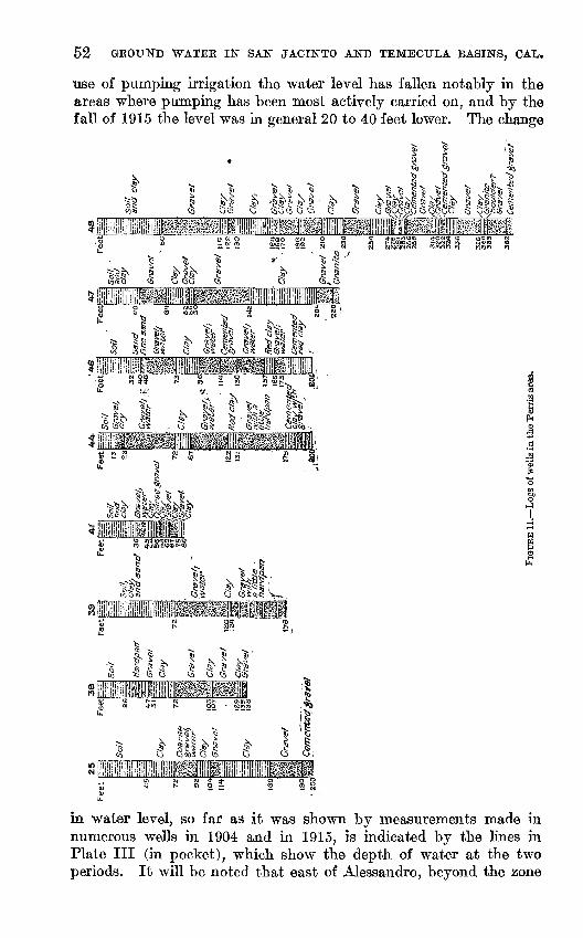
52 GROUND WATEE IN SAN JACINTO AND TEMECTJLA BASINS, OAL.
use of pumping irrigation the water level has fallen notably in the areas where pumping has been most actively carried on, and by the fall of 1915 the level was in general 20 to 40 feet lower. The change
's 111! i III 111,
"V I J1J ' »N, IQ *s. i,"**
^qj G $^ n ^. ^ ?>P ^ ^§1 is!-;; is. ft° t ij ^-"y ^ r^7;>.<t tS^S-C:
?&$!&&S$&\\\
^ s
to lfl3-(OCOON U)Cw SinSSKup t^a;
l
O to-oos G ^
in water level, so far as it was shown by measurements made in numerous wells in 1904 and in 1915, is indicated by the lines in Plate III (in pocket), which show the depth of water at the two periods. It will be noted that east of Alessandro, beyond the zone
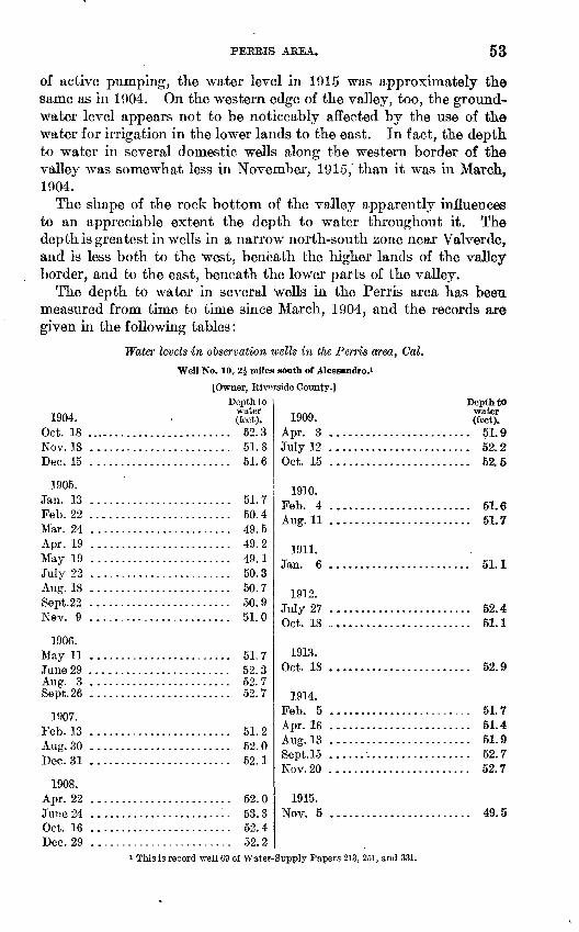
PERRIS AREA. 53
of active pumping, the water level in 1915 was approximately the same as in 1904. On the western edge of the valley, too, the ground- water level appears not to be noticeably affected by the use of the water for irrigation in the lower lands to the east. In fact, the depth to water in several domestic wells along the western border of the valley was somewhat less in November, 1915,' than it was in March, 1904.
The shape of the rock bottom of the valley apparently influences to an appreciable extent the depth to water throughout it. The depth is greatest in wells in a narrow north-south zone near Valverde, and is less both to the west, beneath the higher lands of the valley border, and to the east, beneath the lower parts of the valley.
The depth to water in several wells in the Perris area has been measured from time to time since March, 1904, and the records are given in the following tables:
Water levels in observation wells in the Perris area, Cal.
Well No. 10, Z\ nules south of Alessandro.1
[Owner, Riverside County.]
Depth to., . water 1904. (feet).
Oct. 18 ......................... 52.3Nov. 18 ........................ 51.8Dec. 15 ........................ 51.6
1905.Jan. 13 ........................ 51.7Feb. 22 ........................ 50.4Mar. 24 ........................ 49. 5Apr. 19 ........................ 49.2May 19 ........................ 49.1July 22 ........................ 50. 3Aug. 18 ........................ 50. 7Sept.22 ........................ 50.9Nev. 9 ........................ 51.0
1906. May 11 ........................ 51. 7June 29 ........................ 52. 3Aug. 3 ........................ 52.7Sept.26 ........................ 52.7
1907. Feb. 13 ........................ 51. 2Aug. 30 ........................ 52.0Dec. 31 ........................ 52.1
1908. Apr. 22 ........................ 52. 0June 24 ........................ 53.3Oct. 16 ........................ 52.4Dec. 29 ........................ 52. 2
Depth towater (feet).
Apr. 3 ........................ 51.9July 12 ........................ 52.2Oct. 15 ........................ 52.5
1910. Feb. 4 ........................ 51.6Aug. 11 ........................ 51.7
1911. Jan. 6 51.1
1912. July 27 ........................ 52.4Oct. 18 ........................ 51.1
1913. Oct. 18 52.9
1914. Feb. 5 ........................ 51.7Apr. 16 ........................ 51.4Aug.13 ........................ 51.9Sept.15 ........................ 52.7Nov.20 ........................ 52.7
1915. Nov. 5 49.5
This is record well 69 of Water-Supply Papers 213, 251, and 331.
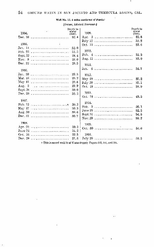
54 GROUND WATER IN SAX JACINTO AND TEMECULA BASINS, CAL.
Well No. 12, 4 miles northeast of Perris.i
[Owner, Edward Poorman.J
1904. Dec. 16
Depth to water (feet).
.. 32.4
1905. Jan. 14 ........................ 32.0Feb. 22 ........................ 31.5Sept. 22 ........................ 28.4Nov. 9 ........................ 29.0Dec. 22 ........................ 29.3
1906.Jan. 30 ........................ 29.3Mar. 16 ........................ 29.2May 11 ........................ 29.6Aug. 3 ........................ 29.9Sept.26 ........................ 30. 0Dec. 20 ........................ 30.2
1907. Feb. 13 ......................... 30. 3May 17 ........................ 30. 3Aug. 30 ........................ 30. 6Dec. 31 ........................ 30.7
1908. Apr. 22 ........................ 30.3Jure 24 ........................ 31.2Oct. 16 ........................ 32.5Dec. 29 ........................ 31.6
Depth to water (Ceet).
. 31.81909.
Apr. 3 ....................July 12 ........................ 32.2Oct. 15 ........................ 32.6
1910. Feb. 4 ........................ 31.3Aug. 11 ........................ 33.0
1911. Jan. 6 34.7
1912. May 28 ........................ 37.2July 29 ........................ 37.1Oct. 18 ........................ 38.9
3913.Oct. 18 49.5
1914. Feb. 5 ........................ 50.1June 25 ........................ 52.3Sept.16 ........................ 54.5Nov.20 ........................ 55.2
1915. Oct. 30 ................'........ 56.0
1916. July 29 ........................ 58. 3
This is record well 70 of Water-Supply Papers 213, 251, and 331.
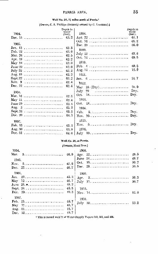
PEERIS AREA. 55
Well No. 24, 2J miles north of Penis. 1
[Owner, C. S. Phillips (formerly owned by C. Lossman).]
1904. Dec. 15
Depth towater(feet).
.. 63.2
1905.Jan. 13 ........................ 63.3Feb. 22 ........................ 63.0Mar. 26 ........................ 62. 5Apr. 19 ........................ 62.2May 19 ........................ 62.0June 20 ........................ 62.0July 22 ........................ 62.2Aug. 19 ........................ 62. 2Sept.22 ........................ 62.2Nov. 9 ........................ 62.4Dec. 22 ........................ 62.4
1906.Mar. 16 ........................ 62.3May 11 ........................ 62.4June 29 ........................ 62.4Aug. 3 ........................ 63.2Sept.26 ........................ 63.3Dec. 20 ............,............ 63.3
1-907.Feb. 13 ........................ 63. 2Aug. 30 ........................ 63. 9Dec. 31 ........................ 64.0
Depth to
1908. SK Apr. 22 ........................ 64. 1Oct. 16 ........................ 65. 2Dec. 29 ........................ 66. 0
1909. July 12 ........................ 67. 6Oct. 14 ........................ 69. 5
1910. Feb. 4 ........................ 69. 8Aug.ll ........................ 72.§
1911. Jan. 6 ........................ 74.7
1912. May 28 (Dry). ................. 76. 0July 29 ..................... Dry.Oct. 18........................ Dry.
1913. Oct. 18........................ Dry.
1914. Feb. 5........................ Dry.Nov. 20. ....................... Dry.
1915. Nov. 5........................ Dry.
1916. July 30.................... Dry.
Well No. 29, at Perris.
{Owners, Hook Bros.]
1904. Mar. 3..............
1905. Nov. 9..............TVr 99
1906.Jan. 29..............May 12. .............June 28. s>. ...........Sept. 26..............Dec. 20... ...........
1907. Feb. 13..............May 17..............Aug. 31..............Dec. 31.. ............
.......... 46. 0
.......... 45. 3
.......... 46.7
.......... 48. 2
.......... 48.5
.......... 49.3
.......... 48. 7
.......... 48. 7
.......... 48.7
.......... 49.7
1908. Apr. 22........................Tn TIP 94
Oct. 15. .......................Dec. 28......-...-.-...-....-..
1909.Anr 9
July 11........................
1915. Nov. 14. .......................
1916.July 30. .......................
49.549.750.250.5
50.350.7
51.0
52.2
This is record well 71 of Water-Supply Papers 213, 251, and 331.
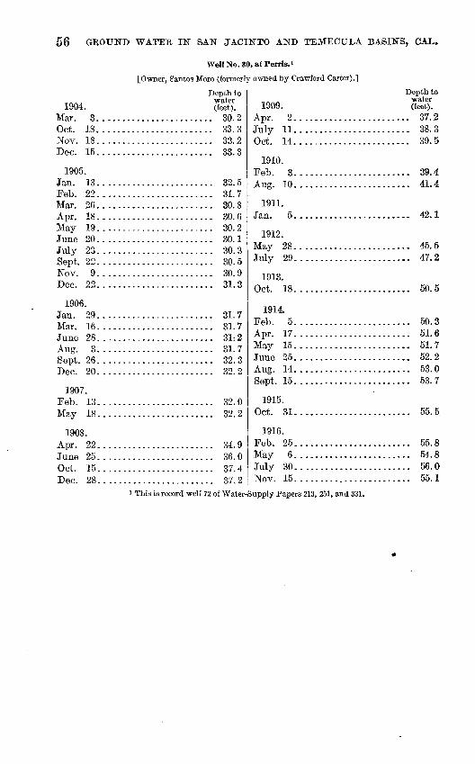
56 GROUND WATER IN SAN JACINTO AND TEMECULA BASINS, CAL.
Well No. 30, atPerris.1
[Owner, gantos Moro (formerly owned by Crawford Carter).]
1904.Mar °.Oct. 18............Nov. 18............Dec. 15............
1905. Jan. 13. ...........Feb. 22............Mar. 26. ...........Apr. 18............May 19. ...........June 20. ...........July 23............Sept. 22. ........... Nov. 9............Dec. 22............
1906. Jan. 29............Mar. 16............June 28. ...........Aug. 3............ Sept. 26. ...........Tiff 90
1907. Feb. 13............May 18............
1908.A r\v 99
Oct. 15............Dec. 28............
Depth to water (feet).
............ 30. 2
............ 33. 3
............ 33. 2
............ 33. 3
............ 32. 5
............ 31.7
............ 30. 8
............ 30. 6
............ 30. 2
............ 30. 1
Oft K
............ 30. 9
............ 31.3
............ 31.7
............ 31.7
01 7
qo q
qo o
............ 32. 0q9 o
14- Q
............ 36. 0qy A
............ 37. 2
1909. Apr. 2.. ..........July 11............Oct. 14............
1910. Feb. 3............Aug. 30. ...........
1911. Jan. 5. ...........
1912.May 28. ...........July 29............
1913. Oct. 18............
1914. Feb. 5............Apr. 17............May 15 ............June 25 ............Aug. 14 ............Sept. 15............
1915. Oct. 31............
1916. Feb. 25............May 6 ............July 30............Nov. 15............
Depth to water (feet).
............ 37. 2
............ 38. 3
............ 39.5
............ 39.4
............ 41.4
............ 42.1
............ 45. 5
............ 47. 2
KA K
............ 50. 3
............ 51.6
............ 51.7
............ 52.2
............ 53. 0
............ 53. 7
............ 55.5.
............ 55. 8
............ 54.8
............ 56.0
............ 55. 1This is record well 72 of Water-Supply Papers 213, 251, and 331.
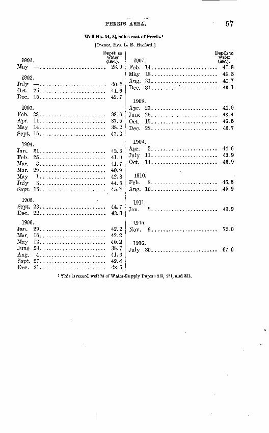
PEREIS AREA. 57
Well No. 34, 3J miles east of Perris.»
[Owner, Mrs. L. R. Harford.]
1901. May . ...........
1902. July ............Oct. 25............Dec. 15............
1903.Feb. 28.. ..........Apr. 11............May 14 ............Sept. 15. ...........
1904. Jan. 31 ............Feb. 28............TWoi* Q
Mar. 29. ...........May 1 ............July 3. ...........Sept. 15............
1905. Sept. 23............Dec. 22............
1906. Jan. 29. ...........Mar. 16.. ..........May 12............June 28 ............Aug. 4 ............Sept. 27. ...!.......Dec. 21. ...........
Depth towater (feet).
............ 28. 9
............ 40. 2
............ 41. 6
............ 42. 7
............ 38. 6
............ 37. 5
............ 38. 2
............ 43.3
41 Q
............ 41.7
............ 40. 9
............ 42. 8
............ 44. 8
............ 45.4
............ 44. 7
............ 43. 0
............ 42. 2
............ 42. 2
............ 40. 2
............ 38. 7
............ 41.6
............ 42. 4
............ 43. 5
1907. Feb 14May 18............Aug. 31. ..........Dec. 31..........'..
1908. Apr. 23.. .........
Oct. 15............Dec. 28...........
1909. Apr. 2...........July 11............Oct. 14............
1910. Feb. 3...........Aug. 10. ...........
1911.
1915. Nov. 9 ...........
1916. July 30............
Depth to water (feet).
............ 41. 8
............ 40. 3
............ 40. 7
............ 43.1
............ 41. 9
............ 43.4
............ 46.5AR 7
............ 44. 6
............ 43.9
............ 46. 9
............ 46. 5
............ 45.9
............ 49.9
............ 72.0
G*7 f\
This is record well 73 of Water-Supply Papers 213, 251, and 331.
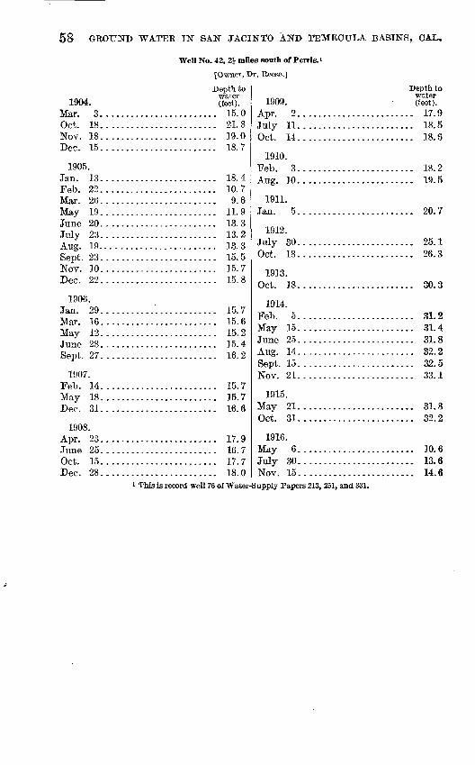
58 GROUND WATEE IN SAN JACINTO AND TEMECULA BASINS, GAL.
Well No. 42, 21 mUes south of Perris. 1
[Owner, Dr. Reese.]
1904. Mar. 3.. ..........Oct. 18. ...........Nov. 18............Dec. 15............
1905. Jan. 13............Feb. 22.. ..........Mar. 26............TVfo-tT- 10
June 20.. ..........July 23.. ..........Aug. 19... ......... Sept. 23............Nov. 10. ...........Dec. 22............
1906. Jan. 29.. ..........Mar. 16............May 12............June 28. ...........CJ_^^4. OfT
1907. Feb. 14............May 18............Dec. 31............
1908. Apr. 23.. ..........
Oct. 15............Dec. 28............
Depth to water (feet).
........... 15.0............ 21.8............ 19.0............ 18. 7
............ 18. 4........... 10. 7........... 9.6............ 11.9............ 13. 3............ 13.2
1Q Q
............ 15. 5
............ 15. 7
............ 15. 8
............ 15.7
............ 15. 6
............ 15. 2
............ 15.4Ifi 9
............ 15. 7
............ 15.71 rt £
............ 17. 9
............ 16. 7
............ 17.7
............ 18. 0
1909. Apr. 2. ...........July 11............Oct. 14............
1910. Feb. 3............Aug. 10............
1911. Jan. 5 ............
1912. July 30............Oct. 18............
1913. Oct. 18............
1914. Feb. 5............May 15............June 25 ............Aug. 14 ............Sept. 15...........Nov. 21............
1915. May 21............Oct. 31...........
1916. May 6............July 30...........Nov. 15............
Depth towater (feet).
............ 17. 9
............ 18. 5
............ 18. 6
............ 18.21Q ^
............ 20. 7
............ 25. 1
............ 26. 3
............ 31. 2
............ 31.4
............ 31. 8
............ 32. 2
............ 32. 5
............ 33. 1
............ 31.8
............ 32. 2
............ 10.6
............ 13.6
............ 14. 6i This is record well 76 of Water-Supply Papers 213, 251, and 331.
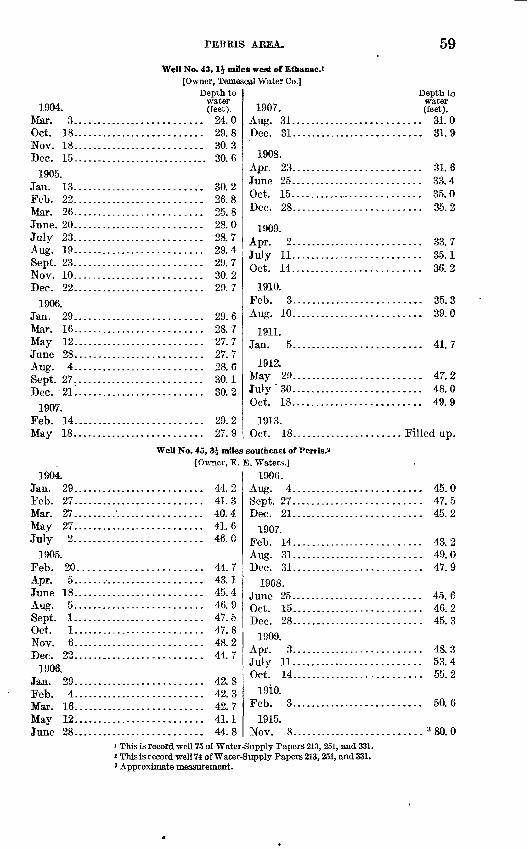
PEBRIS AEEA. 59
Well No. 48,1J miles west of Ethanac.t[Owner, Temescal Water Co.]
1904. Mar. 3....Oct. 18....Nov. 18....Dec. 15.....
1905. Jan. 13....Feb. 22.....Mar. 26June. 20.....July 23.....Aug. 19....Sept. 23.....Nov. 10.....Dec. 22....
1906. Jan. 29Mar. 16....May 12....June 28....
Sept. 27Dec 21
1907. Feb. 14....May 18.....
1904. Jan. 29....Feb. 27....Mar. 27....May 27.....July 2.....
1905. Feb. 20....
June 18....Aug. 5.....Sept. 1.....Oct. 1....Nov. 6....Dec. 22....
1906. Jan. 29....Feb 4Mar Ifi
May 12....June 28....
Depth to water (feet).
..................... 24.0
..................... 29.8
..................... 30.3
....................... 30.6
..................... 30.2
..................... 26.8OK Q
..................... 28. 0
..................... 28.7
..................... 29. 4
..................... 29. 7
..................... 30. 2
..................... 29.7
oq A
..................... 28.7
..................... 27. 7
..................... 27.7
..................... 28.6on ion o
..................... 29.2
..................... 27. 9
Well No. 45, 3i miles[Owner, E.
..................... 44.2
..................... 41.3
....'................. 40.4
..................... 41.6
..................... 46. 0
.................... 44. 7
..................... 43.1
..................... 45. 4
..................... 46.9
..................... 47.5
..................... 47.8
..................... 48.2
..................... 44.7
..................... 42.8
..................... 42.349 7
..................... 41.1
..................... 44.8
1907. Aug. 31................Dec. 31...............
1908. Apr. 23...............
Oct. 15.......... ....Dec. 28................
1909.Apr. 2...............July 11................ Oct. 14................
1910. Feb. 3...............Aug. 10................
1911.
1912. May 29...............July'30................Oct. 18................
1913. Oct. 18...............
southeast of Perris.2E. Waters.]
1906.
Sept. 27................Dec. 21...............
1907. Feb 14Aug. 31...............Dec. 31...............
1908.
Oct. 15...............Dec. 28...............
1909. Apr. 3...............July 11................Oct. 14...............
19iO. Feb. 3................
1915. Nov. 8...............
Depth to Water (feet).
.......... 31. 0
.......... 31. 9
.......... 31. 6
.......... 33. 4
.......... 35. 0
.......... 35. 2
oo 7
Qfi 1
.......... 36. 2
.......... 35.3
.......... 39. 0
41 7
.......... 47. 2
.......... 48. 0
.......... 49. 9
...... Filled up.
.......... 45. 0
.......... 47. 5
.......... 45. 2
AQ f>
.......... 49. 0
.......... 47. 9
.......... 45. 64fi 945 3
.......... 48. 3
.......... 53. 4
.......... 55. 2
.......... 50. 6
.......... 3 80. 01 This is record well 75 of Water-Supply Papers 213, 251, and 331.2 This is record well 74 of Water-Supply Papers 213,251, and 331.3 Approximate measurement.
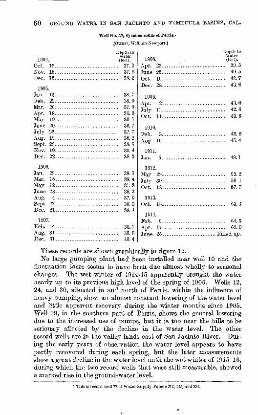
60 GROUND WATER IF SAN JACINTO AND TEMECULA BASINS, CAL.
Well No. 51,4i rrules south of Perris.i
{Owner, William Newport.]
1904. Oct. 18.............Nov. 18.............Dec. 15.............
1905. Jan. 13-....--.-....Feb. 22.............Mar. 26.............Apr. 18.............May 19.............June 20.............July 23.............Aug. 19.............Sept. 23.............Nov. 10.............Dec. 22.............
1906. Jan. 29.............Mar. 16.............May 12.............June 28.............Aug. 4.............Sept. 27.............Dec. 21.............
1907.Feb. 14.............Aug. 31.............Dec. 31.............
Depth to water (feet).
............. 37. 2
............. 37. 8
............. 38. 2
............. 38. 7
............. 38. 0
............. 37. 0
............. 36. 6
............. 36.1
............. 36. 7
............ 37. 7
............. 33. 2
............. 38. 6
............. 39. 4
............. 39. 3
............. 38.5
............. 38. 4
............. 37.3
............. '36.2
............. 37. 0
............. 38. 0QQ A
............. 38.7
............. 38. 8............. 40.4
1908. Apr. 23........'....June 25............Oct. 15............Dec. 28............
1909.
July 11............Oct. 14............
1910. Feb. 3............Aug. 10............
iQ~n
1912.TVfcsTr 9Q
July 30............Oct. 18............
1913.Oct. 18............
1914. Feb. 5............Apr. 17............
Depth, to water (feet).
.............. 39.5
.............. 40. 5
.............. 42.7
.............. 43.6
40 o
49 fi
.............. 43.6
40 o
.............. 45. 4
4Q 1
CLQ O
K({ -I
K7 7
.............. 63.4
.............. 64.3
.............. 63.0
.......... Filled up.
These records are shown graphically in figure 12.No large pumping plant had been installed near well 10 and the
fluctuation there seems to have been due almost wholly to seasonal changes. The wet winter of 1914-15 apparently brought the water nearly up to its previous high level of the spring of 1905. Wells 12, 24, and 30, situated in and north of Perris, within the influence of heavy pumping, show an almost constant lowering of the water level and little apparent recovery during the winter months since 1905. Well 29, in the southern part of Perris, shows the general lowering due to the increased use of pumps, but it is too near the hills to be seriously affected by the decline in the water level. The other record wells are in the valley lands east of San Jacinto River. Dur ing the early years of observation the water level appears to have partly recovered during each spring, but the later measurements show a great decline in the water level until the wet winter of 1915-16, during which the two record wells that were still measurable, showed a marked rise in the ground-water level.
1 This is record well 77 of Water-Supply Papers 213, 215, and 331.
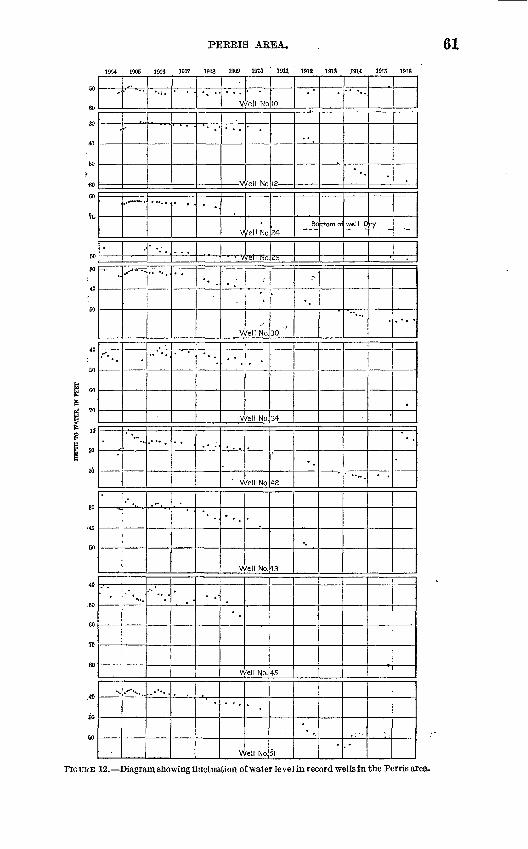
PERBIS AREA.
1904 ID05 IOCS 1907 1908 1909 1610 " 19U 1912 1913 J914 1915 1916
60
60
SO
40
60
? 60
60
7G.
' 60
30
40
60
40
CO
i CT5 g
1 »mg 2°o
30
30
40
60
40
.60
60
70
SO
.*>
50
eo
**
t-^»" .,
1aff
'
..
.
*.
. *"'%.
i.
.. .
.- -.
".
......
" '
,
. .
V
'
V
V
V
V
" V
v\
V,
' .
V
1'ell No
*
fell No
fell No
.'
','
^ /el! No.
/ell No
'ell No.
/ell No.
/ell No.
.
/ell No.
10
34
23
30 "
34
42
43
45
51
..
Bo
r
-.
-.
ttom o
"
well 0
"".
7
.
*
-
.
-
FIGURE 12. Diagram showing fluctuation of water level in record wells in the Perris area.
62 GROUND WATER IN SAN JACINTO AND TEMECULA BASINS, CAL.
In the wide sandy river channel above San Jacinto a part of the flood water has been successfully stored underground by spreading the water over the adjacent sandy wash lands and allowing it to be absorbed. During the spreading the surface is harrowed or plowed to break up the layer of silt deposited by the muddy water and permit the more rapid absorption of water, as the value of wat^r spreading, as practiced here and at a few other places in southern California, depends on the ability of the surface materials quickly to absorb the flood water. It has been thought locally that the ground-water supply near Perris might be replenished by allowing flood water from the river to flow into pits dug down to the beds of coarse sand and gravel that lie at depths ranging from 15 to 40 feet, but it seems very doubtful whether the muddy water could be prevented from silting up the sandy beds in such pits sufficiently to allow the absorption of enough water to justify the cost of the work. If the plan were carried out the ground-water level near the river might be appreciably raised, but the possibility of benefit to the lands north of Perris and in the vicinity of Ethanac, where the water level has lowered most seriously, is questionable.
IRRIGATION.
In the early nineties, in connection with the Bear Valley reservoir, which had recently been constructed, a pipe line and distribution system were laid through parts of Alessandro and Perris valleys, and a number of orchards were set out in the lands previously given over almost wholly to grain raising. The available water supply soon proved inadequate for the needs of all the lands originally watered by it, partly because of a succession of dry years that greatly reduced the quantity of water stored each winter, and partly because the growing trees required more water each year. As the lands in the Perris region were some of the latest to obtain water rights under the system, they were the first to suffer from the deficiency of water. Supply to these lands was discontinued about 1896, and after the failure of the Bear Valley supply there was little development in Perris Valley for several years. About the time that water ceased to be delivered through the pipe line to Perris lands, however, Dr. W. B. Pay ton proved the existence of a large supply of ground water by a well that he put down about 2 miles east of Perris. Others fol lowed his example, and by 1900 perhaps 500 inches (10 second-feet) of ground water was being developed in the Perris area. The Ethan A. Chase Co. of Riverside had purchased land 3 miles southwest of Perris in 1898. In 1899 the company bored a number of wells and the next year installed a pumping plant that delivered about 75 miner's inches. In 1900 the Temescal Water Co. likewise entered the valley^ sank wells, and constructed a canal through Railroad Canyon to Elsi- nore and thence down Temescal Wash to Corona to supply the orange
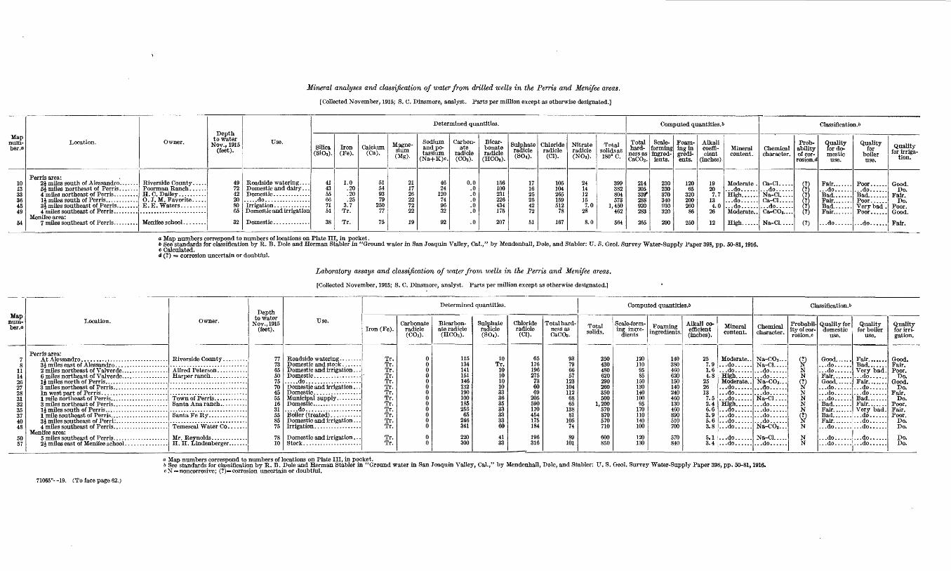
Mineral analyses and classification of water from drilled wells in the Penis and Menifee areas.
[Collected November, 1915; S. C. Dinsmore, analyst. Parts per million except as otherwise designated.]
Map num ber .«
10 13 33 36 45 49
54
Location.
Perris area: 24 miles south of Alessandro. ......5J miles northeast of Perris .......4 mUes northeast of Perris. ........
Menifee area:
Owner.
Riverside County ..... Poorman Ranch. .....H. C. Dailey..........
Depth to water
Nov., 1915 (feet).
49 72 42 20 80 65
32
Use.
Roadside watering. . . . Domestic and dairy . . . Domestic..................do................
Domestic and irrigation
Domestic .............
Determined quantities.
Silica (SlOi).
41 43 55 66 71 54
38
Iron(Fe).
1.0 .20.20 .25
3.7 Tr.
Tr.
Calcium (Ca).
51 54 93 79
250 77
75
Magne sium (Mg).
2117 26 22 72 22
19
Sodium and po tassium
(Na+K)c.
46 24
120 74 96 32
92
Carbon ate
radicle (COa).
0.0 .0 .0 .0 .0 .0
.0
Bicar bonate radicle
(HCOs).
156 100 231 226 434 175
207
Sulphate radicle (BOO.
17 16 25 25 42 72
51
Chloride radicle
(01).
105 104 265 159512
78
167
Nitrate radicle (N08).
24 14 12 15 7.0
28
8.0
Total solids at 180° C.
399 382 804 573
1,450 462
564
Computed quantities.!)
Total hard
ness as CaCO3 .
214 205 339* 288 920 283
265
Scale- forming ingred ients.
230 230 370 340 930 320
290
Foam ing in gredi- ents.
120 65
320 200 260
86
250
Alkali coeffi cient
(inches).
19 207.7
13 4.0
26
12
Mineral content.
Moderate . ...do...... High.........do...... ...do...... Moderate. .
High......
Classification.!*
Chemical character.
Ca-Cl........do...... Na-Cl.....Ca-Cl..... ...do...... Ca-COs....
Na-Cl.....
Prob ability of cor
rosion .d
: ' '
;
(
>'. ' . I 1 >'
0
Quality for do mestic
use.
...do......Bad.......Fair....... Bad....... Fair.......
...do......
Quality for
boiler use.
...do......Bad.......Poor...... Very bad . Poor......
...do......
Quality for irriga
tion.
Good. Do.
Fair. Do.
Poor. Good.
Fair.
<* Map numbers correspond to numbers of locations on Plate III, in pocket.6 See standards for classification by R. B. Dole and Herman Stabler in "Ground water in San Joaquin Valley, Cal.," by Mendenhall, Dole, and Stabler: U. S. Geol. Survey Water-Supply Paper 398, pp. 50-81,1916.c Calculated.d (?) = corrosion uncertain or doubtful.
Laboratory assays and classification of water from wells in the Perris and Menifee areas.
[Collected November, 1915; S. C. Dinsmore, analyst. Parts per million except as otherwise designated.]
Mapnum- ber.o
7 8
11 14 26 27 28 31 32 35 37 40 48
5057
Location.
Perris area:
Menifee area:
Owner.Depth
to water Nov., 1915
(feet).
77 73 65 50 75 70 45 55 16 31 55 85 75
78 10
Use.
Domestic and irrigation. . -
.....do....................Domestic and irrigation. . . Domestic. ................
.....do....................
Domestic and irrigation . . .
Domestic and irrigation . . .
Determined quantities.
Iron (Fe).
Tr. Tr. Tr. Tr. Tr. Tr. Tr. Tr. Tr. Tr. Tr. Tr. Tr.
Tr. Tr.
Carbonate radicle (CO,).
0 0 0 0 0 0 0 0 0 0 0 0 0
00
Bicarbon ate radicle (HC03 ).
115 134 141 151 146 132 190 100 185 258
65 246 341
220 300
Sulphate radicle (S0«).
10 Tr.
10 10 10 10 33 36 35 33 33 33 60
41 33
Chloride radicle
(Cl).
65 176 196 275
73 60 69
205 590 170 454 175 184
196 316
Total hard ness as CaCO3 .
93 79 66 57
123 104 112 68 65
138 81
105 74
89 101
Computed quantities.!)
Total solids.
250 430 480 620 290 260 350 500
1,200 570 870 570 710
600850
Scale-form ing ingre
dients
120 110 95 85
150 130 140 100 95
170 110 140 100
120 130
Foaming ingredients.
140 380 460 620 150 140 240 460 130 460 890 510 700
570 840
Alkali co efficient (inches).
25 7.9 1.6 4.8
25 26 13 7.5 2.4 6.6 3.9 5.6 3.8
5.1 3.4
Mineral content.
Moderate. . ...do...... ...do...... High...... Moderate.. ...do...... ...do.........do...... High...... ...do.........do.........do...... ...do......
...do......
...do......
Classification.!)
Chemical character.
Na-CO3 ... Na-Cl..... ...do...... ...do...... Na-C03... ...do...... ...do......Na-Cl.... ...do...... ...do.........do.........do...... Na-COs...
Na-Cl..... ...do......
Probabil ity of cor- rosion.c
S?N N
9N N N N<8N
N N
Quality for domestic
use.
...do......
...do...... Fair.......
...do......
...do......
...do......Bad.......Fair.......Bad.......Fair..........do......
...do......
...do......
Quality for boiler
use.
Bad....... Very bad. ...do...... Fair..........do.........do...... Bad.......
Very bad. ...do.........do.........do......
...do......
...do......
Quality for irri gation.
Good. Fair. Poor.
Do. Good.
Do. Fair.
Do. Poor. Fair. Poor.
Do. Do.
Do. Do.
a Map numbers correspond to numbers of locations on Plate III, in pocket.b See standards for classification by R. B. Dole and Herman Stabler in "Ground water in San Joaquin Valley, Cal.cN=noncorrosive; (?)= corrosion uncertain or doubtful.
by Mendenhall, Dole, and Stabler: U. S. Geol. Survey Water-Supply Paper 398, pp. 50-81,1916.
71065°- -19. CTo face page 62.)

PERRIS ABE A. 63
groves of that section. A failure of local supplies in an earlier period had forced Corona orchardists to use the Elsinore Lake water, but this water was so alkaline that its use seriously injured the trees, and the orange growers -were forced to seek supplies elsewhere.1 This necessity led them to Perris Valley and to the construction of a pipe line thence to Corona. The pipe line has a capacity of about 600 inches and the pumping of this amount of water for conveyance outside the valley, together with the growing local developments and the dry years, led to lowering of the water table and to litigation over water rights. The right of the Temescal Water Co. to its supply was confirmed, and it now pumps during the irrigating months up to the capacity* of its pipe line. Local developments have likewise continued and, during recent years, at an increasing rate. In 1899 there were six plants in Perris Valley, pumping a total of about 500 miner's inches of water. In 1907 there were thirteen plants in addition .to those of the Temescal Water Co., the total capacity of all being about 2,000 inches. In the fall of 1915 sixty-one active plants were counted, including those of the Temescal Water Co. A number of dismantled plants also were scattered through the valley. The total area irrigated was about 4,000 acres, nearly all being planted to alfalfa, and other fields were being leveled pre paratory to seeding. (See PI. XI, B.) Assuming a duty of water of 3 acre-feet to the acre, apparently about 12,000 acre-feet of water was lifted during the irrigating season to supply the local needs, in addition to the 600 or 700 acre-feet pumped during the season of eight or ten months from the wells of the Temescal Water Co.
QUALITY OF WATER.
Samples of water collected from 19 wells scattered throughout the Perris area were examined chemically to ascertain their value for irrigation and other uses. The results of the analyses and labora tory assays are given in the tables facing page 62,
The analyses of water from wells in the Perris area show a con siderable range in the amount of the dissolved constituents. The lowest amount of dissolved mineral matter 250 parts per million is found in the water from well No. 7 at Alessandro. The greatest amount of mineral matter 1,450 parts per million is found in well No. 45, 3\ miles southeast of Perris. The waters range from good to bad for domestic use and from good to poor for irrigation. A few of the waters have been classed as fair for boiler use, but most of them are bad or very bad because of large amounts of scale-forming or foaming ingredients.
i The increase in alkalinity of the orchard soils is described by E. W. Hilgard in U. S. Dept. Agr. Report of irrigation investigations, 1901, p. 144,1902.
64 GROUND WATER IN SAN JACINTO AND TEMECULA BASINS, GAL.
ALKALI.
The lower parts of Perris Valley, epecially the lands east of Perris near the river channel, are flat and poorly drained. Alkali has here formed to some extent, but presumably during a period prior to the development of irrigation, when the ground-water level was close to the surface and evaporation and concentration took place from a fairly moist area. In recent years the depth to water has increased, and in 1915 it was 30 feet or more throughout the alkaline areas. This lowering of the ground-water level has probably benefited the lowlands by stopping the accumulation of alkali, but the lands are so flat that it might prove difficult to leach out the salts by irrigation and drainage. Common salt seems to be the principal salt in the waters, and although apparently not present in very great amount, it prevents satisfactory growth of grain on the land. It is possible, however, that some forage crops more resistant to alkali could be profitably grown on some of the land that was uncultivated in 1915.
MENTFEE AREA.
LOCATION AND CHARACTER.
The Menifee area as here described includes Menifee and Paloma valleys. On the north it is separated from Perris Valley by a wide, low alluvial divide. On the east it receives the drainage from Win chester and Domenigoni valleys through narrow connecting belts of lowland. Its eastern extension, Paloma Valley, is a wide area of gently rolling land that rises southward in its central part to an ill- defined divide that marks the limit of the San Jacinto basin in this locality. The drainage outlet from Menifee Valley is westward through Salt Creek to San Jacinto River in Railroad Canyon. In the western part of the valley the creek channel is well denned, but the run-off from the tributary valleys to the east and south is small and it has succeeded in forming only slight channels through the greater part of Menifee Valley.
In its lower course Salt Creek reaches Railroad Canyon through a deep gorge that is locally considered to be a former channel of the main river a hypothesis that is favored by the disproportionate size of the gorge with respect to the flood water that now passes through it. A well drilled in 1915 at the outlet of the valley struck water- worn gravel containing pebbles the size of a man's fist at a depth of 90 to 121 feet, and another well 245 feet deep, encountered similar gravel but no bedrock. The presence of the deeply buried gravel tends to confirm the topographic evidence that Salt Creek may have been at one time the outlet of San Jacinto River, but neither the available logs of wells nor the present surface features indicate whether the river flowed through Menifee Valley by way of Perris Valley or entered it from Winchester Valley.
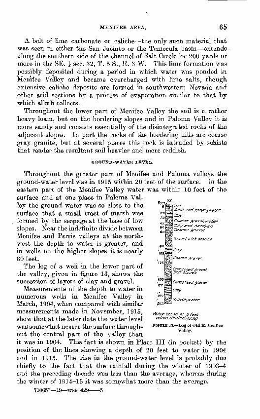
MENIFEE AEEA. 65
Feet
A belt of lime carbonate or caliche the only sucn material that was seen in either the San Jacinto or the Temecula basin extends along the southern side of the channel of Salt Creek for 200 yards or more in the SE. J sec. 32, T. 5 S., R. 3 W. This lime formation was possibly deposited during a period in which water was ponded in Menifee Valley and became overcharged with lime salts, though extensive caliche deposits are formed in southwestern Nevada and other arid sections by a process of evaporation similar to that by which alkali collects.
Throughout the lower part of Menifee Valley the soil is a rather heavy loam, but on the bordering slopes and in Paloma Valley it is more sandy and consists essentially of the disintegrated rocks of the adjacent slopes. In part the rocks of the bordering hills are coarse gray granite, but at several places this rock is intruded by schists that render the resultant soil heavier and more reddish.
GROUND-WATER LEVEL.
Throughout the greater part of Menifee and Paloma valleys the ground-water level was in 1915 within 20 feet of the surface. In the eastern part of the Menifee Valley water was within 10 feet of the surface and at one place in Paloma Val ley the ground water was so close to the surface that a small tract of marsh was formed by the seepage at the base of low slopes. Near the indefinite divide between Menifee and Perris valleys at the north west the depth to water is greater, and in wells on the higher slopes it is nearly 80 feet.
The log of a well in the lower part of the valley, given in figure 13, shows the succession of layers of clay and gravel.
Measurements of the depth to water in numerous wells in Menifee Valley in March, 1904, when compared with similar measurements made in November, 1915, show that at the later date the water level was somewhat nearer the surface through out the central part of the valley than it was in 1904. This fact is shown in Plate III (in pocket) by the position of the lines showing a depth of 20 feet to water in 1904 and in 1915. The rise in the ground-water level is probably due chiefly to the fact that the rainfall during the winter of 1903-4 and the preceding decade was less than the average, whereas during the winter of 1914-15 it was somewhat more than the average.
71065° 19 WSP 429 5
Sane/ and'grave/j
Clay
Coarse grave/; wCfay ana? ftCoarse grave/
Grave/ with stones
Clay
Coarse gravel
Cemented grave} 3na stones
Cemented grave/
C/ay
Water stood at 6 feet When c/ri//ed(/898J
FIGURE 13. Log of well in Menife« Valley.
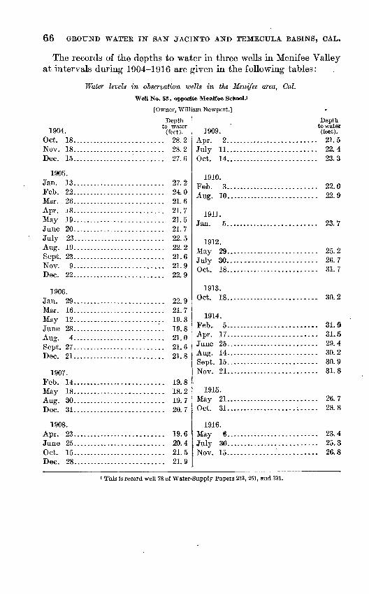
66 GBOUND WATER IN SAN JACINTO AND TEMECULA BASINS, OAL.
The records of the depths to water in three wells in Menifee Valley at intervals during 1904-1916 are given in the following tables:
Water levels in observation wells in the Menifee area, Cal.
Well No. 53, opposite Menifee SchooU
[Owner, William Newport.]
1904. Get. 18.............Nov. 18.............Dec. 15.............
1905. Jan. 13.............Feb. 22.............Mar. 26.............Apr. 18.............May 19.............June 20.............July 23.............Aug. 19.............Sept. 23.............Nov. 9....-...-.-..Dec. 22.............
1906. Jan. 29.............Mar. 16-.......---..May 12.............June 28............._A nor 4
Sept. 27. ............
1907. Feb 14May 18.............Aug. 30.............Tior> 11
1908. Apr. 23.............
Oct. 15.. .......... .Dee. 28...-.-.-.....
Depth to water
(feet)............. 28.2............ 28. 2............ 27. 6
............ 27. 2............. 24. 0............. 21. 6............. 21.7............ 21.5............ 21.7............. 22. 5............. 22.2............. 21.6............. 21. 9............ 22. 9
............ 22. 9............. 21. 7............. 19. 8-.._.__..... JLt7. O
............. 21. 0............ 21. 6
91 O
............ 19.8............. 18.2
ig 7Of) 7
............. 19. 6
............. 20.4
............. 21.5
............. 21.9
]909. Apr. 2..............July 11..............Oct. 14..............
1910. Feb. 3..............Aug. 10.............
19-11.
1912.May 29.............July 30............. Oct. 18..............
1913. Oct. 18..............
1914. Feb, 5..............Apr. 17.............
Aug. 14... ...........Sept. 15..............Nov. 21..............
1915. May 21..............Oct. 31..............
1916. May 6..............July 30..............Nov. 15.. ...........
Depth to water (feet).
............ 21. 5
............ 22. 4
............ 23. 3
99 n99 Q
............ 23. 7
OK O
Ql 7
............ 30. 2
............ 31.9
............ 31.5
............ 29. 4
............ 30. 2
............ 30. 9
............ 31. 8
............ 26,7
............ 28. 8
............ 23. 4
............ 25.3:........... 26. 8
' This is record well 78 of Water-Supply Papers 213, 251, and 331.
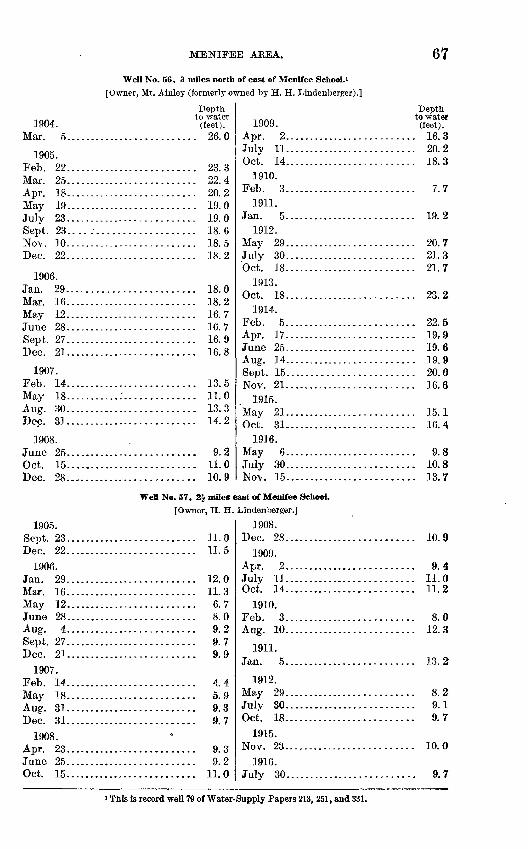
MENIFEE AREA.
Well No. 56, 3 miles north of east of Menifee School.![Owner, Mr. Ainley (formerly owned by H. H. Lindenberger).]
67
1904.
1905. Feb. 22......Mar. 25......
A TV-» 1 Q
May 19......July 23......Sept. 23.. .. .Nov. 10......Dec. 22......
1906. Jan. 29......Mar. 16......May 12......June 28Sept. 27T) pr. OT
1907.Feb. 14......May 18......Aug. 30......Dec. 31......
1908.
Oct. 15......Dec. 28......
1905. Sept. 23......Dec. 22......
1906. Jan. 29......A/Tor 1 fi
May 12......June 28......A no* 4Sept. 27......Dec. 21......
1907. Feb. 14......May 18......A lin. O"1
Dec. 31......1908.
A TVT 9Q
June 25......Oct. 15......
Depth to water
(feet)..................... 26.0
.................... 23.3
.................... 22. 4?n 9
.................... 19.0IQ n
................... 18.6
.................... 18.5
.................... 18.2
................... 18. 0
.................... 18.2
.................... 16.71/1 hr
16 Q1 A 9
.................... 13.5
.....:.............. 11.0
.................... 13.3
.................... 14.2
.................... 9.2
.................... 11.0
.................... 10.9
Wett No. 57, 2J miles c[Owner, H. H.
.................... li.O
.................... 11.5
.................... 12.0n o
.................... 6.7
.................... 8.0
.................... 9.2Q 7
.................... 9.9
.................... 4.45 Q
9 0
9 7
9 c>
.................... 9.2..... 11.0
1909. Apr. 2..................July 11..................Oct. 14..................
1910. Feb. 3..................
1911. Jan. 5..................
1912. May 29..................July 30..................Oct. 18..................
1913. Oct. 18..................
1914. Feb. 5..................Apr. 17..................June 25 ..................
Sept. 15.................Nov. 21..................
1915.Ma \T 91
Oct. 31..................1936.
May 6..................July 30..................Nov. ]5.. ................
sast of Menifee School.Lindenberger.]
1908. Dec. 28..................
1909. Apr. 2..................July 11..................Oct. 14..................
1910. Feb. 3..................Aug. 10..................
1911. Jan. 5..................
1912. May 29..................July 30..................Oct. 18..................
1915. Nov. 23..................
1916. Jiilv 30. ......
Depthto water (feet).
........ 16. 3
........ 20. 2
........ 18.3
........ 7.7
........ 19. 2
........ 20. 7
........ 21.3
........ 21. 7
........ 23. 2
........ 22. 5
........ 19, 9
........ 19.6TO Q
........ 20. 0
........ 16. 6
........ 15.1
........ 16. 4
........ 9. 8
........ 10. 8
........ 13. 7
........ 10. 9
........ 9. 4
........ 11.0
........ 11.2
........ 8. 0
........ 12. 3
........ 13. 2
........ 8.2
........ 9. 1
........ 9. 7
........ 10. 0
........ 9. 7
i Tnis is record well 79 of Water-Supply Papers 213, 251, and 331.
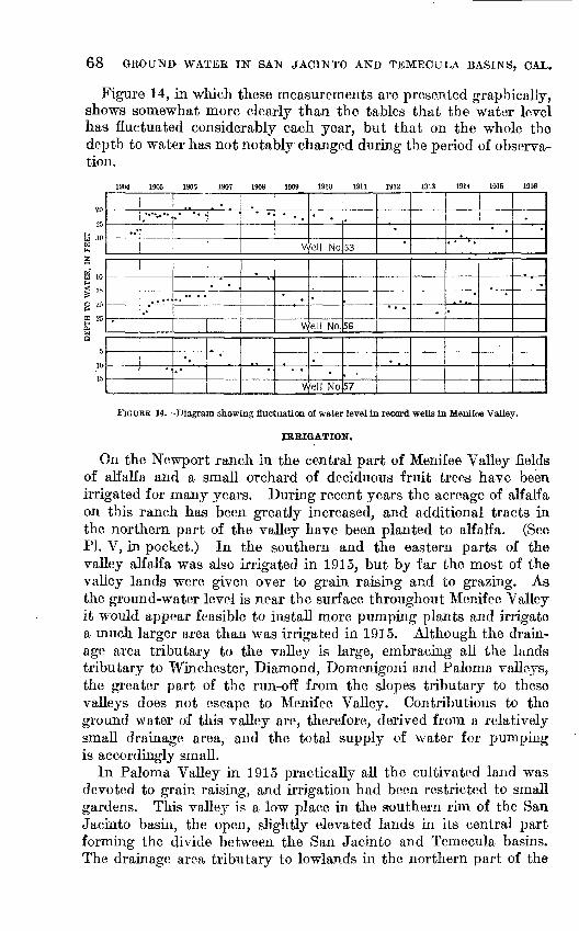
68 GROUND WATER IN SAN JACINTO AND TEMECULA BASINS, CAL.
Figure 14, in which these measurements are presented graphically, shows somewhat more clearly than the tables that the water level has fluctuated considerably each year, but that on the whole the depth to water has not notably changed during the period of observa tion.
1907 1909 1914
Well No.53
Vyell No. 56
Well No.57
FIGURE 14. Diagram showing fluctuation of water level in record wells in Menifee Valley.
IRRIGATION.
On the Newport ranch in the central part of Menifee Valley fields of alfalfa and a small orchard of deciduous fruit trees have been irrigated for many years. During recent years the acreage of alfalfa on this ranch has been greatly increased, and additional tracts in the northern part of the valley have been planted to alfalfa. (See PL V, in pocket.) In the southern and the eastern parts of the valley alfalfa was also irrigated in 1915, but by far the most of the valley lands were given over to grain raising and to grazing. As the ground-water level is near the surface throughout Menifee Valley it would appear feasible to install more pumping plants and irrigate a much larger area than was irrigated in 1915. Although the drain age area tributary to the valley is large, embracing all the lands tributary to Winchester, Diamond, Domenigoni and Paloma valleys, the greater part of the run-off from the slopes tributary to these valleys does not escape to Menifee Valley. Contributions to the ground water of this valley are, therefore, derived from a relatively small drainage area, and the total supply of water for pumping is accordingly small.
In Paloma Valley in 1915 practically all the cultivated land was devoted to grain raising, and irrigation had been restricted to small gardens. This valley is a low place in the southern rim of the San Jacinto basin, the open, slightly elevated lands in its central part forming the divide between the San Jacinto and Temecula basins. The drainage area tributary to lowlands in the northern part of the
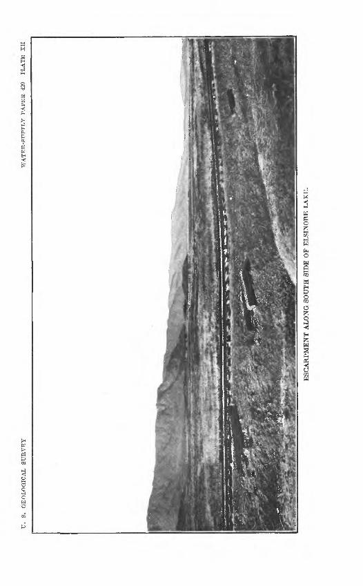
TJ.
S
. G
EO
LO
GIC
AL
S
UR
VE
YA
VA
TE
R-S
TJP
PL
Y
PA
PE
R
429
PL
AT
E
XII
ESC
AR
PM
EN
T A
LO
NG
SO
UT
H S
IDE
OF
EL
SIN
OR
E L
AK
E.

ELSIFORE LAKE AREA. 69
valley is therefore small, and the supply of ground water available for irrigation is also doubtless very small. -It is probable, however, that in the lower lands in the northern part of the valley sufficient water can be obtained from wells to irrigate on the adjacent slopes a con siderable acreage of deciduous fruit trees, which require much less water per acre than is required by alfalfa.
QUALITY OF WATER.
The results of chemical examination of samples of water from three wells in Menifee Valley (Nos. 50, 54, and 57) are included in the table opposite page 62.
The analyses show that well 50 furnishes a sodium-chloride water containing 600 parts per million of total solids, nearly one-third of which is chloride. In 1915 the water was used both for domestic supply and for irrigation, but it is poor for irrigation and only fair for domestic use. Well 54, at Menifee school, furnishes sodium- chloride water which is fair for domestic use. Well 57, which was in 1915, used only to supply a cattle trough, yields water containing 316 parts of chloride. It is a sodium-chloride water, of poor quality for irrigation.
ALKALI.
As would be expected in a valley where the ground-water level is relatively close to the surface and the water is of the character indi cated by the three analyses given, alkali has collected in noticeable amounts in parts of Menifee Valley, the more alkaline land forming a belt along the course of Salt Creek. In the eastern part of the valley certain areas near the channel of the creek are apparently too alkaline to permit the raising of grain but the appearance of the land in 1915 did not indicate that it was too alkaline for the successful growing of sugar beets or other alkali-resistant forage crops.
ELSINORE LAKE AREA.
LOCATION AND CHARACTER.
Elsinore Lake lies southwest of the main San Jacinto basin, whose run-off it receives through Railroad Canyon. The lake basin is bordered on the southwest by the steep and imposing front of Elsinore Mountains (see PL XII) and on the northeast by hills which, though much less prominent, rise abruptly near the lake edge. At the northwest end the slope upward to the mountains is fairly steep, but to the southeast a wide area of lowland succeeded by a gently rolling surface extends to the indefinite divide between the Elsinore and Temecula basins.
70 GROUND WATER IN SAN JACINTO AND TEMECULA BASINS, CAL.
GEOLOGIC FEATURES.
Elsinore Lake basin was probably in large part formed by a fault along which the San Jaeinto mountain mass, as related to the Santa. Ana and Elsinore mountain masses, was dropped. The prominent fronts of the latter ranges furnish suggestive evidence of the fault zone, and the hot water that rises at Elsinore further indicates that the fault passes along the northeast side of Elsinore Valley. Soft Tertiary rocks in the basin, as at Alberhill and at points down the valley of Temescal Wash toward Corona, furnish additional evidence of faulting, and probably, through their lack of resistance to erosional processes as compared with the harder rocks on each side, have been instrumental in determining the position and form of the basin.
The mountains on the western side of the lake basin and most of the hills on its eastern side are composed of ancient granitic and schistose rocks. To the north is an area of hills composed of elays and coarser sediments that are of Tertiary age. (See PL III, in pocket.) Thin beds of lignitio coal in this series were at one time worked near Alberhill, and the clay beds near Terra Cotta have been worked intermittently for pottery for many years. In 1915 a test well for oil was put down in the hills a mile east of Lucerne. The following approximate record of the material penetrated by this well was kindly furnished by Mr. Charles Hudson, of Elsinore.
Log of oil test well east of Lucerne, Cal.
Thickness.
Feet. 60
140
5008
522
15
Depth.
Feet.
200
850858910912Q97
In the southeastern part of the lake basin (shown in PL XIII, B) the higher valley lands and the low, rolling hills along the southwestern side are covered by coarse gravels and gravel mixed with clay. These sedimentary materials resemble some of the coarser deposits near Alberhill, but no workable clay deposits have been found hi the southern part of the basin. The deposits to the north and to the south of the lake were probably formed at different periods. Fossil plants collected from the Alberhill beds by Dr. Stephen Bowers have been identified by F. H. Knowlton to be of Eocene age, and they are probably contemporaneous with part of the beds of the Badlands north and east of Moreno; whereas the gravels in the southern end of Elsinore Lake basin are probably of Quaternary age and contem poraneous with the gravels east and southeast of San Jaeinto.
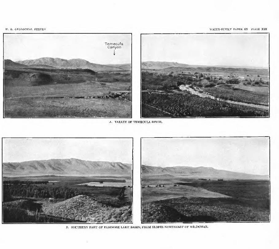
U. 8. GEOLOGICAL SURVEY WATER-SUPPLY PAPER 429 PLATE XIII
Ternecu I a Canyon
A. VALLEY OF TEMECULA RIVER.
B. SOUTHERN PART OF ELSINORE LAKE BASIN; FROM SLOPES NORTHEAST OF WILDOMAR.

ELSIFOEE LAKE AEEA. 71
From tlie hills of crystalline rocks that border most of the lake basin bench lands of reddish compact clay and gravel extend down to the lowlands, which are in most places covered by the more recent gravels and alluvial material of the present-day stream channels.
SURFACE WATEB.
Elsinore Lake is a brackish water body 4 or 5 miles long and 2 miles wide, at the east base of Elsinore Mountains. During normal stages it has no outflow and fluctuates only 4 or 5 feet in height during the year; but a few times since the settlement of the region it has over flowed through a channel on its eastern side through the city of ELsinore and down Temescai Wash to Santa Ana Elver.
The following history of Elsinore Lake is abstracted from an account written hi 1916, by Francis R. Schanck,. assistant inspector of irrigation, United States Indian Service, Los Angeles, Cal.:
The earliest specific reference to the amount of water in. Lake ETsinore is apparently contained in the notea of a traveler who jpassed through southern California about 1810 and who mentions " Laguna Grande " the original Mexican name for the lake as being little more than a swamp about a mile long. Between that time and 1862 information concerning its rise and lall is meager, but in that year it was very high and probably overflowed. During the succeeding dry period^ especially during the years 1866 and 1867, when practically no rain fell on the drainage area tributary to the lake, it receded very rapidly, but in 1872 it was again full, and overflowed down its outlet through Temescai Canyon. After this date evaporation reduced it to a level probably as low as it has ever been since, but the great rains of the winter of 1883-84 filled it to overflowing in three weeks, Americans who* had by this time settled around it say that the low-water shore line was surrounded by willow trees so large that they must have been at least 30 years- old. In the next 10" years rainfall was excessive and the lake stayed high, overflowing naturally during three or four years of this decade, and having been purchased by the Temescai Water Co. for the irrigation of lands at Corona, Cal., its outlet channel was deepened, permitting gravity flow to Corona for a year or more after the lake level had sunk below the grade of its outlet. As the surface still receded a pumping plant was installed and water was raised a maximum of about 10 feet, then flowing down the natural channel of Temescai Canyon. Pumping was continued a couple of seasons, but the concentration of salts in the lake, due to the evaporation and to low rainfall sooa unfitted the water for irrigation. After 1893 the water level sunk almost continuously for nearly 10 years, rising,, of course, slightly every winter. The yeara of heavier precipitation beginning in 1903 gradually filled the lake about half the depth between its minimum level since 1883 and its high level or overflow point, which was again reached in 1916.
The fact that large trees were growing at an elevation of 20 feet or more below the high-water level when the lake filled in 1883-84, indicates that the high water of the sixties and seventies must have been of very short duration. The stumps of the trees were still visible in 1888 and 1889 many hundred feet from shore, but by the time the lake receded in the middle nineties these trunks had disappeared.
The rise that took place in the spring of 1916 was the greatest within recent years, although the run-off from its drainage area into the lake appears to have been considerably less than that of the wet years of 1883-84 and 18-88-89. Owing to the unusually heavy rains of January and February, 1916, the lake rose rapidly, submerged extensive lowlands to the south and southeast, and overflowed down Temescai Wash. The daily record of the height of the lake surface,
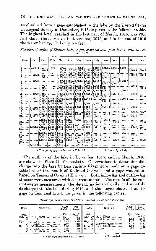
72 GROUND WATER IN SAN JACINTO AND TEMECULA BASINS, CAL.
as obtained from a gage established in the lake by the United States Geological Survey in December, 1915, is given in the following table. The highest level, reached in the last part of March, 1916, was 20.4 feet above the lake level in December, 1915, and to the end of 1916 the water had receded .only 5.4 feet.
Elevation of surf ace of Elsinore Lake, in feet, above sea level, from Dec. 1, 1915, to Dec.31, 1916.
Day.
1...... 2...... 3...... 4...... 5...... 6......7...... 8...... 9......
10...... 11......12...... 13...... 14...... 15......16...... 17...... 18...... 19...... 20......21...... 22......23......24.....25......26...... 27......28...... 29...... 30......31......
Dec.
1,245.2
i,"245."2
1, 245. 2
1,245.2
i,~245.~2
i,'245."2
1,245.2
1, 254. 2
......
1, 245. 3
Jan.
i,"245."4
i,"245."4
i"245."4 1, 245. 41,245.41, 245. 4 1, 245. 4 1. 245. 4 1, 245. 4 1, 245. 41, 245. 4 1, 246. 7 1, 247. 2 1, 248. 2 1,250.21, 251. 2 1, 252. 2 1, 252. 7 1, 252. 9 1,253.21,254.0 61,254.5 61,255.5 1, 257. 5
.......
Feb.
(a)
.......
.......
i,"263."4 1, 263. 5 1,263.61, 263. 7 1, 263. 8 1, 263. 8 1,263.9 1,264.01, 264. 0 1. 264. 2 1, 264. 2 1, 264. 3 1,264.31 264 4l' 264. 31, 264. 3 1,264.4
......
Mar.
1,264.5 1,264.6 1, 264. 6 1, 264. 7 1,264,81,264.9 1,265.0 1, 265. 1 1,265.2 1,265.21, 265. 3 1,265.3 1, 265. 3 1, 265. 3 1,265.31,265.3 1, 265. 3 1,265.3 1,265.3 1,265.61,265.6 1,265.6 1,265.6 1,265.6 1,265.61.265.6 1, 265. 6 1,265.6 1, 265. 6 1,265.61, 265. 6
Apr.
1, 265. 6 1,265.6 1, 265. 5 1,265.51,265.5 1, 265. 4 1, 265. 3 1, 265. 3 1,265.31, 265. 3
i,"265."3
i,"265."21,265.2 1,265.1 1,205.1 1, 265. 1 1,265.01,265.0 1, 265. 0 1, 264. 8 1, 264. 7 1,264.7
i"264."6 1, 264. 7 1, 264. 6
.......
May.
1,264.51,264.5 1, 264. 5 1, 264. 4 1,264.41,264.3
i"264."2 1, 264. 2 1, 264. 21, 264. 1 1, 264. 1 1,264.1 1, 264. 0
1,263.9
i,"263."8
1, 263. 8
i,"263.'6
i,"263."6
i"263."6 1, 263. 5
i" 2(53." 51,203.4
June.
1,263.4 1,264.4 1,263.3 1,263.31,263.3 1,263.2 1,263.2 1, 263. 2 1,263.21,263.2
i,~263."i
iJ263."61, 263. 0 1, 262. 9 1,262.9 1,262.<> 1,262.9
i"262.~8 1,262.8 1, 262. 8
1. 262. 7 i; 262. 7 1, 262. 7 1,262.6 1, 262. 6
July.
1,262.61, 262. 5 1,262.5 , 1262. 5 1,262.51,262.4
1*262." 4 1, 262. 4 1,262.41,262.3 1, 262. 0
i,"262."6
i,"262."6
i~262."6 i"26i."9
1,261.8
1, 261. 8
i,"26L8
.......
Aug.
1,261.7
i~26i."6
iJ26L6
1, 261. 6
iJ26i.~5 1,261.5
i"26i."4 i~26i."4
1, 261. 4
i,"26i."3
1,261.3
i,"26i."3i"26i."3
1, 261. 2
Sept.
1,261.2
iJ26i."6
1,261.0
1,261.0
ijms
1, 260. 8
i,"260.~8
1,260.8
i,"266.~6
.......
Oct.
1,260.6
1,260.6
I'm 6
i,"260."7
i,'260."c
i,"266.~4 1, 260. 4
1, 260. 4
.......
Nov.
1,260.4
i,"260."4
i,"266."4
1, 260. 2
1, 260. 2
1, 260. 2
i,"260."2
1, 260. 0
1, 260. 0
.......
Dec.
1,260.0
i,"260."6
i'm'o
i,"26a"6
i,"260.~6
1,260.0
ijm'o
i,"260.'6
i,"260."2
.......a Temporary gage under water Feb. 1-12. 6 Probably windy.
The outlines of the lake in December, 1915, and in March, 1916, are shown in Plate III (in pocket). Observations to-determine dis charge into the lake by San Jacinto River were made on a gage es tablished at the mouth of Railroad Canyon, and a gage was estab lished on Temescal Creek at Elsinore. Both inflowing and outflowing streams were measured with a current meter. The results of; the cur rent-meter measurements, the determinations of daily and monthly discharge into the lake during 1916, and the stages observed at the gage on Temescal Creek are given in the following tables:
Discharge measurements of San Jacinto River near Elsinore.
Date.
1916. Jan. 25
26Feb. 13
24Mar. 9
10 21
Made by
F.C.Ebert. ................do......................do......................do.................
.....do.................
Gage height.
Feet. 10.4in ^93.402.973 0A
3.20 2.74
Dis charge.
Sec. ft. 680651
a376236OJQ
324 180
Date.
1916. Apr. 10
28May 6
26
July 9
Made by
F.C.Ebert.................do......................do.................McGlashan and Ebert . .F.C.Ebert.................do.................
Gage height.
Feet. 2.371.831.421.381.06.96
Dis charge.
Sec. ft. 115. 0032.009.305.406.30t.05
a New gage installed Feb. 13,1916. b Estimated.
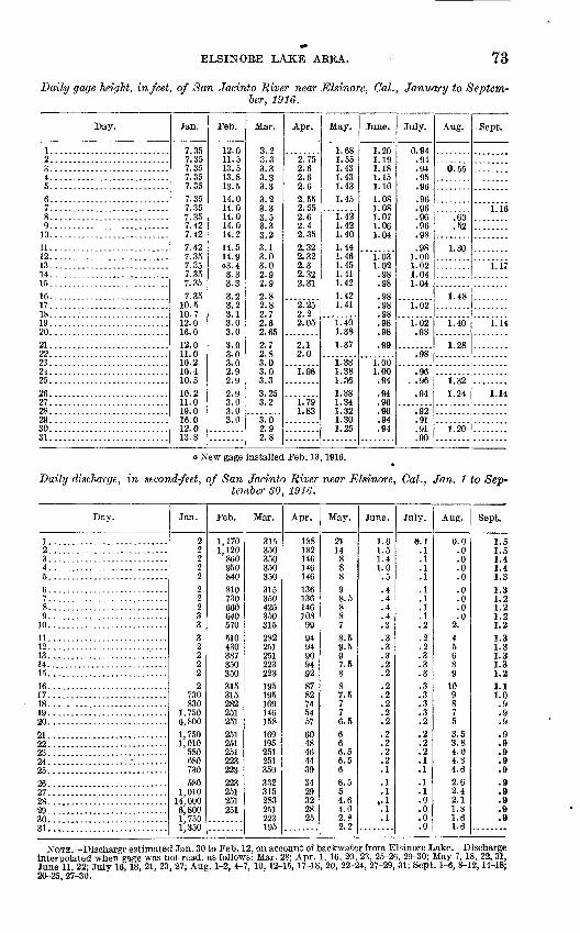
ELSINORE LAKE AREA. 73
Daily gage height, infect, of San Jadnto River near Elsinore, Cal., January to Septem ber, 1916.
Day.
1. ..........................2.......... ..... . ...3...........................4...........................5...........................6...........................7...........................8...........................9...........................10...........................11...........................12...........................13...........................14...........................15...........................16...........................17...........................18......:....................19...........................20...........................21 ...........................22...........................23 ...........................24 ...........................25...........................26...........................27...........................28...........................29...........................30...........................31 ...........................
Jan.
7.357.357.357.357.357.357.357.357.427.427.427.357.357.357.357.35
10.510.712.016.012.011.010.210.410.510.211.019.016.012.013.8
Feb.
12.011.513.513.813.514.014.014.014.014.214.514.9
3.33.3
3.23.23.13.03.03.03.03.02.99 Q
9 Q3.03.03.0
Mar.
3..23.33.33.33.33.23.33.53.33.23.13.03.02.92.92.82.82.72.62.652.72.83.03.03.33.253.2
3.02.92.8
Apr.
2.752.62.62.6
2.552.552.62.42.352.322.322.32.322.31
2.252.22.05
2.12.0
1.96
1.791.83
May.
1.681.551.431.431.431.45
1.421.421.401.441.461.451.411.421.421.41
1.401.381.37
1.381.381.361.381.341.321.301.25
June.
1.201.191.181.151.101.081.081.071.061.04
1.031.02.98.98.98.98.980808
.99
1.001.00.94.94.96.96.94.94
July.
0.94.94.94.95.96.96.96.96.96.98.98
1.001.021.041.04
1.02
1.02.98
OS
.96Qfi
.94
.92
.91Q1
.90
Aug.
6.55
60.52
1.30
1.48
1.40
1.28
1 09
1 24
1.20........
Sept.
1.16
1.17
1.14
1.14
a New gage installed Feb. 13,1916.
Daily discharge, in second-feet, of San Jacinto River near Elsinore, Cal., Jan. 1 to Sep tember SO, 1916.
Day.
1. ..........................2...........................3...........................4...........................5...........................6...........................7...........................8...........................9...........................10...........................11...........................12...........................13...........................14...........................15...........................16...........................17...........................18...........................19...........................20...........................01
22...........................23...........................24 ............................25...........................26...........................27...........................28...........................29...........................30...........................31 ...........................
Jan.
2222222233322222
730830
1,7506,8001,7501,010580680730580
1,01014,0006,8001,7501,350
Feb.
1,1701,120
860950840810730660640570510430387350350315315282251251251251251223223223251251251
Mar.
3153503503503503153504253503152822519VI223223195195169146158169195251251350332315283251223195
Apr.
188182146146146136136146108999494909492878274545760484644393429322825
May.
211488898.58878.59.5Q
7.5887.5776.5
666.56.566.554.64.02.82.2
June.
1.61.51.41.0.5
.4
.4
.3
.3
.3
.3
.2
.2
.2
.2
.2
.2
.2
.2
.2
.2
.2
.1
.1
.1« !.1.1
July.
e. i.1.1.1.1.1.1.1.2.2.2.3.3.3.3.3.3.3.2.2.2.2.1.1.1.1.0.0.0.0
Aug.
0.0.0.0.0.0.0.0.0.0
2.456891098753.53.84.04.34.62.62.42.11.81-61.6
Sept.
1.51.51.41.41.3i i1.21.21 91.21.31.3i ^1.31.21.11.0.9.9.9.9.9.9.9.9.9.9.9.9.9
NOTE Discharge estimated Jan. 30 to Feb. 12, on account of backwater from Elsinore Lake. Discharge interpolated when gage was not read, as follows: Mar. 28; Apr. 1, 16, 20, 23, 25-26, 29-30; May 7, 18, 22,31, June 11, 22; July 16,18, 21, 23, 27; Aug. 1-2, 4-7, 10, 12-15, 17-18, 20, 22-24, 27-29, 31; Sept. 1-6, 8-12,14-18; 20--25, 27-30.
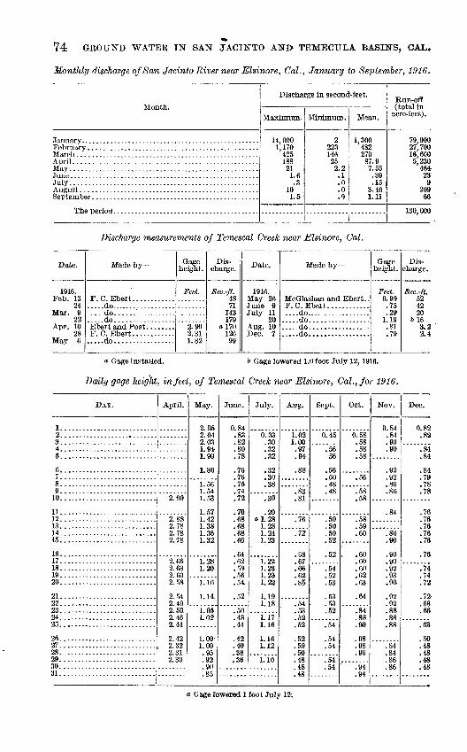
74 GEOUND WATEE IN SAN JACINTO AND> TEMECULA BASINS, OAL.
MonOily discharge of San Jacinto River near Elsinore, CaL, January to September, 19-16.
Month.
July .....................................................
Discharge in second-feet.
Maximum.
14,000 1,170
425 188 21 1.6 .3
10 1.5
Minimum.
2 223 146 25 2.2 .1 .0 .0 .9
Mean.
1.300 482 270 87.9 7.55 .39 .15
3.40 1.11
Run-off (total in
acre-feet).
79.900 27,700 16,600 5,230
464- 23
9 209
66
130,000
Discharge measurements of Temescal Creek near Elsinore, CaL
Date.
1916. Feb. 13
24Mar. 9
22
28May 6
Made by
F.C.Ebert.. ...............do......................do......'................do.................
F.C.Ebert.................do.................
Gage height.
Feet.
2.902.311.82
Dis charge.
Sec.-ft. 4871
143179
a 17012699
Date.
1916.
July 1120
Made by
....do.......................do......................do......................do.................
Gage height.
Feet. 0.99.75.29
1.19.81.79
Dis charge.
Sec.-ft. 524220
6163.22.4
a Gage installed. 6 Gage lowered 1.0 foot July 12, 1916.
Daily gage height, in feet, of Temescal Creek near Elsinore, CaL, for 1916.
DAY.
I................ ........
S. ..........................4. ..........................5...........................
6...........................7...........................8...........................9...........................10...........................
11...........................12...........................13...........................14...........................15...........................
16...........................17...........................18...........................19...........................20...........................
21...........................22............................23...........................24...........................25..........................
2«. ..........................2r.. .........................28. ..........................2^. ..........................30...........................31...........................
April.
2.90
2.88
2.782.78
2.669 fi°i
2.58
2.49
2.462.44
2.42
2.31
May.
2.052.04
1.941.90
1.86
1 P»fi
1.53
1 571.421.38
1.32.
1.281 1ft
1.16
1.14
i.051.02.
1.001.00.95
QO
.90OK
June.
0.84QO
.82
.80
.78
.76
.7671
.74
.72
.70
.68
.68
.68
.66
.64
.62KQ
^.ft
K.A
K.9
.50
.48
.44
.42
.40
.38Oft
July.
0 00
on
.32
.32
.3230
.38
.30
29ol.28
1.281.24
. 1.23
1.22i oqf
1 9^1
1.22
1 101.18
i.i?1.16
1.161 19
1.10
Aug.
1 AO
.97
.94
.88
.83
.81
.76
Tf
.68
.67
.66CO
.85
CO
KO
52
£.9
.50
.48AQ
.48
Sept.
0 45
.5656
.56in
.48
.48
.50
.50
.52
.52
.54KO
CO
cq
.53K*>
£.4
.54
.54
.5454
Oct.
0.58
.58
.58
.58
.58
.58KQ
.60
.606060
.62
.63
64
.84
.88QA
98AC
.96
.9494
Nov.
0.84.8490
.90
.92
.92
.86
.86
84
.86
.90
.90on
.92QO
.90
QO
.92
.88
.8800
.84
.84
.86
.86
Dec.
0.82on
.84
.84
.847Q
.78
.78
.76
.76
.76
.76
.76
.78
.74
.74
.72
79-.68
66
.63
in.48.48.48.48
Gage lowered. 1 foot July 12.
ELSINORE LAKE AREA. 75
HOT SPRINGS.
Many small hot springs formerly issued in the lowland along the lake outlet through the city of Elsinore. In the early nineties, when a canal was cut past the springs and the lake water was taken north ward to irrigate citrus groves near Corona, it is said that most of the springs ceased to flow, but hot sulphureted water is still obtained from shallow wells. In 1888 a large bath house was built near the railroad depot; and in 1915 these baths, known as Elsinore Hot Springs, were still supplied by water pumped from three wells that were formerly springs. An analysis of water from the principal well at this resort (No. 146, PL III, in pocket) is given in the table opposite page 78.
Bundy's Elsinore Hot Spring is another resort near Elsinore depot where a shallow well supplies warm sulphureted water for drinking and bathing and a hotel and several cottages provide accommoda tions for guests. An analysis of this water is tabulated opposite page 78.
The analyses of the waters from Bundy's and Elsinore hot springs show that they are very similar in concentration and properties. They are soft waters, with sodium as the principal element among the bases. Of the acid radicles bicarbonate predominates in Bundy's and chloride in the Elsinore water. In the northern part of Elsinore water that is probably similar in origin and chemical character to that of the hot springs is obtained from, wells at the municipal pumping plant.
GRCHTNU-WATKR LEVEL.
In the lowlands bordering the lake the ground-water level was in 1915 within 20 feet of the surface; beneath the rolling lands in the southeastern part of the basin the depth to water, so far as shown by wells, was 40 to 60 feet or more; and at the northwest end, beneath the wide alluvial slope that rises from the lake to the mountain slopes, the depth to water increased to fully 100 feet in the uppermost wells that had been sunk. The depth to water apparently increased only about two-thirds as fast as the land surface rose, however, for the wells which obtained water at a depth of 100 feet were about 150 feet above the level of the lake.
A well belonging to Mr. O. Bentson (No. 142 on PL III, in pocket), drilled about 1912 near the northwestern side of the lake, obtained a small artesian flow and in November, 1915, yielded a flow of perhaps a gallon a minute. The artesian pressure is probably only local, as neighboring wells have not obtained flows. The head seems to be due to the character of the alluvial deposits at the base of th& mountain slope, as illustrated in figure 2 (p. 21). The log of the well is as follows:
76 GROUND WATER IN SAN JACINTO AND TEMECULA BASINS, GAL.
Log of flowing artesian well near northwest end of Elsinore Lake.
[O. Bentson, owner, 1915.]
Sand............................................................................
Sand. ...........................................................................
Sand. ...........................................................................Clay ............................................................................
Clay.. ..........................................................................Sand. ...........................................................................Clay............................................................................
Thickness.
Feet. 30
228
441181423
512101211
737
Depth.
Feet. 30326064
105123137160165177187199210217254
No extensive records of the fluctuation of the ground-water level in the Elsinore Lake area have been kept. Comparison of measure ments of the water level in numerous wells in March, 1904, and again in November, 1915, indicates that near the lake the general water level has risen 3 or 4 feet, whereas farther up the slopes it has low ered a somewhat greater amount. This change is shown by the relative positions in Plate III (in pocket) of the lines showing depths to water of 20 and 40 feet in 1904 and in 1915. This lowering of the water level beneath the higher slopes and the rise near the lake would seem to be due chiefly to the operation during the last few years of several large pumping plants on the higher slopes. The pumping of water from beneath the higher lands for the irrigation of crops on the lower lands would tend to produce the effect noted, both by removal of water from beneath the higher lands and by the rise in the water level beneath the lower, irrigated lands. The change can not have been due to the wet winters of 1913-14 and 1914-15; for a change in water level due wholly to increased rainfall should have resulted in a rise in the water level beneath the higher slopes as well as beneath the lower lands. In the southeastern end of the basin the water level was in 1915 notably nearer the surface than in 1904, a condition which in this locality appears to be satis factorily accounted for by the fact that the rainfall during the winter of 1903-4 was below the average, whereas that in the two winters preceding the measurements of 1915 was considerably above the average.
IRRIGATION.
Irrigation by ground water has been carried on for a number of years on the gentle slopes at the northwestern end of Elsinore Lake. In 1904 about 200 acres of orchard and field were supplied with water by five pumping plants; in 1915 there were 17 pumping plants, ranging in capacity from small motor-driven pumps of 5 or 10 inch
ELSINORE LAKE ABE A. . 77
discharge to large motor-driven or distillate-driven pumps throwing 60 inches or more, and about 600 acres, planted largely to deciduous fruit trees, was under irrigation. Several of the newer tracts in the lowland were planted to alfalfa, and at the base of Elsinore Moun tains a large citrus grove had been set out.
The ground-water supply in the Lucerne district is derived from a drainage area comprising only about 11 square miles lying above the irrigated lands, and the total quantity of water that can be continuously drawn upon is therefore limited to about the an nual supply to the ground water from this drainage area, most of which forms the steep slopes to the west. The run-off from these steep slopes is probably 50 per cent or more of the rainfall; but by far the greater part of this run-off presumably sinks into the deep gravel deposits above the irrigated tracts, for no well-defined drain age channels extend across the alluvial slopes to the lake.
Careful studies of the local conditions would be necessary for an accurate determination of the average annual addition to the ground water of this district, and estimates based on assumptions as to the amounts of percolation and of recoverable ground water are subject to large errors. If, however, 30 per cent of a rainfall of 15 inches on the entire tributary area of 11 square miles is supplied annually to the ground water and is recoverable by pumps, 2,650 acre-feet would be available. If 3 acre-feet annually is essential for the proper irrigation of an acre, the present irrigated area of 600 acres of alfalfa and orchard requires 1,800 acre-feet, or two-thirds as much water as the small ground-water,supply may be capable of furnishing without seriously lowering the water level.
The results obtained by a test well sunk for oil in the clays and gravels in the hills east of Lucerne appear to demonstrate that these sediments do not contain extensive water-bearing beds. Several deep wells sunk near the lake border are said to have failed to obtain good supplies, as the material beneath the lake seems to consist chiefly of clay and fine sand that render percolation into wells, even from the lake itself, very slight.
Along the western side of Elsinore Lake there are many small orchards of deciduous fruit trees, for the climate at the base of the mountains has been found to be favorable to the production of fruit without irrigation. Within the last few years several groves of citrus trees have been planted on these western slopes, and water for their irrigation has been obtained from wells and from tunnels driven into the ravines. Deposits of coarse gravel and talus at the base of the steeper slopes favor the storage of ground water, but the tributary area extends only a little over a mile to the crest of the range, and the total quantity of water available from any tunnel or well is limited to the amount supplied by percolation from the small area drained by tributary ravines.
78 GROUND WATER IN SAN JACINTO AND TEMECULA BASINS, CAL.
Two or three years prior to the exceptional rise in the surface of Elsinore Lake in 1916, the lowland at the southeastern end of the lake was planted to alfalfa, and several large pumping plants were installed for irrigation. Ground water was found at a depth of 6nly a few feet, and large supplies were drawn from the deeper, sandy layers of the alluvial and lacustrine deposits. The submergence of these lands by the rise of the lake early in 1916 destroyed the planted fields. Although these lands are somewhat alkaline it is probable that they will be again reclaimed when the lake has subsided, but plans for that reclamation should include deepening the outlet channel of the lake through the city of Elsinore so as to prevent recurrence of the abnormally high stages in the lake.
QTTALITT OF WATER.
Samples of water from eight wells and two springs in the basin and two samples from the lake itself were collected for analysis in order to determine the general suitability of the waters for irrigation. The results of the chemical examinations are given in the table opposite.
The analytical results show that on the whole the waters are good for domestic use and for irrigation, but owing to their rather high content of scale-forming ingredients, their quality for use in boilers, a purpose to which they are not apt to be extensively put, however, ranges from fair to very bad. The sample of water from Elsinore Lake collected in July, 1916, contained only 1,298 parts per million of total solids, as compared with 3,200 parts in a sample collected at the same place in November, 1915, before the rise of the lake.
ALKALI.
The laboratory assay, tabulated opposite, of a sample of water taken from Elsinore Lake in November, 1915, shows that at that time it was too alkaline for use in irrigation under ordinary con ditions. During the nineties water from the lake was used for several years on citrus groves near Corona and seriously injured the trees, demonstrating that it was not fit for use in the irrigation of orange trees.1 The analysis of lake water collected July 30, 1916, shows that the unusually large amount of flood water received by the lake in that year freshened it considerably, but a number of such dilutions would probably be required to render the water safe for use on most crops.
Although the lake water is too alkaline for safe use in irrigation, no serious evidences of alkaline soil were observed in the area, and in 1915 alfalfa that was planted near the margin of the lake appeared
i The increase in alkalinity of lands on which this water was used is described by E. W. Hilgard in U. S. Dept. Agr. Report of irrigation investigations for 1901, p. 144,1902.
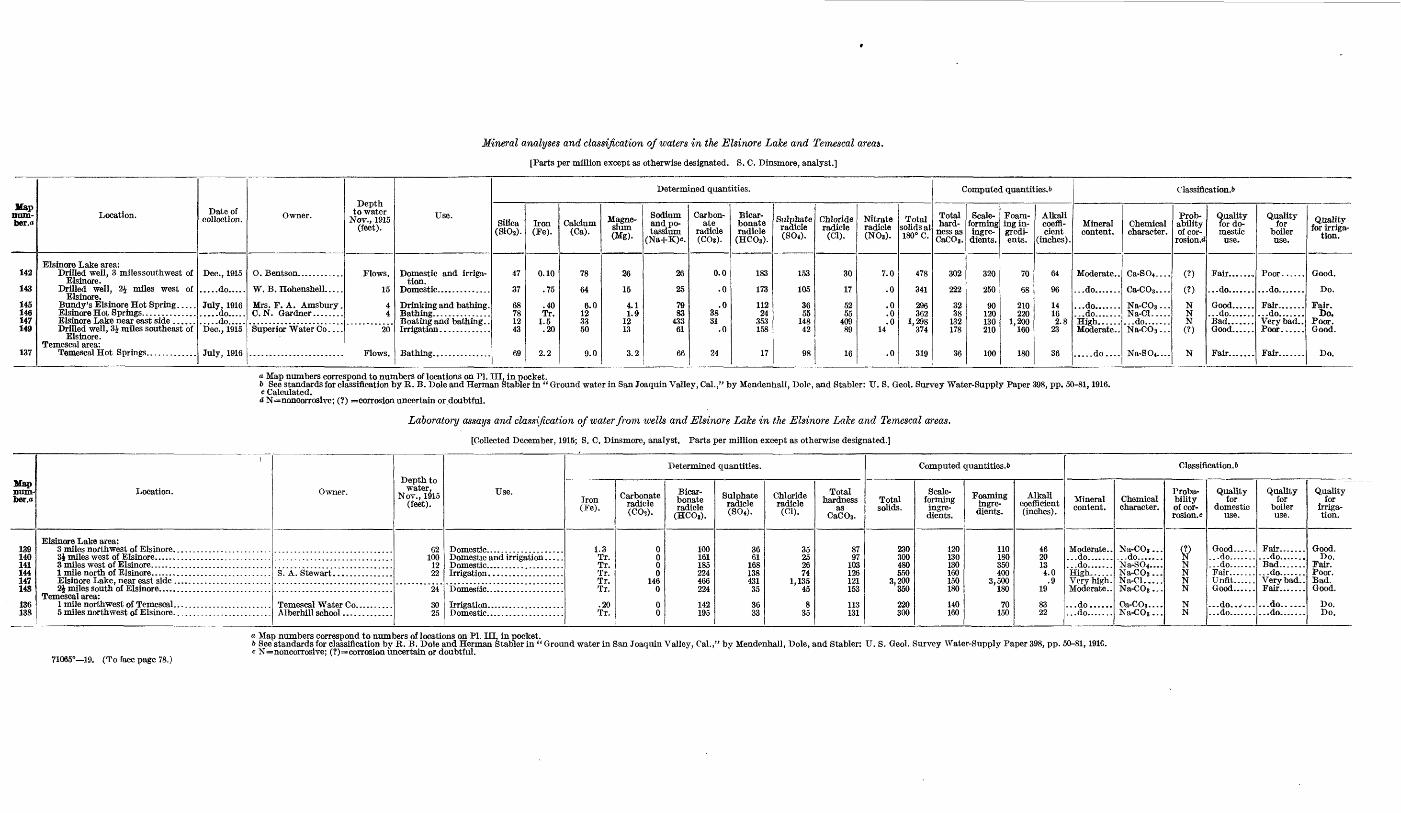
Mineral analyses and classification of waters in the Elsinore Lake and Temescal areas.
[Parts per million except as otherwise designated. S. C. Dinsmore, analyst.]
Hap mnn- ber.o
142
143
145 146 147 149
137
Location.
Elsinore Lake area: Drilled well, 3 miles southwest of
Elsinore. Drilled well, 2J miles west of
Elsinore. Bundy's Elsinore Hot Spring. .... Elsinore Hot Springs. .............Elsinore Lake near east side ......Drilled well, 3J miles southeast of
Elsinore. Temescal area:
Temescal Hot Springs. ............
Date of collection.
Dec., 1915
.....do.....
July, 1916
.....do.....Dec., 1915
July, 1916
Owner.
W. B. Hohenshell.....
Mrs. F. A. Amsbury.
Superior Water Co ....
Depth to water
Nov., 1915 (feet).
Flows.
15
4 4
20
Flows.
Use.
Domestic and irriga tion.
Drinking and bathing.
Boating and bathing. .
Bathing...............
Determined quantities.
Silica (SiOa).
47
37
68 78 12 43
69
Iron (Fe).
0.10
.75
.40 Tr.
1.5 .20
2.2
Calcium (Ca).
78
64
6.0 12 33 50
9.0
Magne sium (Mg).
26
15
4.1 1.9
12 13
3.2
Sodium and po tassium
(Na+K)c.
26
25
79 83
433 61
66
Carbon ate
radicle (COi).
0.0
.0
.0 38 31
.0
24
Bicar bonate radicle
(HCOs).
183
173
112 24
353158
17
Sulphate radicle (SO*).
153
105
36 55
148 42
98
Chloride radicle
(Cl).
30
17
52 55
40989
16
Nitrate radicle (N03).
7.0
.0
.0
.0
.0 14
.0
Total solids at 180° C.
478
341
296 362
1,298 374
319
Computed quantities. &
Total hard
ness as CaCO 3 .
302
222
3238
132 178
36
Scale- forming ingre dients.
320
250
90 120 130 210
100
Foam ing in gredi ents.
70
68
210 220
1,200 160
180
Alkali coeffi cient
(inches).
64
96
14 16 2.8
23
36
Classification.*
Mineral content.
Moderate..
...do.......
...do.......
...do.......High......Moderate..
.....do....
Chemical character.
Ca-SC-4....
Ca-CO3 ....
Na-CC-a - - -Na-Cl.....
...do.......Na-CO 3 ...
Na-SC-4....
Prob ability of cor-
rosion.d
(?)
(?)
N N N (?)
N
Quality for do mestic use.
Fair.......
...do.......
Good.........do....... Bad.......Good......
Fair.......
Quality for
boiler use.
Poor......
...do.......
Fair..........do....... Very bad. . Poor......
Fair.......
Quality for irriga
tion.
Good.
Do.
Fair. Do.
Poor. Good.
Do.
a Map numbers correspond to numbers of locations on PI. Ill, in pocket.6 See standards for classification by R. B. Dole and Herman Stabler in " Ground water in San Joaquin Valley, Cal.," by Mendenhall, Dole, and Stabler: U. S. Geol. Survey Water-Supply Paper 398, pp. 50-81,1916.c Calculated.d N=noncorrosive; (?) =corrosion uncertain or.doubtful.
Laboratory assays and classification of water from wells and Elsinore Lake in the Elsinore Lake and Temescal areas,
[Collected December, 1915; S. C. Dinsmore, analyst. Parts per million except as otherwise designated.]
Map mini"" ber.o
139 140 141 144 147 148
136 138
1
Location.
Elsinore Lake area:3 milfis northwest of TClsi«nrfi
Temescal area: 1 mile northwest of Temescal.. . ......................
Owner.Depth to
water. Nov., 1915
(feet).
62 100
12 22
24
30 25
Use.
Domestic and irrigation .....
Determined quantities.
Iron(Fe).
1.3 Tr. Tr. Tr. Tr. Tr.
.20 Tr.
Carbonate radicle (COj).
0 0 0 0
146 0
0 0
Bicar bonate radicle
(HC03).
100 161 185 224 466 224
142 195
Sulphate radicle (BOO.
36 61
168 138 431 35
36 33
Chloride radicle (01).
35 25 26 74
1,135 45
8 35
Total hardness
as CaCOs.
87 97
103 126 121 153
113 131
Computed quantities.*!
Total solids.
230 300 480 550
3,200 350
220 300
Scale- forming ingre dients.
120 130 130 160 150 180
140 160
Foaming ingre dients.
110180 350 400
3,500 180
70 150
Alkali coefficient (inches).
46 20 13 4.0 .9
19
83 22
Classification. &
Mineral content.
Moderate.. ...do....... ...do.......High......Very high. Moderate..
...do......
...do.......
Chemical character.
Na-CO3 ... ...do....... Na-S04.. Na-COs . Na-Cl... Na-CO8 .
Ca-COa.. Na-COa .
Proba bility of cor rosion, c
«>N N N N
N N
Quality for
domestic use.
Good...... ...do....... ...do.......Fair....... Unfit......Good......
...do..^...
...do.......
Quality for
boiler use.
Fair....... ...do....... Bad.......
....do....... Very bad. . Fair.......
...do......
...do.......
Quality for
irriga tion.
Good. Do.
Fair. Poor. Bad. Good.
Do. Do.
71065° -19. (To face page 78.)
a Map numbers correspond to numbers of locations on PI. Ill, in pocket.6 See standards for classification by R. B. Dole and Hennan Stabler in " Ground water in San Joaquin Valley, Cal.," by Mendenhall, Dole, and Stabler: U. S. Geol. Survey Water-Supply Paper 398, pp. 50-81,191C.c N=noncorrosive; (?)=»corrosion uncertain or doubtful.

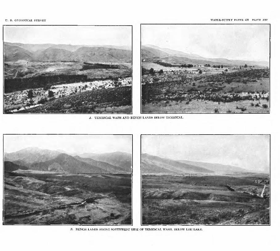
U. S. GEOLOGICAL SURVEY WATER-SUPPLY PAPER 429 PLATE XIV
A. TEMESCAL WASH AND BENCH LANDS BELOW TEMESCAL.
£. BENCH LANDS ALONG SOUTHWEST SIDE OF TEMESCAL WASH. BELOW LEE LAKE.

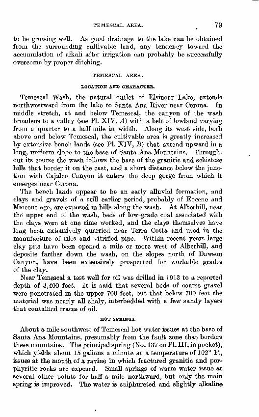
TEMESCAL ABBA. ^ 79
to be growing well. As good drainage to the lake can be obtained from the surrounding cultivable land, any tendency toward the accumulation of alkali after irrigation can probably be successfully overcome by proper ditching.
TEMESCAL AEEA.
LOCATION AND CHARACTER.
Temescal Wash, the natural outlet of Elsinore' Lake, extends northwestward from the lake to Santa Ana River near Corona. In middle stretch, at and below Temescal, the canyon of the wash broadens to a valley (see PI. XIV, A) with a belt of lowland varying from a quarter to a half mile in width. Along its west side, both above and below Temescal, the cultivable area is greatly increased by extensive bench lands (see PI. XIV, B) that extend upward in a long, uniform slope to the base of Santa Ana Mountains. Through out its course the wash follows the base of the granitic and schistose hills that border it on the east, and a short distance below the junc tion with Cajalco Canyon it enters the deep gorge from which it emerges near Corona.
The bench lands appear to be an early alluvial formation, and clays and gravels of a still earlier period, probably of Eocene and Miocene age, are exposed in hills along the wash. At Alberhill, near the upper end of the wash, beds of low-grade coal associated with the clays were at one time worked, and the clays themselves have long been extensively quarried near Terra Cotta and used in the manufacture of tiles and vitrified pipe. Within recent years large clay pits have been opened a mile or more west of Alberhill, and deposits farther down the wash, on the slopes north of Dawson Canyon, have been extensively prospected for workable grades of the clay.
Near Temescal a test well for oil was drilled in 1913 to a reported depth of 3,400 feet. It is said that several beds of coarse gravel were penetrated in the upper 700 feet, but that below 700 feet the material was nearly all shaly, interbedded with a few sandy layers that contained traces of oil.
HOT SPRINGS.
About a mile southwest of Temescal hot water issues at the base of Santa Ana Mountains, presumably from the fault zone that borders these mountains. The principal spring (No. 137 on PL III, in pocket), which yields about 15 gallons a minute at a temperature of 102° F., issues at the mouth of a ravine in which fractured granitic and por- phyritic rocks are exposed. Small springs of warm water issue at several other points for half a mile northward, but only the main spring is improved. The water is sul|>hureted and slightly alkaline
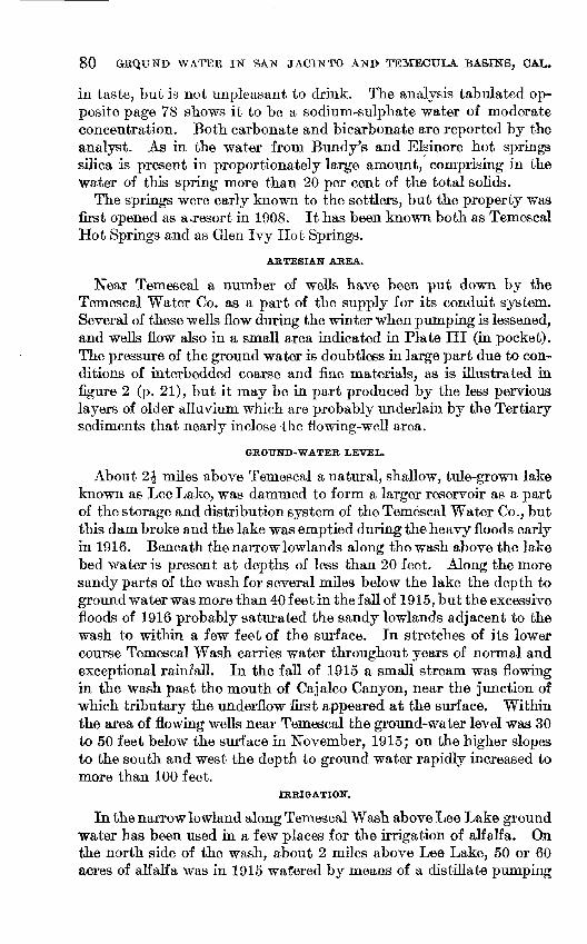
80 GEQUKD WATER IN SAIST JACIjSTTO AISTB TEMBCULA BASINS, CAL.
in taste, but is not unpleasant to drink. The analysis tabulated op posite page 78 shows it to be a sodium-sulphate water of moderate concentration. Both carbonate and bicarbonate are reported by the analyst. As in the water from Bundy's and Elsinore hot springs silica is present in proportionately large amount, comprising in the water of this spring more than 20 per cent of the total solids.
The springs were early known to the settlers, but the property was first opened as a.resort in 1908. It has been known both as Temescal Hot Springs and as Glen Ivy Hot Springs.
ARTESIAN AREA.
Near Temescal a number of wells have been put down by the Temescal Water Co. as a part of the supply for its conduit system. Several of these wells flow during the winter when pumping is lessened, and wells flow also in a small area indicated in Plate III (in pocket). The pressure of the ground water is doubtless in large part due to con ditions of interbedded coarse and fine materials, as is illustrated in figure 2 (p. 21), but it may be in part produced by the less pervious layers of older alluvium which are probably underlain by the Tertiary sediments that nearly inclose -the flowing-well area.
GROUND-WATER LEVEL.
About 2£ miles above Temescal a natural, shallow, tule-grown lake known as Lee Lake, was dammed to form a larger reservoir as a part of the storage and distribution system of the Temescal Water Co., but this dam broke and the lake was emptied during the heavy floods early in 1916. Beneath the narrow lowlands along the wash above the lake bed water is present at depths of less than 20 feet. Along the more sandy parts of the wash for several miles below the lake the depth to ground water was more than 40 feet in the fall of 1915, but the excessive floods of 1916 probably saturated the sandy lowlands adjacent to the wash to within a few feet of the surface. In stretches of its lower course Temescal Wash carries water throughout years of normal and exceptional rainfall. In the fall of 1915 a small stream was flowing in the wash past the mouth of Cajalco Canyon, near the junction of which tributary the underflow first appeared at the surface. Within the area of flowing wells near Temescal the ground-water level was 30 to 50 feet below the surface in November, 1915; on the higher slopes to the south and west the depth to ground water rapidly increased to more than 100 feet.
IRRIGATION.
In the narrow lowland along Temescal Wash above Lee Lake ground water has been used in a few places for the irrigation of alfalfa. On the north side of the wash, about 2 miles above Lee Lake, 50 or 60 acres of alfalfa was in 1915 watered by means of a distillate pumping
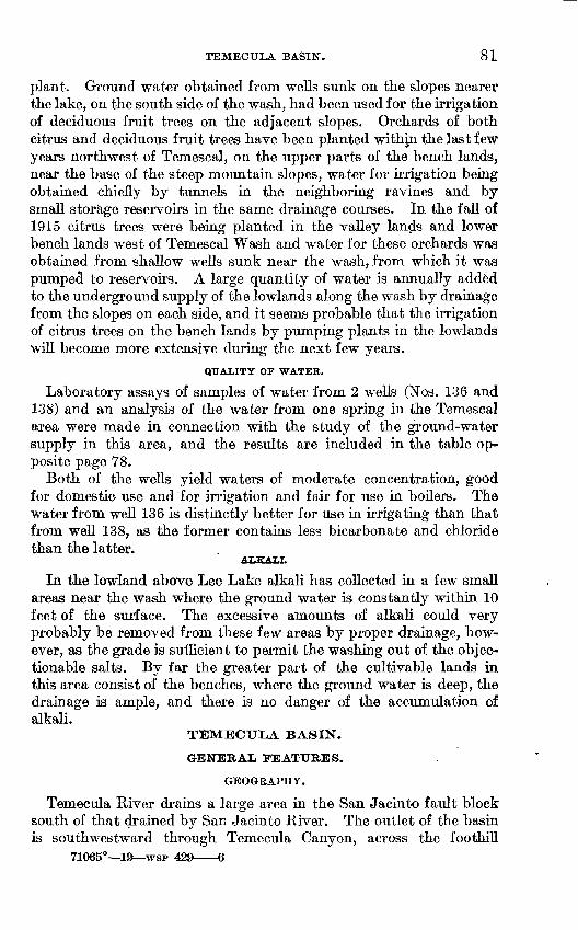
TEMECULA BASIN. 81
plant. Ground water obtained from wells sunk on the slopes nearer the lake, on the south side of the wash, had been used for the irrigation of deciduous fruit trees on the adjacent slopes. Orchards of both citrus and deciduous fruit trees have been planted withjn the last few years northwest of Temescal, on the upper parts of the bench lands, near the base of the steep mountain slopes, water for irrigation being obtained chiefly by tunnels in the neighboring ravines and by small storage reservoirs in the same drainage courses. In the fall of 1915 citrus trees were being planted in the valley lands and lower bench lands west of Temescal Wash and water for these orchards was obtained from shallow wells sunk near the wash, from which it was pumped to reservoirs. A large quantity of water is annually added to the underground supply of the lowlands along the wash by drainage from the slopes on each side, and it seems probable that the irrigation of citrus trees on the bench lands by pumping plants in the lowlands will become more extensive during the next few years.
QUALITY OF WATER.
Laboratory assays of samples of water from 2 wells (Nos. 136 and 138) and an analysis of the water from one spring in the Temescal area were made in connection with the study of the ground-water supply in this area, and the results are included in the table op- posite page 78.
Both of the wells yield waters of moderate concentration, good for domestic- use and for irrigation and fair for use in boilers. The water from well 136 is distinctly better for use in irrigating than that from well 138, as the former contains less bicarbonate and chloridethan the latter.
ALKALI.In the lowland above Lee Lake alkali has collected in a few small
areas near the wash where the ground water is constantly within 10 feet of the surface. The excessive amounts of alkali could very probably be removed from these few areas by proper drainage, how ever, as the grade is sufficient to permit the washing out of the objec tionable salts. By far the greater part of the cultivable lands in this area consist of the benches, where the ground water is deep, the drainage is ample, and there is no danger of the accumulation of alkali.
TEMECULA BASIN.
GENERAL FEATURES.
GEOGRAPHY.
Temecula River drains a large area in the San Jacinto fault block south of that drained by San Jacinto River. The outlet of the basin is southwestward through Temecula Canyon, across the foothill
71065° 19 WSP 429 6
82 GROUND WATER IN SAN JACINTO AND TEMECULA BASINS, OAL.
region, and through Santa Margarita River to the ocean. In the present paper, however, only that part of the basin is considered which lies above the head of Temecula Canyon.
On the north the divides that separate the basin from the drainage tributary to San Jacinto River are in most places sharp, but a gap in the high land is occupied by Paloma Valley, and in this valley the divide is ill denned. On the northwest also the divide between water that flows southeast past Murrieta and that which flows in the opposite direction to Elsinore Lake is not well defined, but the lowest point of the divide is probably in or just west of Wildomar. Southward to Temecula Canyon and eastward from that gap the divides that sepa rate the upper tributaries of Temecula River from those that'join it below the canyon and from tributaries of San Luis Rey River are formed by the Santa Rosa Mountains and the rugged granitic slopes that culminate in the masses of Agua Tibia Mountain and Aguanga Mountain. On the east the Temecula basin is separated from drain age lines that trend toward Colorado Desert in part by mountainous divides, but in part also by less definite divides in Babtiste, Chihuahua, and Dodge valleys.
The highest points in the basin are Thomas Mountain, 6,823 feet above sea level, on the northeastern border, and Palomar Mountain^ 6,126 feet, on the southern. A number of other mountains and ridges along the divide on the east attain elevations of more than 5,000 feet. The eastern part of the basin consists in large part of upland valleys, 2,000 to 4,500 feet above sea level, but most of the western part is less than 1,500 feet in elevation.
The higher mountain slopes are covered with pine and the some what lower slopes are partly clothed with oaks, but over most of the basin the vegetation consists of brush and scrubby trees. The valley lands contain many open areas.
GEOLOGY.
In by far the greater part of the Temecula basin the surface is imme diately underlain by ancient crystalline rocks granites, gneisses, and schists. The prevailing type of rock is a coarse-grained gray granite, but gneissic rocks are common. Near the northern border a zone of mica schist and quartzite, a mile or more in width, which extends from the vicinity of the abandoned Goodhope mine southeastward and includes Bell Mountain and the abandoned Leon mine, in the San Jacinto basin, continues 6 or 8 miles farther southeast, to the vicinity of Black Mountain in the Temecula basin. On the western border of the basin Santa Rosa Mountains are also composed largely of dark fine-grained mica schist which is associated with slates that are probably of Triassic age. At Temecula Canyon the material changes to coarse-grained gray granite, however, and thence southeastward

TEMECULA BASIS'. 83
the mountains that form the divide are composed of granitic and gneissic rocks.
Several flat-topped areas along the crest of the Santa Rosa Range, known as mesas or table-lands, are formed by flows of basaltic lava. One tongue of lava extends part way down the side of the mountain about 1^ miles south of Wildomar, and a similar, larger flow that ex tends down the western side of the divide has been described by Fairbanks.1 Volcanic rock is also found about 10 miles east of Temecula, at the mouth of Nigger Canyon, where the material con sists of agglomerate tuffs that cover the slopes from the river channel to a height of several hundred feet.
In the lower part of the basin the bedrock of ancient crystalline material is covered deeply by gravels and sandy clays, which are thickest in the rolling hills north and east of Temecula. These clays and gravels were possibly deposited when the outlet through Temecula Canyon did not exist and the valley may have been cov ered by a lake. From the present geologic knowledge of the region it is not known whether Temecula Canyon has been formed mainly by erosion or whether it has become the outlet as a result of earth movements that uplifted the probable former outlet by way of Temescal Wash to a level slightly higher than that of the Temecula gap. The drainage divide at Wildomar is only 250 feet above the head of Temecula Canyon, but the bedrock is probably at a lower level beneath the valley at Wildomar than where it is exposed in the river channel at the head of the canyon.
The relation of the sandy clays and gravels to the Tertiary (Eocene and Miocene) clays and gravels that form the hills near Terra Cotta and Alberhill and are present on the slopes at several places along
. Temescal Wash has not been carefully studied. The sedimentary beds of the Temecula basin are believed, however, to have been deposited later, probably in Pliocene or early Pleistocene time, and to be more nearly contemporaneous with the deposits of older allu vium on the slopes east of San Jacinto. Bedding structure is not well shown in the deposits of the Temecula basin, but in general they seem to form a shallow syncline or trough whose axis corresponds approximately to the present valley lowlands.
Bench lands underlain by materials washed from the adjacent hills are found along the western side of the valley, between Wildomar and Murrieta, and on the eastern side of the valley on the higher slopes east of Wildomar. A small area of bench land has also been formed at the valley side south of Temecula Canyon.
The small valley areas in the eastern part of the basin seem to be underlain in part by material washed from the surrounding hills but chiefly by residual material resulting from the disintegration of the bedrock.
i Fairbanks, H. W., Geology of San Diego County; also of portions of Orange and San Bernardino counties: California State Mineralogist Eleventh Kept., p. 103,1893.
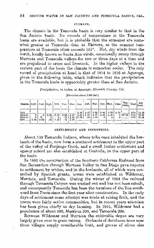
84 GROUND WATER IN SAN JACINTO AND TEMECULA BASINS, CAL.
CLIMATE.
The climate in the Temecula basin is very similar to that in the San Jacinto basin. No records of temperature in the Temecula basin are available, but it is probable that the extremes are some what greater at Temecula than at Elsinore, as the summer tem perature at Temecula often exceeds 105°. Hot, dry winds from the north, locally known as Santa Ana winds, occasionally sweep through Murrieta and Temecula valleys for two or three days at a time and are prejudicial to crops and livestock. In the higher valleys in the eastern part of the basin the climate is somewhat cooler. The only record of precipitation at hand is that of 1914 to 1916 at Aguanga, given in the following table, which indicates that the precipitation in the Temecula basin is appreciably greater than at San Jacinto.
Precipitation, in inches, at Aguanga, Riverside County, Cal.
[Elevation about 2,000 feet.]
Season.
1914.... 1914-15.. 1915-16..1916....
July.
......
00.04
Aug.
""6"T.
0.04
Sept.
"6."22"
.08
Oct.
"6."58"
01.50
Nov.
"6."99"
.73
.12
Dec.
"2~27"
2.312.65
Jan.
5.68 5.37
17.85
Feb.
3.97 5.91 .35
Mar.
0.82 1.57 1.68
Apr.
0.96 2.20
0
May.
0.12 1.58
0
June.
0.18 0 0
Sea sonal.
20."69"
......
Year.
1914 1915 1916
An nual.
15. 79 19.67 24.31
SETTLEMENT AND INDUSTRIES.
About 150 Temecula Indians, whose tribe once inhabited the low lands of the basin, now form a scattered settlement in the upper part of the vafiey of Penjango Creek, and a small Indian settlement and agency school are also established at Coahuila, in the upper part of the basin.
In 1883 the construction of the Southern California Railroad from San Bernardino through Murrieta Valley to San Diego gave impetus to settlement by whites, and in the lowlands, all of which were con trolled by Spanish grants, towns were established at Wildomar, Murrieta, and Temecula. During the winter of 1884 the railroad through Temecula Canyon was washed out and has not been rebuilt, and consequently Temecula has been the terminus of the line south ward from. Perris since the first year after construction. In the early days of settlement some attempt was made at raising fruit, and the towns were fairly active communities, but in recent years attention has been given chiefly to dry farming. In 1915, Wildomar had a population of about 100, Murrieta 300, and Temecula 200.
Between Wildomar and Murrieta the cultivable slopes are very largely given over to grain raising. Orchards of deciduous trees near these villages supply considerable fruit, and groves of olives also
. TEMECULA BASIF. 85
occupy tracts on the eastern slopes. A number of apiaries on each side of the valley produce much honey during years of favorable growth of wild flowers. Between Murrieta and Temecula, where the valley of Murrieta Creek widens, considerable areas of natural pasture land are given over to stock raising. On the east side of the valley, on somewhat higher lands bordering Santa Gertrudis Creek, alfalfa has been planted within the last few years, water for its irrigation being supplied by a pumping plant at the upper end of the field.
The valley of Temecula River,-controlled by the Pauba Rancho, has been developed into a great stock range. The higher lands are used for grazing and the lowlands are planted with alfalfa for the stock. A dairy is also operated in connection with this stock ranch.
The higher lands in the several small valleys in the eastern part of the basin have long been occupied by ranches which produce some hay, grain, and fruit, and use the surrounding slopes for grazing a few head of cattle and the fields for the establishment of apiaries. During 1913 to 1916 a number of people took up homesteads in Babtiste Valley, with the intention of raising grain.
SURFACE WATER.
The western part of the Temecula basin is drained by Murrieta Creek and its tributaries. The main stream heads in the slopes west of Murrieta, but the greater part of its drainage basin is east of the main valley land. The tributaries of Murrieta Creek as a rule carry water only during rainy periods, though the largest tributary, Santa Gertrudis Creek, usually has a small amount of water in the lower part of its course throughout the year. The channel of the main creek is in most places wide and sandy and is bordered by low banks that allow flood water to spread over the adjacent lowlands. During the sum mer and fall months the channel is usually dry in this part, but near Temecula it is entrenched 10 or 12 feet deep in the valley alluvium and has a small perennial flow. On December 1, 1915, the discharge of Murrieta Creek just above its junction with Temecula River at the head of Temecula Canyon, was 1 second-foot. The discharge of Teme cula River just above its junction with Murrieta Creek on the same date was 10.3 second-feet.'
Temecula River drains the eastern part of the basin through numerous tributaries. The main stream and its tributaries are, like most streams of southern California, intermittent in flow, though locally the water rises to the surface and flows in small amount throughout the year. About 10 miles above the head of Temecula Canyon the river flows through Nigger Canyon, and for 3 or 4 miles below this canyon its channel is wide, sandy, and usually dry during the summer and fall. In the last 6 miles of its course above Temec ula Canyon the channel becomes narrower and is entrenched a few feet in the valley alluvium, and here the stream is perennial.

86 GROUND WATER IN SAN JACINTO AND TEMECTJLA BASINS, CAT*
Both Nigger Canyon and the head of Temecula Canyon have long been recognized as feasible dam sites for the storage of water for irrigation. A reservoir at the lower site at an elevation of about 1,000 feet could store water for the irrigation of foothill lands to the south, in the neighborhood of Fallbrook, at elevations of 600 to 900 feet. The Nigger Canyon or Pauba ranch site, at an elevation of about 1,250 feet, could store water for the irrigation of lands in the Fallbrook region, and, if sufficient water were available, for lands in the neighborhood of Rainbow as well as in Murrieta and Temecula valleys. The area of the drainage basin above the head of Temecula Canyon is 550 square miles and above Nigger Canyon is 320 square miles. A large part of the basin, however, consists of gently sloping lands from which the run-off is probably slight. Paloma, French, and Los Alamos valleys, in the north, and Coahuila, Terwilliger, Chi huahua, and Oakgrove valleys, in the east, comprise such lands from which the run-off is doubtless small.
No systematic record of stream flow in the Temecula basin has been undertaken by the Geological Survey, but a record of daily gage height on Temecula River three-fourths of a mile above its junction with Murrieta Creek was kept during 1906.1 The total discharge during the year can not be determined, as the channel continually shifted throughout the period of observation. Exami nation of the daily gage-height record together with the current- meter measurements of discharge made during the year indicates, however, that Temecula River, whose drainage area above the gage comprises 345 square miles, can hardly have discharged one-tenth as much water as did San Luis Rey River near Pala, about 10 miles south of the Temecula River station, during the same year. During 1906 the San Luis Rey discharged 111,000 acre-feet of water from a drainage area of 318 square miles.2 In both 1905 and 1906 the precipitation recorded at Elsinore was nearly double the mean annual rainfall at that place. During winters of average rainfall neither the San Luis Rey nor the Temecula would discharge nearly as much water as each did, in 1906.
DESCRIPTION BY AREAS.
MURRIETA VALLEY.
LOCATION AND CHARACTER.
Murrieta Valley extends approximately from the head of Temecula Canyon northwest to Wildomar, a distance of about 12 miles. Between Temecula and Murrieta the valley is one-half to three- quarters of a mile wide, but above Murrieta the lowland, is hardly a
1 Clapp, W. B., The surface water supply of California, 1906: U. S. Geol. Survey Water-Supply Paper 213; pp. 76-78,1907.
2 Idem, p. 76.
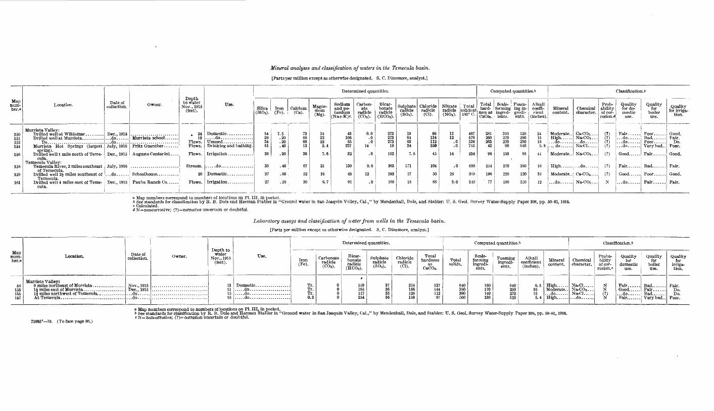
Mineral analyses and classification of waters in the Temecula basin.
[Parts per million except as otherwise designated. S. C. Dinsmore, analyst.]
Map num- ber.o
150 151 152 154
156
158
159
161
Location.
Murrieta Valley: Drilled well at Wildomar ......... Drilled well at Murrieta. ..........
Do............................Murrieta Hot Springs (largest
spring). Drilled well 1 mile north of Teme
cula. Temecula Valley:
Temecula River, 2 miles southeast of Temecula.
Drilled well 2J miles southeast of Temecula.
Drilled well 4 miles east of Teme cula.
Date of collection.
Dec., 1915 ...do...... ...do......July, 1916
Dec., 1915
July, 1916
...do......
Dec., 1915
Owner.
Auguste Cantarini. ....
Depth to water
Nov., 1915 (feet).
. 24 10
Flows. Flows.
Flows.
Stream.
20
Flows.
Use.
.....do................
Drinking and bathing.
.....do................
Determined quantities.
Silica (SiOi).
54 29 34 51
38
33
37
27
Iron(Fe).
7.5 .20 .20 .40
.20
.40
.80
.20
Calcium(Ca).
73 68 69 13
26
67
52
20
Magne sium (Mg).
24 22 22 2.4
7.6
21
16
6.7
Sodium and po tassium
(Na+K)c.
43 10685
237
32
139
43
91
Carbon ate
radicle (CO.).
0.0 .0 .0
14
.0
9.6
12
.0
Bicar bonate radicle
(HCOg).
273 273 273
19
102
263
193
168
Sulphate radicle (SOO-
19 64 63 24
7.8
171
17
18
Chloride radicle
(Cl).
86 134 112 350
45
104
50
83
Nitrate radicle (NOg).
12 12
.0
.0
14
.0
28
3.0
Total solids at 180° C.
467 576 524 745
234
688
369
310
Computed quantities. &
Total hard
ness as CaCog.
281 260 263
42
96
254
196i 77
Scale- ; Foam- forming ing in- ingred- : grcdi- ients. ents.
310 120 270 290 270 230 90 640
130 86
270 380
220 120
100 250
Alkali coeffi cient
(inches).
24 1518 5.8
44
16
34
12
Classification^
Mineral content.
Moderate. . High. .....
...do......
Moderate. .
High......
Moderate. .
...do......
Chemical character.
Ca-COa. . . . Na-COg... ...do......Na-Cl.....
Na-COg...
--.do.--...
Ca-COs. . . .
Na-COs - . .
Prob ability of cor
rosion, d
(?) (?) (?) (?)
(?)
(?)
(?)
N
Quality for do mestic
use.
...do......
...do......
...do......
Good......
...do......
Quality for
boiler use.
Bad....... Poor ......Very bad. .
Fair.......
Bad.......
Poor......
Fair......
Quality for irriga
tion.
Good. Fair.
Do. Poor.
Good.
Fair.
Good.
Fair.
a Map numbers correspond to numbers of locations on PI. Ill, in pocket.& See standards for classification by R. B. Dole and Herman Stabler in "Ground water in San Joaquin Valley, Cal.," by Mendenhall, Dole, and Stabler: U. S. Geol. Survey Water-Supply Paper ;c Calculated.d N=noncorrosive; (?)=corrosive uncertain or doubtful.
Laboratory assays and classification of water from ivells in the Temecula basin.
[Parts per million except as otherwise designated. S. C. Dinsmore, analyst.]
3, pp. 50-81, 1916.
Map num- ber.o
58 153 155 157
Location.
Murrieta Valley:
Date of collection.
Nov., 1915T)AP 1Q1 f\
...do......
...do......
Owner.Depth to
water Nov., 1915
(feet).
13 11 15 15
Use.
Domestic ......................do.........................do.........................do....................
Determined quantities.
Iron(Fe).
Tr. Tr. Tr. 0.3
Carbonate radicle (COi).
0 0 0 0
Bicar bonate radicle
(HCOg).
t
159 185 117 254
Sulphate radicle (800.
37 36 33 36
Chloride radicle
(Cl).
258 188 128 158
Total hardness
as CaCO3 .
127 144 112 97
Computed quantities. &
Total solids.
640 380 390 560
Scale- forming ingredi
ents.
160 170 140 130
Foaming ingredi
ents.
540 230 270 510
Alkali coefficient (inches).
6.5 1615 5.4
Mineral content.
High......Moderate. . ...do...... High......
Classification. 6
Chemical character.
Na-Cl.....Na-COg...Na-Cl..... ...do......
Proba bility of cor
rosion, c
N N (?)N
Quality for
domestic use.
Good...... ...do......
Quality for
boiler use.
Bad.......Fair...... Bad....... Very bad. .
Quality for
irriga- . tion.
Fair. Do. Do.
Poor.
71065° 19. (To face page 86.)
o Map numbers correspond to numbers of locations on PL HI. in pocket.& See standards for classification by R. B. Dole and Herman Stabler in "Ground water in San Joaquin Valley, Cal.," by Mendenhall, Do-le, and Stabler: U. S. Geol. Survey Water-Supply Paper 398, pp. 50-81,1916.cN=noncorrosive; (?)= corrosion uncertain or doubtful.

MUBRIETA VALLEY. 87
quarter of a mile wide. The lowland adjacent to Murrieta Creek is bordered on each side by gentle slopes that rise on the southwest to the steep front of Santa Rosa Mountains and on the northeast to a wide area of rolling hills which are made up of sedimentary deposits (See PI. Ill, in pocket.) The lowest lands are devoted chiefly to the pasturing of stock and much of the land forming the adjacent slopes is also given over to grazing, but large fields are cultivated for the dry farming of wheat, oats, and barley.
EOT SPRINGS.
About 4 miles east of Murrieta, at Murrieta Hot Springs, near the northern border of the older sedimentary deposits, a large flow of hot water issues, presumably rising from a fracture or subsidiary fault, of the great fault zone that borders the southern side of the Temecula basin. Three principal springs yield water at temperatures of 134° to 136° F., and the total flow is about 75 gallons a minute. An analysis of water from one of the springs (No. 154 on PI. Ill, in pocket), included in the table facing page 86, indicates that the water is essentially a solution of common salt in water that contains carbon dioxide and hydrogen sulphide. It is of fair quality for domestic use but poor for irrigation or for steam making.
ARTESIAN AREAS.
A test well sunk by the town about 1890 near the railroad station at Murrieta is said to have obtained a strong artesian flow from a depth of 250 to 300 feet. The well was not used, however, and its flow gradually lessened, largely no doubt because of the clogging of the perforations in the casing. In 1903, during a period of unusually low precipitation, the well ceased to flow, and in March, 1904, the water stood 2^ feet below the surface. It began to flow again about 1910 and in the fall of 1915 was still slightly overflowing the top of the casing, 3 feet above the ground. Several other wells were early sunk near Murrieta, in attempts to obtain flowing water, but at 200 or 300 feet quicksand was encountered and the wells could not be completed.
In 1912 or 1913 a well sunk by Mr. Dodd to a reported depth of nearly 600 feet beside the creek channel a mile south of Murrieta obtained a slight artesian flow, and a well that was put down about 3 miles farther southeast, near Santa Gertrudis Creek, is said to flow in the winter. Although neither of these two deep wells obtained strong artesian flows, each supplied a pumping plant in 1915.
The most successful flows in the valley of Murrieta Creek are obtained from four wells sunk in 1913 on the property of Mr. Auguste Cantarini (well 156, PI. Ill, in pocket) a mile north of Temecula. Three of these wells, sunk close together to a depth of 246 feet and connected to an outlet 8 feet below the surface, obtained flowing

88 GROUND WATER IN SAN JACINTO AND TEMECULA BASINS, CAL.
water at a depth of 146 feet, and in November, 1915, yielded a total flow of 75 gallons a minute at a temperature of 69° F. In the fourth well, 303 feet deep, put down a quarter of a mile farther north, water was obtained at a depth of 276 feet and was flowing about 10 gallons a minute in November, 1915. The head on the water-bearing beds penetrated in these wells seems to be due to the fact that the sands and gravels in which the wells were drilled dip gently toward the val ley from the higher lands to the north and northeast. Other wells sunk to depths of about 500 feet in the lowland near Temecula are said to have failed to obtain flowing water.
Along the eastern edge of the valley between Murrieta and Teme cula a number of springs issue at the lower margin of the deposits of older sands and gravels. (See PI. Ill, in pocket.) These springs and the fact that the most successful artesian wells (those of Mr. Cantarini) have been drilled into the older sediments indicate that the artesian water is derived from layers in those sediments and not from the later valley alluvium. The character of the valley-fill, so far as could be learned, also indicates that it does not contain artesian water-bearing beds. One well put down near Murrieta through the quicksand to a depth of 520 feet passed through two layers of black muck, possibly old swamp material, and also penetrated a log at a depth of 200 or 300 feet. The material in the last 100 feet was a white, compact clay, grading into harder, more gritty, material. In another test well, 1J miles east of Murrieta, sunk to a depth of 180 feet, frag ments of resin and complete shells of nuts resembling pine nuts were brought up in the drillings. Fragments of partly carbonized twigs and roots have been encountered in other wells sunk near Murrieta. These bits of vegetal matter indicate that the valley fill is deep and of a relatively recent period of deposition, but well-defined layers of sand or gravel containing water under pressure do not seem to be present. In several wells no good water-bearing sands were found below about 75 feet.
GROUND-WATER LEVEL.
Throughout the lowland of Murrieta Valley the ground-water level is within 20 feet of the surface, and beneath the greater part the depth to water is less than 10 feet. At Murrieta wells in the main part of town obtain water at depths of 12 to 18 feet, but in the bench lands on each side depths of 30 to 40 feet to water were noted. The water table slopes upward at a perceptible rate beneath the bordering lands, however, so that the differences in the depth to water beneath the lowlands and the higher slopes are not so great as the differences in elevation. The conditions are the same at Temecula, where water is obtained in the lower part of the town at a depth of about 20 feet and on the adjacent slopes at depths of 40 or 50 feet. At Wildomar domestic wells obtain water at depths of 25 to 35 feet.
MUKRIETA VALLEY. 89
Measurements of the depth to water in numerous wells throughout Murrieta Valley, made in March, 1904, and again in November, 1915, indicate that at the later date the water level was noticeably higher than at the earlier. In some wells on the borders of the valley the rise was as much as 10 feet, and in wells in the lowland it ranged from 1 to 5 feet. The winter of 1903-4 was one of exceptionally low pre cipitation, only 6.65 inches of rain being recorded at Elsinore, whereas the average for a number of seasons is more than 13 inches; in March, 1904, therefore, the water level was doubtless low. The rainfall in the winter of 1913-14 was nearly the average and that in 1914-15 somewhat more than the average for the region, and in November, 1915, the ground-water level was probably higher than usual.
IRRIGATION.
In 1915 the Dodd well, near Murrieta, furnished water for irrigating an adjacent alfalfa field, and the plant near Santa Gertrudis Creek supplied another, much larger field of alfalfa. The flowing wells of Mr. Cantarini, near Temecula, also supplied a small field of alfalfa. Other irrigation in Murrieta Valley in 1915 was limited to the watering of a few orchard trees from domestic wells, at the towns of Wildomar, Murrieta, and Temecula.
It is possible that wells sunk to depths of 500 feet or more in the lowlands of Murrieta Valley might be more successful in obtain ing flows than were the test wells put down prior to 1915, but it is improbable that flows sufficiently large for extensive irriga tion can be obtained. Throughout the lowland the ground water is within easy reach by pumping, but at the time of examination no exhaustive tests of ,the yield of shallow wells had been made, and it is possible that the shallow water-bearing sands are too fine grained to yield large supplies of water for irrigation. The somewhat alkaline character of the shallow water and of the soil in some parts of the lowland may prevent successful development of much of the land along Murrieta Creek for the growing of irrigated crops. The soil of the adjacent slopes seems to be good, however, and water for the irriga tion of orchards on these higher lands could perhaps be pumped from wells sunk in the less alkaline parts of the lowlands.
QUALITY OF WATER.
Analyses or laboratory assays have been made on eight well waters and one spring water in Murrieta Valley, including water from the flowing well at Murrieta and one of Mr. Cantarini's flowing wells.
Except for the water of one well (No. 157) at Temecula, which contains so much chloride and bicarbonate that it is unsuitable for irrigation, the sampled well waters from Murrieta Valley range in quality from fair to good for domestic uses and for irrigation. Two
90 GROUND WATER IN SAN JACINTO AND TEMECULA BASINS, CAL.
wells (Nos. 151 and 152) at Murrieta and Mr. Cantarini's flowing well (No. 156) yield sodium-carbonate waters. The first two waters are rather high in total solids, but the water from the Cantarini well contains only 234 parts per million. At Wildomar the well sampled (No. 150) yields a rather hard calcium-carbonate water. The well 1^ miles east of Murrieta (No. 153) is shown by the laboratory assay to yield a sodium-carbonate water lower in total solids than that from the well at Wildomar (No. 150) and only half as hard.
ALKALI.
In the lowland along Murrieta Creek for 2 or 3 miles above Teme cula, the ground-water level is within 6 or 8 feet of the surface, and the continual evaporation from this moist area has caused the con centration of alkali. Chemical examination of the waters tested indicates that in most of them sodium is the predominant base. If chloride or sulphate is also present in large amount, "white alkali" may form upon concentration of the water. In six of the waters analyzed (Nos. 151, 152, 153, 156, 158, and 161 on PL III, in pocket) carbonate is predominant among the acids and sodium is predominant among the bases. Such waters would form "black alkali" upon evaporation. Most of this lowland could probably be improved by ditching and drainage, but the adjacent slopes seem to offer lands that are better adapted to agriculture. The lowlands produce a fair stand of natural forage and can probably be best used as at present for grazing.
TEMECULA VALLEY.
LOCATION AND CHARACTER,
Temecula Valley extends downstream from the mouth of Nigger Canyon a distance of about £ miles to the head of Temecula Canyon. Below Nigger Canyon the lowland rapidly opens to a width varying from three-quarters of a mile to fully a mile, and the stream channel is wide, sandy, and unusually* dry throughout the later months of the year. Three or four miles below Nigger Canyon the channel is cut to a depth of a few feet in the valley alluvium, and the water rises to the surface and forms a perennial stream. Along this stretch the valley land is only half a mile wide, but 1£ miles above Temecula Canyon the lowland widens southeastward up the tributary'valley of Penj ango Creek. A view of the lower part of the valley, looking west ward toward Temecula Canyon, is given in Plate XIII, A. On the south side of the valley for 2 miles below Nigger Canyon and along the western side of Penj ango Creek the granitic rocks of the bordering mountains adjoin the edge of the lowland, but along the rest of the southern side of the valley and the entire length of its northern side the hills are composed of the clays and gravels that occupy a consid erable area in the Temecula basin. (See PI. Ill, in pocket.)
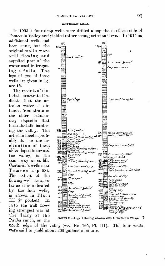
TEMECULA VALLEY.
ARTESIAN AREA.
In 1903-4 four deep wells were drilled along the northern side of Temecula Valley and yielded rather strong artesian flows. In 1915 no additional wells had been sunk, but the original wells were still flowing and supplied part of the water used in irrigat- ing alfalfa. The logs of two of these wells are given in fig ure 15.
The records of ma terials penetrated in dicate that the ar tesian water is ob tained from strata in the older sedimen tary deposits that form the hills border ing the valley. The artesian head is prob ably due to the in clination of these older deposits toward the valley, in the same way as at Mr. Cantarini's wells near Temecula (p. 88). The extent of the flowing-well area, so far as it is indicated by the four wells, is shown in Plate III (in pocket). In 1915 the well flow ing strongest was at the dairy of the Pauba ranch, on thenorth edge of the valley (well No. 160, PI. III), were said to yield about 200 gallons a minute.
160feet
15
280 264
30f
3I£ §26
3C
all3^2 348 356
37( 378388
AIS
438
4-8
SO*
ft S3
B46 S5C
:;!
1
-is
3
H
H
s^
is
E
<g;
S|
H
as.-S1
H
§
Stack sart 1
*"
Sand, water'
Red C/ay (Sand: a little W^tSPj*1* /Blue '.c/ay r"/Send.- watei* rBlue clay /Sand Hardpan . - - - ~Grffvel; ftotvirtg w£ter Hardpan. Grave/ ; flowing water Blue c/ay SandC/ay Grave/ ; f/ow/n$ water
Hardpan ancf G/ay
Clay
Fine sijnd
Clay
Sand and 'grave/ C/ay
Sand and £ra(/e/i flowing water C/ay Sand Blue clay Sand sffd grave f C/ay with rocks Sand and grave/
161Feet
ssS3
'63
360 365
||
i4.51~^°4-8
SO
51
11 S3
^
-~z
^
4
n
s
H^s
ms^^
S? a- === ':::
P
^"
S£- ^f^m^
* So//
Ssncf and gr&vet
Clay <?nd sand
C/ay &nd harcfp§i^ '
Sand dntf 'graver,~\ water, small flQ.w>
Clay and hardjy$t3
Fine sand/ivatef Coarse sandtjCtay snd sand Coarse sand
\Sa/7c/ and clay
Sand, water, sma// fk>H?
Sand and c/ay
Fine sand Gravel ' Clay and sandCoffr.se sandClay Sandy c/ay SandC/ay with lime roctf Sandy c/ay , Sand and grsve/f a little wafer Sandy clay -Grav§l ' Sandy c/ay \ \Coarse ssfhd and gnave/j ) flowing water Satidy clay
FIGURE 15. Logs of flowing artesian wells in Temecula Valley. "1
The four wells
92 GROUND WATER, IN SAN JACINTO AND' TEMECULA BASINS, CAL,
GROUND-WATER LEVEL.
Throughout the lowland of Temecula Valley proper, ground water is found within 20 feet of the surface, and in the wide sandy flats of its upper portion is less than 10 feet below the surface. Beneath the open valley land on the northern side of Penjango Creek the depth to water rapidly increases toward the hills, and in November, 1915, was more than 80 feet along the northern border of the lowland. In the upper part of the valley of Penjango Creek the water level was also at an unexpectedly great depth in the fall of 1915, being more than 40 feet below the surface in wells dug beside the dry, sandy channel of the creek.
The surrounding slopes are underlain by the older sands and gravels which seem also to constitute a deep, porous valley fill, into which the water sinks rapidly. The drainage area above the head of Penjango Creek Valley includes only about 8 square miles and seemingly does not absorb enough water to bring the ground water level near the surface. The conditions affecting ground water appear to be analogous to those in the deep alluvial deposits at the northwest end of Elsinore Valley.
In the minor valleys in the upper part of the Temecula basin water is generally found relatively near the surface in the alluvial and residual materials. So far as was learned, no attempt has been made to obtain water for other than domestic use and for stock. In Babtiste Valley the largest of these upland valleys several wells had been put down prior to August, 1916, as indicated in Plate III (in pocket).
The depth to water in each well on August 2, 1916, is given in the following list:
Depth to water in wells in Babtiste Valley, August, 1916.
Well No.
162163164165166167
168169170171172
Owner.
J. W. Shaney...........................J. H. Artmckle..........................G. B. Evans............................
T. E. Weatherill. .......................W. E. Cort. .............................
......do..................................F. M. Hopkins..........................
Total depth.
Feet. 74
107110157
46
37
Depth to water.
Feet. Dry.
5784
108100
606030205
Remarks.
Windmill.
Windmill.
water at about 60 feet.
Windmill.Do.Do.
IRRIGATION.
The irrigation of alfalfa has been carried on in the lower part of the valley for many years in connection with dairying and stock raising. Part of the water for irrigation is obtained from four flowing wells,

PUMPING TESTS. 93
but mainly from a canal that takes water from Temecula River where the underflow of that stream rises to the surface. Most of the valley lands are devoted to grazing, however, the relatively small acreage of alfalfa land being shown in Plate V (in pocket). Both surface water and ground water are available for greatly extending the irri gated acreage in this valley. In the lowlands near Penjango Creek little attempt at irrigation has been made because surface water can not easily be provided and the ground water is not only deep but in relatively small amount.
QUALITY OF WATER.
Samples of water for analysis were collected from the easternmost flowing well in the valley (No. 161), from a shallow well (No. 159), and from Temecula River, 2 miles southeast of Temecula. The results are tabulated opposite page 86.
The waters from the shallow and the flowing well are of nearly the same concentration but the river water is about twice as heavily mineralized as that from either of the wells.
The waters from both wells are suitable for domestic use, but the river water is only fair because of its rather nigh total solids and its hardness. It is also classed as fair for irrigation. The water is freely used in the irrigation of alfalfa on the Pauba ranch.
ALKALI.
As a whole the lands of Temecula Valley are well drained and are free from harmful amounts of alkaline salts. Near the channel of Temecula River, in the lower part of its valley, small deposits of efflorescent salts appear during the long, dry season. The slope of the valley lands is, however, sufficient to allow them to be easily drained by ditching, and it does not seem probable that alkali will develop to serious extent in any part of the irrigable areas.
PUMPING TESTS.
By HERMAN STABLER.
NOTES ON THE PLANTS.
TESTED PLANTS.
In the summer of 1910, in connection with other studies of the water supply, pumping tests were made at six irrigation plants in San Jacinto Valley. A description of each plant and test is presented in the following pages, together with brief remarks concerning the results shown by the test. The data of chief interest to the irrigator have been collected in a table (p. 100). A summary of the principal points to be observed in order to obtain good service from a pumping plant is also appended.
94 GROUND WATER IN SAN JACINTO AND TEMECULA BASICS, OAL.
in 8-inch re ipecti vely
10 inches in diameter and 146 feet deep.; in three well at a
WELL NO. W3,i PLANT OF CAWSTON OSTRICH FARM.
Location. Two miles west of San Jacinto.Plant. 40-horsepower Western distillate engine; belt-connected to
Jackson vertical centrifugal pump. Four Wells, 7 inches in diameter, 144, 144, 145, and 148 feet deep, and two wellsA small amount of surface water was found about 15 feet below the surface of the wells water-bearing gravel was reached at a depth of 75 feet, in on depth of 65 feet, in one well at a depth of 54 feet, and in one well at a depth of 50 feet, the gravel continuing in all wells to the bottom.
Cost. Engine and pump, $2,000; wells and casing, $1,300; complete plant, $3,800.Use in 1910. The plant was used in 1910 to irrigate 100 acres of alfalfa, being run
12 hours a day from the first of May to the middle of No'vember.Remarks. The plant is at the edge of the mesa, west of San Jacinto, and was said
to yield about a thousand gallons of water per minute. The consumption o i distillate was about 3| gallons per hour. The pump was installed at the water levjl in a pit 15 feet deep, and the water was lifted about 10 feet above the surface of t be ground at the plant. It appears that the pump installed was larger than was necessary for the flow of water obtained, and that the engine was not of sufficient power to operate the pump at economical capacity against the prevailing head. A plant consisting of a 6-inch pump and 30-horsepower engine, or a 7-inch pump with the 40-1 orsepower engine would have been .more economical. However, the plant as installed and operated gave very fair satisfaction.
WELL NO. 104, PLANT OF R. S. SMITH.
Location. Two miles west of San Jacinto.Plant. 12-horsepower Western distillate engine; belt-connected to a 3-inch Eclipse
vertical centrifugal pump. Well 7 inches in diameter and 108 feet deep. Log of well. The following log is shown graphically in Plate VIII (p. 32).
Yellow day .....................................................................
Thickness.
Feet. 30142341
Depth.
Feet. 304467
108
Cost. Engine and pump, $850; well and casing, $162; complete plant, $1,200.Use in 1910. The plant was used in 1910 to irrigate 14 acres of alfalfa. The alfalfa
was watered twice to each of seven crops. About 1 gallon of distillate was used per hour, twelve 110-gallon drums being used during the season.
Remarks. The plant is on the mesa west of San Jacinto. A concrete reservoir about 50 feet square and 4 feet deep was used to store water during the night toeupple- ment the water pumped during irrigation in the day. The discharge was stated at 315 gallons per minute. If the discharge was stated correctly, the pump was operated considerably above its economical capacity. Further lack of economy is the use of the plant for irrigation of an area so small as 14 acres, 300 gallons per minute being sufficient to irrigate a tract of land 40 or 50 acres. The duty of water on the tract irrigated by this plant in 1910 appears to have been excessively low, 5J acre-feet per acre.
1 This number corresponds with the number of the well on PI. Ill, in pocket.
PUMPING TESTS.
WELL NO. 94, PLANT OF W. F. KAISER.
95
Location. Lot 158, FaircMIds subdivision of San Jacinto Viejo.Plant. 18-horsepower White and Middleton distillate engine, "with. 50-inch pulley,
belt-connected to a 5-inch Eclipse vertical centrifugal pump having a 12-ineh pulley. Well 12 inches in diameter and 181 feet deep.
Log of well. The following log is shown graphically in Plate VIII (p. 32).
Clay and loam ..................................................................Water-bearing gravel. ......................... ............. ....'._..............
Thickness.
Feet. 25
3455058
Depth.
Feet. 252873
123181
Cost. Engine and pump, $1,200; well and casing, $395; plant, complete, $1,850.Use in 1910. The plant was completed May 20,1910, and used for the irrigation
of 12 acres of alfalfa and for domestic supply.Remarks. The plant is on the mesa southwest of the San Jacinto. The machinery was
new, and the installation showed evidence of care and good workmanship. The pump Jwas installed in a 27-foot pit, the total lift above the pump being 31 feet. A rough measurement by weir November 26, 1910, showed the discharge to be 410 gallons per minute when the vacuum gage stood at 27. The nominal capacity of the pump was considerably in excess of the apparent capacity of the well, and the engine was too small to operate the pump at economical capacity against the prevailing head. A 4-inch pump and a 15-horsepower engine would undoubtedly have been more desirable than those selected for this plant. Further lack of economy was shown in the use of so large a plant to irrigate a small area of land. The owner proposed to install an additional plant, making two plants on an area of 40 acres. The existing plant, as installed and operated, had the capacity to irrigate 40 acres in about 1,600 hours, with a duty of water of 3-acre-feet per care. The need of an additional plant, therefore, was not apparent.
WELL NO. 109, PLANT OF JAMES COOK.
Location. Lot 157, Fairchilds subdivision of San Jacinto Viejo.Plant. 12-horsepower Stover distillate engine, with 36-inch pulley; belt-connected
to a 3-inch Jackson vertical centrifugal pump having a 6-inch pulley. Well 10 inches in diameter and 114 feet deep.
Log of well. The following log is shown graphically in Plate VIII (p. 32).
Thickness.
Feet. 32
622
715
11
30
Depth.
Feet. 32386067828384
114
Cost. Engine and pump (second-hand), $500; well and casing, $202; plant com plete, $800.
Use in 1910. Irrigation of 3J acres of potatoes five times and preparation of 3 acres for alfalfa. About 270 gallons of engine distillate, costing $29.70, were used for this work, probably 5.3 acre-feet of water being pumped.
96 GROUND WATER IN SAN JACINTO AND TEMECTJLA BASINS, CAL.
Remarks. The engine was old and in poor condition, worn bearings and leakage around the piston being especially noticeable. The pump was also in poor condition, the discharge being less than the nominal economic capacity, although the pump was much overspeeded. The pump was installed in a pit 14 feet deep, 3 feet wide, and^ 24 feet long, pump and well being at opposite ends of the pit. The 5-inch suction pipe extended 20 feet horizontally from pump to well and then 26 feet vertically in the well. The water stood about 17 feet below the surface of the ground and was drawn down 11 feet when pumped at the rate of 206 gallons per minute. The plant was at the foot of the mesa, southwest of San Jacinto, and the water was discharged through about 100 feet of 5-inch pipe leading to the mesa level. A test of the plant November 28, 1910, gave the following results:
Distillate used, 1.94 gallons per hour; discharge at highest speed, 206 gallons per minute; speed of engine, 245 to 270 r. p. m.; speed of pump, calculated, 1,470 to 1,620 r. p. m. (overspeeded).
Considerable difficulty was experienced in keeping the engine operating properly. Commendable features of this plant were its location at the foot of the mesa, giving best water supply with least cost for well and pump pit; the size of the pump, which was the smallest suitable for irrigation by flooding; the capacity of the well, which was the best seen in the valley. Uneconomic features were the use of a 12-horsepower engine for work that could be done equally well by a 6-horsepower engine; poor condi tion of machinery; the small size of the farm, a pumping plant capable of furnishing water for an area five times as large as this farm being necessary for irrigation by flooding.
WELL NO. 110, PLANT OF MRS. EVA L. SKENK.
Location. One mile southwest of San Jacinto.Plant. 35-horsepower Olds distillate engine; belt-connected to a 6-inch Eclipse
vertical centrifugal pump. Four wells two 12-inch, one 10-inch, and one 7-inch; each about 165 feet deep.
Cost. Engine and pump, $1,650; wells and casing, $1,240; complete plant, $3,200.Use in 1910. Irrigation of 75 acres of alfalfa and 25 acres of potatoes.Remarks. The pump was installed in a pit 5 feet below the surface of the ground.
The wells all flowed, the static head being about 10 feet above the surface of the ground. During operation the suction head was equivalent to a vacuum of 26 to 27 inches. Two and one-half gallons per hour of distillate was required to operate the engine. The artesian flow amounted to about 90 gallons per minute and the discharge when the pump was operated was 810 gallons per minute. A cement-lined reservoir in which the artesian flow was stored during the night was used in connection with this plant. Six hundred feet of 12-inch steel pipe and about 1,700 feet of 12-inch cement pipe was used to carry the water. The engine seemed to be unnecessarily large for the pump installed and the pump was operated at a speed too high for the greatest economy.
WELL NO. 72, PLANT OF PAUL WALKER.
Location. In the SE. J sec. 19, T. 5 S., R. 1 W. San Bernardino meridian, about 1 mile southwest of Egan.
Plant. 50-horse St. Mary's engine, with 44-inch pulley; belt-connected to an 8-inch Jackson vertical centrifugal pump having a 14-inch pulley. At this plant are 10 wells, of which eight are 12 inches and two 10 inches in diameter. The depths are as follows: 58, 58, 59, 60, 64, 66, 70, 79, 80, and 120 feet. One of the wells passed through 34 feet of water-bearing gravel and nine passed through 29 feet of water-bearing gravel.
Log of 120-foot well. The following log is shown graphically in Plate VIII (p. 32).
Thickness.
Feet. 152976
Depth.
Feet. 1544
120
PUMPING TESTS. 97
Cost. Engine and pump, $2,500; wells and casing, $1,360; complete plant, $4,250.Use in 1910. Irrigation of 20 acres of alfalfa and 30 acres of melons. About 900
gallons of distillate, costing $90, were used during the year.Remar~ks. About 3| gallons per hour of distillate was used by the engine. The
pump was installed at the water level in a pit 15 feet deep. The discharge lift was 20 feet, and during operation the drawdown corresponded to a vacuum of 17 to 23 inches. This plant appeared to be exceptionally well designed.
UNTESTED PLANTS.
In addition to the plants tested there were several others between Winchester and San Jacinto and six or more southeast of San Jacinto for which no detailed information was obtained. The following statement, based on a rough estimate for these plants, shows approxi mately the state of development of ground water by^ pumping in San Jacinto Valley above Winchester at the close of 1910.
Number of plants, 21.Horsepower of engines, 594.Nominal capacity of pumps, 18,260 gallons per minute, equivalent to 2,030 miner's
inches, or 40.6 second-feet.Practical capacity of plants, 12,060 gallons per minute, equivalent to 1,340 miner's
inches, 26.8 second-feet.Capital invested, $50,000.Water pumped in 1910, 2,380 acre-feet.Area irrigated in 1910, 700 acres.Cost per acre of pumping water, $20 (fixed charges, $13; operation, $7).
PUMPING STATION OF THE TEMESCAL WATER CO.
The following notes were obtained concerning the pumping station at Ethanac, in Perris Valley.
The Temescal Water Co. maintains a central power plant at Ethanac, equipped (in 1910) with three Babcock & Wilcox boilers of 150-horsepower capacity each, operated with crude oil as fuel; one 250-horsepower and one 350-horsepower Hamilton-Corliss com pound condensing engine; one belt-driven 175-kilowatt General Elec tric generator; and one belt-driven 350-kilowatt Stanley Electric Manufacturing Co. U S. K. C. system" generator. Three-phase alter nating current of 45 amperes was generated and transmitted to local pumping stations at 2,400 volts. A part of the current was stepped up to 10,000 volts for transmission to Temescal and Corona. At the local plants the voltage was stepped down to 220 for the operation of the motors. The local stations were six in number and were in general equipped with 30-horsepower motors and Jackson vertical centrifugal pumps, set in pits about 40 feet deep. A triplex deep- well pump was installed at one of the stations.
The total amount of water pumped at the six stations was about 600 miner's inches, equivalent to 12 second-feet or 5,400 gallons per minute, from fourteen 10-inch and 12-inch wells, with a mean suction
71065° 19 WSP 429 1
98 GROUND WATER IN SAN JACINTQ AND TEMECULA BASIN'S, CAL.
lift of 2Q feet and total lift of 66 feet. The horsepower delivered to the motors was 160, the useful water horsepower 90, and the apparent efficiency 56 per cent. The mean drawdown was about 14 feet early in the season, increasing to 28 feet as a maximum the last part of the season of 1910. The mean capacity pier well per foot of drawdown was therefore, at the maximum drawdown, 1.53 miner's inches, equivalent to 0.031 second-foot or 13.8 gallons per minute.
The pumping season usually lasts about 10 months from March to December, inclusive though pumping at full capacity is not necessary during the early and late parts of the season.
The cost of developing power (including fixed charges of $200 per month) at heavy load was found to be 1.15 cents per kilowatt hour in July and August of 1910, with crude oil for fuel at $1.15 per barrel. During July, 1910, 3.387 kilowatt hours were developed per gallon of crude oil. These figures would indicate a fuel cost of 96.7 cents per acre-foot of water pumped, or 1.53 cents per useful water horsepower hour, and a total cost for power of $1.37 per acre-foot of water pumped, or 2.17 cents per useful water horsepower hour. These costs would be considerably exceeded -by the average costs of a year's run, because of the uneconomical operation under part load during several months of the year and the accumulation of fixed costs when the plant is not in operation. It was estimated that the fixed charges on the pumping plants amounted to approximately 50 cents per acre-foot of water pumped. The entire cost of delivering pumped water to the ditches was probably about $2 per acre-foot.
Efficiency tests of some of the plants of the Temescal Water Co. were made by Le Conte in 1904, and reported in Bulletin 158, Office of Experiment Stations, United States Department of Agriculture.
Betterments, including the boring of additional wells and the extension of pits and lowering of pumps, were in progress in 1910. This work was expected to add considerably to the efficiency of the plants by reducing suction lifts.
SUMMARY OF TESTS.
In summarizing the cost of pumping at the six plants examined the results have been tabulated in three ways: (1) For a year of 4,800 hours, or continuous pumping throughout an irrigation season of 200 days; (2) for a year of 2,400 hours, or pumping 12 hours a day for an irrigation season of 200 days; and (3) as operated in 1910, which, except for two of the plants, represents occasional pumping only. This has been done in order to bring out clearly the effect of time of operation on the final costs. The irrigator sometimes con siders only the actual expenses of operation of a plant when figuring on the cost of pumping water. The cost of irrigation by pumping, however, properly includes both fixed charges and cost of operation.
PUMPING TESTS. 99
The fixed charges are interest on the money invested in the plant, taxes, and depreciation. With these may also be included the com- para.tively small item of repairs. A fair annual fixed charge for pumping plants consisting of wells, centrifugal pump, distillate engine, pump house, and pit is 14 per cent of the cost of the engine and pump plus 8 per cent of the cost of the complete plant. Such a charge must be met, whether the plant is operated or not, but it is often not taken into account by ranchers. This leads to an erroneous idea of the cost of irrigation by pumping. Since such a charge is practically independent of the operation of the plant, it follows that a plant should be operated continuously throughout the irrigation season, if the most economical results are to be attained. The costs of operation are fuel, lubricating oil, and labor. The fuel used in an engine in satisfactory state of repair is nearly directly proportional to the power developed, and hence to the water pumped. For San Jacinto Valley the cost of distillate for fuel has been taken as 10 cents "per gallon. Labor and lubrication are minor items and may be assumed as 2 cents per hour of operation without great error. On these bases, the cost of irrigation with the six pumping plants in the valley that were tested has been estimated and is presented in the table on page 100.
The actual discharge during test is given in three units miner's inches, gallons per minute, and second-feet 1 and the discharge in acre-feet 2 is computed for periods of 200 days of continuous pumping (4,800 hours) and 200 days of pumping 12 hours a day (2,400 hours). The number of hours required to pump 1 acre-foot is given, and the total amount of water reported to have been actually pumped in 1910 is also expressed in acre-feet.
The areas irrigable during pumping seasons of 4,800 and 2,400 hours are computed for comparison with the number of acres that were irrigated in 1910.
The duty of water in 1910 is obtained by dividing the acre-feet of water pumped by the number of acres irrigated.
The column of drawdown shows the extent to which the water level in the wells was lowered during the tests. Generally about 20 minutes was required to reduce the water level to an elevation that remained constant thereafter with uniform discharge from the plant.
The total static head represents the difference in elevation between the water level in the well during operation and the level at which the water was discharged from the pumping plant.
The estimate of useful water horsepower is derived from the dis charge and the total static head, being the discharge in pounds per second (the discharge in second-feet X 62.3) multiplied by the total static head in feet, divided by 550 (the number of foot-pounds per second in 1 horsepower).
1 One second-foot of water is equivalent to 1 cubic foot per second.2 One acre-foot of water is sufficient water to cover 1 acre to a depth of 1 foot and is equal to 43,560 cubio
feet.
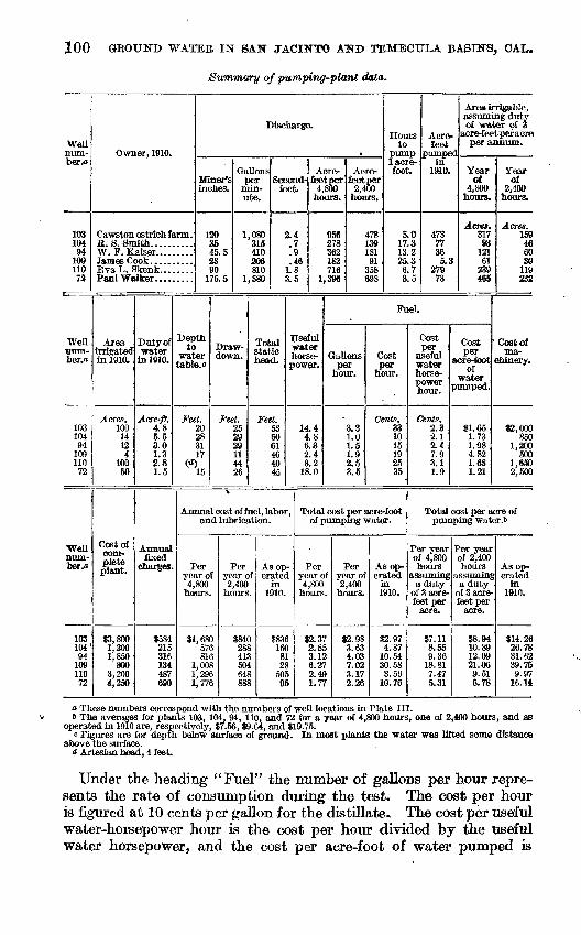
100 GROUND WATER IN SAN JACINTO AND TEMECTJLA BASINS, OAL.
Summary of pumping-plant data.
Wellnum-ber/i
103104
9410911072
Well ntim- ber.o
10310494
109110
72
Wellnum- ber.o
10310494
10911072
Owner, 1910.
Cawston ostrich farm .B. S. Smith..........W. F. Kaiser.........James Cook..........EvaL. Skenk........Paul Walker. ........
Area irrigated in 1910.
Acres.100
14124
10050
Cost ofcom plete plant.
$3,8001,2001,850
8003,2004,250
Duty of water
in 1910.
Acre-ft.4.85.53.01.32.81.5
Annualfixed
charges.
$584215316134487690
Miner's
120IS45, fi33
1
Depth to
water table, c
Feet.20283117
W15
9075 5
Gal
I
Ionsper
m n-ute.
1,
1,
Draw down.
Feet.252929114426
08031541020ft810580
)ischargc
Second-fcset.
2.4
Total static head.
Feet.536061464045
.7
.9
.461.8<? t\O. SJ
>.
Acre-feetpe
4,800hours
95f27J365IK71(
1,39(
.
Acre-r feetper
2,400. hours.
5 478$ 139! 181J 915 3585 698
Useful water horse- Gallons power. per
hour.
14.44.86.3)2.48.2
18.0
Annual cost of fuel, labor,and lubrication.
Peryear of
4,800 hours.
$1 ,6805781
55
1.0081 ,2961,776
Per year oi 2,400
hours.
$840288413504648888
As op erated
in 1910.
$8361618
B1
2850595
.3.31.01.51.92.53.5
Hoursto
pump1 acre-foot.
5.017.313.225.36.73.5
Fuel.
Cost per
hour.
Cents.331015192535
Total cost per acre-footof pumping water.
Peryear of * 4,800
hours.
$2.372.853.126.272.491.77
Perpear of 2,400 lours.
$2.983.634.037.023.172.26
As op erated
in 1910.
$2.97
14,870.54
30.583.56
10.76
Acre-feet
pumpeiin
1910.
47877365.3
27973
Area irrigable,assuming dutyof water of 3
acre-feet per acreper anniim-
1
Yearof
4,800boors.
Acres.31793
12161
239465
Cost per
useful waterhorsepower hour. *
Cente.2.32.12.47.93.11.9
Cost per
acre- tootof
jumped.
$1.651.731.984.821.881.21
Yearof
2,400hours.
Acres.159466030
119232
Cost ofma
chinery.
$2,000850
1,200500
1,6502,500
Total cost per acre of pumping water .6
Per yearof 4,800 hours
assuming a duty
of 3 acre-feet per
acre.
$7.118.559.36
18.817.475.31
Per yearof 2,400 hours
assuming a duty
of 3 acre-feet per
acre.
$8.9410.8912.0921.069.516.78
As op erated
in1910.
$14.2626.7831.6239.759.97
16.14
a These numbers correspond with the numbers of well locations in Plate III.& The averages for plants 103, 104, 94, 110, and 72 for a year of 4,800 hours, one of 2,400 hours, and as
operated in 1910 are, respectively, $7.56, $9.64, and $19.75,c Figures are for depth below surface of ground. In most plants the water was lifted some distance
above the surface.d Artesian head, 4 feet.
Under the heading "Fuel" the number of gallons per hour repre sents the rate of consumption during the test. The cost per hour is figured at 10 cents per gallon for the distillate. The cost per useful water-horsepower hour is the cost per hour divided by the useful water horsepower, and the cost per acre-foot of water pumped is
PUMPING TESTS. 101
equal to the number of hours required to pump 1 acre-foot, multi plied by the cost per hour of fuel.
The annual fixed charges have been taken as 14 per cent of the cost of machinery plus 8 per cent of the cost of the complete plant.
Under the heading "Annual cost of fuel, labor, and lubrication/' the hourly cost is taken as the hourly cost of fuel (given under the heading of fuel), plus 2 cents an hour for labor and lubrication. The number of hours operated in 1910 is obtained by multiplying the number of acre-feet pumped in 1910 by the number of hours required to pump 1 acre-foot.
The total cost per acre-foot of pumping water for 4,800 hours, for 2,400 hours, and for the period of operation in 1910, is for each period equal to the annual cost of fixed charges plus fuel, labor, and lubri cation, divided by the number of acre-feet pumped.
The total cost per acre of pumping water during years of 4,800 and of 2,400 hours is taken as three times the cost per acre-foot, as it is assumed that a fair duty for water in this region is 3 acre-feet per acre. The total cost per acre as operated in 1910 is equal to the total cost per acre-foot of pumping water during that year, multiplied by the duty of water as actually used.
A comparison of the areas irrigable during years of 4,800 and 2,400 hours with the areas irrigated in 1910 shows clearly that the plants were used far less than economy would dictate. This was due in a considerable degree to the fact that the plants were new and full acreage to be served had not been brought under irrigation, but in part to lack of appreciation of the high cost of irrigation by pumped water when the fixed charges are included.
The figures in the column headed "Drawdown" indicate that, except at plant No. 109, the wells were pumped to the limit of their capacity, the pumps being placed at or near the water level. At plant No. 110 there was artesian flow heading 10 feet above the sur face of the ground.
Under "Cost per useful water horsepower hour," under the head ing "Fuel," the figures indicate the comparative efficiency of the plants. Plant No. 109 is the only one not operated with a fair de gree of efficiency. This satisfactory condition was doubtless due in great measure to the fact that most of the plants were new. Com parison of the cost of fuel, labor, and lubrication with the annual fixed charges shows that in 1910 the fixed charges exceeded the opera tion charges at all but two plants (Nos. 103 and 110), whereas opera tion for 4,800 hours would result in fixed charges about one-third of operation charges and would make the cost of pumped water much more nearly proportional to the cost of operation. .
The next to the last column in the table gives the total cost per acre of pumping water for a season of 200 days of 12 hours, with duty of water at 3 acre-feet to the acre, and shows the cost per acre
102 GROUND WATER IN 8A.N JACINTQ AND TEMECTJLA BASINS, OAL.
that could reasonably be expected in the irrigation of alfalfa with distillate at 10 cents a gallon. Barring plant No. 109, whose high cost of operation was due to an old and very inefficient engine, the mean cost per acre is found to be $9.64, or less than half the average cost of $19.75 in 1910. By continuous operation throughout the irrigating season, the cost could be still further reduced to $7.56 per acre with distillate at 10 cents a gallon.
FACTORS AFFECTING COSTS.
In the descriptions of the pumping plants tested attention has been called to specific factors that rendered the plant a relatively expensive source of water supply, but these factors may properly be mentioned again in order to emphasize their effects on the cost of irrigation.
Most of the pumping plants .in San Jacinto Valley were well housed, but at some plants housing is neglected. The rapid depreciation of pumping machinery, as well as of farm machinery of other kinds, if not taken care of, is very real, and depreciation is an important factor hi the cost of water for irrigation obtained from wells.
In 1910 the tendency throughout the valley was to install pumping machinery capable of more work than was required of it. This tendency may have been in part attributable to the sellers of the ma chinery, who of course desired to make large sales, but large plants appear also to have been installed as a matter of convenience in operation. The irrigator finds it easier to run a large pumping unit for a few hours than to accomplish the same amount of irriga tion with a smaller plant requiring perhaps two or three days to supply the same acerage with water, overlooking the fact that the interest on the greater amount of capital invested in the larger plant and the increased amount that must be charged to depreciation form very considerable items in the total annual cost of irrigation. If a larger plant has been installed than is needed to supply the acreage watered the error can be remedied if more land can be furnished with water, and the same result can of course be accomplished either by bringing new land under irrigation or by supplying from one plant lands that have been watered by two or more pumping units, each of which has been operated only a small part of the time.
Although theoretically the pumping system should be only large enough to furnish the necessary amount of water if kept running continuously throughout the irrigating season, practically the lowest limit to the size of plant is approximately fixed by the necessity of pumping a stream large enough to flow through the irrigation ditches with sufficient velocity to permit its proper distribution. The size of stream that must be thrown in order to give proper distribution depends very largely on the character of the soil, however. In
PUMPING TESTS. 103
Sacramento Valley,-in the northern part of the State, it has been found that "a discharge of at least 12 gallons per minute to the acre should if possible be provided for alfalfa on ordinary loam soils in tracts of 40 to 200 acres, with larger capacities for smaller tracts and slightly smaller capacities for larger tracts." 1
At several plants in San Jacinto Valley economy is obtained by the use of small plants pumping into reservoirs from which a suffi cient irrigating head can be obtained during periods of irrigation. This practice has within recent years been encouraged by granting to plants using electric power somewhat lower rates for power used at night.
In connection with the mistake of installing a plant larger than is needed for the area irrigated may be mentioned the installation of a pump whose capacity exceeds that of the well to supply water. The use of such a pump may entail considerable loss in efficiency either from excessive drawdown, which makes the pump lift greater than need be, or from the entrance of air into the pump, whose suction is thereby impaired. This action is of course greatest when the Water level is drawn down to the lower end of the suction pipe; but even if this extreme lowering of the water level does not take place the fairly great velocity of flow into the suction pipe draws in bubbles of air which affect the priming. Such overtaxing can usually be overcome by enlarging the well or by sinking one or more auxiliary wells con nected to the pump intake by tunnels or by suction pipes.
Although pumps in good condition may lift water about 28 feet under suction, a lift of about 20 feet has been found in practice to be the maximum economical limit. Centrifugal pumps and the cylinders of reciprocating piftnps should be placed not higher than this distance above the water level when pumping. Enlargements or bell-mouths on the ends of intake and discharge pipes are found to reduce the friction loss in head at points of entrance and discharge and thus slightly to increase the efficiency. Likewise, the elimina tion of unnecessary elbows and bends in the pipes reduces losses from friction. At some pumping plants the end of the discharge pipe is placed higher than is necessary. Since every foot in height that the water is raised requires a certain amount of work, it is obvious that the discharge point should be only high enough to deliver the water into the ditch.
The running of a large internal combustion engine at less than its load capacity is an important factor in increasing cost of pump ing. Under such conditions, in order to keep down to normal speed, the engine misses a number of explosions each minute. Serious loss in efficiency may thus be occasioned, as brake tests show that under
i Bryan, Kirk, Ground water for irrigation in the Sacramento Valley, CaL: U. S. Geol. Survey Water- Supply Paper 375, p. 38, 1915.
104 GROUND WATER IN SAN JAOINTO AND TEMECTJLA BASINS, CAL.
Buch conditions there is a marked loss in the effective work. This loss is due largely to the fact that the power consumed within the machine in compression of the charge and in friction i& approxi mately constant, and hence as the amount of work produced by the machine is decreased the energy consumed, internally becomes a larger part of the total energy.1 The overloading of an engine, when normal speed may be kept up by feeding an extra amount of fuel, is also uneconomical, because of the excessive consumption of fuel and the strain on the machinery.
Notable variations in speed, either of increase or of decrease beyond the normal, result in inefficient service, for every properly constructed engine is designed to run under conditions of speed and load that are fairly well determined by the size of the engine parts, and any great variation in these conditions is bound to be attended by loss in efficiency from one or more causes. In electric motors underspeeding does not result in notable loss in efficiency, since the internal friction losses are slight and a large part (80*to 90 per cent) of the power consumed is given out as useful work. Overspeeding, however, may necessitate repairs due to overheating or burning out of parts.
The proper adjustment of feed and ignition in an internal-com bustion engine has great influence on the efficient working of the machine. If the ignition is retarded too much, an excessive charge of fuel is required. By advancing the spark, therefore, to produce a certain amount of pre-ignition, the consumption of fuel may be appreciably reduced.
The temperature of the jacket water is a factor that is too often overlooked, for if the cylinder is cooled too much, the ignition may lag, and the same effect will be produced as by a spark too far retarded.
At many plants too little attention is paid to the proper oiling and adjustment of the various bearings. Injury, of course, may quickly result to them from overheating due to lack of oil, or to running too tight; whereas if too much play is allowed the engine will be injured by pounding. Slipping of a loose belt is often the cause of poor service, whereas too tight a belt produces an undue strain on the pulley bearings.
For proper running of a pump, relations of load and speed similar to those in an engine must be taken into consideration. Improper speeding of a centrifugal or other form of rotary pump will cause loss in efficiency, because if underspeeded the runner will not impart an economic proportion of its velocity to the water and therefore the pump will not lift water to its full capacity; and if overspeeded the runner will churn or will produce excessive velocity in the stream
i Le Conte, J. N., and Tait, C. E., Mechanical tests of pumping plants in California: IT. S. Dept. Agr. Office Exper. Sta. Bull. 181, p. 72,1907.

FUMFESTG TESTS, 105
of water and losses due to excessive friction in the intake and outlet pipes. Although a centrifugal pump throws more water when some what overspeeded, it requires much more power for a given discharge than does a larger pump run at the proper speed. As has been pre viously mentioned, overspeeding may also cause marked drop in efficiency by drawing air into the pump and impairing its suction. Orerspeeding is, however, less to be avoided than underspeeding, since the discharge drops rapidly with slower rotation.
For each rotary pump there is a definite relation between the lift of the water and the speed of the pump for greatest efficiency. The proper speed for each lift is usually given by the pump maker and should be closely adhered to in order to obtain satisfactory results both in the amount of water lifted and in. economy of power.
In reciprocating pumps underspeeding may unduly diminish the discharge through failure of the valves to open and dose promptly; overspeeding often results in the breaking of sucker rods or the loos ening of pump foundations and the consequent throwing out of alignment and increase in losses due to friction.
The proper size and speed for the pump will be determined by the amount of water to be discharged and the lift. The engine or motor should then be adapted in size to give the necessary power. By means of the proper sized pulleys or gears the suitable working speed for both pump and prime mover can be obtained.
SELECTION OF MACHINERY.
The most common errors in the selection of machinery are (1) the purchase of a pump too large for the capacity of the well, necessi tating operation at a low, uneconomical speed and generally, also, excessive suction lift; and (2) too low an estimate of total head, with consequent purchase of an engine with insufficient power. It is fortunate that these errors, when occurring together, are to a certain degree compensating. The net result is frequently an engine suited to the head and capacity of the well, but a pump too large for engine and for well capacity, a condition that does not, however, greatly increase the cost of the plant.
The rancher usually depends largely on a pump or engine dealer or manufacturer for the design of his plant, and furnishes the dealer with certain data which are often given without a very clear idea of what is required or of the importance of accuracy. Furthermore, the rancher seldom has a very definite idea of the relative cost of irrigation with plants of different sizes. The proper size of prime mover and pump for given lifts and discharge are given in some manufacturers' catalogues or will be supplied by the service depart ments of the firms. Consultation with these departments will often prevent costly mistakes in the installation of a plant. The following
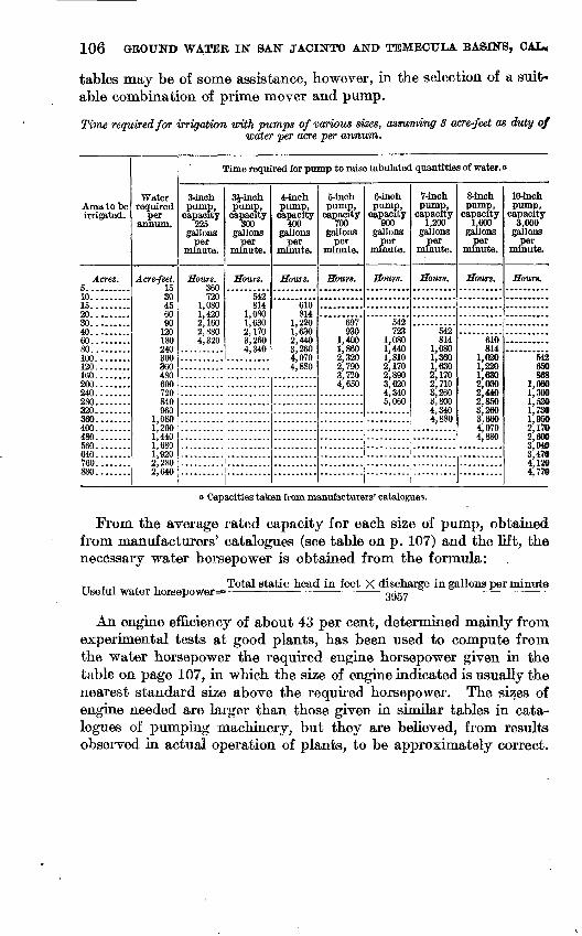
106 GROUND WATER IN SAN JACINTO AND TEMECULA BASINS, CAL,
tables may be of some assistance, however, in the selection of a suit able combination of prime mover and pump.
Time required for irrigation with pumps of various sizes, assuming 3 acre-feet as duty ofwater per acre per annum.
Area to be irrigated.
Acres. 5..........10.........15.........20.........3n4060.........80.........100........120........160......:.200........240........280........320........360........400........480560........640........760........880........
Water required
per annum.
Acre-feet. 15 30 45 60 90
120 180 240 300 360 480 600 720 840 960
1,0801,2001 4401,6801,9202,280 2,640
Time required for pump to raise tabulated quantities of water, o
3-inch pump,
capacity225
gallons per
minute.
Hours. 360 720
1,080 1,420 2,160 2,880. 4,320
3Hnch pump,
capacity 1500
gallons per
minute.
Hours.
542 814
1,080 1,630 2,170 3,260 4,340
ii
! "
4-inch pump,
capacity 400
gallons per
minute.
Hours.
eio814
1,220 1,630 2,440 3,260 4,070 4,880
5-inch pump,
capacity
gallons per
minute.
Hours.
697 930
1,400 1,860 2,320 2,790 3,720 4,650
6-inch pump,
capacity 900
gallons per
minute.
Hours.
542 723
1,080 1,440 1,810 2,170 2,890 3,620 4,340 5,060
7-inch pump,
capacity 1,200
gallons per
minute.
Hours.
542 814
1,080 1,360 1,630 2,170 2,710 3,260 3,800 4,340 4,880
..........- |-~ -------
i
8-inch pump,
capacity 1,600
gallons per
minute.
Hours.
610 814
1,020 1,220 1,630 2,030 2,440 2,850 3,260 3,660 4,070 4,880
10-inch pump,
capacity 3,000
gallons per
minute.
Hours.
542 650 868
1,080 1,300 1,520 1,730 1,950 2,170 2,600 3,040 3,470 4,120 4,770
a Capacities taken from manufacturers' catalogues.
From the average rated capacity for each size of pump, obtained from manufacturers' catalogues (see table on p. 107) and the lift, the necessary water horsepower is obtained from the formula:
Useful water horsep<ywer=Total static head in feet X discharge in gallons per minute
3957
An engine efficiency of about 43 per cent, determined mainly from experimental tests at good plants, has been used to compute from the water horsepower the required engine horsepower given in the table on page 107, in which the size of engine indicated is usually the nearest standard size above the required horsepower. The sizes of engine needed are larger than those given in similar tables in cata logues of pumping machinery, but they are believed, from results observed in actual operation of plants, to be approximately correct.
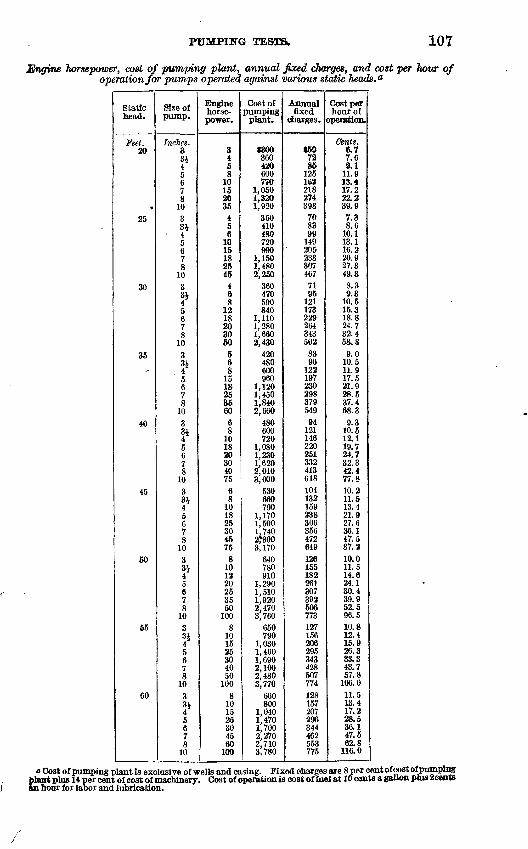
PUMPHSTG 107
Engine horsepower, cost of pumping plant, annual faced charges, and cost per hour of operation for pumps operated against various static heads. 0
Static head.
Feet.20
4
25
30
35^
40
45
50
55
60
Size of pump.
Inches.33J4567S
1033i
- 45678
103314*
5678
1033i?5678
10331?5678
1033J4567 8
10301
?5678
1033J45678
103Ql
?5678
10
Engine horse power.
3458
10152035
456
1015182545
468
1218203060
568
1518253560
68
101820304075
68
101825304575
8101220253550
1008
101525304050
1008
101525304560
100
Cost of pumping
plant.
$300360420600770
1,0501,3201,920
350410480720990
1,1501,4802,250
360470590840
1,1101,2801,6602,430
420480600960
1,1201,4501,8402,660
480600720
1,0801,2301,6202,0103,000
530660790
1,1701,5001,740 273003,170
640780910
1,2901,5101,9202,4703,760
650790
1,0301,4601,6902,1002,4803,770
660800
1,0401,4701,7002,2702,7103,780
Annualfixed
charges.
$597285
125162218274398708399
149205238307467
7195
121173229264343502
8396
12219723029837954994
121146220251332413618104132159238306356 472649126155182261307392506773127156206295343428507774128157207296344462553775
Cost per hour of
operation.
Cents.6.77.69.1
11.913.417.222.239.97.38.6
10.113.116.220.927.349.38.39.3
10.515.318.824.732.45S.S9.0
10.511.917.521.928.537.468.39.3
10.512.119.724.732.342.477.810.211.513.421.927.636.147.587.210.011.514.624.130.439.952.596.510.812.415.926.333.343.757.8
106.011.513.417.228.536.147.562.8
116.0
o Cost of pumping plant is exclusive of wells and casing. Fixed charges are 8 per cent of cost oipumptng plant plus 14 per cent of cost of machinery. Cost of operation is cost of fuel at 10 cents a gallon ptas Scents ftn bour for labor and lubrication.
108 GROUND WATEK IN SAN JACINTO AND TEMEOULA BASINS, CAL*
The cost of pumping plant includes only the cost of engine, pump and fittings, and the housing. As the cost of engine and pump varies somewhat according to the make, and the cost of housing varies with the style of building used, the three items have been combined into the averages presented. The prices for the machinery, however, are average list prices for distillate engines and centrifugal pumps of the indicate*! sizes. The cost of housing is based on actual examples and is taken as about $50 for the smaller plants, the cost for larger plants increasing by about 10 per cent of the addi tional cost of the machinery. No attempt has been made to deter mine the average cost of well and casing, since these costs are so variable that averages would be of no special significance. In some places the cost of the completed well is relatively small; in others it may equal the cost of the remainder of the plant.
The annual fixed charges have been computed as 8 per cent of the cost of pumping plant plus 14 per cent of the estimated cost of engine and pump alone.
The cost per hour of operation is based on the probable amount of distillate, at 10 cents per gallon, used per hour, plus 2 cents per hour of operation for labor and lubrication. The duty of distillate is taken, as the result of numerous tests, at one-eighth gallon per hour per horsepower developed. In the table this is of course not the same as the horsepower "size" of the engine, which is adapted only approximately to the actual power required. The hourly consump tion of distillate for each combination of pump and lift can be determined, if desired, from the last column by subtracting the cost of labor and lubrication (2 cents) and dividing by 10 (the assumed price in cents per gallon). For example, in a plant of the size indi cated in the first line of the table, the computed consumption of
/> t-J __ Q
distillate is \ Q or 0.47 gallrfn per hour. From this figure other
calculations based on different costs of distillate per gallon can be made.Example: It is desired to irrigate by pumping a tract of 80 acres
of land to be set in alfalfa. In consideration of rainfall, evaporation, and other climatic conditions, the area should be flooded during the irrigation season with sufficient water to cover the land to a depth of 3 feet (equivalent to flooding 6 inches in depth six times during the season). The depth to water in neighboring wells is about 20 feet, and it is desired to raise the water 5 feet above the surface of the ground at the proposed pumping plant. The length of the irrigating season is about 200 days.
Referring to the table on page 107, opposite 80 in the first column, we find that a 3^-inch pump will require 4,340 hours, or 21.7 hours a day, for 200 days to supply the desired amount of irrigation water; a 4-inoh pump will require 3,260 hours, or 16.3 hours a day, for 200 days; a 5-inch pump will require 1,860 hours, or 9.3 hours a day for 200 days;
TB8X&. 109
& 6-iach pump wiJl mquire 1,440 tours, or 7.2 hours a day for 200 days. Now, the depth to the water being 20 feet and the lift above the surface of the ground 5 feet, a head of 25 feet must be provided for in addition to the suction lift. Hie suction lift should be taken at 25 feet unless it is known that & well of great capacity can be obtained. The total static head, therefore, in this case will be 50 feet. In the table on page 107, opposite 50 in the cokcam for static head, the follow ing information can be found:
(a) S^-inch pump; 10-horsepower engine; cost with, housing,Fixed charges.......................................... $155Operation, 4,340 hours, at 11.5 cents per hour............ 499
Total yearly cost <rf pumping........................ 654Yearly cost per acre......................................... 8.18
(6) 4-inch pump; 12-horsepoww engine; cost with hcrasing, $910.Fixed charges.......................................... $182Operation, 3,260 hours, at 14.-6 cents per hour .......... 476
Total yearly cost of pumping...................... 658Yearly cost per acre..................................... 8.22
(c) 5-inch, pump; 20-horsepower engine 1; cost with, housing, fl, 290.Fixed charges..........___..___.................... $261Operation, 1,860 hours, at 24.1 cents per hour............ 448
Total yearly east of pumping................ .... 709Yearlycost per acre...._.. . ..._.. .......... 8.86
(ff) 6-inch pump; 25-horsepower engine; eost with housing, $1,510.Fixed charges.......................................... $307Operation, 1,440 TMHMB, &t30,4cents per hour............ 438
Total yearly cost of pumping...................... 745Yearly cost per acre.................................... 9.31
{«) 7-inch pump; 35-h.orsepo1»er engine; coat with, ioramng, $1,920.Fixed charges..................._.................. $392Operation, 1,080 houre, at 39.9 cents per hour............ 431
Total yearly cost of pumping...................... 823Yearly cost per acre................................... 10.29
It appears from these figures that the total cost of pumping increases gradually with the size of plant used. This is because the larger plants lie idle a proportionately greater time, while interest, taxes, de preciation and other fixed charges accumulate. With the foregoing information in mind, the rancher can proceed to have a well, or wefls, bored with some definite idea of the sort of plant he will need. The bor ing, digging, or drilling of wells in such manner as to obtain the great est flow of water at least eost is a matter subject to wide variation in procedure in accordance with local conditions. Let it be assumed that a well is bored and the test x shows a, flow of 300 gallons a minute with a lowering of 15 feet in the water surface. Such a well will sup ply a Si-inch pump with a suction lift of 15 feet (assuming the pump to be placed at the water surface), or a 4-inch pump with a suction lift
i Every well Should "be carefully tested "by pumping and its flow measured before a pumping plant is purchased. Only in this way can ibe plan* pwcSased be adapted to tbe flow obtainable from -wells.
110 GROUND WATER IN SAN JACINTO AND TEMECULA BASINS, OAL.
of about 20 feet, but will not supply a larger pump. With this well, therefore, the choice is narrowed down to plants a and &. It is now possible to revise the estimates because, instead of a suction lift of 25 feet, as previously assumed, it is known that the lift will be about 15 feet for plant a, or 20 feet for plant &. The total static heads will be 40 feet and 45 feet, respectively. From the table on page 107 the following revised estimates are derived:
a-1. 40-foot head, 3^-inch pump, 8-horsepower engine, cost withhousing, $600:
Fixed charges........................................ $121Operation, 4,340 hours, at 10.5 cents per hour.......... 456
Total yearly cost of pumping.................... 577Yearly cost per acre................................... 7.21
6-1. 45-foot head, 4-inch pump, 10-horsepower engine, cost withhousing, $790:
Fixed charges........................................ 159Operation, 3,260 hours, at 13.4 cents per hour.............. 437
Total yearly cost of pumping.................... 596Yearly cost per acre................................... 7.45
It is seen that plant 5-1 costs $190 more than plant a-1 and that the yearly cost of pumping will be $19 greater. In view of the lesser time required for pumping, the larger plant would probably be chosen by most ranchers, but with the foregoing study of the problem, the choice could be made intelligently with clear knowledge as to what the added convenience of the larger plant will cost. If a still larger plant were, for any reason, considered desirable additional wells would be required.
Any engine or pump of standard make can be selected with the assurance that it will do satisfactory work if properly operated, due regard being paid to the general principle that machinery costing least is worth least.
In San Jacinto Valley the distillate engine with vertical centrifugal pump set at the water level will generally prove satisfactory. In those parts of the valley where the water level is close to the surface or where there are flowing wells, the capacity of the wells seems to be comparatively small, and it may be advisable to sink the pump pit and install the pump considerably below the ground-water level.
Steam plants for irrigation, except in large units, are generally unsatisfactory. Where 75 horsepower or more is required, gas pro ducers using crude oil for fuel, together with producer-gas engines, probably furnish the cheapest power obtainable. Such plants are not economical in small units.
Deep-well pumps are much more costly than centrifugal pumps, but are more efficient. Centrifugal pumps are better suited to present conditions in the valley, but if the water level should be generally lowered as the number and use of pumping plants continues, deep-well pumps would become desirable in several places.
INDEX.
Page. Agriculture in San Jacfnto VaUey............ 14
in the Temecula basin ................ 84-85See also Irrigation, employment of.
Alessandro, well near, depth to water in..... 53Alessandro irrigation district, water supplied
to............................... 19.Alessandro Valley, depth to water in........ 48
from point north of Perris, plate showing. 36 irrigation in............................. 62location of............................... 50
Alfalfa, raising of......................... 14,15,85See also Irrigation, employment of.
Alkali, presence of.......................... 13-14,31-32,37,41,47,64,69,78-79,81,90,93
Analyses of ground waters........... 25,48, insertsfacing 30,36,40,62,78,86
Artesian wells, areas of.... 21,27-29,42-44,87-88,91flow of.................................. 27-29logs of................................... 26,27
Babcpek, Edward S., analyses by........... 48Babtiste Valley, depth to ground water in... 92 Badlands, rocks of........................... 9Bench lands below Lee Lake, plate showing. 78
below Temescal, plate showing.......... 78Boiler use, quality of waters for......... 23-23,31,
37,41,47,63,78,81, inserts feeing 30, 36, 40,62, 78, 86
Bowers, wells Nos. 125 and 126 at, water levelin............................... 28-29
Brownlands, artesianwaterin............... 43lake in.................................. 42
Bundy's Elsinore Hot Spring, description of. 75
Caliche, deposit of........................... 65California, map of part of, showing areas cov
ered by water-supply papers..... 7Cantarini, Auguste, wells of................. 87-88Casa Loma, logs of wells near................ 42-43Cawston ostrich farm, test of pumping plant
on.............................. 94,100Cienaga east of San Jacinto, water from...... 31Citizens Water Co., operations of......... 18-19,30Classification of ground waters........ 23-23,31,37,
41,47,50,63,69, 78,81,89-90,93,inserts facing 30,36,40,62,78,86
Clay, occurrence of....................... 15-16,79Climate of the San Jacinto basin............ 10-14
of the Temecula basin................... 84Coal, occurrence of........................... 15,79Cook, James, test of pumping plant of... 95-96,100 Corona, irrigation at......................... 62-63
Diamond Valley, grain growing in........... 36run-off from............................. 37
Dinsmore, S. C., analyses by..... inserts facing 30,36,40,62,78
Page. Domenigoni Valley, alkaliin............_. 41
limitsand drainage of................... 38welkin.................................. 41
Domestic use, quality of waters for......... 22,31,37,41,47,63,69,78,81,89-90,93, inserts facing 30,36,40,62,78,86
Double Bntte, western part of, plate showing. 38
Earthquake of 1899, limits of................. 9Eden Hot Spring, description of............. 24
plate showing........................... 21Egan, well near, depth to water in........... 33,35Elsinore, precipitation at................. 11,12,13
San Jacinto Eivernear.................. 72-74Temescal Creek near..................... 74
Elsinore Lake, escarpment along south sideof, plate showing................ 68
history of................................ 71-72log of flowing wellnear.................. 76
Elsinore Lake area, alkaliin.............. 78-79geologic features of...... ....../.. 70-71hot springs in................... 75irrigation in....................... 76-78level of ground water in.............. 75-76limits and surface of.............. 60quality of ground waterin............... 78southern part of, plate showing....... 70surface waterin......................... 71-74
Ethan A. Chase Co., operations of........ 62Ethanae, well near, depth to water in....... 89
Fair view Land & Water Co., operations of... 18 Faults bounding San Jacinto basin, descrip
tion of........................... 9Field work, record of........................ 7Fruit trees,citrus, growing of............ 14
See also Irrigation, employment of. deciduous, growing of.................... 14,84See also Irrigation, employment of.
Gas, occurrence of........................... 43Geography of San Jacinto basin............. 7-9
of the Temecula basin................... 81-82Geology of San Jacinto basin................ 9-H)
of the Temecula basin................... 82-83Glen Ivy Hot Springs, description of........ 79-80Grain, raising of.......................... 14,84,85
See also Irrigation, employment of.
Hemet, wells near, depth to water in.... 34,35Hemet area, ground-water level in....... 32-36
irrigation in............................. 36-37limits and soil of............ -. 32quality of water in............. 37
Hemet irrigated district from Reservoir Butte,plate showing................ 36
Hemet irrigation works, construction of. 15
in
112 INDEX.
Page. Hemet Land Co., operations of.............. 17-18Hot springs in the San Jaeinto basin, descrip
tion of........................... 24-25of the Pilares, location and water of...... 43-44
Idyllwild, precipitation at................... 10,11Indian Creek, warm sulphur springs on...... 25Irrigation, employment of... 30-31,36-37,41,46-47,
50,62-63,68-69,76-78,80-81,89,92-93quality of waters for..................... 22,
31,37,41,47,50,63,69,78,81,89-90,93, inserts facing 30,36,40,62,78,86. systems for.............................. 16-19
Juniper Flat, Lakeview Mountains, plateshowing......................... 38
soil of................................... 38
Kaiser, W. F., test of pumping plant of..... 95,100
Lake Hemet Water Co., operations of....... 16-18Lakeview, wells at and near, depth to water
in............................... 44-46Lakeview area, alkali in..................... 47
artesian wells in......................... 42-44gas in................................... 43irrigation in............................. 46-47level of ground water in................. 44-46quality of water in.. 47, insert facing 40. surface and soils......................... 42warm springs in......................... 43-44
Lakeview Water Co., operations of.......... 19Land, irrigated, maps showing......... In pocket.
prepared for seeding, plate showing..... 51Lee Lake, water in and under............... 80Level of ground water.... 29-30,32-36,44-46,48-50,
51-62,65-68,75-76,80,88-89,92 Lucerne, log of well near.................... 70Lucerne district, water supply of............ 77
Maas, Arthur R., analysis by................Magnesite, occurrence of.....................Menifee area, alkali in.......................
irrigation in.............................level of ground water in.................limits and drainage of...................quality of ground water in..............soils of..................................
Menifee School, wells near, depth to water in.. Mill Creek, water for irrigation from.........Mining, attempts at.........................Moreno area, irrigation in....................
logs of wells in...........................level of ground water in.................quality of water in.. 50, insert facing 40.surface and soil of.......................
Mountains of Temecula basin, elevations of.. Murrieta Creek, course and tributaries of....Muirieta Valley, alkali in....................
artesian area in..........................extent and agriculture of................hot springs in............................irrigation in.............................level of ground water in.................quality of ground water in...............
251669
68-6965-68
64 69 65
66-68 50
15-16 50
48-5048-50
47-48 82 85 90
87-8886-87
87
Nigger Canyon, dam site in.
Paloma Valley, irrigation in................. 68-69location of............................... 64
Perris, wells at or near, depth to water in... 54-58,59-61
Perris area, irrigation in..................... 62-63level of ground water in................. 51-62limits and soil of......................... 50-51quality of ground water in............... 63
Perris irrigation district, water supplied to.. 19Perris Valley from point north of Perris, plate
showing......................... 36Precipitation in the San Jaeinto basin....... 10-13
in the Temecula basin.............. .... 84Pumping, cost of, factors affecting......... 102-105
selection of machinery for.............. 105-110Pumping plants, tests of.................... 93-110
untested, estimated capacity and expensesof................................ 97
Pumps, horsepower and cost of............ 106-110time required for irrigation with......... 106
Quality of ground water................. 21-23,31,37,41,47,50,63,69,78,81,89-90,93
Railroad in San Jaeinto Valley.............. 14Relief Hot Springs, description of............ 24Ritchey Hot Springs, description of......... 25
Salt Creek, course of......................... 64San Jaeinto, precipitation at.............. 11,12,13San Jaeinto area, alkali in................... 31-32
artesian area in.......................... 27-29extent of................................ 23-24hot springs in............................ 24-25irrigation in............................. 30-31level of ground water in................. 29-30quality of ground water in............... 31
San Jaeinto basin, extent of................. 20map of, showing depth to water and loca
tion of wells................ In pocket.showing irrigated lands and principal
distribution systems....... In pocket.showing lands irrigated in 1904 and in
1915........................ In pocket.showing relief and drainage basins... 8
San Jaeinto Hot Springs, description of...... 24San Jaeinto River, channel and flow of........ 42,51
description of............................ 8-9near Elsinore............................ 72-74near Perris, plate showing............... 51valley of,from Park Hill, plate showing.. 30
from Relief Hot Springs, plate show ing. ............................. 24
San Jaeinto Water Co., operations of........ 18San Luis Rey River, discharge of............ 86Schanck, Francis R., cited.................. 71Schuyler, J. D., cited........................ 17Skenk, Mrs. Eva L., test of pumping plant of. 96,100 Smith, R. S., test of pumping plant of....... 94,100Soboba Hot Springs, description of.......... 25Source of ground water...................... 20-21Spreading of flood water..................... 62Springs, hot, at Elsinore, description of....... 75
hot, near Temescal, description of....... 79warm, in the Lakeview area, description
of............................... 43
INDEX. 113
r, Herman, pumping tests............ 93-110Stone, quarrying of....'...................... 16Storage of flood water underground, methods
of............................... 62
Temecula basin, climate of.................. 84geography of............................ 81-82geology of............................... 82-83map of, showing depth to water and loca
tion of wells.................... In pocket.showing irrigated land and principal
distribution systems....... In pocket.showing relief and drainage basins... 8
settlement and industries of............. 84-85surface water in......................... 85-86
Temecula Canyon, dam site in............... 86Temecula River, course and flow of....:..... 85-86
valley of, plate showing.................. 70Temecula Valley, alkali in.................. 93
artesian area in.......................... 91irrigation in............................. 92-93level of ground water in................. 92limits of................................. 90quality of ground water in............... 93
71065° 19 WSP 429 8
Temescal area, alkali in...................... 81hot springs in............................ 79-80irrigation in............................. 80-81level of ground water in................. 80limits and soil of......................... 79quality of ground water in............... 81
Temescal Creek near Elsinore................ 74Temescal Wash, course of.................... 79
plate showing........................... 78Temescal Water Co., operations of........... 62-63
pumping station of...................... 97-98Towns in San Jacinto Valley................. 14-15
in the Temecula basin................... 84
Vegetation, nature of......................... 13
Walker, Paul, test of pumping plant of.. 96-97,100 Wells, logs of, plate showing................. 32Winchester, wells at and near, depth to water
in............................... 39-40Winchester area, alkali in.................... 41
irrigation in............................. 41level of ground water in................. 38-40limits and soil of......................... 37-38quality of ground water in............... 41
ADDITIONAL COPIESOF THIS PtTBUCATION MAT BE PROCURED FROM
THE SUPERINTENDENT OF DOCUMENTSGOVERNMENT PRINTING OFFICE
WASHINGTON, D. C.
AT
40 CENTS PER COPY