ground penetrating radar survey
TRANSCRIPT
GROUND-PENETRATING
RADAR SURVEY BANTEAY CHHMAR, CAMBODIA.
For the Global Heritage Fund
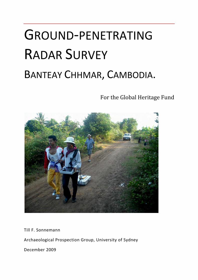
Till F. Sonnemann
Archaeological Prospection Group, University of Sydney
December 2009
Archaeological Prospection Group - University of Sydney
Ground-penetrating Radar Survey – Banteay Chhmar
2
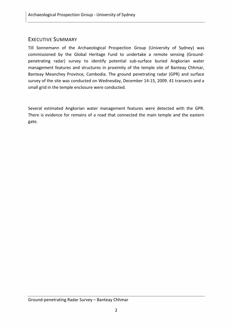
EXECUTIVE SUMMARY
Till Sonnemann of the Archaeological Prospection Group (University of Sydney) was
commissioned by the Global Heritage Fund to undertake a remote sensing (Ground-
penetrating radar) survey to identify potential sub-surface buried Angkorian water
management features and structures in proximity of the temple site of Banteay Chhmar,
Banteay Meanchey Province, Cambodia. The ground penetrating radar (GPR) and surface
survey of the site was conducted on Wednesday, December 14-15, 2009. 41 transects and a
small grid in the temple enclosure were conducted.
Several estimated Angkorian water management features were detected with the GPR.
There is evidence for remains of a road that connected the main temple and the eastern
gate.
Archaeological Prospection Group - University of Sydney
Ground-penetrating Radar Survey – Banteay Chhmar
3
CONTENTS
Executive Summary .................................................................................................................... 2
Contents ..................................................................................................................................... 3
List of Figures ............................................................................................................................. 4
Background Information ............................................................................................................ 5
Study Area .................................................................................................................................. 5
Ground Penetrating Radar ......................................................................................................... 6
Results and Interpretation ......................................................................................................... 7
Area A1: connection between the temple structure and the gate ........................................... 7
Area A2, A3 and A4: The Baray ................................................................................................ 13
Area A5 and A6: Channels ........................................................................................................ 19
Summary .................................................................................................................................. 26
Further Survey.......................................................................................................................... 26
References ............................................................................................................................... 27
Acknowledgements .................................................................................................................. 27
Contact ..................................................................................................................................... 27
Appendix: Anomalies ............................................................................................................... 28
Archaeological Prospection Group - University of Sydney
Ground-penetrating Radar Survey – Banteay Chhmar
4
LIST OF FIGURES
Figure 1: Overview of Banteay Chhmar with areas where GPR profiles were conducted. .................... 5
Figure 2: Area A1 – GPR-Profiles east of the temple ............................................................................. 7
Figure 3: Profiles BC_DAT_0001 (S->N) and BC_DAT_0002 (N->S) east of the moat within A1. ........ 8
Figure 4: Profile BC_DAT_0003 (E->W) over the moat. ......................................................................... 8
Figure 5: GPR-profiles BC_DAT_0004 - BC_DAT_0007. ...................................................................... 9
Figure 6: GPR- Profiles BC_DAT_0008 – BC_DAT_00011 ................................................................. 10
Figure 7: Setting up the grid west of the temple. Time slice A7 (Depth: 0.66-0.78 m). ........................ 11
Figure 8: GPR-Grid time slices of the unfinished Grid. ......................................................................... 12
Figure 9: Area A2. Profiles BC_DAT_0012 – BC_DAT_0021 .............................................................. 13
Figure 10: BC_DAT_0012 (W-E), BC_DAT_0014 (E-W), BC_DAT_0014 (W-E) South of embankment. .............................................................................................................................................................. 14
Figure 11: Road on the southern baray embankment. ......................................................................... 14
Figure 12: DAT_0015 (E->W) DAT_0016 (E->W), ). In the baray. ...................................................... 15
Figure 13: GPR-Profiles BC_DAT_0017 (W->E), BC_DAT_0018 (W->E), BC_DAT_0019 (E->W), BC_DAT_0020 (W->E) BC_DAT_0021 (E->W). On top of the embankment. ...................................... 16
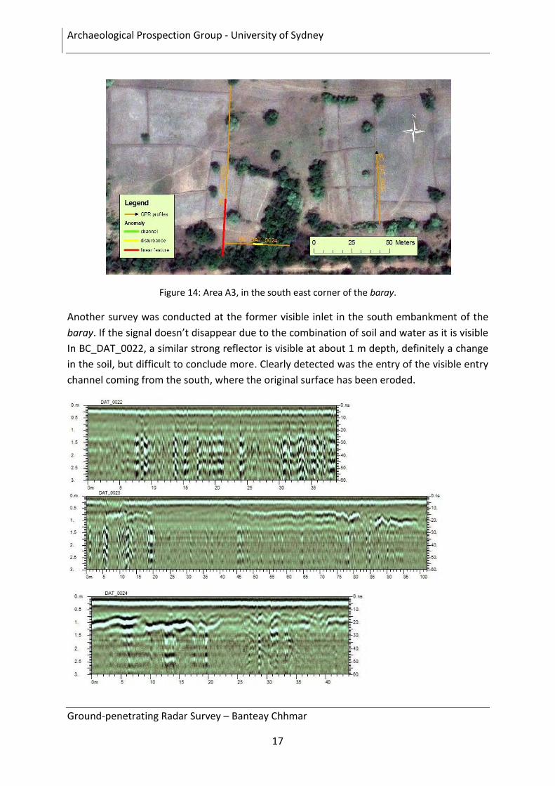
Figure 14: Area A3, in the south east corner of the baray. ................................................................... 17
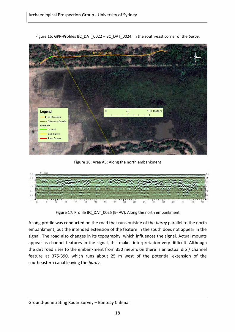
Figure 15: GPR-Profiles BC_DAT_0022 – BC_DAT_0024. In the south-east corner of the baray. ..... 18
Figure 16: Area A5: Along the north embankment ............................................................................... 18
Figure 17: Profile BC_DAT_0025 (E->W). Along the north embankment ............................................ 18
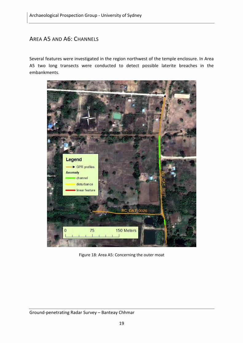
Figure 18: Area A5: Concerning the outer moat ................................................................................... 19
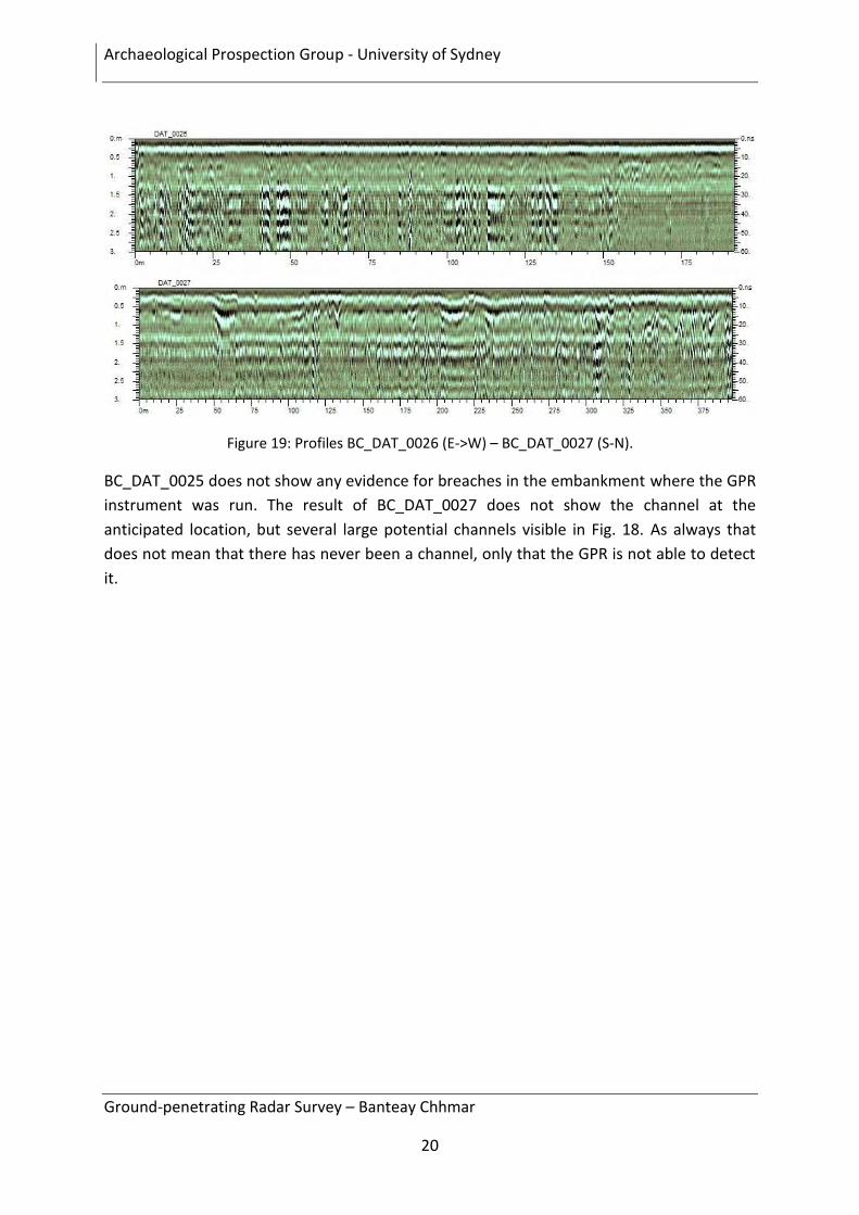
Figure 19: Profiles BC_DAT_0026 (E->W) – BC_DAT_0027 (S-N). .................................................... 20
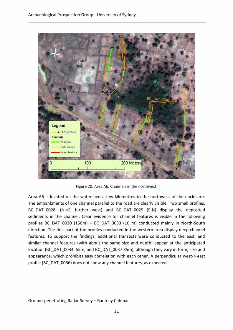
Figure 20: Area A6: Channels in the northwest. ................................................................................... 21
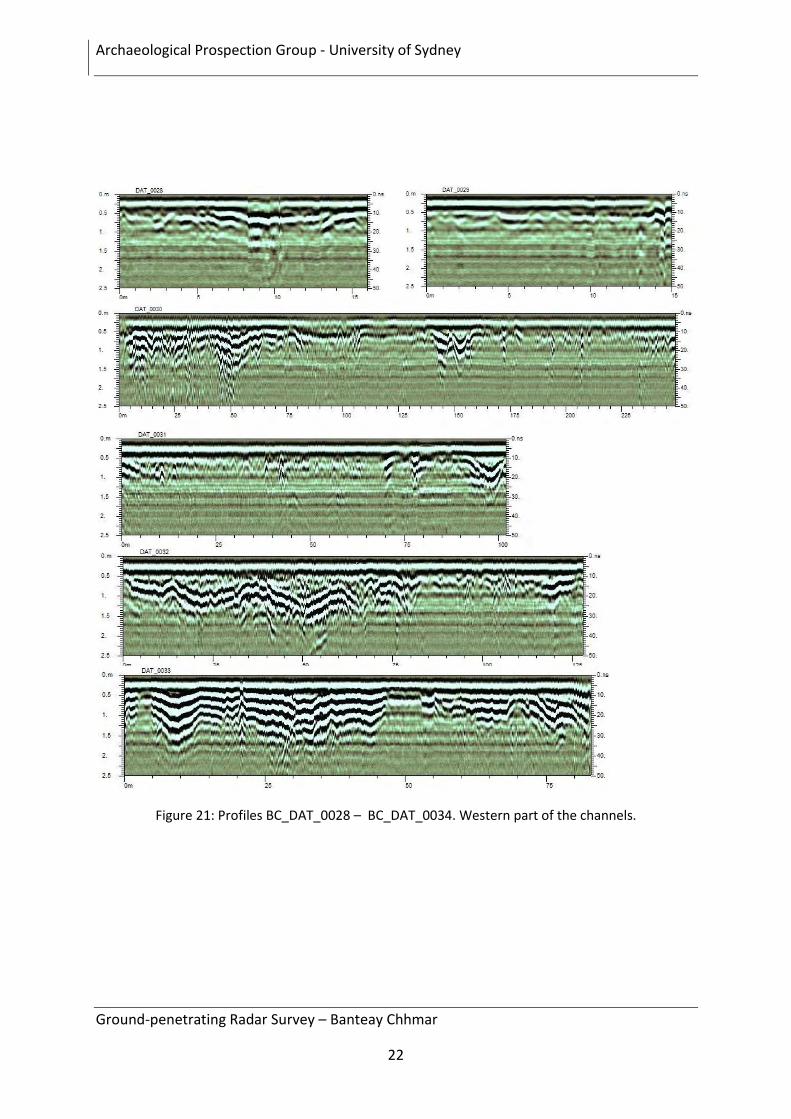
Figure 21: Profiles BC_DAT_0028 – BC_DAT_0034. Western part of the channels. ......................... 22
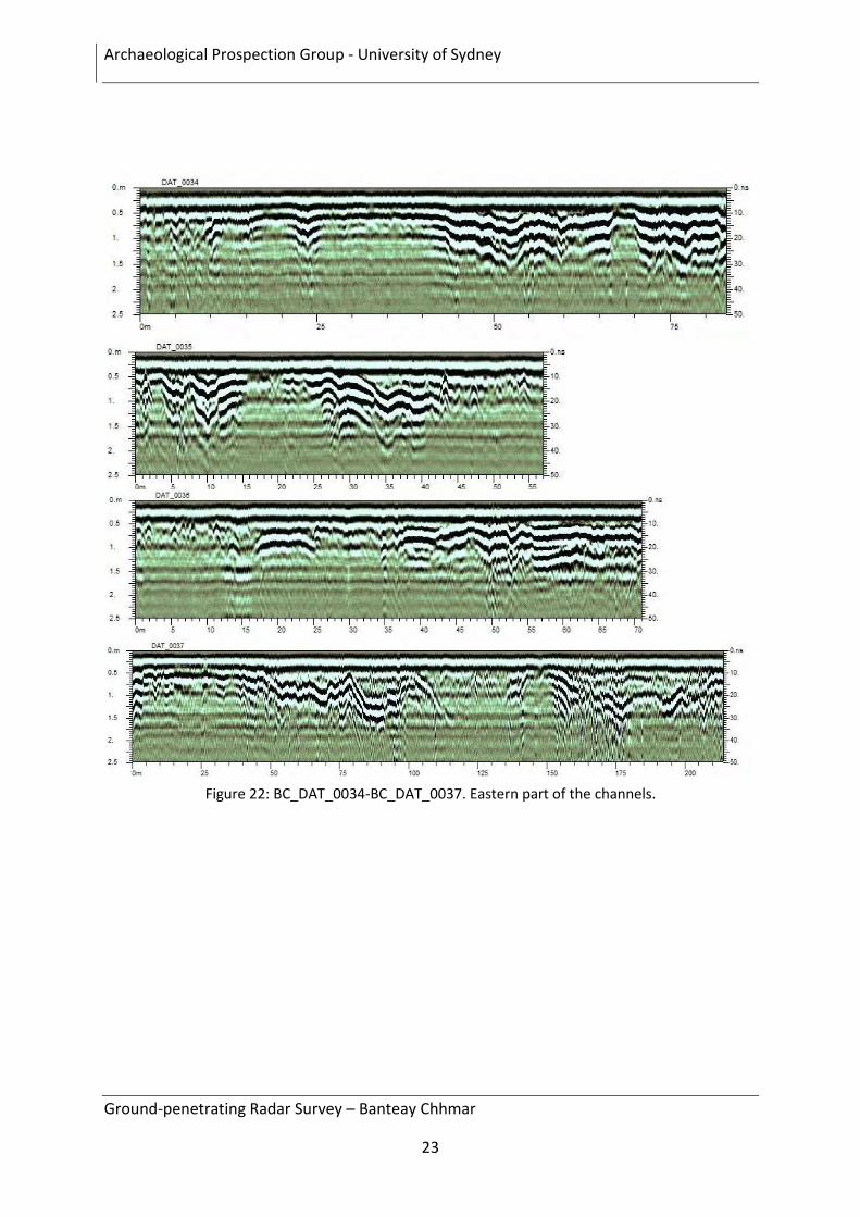
Figure 22: BC_DAT_0034-BC_DAT_0037. Eastern part of the channels. ........................................... 23
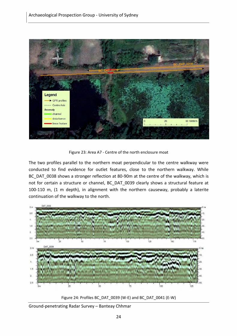
Figure 23: Area A7 - Centre of the north enclosure moat ..................................................................... 24
Figure 24: Profiles BC_DAT_0039 (W-E) and BC_DAT_0041 (E-W) .................................................. 24
Figure 25: Area A8: Northeast corner of the enclosure moat. .............................................................. 25
Figure 26: Profiles BC_DAT_0040 (W-E) and BC_DAT_0041 (N-S) ................................................... 25
Archaeological Prospection Group - University of Sydney
Ground-penetrating Radar Survey – Banteay Chhmar
5
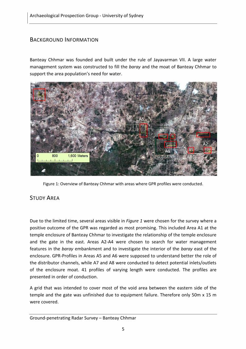
BACKGROUND INFORMATION
Banteay Chhmar was founded and built under the rule of Jayavarman VII. A large water
management system was constructed to fill the baray and the moat of Banteay Chhmar to
support the area population’s need for water.
Figure 1: Overview of Banteay Chhmar with areas where GPR profiles were conducted.
STUDY AREA
Due to the limited time, several areas visible in Figure 1 were chosen for the survey where a
positive outcome of the GPR was regarded as most promising. This included Area A1 at the
temple enclosure of Banteay Chhmar to investigate the relationship of the temple enclosure
and the gate in the east. Areas A2-A4 were chosen to search for water management
features in the baray embankment and to investigate the interior of the baray east of the
enclosure. GPR-Profiles in Areas A5 and A6 were supposed to understand better the role of
the distributor channels, while A7 and A8 were conducted to detect potential inlets/outlets
of the enclosure moat. 41 profiles of varying length were conducted. The profiles are
presented in order of conduction.
A grid that was intended to cover most of the void area between the eastern side of the
temple and the gate was unfinished due to equipment failure. Therefore only 50m x 15 m
were covered.
Archaeological Prospection Group - University of Sydney
Ground-penetrating Radar Survey – Banteay Chhmar
6
GROUND PENETRATING RADAR
Ground Penetrating Radar (GPR) is a non-destructive and non-invasive geophysical survey
method widely used in archaeological prospection to locate and indicate the depth of
subsurface features, such as building foundations, buried structures, graves and service
lines. Ground Penetrating Radar works on the basis of VHF pulses being directed into the
earth’s surface.
The GPR instrument consists of an antenna and a processing unit. The antenna slides over
the ground sending every few centimetres an electromagnetic signal into the subsurface.
Whenever the signal hits a layer or an object of different electromagnetic character than the
layer above, part of the signal is reflected and sent back (Snell’s law). The signal is received
by a second antenna and the time elapsed (travel time) is measured in nanoseconds [ns],
while the velocity for electromagnetic signals is displayed in meters/ nanoseconds [m/ns].
The sum of all transmitted signals of one survey line is called radargram. With knowledge of
the composition of the subsurface (i.e. dry concrete, dry sand ~ 0.15 [m/ns], wet sand ~
0.055 [m/ns]) the travel time can be translated into depth of the object from which the
signal has been reflected, which allows the creation of an electromagnetic image of the
subsurface. Knowledge from excavations in the Angkor area is the only possible information
about the true depth of features, it is assumed in this study that 10ns is about 0.6 – 0.8
metres depth. Tree roots and strong electrical/magnetic fields such as from power lines can
also influence results.
The depths and resolution of the survey depends on the ground composition and the
antenna type used. For archaeological prospection a frequency range of 250-500 MHz
antenna is normally used. For this survey a 250 MHz shielded antenna on a Mala X3M GPR
system was utilized.
To survey an area a grid is set up, and the GPR is run over in parallel lines with a spacing of
usually 0.5 m, a process similar to lawn mowing, to cover the total area. Grids have to be a
certain size to make the results interpretable (should not be smaller than 5 m by 5 m), so
the goal is to make the grids as large as possible with minimum obstacles in the path of the
GPR. Using the travel time/depth information, computer programs can take the data from
each line in the grid and produce a travel time—and therefore depth—dependent three-
dimensional map of the area. The map can be viewed as horizontal slices, layer by layer
defined by the depth, known as time-slices. For the current survey all data was post-
processed using GPR Slice imaging software.
Archaeological Prospection Group - University of Sydney
Ground-penetrating Radar Survey – Banteay Chhmar
7
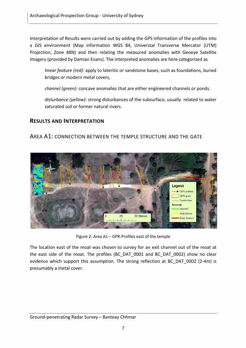
Interpretation of Results were carried out by adding the GPS information of the profiles into
a GIS environment (Map information WGS 84, Universtal Transverse Mercator (UTM)
Projection, Zone 48N) and then relating the measured anomalies with Geoeye Satellite
Imagery (provided by Damian Evans). The interpreted anomalies are here categorized as
linear feature (red): apply to lateritic or sandstone bases, such as foundations, buried
bridges or modern metal covers,
channel (green): concave anomalies that are either engineered channels or ponds.
disturbance (yellow): strong disturbances of the subsurface, usually related to water
saturated soil or former natural rivers.
RESULTS AND INTERPRETATION
AREA A1: CONNECTION BETWEEN THE TEMPLE STRUCTURE AND THE GATE
Figure 2: Area A1 – GPR-Profiles east of the temple
The location east of the moat was chosen to survey for an exit channel out of the moat at
the east side of the moat. The profiles (BC_DAT_0001 and BC_DAT_0002) show no clear
evidence which support this assumption. The strong reflection at BC_DAT_0002 (2-4m) is
presumably a metal cover.
Archaeological Prospection Group - University of Sydney
Ground-penetrating Radar Survey – Banteay Chhmar
8
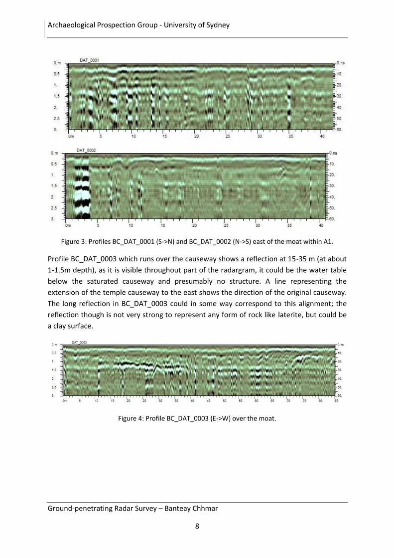
Figure 3: Profiles BC_DAT_0001 (S->N) and BC_DAT_0002 (N->S) east of the moat within A1.
Profile BC_DAT_0003 which runs over the causeway shows a reflection at 15-35 m (at about
1-1.5m depth), as it is visible throughout part of the radargram, it could be the water table
below the saturated causeway and presumably no structure. A line representing the
extension of the temple causeway to the east shows the direction of the original causeway.
The long reflection in BC_DAT_0003 could in some way correspond to this alignment; the
reflection though is not very strong to represent any form of rock like laterite, but could be
a clay surface.
Figure 4: Profile BC_DAT_0003 (E->W) over the moat.
Archaeological Prospection Group - University of Sydney
Ground-penetrating Radar Survey – Banteay Chhmar
9
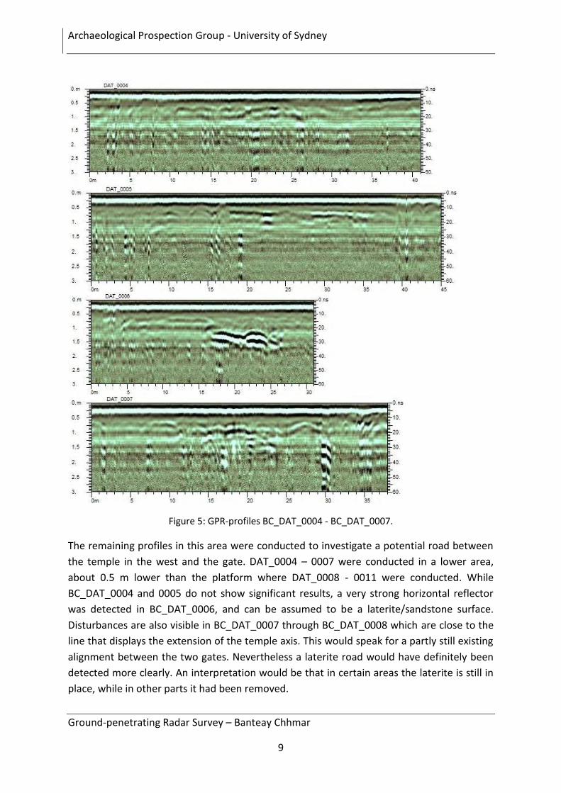
Figure 5: GPR-profiles BC_DAT_0004 - BC_DAT_0007.
The remaining profiles in this area were conducted to investigate a potential road between
the temple in the west and the gate. DAT_0004 – 0007 were conducted in a lower area,
about 0.5 m lower than the platform where DAT_0008 - 0011 were conducted. While
BC_DAT_0004 and 0005 do not show significant results, a very strong horizontal reflector
was detected in BC_DAT_0006, and can be assumed to be a laterite/sandstone surface.
Disturbances are also visible in BC_DAT_0007 through BC_DAT_0008 which are close to the
line that displays the extension of the temple axis. This would speak for a partly still existing
alignment between the two gates. Nevertheless a laterite road would have definitely been
detected more clearly. An interpretation would be that in certain areas the laterite is still in
place, while in other parts it had been removed.
Archaeological Prospection Group - University of Sydney
Ground-penetrating Radar Survey – Banteay Chhmar
10
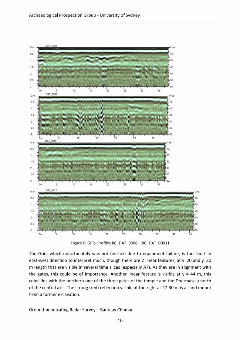
Figure 6: GPR- Profiles BC_DAT_0008 – BC_DAT_00011
The Grid, which unfortunately was not finished due to equipment failure, is too short in
east-west direction to interpret much, though there are 2 linear features, at y=20 and y=30
m length that are visible in several time slices (especially A7). As they are in alignment with
the gates, this could be of importance. Another linear feature is visible at y = 44 m, this
coincides with the northern one of the three gates of the temple and the Dharmasala north
of the central axis. The strong (red) reflection visible at the right at 27-30 m is a sand mount
from a former excavation.
Archaeological Prospection Group - University of Sydney
Ground-penetrating Radar Survey – Banteay Chhmar
11
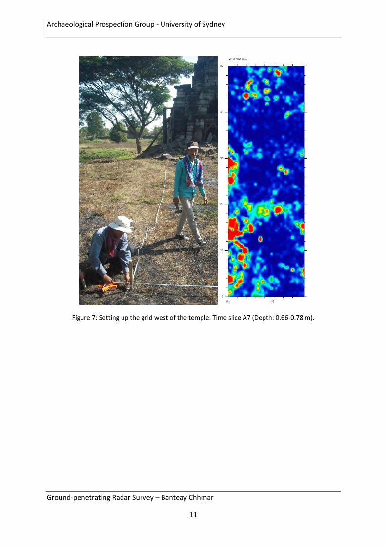
Figure 7: Setting up the grid west of the temple. Time slice A7 (Depth: 0.66-0.78 m).
Archaeological Prospection Group - University of Sydney
Ground-penetrating Radar Survey – Banteay Chhmar
12
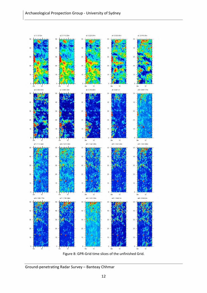
Figure 8: GPR-Grid time slices of the unfinished Grid.
Archaeological Prospection Group - University of Sydney
Ground-penetrating Radar Survey – Banteay Chhmar
13
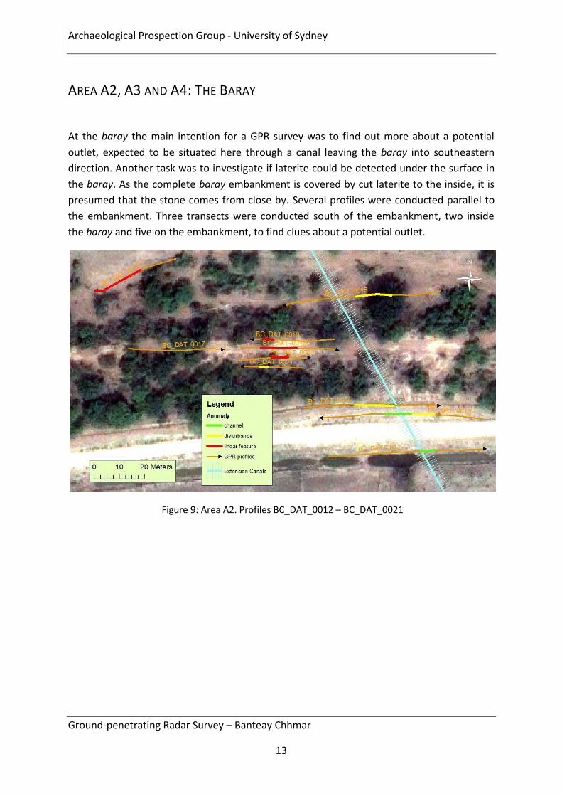
AREA A2, A3 AND A4: THE BARAY
At the baray the main intention for a GPR survey was to find out more about a potential
outlet, expected to be situated here through a canal leaving the baray into southeastern
direction. Another task was to investigate if laterite could be detected under the surface in
the baray. As the complete baray embankment is covered by cut laterite to the inside, it is
presumed that the stone comes from close by. Several profiles were conducted parallel to
the embankment. Three transects were conducted south of the embankment, two inside
the baray and five on the embankment, to find clues about a potential outlet.
Figure 9: Area A2. Profiles BC_DAT_0012 – BC_DAT_0021
Archaeological Prospection Group - University of Sydney
Ground-penetrating Radar Survey – Banteay Chhmar
14
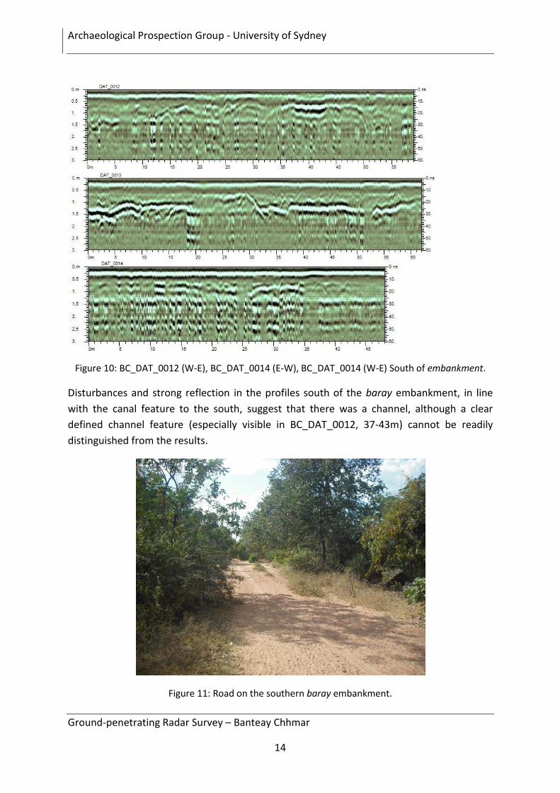
Figure 10: BC_DAT_0012 (W-E), BC_DAT_0014 (E-W), BC_DAT_0014 (W-E) South of embankment.
Disturbances and strong reflection in the profiles south of the baray embankment, in line
with the canal feature to the south, suggest that there was a channel, although a clear
defined channel feature (especially visible in BC_DAT_0012, 37-43m) cannot be readily
distinguished from the results.
Figure 11: Road on the southern baray embankment.
Archaeological Prospection Group - University of Sydney
Ground-penetrating Radar Survey – Banteay Chhmar
15
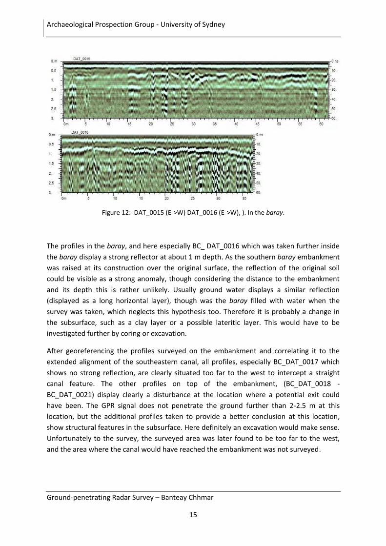
Figure 12: DAT_0015 (E->W) DAT_0016 (E->W), ). In the baray.
The profiles in the baray, and here especially BC_ DAT_0016 which was taken further inside
the baray display a strong reflector at about 1 m depth. As the southern baray embankment
was raised at its construction over the original surface, the reflection of the original soil
could be visible as a strong anomaly, though considering the distance to the embankment
and its depth this is rather unlikely. Usually ground water displays a similar reflection
(displayed as a long horizontal layer), though was the baray filled with water when the
survey was taken, which neglects this hypothesis too. Therefore it is probably a change in
the subsurface, such as a clay layer or a possible lateritic layer. This would have to be
investigated further by coring or excavation.
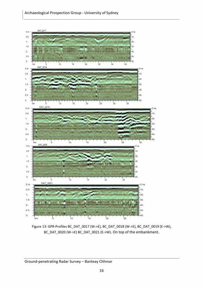
After georeferencing the profiles surveyed on the embankment and correlating it to the
extended alignment of the southeastern canal, all profiles, especially BC_DAT_0017 which
shows no strong reflection, are clearly situated too far to the west to intercept a straight
canal feature. The other profiles on top of the embankment, (BC_DAT_0018 -
BC_DAT_0021) display clearly a disturbance at the location where a potential exit could
have been. The GPR signal does not penetrate the ground further than 2-2.5 m at this
location, but the additional profiles taken to provide a better conclusion at this location,
show structural features in the subsurface. Here definitely an excavation would make sense.
Unfortunately to the survey, the surveyed area was later found to be too far to the west,
and the area where the canal would have reached the embankment was not surveyed.
Archaeological Prospection Group - University of Sydney
Ground-penetrating Radar Survey – Banteay Chhmar
16
Figure 13: GPR-Profiles BC_DAT_0017 (W->E), BC_DAT_0018 (W->E), BC_DAT_0019 (E->W),
BC_DAT_0020 (W->E) BC_DAT_0021 (E->W). On top of the embankment.
Archaeological Prospection Group - University of Sydney
Ground-penetrating Radar Survey – Banteay Chhmar
17
Figure 14: Area A3, in the south east corner of the baray.
Another survey was conducted at the former visible inlet in the south embankment of the
baray. If the signal doesn’t disappear due to the combination of soil and water as it is visible
In BC_DAT_0022, a similar strong reflector is visible at about 1 m depth, definitely a change
in the soil, but difficult to conclude more. Clearly detected was the entry of the visible entry
channel coming from the south, where the original surface has been eroded.
Archaeological Prospection Group - University of Sydney
Ground-penetrating Radar Survey – Banteay Chhmar
18
Figure 15: GPR-Profiles BC_DAT_0022 – BC_DAT_0024. In the south-east corner of the baray.
Figure 16: Area A5: Along the north embankment
Figure 17: Profile BC_DAT_0025 (E->W). Along the north embankment
A long profile was conducted on the road that runs outside of the baray parallel to the north
embankment, but the intended extension of the feature in the south does not appear in the
signal. The road also changes in its topography, which influences the signal. Actual mounts
appear as channel features in the signal, this makes interpretation very difficult. Although
the dirt road rises to the embankment from 350 meters on there is an actual dip / channel
feature at 375-390, which runs about 25 m west of the potential extension of the
southeastern canal leaving the baray.
Archaeological Prospection Group - University of Sydney
Ground-penetrating Radar Survey – Banteay Chhmar
19
AREA A5 AND A6: CHANNELS
Several features were investigated in the region northwest of the temple enclosure. In Area
A5 two long transects were conducted to detect possible laterite breaches in the
embankments.
Figure 18: Area A5: Concerning the outer moat
Archaeological Prospection Group - University of Sydney
Ground-penetrating Radar Survey – Banteay Chhmar
20
Figure 19: Profiles BC_DAT_0026 (E->W) – BC_DAT_0027 (S-N).
BC_DAT_0025 does not show any evidence for breaches in the embankment where the GPR
instrument was run. The result of BC_DAT_0027 does not show the channel at the
anticipated location, but several large potential channels visible in Fig. 18. As always that
does not mean that there has never been a channel, only that the GPR is not able to detect
it.
Archaeological Prospection Group - University of Sydney
Ground-penetrating Radar Survey – Banteay Chhmar
21
Figure 20: Area A6: Channels in the northwest.
Area A6 is located on the watershed a few kilometres to the northwest of the enclosure.
The embankments of one channel parallel to the road are clearly visible. Two small profiles,
BC_DAT_0028, (N->S, further west) and BC_DAT_0029 (S-N) display the deposited
sediments in the channel. Clear evidence for channel features is visible in the following
profiles BC_DAT_0030 (150m) – BC_DAT_0033 (10 m) conducted mainly in North-South
direction. The first part of the profiles conducted in the western area display deep channel
features. To support the findings, additional transects were conducted to the east, and
similar channel features (with about the same size and depth) appear at the anticipated
location (BC_DAT_0034, 55m, and BC_DAT_0037 85m), although they vary in form, size and
appearance, which prohibits easy correlation with each other. A perpendicular west-> east
profile (BC_DAT_0036) does not show any channel features, as expected.
Archaeological Prospection Group - University of Sydney
Ground-penetrating Radar Survey – Banteay Chhmar
22
Figure 21: Profiles BC_DAT_0028 – BC_DAT_0034. Western part of the channels.
Archaeological Prospection Group - University of Sydney
Ground-penetrating Radar Survey – Banteay Chhmar
23
Figure 22: BC_DAT_0034-BC_DAT_0037. Eastern part of the channels.
Archaeological Prospection Group - University of Sydney
Ground-penetrating Radar Survey – Banteay Chhmar
24
Figure 23: Area A7 - Centre of the north enclosure moat
The two profiles parallel to the northern moat perpendicular to the centre walkway were
conducted to find evidence for outlet features, close to the northern walkway. While
BC_DAT_0038 shows a stronger reflection at 80-90m at the centre of the walkway, which is
not for certain a structure or channel, BC_DAT_0039 clearly shows a structural feature at
100-110 m, (1 m depth), in alignment with the northern causeway, probably a laterite
continuation of the walkway to the north.
Figure 24: Profiles BC_DAT_0039 (W-E) and BC_DAT_0041 (E-W)
Archaeological Prospection Group - University of Sydney
Ground-penetrating Radar Survey – Banteay Chhmar
25
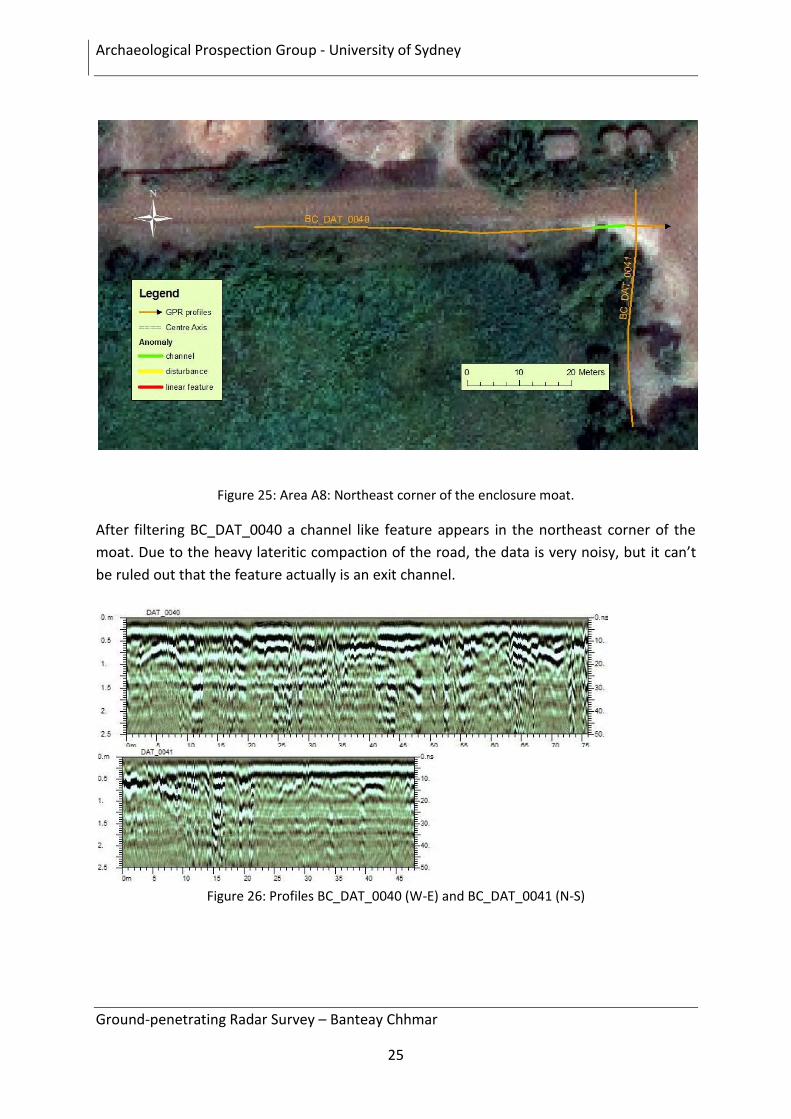
Figure 25: Area A8: Northeast corner of the enclosure moat.
After filtering BC_DAT_0040 a channel like feature appears in the northeast corner of the
moat. Due to the heavy lateritic compaction of the road, the data is very noisy, but it can’t
be ruled out that the feature actually is an exit channel.
Figure 26: Profiles BC_DAT_0040 (W-E) and BC_DAT_0041 (N-S)
Archaeological Prospection Group - University of Sydney
Ground-penetrating Radar Survey – Banteay Chhmar
26
SUMMARY
As Ground-penetrating Radar was able to detect several features that were predicted from
aerial images or due to symmetrical reason, it clearly shows the advantages of using
geophysical methods at Banteay Chhmar. If no evidence was found this still does not mean
that there is no structure /channel. The conclusion here can only be that the instrument has
not detected it.
FURTHER SURVEY
Different geophysical methods, such as small scale seismic or resistivity to better
understand the subsurface in the baray, or excavations, especially in areas where features
were detected will certainly give new clues and improve the understanding of the water
management system at Banteay Chhmar. Nevertheless can any Geophysical method not
provide the same detailed information which would be received from an archaeological
excavation.
Archaeological Prospection Group - University of Sydney
Ground-penetrating Radar Survey – Banteay Chhmar
27
REFERENCES
Bevan, B W. 1996 Seeing Beneath the Soil: Prospecting Methods in Archaeology. London:
Routledge.
Bevan, B. W. 2006 Geophysical exploration for buried buildings. Historical Archaeology 40:
27-50.
Conyers, L. B. 2004 Ground-Penetrating Radar for Archaeology. Walnut Creek, California:
AltaMira Press.
Conyers, L. B. and D. Goodman 1997 Ground-Penetrating Radar: An Introduction for
Archaeologists. Walnut Creek, California: Alta Mira Press.
Gaffney, C., and J. Gater 2003 Revealing the Buried Past: Geophysics for Archaeologists.
Stroud, Great Britain: Tempus Publishing.
ACKNOWLEDGEMENTS
I would like to thank my two assistants Mr. Chenda and Mr. Nanh for their great help,
Damian Evans for providing the satellite data and background information and especially
James Goodman and the Global Heritage Fund for their kind hospitality and help to conduct
the survey.
The GPR survey was financially supported by the Global Heritage Fund.
CONTACT
Till F. Sonnemann
Dipl. Geophys. & PhD student
Department of Archaeology
University of Sydney, NSW 2006
E-mail: [email protected], [email protected]
Website: http://acl.arts.usyd.edu.au/apg/
Archaeological Prospection Group - University of Sydney
Ground-penetrating Radar Survey – Banteay Chhmar
28
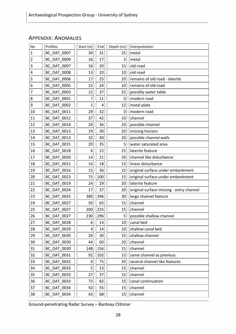
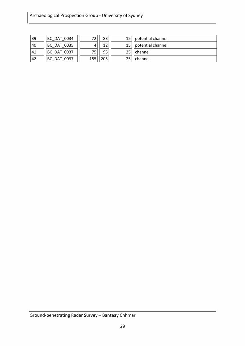
APPENDIX: ANOMALIES
No Profiles Start (m) End Depth (ns) Interpretation:
1 BC_DAT_0007 30 31 25 metal
2 BC_DAT_0009 16 17 5 metal
3 BC_DAT_0007 16 20 15 old road
4 BC_DAT_0008 13 20 10 old road
5 BC_DAT_0006 17 25 20 remains of old road - laterite
6 BC_DAT_0005 22 24 10 remains of old road
7 BC_DAT_0003 15 37 25 possibly water table
8 BC_DAT_0001 7 11 0 modern road
9 BC_DAT_0002 1 4 12 metal plate
10 BC_DAT_0011 29 32 0 modern road
11 BC_DAT_0012 37 42 10 channel
12 BC_DAT_0014 20 36 20 possible channel
13 BC_DAT_0013 19 30 20 missing horizon
14 BC_DAT_0013 32 40 20 possible channel walls
15 BC_DAT_0015 20 35 5 water saturated area
16 BC_DAT_0018 6 22 25 laterite feature
17 BC_DAT_0020 14 21 20 channel like disturbance
18 BC_DAT_0021 14 18 15 linear disturbance
19 BC_DAT_0016 15 36 15 original surface under embankment
20 BC_DAT_0023 75 100 15 original surface under embankment
21 BC_DAT_0019 24 29 20 laterite feature
22 BC_DAT_0024 17 27 20 original surface missing - entry channel
23 BC_DAT_0025 380 396 30 large channel feature
24 BC_DAT_0027 50 65 15 channel
25 BC_DAT_0027 200 225 15 channel
26 BC_DAT_0027 230 296 5 possible shallow channel
27 BC_DAT_0028 6 14 10 canal bed
28 BC_DAT_0029 4 14 10 shallow canal bed
29 BC_DAT_0030 20 30 15 shallow channel
30 BC_DAT_0030 44 60 20 channel
31 BC_DAT_0030 148 156 15 channel
32 BC_DAT_0031 92 102 15 same channel as previous
33 BC_DAT_0032 0 75 20 several channel like features
34 BC_DAT_0033 5 13 15 channel
35 BC_DAT_0033 27 37 15 channel
36 BC_DAT_0033 73 82 15 canal continuation
37 BC_DAT_0034 50 55 15 channel
38 BC_DAT_0034 43 68 15 channel
Archaeological Prospection Group - University of Sydney
Ground-penetrating Radar Survey – Banteay Chhmar
29
39 BC_DAT_0034 72 83 15 potential channel
40 BC_DAT_0035 4 12 15 potential channel
41 BC_DAT_0037 75 95 25 channel
42 BC_DAT_0037 155 205 25 channel