ground penetrating radar mapping in rescue … · 12th international conference on ground...
TRANSCRIPT
12th International Conference on Ground Penetrating Radar, June 16-19, 2008, Birmingham, UK
Ground Penetrating Radar Mapping in Rescue Archaeology. A Study from Pego Late Bronze Age Settlement, Braga (NW
Portugal) Luís Gonçalves1, Hugo Aluai Sampaio2, M. Isabel Caetano Alves3, and Ana M. S. Bettencourt4
1,3NCT and 2,4CITCEM, University of Minho Braga, Portugal
email: [email protected], [email protected], [email protected], [email protected]
Abstract - Rescue archaeology, sometimes called preventive or salvage archaeology, is archaeological survey and excavation carried out in areas threatened by, or revealed by, construc-tion or other development. Unlike traditional survey and ex-cavation, these works must be undertaken in the shortest pos-sible time. In these scenarios the use of ground penetrating radar (GPR) allows field archaeologists to quickly discover and map buried archaeological features. This paper describes the use of GPR during a rescue archaeology campaign at the Pego Late Bronze Age settlement, near the city of Braga (NW Portugal). Closely spaced GPR transects were collected in a grid-based approach, covering three different areas from the site, using GSSI Sir 3000 System, with antennae frequency of 400MHz. Wave velocities were determined by reflected wave and Hy-perbola-Fitting methods. Measured velocities ranged between 0.12-0.14 m/ns. Amplitude slice-maps of the surveyed grids were produced. The interpretation of these maps indicates the existence of several cultural features from Bronze Age (post holes, pits, small trenches and flat graves) at an approximated depth of 50 cm. The information obtained with this GPR survey proved to be very useful. Amplitude slice-maps produced act as primary data that is going to be used to guide the rescue archaeological excavation. These results are significant because they can pro-vide a template for interpretation of future GPR surveys of Late Bronze Age sites in NW Portugal and even in NW Iberia.
Keywords – Rescue Archaeology, GPR, Bronze Age.
I. INTRODUCTION Archaeologists have employed ground-penetrating radar (GPR) for discovery and mapping buried archaeological sites for many decades, often with good success [2]. Its utility to not only find, but project information from limited test excavations into a large area in tree-dimensions is un-disputed, and can be a method to readily discover and map historic and prehistoric remains [3].
When facing a scenario of rescue archaeology time is the key issue, as, unlike traditional survey and excavation, these works must be undertaken in the shortest possible time. In this scenario the rapid and reliable mapping that can be accomplished with GPR use is essential to delineate and implement excavation strategies, which will maximize
the record of valuable information from the archaeological site before it’s destruction.
In NW Portugal most of Bronze Age archaeological sites have been recently revealed in construction areas, particu-larly during the opening of new roads and highways and in the construction of new residential zones. Due to the scar-city of information from Bronze Age in this region, these sites are of extreme importance, however the time to study them is limited as the developments must carry on.
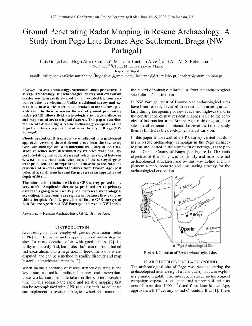
In this paper it is described a GPR survey carried out dur-ing a rescue archaeology campaign in the Pego archaeo-logical site located in the Northwest of Portugal, at the par-ish of Cunha, County of Braga (see Figure 1). The main objective of this study was to identify and map potential archaeological structures, and by this way define and im-plement a more accurate and time saving strategy for the archaeological excavation.
Figure 1. Location of Pego archaeological site.
II. ARCHAEOLOGICAL BACKGROUND The archaeological site of Pego was revealed during the archaeological monitoring of a sand quarry that was explor-ing granitic regolith. The subsequent rescue archaeological campaigns exposed a settlement and a necropolis with an area of more than 1000 m2 dated from Late Bronze Age, approximately 8th century to mid 6th century B.C. [1]. These
12th International Conference on Ground Penetrating Radar, June 16-19, 2008, Birmingham, UK
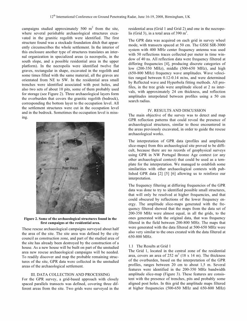
campaigns studied approximately 500 m2 from the site, where several perishable archaeological structures exca-vated in the granitic regolith were identified. The first structure found was a stockade foundation ditch that appar-ently circumscribes the whole settlement. In the interior of this enclosure another type of structures translates an inter-nal organization in specialized areas (a necropolis, in the south slope, and a possible residential area in the upper platform). In the necropolis were identified twelve flat graves, rectangular in shape, excavated in the regolith and some times filled with the same material, all the graves are orientated from NE to SW. In the residential area small trenches were identified associated with post holes, and also two sets of about 10 pits, some of them probably used for storage (see Figure 2). Three archaeological layers form the overburden that covers the granitic regolith (bedrock), corresponding the bottom layer to the occupation level. All the settlement structures were cut in the occupation level and in the bedrock. Sometimes the occupation level is miss-ing.
Figure 2. Some of the archaeological structures found in the
first campaigns at the residential area. These rescue archaeological campaigns surveyed about half the area of the site. The site area was defined by the city council as construction zone, and part of the studied area of the site has already been destroyed by the construction of a house. As a new house will be built on part of the unstudied area new rescue archaeological campaigns will be needed. To readily discover and map the probable remaining struc-tures of the site, GPR data were collected in the unstudied areas of the archaeological settlement.
III. DATA COLLECTION AND PROCESSING For the GPR survey, a grid-based approach with closely spaced parallels transects was defined, covering three dif-ferent areas from the site. Two grids were surveyed in the
residential area (Grid 1 and Grid 2) and one in the necropo-lis (Grid 3), in a total area of 390 m2.
The GPR data was acquired on each grid in survey wheel mode, with transects spaced at 50 cm. The GSSI SIR-3000 system with 400 MHz center frequency antenna was used with 50 reflections traces collected per meter in time win-dow of 40 ns. All reflection data were frequency filtered at differing frequencies [4], producing discrete categories of low (200-350 MHz), middle (500-650 MHz), and high (650-800 MHz) frequency wave amplitudes. Wave veloci-ties ranged between 0.12-0.14 m/ns, and were determined by Reflected wave and Hyperbola fitting methods. All pro-files, in the tree grids were amplitude sliced at 2 ns inter-vals, with approximately 24 cm thickness, and reflection amplitudes interpolated between profiles using a 50 cm search radius.
IV. RESULTS AND DISCUSSION The main objective of the survey was to detect and map GPR reflection patterns that could reveal the presence of archaeological structures, similar to those encountered in the areas previously excavated, in order to guide the rescue archaeological works.
The interpretation of GPR data (profiles and amplitude slice-maps) from this archaeological site proved to be diffi-cult, because there are no records of geophysical surveys using GPR in NW Portugal Bronze Age context (or any other archaeological context) that could be used as a tem-plate for the interpretation. We managed to establish some similarities with other archaeological contexts with pub-lished GPR data [2] [5] [6] allowing us to reinforce our interpretation.
The frequency filtering at differing frequencies of the GPR data was done to try to identified possible small structures, that will only be resolved at higher frequencies, and that could obscured by reflections of the lower frequency en-ergy. The amplitude slice-maps generated with the fre-quency filtered showed that the maps from the data set of 200-350 MHz were almost equal, in all the grids, to the ones generated with the original data, that was frequency filtered in the field between 200-800 MHz. The maps that were generated with the data filtered at 500-650 MHz were also very similar to the ones created with the data filtered at 650-800 MHz.
1.1 The Results at Grid 1 The Grid 1, located in the central zone of the residential area, covers an area of 252 m2 (18 x 14 m). The thickness of the overburden, based on the interpretation of the GPR profiles, ranges between 20 cm to about 1,5 m. Several features were identified in the 200-350 MHz bandwidth amplitude slice-map (Figure 3). These features are consis-tent with the presence of trenches, pits and probably some aligned post holes. In this grid the amplitude maps filtered at higher frequencies (500-650 MHz and 650-800 MHz)
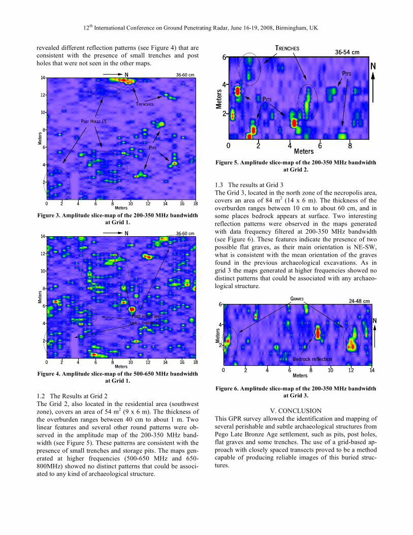
12th International Conference on Ground Penetrating Radar, June 16-19, 2008, Birmingham, UK
revealed different reflection patterns (see Figure 4) that are consistent with the presence of small trenches and post holes that were not seen in the other maps.
Figure 3. Amplitude slice-map of the 200-350 MHz bandwidth at Grid 1.
Figure 4. Amplitude slice-map of the 500-650 MHz bandwidth
at Grid 1.
1.2 The Results at Grid 2 The Grid 2, also located in the residential area (southwest zone), covers an area of 54 m2 (9 x 6 m). The thickness of the overburden ranges between 40 cm to about 1 m. Two linear features and several other round patterns were ob-served in the amplitude map of the 200-350 MHz band-width (see Figure 5). These patterns are consistent with the presence of small trenches and storage pits. The maps gen-erated at higher frequencies (500-650 MHz and 650-800MHz) showed no distinct patterns that could be associ-ated to any kind of archaeological structure.
Figure 5. Amplitude slice-map of the 200-350 MHz bandwidth
at Grid 2.
1.3 The results at Grid 3 The Grid 3, located in the north zone of the necropolis area, covers an area of 84 m2 (14 x 6 m). The thickness of the overburden ranges between 10 cm to about 60 cm, and in some places bedrock appears at surface. Two interesting reflection patterns were observed in the maps generated with data frequency filtered at 200-350 MHz bandwidth (see Figure 6). These features indicate the presence of two possible flat graves, as their main orientation is NE-SW, what is consistent with the mean orientation of the graves found in the previous archaeological excavations. As in grid 3 the maps generated at higher frequencies showed no distinct patterns that could be associated with any archaeo-logical structure.
Figure 6. Amplitude slice-map of the 200-350 MHz bandwidth
at Grid 3.
V. CONCLUSION This GPR survey allowed the identification and mapping of several perishable and subtle archaeological structures from Pego Late Bronze Age settlement, such as pits, post holes, flat graves and some trenches. The use of a grid-based ap-proach with closely spaced transects proved to be a method capable of producing reliable images of this buried struc-tures.
12th International Conference on Ground Penetrating Radar, June 16-19, 2008, Birmingham, UK
The application of frequency filtering methodology [4] also proved to be very resourceful tool in the identification of some structures, particularly those that could not be re-solved and identified at lower frequencies.
This study demonstrates that GPR is a very important tool in rescue archaeology as he allows field archaeologist to readily discover and map buried archaeological features. The production of amplitude slice-maps that can be quickly generated act as primary data that is going to be used to guide the placement of the rescue excavation.
Being the first known use of this geophysical technique for archaeological prospection in the Bronze Age context of NW Portugal, the results here discussed are of great impor-tance as they can provide a valuable template for data in-terpretation of future GPR surveys in Bronze Age sites from this region or even from NW Iberia.
REFERENCES [1] Sampaio, H. A., Bettencourt, A. M. S., Barbosa, R.,
Dinis, A., Cruz, C., A importância do povoado do Pego no Bronze Final no Noroeste de Portugal. In Actas do
1º Congreso Internacional de Arqueoloxia de Vilalba. Museo de Prehistoria e Arqueoloxia de Vilalba (2008).
[2] Conyers, L. B., Ground-penetrating Radar for Ar-chaeology, Alta Mira Press, Walnut Creek, CA, 203pp. (2004).
[3] Conyers, L. B. & Osburn, T., GPR Mapping to Test Antrhopological Hypotheses: A Study from Comb Wash, Utah, American Southwest. In Proceedings of the 11th International Conference on Ground Penetrat-ing Radar. Ed. Jeffrey J. Daniel, pp. 1-8 (2006).
[4] Grealy, M., Resolutions of Ground-penetrating Radar Reflections at Differing Frequencies. Archaeological Prospection. 13, pp. 142-146 (2006).
[5] Weaver, W., Ground-Penetrating Radar Mapping in Clay: Success from South Carolina, USA. Archaeo-logical Prospection. 13, pp. 147-150 (2006).
[6] Whiting, B. M. & Orvald, T. O., GPR Investigations of a Prehistoric Native American Village Site, Idaho, USA. In Proceedings of the 10th International Confer-ence on Ground Penetrating Radar, Delft, The Nether-lands, pp. 451-454, (2004).