ground investigation at weddington road, nuneaton...
TRANSCRIPT
GeoDyne Limited The Granary, Church Lane, Thrumpton, Nottingham, NG11 0AX
Tel: 0115 983 0006 Fax: 0115 983 0009 email: [email protected]
Registered Number: 4286419 England & Wales
Registered Office: Gothic House, Barker Gate, Nottingham NG1 1JU
Report Ground Investigation at Weddington Road, Nuneaton Client Barratt Homes Project No. 35067 Status DRAFT Date 12/06/2015 Prepared By Chris Paling
These recommendations are based on the findings of the Phase I Desk Study enquiries and visual evidence from the exploratory investigation only. We have not yet received laboratory test results or completed the programme of ground gas monitoring, therefore, these recommendations are preliminary, and GeoDyne Ltd reserves the right to revisit/amend our recommendations at a later date. These comments have been prepared on the understanding that the project involves the construction of a residential development. With regards to the proposed development the following comments/recommendations apply: SITE DESCRIPTION The site is a broadly rectangular shaped parcel of land located east of Weddington Road, Nuneaton and can be located around approximate Ordnance Survey National Grid Reference 436420E 293810N. The site extends to an area of 9.98 Hectares (Ha). The site comprises arable fields separated by three internal hedges. Cattle and sheep were present on the site at the time of our works. Access to the site was from the western boundary via a steel gate secured by a chain. There was a north-south aligned hedge from the northern boundary toward the centre of the site, a second hedge was aligned east-west through the centre of the site forming three distinct fields, gaps in the centre of the site allowed access around the entire site. There was a trough located north of the central intersecting point of the hedges supplied by a water pipe running from Weddington Road to the west. The site fell in elevation generally from the northeast toward the southwest. There were two anomalies identified as low lying and appeared to be associated with damp/soft ground (possible old ponds) located halfway along the north-south aligned hedge, and adjacent to the east-west aligned hedge at the eastern extent. A further backfilled pond was indicated on historical maps in the northeast part of the site, close to the eastern boundary (in the area sectioned off from the remainder of the site by an electric fence). Anecdotal information suggests that this pond may have been filled with fire arms after the second world war and therefore further works (possibly initially using non-intrusive geophysical survey techniques) are recommended in this area. The eastern extent of the northwestern field was cordoned off by an electrified fence, beyond which the area was used to store farm machinery and stocks i.e. hay bails along with mounds of old hay etc. There were 2No.Above Ground Fuel Storage Tanks (ASTs) located at the northeastern extent of the site situated on metal containers. We understand from the current tenant that the tanks are now empty and disused bu have been used in the past for refuelling of farm machinary. No access was made into this area.

2 Geotechnical & Environmental Consultants
The site was bounded on all sides by hedging and trees with Weddington Road beyond the western boundary and fields beyond the northern and eastern boundaries. Farm structures were present adjacent to the eastern extent of the northern boundary. Residential housing was present along Grove Fields beyond the southern boundary. There was an old burnt down structure, possibly a barn or shed located in the central extent of the site with mounds of ashy debris.
SITE WORKS Exploratory investigation works were undertaken over two days commencing on the 28th May 2015 and comprised the following: A sub-contracted subsurface utility avoidance scan of all exploratory hole locations.
Advancement of 22No. trial pits (designated TP1 to TP22) across the site to depths ranging between
2.50m and 3.00m below existing ground level (begl). Trial pits were terminated in nominally competent strata or due to hard digging conditions.
Advancement of five window sample boreholes (designated WS1 to WS5) across the site to depths of
between 2.50m to 3.00m begl. Boreholes were terminated upon achieving SPT N-Value refusal. All of the boreholes were installed with combined ground gas/water monitoring points.
Initial soakaway testing was undertaken in three selected trial pits (TP4, TP7 and TP14). The
excavations were monitored for periods of between 75 to 155 minutes with no fall in water level being observed.
Two hand grab samples (designated HA1 and HA2) were collected from the mounds of ashy material at the central area of the site.
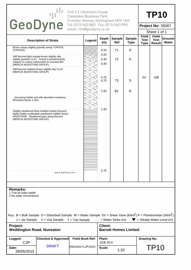
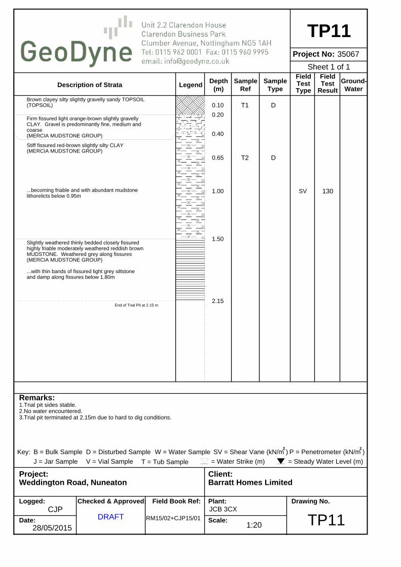
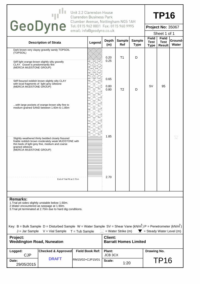
The locations of the exploratory holes are presented in the attached Drawing (Figure No. 35067/Draft) along with draft exploratory hole logs. GROUND CONDITIONS The ground conditions encountered across the site may be summarised as follows: Made Ground Localised Made Ground was encountered at the location of the two potential ponds (TP9 and TP19), and at the location of the old burnt down farm structure in the centre of the site (TP18). Made Ground materials typically comprised loose sandy ash and slag with brick, metal, glass, pipe and ceramic underlain by loose organic clayey sand (possible buried topsoil) beneath the old farm structure extending to a depth of 0.65m begl. The potential old ponds were underlain by loose brown and orange brown clayey gravelly sand with inclusions of brick and concrete, becoming sandy clay with depth and with a basal layer of potential buried topsoil extending to depths ranging between 1.20m to 1.55m begl. Topsoil Across the remainder of the site, the surface materials typically comprised brown clayey gravelly Sand, locally sandy Clay (Topsoil) which extended to depths ranging between 0.15m to 0.30m begl. Whilst this material was recorded as undisturbed Natural Strata, it is likely to contain localised small man-made inclusions.

3 Geotechnical & Environmental Consultants
Natural Strata Beneath the Topsoil and Made Ground, Natural Strata was encountered tentatively assigned as the Mercia Mudstone Group (with localised organic Clay beneath the potential pond anomalies). Within TP9 the Made Ground was underlain by soft grey slightly silty Clay that extended to a depth of 2.20m begl. Beneath the majority of the site the Topsoil was underlain by a layer of stiff fissured silty slightly gravelly Clay (gravel comprising medium to coarse grained subrounded to rounded flint) that may represent naturally re-worked Mercia Mudstone, extending to depths ranging between 0.40m and 0.80m begl. The potentially re-worked Clay was underlain by stiff fissured reddish brown locally with light grey slightly silty Clay extending to depths ranging between 1.30m and >3.00m begl. This layer was locally soft or firm in TP9 and TP19 beneath the potential former ponds to depths of between 1.70m to 2.20m begl (locally not penetrated). The stiff clay locally became highly friable clay with fine to coarse fragments of extremely weak Mudstone in a sandy/clayey matrix. Where penetrated, the stiff clay was underlain by slightly weathered weak thinly bedded closely fissured friable reddish brown Mudstone which was proven to a maximum depth of 3.00m begl but not fully penetrated. Locally, the Mudstone was interbedded with thin beds of medium strong light grey Siltstone or fine grained Sandstone. WATER Water was locally encountered at a depth of 0.85m begl (TP9 and TP19) during advancement through the old infilled ponds. The majority of excavations remained broadly dry during the short time they were open. Locally, dampness was noted along fissures within the fractured Mudstone with slow water seepages being revealed at depths ranging between 1.90m and 2.40m begl within trial pits. Significant dewatering of shallow excavations is considered unlikely to be necessary based on the site observations undertaken to date. Deeper excavations may require water management controls. EXCAVATION STABILITY The sidewalls of the excavations generally remained stable during advancement in Natural Strata, locally with sidewall collapse occurring within Made Ground materials. Therefore, shallow excavations may require sidewall support for health and safety reasons. In addition, deep excavations will require sidewall support for construction purposes i.e. sheet piles or trench boxes. FOUNDATION DESIGN Traditional strip or trench fill foundations may be appropriate for the site placed within the upper layers of the stiff Clay. We consider at this stage the near surface deposits may be suitable to support an allowable ground bearing pressure in the region of 150kN/m2 at an approximate depth of 0.90m begl (subject to confirmation by testing).

4 Geotechnical & Environmental Consultants
Upon site clearance of surface materials or completion of re-grading works to adjust site levels, foundations should be advanced to a minimum depth of between 0.75m to 1.00m below reduced site levels within the Natural Strata (subject to the results of laboratory testing). Furthermore, foundations may require local deepening as necessary, to be in accordance with NHBC Standards Chapter 4.2 ‘Building Near Trees’ where cohesive soils are encountered at founding depth (subject to the findings of geotechnical soil testing). Where Made Ground, soft ground, buried organic soils (TP9, TP18 and TP19), soft spots or former foundations are encountered at founding depth, foundations will require further deepening to encounter the underlying undisturbed suitably competent Natural Strata. FLOOR SLAB DESIGN AND GAS PROTECTION MEASURES Based on the findings of our investigations, initial designs may be progressed based on the following comments: Made Ground was found to be largely absent but locally present in excess of 0.60m thickness. Furthermore, the site may be subject to re-grading works to establish required working levels. Therefore, where there is less than 600mm of geotechnically competent Made Ground beneath a floor slab (or where Made Ground is absent or removed) ground floor slabs may be designed as non-suspended i.e. ground bearing. Alternatively, where Made Ground exceeds 600mm and depending upon the results of the ground gas monitoring programme, the proposed structures at the site may be designed with suspended ground floor slabs i.e. beam and block. The ground gas monitoring programme is ongoing and will inform any ground gas protection requirements for the site which will be confirmed in our final report. BUILDING NEAR TREES Deepening for trees due to volume change potential may be locally required in accordance with NHBC guidance, subject to confirmation by geotechnical classification testing. SURFACE WATER DRAINAGE The presence of mainly visually cohesive strata at the site would indicate that soakaways are unlikely to be suitable at the site for the disposal of surface water. Initial in-situ soakaway testing did not reveal favourable soakaway conditions, with the water levels remaining steady throughout the duration of the tests. Therefore, we would recommend alternative methods of surface water disposal are investigated. RADON The Landmark Envirocheck report indicates that radon protection measures are not required at the site. COAL MINING The site is not in an area requiring the commission of a Coal Authority mining report. Therefore, no coal mining investigations or mitigation measures are required at the site. ROAD CONSTRUCTION CBR values for the Made Ground materials at the site are likely to be less than 2%. Laboratory remoulded CBR tests have been scheduled on three selected samples from near surface Natural Strata obtained from the site and will be reported in our final report.

5 Geotechnical & Environmental Consultants
CONTAMINATION ASSESSMENT Representative soil samples are being scheduled for a suite of chemical testing deemed suitable to provide an initial assessment of the soils at the site. We would comment that no visual or olfactory evidence of gross hydrocarbon contamination was encountered during our works, although the Made Ground materials locally contain elevated concentrations of metals and PAH. Our walkover revealed potential hydrocarbon impaction beneath the AST at the northeastern extent of the site. No access was possible during our site works, however, we will obtain shallow samples by hand excavation/augering to assess the level of any hydrocarbon impaction on the Natural Strata in the area. Encs: Exploratory Hole Location Plan Draft Logs. Conditions and Limitations

Project No. Drawn CJPClient Checked Draft Project Date Drawn Approved Draft
ScaleRevision
Figure No. 35067/Draft
Base plan derived and edited from Client supplied Topographical Drawing
35067 Title Approximate Exploratory Hole Location PlanBarratt HomesWeddington Road, Nuneaton 08/06/2015
NTS
KEY
Approximate Trial Pit Location
TP9
TP8
TP7
TP5
TP4
TP3
TP1
TP10
Approximate Site Boundary
TP6
TP2
Electrified Fence-No Access
TP13
TP12
TP11
TP15TP14TP16
TP17
TP20TP19
TP18
TP22
TP21Approximate Window Sample Borehole Location
(G) Combined Ground Gas/Water Monitoring Point
Location of Hand Grab Samples
HA2HA1
WS1 (G)
WS5 (G)
WS4 (G)
WS3 (G)
WS2 (G)

LegendDepth
Project No:
Description of Strata(m)
SampleRef
SampleType
Field
TypeTest
FieldTest
Result
Ground-Water
Remarks:
Project: Client:
Logged:
Date:
Checked & Approved: Field Book Ref: Plant:
Scale:
Drawing No.
Key: B = Bulk Sample D = Disturbed Sample SV = Shear Vane (kN/m ) P = Penetrometer (kN/m )2 2
W = Water Sample
J = Jar Sample V = Vial Sample = Water Strike (m) = Steady Water Level (m)T = Tub Sample
Weddington Road, Nuneaton
1.Trial pit sides stable.2.No water encountered.
28/05/2015
CJPDRAFT RM15/02+CJP15/01
Barratt Homes Limited
JCB 3CX
TP1
TP135067
0.100.15
0.40
0.500.500.60
0.75
1.00
2.30
T1
T2
B1
T3
D
D
B
D
SV 130
Grass over brown sandy slightly gravelly clayeyTOPSOIL(TOPSOIL)
Firm light orange-brown silty slightly sandy CLAY(SUBSOIL)
Stiff fissured orange-brown slightly silty slightlygravelly CLAY. Gravel is predominantly medium tocoarse subrounded to rounded flint(MERCIA MUDSTONE GROUP)
Very stiff reddish brown silty slightly sandy CLAYlocally with laminations of light grey sandysiltstone(MERCIA MUDSTONE GROUP)
...becoming highly friable with abundant fine tomedium angular fragments of very weak mudstone withbands of stiff red-brown silty clay below 1.15m
Slightly weathered closely fissured highly friablevery weak MUDSTONE. Recovered as dense red-brownfine, medium and coarse angular gravel sizedfragemnts of mudstone(MERCIA MUDSTONE GROUP)
End of Trial Pit at 3.00 m
1:20
Sheet 1 of 1

LegendDepth
Project No:
Description of Strata(m)
SampleRef
SampleType
Field
TypeTest
FieldTest
Result
Ground-Water
Remarks:
Project: Client:
Logged:
Date:
Checked & Approved: Field Book Ref: Plant:
Scale:
Drawing No.
Key: B = Bulk Sample D = Disturbed Sample SV = Shear Vane (kN/m ) P = Penetrometer (kN/m )2 2
W = Water Sample
J = Jar Sample V = Vial Sample = Water Strike (m) = Steady Water Level (m)T = Tub Sample
Weddington Road, Nuneaton
1.Trial pit sides stable.2.No water encountered.
28/05/2015
CJPDRAFT RM15/02+CJP15/01
Barratt Homes Limited
JCB 3CX
TP2
TP235067
0.10
0.20
0.40
0.90
1.00
2.10
2.60
2.90
T1
T2
T3
D
D
D
SV 130
Brown silty slightly clayey slightly gravellysandy TOPSOIL(TOPSOIL)
Stiff fissured light orange-brown silty sandygravelly CLAY. Gravel is predominantly medium tocoarse subrounded to rounded flint(MERCIA MUDSTONE GROUP)
...becoming very stiff fissured reddish brown below0.50m
...becoming highly friable and with abundant fineto medium angular very weak mudstone gravel.Locally with bands of stiff red clay below 1.10m
Slightly weathered closely fissured highly friablevery weak MUDSTONE. Recovered as dense red-brownfine, medium and coarse angular gravel sizedfragments of mudstone. Slightly damp alongfissures(MERCIA MUDSTONE GROUP)
Thinly bedded redish brown moderately weak tomoderately strong SILTSTONE(MERCIA MUDSTONE GROUP)
End of Trial Pit at 2.90 m
1:20
Sheet 1 of 1

LegendDepth
Project No:
Description of Strata(m)
SampleRef
SampleType
Field
TypeTest
FieldTest
Result
Ground-Water
Remarks:
Project: Client:
Logged:
Date:
Checked & Approved: Field Book Ref: Plant:
Scale:
Drawing No.
Key: B = Bulk Sample D = Disturbed Sample SV = Shear Vane (kN/m ) P = Penetrometer (kN/m )2 2
W = Water Sample
J = Jar Sample V = Vial Sample = Water Strike (m) = Steady Water Level (m)T = Tub Sample
Weddington Road, Nuneaton
1.Trial pit sides stable.2.No water encountered.
28/05/2015
CJPDRAFT RM15/02+CJP15/01
Barratt Homes Limited
JCB 3CX
TP3
TP335067
0.100.15
0.50
0.60
0.85
1.00
1.45
2.90
T1
T2
T3/B1
D
D
D/B
SV 105
Turf over brown slightly clayey gravelly sandyTOPSOIL(TOPSOIL)
Stiff fissured light orange-brown and grey sandyslightly gravelly CLAY. Gravel is predominantlyfine, medium and coarse(MERCIA MUDSTONE GROUP)...becoming reddish brown with depth
Very stiff fissured reddish brown slightly siltyCLAY(MERCIA MUDSTONE GROUP)
...becoming friable and with abundant fine tomedium mudstone lithorelicts below 1.05m
Slightly weathered closely fissured highly friablevery weak reddish brown MUDSTONE. Recovered asfine, medium and coarse angular gravel sizedfragments of sandy mudstone(MERCIA MUDSTONE GROUP)
End of Trial Pit at 2.90 m
1:20
Sheet 1 of 1

LegendDepth
Project No:
Description of Strata(m)
SampleRef
SampleType
Field
TypeTest
FieldTest
Result
Ground-Water
Remarks:
Project: Client:
Logged:
Date:
Checked & Approved: Field Book Ref: Plant:
Scale:
Drawing No.
Key: B = Bulk Sample D = Disturbed Sample SV = Shear Vane (kN/m ) P = Penetrometer (kN/m )2 2
W = Water Sample
J = Jar Sample V = Vial Sample = Water Strike (m) = Steady Water Level (m)T = Tub Sample
Weddington Road, Nuneaton
1.Trial pit sides stable.2.Water encountered as seepage at 2.05m.
28/05/2015
CJPDRAFT RM15/02+CJP15/01
Barratt Homes Limited
JCB 3CX
TP4
TP435067
0.10
0.30
0.40
0.50-0.75
0.60
0.750.75
1.00
1.30
1.45
1.60
2.15
T1
T2
B1
T3
B2
D
D
B
D
B
SV 125
Turf over brown clayey silty gravelly sandy TOPSOIL(TOPSOIL)
Firm light orange-brown silty sandy slightlygravelly CLAY. Gravel is predominantly medium tocoarse subrounded to rounded flint(MERCIA MUDSTONE GROUP)
Stiff fissured red-brown silty CLAY(MERCIA MUDSTONE GROUP)
Slightly weathered closely fissured highly friablevery weak reddish brown MUDSTONE. Recovered asfine, medium and coarse angular gravel sizedfragments of sandy mudstone(MERCIA MUDSTONE GROUP)
Light grey moderately weathered SILTSTONE(MERCIA MUDSTONE GROUP)
Thinly laminated closely fissured friable red-brownmoderately weak to moderately strong SILTSTONEwith lenses of light grey siltstone(MERCIA MUDSTONE GROUP)
End of Trial Pit at 2.15 m
1:20
Sheet 1 of 1

LegendDepth
Project No:
Description of Strata(m)
SampleRef
SampleType
Field
TypeTest
FieldTest
Result
Ground-Water
Remarks:
Project: Client:
Logged:
Date:
Checked & Approved: Field Book Ref: Plant:
Scale:
Drawing No.
Key: B = Bulk Sample D = Disturbed Sample SV = Shear Vane (kN/m ) P = Penetrometer (kN/m )2 2
W = Water Sample
J = Jar Sample V = Vial Sample = Water Strike (m) = Steady Water Level (m)T = Tub Sample
Weddington Road, Nuneaton
1.Trial pit sides stable.2.No water encountered.
28/05/2015
CJPDRAFT RM15/02+CJP15/01
Barratt Homes Limited
JCB 3CX
TP5
TP535067
0.10
0.20
0.30
0.450.50-0.75
0.80
1.00
1.70
2.50
T1
T2
B1
T3
D
D
B
D
SV 102
Brown slightly clayey silty gravelly sandy TOPSOIL(TOPSOIL)
Stiff fissured light orange-brown slightly sandygravelly CLAY. Gravel is predominantly medium tocoarse subrounded to rounded flint(MERCIA MUDSTONE GROUP)
Stiff fissured red-brown and light grey silty CLAY(MERCIA MUDSTONE GROUP)
...becoming highly friable and with abundant fineto medium mudstone lithrelicts
Slightly weathered closely fissured highly friablevery weak reddish brown MUDSTONE. Recovered asfine, medium and coarse angular gravel sizedfragments of sandy mudstone(MERCIA MUDSTONE GROUP)
...becoming moderately weak and damp along fissuresbelow 2.20m
End of Trial Pit at 2.50 m
1:20
Sheet 1 of 1

LegendDepth
Project No:
Description of Strata(m)
SampleRef
SampleType
Field
TypeTest
FieldTest
Result
Ground-Water
Remarks:
Project: Client:
Logged:
Date:
Checked & Approved: Field Book Ref: Plant:
Scale:
Drawing No.
Key: B = Bulk Sample D = Disturbed Sample SV = Shear Vane (kN/m ) P = Penetrometer (kN/m )2 2
W = Water Sample
J = Jar Sample V = Vial Sample = Water Strike (m) = Steady Water Level (m)T = Tub Sample
Weddington Road, Nuneaton
1.Trial pit sides stable.2.No water encountered.
28/05/2015
CJPDRAFT RM15/02+CJP15/01
Barratt Homes Limited
JCB 3CX
TP6
TP635067
0.10
0.20
0.40
0.60
0.700.75
2.25
T1
T2
T3
D
D
DSV 130
Brown slightly clayey silty gravelly sandy TOPSOIL(TOPSOIL)
Stiff fissured light orange-brown silty slightlysandy slightly gravelly CLAY. Gravel ispredominantly medium to coarse subrounded torounded flint(MERCIA MUDSTONE GROUP)
Stiff fissured reddish brown silty CLAY(MERCIA MUDSTONE GROUP)
...becoming highly friable and with abundantmudstone lithorelicts, locally with layers of stiffclay below 1.00m
Slightly weathered closely fissured highly friablereddish brown very weak MUDSTONE. Recovered asfine, medium and coarse angular gravel sizedfragments of mudstone(MERCIA MUDSTONE GROUP)
End of Trial Pit at 3.00 m
1:20
Sheet 1 of 1

LegendDepth
Project No:
Description of Strata(m)
SampleRef
SampleType
Field
TypeTest
FieldTest
Result
Ground-Water
Remarks:
Project: Client:
Logged:
Date:
Checked & Approved: Field Book Ref: Plant:
Scale:
Drawing No.
Key: B = Bulk Sample D = Disturbed Sample SV = Shear Vane (kN/m ) P = Penetrometer (kN/m )2 2
W = Water Sample
J = Jar Sample V = Vial Sample = Water Strike (m) = Steady Water Level (m)T = Tub Sample
Weddington Road, Nuneaton
1.Trial pit sides stable.2.No water encountered.
28/05/2015
CJPDRAFT RM15/02+CJP15/01
Barratt Homes Limited
JCB 3CX
TP7
TP735067
0.10
0.20
0.40
0.55-0.80
0.700.75
2.50
T1
T2
B1
T3
D
D
B
DSV 108
Brown clayey slightly gravelly sandy TOPSOIL(TOPSOIL)
Stiff fissured orange-brown and light grey siltyslightly gravelly CLAY. Gravel is predominantlymedium to coarse subrounded to rounded flint(MERCIA MUDSTONE GROUP)
Stiff fissured reddish brown slightly silty CLAY(MERCIA MUDSTONE GROUP)
...becoming highly friable and with abundant fineto medium mudstone lithorelicts below 1.05m
...locally with thin bands of moderately weakred-brown siltstone below 1.80m
End of Trial Pit at 2.50 m
1:20
Sheet 1 of 1

LegendDepth
Project No:
Description of Strata(m)
SampleRef
SampleType
Field
TypeTest
FieldTest
Result
Ground-Water
Remarks:
Project: Client:
Logged:
Date:
Checked & Approved: Field Book Ref: Plant:
Scale:
Drawing No.
Key: B = Bulk Sample D = Disturbed Sample SV = Shear Vane (kN/m ) P = Penetrometer (kN/m )2 2
W = Water Sample
J = Jar Sample V = Vial Sample = Water Strike (m) = Steady Water Level (m)T = Tub Sample
Weddington Road, Nuneaton
1.Trial pit sides stable.2.No water encountered.
28/05/2015
CJPDRAFT RM15/02+CJP15/01
Barratt Homes Limited
JCB 3CX
TP8
TP835067
0.100.15
0.450.50
0.750.75
1.80
T1
T2
B1
D
D
BSV 105
Brown clayey silty slightly gravelly sandy TOPSOIL(TOPSOIL)
Stiff fissured light orange-brown slightly siltyslightly gravelly CLAY. Gravel is predominantlymedium to coarse subrounded to rounded flint(MERCIA MUDSTONE GROUP)
Stiff fissured reddish brown slightly silty CLAY(MERCIA MUDSTONE GROUP)
...becoming highly friable and with abundant fineto medium mudstone lithorelicts
Slightly weathered thinly bedded closely fissuredred-brown moderately weathered MUDSTONE. Recoveredas fine, medium and coarse angular gravel sizedfragments of mudstone(MERCIA MUDSTONE GROUP)
End of Trial Pit at 3.00 m
1:20
Sheet 1 of 1

LegendDepth
Project No:
Description of Strata(m)
SampleRef
SampleType
Field
TypeTest
FieldTest
Result
Ground-Water
Remarks:
Project: Client:
Logged:
Date:
Checked & Approved: Field Book Ref: Plant:
Scale:
Drawing No.
Key: B = Bulk Sample D = Disturbed Sample SV = Shear Vane (kN/m ) P = Penetrometer (kN/m )2 2
W = Water Sample
J = Jar Sample V = Vial Sample = Water Strike (m) = Steady Water Level (m)T = Tub Sample
Weddington Road, Nuneaton
1.Trial pit sides stable.2.Water encountered at 0.85m.3.Trial pit excavated in location of historical pond.
28/05/2015
CJPDRAFT RM15/02+CJP15/01
Barratt Homes Limited
JCB 3CX
TP9
TP935067
0.200.25
1.10
1.201.251.301.40
2.00
2.20
2.30
2.50
T1
T2
D
DSV
SV
SV
15
20
15
Brown clayey sandy topsoil(MADE GROUND)
Loose brown and orange-brown very clayey gravellysand. Gravel is predominantly flint with a littlesandstone and with large cobble sized fragments ofmacadam and locally with bricks(MADE GROUND)
...becoming very soft sandy wet clay below 0.85m
Layer of soft dark brown organic clay with abundantbrown fibrous peaty inclusions(MADE GROUND)
Soft grey slightly silty CLAY(MERCIA MUDSTONE GROUP)
...becoming brown below 2.00m
Soft reddish brown silty CLAY with abundantsiltstone and mudstone fragments(MERCIA MUDSTONE GROUP)
Slightly weathered thinly bedded closely fissuredred-brown moderately weathered MUDSTONE. Recoveredas fine, medium and coarse angular gravel sizedfragments of mudstone(MERCIA MUDSTONE GROUP)
End of Trial Pit at 2.50 m
1:20
Sheet 1 of 1
LegendDepth
Project No:
Description of Strata(m)
SampleRef
SampleType
Field
TypeTest
FieldTest
Result
Ground-Water
Remarks:
Project: Client:
Logged:
Date:
Checked & Approved: Field Book Ref: Plant:
Scale:
Drawing No.
Key: B = Bulk Sample D = Disturbed Sample SV = Shear Vane (kN/m ) P = Penetrometer (kN/m )2 2
W = Water Sample
J = Jar Sample V = Vial Sample = Water Strike (m) = Steady Water Level (m)T = Tub Sample
Weddington Road, Nuneaton
1.Trial pit sides stable.2.No water encountered.
28/05/2015
CJPDRAFT RM15/02+CJP15/01
Barratt Homes Limited
JCB 3CX
TP10
TP1035067
0.10
0.20
0.30
0.40
0.700.75
1.00
1.40
2.75
T1
T2
T3
B1
D
D
D
B
SV 108
Brown clayey slightly gravelly sandy TOPSOIL(TOPSOIL)
Stiff fissured light orange-brown slightly siltyslightly gravelly CLAY. Gravel is predominantlymedium to coarse subrounded to rounded flint(MERCIA MUDSTONE GROUP)
Stiff fissured reddish brown slightly silty CLAY(MERCIA MUDSTONE GROUP)
...becoming friable and with abundant mudstonelithorelicts below 1.10m
Slightly weathered thinly bedded closely fissuredhighly friable moderately weathered reddish brownMUDSTONE. Weathered grey along fissures(MERCIA MUDSTONE GROUP)
End of Trial Pit at 2.75 m
1:20
Sheet 1 of 1
LegendDepth
Project No:
Description of Strata(m)
SampleRef
SampleType
Field
TypeTest
FieldTest
Result
Ground-Water
Remarks:
Project: Client:
Logged:
Date:
Checked & Approved: Field Book Ref: Plant:
Scale:
Drawing No.
Key: B = Bulk Sample D = Disturbed Sample SV = Shear Vane (kN/m ) P = Penetrometer (kN/m )2 2
W = Water Sample
J = Jar Sample V = Vial Sample = Water Strike (m) = Steady Water Level (m)T = Tub Sample
Weddington Road, Nuneaton
1.Trial pit sides stable.2.No water encountered.3.Trial pit terminated at 2.15m due to hard to dig conditions.
28/05/2015
CJPDRAFT RM15/02+CJP15/01
Barratt Homes Limited
JCB 3CX
TP11
TP1135067
0.10
0.20
0.40
0.65
1.00
1.50
2.15
T1
T2
D
D
SV 130
Brown clayey silty slightly gravelly sandy TOPSOIL(TOPSOIL)
Firm fissured light orange-brown slightly gravellyCLAY. Gravel is predominantly fine, medium andcoarse(MERCIA MUDSTONE GROUP)
Stiff fissured red-brown slightly silty CLAY(MERCIA MUDSTONE GROUP)
...becoming friable and with abundant mudstonelithorelicts below 0.95m
Slightly weathered thinly bedded closely fissuredhighly friable moderately weathered reddish brownMUDSTONE. Weathered grey along fissures(MERCIA MUDSTONE GROUP)
...with thin bands of fissured light grey siltstoneand damp along fissures below 1.80m
End of Trial Pit at 2.15 m
1:20
Sheet 1 of 1

LegendDepth
Project No:
Description of Strata(m)
SampleRef
SampleType
Field
TypeTest
FieldTest
Result
Ground-Water
Remarks:
Project: Client:
Logged:
Date:
Checked & Approved: Field Book Ref: Plant:
Scale:
Drawing No.
Key: B = Bulk Sample D = Disturbed Sample SV = Shear Vane (kN/m ) P = Penetrometer (kN/m )2 2
W = Water Sample
J = Jar Sample V = Vial Sample = Water Strike (m) = Steady Water Level (m)T = Tub Sample
Weddington Road, Nuneaton
1.Trial pit sides stable.2.No water encountered.
28/05/2015
CJPDRAFT RM15/02+CJP15/01
Barratt Homes Limited
JCB 3CX
TP12
TP1235067
0.10
0.25
0.40
0.60
0.700.75
1.25
1.45
2.85
T1
T2
B1
D
D
BSV 90
Brown clayey gravelly sandy TOPSOIL(TOPSOIL)
Stiff fissured light orange-brown silty gravellyCLAY. Gravel is predominantly fine, medium andcoarse(MERCIA MUDSTONE GROUP)
Stiff fissured red-brown slightly silty CLAY(MERCIA MUDSTONE GROUP)
...becoming friable and with mudstone lithorelictsbelow 0.80m...with a thin layer of light grey sandy siltstonebelow 0.85m
Firm thinly bedded light grey moderately weatheredslightly silty gravelly SANDSTONE(MERCIA MUDSTONE GROUP)
Firm closely fissured highly friable moderatelyweathered red-brown MUDSTONE. Recovered as fine,medium and coarse angular gravel of mudstone(MERCIA MUDSTONE GROUP)
End of Trial Pit at 2.85 m
1:20
Sheet 1 of 1

LegendDepth
Project No:
Description of Strata(m)
SampleRef
SampleType
Field
TypeTest
FieldTest
Result
Ground-Water
Remarks:
Project: Client:
Logged:
Date:
Checked & Approved: Field Book Ref: Plant:
Scale:
Drawing No.
Key: B = Bulk Sample D = Disturbed Sample SV = Shear Vane (kN/m ) P = Penetrometer (kN/m )2 2
W = Water Sample
J = Jar Sample V = Vial Sample = Water Strike (m) = Steady Water Level (m)T = Tub Sample
Weddington Road, Nuneaton
1.Trial pit sides stable.2.No water encountered.
28/05/2015
CJPDRAFT RM15/02+CJP15/01
Barratt Homes Limited
JCB 3CX
TP13
TP1335067
0.200.25
0.35-0.60
0.450.50
0.70
2.45
T1
B1
T2
D
B
D
SV 102
Brown clayey gravelly sandy TOPSOIL(TOPSOIL)
Stiff light orange-brown silty slightly gravellyCLAY(MERCIA MUDSTONE GROUP)
Stiff fissured reddish brown slightly silty CLAY(MERCIA MUDSTONE GROUP)
...becoming highly friable with abundant mudstonelithorelicts. Recovered as medium dense fine tomedium angular gravel of sandy mudstone gravelbelow 0.75m
Slightly weak thinly bedded closely fissuredfriable reddish brown moderately weathered MUDSTONE(MERCIA MUDSTONE GROUP)
End of Trial Pit at 3.00 m
1:20
Sheet 1 of 1

LegendDepth
Project No:
Description of Strata(m)
SampleRef
SampleType
Field
TypeTest
FieldTest
Result
Ground-Water
Remarks:
Project: Client:
Logged:
Date:
Checked & Approved: Field Book Ref: Plant:
Scale:
Drawing No.
Key: B = Bulk Sample D = Disturbed Sample SV = Shear Vane (kN/m ) P = Penetrometer (kN/m )2 2
W = Water Sample
J = Jar Sample V = Vial Sample = Water Strike (m) = Steady Water Level (m)T = Tub Sample
Weddington Road, Nuneaton
1.Trial pit sides stable.2.No water encountered.
28/05/2015
CJPDRAFT RM15/02+CJP15/01
Barratt Homes Limited
JCB 3CX
TP14
TP1435067
0.10
0.20
0.30
0.40
0.60
0.75
0.90
2.50
T1
T2
B1
T3
D
D
B
D
SV 130
Brown slightly clayey gravelly sandy TOPSOIL(TOPSOIL)
Loose light orange-brown clayey gravelly SAND.Gravel is predominantly flint(MERCIA MUDSTONE GROUP)
Stiff fissured reddish brown slightly silty CLAY(MERCIA MUDSTONE GROUP)
...becoming highly friable and with abundantmudstone lithorelicts and with bands of stiffred-brown clay below 0.85m
...with local lenses of light orange-brown slightlysilty fine to medium grained sand below 1.45m
...with thin lenses of very weak siltstone below2.30m
End of Trial Pit at 2.50 m
1:20
Sheet 1 of 1

LegendDepth
Project No:
Description of Strata(m)
SampleRef
SampleType
Field
TypeTest
FieldTest
Result
Ground-Water
Remarks:
Project: Client:
Logged:
Date:
Checked & Approved: Field Book Ref: Plant:
Scale:
Drawing No.
Key: B = Bulk Sample D = Disturbed Sample SV = Shear Vane (kN/m ) P = Penetrometer (kN/m )2 2
W = Water Sample
J = Jar Sample V = Vial Sample = Water Strike (m) = Steady Water Level (m)T = Tub Sample
Weddington Road, Nuneaton
1.Trial pit sides stable.2.Water encountered as seepage at 2.35m.3.Trial pit terminated at 2.95m due to hard dig conditions.
29/05/2015
CJPDRAFT RM15/02+CJP15/01
Barratt Homes Limited
JCB 3CX
TP15
TP1535067
0.10
0.25
0.50
0.60
0.750.80
2.30
2.95
T1
T2
B1
D
D
BSV 102
Brown clayey slightyly gravelly sandy TOPSOIL(TOPSOIL)
Stiff fissured light orange-brown slightly sandygravelly CLAY. Gravel is predominantly flint(MERCIA MUDSTONE GROUP)
Stiff fissured red-brown with light grey slightlysilty CLAY(MERCIA MUDSTONE GROUP)
...becoming locally friable and with abundantmudstone lithorelicts below 1.20m
...large pocket/lenses of red-brown silty fine tomedium grained sand and sandy clay below 1.70m
Slightly weathered thinly bedded closely fissuredfriable reddish brown moderately weak MUDSTONE(MERCIA MUDSTONE GROUP)
End of Trial Pit at 2.95 m
1:20
Sheet 1 of 1
LegendDepth
Project No:
Description of Strata(m)
SampleRef
SampleType
Field
TypeTest
FieldTest
Result
Ground-Water
Remarks:
Project: Client:
Logged:
Date:
Checked & Approved: Field Book Ref: Plant:
Scale:
Drawing No.
Key: B = Bulk Sample D = Disturbed Sample SV = Shear Vane (kN/m ) P = Penetrometer (kN/m )2 2
W = Water Sample
J = Jar Sample V = Vial Sample = Water Strike (m) = Steady Water Level (m)T = Tub Sample
Weddington Road, Nuneaton
1.Trial pit sides slightly unstable below 1.60m.2.Water encountered as seepage at 1.90m.3.Trial pit terminated at 2.70m due to hard dig conditions.
29/05/2015
CJPDRAFT RM15/02+CJP15/01
Barratt Homes Limited
JCB 3CX
TP16
TP1635067
0.200.25
0.65
0.800.80
1.85
2.70
T1
T2
D
DSV 95
Dark brown very clayey gravelly sandy TOPSOIL(TOPSOIL)
Stiff light orange-brown slightly silty gravellyCLAY. Gravel is predominantly flint(MERCIA MUDSTONE GROUP)
Stiff fissured reddish brown slightly silty CLAYwith local fragments of light grey siltstone(MERCIA MUDSTONE GROUP)
...with large pockets of orange-brown silty fine tomedium grained SAND between 1.60m to 1.85m
Slightly weathered thinly bedded closely fissuredfriable reddish brown moderately weak MUDSTONE withthin beds of light grey fine, medium and coarsegrained siltstone(MERCIA MUDSTONE GROUP)
End of Trial Pit at 2.70 m
1:20
Sheet 1 of 1

LegendDepth
Project No:
Description of Strata(m)
SampleRef
SampleType
Field
TypeTest
FieldTest
Result
Ground-Water
Remarks:
Project: Client:
Logged:
Date:
Checked & Approved: Field Book Ref: Plant:
Scale:
Drawing No.
Key: B = Bulk Sample D = Disturbed Sample SV = Shear Vane (kN/m ) P = Penetrometer (kN/m )2 2
W = Water Sample
J = Jar Sample V = Vial Sample = Water Strike (m) = Steady Water Level (m)T = Tub Sample
Weddington Road, Nuneaton
1.Trial pit sides stable.2.Water encountered as seepage at 2.35m.3.Trial pit terminated at 2.60m due to hard dig conditions.
29/05/2015
CJPDRAFT RM15/02+CJP15/01
Barratt Homes Limited
JCB 3CX
TP17
TP1735067
0.15
0.25
0.50
0.60
0.800.80
2.30
2.60
T1
T2
B1
D
D
BSV 100
Brown clayey gravelly sandy TOPSOIL(TOPSOIL)
Stiff fissured light orange-brown locally lightgrey silty very sandy slightly gravelly CLAY.Gravel is predominantly fine,medium and coarse(MERCIA MUDSTONE GROUP)
Stiff fissured reddish brown slightly silty CLAY(MERCIA MUDSTONE GROUP)
...becoming friable and with mudstone lithorelictsbelow 1.10m
Slightly weathered thinly bedded closely fissuredfriable reddish brown moderately weak MUDSTONE(MERCIA MUDSTONE GROUP)
End of Trial Pit at 2.60 m
1:20
Sheet 1 of 1

LegendDepth
Project No:
Description of Strata(m)
SampleRef
SampleType
Field
TypeTest
FieldTest
Result
Ground-Water
Remarks:
Project: Client:
Logged:
Date:
Checked & Approved: Field Book Ref: Plant:
Scale:
Drawing No.
Key: B = Bulk Sample D = Disturbed Sample SV = Shear Vane (kN/m ) P = Penetrometer (kN/m )2 2
W = Water Sample
J = Jar Sample V = Vial Sample = Water Strike (m) = Steady Water Level (m)T = Tub Sample
Weddington Road, Nuneaton
1.Trial pit sides stable.2.No water encountered.3.Trial pit terminated at 2.80m due to hard dig conditions.4.Trial pit excavated through spoil/disturbed ground in location of former barn.
29/05/2015
CJPDRAFT RM15/02+CJP15/01
Barratt Homes Limited
JCB 3CX
TP18
TP1835067
0.30
0.40
0.65
0.750.80
1.00
2.70
2.80
T1
T2
D
D
SV 92
Loose grey sandy ash and slag with fragments ofbrick, metal, glass, concrete, pipe and ceramic(MADE GROUND)
Loose brown organic clayey sand with rare fragmentsof concrete(MADE GROUND - POSSIBLE BURIED TOPSOIL)
Stiff orange-brown slightly silty gravelly CLAY(MERCIA MUDSTONE GROUP)
Stiff fissured red-brown slightly silty CLAY(MERCIA MUDSTONE GROUP)
...with mudstone lithorelicts below 1.55m
Slightly weathered thinly bedded closely fissuredfriable reddish brown moderately weak MUDSTONE.Locally light grey with sandstone bands
Continued on next sheet
1:20
Sheet 1 of 1

LegendDepth
Project No:
Description of Strata(m)
SampleRef
SampleType
Field
TypeTest
FieldTest
Result
Ground-Water
Remarks:
Project: Client:
Logged:
Date:
Checked & Approved: Field Book Ref: Plant:
Scale:
Drawing No.
Key: B = Bulk Sample D = Disturbed Sample SV = Shear Vane (kN/m ) P = Penetrometer (kN/m )2 2
W = Water Sample
J = Jar Sample V = Vial Sample = Water Strike (m) = Steady Water Level (m)T = Tub Sample
Weddington Road, Nuneaton
1.Trial pit sides stable.2.No water encountered.3.Trial pit terminated at 2.80m due to hard dig conditions.4.Trial pit excavated through spoil/disturbed ground in location of former barn.
29/05/2015
CJPDRAFT RM15/02+CJP15/01
Barratt Homes Limited
JCB 3CX
TP18
TP1835067
(MERCIA MUDSTONE GROUP)
End of Trial Pit at 2.80 m
1:20
Sheet 1+ of 1

LegendDepth
Project No:
Description of Strata(m)
SampleRef
SampleType
Field
TypeTest
FieldTest
Result
Ground-Water
Remarks:
Project: Client:
Logged:
Date:
Checked & Approved: Field Book Ref: Plant:
Scale:
Drawing No.
Key: B = Bulk Sample D = Disturbed Sample SV = Shear Vane (kN/m ) P = Penetrometer (kN/m )2 2
W = Water Sample
J = Jar Sample V = Vial Sample = Water Strike (m) = Steady Water Level (m)T = Tub Sample
Weddington Road, Nuneaton
1.Trial pit sides unstable within Made Ground.2.Water encountered as seepage at 0.85m.3.Trial pit excavated in location of historical pond.
29/05/2015
CJPDRAFT RM15/02+CJP15/01
Barratt Homes Limited
JCB 3CX
TP19
TP1935067
0.30
0.75
1.00
1.30
1.55
1.701.75
2.80
T1
T2
T3
D
D
D
SV 15
Loose light brown slightly clayey silty slightlygravelly sand. Gravel is predominantly fine tomedium flint, rare concrete, brick and timber(MADE GROUND)
...becoming very soft and very sandy clay below0.65m
Black sandy clay with abundant root fragments anddecomposed grass (possible buried topsoil)(MADE GROUND)
Firm reddish brown slightly silty CLAY withinclusions of mudstone(MERCIA MUDSTONE GROUP)
Slightly weathered thinly bedded closely fissuredfriable reddish brown and light grey moderatelyweak MUDSTONE(MERCIA MUDSTONE GROUP)
End of Trial Pit at 2.80 m
1:20
Sheet 1 of 1
LegendDepth
Project No:
Description of Strata(m)
SampleRef
SampleType
Field
TypeTest
FieldTest
Result
Ground-Water
Remarks:
Project: Client:
Logged:
Date:
Checked & Approved: Field Book Ref: Plant:
Scale:
Drawing No.
Key: B = Bulk Sample D = Disturbed Sample SV = Shear Vane (kN/m ) P = Penetrometer (kN/m )2 2
W = Water Sample
J = Jar Sample V = Vial Sample = Water Strike (m) = Steady Water Level (m)T = Tub Sample
Weddington Road, Nuneaton
1.Trial pit sides stable.2.No water encountered.
29/05/2015
CJPDRAFT RM15/02+CJP15/01
Barratt Homes Limited
JCB 3CX
TP20
TP2035067
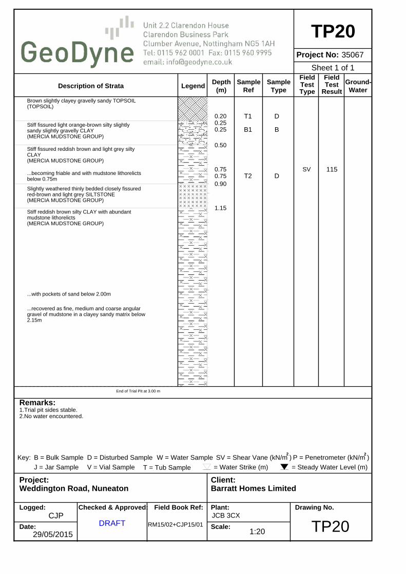
0.200.250.25
0.50
0.750.750.90
1.15
T1
B1
T2
D
B
DSV 115
Brown slightly clayey gravelly sandy TOPSOIL(TOPSOIL)
Stiff fissured light orange-brown silty slightlysandy slightly gravelly CLAY(MERCIA MUDSTONE GROUP)
Stiff fissured reddish brown and light grey siltyCLAY(MERCIA MUDSTONE GROUP)
...becoming friable and with mudstone lithorelictsbelow 0.75m
Slightly weathered thinly bedded closely fissuredred-brown and light grey SILTSTONE(MERCIA MUDSTONE GROUP)
Stiff reddish brown silty CLAY with abundantmudstone lithorelicts(MERCIA MUDSTONE GROUP)
...with pockets of sand below 2.00m
...recovered as fine, medium and coarse angulargravel of mudstone in a clayey sandy matrix below2.15m
End of Trial Pit at 3.00 m
1:20
Sheet 1 of 1
LegendDepth
Project No:
Description of Strata(m)
SampleRef
SampleType
Field
TypeTest
FieldTest
Result
Ground-Water
Remarks:
Project: Client:
Logged:
Date:
Checked & Approved: Field Book Ref: Plant:
Scale:
Drawing No.
Key: B = Bulk Sample D = Disturbed Sample SV = Shear Vane (kN/m ) P = Penetrometer (kN/m )2 2
W = Water Sample
J = Jar Sample V = Vial Sample = Water Strike (m) = Steady Water Level (m)T = Tub Sample
Weddington Road, Nuneaton
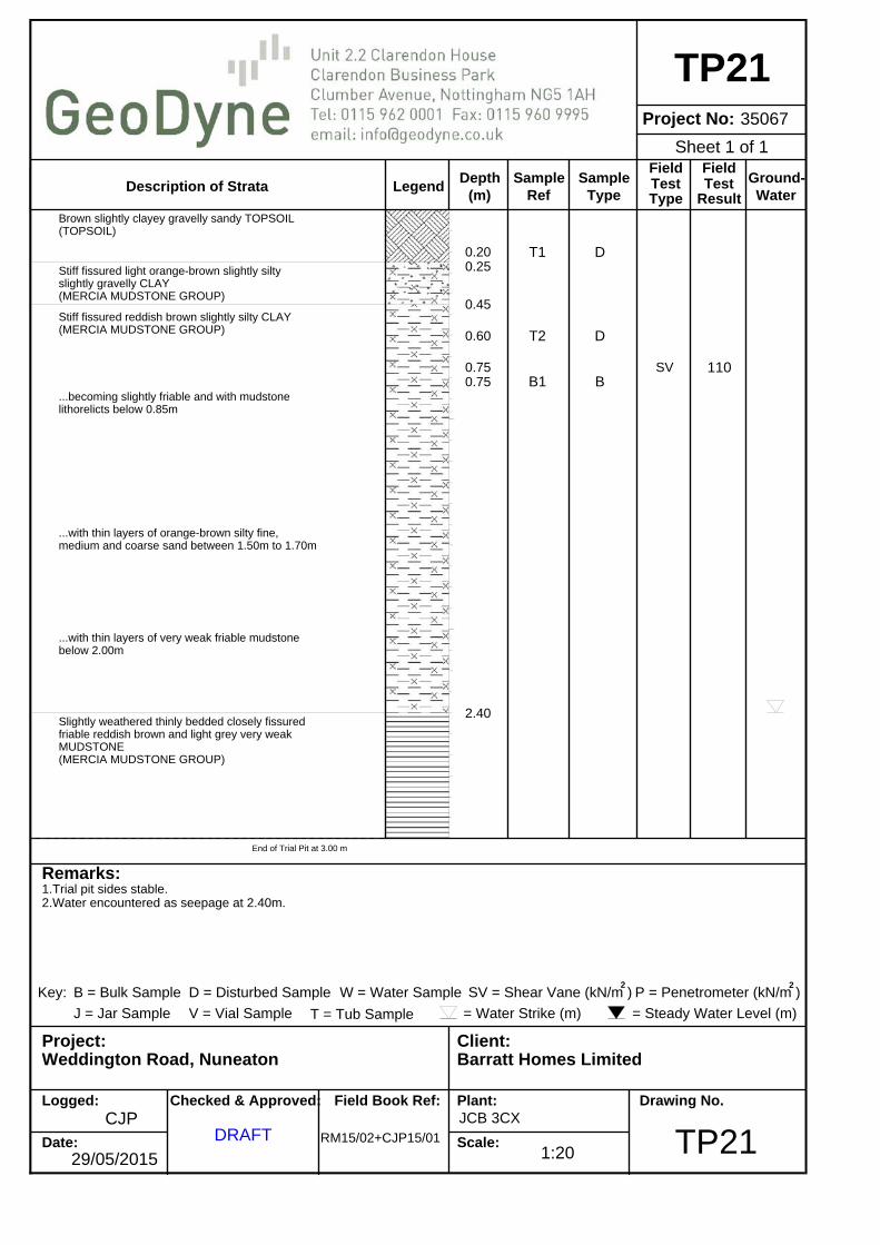
1.Trial pit sides stable.2.Water encountered as seepage at 2.40m.
29/05/2015
CJPDRAFT RM15/02+CJP15/01
Barratt Homes Limited
JCB 3CX
TP21
TP2135067
0.200.25
0.45
0.60
0.750.75
2.40
T1
T2
B1
D
D
BSV 110
Brown slightly clayey gravelly sandy TOPSOIL(TOPSOIL)
Stiff fissured light orange-brown slightly siltyslightly gravelly CLAY(MERCIA MUDSTONE GROUP)
Stiff fissured reddish brown slightly silty CLAY(MERCIA MUDSTONE GROUP)
...becoming slightly friable and with mudstonelithorelicts below 0.85m
...with thin layers of orange-brown silty fine,medium and coarse sand between 1.50m to 1.70m
...with thin layers of very weak friable mudstonebelow 2.00m
Slightly weathered thinly bedded closely fissuredfriable reddish brown and light grey very weakMUDSTONE(MERCIA MUDSTONE GROUP)
End of Trial Pit at 3.00 m
1:20
Sheet 1 of 1
LegendDepth
Project No:
Description of Strata(m)
SampleRef
SampleType
Field
TypeTest
FieldTest
Result
Ground-Water
Remarks:
Project: Client:
Logged:
Date:
Checked & Approved: Field Book Ref: Plant:
Scale:
Drawing No.
Key: B = Bulk Sample D = Disturbed Sample SV = Shear Vane (kN/m ) P = Penetrometer (kN/m )2 2
W = Water Sample
J = Jar Sample V = Vial Sample = Water Strike (m) = Steady Water Level (m)T = Tub Sample
Weddington Road, Nuneaton
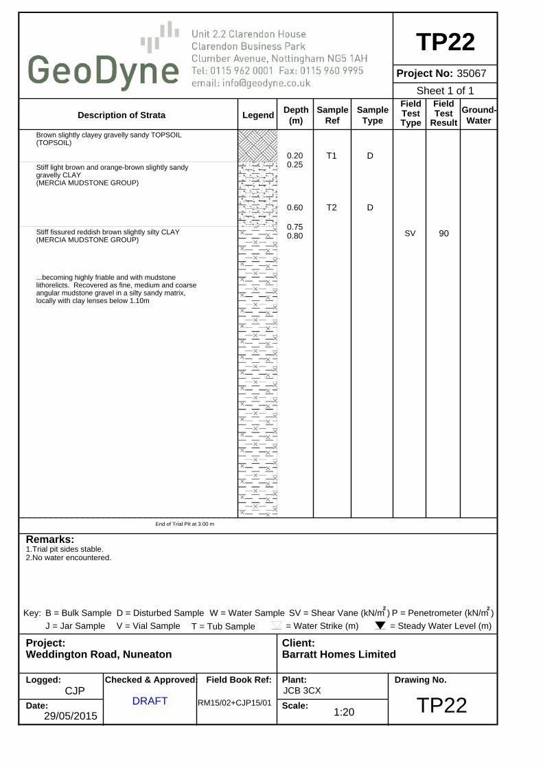
1.Trial pit sides stable.2.No water encountered.
29/05/2015
CJPDRAFT RM15/02+CJP15/01
Barratt Homes Limited
JCB 3CX
TP22
TP2235067
0.200.25
0.60
0.750.80
T1
T2
D
D
SV 90
Brown slightly clayey gravelly sandy TOPSOIL(TOPSOIL)
Stiff light brown and orange-brown slightly sandygravelly CLAY(MERCIA MUDSTONE GROUP)
Stiff fissured reddish brown slightly silty CLAY(MERCIA MUDSTONE GROUP)
...becoming highly friable and with mudstonelithorelicts. Recovered as fine, medium and coarseangular mudstone gravel in a silty sandy matrix,locally with clay lenses below 1.10m
End of Trial Pit at 3.00 m
1:20
Sheet 1 of 1

Depth &LegendDepth (Thickness)
Project No.
Type Sample SPT(m) Ref "N"
Value
Samples and TestsDescription of Strata
(m)Casing
(m)
Ground-water Installation
Remarks:
Project:
Logged:
Date:
Client:
Checked & Approved: Field Book Ref: Plant:
Scale:
Drawing Ref:
Key: D
U
B
JW
=
=
=
==
Disturbed Sample
Undisturbed Sample
Bulk Sample
Jar SampleWater Sample
S
C
=
=
Standard Penetration Test
Standard Penetration Test
=
=Water Strike (m)Steady Water Level (m)
(Split Spoon)
(Cone)
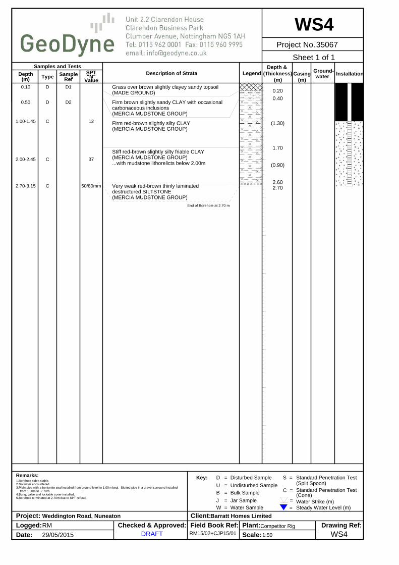
1.Borehole sides stable.2.No water encountered.3.Plain pipe with a bentonite seal installed from ground level to 1.00m begl. Slotted pipe in a gravel surround installed
from 1.00m to 2.70m.4.Bung, valve and lockable cover installed.5.Borehole terminated at 2.70m due to SPT refusal
RM
29/05/2015
Weddington Road, Nuneaton
DRAFT
Barratt Homes Limited
RM15/02+CJP15/01Competitor Rig
WS135067
WS1
0.10
0.60
0.80
1.00-1.45
2.00-2.45
2.70-3.15
D
D
B
C
C
C
D1
D2
B1
17
41
50/230mm
0.20
0.45
(0.95)
1.40
(1.30)
2.70
Grass over brown slightly sandy slightlygravelly clayey topsoil with rare fragments ofbrick and carbonaceous inclusions(MADE GROUND)
Firm brown slightly sandy gravelly CLAY.Gravel is predominantly fine to coarsesubangular to subrounded flint(MERCIA MUDSTONE GROUP)
Stiff red-brown slightly silty CLAY. Gravelis predominantly fine, medium and coarsemudstone(MERCIA MUDSTONE GROUP)
Stiff red-brown friable CLAY with occasionalmudstone lithorelicts(MERCIA MUDSTONE GROUP)
End of Borehole at 2.70 m
1:50
Sheet 1 of 1

Depth &LegendDepth (Thickness)
Project No.
Type Sample SPT(m) Ref "N"
Value
Samples and TestsDescription of Strata
(m)Casing
(m)
Ground-water Installation
Remarks:
Project:
Logged:
Date:
Client:
Checked & Approved: Field Book Ref: Plant:
Scale:
Drawing Ref:
Key: D
U
B
JW
=
=
=
==
Disturbed Sample
Undisturbed Sample
Bulk Sample
Jar SampleWater Sample
S
C
=
=
Standard Penetration Test
Standard Penetration Test
=
=Water Strike (m)Steady Water Level (m)
(Split Spoon)
(Cone)
1.Borehole sides stable.2.No water encountered.3.Plain pipe with a bentonite seal installed from ground level to 1.00m begl. Slotted pipe in a gravel surround installed
from 1.00m to 2.50m.4.Bung, valve and lockable cover installed.5.Borehole terminated at 2.50m due to SPT refusal
RM
29/05/2015
Weddington Road, Nuneaton
DRAFT
Barratt Homes Limited
RM15/02+CJP15/01Competitor Rig
WS235067
WS2
0.15
0.80
1.00-1.45
2.00-2.45
2.50-2.95
D
D
C
C
C
D1
D2
12
31
50/70mm
(0.30)0.30
(0.90)
1.20
(0.70)
1.90
(0.60)
2.50
Grass over brown slightly sandy slightlygravelly clayey topsoil. Gravel ispredominantly fine to coarse subangular flint(MADE GROUND)
Firm red-brown slightly silty CLAY withoccasional fine to medium subangular mudstonegravel(MERCIA MUDSTONE GROUP)
Firm to stiff red-brown with occasionalgrey-brown pockets slightly silty CLAY(MERCIA MUDSTONE GROUP)
Stiff red-brown friable CLAY wirth occasionalmudstone lithorelicts(MERCIA MUDSTONE GROUP)
End of Borehole at 2.50 m
1:50
Sheet 1 of 1

Depth &LegendDepth (Thickness)
Project No.
Type Sample SPT(m) Ref "N"
Value
Samples and TestsDescription of Strata
(m)Casing
(m)
Ground-water Installation
Remarks:
Project:
Logged:
Date:
Client:
Checked & Approved: Field Book Ref: Plant:
Scale:
Drawing Ref:
Key: D
U
B
JW
=
=
=
==
Disturbed Sample
Undisturbed Sample
Bulk Sample
Jar SampleWater Sample
S
C
=
=
Standard Penetration Test
Standard Penetration Test
=
=Water Strike (m)Steady Water Level (m)
(Split Spoon)
(Cone)
1.Borehole sides stable.2.No water encountered.3.Plain pipe with a bentonite seal installed from ground level to 1.00m begl. Slotted pipe in a gravel surround installed
from 1.00m to 1.70m.4.Bung, valve and lockable cover installed.5.Borehole terminated at 1.70m due to SPT refusal
RM
29/05/2015
Weddington Road, Nuneaton
DRAFT
Barratt Homes Limited
RM15/02+CJP15/01Competitor Rig
WS335067
WS3
0.10
0.60
0.80
1.00-1.45
1.50-1.95
D
D
B
C
C
D1
D2
B1
13
50/285mm
(0.30)0.30
(0.30)0.60
(1.10)
1.70
Grass over brown sandy clayey topsoil(MADE GROUND)
Firm brown slightly sandy slightly gravellyCLAY. Gravel is predominantly fine to coarsesubangular to subrounded flint(MERCIA MUDSTONE GROUP)
Firm red-brown slightly silty CLAY withmudstone lithorelicts(MERCIA MUDSTONE GROUP)...becoming stiff below 1.20m
End of Borehole at 1.70 m
1:50
Sheet 1 of 1
Depth &LegendDepth (Thickness)
Project No.
Type Sample SPT(m) Ref "N"
Value
Samples and TestsDescription of Strata
(m)Casing
(m)
Ground-water Installation
Remarks:
Project:
Logged:
Date:
Client:
Checked & Approved: Field Book Ref: Plant:
Scale:
Drawing Ref:
Key: D
U
B
JW
=
=
=
==
Disturbed Sample
Undisturbed Sample
Bulk Sample
Jar SampleWater Sample
S
C
=
=
Standard Penetration Test
Standard Penetration Test
=
=Water Strike (m)Steady Water Level (m)
(Split Spoon)
(Cone)
1.Borehole sides stable.2.No water encountered.3.Plain pipe with a bentonite seal installed from ground level to 1.00m begl. Slotted pipe in a gravel surround installed
from 1.00m to 2.70m.4.Bung, valve and lockable cover installed.5.Borehole terminated at 2.70m due to SPT refusal
RM
29/05/2015
Weddington Road, Nuneaton
DRAFT
Barratt Homes Limited
RM15/02+CJP15/01Competitor Rig
WS435067
WS4
0.10
0.50
1.00-1.45
2.00-2.45
2.70-3.15
D
D
C
C
C
D1
D2
12
37
50/80mm
0.20
0.40
(1.30)
1.70
(0.90)
2.602.70
Grass over brown slightly clayey sandy topsoil(MADE GROUND)
Firm brown slightly sandy CLAY with occasionalcarbonaceous inclusions(MERCIA MUDSTONE GROUP)
Firm red-brown slightly silty CLAY(MERCIA MUDSTONE GROUP)
Stiff red-brown slightly silty friable CLAY(MERCIA MUDSTONE GROUP)...with mudstone lithorelicts below 2.00m
Very weak red-brown thinly laminateddestructured SILTSTONE(MERCIA MUDSTONE GROUP)
End of Borehole at 2.70 m
1:50
Sheet 1 of 1

Depth &LegendDepth (Thickness)
Project No.
Type Sample SPT(m) Ref "N"
Value
Samples and TestsDescription of Strata
(m)Casing
(m)
Ground-water Installation
Remarks:
Project:
Logged:
Date:
Client:
Checked & Approved: Field Book Ref: Plant:
Scale:
Drawing Ref:
Key: D
U
B
JW
=
=
=
==
Disturbed Sample
Undisturbed Sample
Bulk Sample
Jar SampleWater Sample
S
C
=
=
Standard Penetration Test
Standard Penetration Test
=
=Water Strike (m)Steady Water Level (m)
(Split Spoon)
(Cone)
1.Borehole sides stable.2.No water encountered.3.Plain pipe with a bentonite seal installed from ground level to 1.00m begl. Slotted pipe in a gravel surround installed
from 1.00m to 2.50m.4.Bung, valve and lockable cover installed.5.Borehole terminated at 2.50m due to SPT refusal
RM
29/05/2015
Weddington Road, Nuneaton
DRAFT
Barratt Homes Limited
RM15/02+CJP15/01Competitor Rig
WS535067
WS5
0.10
0.70
0.901.00-1.45
2.00-2.45
2.50-2.95
D
B
DC
C
C
D1
B1
D210
29
50/125mm
(0.30)0.30
(0.30)0.60
(1.40)
2.00(0.30)2.30
2.50
Grass over brown slightly clayey sandy topsoil(MADE GROUND)
Firm light brown slightly sandy slightlygravelly CLAY. Gravel is predominantly fineto coarse subangular to subrounded flint(MERCIA MUDSTONE GROUP)
Firm red-brown slightly silty CLAY withoccasional grey pockets(MERCIA MUDSTONE GROUP)
...with root traces at 1.70m
Stiff red-brown slightly silty friable CLAY(MERCIA MUDSTONE GROUP)
Very weak red-brown thinly laminateddestructured MUDSTONE(MERCIA MUDSTONE GROUP)
End of Borehole at 2.50 m
1:50
Sheet 1 of 1

Conditions & Limitations Phase I Desk Studies 1. Works undertaken to provide the basis of the Phase I Desk Study report comprise a review of information available from a
number of sources/parties (potentially also including the Client) together with a walk over of the site (where applicable and included within the quotation). The opinions given in the Phase I Desk Study are based on the information available from third parties/sources that has been obtained within the available timeframe. GeoDyne Limited assumes all third party information to be true and correct and therefore cannot accept liability for the accuracy of such information supplied.
2. Should additional information become available that may affect the comments and opinions made within the Phase I Desk
Study, GeoDyne Limited reserves the right to review such information and make modifications to comments/opinions as appropriate.
3. It should be borne in mind that a Phase I Desk Study collates available information to generate a conceptual model of the site.
The actual geotechnical and environmental considerations can only be fully quantified by intrusive investigation works to confirm the accuracy of the conceptual site model.
Phase II Intrusive Investigations 1. Our quotation assumes that access to the site will be arranged by others at no cost to ourselves. 2. We have assumed that free access is available throughout to the entire site and that works can be undertaken during a single
mobilisation. Where restricted access is encountered, or where additional unscheduled mobilisations are required, additional costs may be incurred to the client.
3. We have assumed that all available information relating to buried services will be supplied by the Client at no cost to ourselves.
No responsibility will be accepted for damage to underground services that have not been brought to our prior attention by the Client.
4. All excavations/boreholes will be backfilled with compacted arisings upon completion, with any excess arisings left proud of
ground levels. Excess arisings will not be removed from the site unless specifically requested by the Client. Where we are requested to remove excess arisings, all associated costs will be passed to the Client.
5. We will attempt to leave the site in a clean and tidy state, however, it must be understood that some disturbance of the site is
unavoidable during intrusive works. 6. Exploratory holes are positioned approximately on site by GeoDyne Limited. Should the client require precise locations of all
exploratory points, additional fees will be incurred. It must be borne in mind that backfilled trial pits can create ‘soft spots’, therefore, should the Client wish to designate ‘no dig’ zones, for example under the footprint of proposed structures, these must be brought to our attention prior to commencement of works.
7. Groundwater observations relate to conditions encountered at the time of investigation. It must be understood that groundwater
levels may vary as a result of recent climatic conditions or seasonal variation. 8. Trial pits and boreholes examine only a small proportion of the total site area. No liability can be accepted for conditions not
revealed in exploratory holes, particularly between positions. All extrapolations of available data are given in good faith. Payment 1 Payment terms are strictly 28 days from the invoice date. 2 Prior to commencement of works, we require receipt of formal written instruction from the party accepting full financial
responsibility for the work. In the absence of such an instruction, we would expect the instructing Consulting Engineers/Architects to accept full financial responsibility for the works.
3 Receipt of instruction to commence work shall be taken as acceptance and compliance of the foregoing conditions. Liability 1. GeoDyne Limited offer £5,000,000.00 Professional Indemnity Insurance (in aggregate over the year). This shall be the limit of
our liability for works undertaken. No individual liability shall be implied to, or accepted by, any employee for works undertaken for and on the behalf of GeoDyne Limited.