grey mares tail walking trail
DESCRIPTION
Grey Mares Tail Walking TrailTRANSCRIPT
1 2
3
4
5
10
9
7
6
8
11
1
2 8
7
10
93
5
4
11
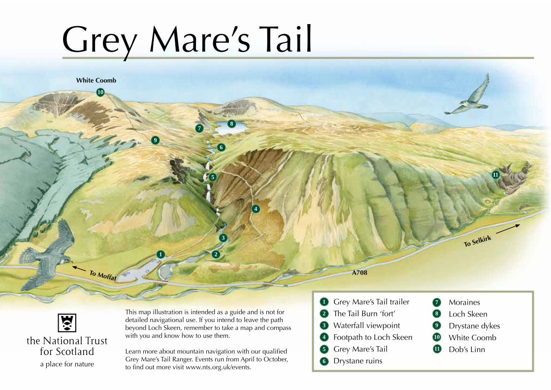
Grey Mare’s Tail trailer
The Tail Burn ‘fort’
Waterfall viewpoint
Footpath to Loch Skeen
Grey Mare’s Tail
Drystane ruins6
Moraines
Loch Skeen
Drystane dykes
White Coomb
Dob’s Linn
Grey Mare’s TailWhite Coomb
To Selkirk
A708To Moffat
This map illustration is intended as a guide and is not for detailed navigational use. If you intend to leave the path beyond Loch Skeen, remember to take a map and compass with you and know how to use them.
Learn more about mountain navigation with our qualified Grey Mare’s Tail Ranger. Events run from April to October, to find out more visit www.nts.org.uk/events.
R C 29/ 10/ 2012
www.nts.org.uk 0844 493 2249 [email protected]
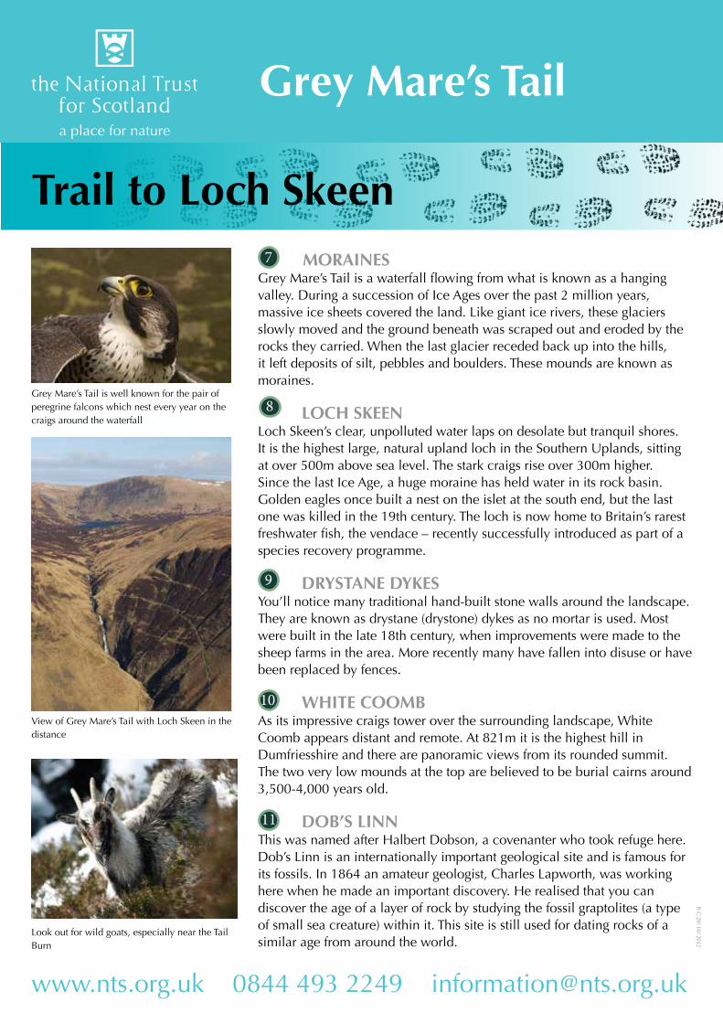
MORAINESGrey Mare’s Tail is a waterfall flowing from what is known as a hanging valley. During a succession of Ice Ages over the past 2 million years, massive ice sheets covered the land. Like giant ice rivers, these glaciers slowly moved and the ground beneath was scraped out and eroded by the rocks they carried. When the last glacier receded back up into the hills, it left deposits of silt, pebbles and boulders. These mounds are known as moraines.
LOCH SKEENLoch Skeen’s clear, unpolluted water laps on desolate but tranquil shores. It is the highest large, natural upland loch in the Southern Uplands, sitting at over 500m above sea level. The stark craigs rise over 300m higher. Since the last Ice Age, a huge moraine has held water in its rock basin. Golden eagles once built a nest on the islet at the south end, but the last one was killed in the 19th century. The loch is now home to Britain’s rarest freshwater fish, the vendace – recently successfully introduced as part of a species recovery programme.
DRYSTANE DYKESYou’ll notice many traditional hand-built stone walls around the landscape. They are known as drystane (drystone) dykes as no mortar is used. Most were built in the late 18th century, when improvements were made to the sheep farms in the area. More recently many have fallen into disuse or have been replaced by fences.
WHITE COOMBAs its impressive craigs tower over the surrounding landscape, White Coomb appears distant and remote. At 821m it is the highest hill in Dumfriesshire and there are panoramic views from its rounded summit. The two very low mounds at the top are believed to be burial cairns around 3,500-4,000 years old.
DOB’S LINNThis was named after Halbert Dobson, a covenanter who took refuge here. Dob’s Linn is an internationally important geological site and is famous for its fossils. In 1864 an amateur geologist, Charles Lapworth, was working here when he made an important discovery. He realised that you can discover the age of a layer of rock by studying the fossil graptolites (a type of small sea creature) within it. This site is still used for dating rocks of a similar age from around the world.
7
9
11
10
8Grey Mare’s Tail is well known for the pair of peregrine falcons which nest every year on the craigs around the waterfall
Look out for wild goats, especially near the Tail Burn
View of Grey Mare’s Tail with Loch Skeen in the distance
Trail to Loch Skeen
Grey Mare’s Tail

R C 29/ 10/ 2012
DescriptionThe steep path is worth the effort as you climb past the spectacular waterfall. Venturing further, the secrets of this hanging valley will gradually unfold, revealing the picturesque Loch Skeen, and striking views from White Coomb.
GradeStrenuous
TerrainThe paths are rough and steep in places and can be dangerous. Please wear footwear with good grip and keep to the paths. The weather can change dramatically, even in summer, and warm, waterproof clothing is essential. The map illustration is not intended for navigational use.
DistanceTo Loch Skene 1.2 miles / 2Km
TimeTo Loch Skene approximately 1 hour
OS MapLandranger Sheet 79
Estate FacilitiesParkingDogs welcome but must be kept under control at all timesInformation at ranger trailer
www.nts.org.uk 0844 493 2249 [email protected] The Trust is supported by
GREY MARE’S TAIL TRAILERIn summer months, you can visit the ranger’s trailer where staff and volunteers will be able to give you any information you require about the site. You can also take a closer look at the peregrine falcon’s nest through our CCTV link.
THE TAIL BURN ‘FORT’The terrace (or terminal moraine) above the car park on the north side of the burn has a prehistoric bank and ditch along its edge, constructed around 2,000 years ago. The long bank has been known as the Giant’s Grave since the early 19th century, but it isn’t a burial mound. The name reflects the fact that archaeologists have various theories as to the use of the site. Was it defensive, or could it have been a place for pagan ceremonies? Look out for wild goats as you follow the Tail Burn up the path.
WATERFALL VIEWPOINTThe safest view of the waterfall is from the drystane enclosure on the right-hand side of the Tail Burn. This resembles the stells or sheepfolds that were once common in the landscape. Above this are the steps that take you on the steep path to Loch Skeen.
FOOTPATH TO LOCH SKEENThe steep path clinging to the right-hand side of the gorge offers excellent views. It takes about an hour to reach Loch Skeen.
GREY MARE’S TAILThe Grey Mare’s Tail is one of the most spectacular landmarks in southern Scotland. The Tail Burn plunges 60m (200ft) into a gorge, forming the fifth highest cascade in Britain. Its name is thought to be descriptive – do you think it looks like a horse’s tail?
DRYSTANE RUINSShepherds once used these buildings as summer shelters. Walter Scott (no relation to the writer) lived by Loch Skeen with his family in the 19th century. One wild stormy night while he was out with his sheep, the roof blew off his house. Mrs Scott tied her son to her back and walked 3 miles through the wind and rain to Polmoodie for shelter.
1
5
4
3
2
6
Trail to Loch Skeen
Grey Mare’s Tail
Grey Mare’s Tail