green infrastructure and housing development · green infrastructure and housing development . 4 ....
TRANSCRIPT
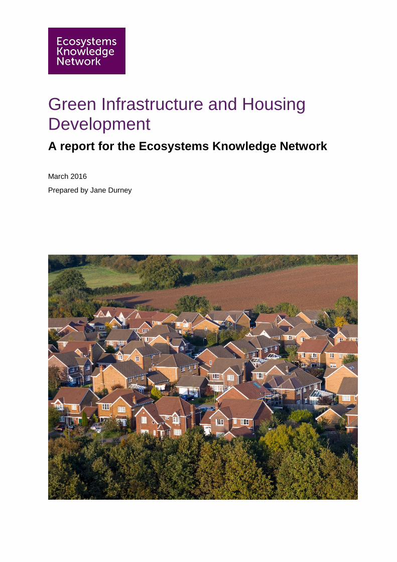
Green Infrastructure and Housing Development A report for the Ecosystems Knowledge Network
March 2016
Prepared by Jane Durney
Green infrastructure and housing development
This report has been prepared by Jane Durney.
Suggested citation: Durney, J. (2016) Green infrastructure and housing development. Ecosystems Knowledge Network. http://ecosystemsknowledge.net
The Ecosystems Knowledge Network is an award-winning resource to help people throughout the UK learn how to manage the natural environment as an asset with benefits for everyone. Our focus is on shared learning about how people's local environment underpins health, wellbeing and prosperity. The Network’s growing membership of over 2,000 professionals and volunteers represents a diverse array of interests, including public health, spatial planning, land management, water management and nature conservation. The Ecosystems Knowledge Network is a Charitable Incorporated Organisation, registered with the Charities Commission for England and Wales (No. 1159867) and the Office of the Scottish Charity Regulator (No. SC045732). Registered office: The Old Music Hall, Oxford, OX4 1JE. http://ecosystemsknowledge.net
Front cover image: © Adobe Stock
Green infrastructure and housing development
Table of Contents 1 Introduction………………………………………………………………………………….…...1
2 Research process…………………………………………………………………………….…1
3 Policy context…………………………………………………………………………….………1
4 Case studies………………………………………………………………………………..…….3
4.1 Milton Keynes .......................................................................................................... 3
4.1.1 Context – Milton Keynes………………………………………………………………….3
4.1.2 Local policy – Milton Keynes…………………………………………………………….4
4.1.3 Green Infrastructure – Milton Keynes…………………………………………………..5
4.1.4 Key benefits from the Green Infrastructure – Milton Keynes…………………………5
4.1.5 Management approach, roles and responsibilities – Milton Keynes…………………6
4.1.6 Specific findings – Milton Keynes……………………………………………………….7
4.2 Cambourne .............................................................................................................. 9
4.2.1 Context – Cambourne…………………………………………………………………….9
4.2.2 Local policy – Cambourne………………………………………………………………..9
4.2.3 Green Infrastructure - Cambourne …………………………………………………….10
4.2.4 Key benefits from the Green Infrastructure – Cambourne………………………….10 4.2.5 Management approach, roles and responsibilities – Cambourne………………….11
4.2.6 Specific findings – Cambourne…………………………………………………………11
4.3 Stamford Brook ..................................................................................................... 13
4.3.1 Context – Stamford Brook………………………………………………………………13
4.3.2 Local policy – Stamford Brook………………………………………………………….13
4.3.3 Green Infrastructure – Stamford Brook………………………………………………..13
4.3.4 Key benefits from the Green Infrastructure – Stamford Brook………………………14
4.3.5 Management approach, roles and responsibilities – Stamford Brook……………..14
4.3.6 Specific findings – Stamford Brook…………………………………………………….14
4.4 Cumbernauld ......................................................................................................... 15
4.4.1 Context – Cumbernauld………………………………………………………………...15
4.4.2 Local policy – Cumbernauld……………………………………………………………15
4.4.3 Green Infrastructure – Cumbernauld………………………………………………….16
4.4.4 Key benefits from the Green Infrastructure – Cumbernauld………………………..16
4.4.5 Management approach, roles and responsibilities – Cumbernauld………………..18
4.4.6 Specific findings – Cumbernauld………………………………………………………18
5 Overarching findings………………………………………………………………………… 20
6 Recommendations……………………………………………………………………….…….22
7 Appendix….…………………………………………………………………………….……… 23
7.1 Acknowledgements ................................................................................................. 23
7.2 The Ecosystem Approach........................................................................................ 24
7.3 UKGBC’s Demystifying Green Infrastructure top tips for ensuring success when integrating green infrastructure into projects ............................................................ 25
7.4 What does nature do for us? ................................................................................... 26
Green infrastructure and housing development
1
1 Introduction
This report reviews the long-term management arrangements for green infrastructure incorporated into ‘new’ housing developments. It focuses on the arrangements that lead to community engagement and attract further investment in the green infrastructure for the benefit of all. We were looking for evidence of the Ecosystem Approach in action and whether ecosystem services were recognised in each of the locations.
Green infrastructure refers to a network of natural and semi-natural features within and between our villages, town and cities. It includes green (soil covered or vegetated) and blue (water-covered) spaces and corridors that maintain and enhance ecosystem services1 and is capable of delivering a wide range of environmental and quality of life benefits for local communities. It ranges in scale from street trees, hedges and private gardens through to parks, rivers, woodlands and wetlands.
2 Research process
A case study approach was taken and a longlist of possible locations drawn up, from which four sites were selected. These offer a range of scale, age and location of the developments:
• Milton Keynes, England
• Cambourne, near Cambridge, England
• Stamford Brook, near Altrincham, England
• Cumbernauld, Scotland
Desktop research and telephone interviews with senior people involved in design or management of the areas were carried out to gather information about the green infrastructure, the management approaches and funding arrangements in each location, and the extent to which an Ecosystem approach or recognition of ecosystem service benefits has been used. From this information, findings were teased out and conclusions drawn as to the factors that may lead to successful design and management of green infrastructure.
The work forms part of a contract deliverable ‘Second report on how the ecosystem approach is being applied at the local and landscape scale’. The deliverable is part of a project entitled ‘Ecosystems Knowledge Network, building to encourage an ecosystems approach across the UK, making the most of our evidence and delivery on the Natural Environment White Paper Commitments’, funded by Defra, Scottish Government and the Natural Environment Research Council (BE0103).
3 Policy context
At a European level, the EU Commission describes green infrastructure as a tool for providing ecological, economic and social benefits through natural solutions and the Commission adopted a Green Infrastructure Strategy in 2013.
In England and Wales, the National Planning Policy Framework2 recognises the importance of green infrastructure in meeting the risks of climate change, flooding and coastal change. It notes the benefits of green infrastructure in conserving and enhancing the natural environment
1 UKGBC (2015) Demystifying Green Infrastructure 2 DCLG (2012) National Planning Policy Framework
Green infrastructure and housing development
2
and states that local planning authorities should ‘plan positively for the creation, protection, enhancement and management of networks of biodiversity and green infrastructure’.
Key measures in the Natural Environment White Paper3 include reconnecting nature and connecting people and nature for better quality of life. The Biodiversity 20204 strategy talks about the need to engage more people in biodiversity issues so they personally value biodiversity and know what they can do to help.
At a local level, local authority plans and strategies should set out local green infrastructure policy. This varies from place to place.
In Scotland, the National Planning Framework 3 5 emphasises the key role of green infrastructure in enhancing environmental quality and accessibility for all, helping to improve quality of life and building stronger, more resilient communities.
Scottish Planning Policy states that attention should be given to sustainable use of land, good design and the protection and enhancement of the built and natural environment, with further advice highlighting the importance of natural greenspaces in an urban open space network and the central role that green infrastructure plays in creating successful places.
The Consultation on a second Land Use Strategy for Scotland6 sets the vision for ‘a Scotland where we fully recognise, understand and value the importance of our land resources, and where our plans and decisions about land use will deliver improved and enduring benefits, enhancing the wellbeing of our nation.’ Among the three objectives is urban and rural communities better connected to the land, with more people enjoying the land and positively influencing land use.
The Community Empowerment (Scotland) Act 2015 gives communities the mechanisms to achieve their own goals and aspirations, including provisions to allow communities to purchase abandoned or neglected land in both urban and rural areas. The first Land Use Strategy (2011) highlighted linking people with the land as the necessary shift in approach to help us move towards achieving this objective.
The UK government wants to see a million new homes built in England by 20207. This represents a major opportunity to connect new communities with an understanding of the value of nature around them.
Natural England provides evidence and guidance for taking an Ecosystem Approach (see Appendix 6.2 - The Ecosystem Approach). The principles of the Ecosystem Approach could be applied to the design and management of the green infrastructure in these new developments to ensure the benefits of this green infrastructure are realised.
3 HMG (2011) Natural Environment White Paper: The Natural Choice: securing the value of nature 4 Defra (2011) Biodiversity 2020: A strategy for England’s wildlife and ecosystem services 5 Scottish government (2010) Scotland’s Third National Planning Framework - Proposed Framework 6 Scottish Government, 2015 Getting the best from our land. Consultation on a draft Land Use Strategy for Scotland 2016 -2021 7 Housing minister statement – September 2015

Green infrastructure and housing development
3
4 Case studies 4.1 Milton Keynes 4.1.1 Context – Milton Keynes
Milton Keynes is a large town in Buckinghamshire, about 45 miles north-west of London. It was formally designated as a ‘new town’ on 23 January 1967. It is the administrative centre of the Borough of Milton Keynes, a unitary authority. It covers around 89 km2 (35 square miles) with a population of ~250,0008 incorporating several old market towns and villages.
Figure 4.1.1 Milton Keynes context map
8 2011 Census: the population of the Milton Keynes urban areas, including adjacent Newport Pagnell and Woburn sands was 229,941 and that of the wider borough was 248,800.
Green infrastructure and housing development
4
When designated, planning control was delegated to the Milton Keynes Development Corporation (MKDC), wound up in 1992, 25 years after the new town was founded. Control was transferred to the Commission for New Towns (CNT) and then English Partnerships with planning responsibilities returning to local authority control with the Borough of Milton Keynes (also known as Milton Keynes Council). Between 2004 and 2011, the Milton Keynes Partnership had development control powers over designated urban development areas to drive the growth of Milton Keynes. Despite competing several times for formal city status, Milton Keynes is not a city, though it is often called one because of its scale.
Milton Keynes was originally envisaged as a ‘City in a Forest’ where parkland and green landscape was planned as a major structuring element of the layout. MKDC planned the layout of Milton Keynes with a grid pattern of approximately 1km intervals and landscaped major internal roads crossed by pedestrian / cycle bridges or underpasses between these communities. Different selections of trees and shrubs were planted in groups of grid squares to give them distinct identities. A series of linear parks running through Milton Keynes protect the flood plains of the Great Ouse and its tributaries with another green route along the Grand Union Canal. A number of large balancing lakes were created to attenuate flows of water along the main watercourses, all set in parkland. Three large blocks of ancient woodland were preserved as part of the park network as were a number of scheduled ancient monuments, mostly sites of deserted medieval villages. Central Milton Keynes includes a large park: Campbell Park.
There have been recent urban expansions planned and underway to the north, west, east and south east. The planning of some of these new districts departed from the grid model with less separation of pedestrians from main roads and fewer underpasses, although this concept is being returned to in the forthcoming south east expansion areas.
4.1.2 Local policy – Milton Keynes
Milton Keynes is developing a new Local Plan: Plan:MK: between January and April 2016, Milton Keynes Council consulted on ‘Plan:MK Strategic Development Directions9’. This will lead to a vision and development strategy for Plan:MK. The consultation document identifies areas for possible green space and linear park extensions.
The Local Plan (2005) outlines detailed policies used in assessing planning applications while the Core Strategy (2013), which conforms to the National Planning Policy Framework, provides strategic planning policy for Milton Keynes up to 2026. The Core Strategy states ‘the multi-purpose green infrastructure network should be extended into any major new development areas to continue the leisure and water management benefits… Linear parks should be extended into the development where possible to provide recreational, walking and cycling links within the development area and to the city’s extensive green infrastructure and redway network.
A Green Infrastructure Plan 10 for Milton Keynes was published in 2008 and Green Infrastructure by Design11 was produced in 2010 as a guide for sustainable communities in Milton Keynes South Midlands.
Milton Keynes Core Strategy 2013 states: ‘The Green Infrastructure Plan identifies areas of opportunity to take into account in development frameworks for Strategic Land Allocation and any sites identified through the Plan:MK. This will help to identify green buffers around the city and nearby adjacent settlements, as extension of the city’s linear parks. Delivery will be by MKC, MK Parks Trust, Internal Drainage Board and the Environment Agency. The Joint Environmental Team developed a rolling programme of work (the Environment and Open 9 Milton Keynes Council, Plan:MK Strategic Development Directions Consultation Document, Jan - April 2016 10 Milton Keynes Council (2008) Milton Keynes Green Infrastructure Plan 11 Milton Keynes South Midlands (2010) Green Infrastructure by Design
Green infrastructure and housing development
5
Space Delivery Plan) and a clear implementation strategy as a basis for committing Tariff monies in conjunction with funding from other sources.’
Green infrastructure requirements have been written into the development briefs for the urban extensions and require continuity of parks from the existing layouts: ‘Green infrastructure will be protected and enhanced. Open space will be provided in line with the Council's standards. The existing linear parks system along the Broughton, Caldecotte and Loughton Brooks will be extended into the urban extensions and along the Ouse and Ouzel Valleys to the north to provide multi-purpose green infrastructure that:
a) is attractive
b) is safe and well used for recreation
c) meets the needs of existing and future residents.’
4.1.3 Green Infrastructure – Milton Keynes
The 2013 Core Strategy describes green infrastructure and open space as a key feature of the city, with high levels of good quality accessible spaces giving Milton Keynes its unique character. Linear parks, mostly along the river valleys through and along the northern edge of the city, serve as multi-purpose green space, primarily providing flood storage as well as recreational facilities, biodiversity and an attractive setting for adjacent development.
The green infrastructure in Milton Keynes includes river valleys, woodlands, lakes (balancing lakes and restored gravel quarries), grazing land and landscaped transport corridors. As of 2006, the Milton Keynes urban area has around 20 million trees. Hedges were planted to soften the built environment or retained as former field boundary features.
There is a network, known as the ‘redways’ because of its red tarmac surface, approximately 125 miles (200 km total length) of cycle and pedestrian routes. Originally intended to segregate cycle and pedestrian traffic from vehicles, it is mainly used for leisure cycling rather than commuting, perhaps because the route is shared with pedestrians and meanders rather than taking the shortest or quickest route. The city’s park network in the care of The Parks Trust contains about 140km of surfaced ‘leisure routes’ which as well as providing a means of access to the parklands also serves as part of the strategic movement network for pedestrians and cyclists.
Milton Keynes currently has no internationally designated sites (Special Protection Areas, Special Area of Conservation, Ramsar Sites) and has two plus part of a third, Sites of Special Scientific Interest. This is below the national average both in number and by total SSSI area.
4.1.4 Key benefits from the Green Infrastructure – Milton Keynes
Milton Keynes’ green infrastructure helps with flood management as well as providing opportunities for recreation and biodiversity. Health walks take place in a range of Milton Keynes parks and open spaces. Forest Schools take place in two of The Parks Trust woods: Howe Park Wood and Shenley Wood.
The linear parks and wider green infrastructure contribute to quality of life for residents of Milton Keynes, improving health and wellbeing through opportunities for formal and informal recreation.
Linear parks may also act as green buffers between existing settlements and development sites and the green infrastructure provides wildlife corridors, linking with wider ecological networks. They have also preserved historic sites, including deserted medieval villages and surrounding tracts of ridge and furrow.
Green infrastructure and housing development
6
Air pollution levels have been found to be lower at Milton Keynes than in other similar-sized settlements12. This may be attributed to the tree-lined grid roads and large number of trees throughout Milton Keynes.
4.1.5 Management approach, roles and responsibilities – Milton Keynes
As the Milton Keynes Development Corporation (MKDC) was being wound up in 1992, it set up The Parks Trust as an independent charitable body to take over management of Milton Keynes’ major parks and landscaped roads on a 999 year lease granted by the MKDC with the freehold of the land transferred to Milton Keynes Council subject to The Parks Trust’s lease. The Trust was established with a £20 million endowment (in the form of commercial properties) which the Trust has grown to a value of £95 million13, the income from which pays for its activities. The Parks Trust is the charity that cares for many of the city’s parks and green spaces, including river valleys, woodlands, lakes, grazing land and landscaped corridors through which the major roads run. This strategic green infrastructure amounts to over 2,000 hectares (~20% of the new city area). The Parks Trust’s charitable objects are:
• To provide, maintain and equip parks, gardens, landscaped areas, woodlands, open spaces, playing fields, playgrounds and recreational amenity spaces within the Borough of Milton Keynes and the environs thereof, for the benefit of the inhabitants thereof.
• To advance public education in the area of benefit, with particular regard to horticulture, arboriculture, wild plants and wildlife.
• To provide or assist in the provision of facilities for recreation or other leisure time occupation in the interests of social welfare and with the object of improving the conditions of life for the inhabitants of the area of benefit.
In the early years of developing the new city, trees and shrubs were planted at high densities to create an attractive landscape. Large numbers were fast-growing plants. The Parks Trust management approach aims to develop a mature and well-structured landscape. In woodland areas – both ancient woodlands and new town plantations - a traditional approach to woodland management has been adopted with a combination of thinning and coppicing. Many plantations are managed under a ‘coppice with standards’ regime, traditional of lowland England.
The Parks Trust has made a commitment to biodiversity 14 and aims to maximise the biodiversity of its parks and greenspaces, balancing this with recreational, amenity and landscape needs. There is a Biodiversity Action Plan with 10 habitat action plans and 15 species action plans. These guide the land management activities of The Parks Trust. Other routine activities include grass cutting, litter picking and shrub pruning. Work is undertaken by contractors as well as direct employees. The Parks Trust has partnered with a farmer with sheep and cattle being used to graze pastures and to use hay from traditionally-managed meadows in the parks. A profit share arrangement provides an additional small income stream. Much of the Trust’s land is entered into a ten year Environmental Stewardship Scheme agreement with Natural England.
Milton Keynes Council mows council-managed public land and rural road verges. Local parish councils are responsible for manging local green spaces and play areas. As the local plan is developed and development areas are brought forward, the Council will work with The Parks
12 Milton Keynes Council. http://www.milton-keynes.gov.uk/environmental-health-and-trading-standards/pollution/local-air-quality-management Date accessed: 29 February 2016 13 The Parks Trust Annual Report and Financial Statements 2014/15 14 The Parks Trust 2010 Our Commitment to Biodiversity http://www.theparkstrust.com/downloads/wildlife/Our%20Commitment%20to%20Biodiversity%20Dec%202010.pdf
Green infrastructure and housing development
7
Trust on the delivery and maintenance of parks and open spaces associated with new development.
Gallagher Estates is the major landowner / developer in the urban extensions to the east and west. Their business is to obtain outline planning permission, put in primary infrastructure and then sell development parcels to house builders, mostly the large national companies such as Taylor Wimpey and Barratt Homes. Some of the primary infrastructure includes sustainable urban drainage systems in the form of balancing lakes and attenuation basins. Other forms of green infrastructure such as local parks and play areas are allocated, as planning obligations, for the house builders to provide. The developers are then required to transfer the green and blue infrastructure to adopting bodies, which, if it is The Parks Trust, require payment of an endowment to cover future maintenance costs.
4.1.6 Specific findings – Milton Keynes
Education and engagement
A 2015 survey15 of residents by The Parks Trust found the main reasons for visiting Milton Keynes’ parks were: going for a walk, walking the dog, visiting children’s play areas, going on an outing with friends or family or chilling / relaxing. 63% found the parks to be inspirational: well kept, beautiful, peaceful, green spaces. The most important aspects of the parks were found to be the rivers and lakes, just ahead of woodlands, grassy glades and clearings, fields and meadows. Formal landscaping and flower beds were regarded as slightly less important. Survey respondents were mostly aware that The Parks Trust was responsible for landscaping and maintenance and putting on events and activities, and, to a lesser extent, providing volunteering activities, environmental education working with local schools, and community rangers patrolling and engaging with the public.
In the early years of the life of The Parks Trust, it focused primarily on land management. Over the past decade, by careful management and growth of its endowment funds, it has been able to focus more resources on community engagement activities. The number of people using the parks have grown during this period. The Trust has a strong and growing group of volunteer supporter plus there are a number of ‘Friends of’ groups for local parks and nature reserves which help with management, activities and consulting with the local community in those areas.
The Parks Trust has environmental education as one of its objectives and since 2007 has engaged regularly with 120 local schools. At every Key Stage, each child will take part in an activity with The Parks Trust. This helps to establish a link with the natural environment and over time could help reduce anti-social behaviour in parks and greenspaces as the children grow up.
One challenge in Milton Keynes, in common with any place where there are large numbers of new homes, is the churn in population with new people moving to the area. This means that messages about events and litter need to be continually promoted to residents. The ethnic mix in Milton Keynes has been changing and The Parks Trust is planning a diversity project to engage black and minority ethnic communities with the green spaces in Milton Keynes.
The Parks Trust manages a large area of land and has to work with many different communities and a diverse range of stakeholders. While it has successfully managed its endowments to give it financial security and stability, it doesn’t have sufficient resources to do everything it wants to do. It has to keep up with rapid changes in the city and continually reach new people moving to the area. While many people know about The Parks Trust, as evidenced by the residents’ survey, they don’t necessarily know the extent of what The Parks Trust does.
15 The Parks Trust 2015 Research Market Research Report
Green infrastructure and housing development
8
The Parks Trust is moving towards engaging communities within their community rather than relying on people coming to their Parks.
Flood management
Milton Keynes’ green infrastructure plays an important role in alleviating flood risk as outlined in the green infrastructure section above. The parkland contains large strategic balancing lakes such as Willen and Caldecotte lakes. These attenuate the flows of water along the Ouzel which receives surface water run-off from the urban area of Milton Keynes. There are also local sustainable urban drainage systems such as the one that serves the Oxley Park development in western Milton Keynes which The Parks Trust has adopted.
The important role of the green infrastructure in reducing flood risk is not necessarily fully understood by residents. There has been some flooding but this was found to be due to a culvert being blocked.
Funding arrangements and governance
The Parks Trust’s independent funding arrangements enable it to take a long view in terms of managing the green spaces in Milton Keynes. In addition to income from its commercial property endowment and investments, it also generates income from events, education activities, timber sales and even sales of the livestock from its farming enterprise that maintains the pastures and hay meadows in its parks. Its constitution enables it to apply for grants which it has done with some success. The Parks Trust provides a function in Milton Keynes that elsewhere is often the remit only of the local authority.
The Parks Trust has carried out an innovative project16 in the Ouse Valley Park at Old Wolverton. It’s the first project of its kind where planning permission was granted for mineral extraction, specifically to create a new area of floodplain forest. Income from the gravel extraction is held in a special fund for the creation of the floodplain forest habitats, provision of facilities for public access, and for future maintenance of the site. A follow-on project to extract further reserves of gravel from a nearby site in the Ouse Valley, which will also be restored to provide wetland and meadow habitats, has provided the Trust with the funds necessary to purchase and secure the long term future of an established nature reserve and environmental study centre at Linford Lakes.
Several of the interviewees felt that The Parks Trust provides an excellent model for delivery, protection and maintenance of green infrastructure. The Parks Trust is a charity and company limited by guarantee. It is governed by an independent Board of Trustees and its single purpose and financial independence means that it is not subject to changing or competing priorities and can plan for the long term whereas local authority parks and landscape services have faced significant budget cuts in recent years, with more likely to come.
Future development
Milton Keynes’ green landscape is seen as contributing to the quality of life for people who live and work there: ‘it is an attractive place to move to’. Much of the green infrastructure that can be seen in and serves Milton Keynes today is the product of the new town plan and the delivery arrangements of the Milton Keynes Development Corporation and its successor bodies. These took a large-scale strategic approach to planning and infrastructure delivery with an emphasis on green landscaping in shaping the structure and character of the city. However the planning, development and infrastructure arrangements for Milton Keynes are now different. As in most other towns and cities, the local authority is now the sole planning authority and most development is led by commercial developers. The new local plan is currently being developed and will need to balance the delivery of further growth with the key tenets of landscaped grid roads and extensive linear parks that are a key part of Milton Keynes’s identity, otherwise
16 Floodplain forest: http://www.theparkstrust.com/parks/floodplain-forest (Accessed: 8 March 2016)
Green infrastructure and housing development
9
there is a risk that future developments will be less well-served by green infrastructure than the established areas of the city.
A further risk is that lack of continuity in the planning and delivery process, where several agencies and bodies are involved in planning and delivery of developments and the supporting infrastructure, as opposed to a single organisation such as a development corporation, may present challenges in ensuring a joined-up network of green space, both in terms of its physical connectivity and consistency of its management. There is a risk that if different areas of green space in and around new developments have different management arrangements, for example some areas being maintained by developer-created management companies, some by the local parish council and some by The Parks Trust, this can lead to higher combined maintenance costs through missed economies of scale, confusion amongst the public about responsibilities, and an inconsistent approach, which could be detrimental to the ecosystem function of the network overall.
Additionally, in new developments, planning obligations such as the Milton Keynes Tariff arrangements do not cover all forms of green space. This can leave open how features such as retained hedgerows, or landscaped ‘buffer’ zones or areas of ‘incidental open space’ are to be sustainably managed. It’s important for consistency and certainty for the long term that the management arrangements for these areas and the resources to do so are identified and secured.
It is clear that The Parks Trust is proud of what it does and its aim is to continue to maintain high standards of management, enhancing the greenspaces with more conservation projects and monitoring of the results. While much green space in Milton Keynes comes under the care of The Parks Trust, there is some fragmentation in the connectivity and ownership of the city’s green infrastructure, with many areas managed by Milton Keynes Council, by town or parish councils or in some new developments, private management companies. To avoid the type of risks outlined above, there is a need for a commonly recognised strategic plan for all green infrastructure, including the management of existing areas and the planning of future extensions.
4.2 Cambourne 4.2.1 Context - Cambourne
The new settlement of Cambourne on former farmland is located nine miles west of Cambridge and comprises three inter-linked villages (Greater Cambourne, Upper Cambourne and Lower Cambourne) with around 4,200 new homes. A planning application for a further 2,350 homes is under way. The local planning authority is South Cambridgeshire District Council.
In the 1990s, when plans for Cambourne were being drawn up, it was one of five sites being considered by South Cambridgeshire District Council for a new settlement. The competition to be selected as the location for development raised the quality and ambition of the proposals in terms of provision of green infrastructure.
The original development consortium at Cambourne comprised Bovis Homes, Bryant Homes, Taylor Wimpey and McAlpine (infrastructure). Planning permission was granted in 1996 and construction began in 1998. The first residents moved in in 1999 and Cambourne Parish Council was established in 2004. Development of Upper Cambourne began in 2008.
The design of Cambourne’s Green Infrastructure won two Landscape Institute Awards in 2010.
4.2.2 Local policy - Cambourne
As at the end of February 2016, the Planning Inspectors’ examination process has been suspended to allow further work to be done on Cambridge and South Cambridgeshire Local
Green infrastructure and housing development
10
Plan 2011-3117. The Examination of the Community Infrastructure Levy (CIL) proposals are on hold pending changes to infrastructure and viability studies underpinning the local plan.
South Cambridgeshire District Council’s Landscape in New Developments Supplementary Planning Document (Adopted March 2010) sets out the local authority’s intention for green infrastructure: “Within new developments, Green Infrastructure should be a fundamental part of the design and planning process from the start, and be fully integrated with the development and its setting… The District Council strongly supports the planning, delivery and management of green infrastructure as an essential part of new development and crucial to its success. Cambourne and Trumpington Meadows are examples of the successful provision of green infrastructure as part of new developments and their settings. They show how it can deliver a number of specific objectives including sustainable drainage and flood management as well as creating attractive places and encouraging people to walk, cycle and enjoy their surroundings.”
In 2011, the Cambridgeshire Green Infrastructure Strategy 2011 18 was published. It is designed to assist in shaping and co-ordinating the delivery of green Infrastructure in the county. It followed the production of the first Green Infrastructure Strategy for the Cambridge sub-region by Cambridgeshire Horizons and partners (including South Cambridgeshire District Council) in 2006. The strategy sets out a Strategic Network of green infrastructure based on seven themes: biodiversity, climate change, Green Infrastructure gateways, heritage, landscape, publicly accessible open space and rights of way, as well as three cross-cutting / overarching issues: economic development, health and well-being, and land and water management. The Strategic Network provides a county-wide framework on which to provide or enhance green infrastructure in Cambridgeshire up to and beyond 2031. Cambourne is one of six target areas contributing to the Strategic Network.
4.2.3 Green Infrastructure - Cambourne
The designs for Cambourne make use of the existing landscape and semi-natural habitats. The planned development retained all existing habitats and included designs to connect the fragmented habitats with a ratio of 60% greenspace to 40% development. So while gardens are small, residents have access to much larger areas of green space.
The green space includes pre-existing and new woodlands, scrub, meadows, lakes, grasslands, playing fields, allotments and formal play areas. There are 12 miles of new footpaths, cycleways and bridleways, and 10 miles of new hedgerows. The retention and enhancement of the existing landscape character and habitats, together with the network of public rights of way were major drivers of the layout proposed at Cambourne.
The nature reserve at Cambourne is 90 hectares with a mixture of wetland, grassland and woodland.
4.2.4 Key benefits from the Green Infrastructure - Cambourne
The green infrastructure plays an important flood management role for Cambourne with a series of balancing lakes and attenuation ponds. The lakes and ponds that prevent flooding also provide habitats for wildfowls and dragonflies.
The greenways are well-used by people travelling to work or school, with associated benefits for resident’s health and wellbeing.
17 Local plan 2011-2031: Examination (https://www.scambs.gov.uk/local-plan-examination Date accessed: 29 February 2016) 18 Cambridgeshire Green Infrastructure Strategy 2011 (https://www.cambridge.gov.uk/sites/default/files/documents/RD-NE-020%20Main%20document.pdf Date accessed: 29 February 2016)
Green infrastructure and housing development
11
4.2.5 Management approach, roles and responsibilities - Cambourne
The landscape architects, Randall Thorp, who designed the green infrastructure, were involved during and for twelve months post-implementation before it was handed over to the relevant organisation: Local Wildlife Trust, Cambourne Parish Council or the Highways Authority.
Both the Wildlife Trust and the Parish Council input and comment on final design details and have influenced the designs, for example, the location of play areas, and open spaces that are larger and an extension of the greenways. The original management plan agreed with the local authority was quite prescriptive in terms of specific activities and length of grass in certain areas. The management plan has evolved and aims now to create landscape features such as flowering meadows, or reed beds along the balancing lakes and to manage these accordingly.
The Wildlife Trust for Bedfordshire, Cambridgeshire and Northamptonshire (the Wildlife Trust) is responsible for the nature reserve and natural greenways and areas around the balancing lakes with approximately 1.5 FTE. The Wildlife Trust provides advice to local authority planning departments and got involved with Cambourne during the 1990s, challenging some of the original proposals and influencing the proposed designs.
South Cambridgeshire local authority did not want to take on management of any of the green space at Cambourne but wanted the land managed in perpetuity. No tenant could be found for a building, originally intended to be a small hotel at Cambourne. Negotiations between the Wildlife trust, developers and the local authorities secured an agreement that the Wildlife Trust would manage the green spaces in return for office premises, initially rent-free, with full ownership after ten years.
The Parish Council is responsible for managing a number of facilities on behalf of the residents of Cambourne, including allotments, sports pitches, play areas and green spaces not managed by the Wildlife Trust. This amounts to over 80 hectares. The Parish Council also mows verges and cuts grass for several developers. It has four FTE and one part-time grounds staff. When a plot is transferred to the Parish Council, they receive a commuted sum covering the first two years of maintenance. After this, funding is provided through a parish precept, collected via council tax.
The Parish Council works closely with the Wildlife Trust when carrying out upgrade work, for example, when a footpath was upgraded, the scrapings were used in a mound to create habitat for solitary bees. In some areas, they allow grass to grow longer than was originally planned.
4.2.6 Specific findings - Cambourne
Engagement and education
The marketing for Cambourne featured the natural environment and wildlife and promoted the Wildlife Trust as a manager at the site so that residents knew they were moving into a ‘nature reserve’. Originally, all new residents were due to get two years’ membership of the Wildlife Trust paid for by the developers but this didn’t happen. Rates of membership are similar to the rest of the county which is surprising given the active role played by the Wildlife Trust with walks and events, and its prominent presence on the site. The Wildlife Trust works with the local primary school.
In terms of community engagement with the green infrastructure, it is clear from the interviewees that the extensive network of paths and greenways enables residents to engage with it through their day to day activities: walking children to and from school, walking dogs and cycling.
Green infrastructure and housing development
12
Biodiversity and other benefits
Responsibilities are clear for each element of the green infrastructure. This enables it to be managed according to the requirements of specific habitats and to meet the needs of the users of it. The natural areas are some of the most biodiverse in the local area and Cambourne has become a destination for local wildlife enthusiasts.
The benefits of the green infrastructure are becoming more evident over time:
• The water management role played by the system of lakes seems to be working well. The only known flooding was as a result of mechanical failure in a specific area of the site.
• Trees are growing well and the development is beginning to get microclimate benefits of these. This cooling effect will become increasingly important as summers become hotter; one of the likely impacts of climate change.
• The layout of the green infrastructure as greenways through the three villages provides good connectivity for wildlife and is supporting a wider range of species than originally expected with ground-nesting birds doing well: Cambourne has the largest exaltation of Skylarks in the county.
• The primary schools on site use the meadows and woodlands for field trips, introducing their pupils to wildlife and ecology at minimal or no expense.
Funding
In the early years of Cambourne, the Wildlife Trust found it difficult to obtain grants towards specific projects as it was perceived as being too new or that they should be developer-funded; also some grant-funders will not fund projects linked to developments. In recent years, the Wildlife Trust has been able to secure grant funding for specific projects as part of wider initiatives at the Trust, e.g. the West Cambridgeshire Hundreds Living Landscape Scheme, a joint project between the Wildlife Trust, local landowners, The Woodland Trust, the National Trust, the Forestry Commission, Natural England, Woodfuel East and the Farming and Wildlife Advisory Group.
The arrangement for the Wildlife Trust to occupy premises rent-free in return for managing the nature reserve and other spaces at Cambourne seemed win-win at the time; today, the Wildlife Trust would seek a cash endowment too. The staff costs have to be covered out of annual budgets and if the Trust were to pay rent, it would not necessarily occupy a similar type of building to the one it is in.
The well-established relationship between the Parish Council and developers and the Parish Council fulfilling its role as an estate manager has enabled trust to be built up. This has enabled them to enhance areas within its remit and support events and local groups for the benefit of the community. The funding arrangements for the Parish Council are not considered to be at risk because it is a specific precept and local people understand what it pays for. The total receipts grow with the number of houses. The agreements with developers have enabled the Parish Council to invest in equipment for maintenance up-front.
Early on in the life of the development when relationships and accountability were less clear, private areas in some of the early sites were put into management companies. There have been complaints about the cost and poor management of open spaces within these development plots that are not the responsibility of the Parish Council.
Green infrastructure and housing development
13
4.3 Stamford Brook 4.3.1 Context – Stamford Brook
Stamford Brook is a development of 718 homes on 28 hectares of land that belonged to the National Trust as part of the Dunham Massey Estate, near Altrincham in Cheshire.
A condition of the sale of the land in 2004 to Redrow Homes and Bryant Homes (now Taylor Wimpey) was that the development would implement a longstanding plan to restore Sinderland Brook, a canalised stream running through the site, incorporate a sustainable drainage system and the homes would be built to higher environmental standards. The lessons learned from the Stamford Brook development are summarised in Volume: Delivering Sustainable Housing – learning from Stamford Brook19.
Stamford Brook is described as: “a diverse development which aims to promote sustainable living by creating a sustainable and imaginative development of new homes in a new landscape which integrates with the surrounding environment.” The scheme won a Waterways Renaissance Award.
Trafford Council is the local authority.
4.3.2 Local policy – Stamford Brook
At the time of the sale of the land, the green infrastructure requirements proposed by the National Trust went beyond what would have been required for the site.
Trafford Local Plan: Revised Supplementary Planning Document 1 (SPD1) – Planning Obligations20 (Adopted July 2014) sets out Trafford Council’s requirements for spatial and specific green infrastructure and how the Community Infrastructure Levy will be calculated and used.
4.3.3 Green Infrastructure – Stamford Brook
The green (and blue) infrastructure at Stamford Brook comprises:
• 1.8km of restored Sinderland Brook, previously canalised. The meandering river can adjust within its own semi-natural floodplain, enhancing flood protection for the site and the existing community to the north.
• A semi-natural sustainable drainage system comprising swales and storage basins that ensure that surface water run-off into the brook does not exceed the greenfield rate for the site as a whole.
• A hierarchy of formal and informal open spaces which provide opportunity for recreation.
• Boundaries and private gardens which maximise use of native hedgerow and tree planting.
There is a community woodland on National Trust land adjacent to Stamford Brook that was planted and opened to the public in 2015.
19National Trust, Redrow, Bryant Homes (2012) Volume: Delivering Sustainable Housing – learning from Stamford Brook https://ntplanning.files.wordpress.com/2012/02/volume_delivering_sustainable_housing-2.pdf 20 Trafford Council (2014) Trafford Local Plan: Revised Supplementary Planning Document 1 (SPD1) – Planning Obligations https://www.trafford.gov.uk/planning/strategic-planning/docs/revised-spd1-planning-obligations-2014.pdf
Green infrastructure and housing development
14
4.3.4 Key benefits from the Green Infrastructure – Stamford Brook
A reduction in flood risk as a result of the realignment of Sinderland Brook and the sustainable drainage system is the primary benefit of the green infrastructure at Stamford Brook. The green infrastructure also benefits residents’ physical and mental wellbeing, with the new community woodland proving popular.
4.3.5 Management approach, roles and responsibilities – Stamford Brook
Stamford Brook (Altrincham) Management Company was set up to manage the development. Scanlans Property Management is their managing agent. They employ contractors to carry out landscape management work at Stamford Brook. This includes the development side of Sinderland Brook.
Residents pay an annual service charge to the management company. This covers provision of the Landscape Management Plan, tree replacement and planting, and maintenance.
The National Trust is entitled to hold director positions on the Management Company and attend meetings. The National Trust manages the neighbouring community woodland which opened to the public in May 2015 as well as land along its side of Sinderland Brook.
The developers were Bryant Homes and Redrow Homes. The landscape architects were TEP and hydrological consultants Haycock Associates Limited designed and implemented the connected river restoration and drainage schemes.
4.3.6 Specific findings – Stamford Brook
A condition of the sale of the land by the National Trust and their ongoing involvement with the development, participating in the management company meetings and taking on management of the neighbouring community woodland, has meant that the green infrastructure has been well established.
Apparently the developers were initially sceptical of the benefits of the proposals to realign the brook and the sustainable drainage system but seeing the increase in aesthetic and recreational value, repositioned homes in the later phases of the development to face the river as they could command a premium. This is echoed by interviewees who commented that the people living along the brook really appreciate it.
The success of the re-naturalisation the brook, linked to the sustainable drainage system, provides an alternative to the commonly held assumption that flood protection can best be achieved through harder engineering solutions to control drainage and river flow.
There were challenges in securing approval from the Environment Agency for the river restoration proposals and challenges getting the sustainable drainage system adopted by the local utility provider. The project findings stated ‘the adoption requirements of the local utility provider is an obstacle and disincentive to the implementation of sustainable urban drainage systems which makes their widespread inclusion on residential developments elsewhere in the region highly unlikely’21.
The sustainable drainage system means that surface water doesn’t enter the mains sewerage system so residents benefit from a reduction in their water bills with a lower charge for wastewater treatment.
The development at Stamford Brook illustrates that managing drainage and waterways in a naturalised way can benefit developers, residents and wildlife, rather treating these as competing interests. Evidence of Water Voles has been found along the brook.
21 National Trust, Redrow, Bryant Homes (2012) Volume: Delivering Sustainable Housing – learning from Stamford Brook https://ntplanning.files.wordpress.com/2012/02/volume_delivering_sustainable_housing-2.pdf
Green infrastructure and housing development
15
The landscape management plan prepared in 2006 is now out of date and is being reviewed and updated. The updated plan will look at options to turn some grassed areas into wildlife meadows, identify trees to be pruned or removed, and changes to routine management. There are no plans for additional green infrastructure.
The introduction of natural and semi-natural environments into an urban setting has been challenging at times, for example, grass-cutting takes place less frequently in the natural areas. This has been addressed through communication of the wildlife benefits of alternative management regimes.
In 2015, for the first time, there was a series of resident volunteer work parties to remove Himalayan balsam. This helped people get to know each other and had the added benefit of being cheaper than getting contractors to do the work. However this contrasts with anecdotal evidence that some residents feel they should not have to volunteer as the service charges they pay are to cover management of the green spaces.
A 2012 survey of stakeholders which included local residents found that 85% of respondents agreed that the landscaping of the development and the river restoration improved the local area. This is regarded as an achievement as the site was previously greenfield.
4.4 Cumbernauld 4.4.1 Context - Cumbernauld
Cumbernauld lies 14 miles north east of Glasgow. It was urbanised as a new town in the 1950s with large green spaces separating the main neighbourhoods. Its wider area covers 5,500 hectares with 55,000 residents.
The development of the Community Growth Areas south of Forest Road and around Palacerigg will see major changes in South Cumbernauld. The Community Growth Areas will provide up to 2,000 new homes.
The local authority is North Lanarkshire Council.
4.4.2 Local policy - Cumbernauld
Cumbernauld lies within the Central Scotland Green network (CSGN), an initiative launched in 2009 with the aim of transforming the environment of central Scotland to make it a more attractive place to live, visit and do business in.
The South Cumbernauld Community Growth Area was proposed by North Lanarkshire Council as a location for large scale urban expansion in the 2009 Local Plan. North Lanarkshire Council’s 2010 South Cumbernauld Community Growth Area Concept Statement22 states: “The development should contain substantial areas of high quality open space or woodland, providing formal and informal recreational opportunities, which act as focal points within the community. These should form part of a network of green spaces within the area, and should seek to connect to, and enhance, existing open spaces and woodland. Wherever practical, existing woodland and hedges should be retained or expanded and incorporated into the developments. These areas should contribute towards the aims and delivery of the Glasgow and Clyde Valley Green Network.” It also includes specific requirements relating to landscape and nature conservation with areas protected for nature conservation and recreational use, and designated as open space.
Cumbernauld Living Landscape is a partnership project launched in 2013 and led by the Scottish Wildlife Trust, North Lanarkshire Council, Forestry Commission Scotland and The Conservation Volunteers working with community partners. The Cumbernauld Living
22 North Lanarkshire Council (2010) South Cumbernauld Community Growth Area Concept Statement
Green infrastructure and housing development
16
Landscape programme aims to reinforce and expand existing green networks and reconnect the people of the town to their natural environment.
In 2015, Green Network Guidance for South Cumbernauld Community Growth Area23 was launched with the support of Scottish Wildlife Trust, North Lanarkshire Council, Forestry Commission Scotland, GCV green network and Scottish Natural Heritage. The guidance sets out the Living Landscape partnership’s vision for how the green network can be integrated into the Community Growth Areas to fulfil its potential.
4.4.3 Green Infrastructure - Cumbernauld
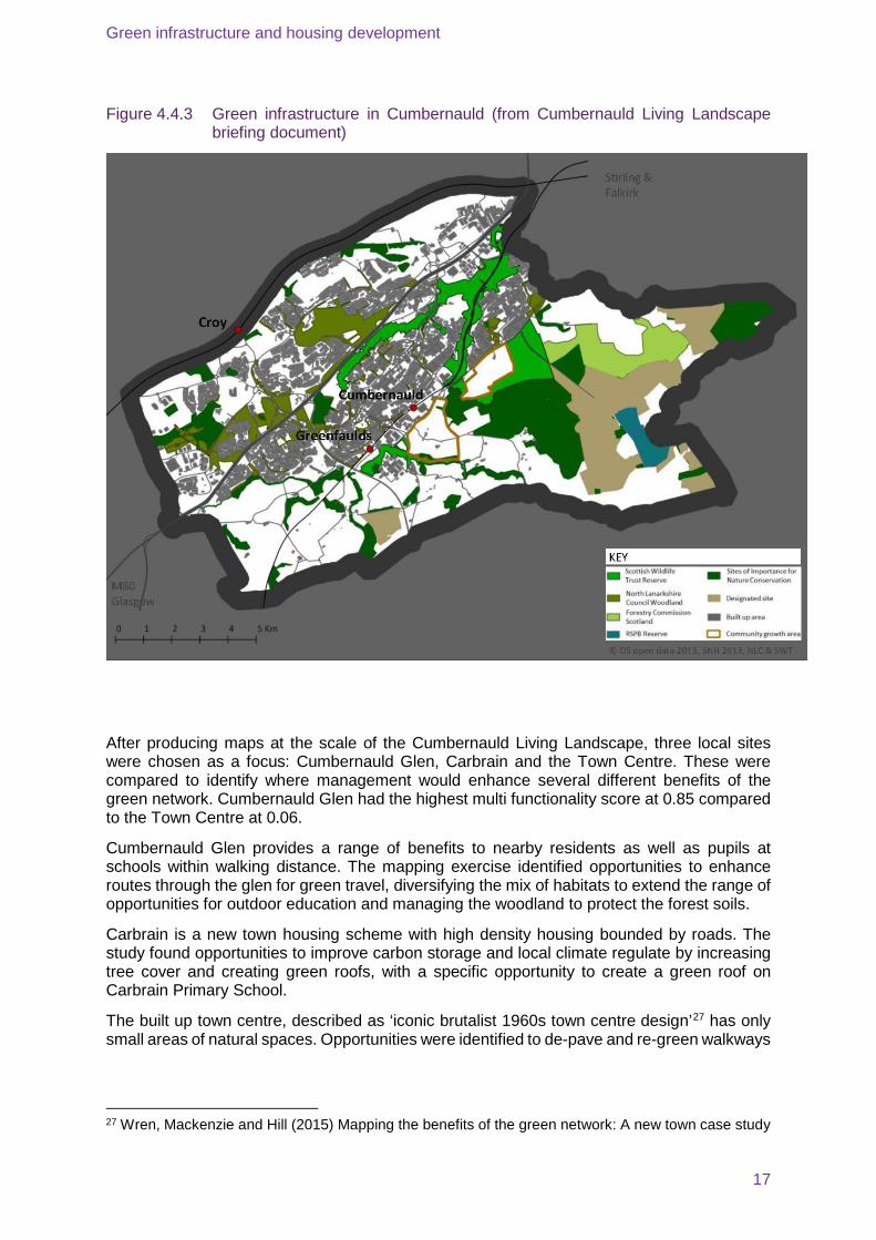
Over 50% of Cumbernauld is made up of green spaces: parks, woodlands and gardens.
The green network is a mosaic of natural and semi-natural habitats: woodlands, wetlands and natural and semi-natural grasslands. These comprise 40% of the wider areas. Amenity and recreation areas cover 14% and gardens 6% of the total area24. There is a Country Park, four Scottish Wildlife Trust nature reserves and other greenspaces (see Figure 4.4.3 on next page).
The Community Growth Area sites are adjacent to sensitive wildlife areas and three Scottish Wildlife Trust reserves.
4.4.4 Key benefits from the Green Infrastructure - Cumbernauld
Unique among the case studies for this project, a study25 mapping the benefits of nature and the green network across Cumbernauld has been carried out. The assessment used the EcoServ-GIS toolkit26 to explore the supply and demand of ecosystem services benefits in Cumbernauld.
The study evaluated nine types of benefits delivered by Cumbernauld’s green network:
• Air purification
• Water purification
• Carbon storage
• Accessible nature
• Local climate
• Education
• Noise regulation
• Green travel
• Pollination
23 Cumbernauld Living Landscape (2015) Green Network Guidance South Cumbernauld Community Growth Area http://cumbernauldlivinglandscape.org.uk/docs/083_385__southcumbernauldcga_greennetworkguidance_webversion_1446561841.pdf 24 Wren, Mackenzie and Hill (2015) Mapping the benefits of the green network: A new town case study 25 Wren, Mackenzie and Hill (2015) Mapping the benefits of the green network: A new town case study 26 EcoServ-GIS https://www.linkedin.com/pulse/ecoserv-gis-v33-available-download-jonathan-winn
Green infrastructure and housing development
17
Figure 4.4.3 Green infrastructure in Cumbernauld (from Cumbernauld Living Landscape briefing document)
After producing maps at the scale of the Cumbernauld Living Landscape, three local sites were chosen as a focus: Cumbernauld Glen, Carbrain and the Town Centre. These were compared to identify where management would enhance several different benefits of the green network. Cumbernauld Glen had the highest multi functionality score at 0.85 compared to the Town Centre at 0.06.
Cumbernauld Glen provides a range of benefits to nearby residents as well as pupils at schools within walking distance. The mapping exercise identified opportunities to enhance routes through the glen for green travel, diversifying the mix of habitats to extend the range of opportunities for outdoor education and managing the woodland to protect the forest soils.
Carbrain is a new town housing scheme with high density housing bounded by roads. The study found opportunities to improve carbon storage and local climate regulate by increasing tree cover and creating green roofs, with a specific opportunity to create a green roof on Carbrain Primary School.
The built up town centre, described as ‘iconic brutalist 1960s town centre design’27 has only small areas of natural spaces. Opportunities were identified to de-pave and re-green walkways
27 Wren, Mackenzie and Hill (2015) Mapping the benefits of the green network: A new town case study
Green infrastructure and housing development
18
and vacant or derelict land as well as create and enhance habitats and tree cover around Central Way, improving air purification, carbon storage and climate regulation.
There are forest school activities and health walks in Cumbernauld’s green spaces.
4.4.5 Management approach, roles and responsibilities - Cumbernauld
Scottish wildlife Trust took on management responsibilities for four nature reserves in Cumbernauld when the development corporation that built the new town was wound up. Scottish Wildlife Trust manages its nature reserves for the benefit of people and wildlife in line with its charitable objectives. They were given an endowment along with the land to fund its management. The Trust also plays a wider role with a programme manager playing a leadership and co-ordination role within the Cumbernauld Living Landscape partnership.
North Lanarkshire Council is responsible for management of greenspaces within the town including footpaths and green routes.
The Cumbernauld Living Landscape Partnership is aims to enhance, restore and reconnect green areas in the town, making it a better place to live in. The programme will:
• Connect, manage and enhance woodlands
• Support community activities and improve access
• Restore and manage peatlands
• Protect the town’s green network
• Influence the design of green buildings and infrastructure
• Improve water quality
4.4.6 Specific findings – Cumbernauld
Living landscape vision
More than 30 projects have been developed as part of the Cumbernauld Living Landscape project. These include a project by Scottish Wildlife Trust and Scottish Water to retrofit SuDS ponds into an industrial area on Scottish water land and within Scottish Wildlife Trust nature reserves. The Living Landscape project clearly provides a focal point for environmental projects that create or enhance habitats in Cumbernauld or connect people to them.
Engagement and education
Within Cumbernauld, there are examples of communities taking over responsibility for green spaces, and Scottish Wildlife Trust offers volunteering opportunities and school activities as part of its Natural Connections project.
The green routes through Cumbernauld are not as well used as they could be. A study was done to identify barriers to using them. These mainly relate to people’s perceptions of safety.
Constructive relationships have been developed with local planners as a result of broad stakeholder support for Cumbernauld Living Landscape Partnership as well as long term presence in the area. Scottish Wildlife Trust’s ownership of nature reserves adjacent to the Community Growth Areas adds weight to their arguments for development of the green network.
To date, there has been limited engagement with potential developers of the Community Growth Area and the real test of whether Cumbernauld gets the quality green networks that the Living Landscape vision articulates will be when the masterplan for the Community Growth Areas is issued. As with elsewhere in the UK, there is pressure to build new homes, and fast.
Green infrastructure and housing development
19
However, there is an increasing body of evidence that proximity to nature and quality green spaces can increase the value of homes, as well as improve residents’ physical and mental health. These opportunities should not be missed.
Opportunities to enhance green infrastructure
More than 50% of Cumbernauld is made up of greenspaces: parks, woodlands and gardens, but these are often disconnected and not as good for people, or wildlife, as they could or should be.
The Eco-Serv GIS toolkit provides a standardised approach to mapping the benefits of nature, ecosystem services and natural capital. The results provide evidence for planning and strategic conservation where the value of the environment can be more clearly identified and highlighted. The maps enable potential interventions to be identified and are helpful when discussing development plans with communities. In Cumbernauld, the maps have been used to plan a survey of urban greenspace and to help locate and map habitats along green travel routes. The outputs will be used as part of a Green Routes Feasibility Project that seeks to identify interventions that can be delivered to improve the function of the green network. It also provides evidence for the integration of a green network into the development of new homes in the area. Undertaking an Eco-Serv GIS assessment requires specific technical expertise. There will be CPD sessions with local planners to explain the findings.
Implementation challenges
Cumbernauld has extensive green space which formed a key part of the new town’s masterplan. However, the development corporation didn’t sufficiently consider how it would be managed, in particular the fragmentation of the design which makes it harder to manage cost-effectively, the level of maintenance required for tree shelter belts which contain some trees which have outgrown the function required of them and are vulnerable to storms.
Scotland has policies for green infrastructure that are regarded as exemplary but these lack implementation on the ground. Cumbernauld provides an opportunity to demonstrate what can be done. In particular, Scottish Wildlife Trust has carried out research28 into functional buffer zones that could be created around the Community Growth Areas. This sets out a series of design recommendations that would have a range of economic, environmental and social benefits:
• Provide ecosystem services
• Reduce disturbance of and by wildlife
• Be an area of high aesthetic and visual quality
• Support health and wellbeing
• Reduce antisocial behaviour
Cumbernauld Living Landscape’s Green Network Guidance for South Cumbernauld Community Growth Area 29 is very much a vision at this stage, albeit one with the backing of important strategic partners. Developers will be producing masterplans for the Community Growth Areas so we are at a critical point. The guidance provides them with a useful
28 Cumbernauld Living Landscape (2016) Functional Buffer Zone Best practice to protect sensitive sites http://cumbernauldlivinglandscape.org.uk/docs/083_385__functionalbufferzoneguidance_marionprofit2016_1455633047.pdf 29 Cumbernauld Living Landscape (2015) Green Network Guidance for South Cumbernauld Community Growth Area http://cumbernauldlivinglandscape.org.uk/docs/083_385__southcumbernauldcga_greennetworkguidance_webversion_1446561841.pdf
Green infrastructure and housing development
20
framework to guide the design of their developments, to integrate green networks throughout them and to enable a healthy environment for future residents.
5 Overarching findings
This report aimed to review the long-term management arrangements for green infrastructure incorporated into ‘new’ housing developments, focusing on the arrangements that lead to community engagement and further investment. We were also looking for evidence of the Ecosystem Approach in action and whether ecosystem services were recognised in each of the locations.
The 2013 State of Nature Report 30 – a collaboration between 25 UK conservation and research organisations - found that that 60 per cent of the species studied have declined over recent decades. More than one in ten of all the species assessed are under threat of disappearing from our shores. These species have declined because of loss of habitat and climate change, among other influences. It is essential that we work to restore ecosystems and degraded habitats. Current plans to build ~200,000 new homes per year will potentially have a massive impact on our natural environment. The case studies in this report show how housing development can be restorative, providing high quality green infrastructure that benefits people and wildlife. This should be a minimum requirement of all new developments.
Community engagement
This project sought examples of community engagement in green infrastructure.
There is anecdotal evidence from each of the case studies supported by The Parks Trust survey in Milton Keynes, that people appreciate living close to green space, being able to walk in it and appreciate it that it is there.
There is some engagement in the green infrastructure through volunteering where volunteering opportunities such as work parties are provided. This is the case in each of the case studies. Forest Schools and health walks take place in Milton Keynes and Cumbernauld
It is possible that the model of service charges paying for a management company to manage green infrastructure, perhaps led to less engagement by residents in the green infrastructure. This can be mitigated in cases where there is a local organisation putting on work parties or guided walks such as the Wildlife Trust in Cambourne and the National Trust at Stamford Brook.
Several of the case study interviewees mentioned challenges bringing natural areas of green infrastructure into built-up areas with it being perceived as messy, unkempt and unmanaged. They have addressed this by communicating what’s being done and why.
Green infrastructure’s role in flood management is working well in several of the case study locations though its role is not necessarily understood by local residents. Recent flood events in the UK have led again to calls for further investment in flood defences. Effective design, implementation and management of green infrastructure within and upstream of developments can play an important role.
Investment in green infrastructure
This project hoped to find examples where the management approaches led to additional investment in the green infrastructure over time. This has happened in Milton Keynes with The Parks Trust where they have been able to recycle receipts from aggregate extraction and invest them in a floodplain forest. To a much lesser extent, the Wildlife Trust in Cambourne is
30 State of Nature 2013 http://issuu.com/wildlifetrusts/docs/state_of_nature_-_main_report?e=0
Green infrastructure and housing development
21
able to secure grants and run appeals that can be invested in enhancing the green infrastructure under their control. At Stamford Brook, there is unlikely to be additional investment in the green infrastructure. The update of the landscape management plan will provide an opportunity to enhance some areas of the green infrastructure through changes to the management regimes. The neighbouring community woodland managed by the National Trust may offer some opportunities as it matures; this will be some years from now as the trees planted are still small saplings.
Achieving exemplary green infrastructure in developments
In each of the case studies, development has been or, in the case of Cumbernauld, is hoped to be used as a catalyst to secure investment in green infrastructure. In the case of Milton Keynes, it was an explicit element of the original vision: City in a Forest. It is less certain that this will continue as strongly in future development of the city. In Cambourne, the prominence given to the green infrastructure with retention of all existing habitats and a strong vision for a network of green spaces, helped secure it as a new settlement in South Cambridgeshire. At Stamford Brook, the National Trust drove the investment in green infrastructure. Green infrastructure should be seen as critical infrastructure embedded at the start of a project.
One of the people interviewed early in the process commented that where good things have been achieved in terms of green infrastructure, it was because the landowner (sometimes the Homes and Community Agency, or another government body) had accepted lower land values. This was borne out in the Stamford Brook example where the National Trust essentially funded meeting higher environmental performance and exemplary green infrastructure out of their receipts for sale of the land. To achieve this this where land is in private ownership is unlikely. It requires clear adopted local plans and policies that are enforced, as well as effective engagement by the local authority with developers if the intention set out in the National Planning Policy Framework is to be achieved.
Use of the Ecosystem Approach and other tools
We were looking for evidence of the Ecosystem Approach31 in practice, but we found that the term was not widely recognised or applied at the case study locations. The Ecosystem Approach is not well understood but some of the principles are being put into practice at the case study sites. For example:
• People: To a greater or lesser extent, each of the case studies demonstrates the involvement of people in caring for, engaging with and managing the natural environment in their area.
• Scale and dynamics: Stamford Brook demonstrates looking well into the future with the National Trust’s requirement to make allowances for climate change in designing the realignment of Sinderland Brook. The prominence of flood management as a benefit of the green infrastructure, particularly in Milton Keynes, Cambourne and Stamford Brook demonstrates working at the right geographical scale.
• Management: Cumbernauld’s Living Landscape vision is rooted in its locality, with decisions and projects being led locally, as far as is practicable.
• Functions and services: Each of the case studies demonstrates balancing the demand for use and conservation of the environment.
The EcoServ-GIS analysis for Cumbernauld has been useful in identifying opportunities for enhancing the ecosystem benefits from the green infrastructure in the town. It would be interesting to see the results of its use in Milton Keynes, Cambourne and other areas. The Natural Capital Committee has produced a range of case studies illustrating the valuation of
31 See Appendix for information about the Ecosystem Approach and its twelve principles.
Green infrastructure and housing development
22
natural capital. Applying these principles may help make the case for further investment in green infrastructure and natural capital.
6 Recommendations
Recommendations for policymakers and planners
Tools such as EcoServ-GIS and the guidance provided by the Natural Capital Committee32, and other green infrastructure assessment tools can aid better decision-making by assessing the value of existing green infrastructure and where enhancements can generate the best return in terms of ecosystem benefits. The principles of the Ecosystem Approach could be applied to the design and management of the green infrastructure in these new developments to ensure the benefits of this green infrastructure are realised.
In order to secure the benefits of green infrastructure into the future, in every area, there should be an assessment of the state of the green infrastructure and the opportunities identified to enhance and connect with it. New development proposals should be required to demonstrate how the landscape proposals connect with wider ecological networks and help to make these more resilient.
To ensure that communities have the opportunity to engage with their local green spaces in new areas, development proposals should include plans for how the long term management proposals will lead to greater community engagement and further investment. The case studies outlined show a number of ways in which this might be achieved, e.g. through establishing an independent organisation with responsibility for managing the land, such as The Parks Trust in Milton Keynes, or links to charities active locally such as the local Wildlife Trust or the National Trust.
Recommendations for developers
Green infrastructure is critical for our health and wellbeing. In summary, it is important that developers:
• Recognise the value of the natural environment and the range of benefits and
• services it provides
• Protect and enhance existing biodiversity assets
• Seek opportunities to improve habitat connectivity within sites and with ecological networks beyond development sites
• Integrate biodiversity opportunities within new development
• Make decisions informed by the best available ecological information and data
• Secure the long term management of existing and new habitats/sites 33 so that communities are engaged in the management and to enable further investment to be secured.
32 http://nebula.wsimg.com/b22fcea4b856744731e1a9d186869f5f?AccessKeyId=68F83A8E994328D64D3D&disposition=0&alloworigin=1 33 Adapted from Planning for biodiversity and the natural environment in Hertfordshire – guiding principles http://www.hertswildlifetrust.org.uk/sites/default/files/files/LNPs%20guiding%20principles%20for%20LPAs%20final%20paper%2020%2002%2014.pdf
Green infrastructure and housing development
23
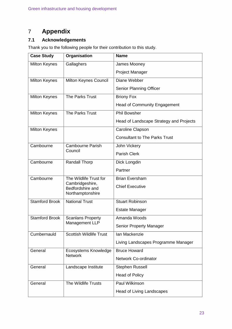
7 Appendix 7.1 Acknowledgements Thank you to the following people for their contribution to this study.
Case Study Organisation Name
Milton Keynes Gallaghers James Mooney
Project Manager
Milton Keynes Milton Keynes Council Diane Webber
Senior Planning Officer
Milton Keynes The Parks Trust Briony Fox
Head of Community Engagement
Milton Keynes The Parks Trust Phil Bowsher
Head of Landscape Strategy and Projects
Milton Keynes Caroline Clapson
Consultant to The Parks Trust
Cambourne Cambourne Parish Council
John Vickery
Parish Clerk
Cambourne Randall Thorp Dick Longdin
Partner
Cambourne The Wildlife Trust for Cambridgeshire, Bedfordshire and Northamptonshire
Brian Eversham
Chief Executive
Stamford Brook National Trust Stuart Robinson
Estate Manager
Stamford Brook Scanlans Property Management LLP
Amanda Woods
Senior Property Manager
Cumbernauld Scottish Wildlife Trust Ian Mackenzie
Living Landscapes Programme Manager
General Ecosystems Knowledge Network
Bruce Howard
Network Co-ordinator
General Landscape Institute Stephen Russell
Head of Policy
General The Wildlife Trusts Paul Wilkinson
Head of Living Landscapes

Green infrastructure and housing development
24
7.2 The Ecosystem Approach
Source: http://ecosystemsknowledge.net/ (Accessed: 26 February 2016)
The ecosystem approach is a set of 12 principles adopted by the international Convention on Biological Diversity as its primary framework for action.
The 12 principles can be broken down into four groups: people, scale and dynamics, management and functions and services:
People
The care of nature is a shared responsibility for all of society.
Value all knowledge and perspectives
Involve more of society in decisions
Scale and dynamics
Work at the right geographical scale and timescale.
Look well ahead into the future.
Work with inevitable environmental change.
Management
Allow decisions to be led locally, as far as practicable.
Assess the effect of decisions on others.
Consider economic factors.
Functions and services
Maintain the flow of ecosystem services.
Work within the capacity of natural systems.
Balance the demand for use and conservation of the environment.
Green infrastructure and housing development
25
7.3 UKGBC’s Demystifying Green Infrastructure top tips for ensuring success when integrating green infrastructure into projects
• Allocate budget within the overall development for green infrastructure design prior to land purchase.
• Specifying green infrastructure requirements into the standard engineering specifications to ensure it gets considered. Making the information as clear and detailed as possible makes for accurate costings, reducing the likelihood of elements of such as green infrastructure being value engineered out.
• Have clarity of vision for the overall scheme and have an understanding of how green infrastructure can add value. There needs to be a culture which fully embraces green infrastructure at the masterplan stage.
• Consider the design early on in the process. This should be from ‘Strategic Design’ and follow through to concept and detailed design through the RIBA stages.
• Having a biodiversity / green infrastructure ‘champion’ on major developments helps to protect green infrastructure from value engineering and ensures that what was designed gets implemented.
• Ensure the green infrastructure for the project is kept on the agenda for all key design team meetings to ensure it is always kept in mind. It’s important for everyone on the team to understand why certain features have been included and to be fully aware of their role in terms of implementing the design.
• Ensure that the appropriate and relevant level of expertise, tailored to each project, is involved at the appropriate time (usually as early as possible). The importance of having the right expertise on the project is critical in ensuring the right outcome.
• Ensure any seasonal constraints relating to the design or plant type have been factored into the implementation plans.
• Another way to help prevent green infrastructure falling off the radar during construction is to register the project with an appropriate certification scheme, e.g. BREEAM, CEEQUAL, The Wildlife Trusts’ Biodiversity Benchmark.
• Identify clear responsibility for the landscape management during the construction phase and on completion. Identify a clerk of works roles and responsibilities for the construction phase to ensure skilled people are on the ground providing implementation advice.
• Ensure a green infrastructure management plan is handed over to the individual or team maintaining the area going forward.
• Developing strong and mutually beneficial relationships / partnerships with local partners such as The Wildlife Trusts can assist in design, delivery and speedy approvals through planning. Local partners such as The Wildlife Trusts and the RSPB can help to promote the benefits of the green infrastructure to customers and to the local community, generating interest and excitement through community days, butterfly walks, etc.
Green infrastructure and housing development
26
7.4 What does nature do for us? A summary of nine benefits for us from nature, extracted from Mapping the Benefits of the Green Network: A New Town Case Study (Cumbernauld)
• Air purification – trees and woodlands in towns and cities help to clean the air by absorbing air pollution chemicals and particulate matter.
• Water purification – wetland vegetation and woodland close to streams helps to prevent polluted run-off water from causing aquatic pollution.
• Carbon storage – growing vegetation and developing soils remove carbon from the atmosphere, helping to slow climate change.
• Accessible nature – greenspaces near to where people live provide opportunities for active and quiet recreation, leading to healthier local communities.
• Local climate – trees and vegetation help to cool urban areas through shading and evapotranspiration.
• Education – greenspaces provide opportunities for learning and education, informally via observation or formally as part of school visits and outdoor education.
• Noise regulation – trees and vegetation help to absorb and diffuse noise pollution.
• Green travel – greenspaces can provide safe, traffic and pollution-free travel routes, encouraging active travel to schools or town centres.
• Pollination – semi-natural habitats, linear habitats and woodland edges provide feeding and nesting sites for wild pollinators which help pollinate crops.