great routes in the middle ages - 4vsk.jelgava.lv · the first french pilgrims heading for santiago...
TRANSCRIPT

GREAT ROUTES IN
THE MIDDLE AGES
LATVIA
FRANCE
SPAIN
ITALY
POLAND
GREECE
LEGEND

FRANCE
The Champagne
FairsSalt Route -
Guerande
The Wine
Route - Sea
The Route St
Jacques
The Wine
Route - Land
Saint Michael’s
Route
The Salt Route
– Camargue

ROUTE DE SAINT
JACQUES
VIDEO TEXT PICTURE WEBLINK HOME

ROUTE DE SAINT
JACQUES
VIDEO TEXT PICTURE WEBLINK HOME
The first French pilgrims heading for Santiago de Compostela probably
made the journey to Spain in the middle of the 11th Century, but it only
became really popular for overseas pilgrims in the 12th Century.
Pilgrims from France would have used the guide: “CODEX CALIXTINUS”
– named after Pope Callixtus II – to trace their routes to Spain.
France offered freedom of passage, so it became a popular route for
pilgrims from other European countries, and the tourist industry became
widespread on these routes as the traders looked to benefit from the
passing commerce.
For many, the pilgrimage offered a route of penance, where people would
atone for their sins by walking to Santiago de Compostela.

SAINT MICHAEL’S
ROUTE
VIDEO TEXT PICTURE WEBLINK HOME

VIDEO TEXT PICTURE WEBLINK HOME
The legend surrounding the Sanctuary of San Michele in Gargano, Puglia in
Southern Italy proved to be an inspiration for the Mont Saint Michel in
Northwestern France. Both are attributed to Saint Michael’s apparition, telling a
local priest to build a chapel on top of the mountain.
Kings, Popes and Emperors all travelled the route to Gargano on their way to
Jerusalem.
There is even an extension of this route to cover Saint Michael’s Mount in
Penzance, which the Normans had built after conquering England.
The Archangel Saint Michel became known as a guardian angel, and many
chapels were dedicated in his honour in many countries across Europe.
SAINT MICHAEL’S
ROUTE

SALT ROUTE -
GUÉRANDE
VIDEO TEXT PICTURE WEBLINK HOME

VIDEO TEXT PICTURE WEBLINK HOME
Guérande salt has a very long history, having been harvested on the
peninsula since the Iron Age. The first salt works to use the storage
capacity of the lagoon goes back to the third century, shortly after
Roman conquest.
The real inspiration behind the use of salt marshes came from the
monks from Landévennec Abbey, who, in 945, founded Batz Priory
in the region. By studying the tides, wind and sun, the monks
mapped out a plan for the salt works, which still exists today. An
enormous, laborious project, this open-air factory brought prosperity
to Guérande for many centuries and opened up the first trading
routes in Europe, becoming the “Eldorado” of Brittany.
SALT ROUTE -
GUÉRANDE

VIDEO TEXT PICTURE WEBLINK HOME
SALT ROUTE -
GUÉRANDE

VIDEO TEXT PICTURE WEBLINK HOME
Salt production and trading has been carried on in Beyond
for two thousand years. Salt from the "salines" in the
Camargue was transported by boat along the
Mediterranean coast, and then inland through the
mountains by mule. The routes often avoided the main
roads so as to avoid the "brigands".
The main purpose of the salt was to act as a preservative
for meat to keep it fresh on its journeys inland.
SALT ROUTE -
GUÉRANDE

THE WINE ROUTE
VIDEO TEXT PICTURE WEBLINK HOME

THE WINE ROUTE
VIDEO TEXT PICTURE WEBLINK HOME
BORDEAUX
The history of Bordeaux wine spans almost 2000 years to Roman times when the
first vineyards were planted. In the Middle Ages, the marriage of Henry Plantagenet
and Eleonor of Aquitaine opened the Bordeaux region to the English market and
eventually to the world's stage. The name Bordeaux derives from the French au
bord de l'eau which means "along the waters" and makes reference to the Gironde
Estuary and its tributaries, the Garonne and the Dordogne rivers which play a
pivotal role in the history and success of the region.
LOIRE VALLEY
By the 11th century the wines of Sancerre had a reputation across Europe for their
high quality. In the High Middle Ages, the wines of the Loire Valley were the most
esteemed wines in England and France, even more prized than those from
Bordeaux.[3]

THE CHAMPAGNE
FAIRS
VIDEO TEXT PICTURE WEBLINK HOME

VIDEO TEXT PICTURE WEBLINK HOME
As the European economy grew during the 11th and 12th centuries overland trade between Italy
and northwest Europe increased and merchants from these regions needed to meet to
exchange their goods. During the period from the early 12th through the 13th century, this
exchange was centred mostly in the Champagne region of France, at fairs held in the towns of
Troyes, Provins, Bar-sur-Aube, and Lagny. A great deal of Flemish cloth made its way to Italy
during the 12th century via the fairs of Champagne.
The fairs of Champagne are perhaps the most famous of the medieval European fairs. They
originated during the first half of the 12th century as a centre for the sale of horses. They
developed from local markets to regional markets and finally to fairs of Europe-wide importance.
Before fairs merchants travelled on trade routes between north and south that followed the
Meuse, Saône, and Rhône Rivers. However, a more direct route between the Rhône Valley and
West Flanders later emerged. It ran from the Saône across the upland of Langres to the
headwaters of the Paris Rivers, and then north toward Lille and Arras.
THE CHAMPAGNE
FAIRS

MONT SAINT MICHEL
VIDEO TEXT PICTURE WEBLINK HOME

VIDEO TEXT PICTURE WEBLINK HOME
Legend has it that the Archangel Saint Michael arrived in an apparition to Saint
Alban, and asked him to build a chapel on the mount. He didn’t believe the
apparition, until he woke up one day with a hole in his head where Saint
Michael had pushed so hard with his finger to convince him the request was
real. The worship of Saint Michel was introduced on the Mount in 708, and it
became one of the most important places of medieval pilgrimage. Benedictine
monks started building an abbey here in the 10th century.
Withstanding the assaults of man, time and the elements. The heroic
resistance of the Mount to English attacks during the Hundred Years’ War (14th
and 15th centuries) made it a symbol of French national identity.
MONT SAINT MICHEL

LA GRANDE TRAPPE
VIDEO TEXT PICTURE WEBLINK HOME

VIDEO TEXT PICTURE WEBLINK HOME
La Trappe started life as a simple chapel in 1122, built by Rotrou II, Count of
Perche. A couple of years later, he added a monastery to the chapel, which was
ran under the Cistercian Order, and it became an Abbey.
The Hundred Years War between the British and the French was a difficult time
for the Abbey, and it was burnt and pillaged twice (in 1376 and 1465).
It took until the 17th Century for the Monastery to rediscover its former
glory.Abbot De Rance led a reform of the Cistercian Order, and the Monastery
took the name of the reform group. But during the French Revolution, the
Monastery was closed, and some of the monks were martyred.
LA GRANDE TRAPPE

TOURS
VIDEO TEXT PICTURE WEBLINK HOME

TOURS
VIDEO TEXT PICTURE WEBLINK HOME
The Saint Gatien Cathedral in Tours was built between 1170 and 1547.
Like many Cathedrals, it was rebuilt and renovated on several
occasions during its life.
Before it, there had already been a church on the site, and pilgrims
flocked to Tours on their way to Santiago de Compostela to worship
Saint Martin, whose tomb is in Tours, after he died in 397 AD.

CHÂTEAUROUX
VIDEO TEXT PICTURE WEBLINK HOME

CHÂTEAUROUX
VIDEO TEXT PICTURE WEBLINK HOME
The Abbaye Notre Dame - Déols
Déols is the “mother city” of Châteauroux.
Previously called Bourg-Dieu, many relics bear witness to its exciting
past.
The Benedictine abbey in Déols was founded in 917 by Ebbes le Noble
and among the biggest Roman churches in France. The Hundred
Years’ War then the Wars of Religion caused the destruction of the
abbey. Only one (42m high) of the Benedictine abbey’s (113m long)
seven bell towers still stands.

ÉVAUX-LES-BAINS
VIDEO TEXT PICTURE WEBLINK HOME

ÉVAUX-LES-BAINS
VIDEO TEXT PICTURE WEBLINK HOME
The St Peter/St Paul Abbey has a rich history of links to pilgrimages.
The Abbey has relics from St Marien (a Hermit, who died in 513 AD) and there was
already an important monastery in Evaux since the 9th Century AD. The church on
the site dates back to the High Middle Ages.
Like many other churches, the building suffered during the Hundred Years War
between Britain and France, who both passed through the area.
It also suffered serious damage in the 17th Century, when the ceiling support
structure collapsed, and in 1942, a fire badly damaged the roof (which had been
restored in wood…) after the previous structural problems.
It has been classified as a Historical Monument since 1841.

ST AUSTREMOINE
D’ISSOIRE
VIDEO TEXT PICTURE WEBLINK HOME

ST AUSTREMOINE
D’ISSOIRE
VIDEO TEXT PICTURE WEBLINK HOME
The Abbey takes it’s name, Austremoine, from the first Bishop of the
area who came to evangelise Gaul. It was founded in the 12th Century
for the Benedictine monks.
It took nearly 50 years to build it. The stone was taken from a quarry
some 10km away to construct the abbey. With scaffolding not invented
yet, they had to cut down an entire forest to create a wooden framework
around the Abbey whilst they were building it.
The Abbey was a popular stop for Pilgrims as the relics of St
Austremoine are in the crypt.

AIGUIHLE - LE PUY
VIDEO TEXT PICTURE WEBLINK HOME

AIGUILHE - LE PUY
VIDEO TEXT PICTURE WEBLINK HOME
St Michael’s Pilgrimage Route passes through a number of places which
are in honour of the Archangel Saint Michael.
The chapel on the spectacular Saint Michael’s Rock (Aiguilhe) in Le Puy en
Velay is a good example. In the early days, the Archangel already featured
very prominently in the artwork. But the mural paintings were not the main
reason for the interest of pilgrims. There was a statue of Saint Michael
which was more interesting, but it was destroyed in 1562 by the Protestants.
Saint Michael is said to have protected his clergy when the steeple was
struck by lightning in 1245.

BRIANÇON
VIDEO TEXT PICTURE WEBLINK HOME

BRIANÇON
VIDEO TEXT PICTURE WEBLINK HOME
In Briançon, the former Church of the Cordeliers, is one of the few remaining
relics of the Medieval Age left in the city. It was build at the end of the 14th
Century, and has a number of precious mural paintings. It survived two major
fires in the city, and was a Franciscan Monastery during it’s time – founded in
1388 and completed in 1391.
When the Popes were based in Avignon, they made sure that the room was
created, knocking down 35 houses, to give the Abbey the scale it has today.
Apart from educating, the Cordeliers also made use of the flow of pilgrimage
tourists by setting up a business to cater for their needs.

MONTE GARGANO
VIDEO TEXT PICTURE WEBLINK HOME

MONTE GARGANO
VIDEO TEXT PICTURE WEBLINK HOME
The Chapel of Saint Michael, on Mount Gargano, is the oldest known chapel
which celebrates the Archangel Saint Michael.
Much like the story of the Mont Saint Michel, the legend talks about the
Archangel’s apparitions before the Bishop of Sipontum, on a couple of
occasions, next to a cave. He asked that this cave become a place of worship.
He promised that Sipontum would be protected from the Neapolitan pagans if
he agreed to do so.
Pope Gelasius I then built a Basilica on the hill. In May 663 AD, the locals
successfully defended the mount from the Byzantine Greeks, and Saint Michael
was credited as the saviour of Mount Gargano. The day of the battle,8th May
then became a festival which Catholics everywhere celebrated.

FOUGÈRES
VIDEO TEXT PICTURE WEBLINK HOME

FOUGÈRES
VIDEO TEXT PICTURE WEBLINK HOME
Fougères was a Medieval city with a strategic position. Notably it was on the
border between Brittany and France, and the fortified city was first settled
over 2,000 years ago. The city had three thriving trades: Cloth, Tannery and
a dyeworks. It later became synonymous with shoes with cobblers
manufacturing footwear.
It’s position was important in the struggle between the Bretons, who wished
to remain independent from the French. They even built within the fortified
castle a tribunal and a town hall to ensure that they were able to govern
themselves.
During the Middle Ages, the wars of succession saw it fall into the hands of
different owners, English and French. France eventually took control in 1448
and Brittany was annexed.

LAVAL
VIDEO TEXT PICTURE WEBLINK HOME

LAVAL
VIDEO TEXT PICTURE WEBLINK HOME
Since the 12th Century, Laval has been the centre of a brotherhood of
pilgrims, mostly following the pilgrimage route to Santiago de
Compostela. It was formed by existing pilgrims who wanted to
promote the benefits of following the route to Spain as penitence.
Laval is the resting place of Saint Tugdual, Bishop of Treguier, who
was transported to Laval after a Norman invasion of Brittany in 870
AD.

LA FLÈCHE
VIDEO TEXT PICTURE WEBLINK HOME

LA FLÈCHE
VIDEO TEXT PICTURE WEBLINK HOME
The Church and Priory of Saint Thomas became a Benedictine
monastery. The town was subsequently taken over by the
Plantagenets, and by the end of the 12th Century, there were more
places of worship established. The Saint Andrew Priory was founded
in 1171 by an order of Monks from Orleans. Another Abbey (Saint
John’s of Melinais) was also built in 1180. English Archbishop of
Canterbury, Thomas Becket even visited the sanctuary.

POITIERS
VIDEO TEXT PICTURE WEBLINK HOME

POITIERS
VIDEO TEXT PICTURE WEBLINK HOME
The city of Poitiers has had a religious connection since it became the seat of
the bishop in the 4th Century. Saint Peter’s Cathedral was started on the ruins of
a Roman basilica. It was also the scene for Eleanor of Aquitaine’s marriage to
English King Henry II in 1162. The choir stalls are among the oldest surviving in
France, dating back to 1235. The building itself wasn’t actually completed until
the end of the 12th century.
During the Hundred Years War, Poitiers even became the capital of France until
the Plantagenets left Paris in 1436.
The University of Poitiers was founded in 1431. The religious wars which took
place all across France after the Reformation also badly affected Poitiers, as
there were many Calvinist converts in Poitier.

ST JEAN D’ANGELY
VIDEO TEXT PICTURE WEBLINK HOME

ST JEAN D’ANGELY
VIDEO TEXT PICTURE WEBLINK HOME
The Royel Abbey and monastery first came to exist when a chapel was
built in St Jean d’Angely to house a relic of Saint John the Baptist in the
9th Century - and was then rebuilt on three occasions after being
destroyed in the 14th, 17th and 18th Centuries.
The abbey is now a listed building (protected historic heritage site), and is
one of the main stopover points for pilgrims heading to Santiago de
Compostela.
It was restored between 1989 and 1997, so it could house the Centre of
European Culture. It now hosts seminars, conferences and workshops,
giving a new life to the buildings.

SAINTES
VIDEO TEXT PICTURE WEBLINK HOME

SAINTES
VIDEO TEXT PICTURE WEBLINK HOME
Saintes Cathedral was originally built in the 12th Century when the Bishop of
Saintes was based there, but the version we see today is considerably more
recent. Apart from the transept arm and crossing from roman times and the
cloisters from the 13th Century, a more “modern” version of Saintes Cathedral
was started as of 1450, at the end of the Middle Ages, and wasn’t completed
when the building was severely damaged by Protestants during the religious
wars in France and they had to rebuild it once more...

BORDEAUX
VIDEO TEXT PICTURE WEBLINK HOME

BORDEAUX
VIDEO TEXT PICTURE WEBLINK HOME
The Cathedral Saint Andre de Bordeaux was consecrated by Pope Urban II
in 1096. Only a wall in the nave is left over of the first building. The Royal
Gate was made in the early 13th Century, and the main part of the cathedral
was built in the 14th and 15th Centuries. It’s a national monument, and
Eleanor of Aquitaine, who was only 13 years old at the time married the
future Louis VII of France in 1137, and then became Queen herself a few
months later.
The Cathedral is a UNESCO monument on the Santiago de Compostela
pilgrimage route.

SAINT JEAN PIED-DE-
PORT
VIDEO TEXT PICTURE WEBLINK HOME
SAINT JEAN PIED-DE-
PORT
VIDEO TEXT PICTURE WEBLINK HOME
Saint Jean Pied-de-Port is a small community sitting in the French
Pyrenees, and is the starting point of the Camino Frances, the most
popular route for entering Spain and heading towards Santiago de
Compostela for pilgrims.
The city gateway is called the Porte St Jacques, and is a UNESCO World
Heritage site as it belongs to the famous pilgrimage route.
In 1177, Richard the Lionheart’s soldiers destroyed the village of Saint-
Jean-le-Vieux near to the current site we know now as Saint Jean Pied-de-
Port. The Kings of Navarre then reconstructed the town soon afterwards,
and it remained in their control until the Spanish conquest in the early 16th
Century.

PARIS
VIDEO TEXT PICTURE WEBLINK HOME

PARIS
VIDEO TEXT PICTURE WEBLINK HOME
Even if Paris is one of the largest cities in Europe nowadays, it was even
bigger back in the Middle Ages… It was the largest city in Europe and
was a centre for trade from all across the continent.
As well as being the centre for commerce, it was also a religious centre
for the country. The Gothic architectural style started life in Paris.
Like other big cities, it has a university. Paris University on the left bank
of the Seine was among the first to be set up in Europe. Paris suffered
tremendously because of the bubonic plague in the 14th Century before
the Burgundians and English took control of the city for 18 years from
1418 – 1436.

PROVINS
VIDEO TEXT PICTURE WEBLINK HOME

PROVINS
VIDEO TEXT PICTURE WEBLINK HOME
Provins developed a reputation as a flourishing fair town during the Middle Ages,
especially with the Champagne Fairs. This UNESCO World Heritage Site (since
2001)
The Trade Fairs took place once a year, and provided a commercial centre in
France for the sale of textiles, leather, fur and spices. The cloth came in from the
BENELUX countries in the north, and was processed by the dying and exporting
centres in Genoa in Italy to be shipped out from the South of Europe to customers
around the Mediterranean.
All trade was governed by a common agreement called “Lex mercatoria” and
dominated all dealings between the trading nations in the North and South of
Europe..

TROYES
VIDEO TEXT PICTURE WEBLINK HOME

TROYES
VIDEO TEXT PICTURE WEBLINK HOME
Troyes was the capital city of the Champagne region of France from the end of
the 9th Century to the time of the French Revolution.. During the Middle Ages,
it became a major commercial centre with the famous Champagne Cloth Fairs.
Troyes is also known as lending its name to “Troy Weight.” It’s a unit of mass
to measure the weight of precious metals and gemstones. The unit of
measure first appeared in 1390
In 1429, Joan of Arc won Troyes back from the Plantagenets.
Most of the Medieval Historic city centre is no longer visible In 1524, the city
was destroyed by fire,

BEAUCAIRE
VIDEO TEXT PICTURE WEBLINK HOME

BEAUCAIRE
VIDEO TEXT PICTURE WEBLINK HOME
Beaucaire is famous for its annual fair held since medieval times on the
fourth week of July. This ten day fair dates back to 1217 when the town was
granted an annual trade fair by the Count of Toulouse. This was in memory
of a famous victory against Simon de Montfort's forces in the town. At its
height this fair would attract upwards of 300,000 people and was famous
throughout the South of France.
In 1453, French King Charles VII declared that Beaucaire would become the
site of the Fair of La Madeleine which enabled trade of goods from all the
Mediterranean countries to all of France.
The Musee Auguste Jacquet in the town has an impressive display of the
history of the Beaucaire Fair.

MARSEILLE
VIDEO TEXT PICTURE WEBLINK HOME

MARSEILLE
VIDEO TEXT PICTURE WEBLINK HOME
In the 10th Century, Marseille became an autonomous port, but was controlled
by Raymond Berangar IV of Provence in 1243. There were several battles as
rivals tried to take control of this strategic location. Eventually, Charles I of
Naples took over Naples, and trade was able to resume and flourish.
However, being a strategic port, it was also the first place to introduce the
Bubonic Plague into France in 1348, and the town suffered badly until 1361.
Over 15,000 out of a total population of 25,000 died as a result.
The Aragon dynasty sacked the town in 1423, and Marseille had to wait until
the Angevins took over and made it the most heavily fortified city outside of
Paris to restore prosperity. It then changed status, when Marseille was granted
city status. The Guilds then established a privileged status to the merchants of
the city, notably the fishermen. In 1481, Marseille was absorbed into France.

LYON
VIDEO TEXT PICTURE WEBLINK HOME

LYON
VIDEO TEXT PICTURE WEBLINK HOME
The independence of Lyon in the early Middle Ages came as a result of its commercially and politically
strategic location. It had a tremendous religious significance, as historically, several Popes had been
crowned there.
Even after Phillip the Fair managed to capture Lyon and bring it into France, it remained a prosperous
commercial centre.
At the end of the Middle Ages, four annual fairs were established, bringing merchants from all over
Europe, notably from Italy. It was a major centre in the spice trade and even more importantly, the silk
trade.
Immigrants from Florence, then turned Lyon into a major financial and banking centre after Francois I
granted weaving privileges to the city, which was previously a monopoly of Italy.

RODEZ
VIDEO TEXT PICTURE WEBLINK HOME

RODEZ
VIDEO TEXT PICTURE WEBLINK HOME
During the Middle Ages, Rodez was the final destination of part of the salt
route, and the caravans of mules which transported the salt had to be
heavily guarded by the Hospitallers of the Grand Prior of Saint Gilles
(Hospitaliers du Grand Prieuré de Saint-Gilles) because of it’s high value.

MILLAU
VIDEO TEXT PICTURE WEBLINK HOME

MILLAU
VIDEO TEXT PICTURE WEBLINK HOME
The Town became a commercial hub with fairs in the Middle Ages. Trade in
fruit, salt and sheets saw Millau become a major trading post. The Knights
Templar also saw this as a good way of raising taxes with all the traders and
merchants arriving in the town from the north and the south
Other products also traded in Millau included local produce, such as
livestock, hides (animal skin) and wool.
The salt route was also important as it enabled merchants who sold meat to
preserve it whilst it was being transported.

MONTPELLIER
VIDEO TEXT PICTURE WEBLINK HOME

MONTPELLIER
VIDEO TEXT PICTURE WEBLINK HOME
Montpellier became an important trading port in the late Middle Ages, when
Frenchman Jacques Coeur established himself in Montpellier, bringing with him
a range of products which had been imported from the Middle East (Levant)
Articles such as wools, silks, mohair and carpets were all important goods for
the merchants at the time.
Montpellier’s strategic position also enabled it to act as a trade centre, linking
the South of France with Barcelona in Spain, notably during the occupation of
the Aragon dynasty. Wine was one of the main products which was sold.

CARNON
VIDEO TEXT PICTURE WEBLINK HOME

CARNON
VIDEO TEXT PICTURE WEBLINK HOME
In the 10th Century, Marguio-Carnon had its own currency and the denier
Melgorien remained the local money until the 15th Century
Its location by the sea made it an important trading post, and the salt route
enabled its economy to flourish in the Middle Ages.

AIGUES-MORTES
VIDEO TEXT PICTURE WEBLINK HOME

AIGUES-MORTES
VIDEO TEXT PICTURE WEBLINK HOME
The port of Aigues Mortes was a busy place in the Middle Ages. In the
early part of Medieval history, the town traded in Salt which was produced
from the rich salt flats in the area, and lived from the hunting and fishing
trades.
The city levied a tax (Gabelle) on salt trade, and only locals were exempt
from paying it, and they had unrestricted access to their local resources.
In the 13th century, it’s strategic position also meant that it became an
important port for those travelling on the crusades.

NANTES
VIDEO TEXT PICTURE WEBLINK HOME

NANTES
VIDEO TEXT PICTURE WEBLINK HOME
Nantes location at the mouth of the River Loire and easy access to the
Atlantic Ocean, made it an important trading location during the Middle
Ages.
Local wine produce, fish and salt were the main products exported, and
Nantes was a satellite port which linked the west of France to the
Hanseatic League via Bruges as well as Spain, Portugal and Holland.
Nantes was historically the capital of Brittany notably in the 15th Century
under Jean V, Francois II and Anne de Bretagne. The Breton King
Nominoe had captured Nantes and incorporated the city into his territory in
the 9th Century.
.

GUÉRANDE
VIDEO TEXT PICTURE WEBLINK HOME

GUÉRANDE
VIDEO TEXT PICTURE WEBLINK HOME
In the 10th Century the local monks mapped out the salt works in Guerande,
and this valuable product became an key economic source of revenue.
For many people, it’s regarded as the El Dorado of Brittany. In 1343, the
state imposed a Salt Tax (Gabelle). The tax led to lots of contraband salt
coming from neighbouring provinces, to avoid the costs of this tax.
The salt was exported by sea to the northern states, and onward to Northern
Europe.

LILLE
VIDEO TEXT PICTURE WEBLINK HOME

LILLE
VIDEO TEXT PICTURE WEBLINK HOME
Lille’s commercial life became more important after the Lille Cloth Fair
began in the 12th Century.
It became one of the capitals of the Duchy of Burgundy in the 14th
Century, Phillip the Goody, Duke of the time, turned Lille into the financial
and administrative capital of his territory.

BRUGES
VIDEO TEXT PICTURE WEBLINK HOME

BRUGES
VIDEO TEXT PICTURE WEBLINK HOME
Bruges enjoyed a strategic role in the Middle Ages, linking the Hanseatic
League in the North of Europe, with the important trade routes to the South of
Europe and the Mediterranean Sea.
It was originally a key town in the network of Trade Fairs in France and Flemish
Belgium.
After the trade fairs lost importance, it was local merchants who took control of
trade with the Hanseatic ports and the town continued to flourish.
Wool and Cloth were major produce bought and sold in Bruges. It was also a
key link to Genoa in the Mediterranean for whom Bruges became a merchant
colony.

GENOA
VIDEO TEXT PICTURE WEBLINK HOME

Genoa has one big claim to fame. Christopher Colombus was born
here. One of the biggest celebrities of the Middle Ages. The Bank of St
George has existed since 1407 and is one of the oldest institutions in
the world, and also a very important one for the development of the city.
Before the Italian Republic we know today, Genoa was a city state in its
own right. In 1098, it is believed that the ashes of St John the Baptist
were transported to Genoa. And another major artefact, a green glass
goblet, which was brought back from the Crusades, was seen by locals
as the “Holy Grail.” Not least after the Archbishop of Genoa, Jacobus
told the story of the “Holy Grail” – But Genoa was not all about iconic
relics…it’s dark history also includes a major contribution to the slave
trade. The link to the Crusades is still visible. They adopted the St
George Cross as their city flag.
GENOA
VIDEO TEXT PICTURE WEBLINK HOME

GREECE
Trade route from
Trikala to
Ioannina
Via Egnatia
Main Greek
cities of the
Byzantine
times
Despotate of
the Morea
Religious route
to Meteora
Agricultural
route to mount
Pindos
4
2
3
1

MAIN GREEK CITIES OF
THE BYZANTINES TIMES
HOME
Thessaloniki
TrikalaIoannina
Athens
Constantinople

LOCAL MAP WITH
DIFFERENT ROUTES
Ioannina
Pili
Trikala
Meteora
Local Map:
• Trade route from
Trikala to Ioannina
• Religion route to
Meteora
• Agricultural route to
mount Pindos
Map designed by Alfred
Philippson, German
geologist, in 1893. The
route remains the same
since that time
VIDEO TEXT PICTURE WEBLINK HOME

VIA EGNATIA
VIDEO TEXT PICTURE WEBLINK HOME

“DESPOTATE OF THE
MOREA”
VIDEO TEXT PICTURE WEBLINK HOME

• Our home town, is mentioned in a well known story, named
“Alexias” in which princess Anna Komnena , describes her
father’s life, who was the emperor Alexios Komnenos.
• The history of the city, follows the story of Greece: Occupied
by Philip II of Macedon, Julius Caesar, was badly damaged by
the Slavs, Saracens and Bulgarians. After the conquest of
Constantinople by the Crusaders became a province of Epirus
.
• In 1393 the Ottomans occupied the town and in 1786 the
administration of Trikala belonged to Ali Pasha of Epirus.
• The region is also of particular interest because of Byzantine
monuments.
TRIKALA
VIDEO TEXT PICTURE WEBLINK HOME

TRIKALA
VIDEO TEXT PICTURE WEBLINK HOME

• In Byzantine times, after the first fall of
Constantinople to the Fourth Crusade in 1204 AD,
various independent states emerged, among which
the Despotate of Epirus and the principality of
Thessaly.
• In 1283, the ruler of Thessaly, John I. Doukas,
founded the monastery of Porta Panagia in the area.
• The location was of strategic importance so at 1514
st Vissarion built the famous bridge that joined
Thessaly plant with the area mount Pindos
PILI
VIDEO TEXT PICTURE WEBLINK HOME

PILI
VIDEO TEXT PICTURE WEBLINK HOME

PILI
VIDEO TEXT PICTURE WEBLINK HOME

MOUNT PINDOS
VIDEO TEXT PICTURE WEBLINK HOME
• Mount Pindos is the largest mountain range in
Greece, dominates almost throughout western
Greece.
• Shepherds used to carry the flocks up on the
mountains during summer in order to find grass for
food.
• This transportation took a few days as they
travelled on foot, so they had to stay in the
countryside to rest for the night.

MOUNT PINDOS
VIDEO TEXT PICTURE WEBLINK HOME
• The transport of
goods was
usually made
with mules and
experienced
drivers, familiar
with the roads
and passages
across the
Balkan peninsula.

MOUNT PINDOS
VIDEO TEXT PICTURE WEBLINK HOME
• Besides the stonebridges the inhabitantsof the mountains inorder to facilitate theirmovementsmanufactured smallerwooden bridges.
Wooden bridge Aspropotamos Pindos.

MOUNT PINDOS
VIDEO TEXT PICTURE WEBLINK HOME

MOUNT PINDOS
VIDEO TEXT PICTURE WEBLINK HOME

MOUNT PINDOS
VIDEO TEXT PICTURE WEBLINK HOME

MOUNT PINDOS
VIDEO TEXT PICTURE WEBLINK HOME
Salvaged parts of paths
mountain trade routes
crossing Pindos.

MOUNT PINDOS. INNS
VIDEO TEXT PICTURE WEBLINK HOME
• The inns were made on some specific points of a road, to
meet the required needs of the moving people and their
animals,
• Offering a temporary rest, feed, accommodation and
especially safety.
• Typically the inns were placed in various selected areas,
away from residential areas, commercial arteries and
especially near bridges or river crossings, narrow
mountain passes, passes into individual sources and in
strategic points.

VIDEO TEXT PICTURE WEBLINK HOME
• The inn structure was mainly a rectangular two-storey
building with a fenced yard.
• Inside the ground floor of the building, there were places for
animals, food preparation room, food and accommodation.
MOUNT PINDOS. INNS

VIDEO TEXT PICTURE WEBLINK HOME
MOUNT PINDOS. INNS

• As early as the 11th century, monks occupied the
caverns of Meteora.
• However, monasteries were not built until the 14th
century, when the monks sought somewhere to
hide in the face of an increasing number of
Ottoman attacks on Greece.
• At this time, access to the top was via removable
ladders or windlass.
• Nowadays, getting up is a lot simpler due to steps
being carved into the rock during the 1920s.
METEORA
VIDEO TEXT PICTURE WEBLINK HOME

METEORA
VIDEO TEXT PICTURE WEBLINK HOME

• Ioannina , in western Greece, founded by the Byzantine
Emperor Justinian in the 6th century AD, an important city
in The Despotate of Epirus which was one of the
successor states of the Byzantine Empire established in the
aftermath of the Fourth Crusade in 1204.
• It claimed to be the legitimate successor of the Byzantine
Empire. The term "Despotate of Epirus" is, like "Byzantine
Empire" itself, a modern historiographic convention and not a
name in use at the time.
• Today is a big city with University trade and touristic interest.
One of the most notable attractions of Ioannina is the Lake
Pamvotis.
IOANNINA
VIDEO TEXT PICTURE WEBLINK HOME

IOANNINA
VIDEO TEXT PICTURE WEBLINK HOME
The "Rule of Sinan
Pasa" (9 Oct. 1430),
written in Greek,
which granted to the
citizens of Ioannina a
series of privileges.

IOANNINA
VIDEO TEXT PICTURE WEBLINK HOME
Castle of
Ioannina

• Via Egnatia was constructed by the Roman proconsul of
Macedonia Gnaeus Egnatiusin in the 2nd century BC. This is
where its name comes from.
• It was constructed in order to link a chain of Roman colonies
stretching from the Adriatic Sea to the Bosporus.
• The route, gave the colonies of the southern Balkans a direct
connection to Rome.
• It was also a vital link to Roman territories further to the east.
• It was also, Rome's main link with her empire in the eastern
Mediterranean.
• It was repaired and expanded several times but experienced
lengthy periods of neglect due to Rome's civil wars.
VIA EGNATIA
VIDEO TEXT PICTURE WEBLINK HOME

VIA EGNATIA
VIDEO TEXT PICTURE WEBLINK HOME
Remains of Via
Egnatia

VIA EGNATIA
VIDEO TEXT PICTURE WEBLINK HOME

• The city was founded as Epidamnos in the ancient
region of Illyria in 627 BC by ancient
Greek colonists.
• In the Middle Ages the city and the surrounding
coast became a Byzantine province,
• the Theme of Dyrrhachium, in the first decade of
the 9th century.
• The city remained in Byzantine hands until the late
10th century, when Samuel of Bulgaria gained
control of the city.
DYRRHACHIUM or
DURRËS
VIDEO TEXT PICTURE WEBLINK HOME

• In the 11th –12th centuries, the city was important
as a military stronghold and a metropolitan
bishopric.
• It was occupied by the Despot of Epirus Michael II
Komnenos Doukas until 1259.
• During the 1350s the Popes, increased their
diplomatic and political activity in the area, by using
the Latin bishops. The city had been a religious
center of Catholicism.
DYRRHACHIUM or
DURRËS
VIDEO TEXT PICTURE WEBLINK HOME

• It was the capital city of the Byzantine Empire (330–1204 and
1261–1453), and also of the brief Latin (1204–1261), and
later the Ottoman (1453–1923) empires.
• It was reinaugurated in 324 AD from ancient Byzantium as
the new capital of the Roman Empire by
Emperor Constantine the Great, after whom it was
named, and dedicated on May 330 AD.
• From the mid-5th century to the early 13th century, it was the
largest and wealthiest city in Europe and was instrumental
in the advancement of Christianity during Roman and
Byzantine times as the home of the Ecumenical Patriarch of
Constantinople and as the guardian of Christendom's holiest
relics such as the True Cross.
CONSTANTINOPLE
VIDEO TEXT PICTURE WEBLINK HOME

• After the final loss of its provinces in the early 15th
century, the Byzantine Empire was reduced to just
Constantinople and its environs, along
with Morea in Greece, and the city
eventually fell to the Ottomans in 1453.
CONSTANTINOPLE
VIDEO TEXT PICTURE WEBLINK HOME

CONSTANTINOPLE
VIDEO TEXT PICTURE WEBLINK HOME
• The city was also
famed for its
architectural
masterpieces, such
as the Greek
Orthodox cathedral
of Hagia Sophia,
which served as the
seat of the
Ecumenical
Patriarchate.

CONSTANTINOPLE
VIDEO TEXT PICTURE WEBLINK HOME
• The sacred Imperial Palace where
the Emperors lived.
One of the piers from the Great Palace, now in the
courtyard of the Istambul Archaelogical Museums.

CONSTANTINOPLE
VIDEO TEXT PICTURE WEBLINK HOME
The Galata Tower

CONSTANTINOPLE
VIDEO TEXT PICTURE WEBLINK HOME
The Hippodrome
And opulent aristocratic
palaces lining the
arcaded avenues and
squares

CONSTANTINOPLE
VIDEO TEXT PICTURE WEBLINK HOME
The University of
Constantinople was founded
in the fifth Century and
contained numerous artistic and
literary treasures. Before it was
sacked in 1204 and 1453,
including its vast Imperial
Library which contained the
remnants of the Library of
Alexandria and had over
100000 volumes of ancient
texts

• From the first years of the Byzantine Empire,
Thessaloniki was the second city in the Empire
after Constantinople, both in terms of wealth and
size, with a population of 150,000 in the mid-12th
century.
• The city held this status until it was transferred to
Venice in 1423.
• In the 14th century, the city's population exceeded
100,000 to 150,000, making it larger than London
at the time.
THESSALONIKI
VIDEO TEXT PICTURE WEBLINK HOME

THESSALONIKI
VIDEO TEXT PICTURE WEBLINK HOME

• One of the oldest named cities in the world, having
been continuously inhabited for at least 5000
years.
• During the early Middle Ages, the city experienced
a decline, then recovered under the later Byzantine
Empire and was relatively prosperous during the
period of the Crusades (12th and 13th centuries),
benefiting from Italian trade.
• Following a period of sharp decline under the rule
of the Ottoman Empire, Athens re-emerged in the
19th century.
ATHENS
VIDEO TEXT PICTURE WEBLINK HOME

ATHENS
VIDEO TEXT PICTURE WEBLINK HOME
• Athens is occupied
by Franks in 1205
(after the fall of
Istambul 1204) and
Parthenon is
converted in local
metropolis.
• Many churches are
built during that
period

ATHENS
VIDEO TEXT PICTURE WEBLINK HOME
Athens in 1840 painted by August Ferdinand Stademann

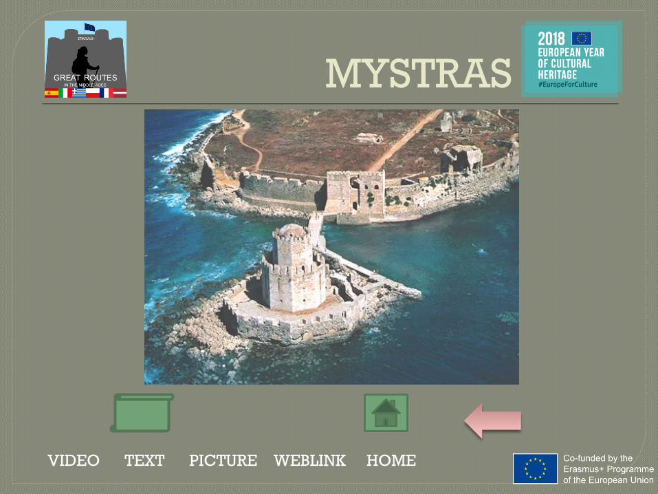
• In late 1248, William II of Villehardouin, ruler of
the Frankish Principality of Achaea,captured Monemvasia, the last
remaining Byzantine outpost on the Morea. After this success he
soon built the fortress that came to be known as Mystras.
• In September 1259, the Bysantines put an end to the Latin
Empire and restored the Byzantine Empire.
• From 1348 until its surrender to the Ottomans on May 1460,
Mystras was the residence of a Despot who ruled over the
Byzantine Morea, known as the "Despotate of the Morea". This
was the city's golden age: the place witnessed a remarkable
cultural renaissance, and attracted artists and architects of the
highest quality".
MYSTRAS
VIDEO TEXT PICTURE WEBLINK HOME
MYSTRAS
VIDEO TEXT PICTURE WEBLINK HOME

• After the Frankish conquest, Andravida became the residence of the
princes of the newly established Principality of Achaea.
• The town also became the seat of a Roman Catholic bishopric, since
1212.
• Only a few traces survive of the Frankish town, and most sources
about its buildings come from literary sources: the Church of Saint
Stephen, Church of Saint James serving as the burial place for the
princely House of Villehardouin; the Church of Saint Sophia, serviced
by the Dominicans and the largest of them all,
• Like the rest of the Principality's remnants, Andravida was conquered
by the Despotate of the Morea in the late 1420s. In 1460 it was
conquered by the Ottoman Empire and remained under Ottoman rule,
with the exception of a brief Venetian period in 1686–1715, until Greek
independence.
ANDRAVIDA
VIDEO TEXT PICTURE WEBLINK HOME

ANDRAVIDA
VIDEO TEXT PICTURE WEBLINK HOME

ITALY
La via Sacra
I Tratturi
Le Vie
Medievali

ITALY
MEDIEVAL
ROUTES
IN PUGLIA
Le Vie
Medievali
CASTEL DEL
MONTE
FALCONRY
Video
CASTEL DEL
MONTE

VIDEO TEXT PICTURE WEBLINK HOME

VIA FRANCIGENA
VIDEO TEXT PICTURE WEBLINK HOME
• The final part of Via Francigena which joined various
European Countries was the Southern Via Francigena,
which crossed part of Puglia and included the ancient Via
Appia and the Via Traiana.

VIA APPIA
VIDEO TEXT PICTURE WEBLINK HOME
• The ancient Via Appia built in 312 BC by the Censor Appio
Claudio, connected Rome to Brindisi and the
Mediterranean area with the East.

VIA APPIA
VIDEO TEXT PICTURE WEBLINK HOME
• Used both for trade and military purposes,it was considered
the main street of all communications with Rome (Queen
viarum) and used in the Middle Ages.

VIA TRAIANA
VIDEO TEXT PICTURE WEBLINK HOME
• Via Traiana, built in the second century A.D. by Emperor
Trajan, was an alternative road to Via Appia which linked
Benevento to Brindisi, crossing also Bitonto and the
Adriatic coast.

VIA TRAIANA
VIDEO TEXT PICTURE WEBLINK HOME

VIA TRAIANA
VIDEO TEXT PICTURE WEBLINK HOME
• During the Lombard times Via Traiana, part of Via
Francigena, was used by pilgrims going to San Michele
Arcangelo (Monte Sant'Angelo sul Gargano).

VIA TRAIANA
VIDEO TEXT PICTURE WEBLINK HOME

VIA TRAIANA
VIDEO TEXT PICTURE WEBLINK HOME
• The Templars and Hospitaliers built hotels and hospices for
travellers along its path and ensured the safety of the
journey.

VIA TRAIANA
VIDEO TEXT PICTURE WEBLINK HOME
• Along this road there were numerous post stations used to
take care of carriages, change horses and for travellers.

MEDIEVAL ROUTES
VIDEO TEXT PICTURE WEBLINK HOME
• During the Crusades those roads were used by armies and
pilgrims traveling to the Holy Land and throughout the
Middle Ages they were part of the great pilgrimage routes
system.

MEDIEVAL ROUTES
VIDEO TEXT PICTURE WEBLINK HOME

MEDIEVAL ROUTES
VIDEO TEXT PICTURE WEBLINK HOME
• During the Middle Ages the goods produced in Apulia were
transported along the Via Appia and Traiana: oil and other
products from Bitonto and other cities were brought to Apulian
coastal cities, such as Barletta, Bari and Brindisi.

MEDIEVAL ROUTES
VIDEO TEXT PICTURE WEBLINK HOME
• The olive oil produced in Bitonto, appreciated since the
Middle Ages for its quality, was sent by ships throughout
Europe, especially by Venetian merchants.

CASTEL DEL MONTE
VIDEO TEXT PICTURE WEBLINK HOME

FREDERICK II
VIDEO TEXT PICTURE WEBLINK HOME
• Frederick II was born in 1194. He belonged to a noble
Swabian family. Orphan at an early age he became, still
very young, king of Sicily, Emperor of the Holy Roman
Empire and King of Jerusalem.

FREDERICK II
VIDEO TEXT PICTURE WEBLINK HOME
• The emperor loved a lot Puglia as it is witnessed by the
name he was given “puer Apuliae” which means The Child
of Puglia.
• He was also known with the nickname of “stupor mundi”,
the wonder of the world, because of his extraordinary
personality.

FREDERICK II
VIDEO TEXT PICTURE WEBLINK HOME
• Frederick built a lot of castles in Puglia such as Castel Del
Monte, nice and mysterious like no other places, similar to
a crown set on the top of a hill next to Andria : the celeb
Castle is a symbol of the Swabian power.

CASTEL DEL MONTE
VIDEO TEXT PICTURE WEBLINK HOME
• The Castle was built around 1240 by local skilled workers
probably on the ruins of a previous Lombard and Norman
fortress.

CASTEL DEL MONTE
VIDEO TEXT PICTURE WEBLINK HOME
• The plan of the castle is octagonal, with eight rooms on the
ground floor and eight rooms on the first floor, to form an
octagon.

CASTEL DEL MONTE
VIDEO TEXT PICTURE WEBLINK HOME
• Eight are the imposing towers of the octagonal plan.

CASTEL DEL MONTE
VIDEO TEXT PICTURE WEBLINK HOME
• Every room has a keystone form and they overlook an
octagonal courtyard.

CASTEL DEL MONTE
VIDEO TEXT PICTURE WEBLINK HOME
• The number eight has got a holy meaning and it represents
the “mediation” between the square and the circle, between
the earth and the sky.

CASTEL DEL MONTE
VIDEO TEXT PICTURE WEBLINK HOME
• The castle was not designed to be a fortress: in fact ,
according to the experts, it is free of the typically military
elements and of moats and is not placed in a strategic
position.

CASTEL DEL MONTE
VIDEO TEXT PICTURE WEBLINK HOME
• The Swabian emperor attributed to Castel del Monte a
symbolic representation of his power and his personality:
Frederick was fond of maths, poetry, philosophy,
astronomy and falconry.

CASTEL DEL MONTE
VIDEO TEXT PICTURE WEBLINK HOME
• The whole building is full of astronomic symbols: its
position is studied so that in the days of the solstices and
equinoxes the shadows originated by the sun follow a
particular direction.

CASTEL DEL MONTE
VIDEO TEXT PICTURE WEBLINK HOME
• A further hypothesis sees Castel del Monte like a temple
dedicated to the cure of the body in line with the model of
the Arabic hammam.

FREDERICK II AND
THE ART OF FALCONRY
VIDEO TEXT PICTURE WEBLINK HOME

FREDERICK II AND
THE ART OF FALCONRY
VIDEO TEXT PICTURE WEBLINK HOME
Since his arrival in Apulia FrederickII was fascinated by hunting withfalcon. Over time it became asymbolic manifestation of hispower but also a real passion thathe cultivated throughout his life.

FREDERICK II AND
THE ART OF FALCONRY
VIDEO TEXT PICTURE WEBLINK HOME
As a scientist and a naturalist, Frederick II deepened hisresearch on birds and the art of hunting with birds of prey bysummoning skilled southern falconers and Arabs at the court.

FREDERICK II AND
THE ART OF FALCONRY
VIDEO TEXT PICTURE WEBLINK HOME
Not satisfied
by the information
given him by his experts,
he began to study
the behavior of birds directly,
up to draw up the famous treatise
"De Arte Venandi cum Avibus".

FREDERICK II AND
THE ART OF FALCONRY
VIDEO TEXT PICTURE WEBLINK HOME
The favourite placesof Frederick where hecould observe thewildlife and birds inparticular, were thelarge green areas nearFoggia, Margherita DiSavoia, Trinitapoli andMelfi.

FREDERICK II AND
THE ART OF FALCONRY
VIDEO TEXT PICTURE WEBLINK HOME
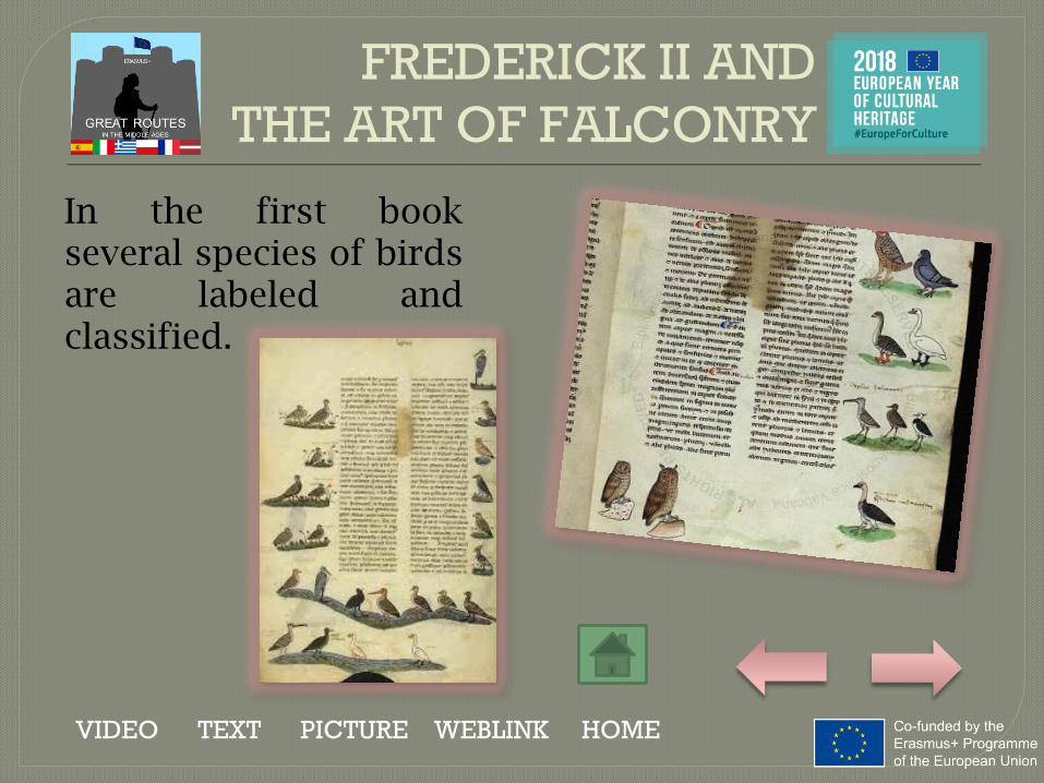
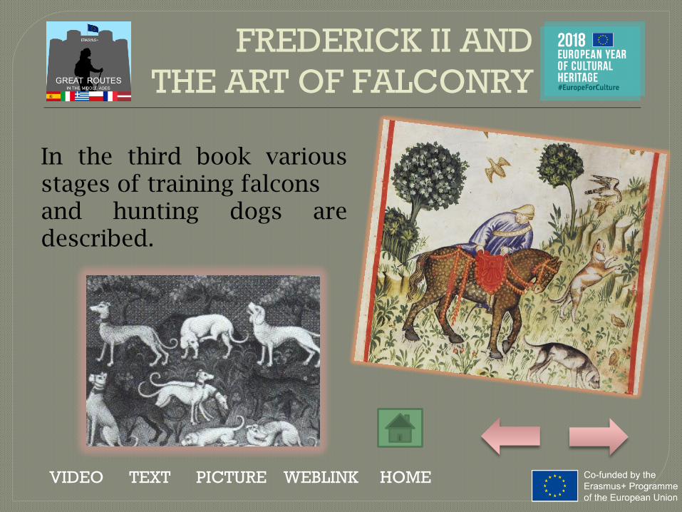
DE ARTE VENANDI CUM AVIBUSIt is a treatise on falconry based on thetechniques of breeding and trainingbirds. It is divided into 6 books.
FREDERICK II AND
THE ART OF FALCONRY
VIDEO TEXT PICTURE WEBLINK HOME
In the first bookseveral species of birdsare labeled andclassified.

FREDERICK II AND
THE ART OF FALCONRY
VIDEO TEXT PICTURE WEBLINK HOME
In the second book there is thedescription of the falconryequipment, the mode of catchingthe Falcons and their nutrition.
FREDERICK II AND
THE ART OF FALCONRY
VIDEO TEXT PICTURE WEBLINK HOME
In the third book variousstages of training falconsand hunting dogs aredescribed.

FREDERICK II AND
THE ART OF FALCONRY
VIDEO TEXT PICTURE WEBLINK HOME
In the fourth book different modes
of hunting cranes are minutely described.

FREDERICK II AND
THE ART OF FALCONRY
VIDEO TEXT PICTURE WEBLINK HOME
The fifth book deals with the training of the Saker Falcon to
hunt for the heron.

FREDERICK II AND
THE ART OF FALCONRY
VIDEO TEXT PICTURE WEBLINK HOME
The sixth bookfocuses on thehunting with theperegrine falcon towaterfowl.

FREDERICK II AND
THE ART OF FALCONRY
VIDEO TEXT PICTURE WEBLINK HOME
The original treaty was lost inthe defeat of Parma of 1248and what still survivesnowadays is a copy drawn upby his son King Manfred after1258.

ITALY
THE SHEEP
TRACKS
I Tratturi

THE SHEEP TRACK
IN PUGLIA
VIDEO TEXT PICTURE WEBLINK HOME

THE SHEEP TRACK
IN PUGLIA
VIDEO TEXT PICTURE WEBLINK HOME

THE SHEEP TRACK
IN PUGLIA
VIDEO TEXT PICTURE WEBLINK HOME

THE SHEEP TRACK
IN PUGLIA
VIDEO TEXT PICTURE WEBLINK HOME

THE SHEEP TRACK
IN PUGLIA
VIDEO TEXT PICTURE WEBLINK HOME

THE SHEEP TRACK
IN PUGLIA
VIDEO TEXT PICTURE WEBLINK HOME

THE SHEEP TRACK
IN PUGLIA
VIDEO TEXT PICTURE WEBLINK HOME

THE SHEEP TRACK
IN PUGLIA
VIDEO TEXT PICTURE WEBLINK HOME

THE SHEEP TRACK
IN PUGLIA
VIDEO TEXT PICTURE WEBLINK HOME
.

THE SHEEP TRACK
IN PUGLIA
VIDEO TEXT PICTURE WEBLINK HOME
.

THE SHEEP TRACK
IN PUGLIA
VIDEO TEXT PICTURE WEBLINK HOME

THE SHEEP TRACK
IN PUGLIA
VIDEO TEXT PICTURE WEBLINK HOME

THE SHEEP TRACK
IN PUGLIA
VIDEO TEXT PICTURE WEBLINK HOME

THE SHEEP TRACK
IN PUGLIA
VIDEO TEXT PICTURE WEBLINK HOME

THE SHEEP TRACK
IN PUGLIA
VIDEO TEXT PICTURE WEBLINK HOME

THE “MASSERIE”
VIDEO TEXT PICTURE WEBLINK HOME

THE “MASSERIE”
VIDEO TEXT PICTURE WEBLINK HOME

ITALY
La Via Sacra
THE SACRED
LINE

THE SACRED LINE
VIDEO TEXT PICTURE WEBLINK HOME

THE SACRED LINE
VIDEO TEXT PICTURE WEBLINK HOME
The mysterious
and evocative
St. Michael's Sacred Line
joins seven monasteries
dedicated to the
Archangel Michael
for over than 2 000 km
crossing Europe..

THE SACRED LINE
VIDEO TEXT PICTURE WEBLINK HOME
The seven shrines of the Sacred Line of St. Michael are:
Skellig Michael (Ireland), St Michael's Mount (Great Britain),
Mont Saint Michel (France), the "Sacra" of San Michele (Piedmont, Italy),
San Michele (Apulia, Italy)St. Michael's Monastery (Greece),
Monastery of Mount Carmel (Israel).

THE SACRED LINE
VIDEO TEXT PICTURE WEBLINK HOME
Santuario di San Michele Arcangelo,Monte Sant’Angelo - Puglia

THE SACRED LINE
VIDEO TEXT PICTURE WEBLINK HOME
This line is one of the so-called 'ley
lines', straight lines that touch
important points of the world, very exclusive places
already considered in prehistoric times.

THE SACRED LINE
VIDEO TEXT PICTURE WEBLINK HOME
They are high symbolism and spiritual places.
According to the legend, The Holy Line of St
Michael is the sword thrust that he inflicted to the
Devil to send him back to the hell.

THE SACRED LINE
VIDEO TEXT PICTURE WEBLINK HOME
The Sacred Line
is in perfect
alignment with
the sun on the
day of the
Summer
Solstice.

THE SACRED LINE
VIDEO TEXT PICTURE WEBLINK HOME
St. Michael is venerated by the Christian tradition as a defender of the Christians; represented as a warrior, he is called in defense against the enemies of the Church.

THE SACRED LINE
VIDEO TEXT PICTURE WEBLINK HOME
From the East, the
Archangel cult spread
and developed in the
Mediterranean region,
particularly in Italy,
where he arrived with
the expansion of
Christianity.

THE SACRED LINE
VIDEO TEXT PICTURE WEBLINK HOME
The Emperor Constantine I, since the year 313 showed
him a special devotion,
dedicating him the Micheleion,
an imposing shrine erected in
Constantinople.

LATVIA

HANSEATIC CITY RĪGA
VIDEO TEXT PICTURE WEBLINK
The inclusion of Riga in the Hanseatic League in 1282 would have accelerated its
development as an important trading town with vital seaward connections to Europe

Rīga was officially founded by the German Bishop Albert in 1201,
though the area was populated already long before that. Rigans themselves
originated from the ancestors of the Latvian people who settled here in the 11th
and 12th centuries. During the Middle Ages Rīga was a mighty seaport, the
largest city in the Swedish Empire during the 17th century, a leading port for the
Russian Empire in the 18th and 19th centuries, and a powerhouse centre for
commerce and trade in the entire region.
This status was facilitated by Riga’s membership in the Medieval
Hanseatic League. In the Middle Ages Riga was one of the most developed
cities in the Hanseatic League, and is still active in the International Modern
Alliance of Hanseatic cities. The Hanseatic days are remembered in Old Riga
through the historical Great Guild and Small Guild, as well as the rebuilt House
of the Blackheads – all of them artisans’ and craftsmen’s guilds in the booming
city. The House of Blackheads was built in 1334 as a meeting and celebration
hall, but a mostly German brotherhood of foreign merchants called the
Blackheads bought the building in the 17th century. Since 1999 Rigans can
again be proud of their newly reborn House of Blackheads.
Rīga in Hanseatic
League


RIVER ROUTE
DAUGAVA
VIDEO TEXT PICTURE WEBLINK

RIVER ROUTE GAUJA
VIDEO TEXT PICTURE WEBLINK

RIVER ROUTE VENTA
VIDEO TEXT PICTURE WEBLINK

PICTURE

PICTURE

PICTURE

• Daugava waterway began at Riga port at Rīdzenesriver entry, where all the goods were stored,evaluated, weighed, packaged and handled. Nextlargest commodity storage place was Koknese town,where happened to be land trade routes to Vidzeme.Daugava travel destination was initially Smolensk,Polotsk and later Vitebska.
• To guard and monitor these roads, there were builtDaugavgrīva (1305), Rīga (1201), Salaspils (1186),Ikšķile (1185), Lielvārde (1201), Aizkraukle (after1209), Koknese (1209), Altene (14. century.), Sēlpils(1373), Lakstene (1354), Krustpils (1297), Dignāja(1366), and Daugavpils (1279) fortresses.
River DAUGAVA

• Venta waterway started in Kurzeme near
Ventspils and was accessible to ships till Ventas
rumba near Kuldiga, which was an important
overland intersection. There was a project to
extend the road but it was never finished.
• To guard and monitor the road there were built
Ventspils (1290), Piltene (1309) and Kuldīga
(1242) fortresses.
River VENTA

• The ancient Gauja waterway through Turaida and Cēsis led toTartu, which at the time of Hansa was mostly used as a way totrade land with the cities of Pskov and Novgorod.
• • One branch of the road went along the Gauja to Cēsis city,from which began overland road along Rauna, Smiltene,Gaujiena and Alūksne castles to Izborsk and Pskov cities.
• • Second branch from Turaida went to Limbaži, alongBurtnieki and Rūjiena castles to Vīlande city. Third branchthrough Straupe city led to Valmiera city, further along Valkacastle to Tērbata city.
• To guard and monitor there were built Sigulda (1207), Cēsu(1209), Turaida (1214), Limbaži (1223), Valmiera (1224),Straupe (1300), Alūksne (1342), Valka (1345) and a lot ofsmaller fortresses.
River GAUJA

HANSEATIC CITY
CĒSIS (Wenden)
TEXT PICTURE

The planning of the town of Cēsis was done in the second halfof the 13th century. The marketplace with a church was in thecentre of the town. The centre of housing was the stone castleof the Livonian Order with its three fortified towers. The townwas also encircled by a dolomite stonewall with eight towersand five gates. Buildings from the medieval ages include St.John's Church(built 1281–1284), the ruins of the Order'scastle, Cēsis Castle and fortification walls, fragments of whichcan still be seen at Vaļņu iela and Palasta iela. In addition,ancient road networks and building plots have survived frommedieval times, although many of the buildings themselveshave been ruined (the last destroyed in 1748).
CĒSIS (Wenden)

PICTURE

HANSEATIC CITY
LIMBAZI (Lemsahl)
TEXT PICTURE
In ancient times, Limbaži was a Livonian settlement known asLemisele, part of Metsepole. In the early 13th century, Bishop Albertand the Teutonic knights destroyed the village while conqueringMetsepole, and built a castle, around which formed the new city,Lemsahl. Until the beginning of the 16th century, Lemsahl could bereached by seagoing vessels travelling up the Svētupe. Ships camefrom as far as Lübeck and Copenhagen to trade for honey, wax,lumber, grain, and furs. The small trading camp surrounding thecastle grew into a large town, and was admitted to the HanseaticLeague. Each year, Lemsahl hosted a conference attended by baronsfrom all over Livonia, and the city hosted at least three other fairsthroughout the year as well. During these fairs, the town may haveheld as many as 20,000 people at once. In addition, the Bishop ofRiga made Lemsahl his spring residence, which became a walled cityto protect both the bishop and the trading center. In population,Lemsahl was second only to Riga.
LIMBAŽI (Lemsahl)

PICTURE

HANSEATIC CITY
VENTSPILS (Windau)
TEXT PICTURE

Ventspils is a town in northwestern Latvia in thehistorical Courland region of Latvia, and is the sixthlargest city in the country. Ventspils developedaround the Livonian Order Ventspils Castle, builtalong the Venta River. It was chartered in 1314 andbecame an important mercantile city of the HanseaticLeague. As part of the Duchy of Courland, Ventspilsblossomed as a shipbuilding centre. 44 warships and79 trading ships were built in the town, and it was fromVentspils that the Duke's fleet set out to colonizeGambia and Tobago. Metal, amber, and wood-working shops also became important to the city'sdevelopment.
VENTSPILS (Windau)

PICTURE

HANSEATIC CITY
KULDIGA
TEXT PICTURE

Kuldīga is the pearl of Kurzeme, Latvia's western region. It is anancient town with unique, distinctive architecture. Kuldīga was firstmentioned in 1242. It joined the Hanseatic League in 1368. In the 17thcentury, Kuldīga (along with Jelgava (Mitau)) was one of the capitalsof the Duchy of Courland. The origin of the ancient town Kuldīga canbe explained by its location on the crossroads: the waterways of RiverVenta and land routes joining the Prussian lands with the lowerreaches of River Daugava. The ancient Kuldīga town of Couronians – afortified castle mound and a settlement were located 3,5 km to theNorth down the River Venta on its left bank. The castle mound can beobserved nowadays still. It is located on a bank of the River Venta onthe foreland between the deep gully of the River Veckuldīga and theancient valley of the Venta. The Site of the Castle itself is located inthe several hectare wide area, but together with the Old City ofKuldīga –the area of more than ten hectares. There might have been aport by the River Veckuldīga.
KULDĪGA (Goldingen)

PICTURE

HANSEATIC CITY
KOKNESE (Kokenhusen)
TEXT PICTURE

The site of Koknese was originally a Latgalian
and Selonian settlement named Kukenois. The
town, known in German as Kokenhusen,
received its town privileges in 1277. During the
14th century, Koknese flourished as part of the
mercantile Hanseatic League. Archbishop John
V of Wallenrodt was able to resolve the conflict
with the Teutonic Order and restore the
territory to the church in 1397.
KOKNESE (Kokenhusen)

PICTURE

HANSEATIC CITY
VALMIERA (Wolmar)
TEXT PICTURE

Valmiera and its surroundings have been one of the longest-inhabited
regions of Latvia. Archeological evidence indicates the site was inhabited
9,000 years ago. In 1224 after partition of Tālava trade roads along the
Gauja river became property of Livonian Brothers of the Sword who
erected a castle which is today known as Valmiera Castle. After the Battle
of Saule in 1236 Valmiera Castle and nearby lands became the property of
the newly established Livonian Order. Valmiera was a member of the
Hanseatic League from the 14th–16th centuries. Involvement in the Hansa
brought significant trade and movement into the town’s life. During the
14th-16th centuries several regional assemblies (landtags) were held in
Valmiera. After the Livonian War in 1583 Valmiera was heavily devastated
and was incorporated into the Duchy of Livonia as part of Wenden
Voivodeship.
VALMIERA (Wolmar)

PICTURE

POLAND
The Hanseatic
League
Via Regia
Amber Road
The Hanseatic
League river
road
Camino Polaco
HANSEATIC LEAGUE
The Hanseatic League (Hansa) was formed around the middle of
the 12th century by German and Scandinavian seafaring merchants
to protect their mutual trading interests. Since there were no navies
to protect their cargoes, no international bodies to regulate tariffs
and trade, and few ports had regulatory authorities to manage their
use, the merchants banded together to establish tariff agreements,
provide for common defense and to make sure ports were safely
maintained. The original network linked Lübeck, Westfalia, Saxony
and Gotland, but it quickly spread east with the conquest of Livonia
in the early 13th century. At its peak, the Hanseatic League covered
the entire North Sea and Baltic Sea Regions and it stretched
hundreds of miles inland along rivers from the Rhine to the Daugava.

HANSEATIC LEAGUE
Map of a Hanseatic Leagues’s Cities
Malbork

GDAŃSKGdansk is one of the oldest towns in Poland. It lies at the
mouth of the Vistula River, and as from the 10th century, the
town functions as a center for the shipping of products
produced along the river. In 1236 AD, Gdansk for the first time
obtains its municipal charter, and as from 1260 AD the town is
granted a papal patent, permitting it to hold a yearly market.
Three years later a municipal charter under the law of Lubeck
is granted, and after the city quickly becomes a member of
the Hanseatic League.
The 13th century is a time of prosperity for the town. The trade
with other Hanseatic towns increases substantially, and the
14th century gives even more growth, especially when it
comes to the amount of exported grain.


GDAŃSK
The most interesting episode of
Gdańsk’s participation in the
Hansa is the war it had with the
English king, in which Gdańsk’s
fleet participated by operating
in the North Sea at the mouth of
Thames. During that war Pawel
Beneke, the most famous sailor
from Gdańsk, on the ship called
“Peter from Gdańsk” (Peter von
Danzig) managed to win the
“Final Judgment” by Hans
Memling, the most precious
piece of art which still remains in
the art collections of the city.
„Final Judgment” by Hans Memling at the
National Museum in Gdańsk

LUBEKA-GDAŃSK-RIGAGdańsk thanks to its favorable
location which was at the
intersection of North-South and
East-North routes, had a great
commercial importance. The
economic importance of the
Vistula estuary forced Gdańsk to
expand the city and create a port.
This also led to an increase in the
activity of Gdańsk into the
Hanseatic policy and its sea routes
to Lubeka and Riga. To Lubeka
Gdańsk mainly exported grain,
ash, wax, copper, beer and
imported wine, hops, cloth, raisins,
figs, salt and pepper.
Map of the Hansetic League’s main
sea routes

SŁUPSKThe city is located in the
northwestern part of present-day
Poland, near the Baltic Sea on the
Słupia River. Słupsk had its
origins as a Slavic Pomeranian
settlement on the Słupia river in
early Middle Ages. In 1265 it was
given city rights. By the 14th
century, the town had become a
centre of local administration and
trade and a Hanseatic League
associate. Between 1368 and
1478, it was the residence of the
Dukes of Pomerania. In the
twelfth century, the town became
one of the most important
castellanies in Pomerania
besides Gdańsk and Świecie.
The town Hall

SŁUPSK
The defensive walls of the town

KOŁOBRZEGKołobrzeg is a city in the West Pomeranian Voivodeship in
north-western Poland. During the Early Middle Ages, Slavic
Pomeranians founded a settlement at the site of modern
Budzistowo. Thietmar of Merseburg first mentioned the site as
Salsa Cholbergiensis. Around the year 1000, when the city was
part of Poland, it became seat of the Diocese of Kołobrzeg.
During the High Middle Ages, the town was expanded with an
additional settlement a few kilometers north of the stronghold
and chartered with Lübeck law. The city joined the Hanseatic
League in 1361.

KOŁOBRZEG
Kołobrzeg in middle of XV century
Kołobrzeg nowadays

SZCZECINSzczecin is the capital city of the West Pomeranian Voivodeship in
Poland. Located near the Baltic Sea, it is a major seaport and Poland's
seventh-largest city.
The recorded history of Szczecin began in the eighth century, when
West Slavs settled Pomerania and erected a new stronghold on the site
of the modern castle. Mieszko I of Poland took control of Pomerania
between 960 and 967, and the region with the city of Szczecin became
part of Poland in 967. After the decline of the neighbouring regional
centre Wolin in the 12th century, the city became one of the more
important and powerful seaports of the Baltic Sea. After joining the
Hansetic League the city had a great participation in the Baltic Sea trade,
primarily with herring, grain, and timber.

SZCZECIN
Castle of the Pomeranian Dukes

MALBORK
The town was built in Prussia around the fortress Ordensburg
Marienburg, which was founded in 1274 on the east bank of
the river Nogat by the Teutonic Knights. The town of
Marienburg grew in the vicinity of the castle. The river Nogat
and flat terrain allowed easy access for barges a hundred
kilometers from the sea. During Prussia's government by the
Teutonic Knights, the Order collected tolls on river traffic and
imposed a monopoly on the amber trade. The town later
became a member of the Hanseatic League, and many
Hanseatic meetings were held there.

MALBORKMalbork is well known of The
Castle of the Teutonic Order
which is the largest castle in
the world measured by land
area. The castle is a classic
example of a medieval fortress
and, on its completion in 1406,
was the world's largest brick
castle. The castle
is Poland's official national
Historic Monument which is
also listed on World Cultural
Heritage Site.
Malbork Castle

TORUŃ
City in northern Poland, on the
Vistula River. Toruń is one of the
oldest cities in Poland, having
been established in 1233 by the
Teutonic Knights. At one point, the
city was considered the most
modern cultural and technological
centre in Medieval Europe. From
1264 Toruń was part of the
Hanseatic League and by the 17th
century it was one of the elite
trading points.

TORUŃ
The view of a city with its fortifications

CRACOW
Cracow is the second largest and one of the oldest cities in
Poland which is situated on the Vistula River in the Lesser
Poland region. From 1038 to 1596 Cracow was the capital of
Poland. The earliest known settlement on the present site of
Cracow was established on Wawel Hill, and dates back to the
4th century. Legend attributes the town's establishment to the
mythical ruler Krakus, who built it above a cave occupied by a
ravenous dragon, Smok Wawelski. Many knights
unsuccessfully attempted to oust the dragon by force, but
instead, Krakus fed it a poisoned lamb, which killed the
dragon.

CRACOW
Wawel’s Royal Castle

CRACOW
Cracow was a member of the
Hanseatic League and many
craftsmen settled there,
established businesses and formed
craftsmen's guilds. City Law,
including guilds' depictions and
descriptions, were recorded in the
German language Balthasar Behem
Codex which is now featured at the
Jagiellonian Library. During
medieval times one of the most
precious goods exported to
Ruthenia and to Hungary was salt
mined in the nearby Wieliczka and
Bochnia mines.
Saint Mary’s Basilica

WIELICZKA AND
BOCHNIA
The mines opened in the 13th
century and produced table
salt. The mines in Wieliczka
and Bochnia are one of the
oldest salt mines in the world
and the longest active
industrial plants. They were a
royal enterprise, which
brought enormous revenues
to the contemporaneous
country. Both are listed as the
UNESCO World Heritage
sites.
Saint’s Kinga Chapel

WROCŁAW
The city has long been the largest and culturallydominant city in Silesia, and is today the capital ofPoland's Lower Silesian Voivodeship. The city ofWrocław originated as a Bohemian stronghold situatedat the intersection of two long-existing trading routes,the Via Regia and the Amber Road. The city’s tradedeveloped first because of the trade between Polandand Germany. After receiving the Magdeburh rights in1262 the town quickly developed. It traded mainlycloth, beer, Baltic herring, furswith Bohemia andMoravia, Netherlands, Russian territories. At the end ofthe 13th century Wroclaw joined the Hanseatic League.

WROCŁAW
The map of medieval Wroclaw
Saint Martin’s church

WROCŁAW
The Town Hall

VIA REGIA
A Via Regia was a
historic road in the
Middle Ages. The term
usually refers not to to
a type of road, which
was legally associated
with the king and
remained under his
special protection and
guarantee of public
peace. The Via Regia
ran west–east through
the centre of the Holy
Roman Empire. Also
know as the route of
Saint James (Camino
de Santiago)

LUBLIN
The city is the ninth largest city in Poland and the
second largest city of Lesser Poland. One of the events
that greatly contributed to the city's development was
the Polish-Lithuanian Union of Krewo in 1385. Lublin
thrived as a centre of trade and commerce due to its
strategic location on the route between Vilnius and
Kraków. The inhabitants also had the privilege of free
trade in the Grand Duchy of Lithuania.

LUBLIN
The view of a city

LUBLIN
The Old Town with the Cracow’s
gate
The Royal Castle’s
courtyard

GÓRA ŚW. ANNY
The town was formerly known as the Chelmberg where
around 1100 a wooden chapel of Saint George was built on the
hill. Later in 1516 the noble family of von Gaschin, who had
moved to Silesia from Poland in the mid-15th century, erected
a church dedicated to St. Anne on the Chelmberg. The hill
became a popular pilgrimage destination, especially after the
donation in 1560 of a wooden statue of St. Anne, containing
relics, which is still in the church today. The monastery today
draws thousands of pilgrims every year. In March 1980, Pope
John Paul II declared the church a minor basilica.

GÓRA ŚW. ANNY
Saint Ann’s Basilica and Franciscan’s Monastery

CAMINO POLACO
Camino Polaco is one of the routes
within the roads of St. James (Camino
de Santiago). The route starts in
Ogrodniki on the border with
Lithuania and leads through Olsztyn,
Toruń to Słubice on the German
border. In Middle Ages Poles most
often used land routes, reached the
German roads and further to the
south - French. Pilgrimages from
Poland continued throughout the
Middle Ages until the end of the 17th
century.
Symbol of the route

CAMINO POLACO

OLSZTYN
The city is located on theŁyna River in northeasternPoland. Olsztyn is the capitalof the Warmian-MasurianVoivodeship. Founded in the14th century, Olsztyn wasunder the control andinfluence of the TeutonicOrder until 1466, when itwas incorporated into thePolish Crown. For centuriesthe city was an importantcentre of trade, crafts,science and administration.
St. James’s Cathedral

GNIEZNO
Gniezno is a city in central-western Poland. It is one of the
Piast dynasty's chief cities, and it was the first capital of Piast’s
Poland. According to the Polish legend the city was founded
by one of three brothers: "Three brothers Lech, Czech and Rus
were exploring the wilderness to find a place to settle.
Suddenly they saw a hill with an old oak and an eagle on top.
Lech said, 'This white eagle I will adopt as an emblem of my
people, and around this oak I will build my stronghold, and
because of the eagle nest I will call it Gniezdno. The 10th-
century Gniezno Cathedral witnessed royal coronation of
Bolesław I.


POZNAŃ
The city is on the Warta river in west-central Poland, inthe Greater Poland region. It is best known for itsrenaissance Old Town and Ostrów Tumski Cathedral.Poznań is among the oldest cities in Poland. It was oneof the most important centres in the early Polish statein the tenth and eleventh centuries. Poznań wasprobably the main seat of the first missionary bishopsent to Poland, Bishop Jordan. Poznań's cathedral wasthe place of burial of the early Piast monarchs(Mieszko I, Boleslaus I, Mieszko II, Casimir I), and laterof Przemysł I and King Przemysł II.

POZNAŃ
The view of medieval Poznań

AMBER ROAD
The Amber Road isone of the most knowntrade routes in Europethat comes form ancienttimes. It was a traderoute for the transfer ofamber from coastalareas of the North Seaand the Baltic Sea to theMediterranean Sea. InMiddle Ages the roadwas also used for trade.

AMBER ROAD

KŁODZKO
The town is located in south-western Poland, in the
region of Lower Silesia. According to some
archeological discoveries there was located a
settlement on the ancient Amber Road that conducted
extensive trade relations with the Roman Empire. The
town was granted German city rights under
Magdeburg Law between 1253 and 1278.

KŁODZKO
Gothic bridge and church The view of Kłodzko
from medieval times

SPAIN
Way of St. James
Way of Vera Cruz
Mediterranean
Expansion
Spices Route
Mediterranean Routes

WAY OF ST. JAMES
VIDEO TEXT PICTURE WEBLINK HOME
WAY OF ST. JAMES
VIDEO TEXT PICTURE WEBLINK HOME
• The Way of St James has existed for over a thousand
years. It was one of the most important Christian
pilgrimages during medieval times. It was considered
one of three pilgrimages on which all sins could be
forgiven: the others are the Via Francigena to Rome
and the pilgrimage to Jerusalem.
• The route is not unique, and we have an important
amount of singular ways, some of them considered
main routes

WAY OF ST. JAMES
VIDEO TEXT PICTURE WEBLINK HOME

WAY OF ST. JAMES
VIDEO TEXT PICTURE WEBLINK HOME
• Pilgrims travelled to Santiago de Compostela to met the
supposed burial place of the apostle James the Great.
• During the middle ages, the route was highly travelled.
• The earliest record of visits to Santiago de Compostela
date from 8th century, in the time of the Kingdom of
Asturias.
• The daily needs of pilgrims were met by a series of
hospitals and hospices, with royal protection.

WAY OF ST. JAMES
VIDEO TEXT PICTURE WEBLINK HOME

SANTIAGO DE
COMPOSTELA
VIDEO TEXT PICTURE WEBLINK HOME
• World Heritage City by UNESCO.
• Final destination of the Way of St. James. Its name is
dedicated to the Apostle supposed to be buried there
down the Cathedral.
• The Bishop Gelmírez from Compostela ordered to
construct the Romanesque Cathedral in 1100 and
reordered the city of Compostela. The Cathedral was
ended in Baroque style.

SANTIAGO DE
COMPOSTELA
VIDEO TEXT PICTURE WEBLINK HOME

PALAS DE REI
VIDEO TEXT PICTURE WEBLINK HOME
• Even when most of their pilgrim past remains, it was an
important city in the Middle Ages. Pilgirms used to
group here to continue the final part of the way.
• Today, we can see a modern big town, where we can
visit San Tirso Church, out of the town.

PALAS DE REI
VIDEO TEXT PICTURE WEBLINK HOME

PORTOMARÍN
VIDEO TEXT PICTURE WEBLINK HOME
• The original town was formed by two different towns in
both sides of the river Miño. But this original town is
nowadays under the water after the construction of a dam.
• During the Middle Ages it had a Hospital and a bridge over
the river Miño, destroyed by Doña Urraca, trying to not
allow his husband Alfonso I the Fighter to cross it with his
army.
• The church, belonging to the Order of St. John from
Jerusalem was transported to its original place before the
construction of the dam.

PORTOMARÍN
VIDEO TEXT PICTURE WEBLINK HOME
O’CEBREIRO
VIDEO TEXT PICTURE WEBLINK HOME
• This magic place represents the door to Galicia.
• A misty and mysterious town, placed 1300 m over the
level of the sea. Pallozas, a typical construction from
this place can be seen there.
• From the oldest times, there it was possible to be
hosted as a pilgrim. In 1072, Alfonso VI improves the
existing hospital and order the Cluny monks to take care
of the pilgrims.
• A pre-Romanesque church can be visited there.

O’CEBREIRO
VIDEO TEXT PICTURE WEBLINK HOME

VILLAFRANCA DEL
BIERZO
VIDEO TEXT PICTURE WEBLINK HOME
• Town revitalised by the Franks, foreign traders caming
due to the repopulation performed by Alfonso VI.
• At the entrance of the town, we can see the
Romanesque –Lombard church of St. James, where we
can see the Door of Pardon. Since the Pope Calixtus III,
ill pilgrims could reach the indulgence arriving to this
church as if they had reached the Cathedral in Santiago
de Compostela.

VILLAFRANCA DEL
BIERZO
VIDEO TEXT PICTURE WEBLINK HOME

ASTORGA
VIDEO TEXT PICTURE WEBLINK HOME
• This important Astur and Roman town, had an strong
link with the Way of St. James, as it can be seen from
the existence of Hospitals close to it.
• The veedor, a character who daily visited all this places
to check that poors and pilgrims didn’t rest there for
more than one day was typical from this town.
• The cathedral lasted more than 300 years to be
completed, and there is a lot of Roman remains.
• Nowadays we can also visit the Bishop Palace,
designed by Gaudi and built in 1866.

ASTORGA
VIDEO TEXT PICTURE WEBLINK HOME

LEÓN
VIDEO TEXT PICTURE WEBLINK HOME
• Its Cathedral and San Isidoro Church were always
visited by Medieval Pilgrims.
• The Gothic Cathedral, oriented to Jerusalem has more
than 1800 m2 of stained glass. Probably, the main
Gothic Cathedrals in Spain, the Pulchra Leonina was
built at the beginning of the 13th Century by French
architects.
• Close to it, the Romanesque San Isidoro Church
includes the Royal Mausoleum, considered the Spanish
Romanesque’s Sixtine Chapel.

LEÓN
VIDEO TEXT PICTURE WEBLINK HOME

SAHAGÚN
VIDEO TEXT PICTURE WEBLINK HOME
• It was the first big City in the Way, and it was called the
Spanish Cluny.
• The Benedictine Monastery was re-founded by Alfonso
VI in the 11th Century. Only one arch remains.
• Thanks to this Monastery, Sahagún increased its
importance in the Way of St. James.
• It’s called the capital city of the poor Romanesque, due
to the use of clay bricks to construct the churches.

SAHAGUN
VIDEO TEXT PICTURE WEBLINK HOME

BURGOS
VIDEO TEXT PICTURE WEBLINK HOME
• The City grew up thanks to the Way crossing it, and the
construction of Hospitals to host the pilgrims arriving to
the city.
• For several Centuries, it was one of the main cities of
Spain.
• The Gothic Cathedral was built during the 13th Century
when Ferdinand III, the Saint, was King, with French
influence

BURGOS
VIDEO TEXT PICTURE WEBLINK HOME
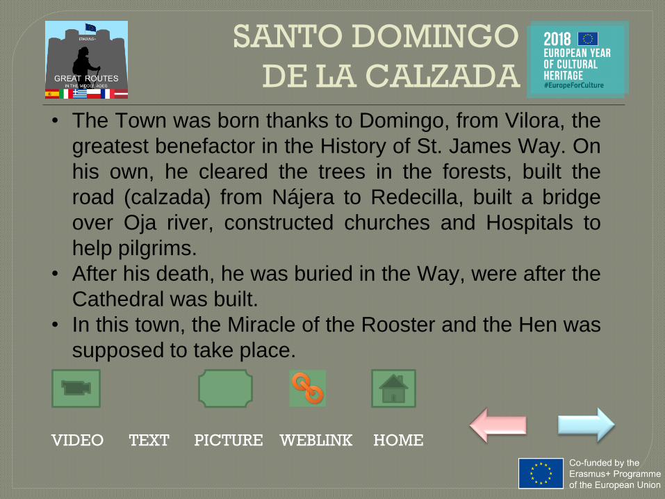
SANTO DOMINGO
DE LA CALZADA
VIDEO TEXT PICTURE WEBLINK HOME
• The Town was born thanks to Domingo, from Vilora, the
greatest benefactor in the History of St. James Way. On
his own, he cleared the trees in the forests, built the
road (calzada) from Nájera to Redecilla, built a bridge
over Oja river, constructed churches and Hospitals to
help pilgrims.
• After his death, he was buried in the Way, were after the
Cathedral was built.
• In this town, the Miracle of the Rooster and the Hen was
supposed to take place.

SANTO DOMINGO
DE LA CALZADA
VIDEO TEXT PICTURE WEBLINK HOME

LOGROÑO
VIDEO TEXT PICTURE WEBLINK HOME
• A City grown up thanks to the Way of Saint James.
• We can visit the main street: Rua Vieja, still present.
• It was placed in the limit among the Kingdoms of Castille,
Aragon and Navarra.
• This city is also linked with El Cid, the Medieval warrior
main character of one of the Medieval Spanish poems:
The song of Mio Cid. El Cid attacked Logroño as part of
the rivalry he had against Count García Ordóñez.
• The Gothic church includes works by Michelangelo
Buonarroti, and replaces the original Romanesque church

LOGROÑO
VIDEO TEXT PICTURE WEBLINK HOME

PUENTE LA REINA
VIDEO TEXT PICTURE WEBLINK HOME
• A town born because and for the Way of St. James.
• The bridge, built during the 11th Century allowed the
pilgrims to cross the Arga river.
• The church of the Cross, of Templar foundation, can still
be visited.
• This is the town where the legend of the Txory (Bird) and
the Virgin is supposed to take place.

PUENTE LA REINA
VIDEO TEXT PICTURE WEBLINK HOME

RONCESVALLES
VIDEO TEXT PICTURE WEBLINK HOME
• First step of the Spanish part of the Way of Saint James
• It’s place in one of the natural places to cross the
Pyrenees, placed at more than 1500 m over the level of
the sea.
• Through this way, Charlemagne crossed this mounts
direction Zaragoza, and came back after been defeated.
• The ambush suffered while they came back home here, is
narrate in The Song of Roland, the French Medieval
Poem.

RONCESVALLES
VIDEO TEXT PICTURE WEBLINK HOME

WAY OF VERA CRUZ
VIDEO TEXT PICTURE WEBLINK HOME

WAY OF VERA CRUZ
VIDEO TEXT PICTURE WEBLINK HOME
• It goes from the Pyrenees to Caravaca de la
Cruz, where a fragment of “Lignum Crucis” is
venerated.
• It was known during the Middle Ages and a lot
of pilgrims also travelled throught it.
• Currently, nearly 900 km have been
recovered, and pilgrims travel again through
it.

WAY OF VERA CRUZ
VIDEO TEXT PICTURE WEBLINK HOME

CALATAYUD
VIDEO TEXT PICTURE WEBLINK HOME
• The fortified part, giving name to the city was built during
the Middle Ages, and the Muslim invasion of the
Peninsula. It was called Qal’at Ayyub (Ayyub’s castle).
• After being reconquered by Alfonso I, the Fighter, in 1120,
the city grew up and it’s the second city in population and
importance of Aragon.
• In 1461, Ferdinand II, later the Catholic King, is
proclaimed the heir of the King in this city.

CALATAYUD
VIDEO TEXT PICTURE WEBLINK HOME

CARAVACA DE LA CRUZ
VIDEO TEXT PICTURE WEBLINK HOME
• Placed in the cross between the Kingdom of Grenade and
the Kingdom of Murcia, it was a fortressed town in the
edge of the Christian kingdom. During the Middle Ages,
Templars settled there, and at that time, they are
supposed to have bring a piece of the Holy Cross with
them.
• The Church of the Real Cross, from the 18th Century, is
the place where this piece can be venerated, and it’s
placed into the Muslim fortress from the 10th – 11th
Century.

CARAVACA DE LA CRUZ
VIDEO TEXT PICTURE WEBLINK HOME

MEDITERRANEAN
EXPANSION
VIDEO TEXT PICTURE WEBLINK HOME

MEDITERRANEAN
EXPANSION
VIDEO TEXT PICTURE WEBLINK HOME
• During the 13th Century, kings from Aragon
started their expansión throughout the
Mediterranean.
• They had political reasons, but also artisans
could find their raw material.
• Manufactured products could also be
exported.

SPICES ROUTE
VIDEO TEXT PICTURE WEBLINK HOME

SPICES ROUTE
VIDEO TEXT PICTURE WEBLINK HOME
• Europeans in 11th Century were used to
some products due to their contact with
Orient.
• The Mediterranean Sea was the nexus
between Orient and Occident and was the
route throught which the trade of Spices took
part.

MEDITERRANEAN
ROUTE
VIDEO TEXT PICTURE WEBLINK HOME

VIDEO TEXT PICTURE WEBLINK HOME
• From southern European ports to Eastern
Turkey. To exchange manufactured products
and metals by silk, coffe and luxury articles.
• It arrived to the ports of Bizantyum, Egipt and
Syria, but also to ports in South France,
Sardinia and Sicily
MEDITERRANEAN
ROUTE

OTHER ROUTES
VIDEO TEXT PICTURE WEBLINK HOME

EXPORTS
VIDEO TEXT PICTURE WEBLINK HOME

WOOL
VIDEO TEXT PICTURE WEBLINK HOME
• Wool was exported throught the
Mediterranean and the South of France. Wool
from Aragon had hight quality, and was sold
to Italy, or transformed into fabrics in
Catalonia.

WOOL
VIDEO TEXT PICTURE WEBLINK HOME

WHEAT
VIDEO TEXT PICTURE WEBLINK HOME
• Wheat from Aragon was
exported throuh Ebro river to
Tortosa.
• This route was frequently
attacked by pirates.

WHEAT
VIDEO TEXT PICTURE WEBLINK HOME

OIL
VIDEO TEXT PICTURE WEBLINK HOME
• Oil was sold to the south of
France and Navarra. Catalonia
manufactured wine, oil and dry
fruits.

OIL
VIDEO TEXT PICTURE WEBLINK HOME

SAFFRON
VIDEO TEXT PICTURE WEBLINK HOME
• Saffron from Alcañiz, Híjar,
Alcorisa, Maella and Nonaspe
was widely exported.

SAFFRON
VIDEO TEXT PICTURE WEBLINK HOME

POTTERY
VIDEO TEXT PICTURE WEBLINK HOME
• Pottery from Muel, Calatayud
and Teruel was famous.

POTTERY
VIDEO TEXT PICTURE WEBLINK HOME

IMPORTS
VIDEO TEXT PICTURE WEBLINK HOME

IMPORTS
VIDEO TEXT PICTURE WEBLINK HOME
• Aragon imported manufactured products,
some of them with raw materials from Aragon,
or luxury products from Orient.
• Products arrived from the Mediterranean
throught Fraga, Ebro’s route and from
Barracas, were mainly spices, colourants,
quality fabrics and medicines.

SPICES
VIDEO TEXT PICTURE WEBLINK HOME

COLOURANTS
VIDEO TEXT PICTURE WEBLINK HOME

MEDICINES
VIDEO TEXT PICTURE WEBLINK HOME

LEGEND FOR MAPS
TRADE ROUTES
RELIGIOUS ROUTES
SEA ROUTES
RIVER ROUTES
AGRICULTURAL ROUTES
MAIN CITY
INTERMEDIATE CITY