great barrier island / aotea dl · beautiful beaches backed by tidal creeks and wetlands....
TRANSCRIPT

AUCKLAND
Hauraki Gulf Marine Park
Great Barrier Island/Aotea
Further informationAotea / Great Barrier Island Base Private Bag 96002 Great Barrier Island 0961
PHONE: 09 429 0044 EMAIL: [email protected]
Published by: Department of Conservation DOC Aotea / Great Barrier Island Base Private Bag 96002 Great Barrier Island
October 2019
Editing and design: DOC Creative Services, Conservation House, Wellington
Front cover: Aotea Track. Photo: Andris Apse Back cover: Kākā landing in a pōhutukawa tree. Photo: Leon Berard
This publication is produced using paper sourced from well-managed, renewable and legally logged forests.
R15
3740

Aotea and Ngāti RehuaThe island renown
Aotea whakahirahiraAotea taonga mahaAotea utanganui
Aotea the island of renown Aotea the island of many treasures Aotea of the bountiful cargo
Aotea is the ancestral land of the Ngāti Rehua hapū of Ngāti Wai. It is the southeastern outpost of the tribal rohe of the Ngāti Wai iwi.
Although each island, islet and rock has its own individual character and identity, Aotea is viewed as a single physical and spiritual entity over which a ‘spiritual grid’ lies. At its centre stands Hirakimata (Mt Hobson), the maunga tapu of Ngāti Rehua. To the north of the island is Nga Tara Tara o Toi (Needles Point). To the west is Rangiahua Island (Flat Island) and Mahuki Island (Anvil Island). To the east is Kaitoke Kohatu, with Motu Tohora to the south. The southernmost landmarks of Ngāti Wai are the Manaia and Ruahine mountains that stand above Rangitawhiri/Tryphena.
The memories, traditions and identity of a people with one thousand years of ancestral associations are captured in this pepeha/proverb, which dates back to the early arrival of the Aotea canoe.
Photo: Eugene Polkan
ContentsAotea and Ngāti Rehua . . . . . . . . . . . . . . . . . 1Ridge to reef . . . . . . . . . . . . . . . . . . . . . . . . . . 2The west coast . . . . . . . . . . . . . . . . . . . . . . . . . . . 3The east coast . . . . . . . . . . . . . . . . . . . . . . . . . . . . 3Marine life . . . . . . . . . . . . . . . . . . . . . . . . . . . . . . . . 4Seabirds . . . . . . . . . . . . . . . . . . . . . . . . . . . . . . . . . . 4Rich history . . . . . . . . . . . . . . . . . . . . . . . . . . 5Mining . . . . . . . . . . . . . . . . . . . . . . . . . . . . . . . . . . . 5Whaling . . . . . . . . . . . . . . . . . . . . . . . . . . . . . . . . . . 6Shipwrecks . . . . . . . . . . . . . . . . . . . . . . . . . . . . . . . 6Historic buildings. . . . . . . . . . . . . . . . . . . . . . . . . 6Kauri . . . . . . . . . . . . . . . . . . . . . . . . . . . . . . . . . . . . . 7Living treasures . . . . . . . . . . . . . . . . . . . . . . .8Native and endemic plant life . . . . . . . . . . . . . 8Reptiles and amphibians . . . . . . . . . . . . . . . . . . 9Marine life . . . . . . . . . . . . . . . . . . . . . . . . . . . . . . . 9Birds . . . . . . . . . . . . . . . . . . . . . . . . . . . . . . . . . . . . 10Wild spaces. . . . . . . . . . . . . . . . . . . . . . . . . . 12
Detailed map of tracks on Great Barrier Island/Aotea . . . . . . . . . . . . 14Aotea Track . . . . . . . . . . . . . . . . . . . . . . . . . 16Hirakimata (Mt Hobson) summit tracks . . . . . . . . . . . . . . . . . . . . . . . 18Whangaparapara area tracks . . . . . . . . . .22Port Fitzroy area tracks . . . . . . . . . . . . . . .24Okiwi/Harataonga area tracks . . . . . . . . .26Help look after the Hauraki Gulf . . . . . . .28

Ridge to reefAotea lies on the outer edge of the Hauraki Gulf Marine Park – our national park of the sea. The Marine Park extends over an area of 1.2 million hectares of coast, marine environment and islands. It is protected because its natural and cultural heritage is rich, diverse and unique.
Aotea and the Hauraki Gulf were formed at the end of the last ice age when volcanic activity caused sea levels to rise. The higher land of Aotea separated from what is now the Coromandel Peninsula and became an island. Sea cliffs dominate the northwest and southeast coasts of the island. Rakitu Island (Arid Island) and other small islands and groups of rocks are dotted along its coast.
Captain James Cook named the island Great Barrier in 1769 for the shelter and protection it provides to the Hauraki Gulf. The island is only 90 km northeast of downtown Auckland and is easily accessible by plane or boat.
The west coast Forest-covered ranges meet the coast in a maze of bays, islands and indented fiords formed from flooded river valleys, such as the spectacular drowned valley system of Port Fitzroy. Boating, fishing and sea kayaking are popular activities here, and you can explore fascinating heritage sites, such as the old whaling station at Whangaparapara.
The east coast The eastern coastline is popular with surfers and swimmers, thanks to its sweeping white sands and beautiful beaches backed by tidal creeks and wetlands. Whangapoua estuary is one of the least-modified wetlands in New Zealand, and is valuable for coastal and wetland birds.
Eagle ray, Aiguilles Island. Photo: Kim
Westerskov
Ph
oto
: Eu
gen
e P
olk
an
65

Rich historyAotea is home to a community of around 900 residents, and has been continuously inhabited for much of the past 1,000 years. Māori oral history speaks of early occupation, and of Ngāti Wai and its chief Rehua settling on Aotea and claiming mana whenua over the land in the late 1700s. Being ancestral land, all of the island is sacred land to Māori. Its forests, bays and rivers tell stories of journeys, battles, living off the land and settlement.
You can experience the island’s culture and heritage by visiting some of the fascinating historic sites. Archaeological sites in accessible coastal areas have been dated to the earliest period of Polynesian settlement.
From the 1840s, the island’s natural resources attracted European settlement. A number of boom-and-bust industries exploited the island’s forests, minerals (copper, silver, gold) and migrating whales.
MiningCopper was discovered in the remote northern part of the island in 1841, and New Zealand’s earliest mine was established at Miners Head in 1842. Gold and silver were discovered in the 1890s.
The massive stone walls of the Oreville stamping (ore crushing) battery – above and below Whangaparapara Road – are an impressive reminder of the mining period.
KTC Tramway. Photo: Jim
Petrie, NZ
Herald
Marine lifeThe waters of the Marine Park are incredibly rich in wildlife, with 22 species of marine mammals. Look out for dolphins, whales and seals, which are all regular visitors to the island’s coast.
SeabirdsSeabirds are a special feature of the Marine Park. They feed in the rich waters and find sanctuary on the park’s many pest-free islands. Aotea provides important nesting and roosting sites, and provides for rare species like the takoketai/black petrel.
Coastal camping• Akapoua Bay Campsite is near the sheltered waters
of Port Fitzroy.• Awana Beach Campsite is near one of the island’s most
popular places to surf.• Harataonga Campsite offers snorkelling, swimming
and the coastal walkway.• Medlands Beach Campsite is a great picnic spot near
a beautiful surf beach.• The Green Campsite at Whangaparapara Harbour is
a secluded spot accessed by boat or short walk.• Whangapoua Campsite is on the edge of the estuary.
A popular surf break is a 10-min walk at low tide.
87

Kau
ri b
ark.
Ph
oto
: Sab
ine
Ber
ner
t
KauriThe kauri forests of Aotea were logged with increasing intensity between the 1880s and early 1930s. Many walking tracks within the Aotea Conservation Park follow old kauri logging and milling tramway routes. One of the island’s best-known historic landmarks was the Lower Kauri Dam on the Kaiaraara Track. In June 2014, a huge storm carried away the historic lower Kauri Dam, leaving only the base.
The Kauri Timber Company sawmill (in operation 1905–16) at Whangaparapara, once processed logs rafted by sea from the Coromandel and Northland. Among the ruins a steam tractor and cast iron chimney stack can still be seen.
A few areas of original kauri forest survived, and much of the forest is now regenerating. However, kauri are under threat from kauri dieback disease. Help protect kauri by always sticking to defined tracks, and keeping off tree roots. Footwear, tyres and any equipment that comes into contact with soil before and after leaving areas of kauri forest need to be cleaned.
See www.kauridieback.co.nz or call 0800 NZ KAURI for more information.
WhalingThe remains of New Zealand’s last whaling station can be seen at Whangaparapara. Whaling began in and around New Zealand waters in the 1790s, and peaked in 1839 when 150 American and 50 other whaling ships were recorded around its coasts.
ShipwrecksSince 1854, around 50 shipwrecks have occurred on the coast of Aotea. In 1894, the SS Wairarapa smashed into rocks near Miners Head and 121 passengers and crew died – New Zealand’s third-worst shipping disaster. Two gravesites remain: one on the west coast, the other on the east. Both sites are easily accessible (see map on page 14 and the fold-out map)
Historic buildingsBuilt in the 1860s, Ollies Cottage still stands at Puriri Bay. Homesteads at Harataonga, Tryphena and Port Fitzroy are reminders of colonial times. Tryphena School was built in 1884 and is now used as a community service building.
Kau
ri D
am. P
ho
to: A
nd
ris
Ap
se
Harataonga homestead. Photo: DO
C
109

Living treasuresIn the absence of many of the introduced pests and predators now present on mainland New Zealand, Aotea has become a lifeboat for many native animals and plants, including freshwater fish, bats, lizards, frogs and birds.
Native and endemic plant life After a tumultuous history of land clearance and kauri logging, much of Aotea is now covered in native vegetation. With the absence of many browsing animals, many plants and habitats on the island have been able to flourish. Kānuka and mānuka dominate the landscape, although mature pōhutukawa, tairare, pūriri and kauri are beginning to re-emerge.
Several rare plant species susceptible to browsing mammals have survived on the island, such as Kirk’s daisy, Pimelea tomentosa and sand tussock. Three plant species are found only on the island: the Great Barrier tree daisy, prostrate kānuka, and a subspecies of hebe.
Reptiles and amphibiansAotea is home to 13 different species of skinks and geckos, and New Zealand’s only island-based population of Hochstetter’s frog.
The chevron skink is one of New Zealand’s most endangered lizards. Found only here and on Te Hauturu-o-Toi/Little Barrier Island, it can grow to more than 30 cm long and is perfectly camouflaged to blend in with the leaf litter along the forested streams. Its Māori name, niho taniwha, refers to the tooth-like chevron markings along its back and means ‘teeth of the taniwha’.
Marine life Blue maomao, snapper, piper, sea turtles, sunfish, common and bottlenose dolphins and orca. Also Bryde’s, southern right and humpback whales.
KānukaPh
oto: Keri Neilson
Bo
ttle
nose
do
lphi
ns.
Ph
oto
: Jo
hn
McG
ow
an
Photo: Dick Veitch
If you discover a stranded whale or dolphin (dead or alive), report it to 0800 DOCHOT (0800 362 468) immediately.
Hebe
1211

Birds Many of the birds on Aotea are now rare on the mainland. They can be secretive and require patience to spot. Keep an eye out for the ones below.
Pāteke/brown teal Brown teals are among the rarest ducks in the world and are considered ‘At Risk – Recovering’ due to ongoing predator control. Aotea is home to almost two-thirds of the world’s remaining population. They are mainly active at night, but can commonly be seen foraging along estuaries and the water’s edge during the day. They are extremely vulnerable to predation and are often hit by cars on the road at night. Please take care when driving.
Shorebirds and wadersThese include native and migrant species such as the Caspian tern, wrybill, pied stilt, banded dotterel and bar-tailed godwit.
Most conspicuous in summer are the New Zealand dotterel and variable oystercatcher. These birds breed above the high-tide line, mostly on the white sandy beaches along the east coast of the island. Their nests are well camouflaged and easily trampled.
SeabirdsThese include takoketai/black petrels (see page 19), Australasian gannets, common diving petrels, fluttering shearwaters, Cook’s petrels, grey-faced petrels, little blue penguins and Buller’s shearwaters.
The New Zealand storm petrel is also sometimes spotted off the north of the island.
North Island kākāThese large, brown, noisy parrots are often seen flying high above the forest canopy and their raucous call is part of the island’s atmosphere. They are considered ‘At Risk – Recovering’ and are locally extinct from most parts of their former range on the mainland.
Banded railOften mistaken for baby weka, banded rails are a common sight. They often run out on the road, so take care when driving!
Takoketai/black petrel. Photo: Terry C
Greene
Pāteke. Photo: Sabine Bernert
Ban
ded
do
tter
el.
Ph
oto
: Ja
mes
T R
eard
on
Ban
ded
rai
l. P
ho
to: A
nd
ris
Ap
se
North Island kākā. Photo: Sab
ine B
ernert
North Island robin
1413

Wild spacesFar from traffic and city lights, Aotea is the ultimate place to get away from it all. The landscape is rugged and remote, and is one of the Auckland region’s last great wilderness areas.
In the centre of the island, spectacular bluffs and ridges rise to the highest peak – Hirakimata (Mt Hobson) at 621 m. The clear, warm waters surrounding the island are perfect for swimming, diving and snorkelling, and some of the eastern beaches can whip up some of the best surf in the country.
Take a gentle walk along one of the many lowland bush trails or hike through beautiful regenerating coastal forest. Form the only set of footprints on a magnificent white, sandy beach and relax in the warm, secluded hot pools reached from the Whangaparapara road. The wild landscapes of Aotea provide the perfect backdrop for an adventurous, active holiday, or a relaxing escape from city life.
Outstanding views are in oversupply. One visitor once remarked,
“There are just too many beautiful places!”
Ao
tea
coas
tlin
e. P
ho
to: E
ug
ene
Po
lkan
Vie
w fr
om H
irak
imat
a (M
t Hob
son)
. P
ho
to: A
ndri
s A
pse
1615

Hot Springs
Remains ofKauri dam
TE AHUMATATRACK
FOREST ROAD
Akapoua
ToClaris
WindyCanyonLookout
Car park
Bush's BeachPicnic Area
SOU
TH F
OR
KTR
ACK
SOUTH FORK
TRACK
FOREST RD
CampsiteCoopers Castle
The Pinnacle
PALMERS TRACK
KAIARAARATRACK
AOTEA CONSERVATION PARK
TRAM
LINE
TRA
CK S
OUT
H
PEA
CH
TREE
TRACK
TRAMLINE
NORT
H
TRAC
K
HOT SPRING
STK
TE AHUMATA TRACKOLD MILL T RA
CK
WITHEY'S
TRACK
Whangaparapara
Te Ahumata
KAITOKE
COOPERS CASTLE TRACK
Remains ofKauri millRemains of
whaling station
Disusedmine
Derelictstamping battery
Mount Hobson
FOREST ROAD
KIWIR
IKI TRAC
K
FOREST RO
AD
TRAMLINE TRACK NORTH
Mt HealeHut
KaiaraaraHut
The GreenCampsite
321
240
250
280
372
425
270
510
465 290495
242
627
309
398
240
179
Whangaparapara
Okupu
PortFitzroy
Okiwi
MangatiBay
Long BayFrench
Bay RapidBay
WhangaparaparaHarbour
CopperMine Bay
KiwirikiBay
BlindBay
AllomBay
OkupuBay
KaiararaBay
Rarohara Bay(Ungunu Bay)
0 0.5 1 Km
WairahiRiver
CoffinsCreek
Stream
Kaiarara
Awana
SunbeamCreek
Conservation Land
Council tracks
Ot er tracks
Kauri diebackhygiene station
Unsealed road
Road
DOC Public
Legend
DOC Campsite"DOC Hut"Mountain bikes
(caution)Parking areaPicnic siteLookout
Aotea Track
Other tracks
Council tracks
Road
Unsealed road
hygiene stationKauri dieback
DOC PublicConservation Land") 0 0.5 1 Km
´
Detailed map of tracks on Great Barrier Island/Aotea
Walking tracks key for following pages
Walking Track
Suitable for people with low to moderate fitness and abilities. Walking shoes or light tramping boots required.
Tramping Track
Suitable for people with good fitness. Moderate to high level backcountry (remote areas). Skills and experience, including navigation and survival skills, required.
Route
Challenging overnight tramping/hiking. Track unformed, may be rough or steep. Suitable for people with above-average fitness, and high-level backcountry skills and experience.
1817
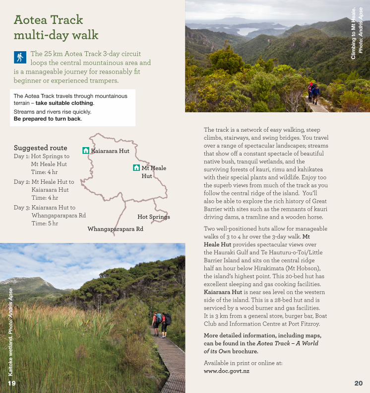
Aotea Trackmulti-day walk
The 25 km Aotea Track 3-day circuit loops the central mountainous area and
is a manageable journey for reasonably fit beginner or experienced trampers.
The track is a network of easy walking, steep climbs, stairways, and swing bridges. You travel over a range of spectacular landscapes; streams that show off a constant spectacle of beautiful native bush, tranquil wetlands, and the surviving forests of kauri, rimu and kahikatea with their special plants and wildlife. Enjoy too the superb views from much of the track as you follow the central ridge of the island. You’ll also be able to explore the rich history of Great Barrier with sites such as the remnants of kauri driving dams, a tramline and a wooden horse.
Two well-positioned huts allow for manageable walks of 3 to 4 hr over the 3-day walk. Mt Heale Hut provides spectacular views over the Hauraki Gulf and Te Hauturu-o-Toi/Little Barrier Island and sits on the central ridge half an hour below Hirakimata (Mt Hobson), the island’s highest point. This 20-bed hut has excellent sleeping and gas cooking facilities. Kaiaraara Hut is near sea level on the western side of the island. This is a 28-bed hut and is serviced by a wood burner and gas facilities. It is 3 km from a general store, burger bar, Boat Club and Information Centre at Port Fitzroy.
More detailed information, including maps, can be found in the Aotea Track – A World of its Own brochure.
Available in print or online at: www.doc.govt.nz
Suggested routeDay 1: Hot Springs to
Mt Heale Hut Time: 4 hr
Day 2: Mt Heale Hut to Kaiaraara Hut Time: 4 hr
Day 3: Kaiaraara Hut to Whangaparapara Rd Time: 5 hr
The Aotea Track travels through mountainous terrain – take suitable clothing.
Streams and rivers rise quickly. Be prepared to turn back.
Kaiaraara Hut
Mt Heale Hut
Hot Springs
Whangaparapara Rd
Kai
toke
wet
land
. Ph
oto
: And
ris
Aps
e
Clim
bing
to M
t Hea
le.
Ph
oto
: And
ris
Aps
e
2019

Hirakimata (Mt Hobson) summit tracksTo stand at the top of Hirakimata (Mt Hobson), with a 360-degree panorama, is what many trampers set as their primary goal once they’ve landed on the island.
There are three routes to get to the summit, described in detail on the following three pages. Nearing the summit, either from the northeast, the west or the south, the tracks lead into mature forest where logging was too difficult and fires on the lower slopes did not reach. Remnants of an ancient and precious conifer forest – rimu, Kirk’s pine, pink pine and kauri – can be seen here.
Keep an eye out for takoketai/black petrelsOnce widespread on the North Island, breeding colonies of these large, burrow-nesting seabirds are now confined to Aotea and Te Hauturu-o-Toi/ Little Barrier Island. The main colony breeds here on the slopes of Hirakimata (Mt Hobson) between October and May each year. Mature birds spend months at sea flying as far as South America and only return to the island to breed. Watch out for them on the road at night.
Mt Hobson summit via Hot Springs and Peach Tree Tracks
5 hr one way, 7.9 km
Starting from Whangaparapara Road, the journey to the top begins flat and easy – very friendly for pushchairs. The path follows an ancient shoreline traversing the Kaitoke wetlands and regenerating kānuka forest. You may hear the call of a fernbird or spotless crake. Orchids and sun dews flower close to the track. Forty-five minutes later at the hot pools, dammed at a fork in Kaitoke Creek and surrounded by the delicate umbrella fern, the track changes. After a brief, steep climb and descent to join Tramline Track, with reminders of loggers’ toil and journeys of 80 years ago, Peach Tree Track soon appears on the left and the climb begins through regenerating forest.
Forty-five minutes from the summit, the track passes Mt Heale Hut. Wake up to wide views from the north west through to the south.
Enjoy the hot pools but take care – they might be too hot in places. Do not put your head under the water.
Mt
Ho
bso
n su
mm
it. P
ho
to: A
ndri
s A
pse
Please keep to the tracks to avoid damaging rare native plants and disturbing takoketai/black petrels.
Photo: Terry C Greene
2221

The
Tw
in s
lip s
win
g b
rid
ge.
P
ho
to: A
ndri
s A
pse
Mt Hobson summit via Kaiaraara Track3 hr – 3.5 hr one way, 5.6 km
Kaiaraara Track begins at Forest Road near the Kaiaraara Hut – a spaghetti junction of the island’s track system. Like many of the island’s tracks, Kaiaraara offers a striking experience for walkers – a wide array of flora from tiny plants and ground cover to large trees in established forest, historic sites and, towards the summit, panoramas of the island, its bays and beaches, and neighbouring islands.
From Forest Road, the track rises steadily to Cooper’s Castle Track junction, crossing the stream in several places using a series of swing and wooden bridges. A short distance from this junction is a side track to the remnants of Lower Kauri Dam. The track below this dam winds through semi-mature forest with good examples of tōwai and large kohekohe.
From the dam, the track climbs steeply via wooden steps that protect takoketai/black petrel nesting grounds and sensitive ecosystems. The Lower Kauri Dam (1 hr 30 min from Kaiaraara Hut) was built in the 1920s, along with six smaller dams higher up. Logs estimated to contain seven million feet of timber were slid into the dams. Once loaded, the dams were tripped one after the other so a full blast hit the lower dam, propelling the logs into Kaiaraara Bay.
Mt Hobson summit via Windy Canyon
and Palmer’s Track3 hr one way, 3.3 km
This is the shortest and easiest of the three paths to the summit. The track begins at the top of Whangapoua Hill on Aotea Road and climbs numerous steps through the sheer rock faces of Windy Canyon (10 minutes from the road). There are splendid views of Okiwi Basin and Whangapoua Beach and estuary to the north, and Kaitoke and Medlands beaches to the east.
The track follows the ridge offering constantly changing vistas in every direction before climbing steeply to the summit, traversing steep inclines via an impressive system of steps and stairways. Healthy examples of the endemic plant prostrate kānuka can be seen among regenerating forest. On the ridge still stands the ‘wooden horse’, a sturdy H-frame used for winching logs from the eastern slopes up and over the saddle, before sending them plummeting down the other side on their way to the sea.
Hirakimata (Mt Hobson) is the site of several rare species. It is the favoured choice of the tomtit, black petrel and recently re-introduced North Island robin, and is frequented by kākāriki and kākā. The beautiful endemic Great Barrier tree daisy and tiny sun dews like it here as well.
“I saw what had happened to the Kaiaraara stream. The banks of the stream had been torn and mutilated. Its bed was four or five times its former width… The defacement of that valley was complete.”John Mowbray, Mt Hobson’s Scroll of Fame, The New Zealand Observer, 18 July 1931.
Win
dy
cany
on.
Ph
oto
: And
ris
Aps
e
2423

Wha
ngap
arap
ara
harb
our.
Ph
oto
: D W
alke
r
Whangaparapara area tracksWhangaparapara was the setting for several early industries. Within its harbour are the remains of a whaling station and a sawmill that processed logs from as far away as Northland and the Coromandel. A steam engine, chimney stack and stone walls remain. Like many of the island’s western bays, Whangaparapara was also an outlet for kauri logs.
Tramline Track 6 hr one way
The Tramline Track system, which extends about 8 km from Whangaparapara to Aotea Road, traverses most of the island at its widest point. The Whangaparapara end of the track progresses over several bridges before joining back to Forest Road.
Withey’s Track 1 hr 30 min – 2 hr 30 min one way
Named after Bill Withey, who was a steam hauler operator for the Kauri Timber Company, Withey’s Track comes off South Tramline track and links onto Forest Road.
Old Mill Track 1 hr 30 min return
The Old Mill track is a 2 hr return trip, and begins close to Whangaparapara Road and travels through rejuvenating bush. Old Mill Track follows the edge of mangroves to The Green campsite (15 minutes), before crossing two steep spurs and descending to the site of the Kauri Timber Company sawmill and a historic steam traction engine. At low tide, the track can be walked around the shoreline, beginning at The Green campsite.
Te Ahumata Track1 hr one way
This track follows an old mining road between Whangaparapara and Blind Bay roads. From either end a 30 minute gradual climb leads to a junction, where a branch track (a further 30 minutes) leads to the summit covered with wind-shorn, bonsai-like native plants and numerous orchid species. There are panoramic views in every direction. Please stay on the designated track.
Ph
oto
: Eu
gen
e P
olk
an
2625

War
ren’
s Tr
ack.
Ph
oto
: Ter
ryy
Sm
ith
Port Fitzroy area tracksDuring the summer months, thousands come to Port Fitzroy, many by boat, to admire one of New Zealand’s most beautiful harbour entrances. At its mouth sits Motu Kaikoura (Selwyn Island), complementing the main island with its many bays and forested slopes. Port Fitzroy is the starting point for much of the island’s track system, at the same time offering a variety of shorter walks and vantage points.
Old Lady Track 1 hr one way
Old Lady Track links the harbour to Port Fitzroy hill as it follows a stream through remnant gully forest of pūriri and kohekohe. A steep side-track leads to a lookout rock with impressive views over the harbour.
Warren’s and Bridle Tracks1 hr one way
One kilometre from Port Fitzroy, Warren’s Track is a gently graded climb to a waterfall, the stream offering deep pools good for swimming. It continues on through kauri plantation before joining Bridle Track, which leads to the Fitzroy store. An easy grade through indigenous and exotic forest, this track is an alternative to walking the road.
Bush’s Beach Track35 min one way
Beginning at Kaiaraara Hut, this track is part of the old riding track from Port Fitzroy to the Wairahi Valley. The boardwalk was built to protect kauri from kauri dieback disease.
Kiwiriki Track4 hr one way
This track continues on from Bush’s Beach Track. It follows the same original riding track to a junction with Line W Track (30 minutes), then descends and crosses Coffin’s Creek, travelling through lowland forest remnants of pūriri, nīkau, kohekohe and concentrations of kōwhai and pōhutukawa on the coast. The track climbs steadily and follows the dividing ridge before veering right and dropping steeply to the valley floor and sign-posted junction (1 hr 30 min), leading to a 15 minute walk to the head of Kiwiriki Bay. The main track crosses Kiwiriki Stream and climbs through the valley and central ridge to meet Forest Rd at Maungapiko (1 hr 30 min).
Line W Track1 hr one way
This track branches off Kiwiriki Track to join directly with Forest Road, enabling a much shorter round trip from, and back to, the Kaiaraara Hut without having to go to Maungapiko.
South Fork Track3 hr one way
Beginning 1 km south of Kaiaraara Hut, South Fork Track follows an old bridle track. It crosses the stream twice, then climbs steadily to a swing bridge on the way to the central ridge. It travels through regenerating forest with excellent examples of tutu. Note: first stream crossing from Kaiaraara end, walk 500 m upstream and follow the orange markers.
The river rises quickly after heavy rain.
Forest Road5 hr one way
Thirteen kilometres in length and once criss-crossed with forestry tracks, Forest Road is a popular trek for both trampers and mountain bikers, providing a wide array of beautiful bush and mountain views.
Be careful when crossing creek in flood. 2827

Okiwi/Harataonga area tracksThe Harataonga Coastal Walkway, which links with Okiwi Basin and Harataonga campsite, is a popular walk on this eastern coast. Okiwi claims a second campground on the shores of Whangapoua estuary and the beach of the same name is one of the most beautiful in New Zealand.
Harataonga Coastal Walkway4–5 hr one way
This easy walk does not have the steep grades of many of the island’s other tracks. It winds through regenerating forest and was once the road linking the island’s south and north. From Harataonga campsite, the track heads west across a stream before following a coastline of magnificent views. The track ends at Aotea Road at the south end of Okiwi Basin.
Harataonga Loop Track30 min one way
This track branches to the right, close to the Harataonga end of the Coastal Walkway. The track loops back to the campsite passing close to a pā site, sea and coastal views.
Cooper’s Castle Track 2.5–3 hr one way
This track begins at the top of Okiwi/Port Fitzroy Hill on Aotea Road, and ascends the southern ridge under a forest canopy with views both sides of the island. At a sign-posted junction to Cooper’s Castle Track (2 hr), a 5 minute detour leads to Cooper’s Castle lookout, where a large volcanic-rock bluff gives extensive views of Okiwi Basin and the Whangapoua estuary. The main track descends to Kaiaraara Track, and the remnants of the lower Kauri Dam.
Tramline Track6 hr one way
The Tramline Track receives minimal upkeep – for fit trampers only. From its northeastern beginning on Aotea Road, it follows the old tramline used by the Kauri Timber Company during the 1920s and 1930s. It is sometimes very steep and was a remarkable engineering feat of its time. It descends abruptly to Awana Stream and waterfall before climbing steeply to a plateau and then dropping to Kaitoke Stream. The track crosses several creeks, crossing Forest Road and linking with the Whangaparapara tramline extension.
Burrill Route 8–9 hr return
Formed in the early 1970s as mining access for copper, Burrill Route begins at Mabey’s Road. This route is named after the late Max Burrill, who farmed some of the northern parts of Aotea. It climbs steeply through the regenerating forest of Te Paparahi to the central ridge and follows through to Tataweka (526 m). The track is not regularly managed, is indistinct in some places and is for fit trampers only. No water is available on this route.
Te PaparahiTe Paparahi is of significant importance to Ngāti Rehua as it holds taonga and spiritual values of people, flora, fauna, land and water. It was also the last stronghold for kōkako on the island after the population plummeted to near extinction from predation and habitat loss. The last two kōkako were transferred to Te Hauturu-o-Toi/Little Barrier Island in 1994 with the hope that their offspring will be brought back to Aotea once predators such as cats and rats are controlled.
3029

Why aren’t there more birds?Animal and plant pests destroy our wildlife treasures. Although Aotea has fewer introduced predators than the mainland, it has a number of pests that affect habitat. The island is now home to large numbers of ship rats and feral cats, amongst other pests such as mice and pigs. Many species such as whiteheads, bellbirds and kōkako have been lost from the island, and others such as kākāriki and tomtits are just hanging on.
Hope for the futureLocals, community groups and DOC are working hard to reduce the effects of these predators. Good results are already being seen and the wildlife is starting to return to these protected areas. Weed
control programmes are also underway on key sites. Argentine ants and rainbow skinks are recent arrivals, and are the focus of an intensive programme by DOC and Auckland Council to manage their invasion and hopefully eradicate them.
How you can helpYou can help protect this special place. Aotea doesn’t have Norway rats, possums, stoats and other mustelids, or hedgehogs. Please check all your gear (boats, cars, kayaks, tents, cases and backpacks) for stowaways before you head to the island. Clean dirty gear, especially footwear, for soil and seeds – weeds are a serious problem. It is a good idea to pack food in sealed containers as open bags provide easy access for pests.
Help look after the Hauraki Gulf
Unsupervised dogs are also a risk to wildlife on the island, so please keep any dogs under control.
31

WildlifeHochstetter's frog. Photo: Sabine Bernert
Green gecko. Photo: Sabine Bernert
Kōtare/kingfisher Photo: Andrew
WalmsleyMiromiro/tomtit
Photo: Sabine Bernert
Pītoitoi/tomtit Photo: Vincent
ZintzenPihipihi/waxeye
Photo: Sam O’Leary
New Zealand fur seal Photo: Sabine Bernert
Kōriroro/ grey warbler
Photo: Sabine Bernert
Kākāriki Photo: Sabine Bernert
Mātātā/fernbird Photo: Craig McKenzie
Moho pererū/ banded rail
Photo: Andris Apse
Kererū/ Photo: Sabine Bernert
Tūturiwhatu/ New Zealand dotterel
Photo: Shellie Evans
Tūī Photo: Dean Wright
photonewzealand
Kororā/little blue penguin Photo: Shellie Evans
Matuku-moana Photo: Andrew
Walmsley
Tōrea pango/ variable oystercatcher
Photo: Shellie Evans

Hau
raki
Gul
f / Tīk
apa
Moa
na
Mot
u K
aiko
ura
(Sel
wyn
Isla
nd)
Rak
itu Is
land
(Arid
Isla
nd)
Aot
eaC
onse
rvat
ion
Park
Oki
wi
Mot
aire
he
Wha
ngap
oua
Beac
h
Oku
pu
Tryp
hena
Wha
ngap
arap
ara Bl
ind
Bay
Tryp
hena
Har
bour
Kath
erin
e B
ay
Wha
ngap
arap
ara
Harb
our
Port Fitzroy
Kiwirik
i Bay
Port
Abe
rcro
mbi
e
Ston
y B
each
Awan
a B
ay
Wha
ngap
oua
Est
uary
Awan
a C
amps
ite
Akap
oua
Cam
psite
Med
land
s C
amps
ite
Kaw
a
Wai
karo
Poi
nt
Wha
kata
utun
aPo
int
Te P
apar
ahi
Palm
ers
Bea
ch
Kaito
ke B
each
Med
land
s B
each
Cap
e B
arrie
r
Bro
ken
Isla
nds
(Pig
Isla
nds)
Mau
ngan
ui P
oint
Ahur
iri P
oint
Min
ers
Hea
d
Aigu
illes
Isla
nd
Nee
dles
Poi
nt
S.S
. Wai
rara
pa
S.S
. Wai
rara
pagr
aves
Har
atao
nga
Cam
psite
S.S.
W
iltsh
ire
Hira
kim
ata
(Mt H
obso
n)M
t Hea
le
Scho
oner
Bay
Mt H
eale
Hut
Kaia
raar
a H
ut
Old
Lad
yTr
ack
Gre
at B
arrie
r Isl
and
/ Aot
ea
The
Gre
en
Cam
psite
Tata
wek
a
S.S
. Wai
rara
pagr
aves
Kaw
a R
d
Mot
aire
he R
d
Kara
ka B
ay R
dAo
tea
Rd
Aotea Rd
Wha
ngap
arap
ara
Roa
d
Blind Bay Rd
Har
atao
nga
RdH
arat
aong
a Be
ach
Walter Blackw
ell Rd
Tryp
hena
Har
bour
Rd Shoal Bay Rd
Rosa
lie B
ay R
d
Mul
berr
yG
rove
621m
510m
Rua
hine
402m
526m
Wha
ngap
arap
ara
309mM
aung
apik
o28
0m
Win
dyC
anyo
n
Kai
toke
Hot
Spr
ings
Trac
k
Te A
hum
ata
Trac
k
Fore
stR
oad
War
rens
Trac
k
Shag
Poi
ntWha
ngap
oua
Cam
psite
Wha
ngap
oua
Cam
psite
DO
CH
ut"
DO
CC
amps
ite"
Mou
ntai
nbi
kes
(cau
tion)
Par
king
area
Look
out
His
toric
site
Lege
nd Pic
nic
site
Aot
eaTr
ack
hygi
ene
stat
ion
Kau
ridi
ebac
k
Roa
d
! (
Oth
ertra
cks
Cou
ncil
track
s
Uns
eale
dro
ad
DO
CP
ublic
Con
serv
atio
nLa
nd" )
´0
1Km