grassy point park - duluth · grassy point park is located at the end of a dead end road surrounded...
TRANSCRIPT

G r a S S y p o i n t pa r kSummary and overviewGrassy Point Park is a 26 acre linear park and boardwalk trail that is located in the Irving Park Neighborhood. It is isolated from residential areas as it is surrounded by the industrial, port area of the St. Louis River estuary. It also lacks connectivity to other trails, which makes it a destination trail to be accessed typically by car. The park and trail itself has river access, wildlife viewing opportunities, and a fishing dock. Recent sinking of the boardwalk has made the trail inaccessible.
2 - 37 02: PA R K M I N I - M A S T E R P L A N S
GRASSY POINT PARK LOCATION MAP
grassy Point Park

existing conditionsGrassy Point Park is located at the end of a dead end road surrounded by river industry. Most of the park is marsh land at the mouth of the Keene Creek to the St. Louis River. The site was part of the sawmilling industry in the nineteenth and twentieth centuries and contains many areas of piled up wood waste materials. Invasive vegetation exists throughout the park, but there are beautiful views of the river and wildlife. The existing boardwalk trail is about ¼ mile long and in current disrepair. An informal canoe/kayak launch exists southeast of the park entrance area. Much of the park area is inaccessible.
The Wheels On Trails organization completed a report in 2008, in which it evaluated several trails in Duluth, including Grassy Point Trail, for ADA accessibility. The report identified the entire boardwalk as accessible with areas of dangerous drop-offs, where the boardwalk does not have the appropriate edges for wheelchairs. The organization has advocated for improvements, such
strengths/oPPortunities: » Good birding location
» Good fishing at the dock
» The MNDNR is managing and planning for habitat and vegetation restoration, in coordination with the MPCA, the EPA Area of Concern, and the Great Lakes Restoration Initiative – the document “Conceptual Design Plan: Grassy Point Project” identifies restoration areas and initiatives
» Park entrance has benches and signage, but the opportunity exists to make it more of a gathering space with better informational signage
issues: » Park is difficult to find in the
industrial neighborhood
» Parking is limited
» Informal canoe/kayak launch is difficult to find and far from the parking area
» Boardwalk is under water in areas and inaccessible
» The isolated location of the park makes it attractive to vandalism and unintended users
» Invasive species exist throughout the park
» Better signage is required to describe the features and access points of the park and trails
GRASSY POINT PARK SITE INvENTORY28 St. Louis River Corridor NEIGHBORHOOD PARKS MINI MASTER PLANS FACILITY INVENTORY AND EVALUATION 29DRAFT 11.18.15 DRAFT 11.18.15
Keene Creek
0 10050 Feet
LegendPark boundaryDuluth Streams
N
GRASSY POINT GRASSY POINT
ABOUT THE PARK
EXISTING RECREATION FACILITIES
Play areas and Courts Fields PiCniCking trails other
Play equiPment Football Pavilion unPaved
basketball soccer shelter Paved
tennis soFtball tables boardwalk
horseshoe baseball Grills winter sPorts
bocce ball hockey rink
volleyball recreation center Pleasure skatinG
other buildinG sleddinG hill
tyPe: cross-country skiinG
USER CONVENIENCES / SUPPORT FACILITIES
benches Fire rinG restrooms Parking
bike rack GarbaGe can indoor restrooms on-street
bleacher liGhtinG oFF-street
drinkinG Fountain FlaG # hdcP sPaces
dumPster Plaques not Present
\
name grassy Point
address lesure street
neiGhborhood irving
classiFication sPeCial use
acreaGe 26.4
•Grassy Point Trail reaches the site. Connects to Keene Creek Trail. May connect to future Cross City Trail and/or Munger Trail Extension
•Birding spot•Accessible boardwalk (Wheels on Trails Group advocated for it)•Canoe/Kayak launch on west side
EXISTING CONDITIONS
Lesure Street
S 50
th A
ve W
Entrance Sign and Benches
Parking
Kayak/Canoe Launch ‐ Poor condition ‐Difficult access
Wood Waste Area
Boardwalk ‐ In disrepair/sinking ‐Currently closed
Overlook
2 - 38 S T. LO u I S R I v E R CO R R I D O R PA R K S M I N I - M A S T E R P L A N S : J u N E 2016

GRASSY POINT PARK SITE ANALYSIS
Existing wayfinding
Most segments of the existing boardwalk have edges to improve wheelchair safety along the trail
The floating boardwalk is becoming unstable, sinking with applied weight
The existing overlook provides great views of the river
needs assessment/input SummaryAt the stakeholder and community meetings, a desire was expressed for every park in the corridor to have basic amenities, including a bench, a picnic table, and a grill. Benches exist at the entrance to the park, but should be added along the boardwalk trail at appropriate viewing stops. A picnic area does not exist at Grassy Point Park today, but may be needed in coordination with canoe/kayak launch improvements. Wayfinding and directional signage to each park, within each park, and to nearby trails are also desired as a way to promote the parks. Wayfinding and directional signage is a need in and around Grassy Point, as it is difficult to find in the neighborhood. Information signage is also needed to describe the park amenities at the entrance to the park.
as an accessible boardwalk, at Grassy Point Park, which were installed. Since that time, the boardwalk has sunk in areas making in inaccessible to all trail users.
30 St. Louis River Corridor NEIGHBORHOOD PARKS MINI MASTER PLANS FACILITY INVENTORY AND EVALUATION 31DRAFT 11.18.15 DRAFT 11.18.15
Keene Creek
0 10050 Feet
LegendPark boundaryDuluth Streams
N
Lesure Street
S 50
th A
ve W
GRASSY POINT GRASSY POINTSITE OBSERVATIONS
OPPORTUNITIES
NOTES & COMMENTS
•Trail restoration, boardwalk restoration, and ecological restoration are all possibilities
•Reorient entrance seating•Possibly move canoe launch to Keene Creek Outlet, or repair existing
launch » Investigate options for canoe/kayak carry downs or carts
•Additional trail connections•Improve access to bird viewing platforms and add bird blinds•Enhance biocontrol (beetles & weevils) for purple lossestrife•Glossy buckthorn management•Consider winter access and recreational opportunities, snow shoeing,
ice skating trails, cross country skiing
•Environmental groups could have potential interest in match funding » EPA » St. Louis River Alliance » River Corridor Coalition » Wheels on Trails (accessibility issues with boardwalk) » DNR
» Coastal _____•Irving Community Club
» this is their connection to the river•Wheels on trails group - 2008 report •Frequent phone call complaints to Parks staff about condition of
trails•Canoe launch in poor condition•MNDNR is working on wood waste removal efforts•Tim Howard did a plan 20 years ago
•Boardwalk is sinking•Entryway benches face industry instead of natural areas•Poor quality vegetation- purple loosestrife, buckthorn•Interpretive sign•Recent ADA safety improvements
OPPORTUNITIES
Improve and Enhance Existing
Canoe launch
Repair Boardwalk
Add better signage and wayfinding from Irving Park neighborhood
Remove invasive vegetation and plant native vegetation
2 - 39 02: PA R K M I N I - M A S T E R P L A N S

Figure 2.19 grassy point park mini-master pLan concept
Lesure Street
S 50th Ave W
Burlington Northern Santa Fe Railroad
Grassy Point Park
[0’ 150’ 300’
Existing Park Boundary
From 2012 Conceptual Design Plan Developed for the MN Pollution Control Agency
*
New Signage/Wayfinding
Dangerous Trail Drop-off (from Duluth Accessible Trail Assessment 2008, Wheels on Trails)
k
New picnic table, signage and wayfinding
1
Improve trail access to canoe/kayak launch
2
Address ADA concerns3
Improve Canoe/kayak launch5
Remove buckthorn4
New overlook structure/bird blind
Repair Boardwalk 7
8
New water trail signage6
*Restore upland shrubs and tree areas
*Restore wet meadow
*Create designed pond
*Restore emergent vegetation
*Restore floating vegetation
*Restore submergent vegetation
*Restore shrub-carr areas
*New creek trail •Add canoe/kayak rest stop at end
*Restore shallow marsh around Keene Creek
*Restore open marsh area
*Excavate connecting channel and naturalize with plantings
Key Features:
• Restore habitat according to the 2012 Conceptual Design Plan: Grassy Point Project, St. Louis River Area of Concern (MN Pollution Control Agency, US Environmental Protection Agency, and Great Lakes Restoration, including: » Open water habitats and littoral zone
improvements. » Creek channel improvement and wetland
reconnection. » Open marsh restoration and upland habitat
improvement.• Repair boardwalk and overlook structure.• Add interpretive storytelling of paper mills and
sunken barge history.• Add bird blinds for wildlife viewing.• Improve wayfinding to site and to canoe/kayak
access.• Maintain winter trails.
Keene Creek
2 - 40 S T. LO u I S R I v E R CO R R I D O R PA R K S M I N I - M A S T E R P L A N S : J u N E 2016
Other desires from the community include adding bird blinds, fishing docks, and a more formalized canoe/kayak launch. The trails should be repaired to be usable and functional in all four seasons, with the potential addition of snowshoe trails, cross country ski trails, or ice skating trails.
concept plan & recommendationsThe concept plan for Grassy Point Park prioritizes and identifies the natural resource and habitat restoration improvements that are currently being planned by the MN DNR and MPCA. Other improvements include trail repair and accessibility, and canoe/kayak launch improvements. Close coordination with the DNR will ensure proper installation of improvements.
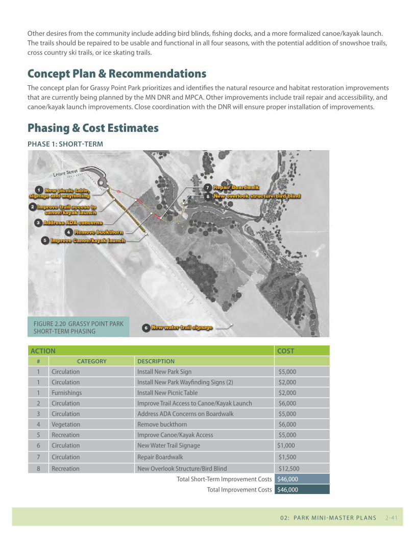
phasing & cost estimatesPhAse 1: short-term
Action cost# cAtegory descriPtion
1 circulation install new park sign $5,000
1 circulation install new park wayfinding signs (2) $2,000
1 Furnishings install new picnic table $2,000
2 circulation improve trail access to canoe/kayak Launch $6,000
3 circulation address ada concerns on boardwalk $5,000
4 vegetation remove buckthorn $6,000
5 recreation improve canoe/kayak access $5,000
6 circulation new water trail signage $1,000
7 circulation repair boardwalk $1,500
8 recreation new overlook structure/bird blind $12,500
total short-term improvement costs $46,000
total improvement costs $46,000
Figure 2.20 grassy point park short-term phasing
2 - 41 02: PA R K M I N I - M A S T E R P L A N S
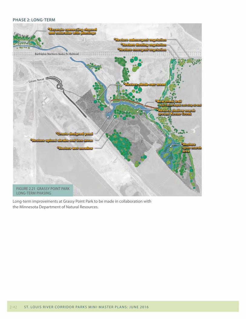
PhAse 2: long-term
Long-term improvements at Grassy Point Park to be made in collaboration with the Minnesota Department of Natural Resources.
Figure 2.21 grassy point park Long-term phasing
2 - 42 S T. LO u I S R I v E R CO R R I D O R PA R K S M I N I - M A S T E R P L A N S : J u N E 2016