grandview ilford - viarail.ca · viarail.ca populations are approximate. all other information was...
TRANSCRIPT

viarail.caPopulations are approximate. All other information was accurate at the time of printing.
TMTrademark owned by VIA Rail Canada Inc.6489 (12/2018) EN
RAILWAY SIGNS TO WATCH FOROne of the many railway traditions—the milepost—provides the key to locating a train’s current position. Mileposts may be on either side of a track, and are usually rectangular white signs with black numbers. Though Canada now uses the metric system, the original markers for railroads were in miles—and they still are today. Each line is subdivided at railway division points; these subdivisions are not a standard length, as they were based on the distance a steam locomotive could travel in a day.
MILEPOSTSMilepost numbers increase as you travel from east to west and reset to zero at the start of each subdivision. Subdivisions are 43 to 146 miles (69 to 235 km) long.
SIDING AND STATION NAME BOARDSNewer siding and station name boards are white with the name in black. Older station name boards are also white with the name in black, but the lettering is all uppercase and the signs are mounted on buildings.
YOURS TO KEEP
PIKWITONEI09 Mile: 137
Population: 98 (Northern community)Accessible only by rail, boat or winter road, Pikwitonei is a beautiful, tiny, isolated community ready to be explored by those curious enough to get on board.
ILFORD10 Mile: 137
Population: 43Home to the War Lake First Nation, Ilford was founded during the construction of the railway and today its residents survive off of hunting, trapping and government services. Accessible only by rail, air or winter road, Ilford is the epitome of remote, and is ready and waiting for those adventurous enough to explore it.
GILLAM (NELSON RIVER)11 Mile: 326.1
Population: 1,265Located in northern Manitoba, above the 56th parallel, Gillam was named after Captain Zachary Gillam and his son, whose mission led to the founding of the Hudson’s Bay Company on May 2, 1670. Today, Gillam attracts travellers searching to explore Canada’s vast wilderness. It’s many untouched lakes and streams offer endless fishing and its fly-in lodges are perfect for hunters, anglers and other lovers of the great outdoors.
CHURCHILL12 Mile: 509.8
Population: 899Churchill’s history begins well before the founding of Canada (evidence of human existence in the area dates back some 4,000 years). Today, it is accessible only by air or by railway, the latter having been built on the permafrost and muskeg in 1929. Erected on the banks of Hudson Bay, Churchill is the ideal place to spot birds, belugas and polar bears, and by night it is one of the world’s premier viewing areas for gazing up at the aurora borealis.
ROUTE GUIDE WINNIPEG o—o CHURCHILL
Grandview
Ilford
146
Grandview
Ilford
146
Grandview
Ilford
146
This guide to the Winnipeg–Churchill route will introduce you to the beauty of the boreal forest and subarctic regions of northern Manitoba—the ideal place to observe belugas in summer, polar bears in autumn, and the aurora borealis in winter. Its plant and animal life is among the most distinctive and breathtaking on the planet.
Bon voyage!
382
104
Winter rd.
16
16
16
16
16
16
16
16
16
16
16
16
1
1
1
1
17
71
17
17
17
17
17
17
7
7
69
11
11
11
11
11
1
1
1
1
1
1
1
1
1
11
11
1117
11
11
401
104
401
417
400
117
20
40
401
402
97C
97
5
3
19
117
117
OTTAWA
IS.
HOPEWELL
IS.
FARMERI.
SLEEPER
IS.
KINGGEORGE
IS.
BAKERS
DOZEN IS.
BELCHER
ISLANDS
NASTAPOKA ISLANDS
LONGI.
BEARI.
AKIMISKII.
CHARLTON I.
NORTHTWIN I.
SOUTHTWIN I.
MICHIPICOTEN I.
ISLE ROYALE
ST. IGNACE I.
ST. JOSEPH I.
COCKBURN I.
QUEENCHARLOTTE ISLANDS
PORCHER I.
PRINCESS ROYAL I.
CALVERT I.
HUNTER I.
ARISTAZABAL ISLAND
BANKSI.
PITT ISLAND
KING I.
MANITOULIN
I
SLAND
VANCOUVER ISLAND
Pt. Louis-XIV
Pea
Lake Athabasca Riverec
Tazin L.
Bistcho L.
Williston Lake
Chincha
ga
Hay
Peac
eHay
Peace
Nass
Skeena
R.
SkeenaR.
Finlay
Muskwa R.
Prophet R.
Dauphin Lake
LAKE
WINNIPEG
Cedar Lake
Molson Lake
GodsLake
Island Lake
Hayes R
iver
Burntwood
SplitLake
Nelson
OxfordLake
KneeLake
Hayes
Waskaiowaka LakeBaldock
Lake
GauerLake
Northern IndianLake Southern
Indian Lake
Granville L.
Rat Lake
River
Nueltin
Lake
Reindeer
Lake
Tadoule Lake
BigSandLake
Nejanilini Lake
CormorantLake
Wekusko Lake
HighrockLake
Stephens Lake
SipiweskLake
Lac LaRonge
Seal River
Gods River
Rive
r
River
Churc
hill
Churchill River
River
Lake Winnipegosis
Lake Manitoba
Red
Rive
r
South
Saskatchewan River
Saskatchewan
River
North
Atta
wapis
kat
River
Big Trout Lake
SevernL.
Sachigo Lake
WiniskLake
Attawapiskat
Lake
Mameigwess
Lake
Missisa L.
N. Caribou L.SandyLake
Trout Lake
Lac SeulLake
Nipigon
Lac desMille Lacs
Dog L.
L A K E S U P E R I O R
Rainy Lake Rainy River
Lak
e o f
the W
oods
Lake St. Joseph
Sturgeon
L.
Severn
R
iver
Albany
Rive
r
River
Winisk
Albany
Rive
r
Sever n R
iver
Fawn
R
iver
Ogoki River
Ke
nogamiRive
rLittle C
urrent
River
Lon
g Lak
e
QuesnelL.
Stuar t Lake
Babine Lake
Takla Lake
Ootsa Lake
FrancoisLake
Fraser River
LakeClaire
Lesser Slave L.
R.
River
R.
R.
River
RiverR.
River
CreeLake
Black Lake
Selwyn Lake
Wollaston Lake
Pasfield L.
ScottLake
Peter Pond L.Churchill Lake
Frobisher Lake
Turnor L.
Wasekamio L.Black Birch L.
Lac Ile-a-la-Crosse
MosquitoBay
PovungnitukBay
KogalukBay
JAMES
BAY
Riv.
Riv. Kogaluk
LacCouture
LacPayne
LacFaribault
Lac
TassialoucLac la
Potherie
LacMinto
Riv. Nastapoca
Lac Guillaume
Delisle Lac à
l ’Eau Claire
Riv.
Riv.au
x
Mélèze
s
DuGué
Riv.
aux
Feuille
s
Lacaux
Feuilles
Riv.
Kok
soak
Riv.
Caniapiscau
Riv.
à
la
Riv.
LacLe Moyne
Riv.
Riv.
du
Riv.
Sérign
y
Lac
Delorme
Lac
Caniapiscau
LacNaococane
LacPlétipi
Petite riv. de la Baleine LacBienville
Grande riv.
de la Baleine
Lac SakamiLa
R.
Grande
Riv.
Kanaa
upsco
w
Riv.
Sakami
Riv.
Opinaca
L. Temagami
Lake Nipissing
Ramsey
L. Onaping
L.
Lake Abitibi
Missinaibi L.
Kesagami
L.
Agawa Bay
Moos
e R
iver
Miss
inaibi
R
iver
Opa
satik
a
R.
Kapu
skas
ing
R
.
Mattagami River
Abitibi River
Groundhog River
H U D S O N
B A Y
Lac Kempt
Réservoir
Baskatong
Réservoir
Cabonga
Réservoir
Gouin
Lac
Nichicun
Lac
Mist
assin
i
Rivière Broadback
Rivière Harricana
Rivière Nottaway
Riv. de Rupert
Rivière Eastmain
Riv. Gatineau
Rivière des Outaouais
Rivière Coulonge
PrimroseLake Dore Lake
Montreal Lake
AmiskLake
Canoe L.
Quill
Lakes
Pemb
ina
Buffalo River Mikkwa River W
abasca River
Birch River
Atha
basc
a R
iver
Atha
basc
a
River
River
Brazeau River
Clearwater R.
Red
N. S ask
atch
ewan
R
iver
R.
Deer
Red Deer River
Little Bow R.
Bow River
Utikuma Lake
Battle
R
ive
r
Old Wives L.
Smoothstone Lake
Wathaman River
Cree
Rive
r
Kasba Lake
Maguse Lake
SnowbirdLakeWholdaia
Lake
Ennadai Lake
P A C I F I C
O C E A N
L A K E O N TA R I O
L A K E ER I E
L A K E H URON
LA
KE
M
I CH
I GA
N
LakeSakakawea
Missouri
FlatheadLake
Fort PeckLake
Missouri R.
Buffalo L.
Tazin R.
Hill Island L.
Thoa R.
Abitau
River
South Henik Lake
Edehon L.
Thlewiaza River
Tha-anne R.
Omineca R.
Bulkley R.
Kotcho L.
Murr
ay
R.
Pine R.
Halfway River
Sikanni
Chie
f River
Fontas R.
Beatton River
MoriceLake
Eutsuk Lake
Knight Inlet
Chilko L.
RedLake
Mississippi
River
R.
Red River
LakeWinnebago
Harrison Lake
QueenCharlotteSound
Dixon Entrance
Hecate Strait
Queen Charlotte Strait
ButeIn
let
Dougla
s Chan.
Dean Chan.
R.Nechako
McGregor River
Fraser River
Chilcotin River
Juan de Fuca Strait
Strait of Georgia
N. T
hompson R.
Okanagan Lake
Lower Arrow Lake
UpperArrow Lake
KootenayLake
Kinbasket Lake
Shuswap Lake
Loon
R.
Notikewin R.
Wapiti River
Smok
y
River
Little Smoky R
.
Atha
ba
sca
River
McLeod R.
Columbia
River
Adams Lake
Oldman R.
Beaver River
Christina
Rive
r
Clearwater River
Fond du Lac River
Mac
Farla
ne
Pinehouse L.
Fo
ster R
.
LastMountain Lake Lake
DiefenbakerQu’Appelle River
Souris River
Assiniboine
River
RedDeerL.
Red Deer R.
Carrot River
Saskatche
wan R
iver
Deschambault Lake
KississingLake
Geikie
R.
Phelps L.
Cochrane R.
Stony L.
NorthKnifeLake
Caribou R.
Owl Rive
r
Kaskatt
ama
R.
Black D
uck
R.
Cross Lake
Gunisao R.
Waterhen Lake
LakeSt. Martin
Poplar River
Berens River
Bloodvein River
Seine R.
English
River
Otoskwin
River Pipestone Rive
r
Sach
igo
R
iver
SuttonLake
Asheweig Rive
r
Ekwan River
Wunnummin
Lake
Kapiskau R
iver
L. Timiskaming
Ottawa River
GeorgianNorth Channel
Bay
St. L
awre
nce
R
.
B A I E D ’ H U D S O N
P A C I F I Q U E
O C É A N
QUÉBEC
ZONE HORAIRE
D’ALASKA
ZONE HORAIRE
DU PACIFIQUE
ALASKATIME ZONE
PACIFICTIME ZONE
90
90
90
7980
81
81
78
81
390
Midpoint of
TransCanada Hwy.
Ste-Marie
Among the Hurons
Upper
Canada
VillageInternationalPeace Garden
Ft. VermilionHist. Site
Head Smashed InBuffalo Jump
York FactoryHistoric Site
W.A.C. Bennett DamPeace Canyon Dam
ROADS
Trans Canada Highway
Controlled Access Highway
Toll Highway
Divided Highway
Main Highway
Main Highway Gravel
Secondary Highway
Secondary Highway Gravel
Other Roads
Seasonal Roads
U.S. Interstate
BOUNDARIES
International
Provincial/Territorial
State
Time Zone
Utica
Scranton
Syracuse
Binghamton
Buffalo
Rochester
Erie
Oshawa
Cambridge
WASHAGO
Newmarket
Peterborough
Niagara FallsSt. Catharines
Markham
Sarnia
Kingston
North Bay
SUDBURY
Sault Ste.
Marie
Thunder Bay
SASKATOON
Regina
Red Deer
Lethbridge
EDMONTON
Kelowna
Chilliwack
Victoria
Nanaimo
Prince George
Richmond
VANCOUVER
Hull
Laval
Mississauga
Calgary
Brantford
Burlington
London
Stoney Creek
CAPREOL
PARRY
SOUND
KAMLOOPS
JASPER
TORONTO
Penticton
Medicine Hat
Sherwood Park
St.Albert
Grande Prairie
FortMcMurray
Prince Albert
Moose Jaw
Brandon
Timmins
Cornwall
St.Thomas
WoodstockStratford
Chatham
Fort Erie
Belleville
Salaberry-
de-Valleyfield
Pt. Coquitlam
Gatineau
Kitchener/WaterlooGuelph
Kitimat
Prince Rupert
Terrace
FortSt. John
Dawson Creek
Williams Lake
Campbell River
CourtenayPowellRiver
Squamish
Qualicum BeachPort Alberni
Sidney
N. Cowichan
Summerland
Vernon
Salmon Arm
Cranbrook
Airdrie
Lloydminster
Cold Lake
CamroseWetaskiwin
Leduc
Fort SaskatchewanSpruce Grove
NorthBattleford
Yorkton
Swift Current
Weyburn
Estevan
Steinbach
Elliot Lake
Rouyn-Noranda
Orléans
OwenSound
Orangeville
Midland
BracebridgeHuntsville
Lindsay
TillsonburgSimcoe
Wallaceburg
Leamington
Collingwood
Cobourg
Trenton
Brockville
Pembroke
Val-d’Or
Amos
LachuteSt-Jérôme
Joliette
Dunkirk
Abbotsford
Chibougamau
Roberval
Oneonta
Rome
Watertown
Massena
GenevaAuburn
Ithaca
ElmiraCorning
Olean
Jamestown
Meadville
Williamsport
LYTTONBOSTON BAR
ASHCROFT
BLUERIVER
VALEMOUNT
MOUNT ROBSONHINTON
EDSON
WAINWRIGHT
VIKING
UNITY
BIGGAR
WATROUS
ARMSTRONG
LONGLAC
HORNEPAYNE
GOGAMA
01
0203
04
05
06
07
0809
16
1718
19
20
21
22
23
2425
2628
2729
30
3132
3334
01
0203
04
05
06
07
0809
16
1718
19
20
ONTARIOALBERTA MANITOBA
BRITISHCOLUMBIA
WINNIPEG
DAUPHIN
PORTAGELA PRAIRIE
Lyne Lake
CHURCHILL
GILLAM
ILFORDTHOMPSON
PIKWITONEITHICKET PORTAGE
THE PAS
WEKUSKO
WABOWDEN
02 01
03
04
05
06
07
0908
10
11
12
ILFORD
WINNIPEG
DAUPHIN
PORTAGELA PRAIRIE
CHURCHILL
THOMPSON
WEKUSKO
WABOWDEN
THE PAS
GILLAM
PIKWITONEITHICKET PORTAGE
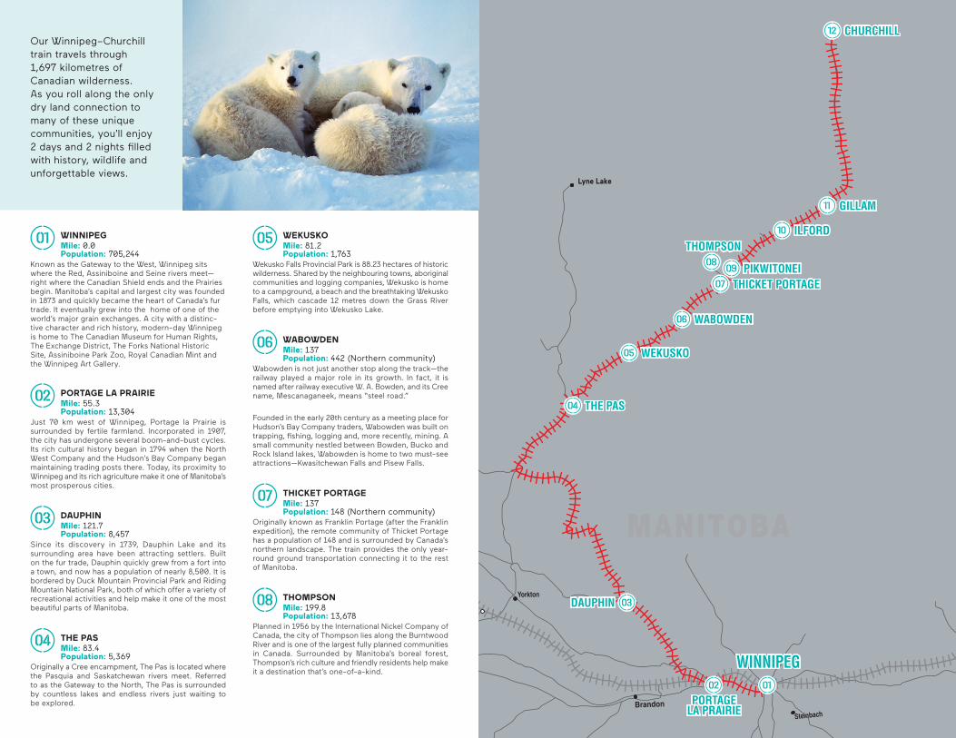
WINNIPEG01 Mile: 0.0
Population: 705,244Known as the Gateway to the West, Winnipeg sits where the Red, Assiniboine and Seine rivers meet—right where the Canadian Shield ends and the Prairies begin. Manitoba’s capital and largest city was founded in 1873 and quickly became the heart of Canada’s fur trade. It eventually grew into the home of one of the world’s major grain exchanges. A city with a distinc-tive character and rich history, modern-day Winnipeg is home to The Canadian Museum for Human Rights, The Exchange District, The Forks National Historic Site, Assiniboine Park Zoo, Royal Canadian Mint and the Winnipeg Art Gallery.
PORTAGE LA PRAIRIE 02 Mile: 55.3
Population: 13,304Just 70 km west of Winnipeg, Portage la Prairie is surrounded by fertile farmland. Incorporated in 1907, the city has undergone several boom-and-bust cycles. Its rich cultural history began in 1794 when the North West Company and the Hudson’s Bay Company began maintaining trading posts there. Today, its proximity to Winnipeg and its rich agriculture make it one of Manitoba’s most prosperous cities.
DAUPHIN03 Mile: 121.7
Population: 8,457Since its discovery in 1739, Dauphin Lake and its surrounding area have been attracting settlers. Built on the fur trade, Dauphin quickly grew from a fort into a town, and now has a population of nearly 8,500. It is bordered by Duck Mountain Provincial Park and Riding Mountain National Park, both of which offer a variety of recreational activities and help make it one of the most beautiful parts of Manitoba.
THE PAS04 Mile: 83.4
Population: 5,369Originally a Cree encampment, The Pas is located where the Pasquia and Saskatchewan rivers meet. Referred to as the Gateway to the North, The Pas is surrounded by countless lakes and endless rivers just waiting to be explored.
WEKUSKO05 Mile: 81.2
Population: 1,763Wekusko Falls Provincial Park is 88.23 hectares of historic wilderness. Shared by the neighbouring towns, aboriginal communities and logging companies, Wekusko is home to a campground, a beach and the breathtaking Wekusko Falls, which cascade 12 metres down the Grass River before emptying into Wekusko Lake.
WABOWDEN06 Mile: 137
Population: 442 (Northern community)Wabowden is not just another stop along the track—the railway played a major role in its growth. In fact, it is named after railway executive W. A. Bowden, and its Cree name, Mescanaganeek, means “steel road.”
Founded in the early 20th century as a meeting place for Hudson’s Bay Company traders, Wabowden was built on trapping, fishing, logging and, more recently, mining. A small community nestled between Bowden, Bucko and Rock Island lakes, Wabowden is home to two must-see attractions—Kwasitchewan Falls and Pisew Falls.
THICKET PORTAGE07 Mile: 137
Population: 148 (Northern community)Originally known as Franklin Portage (after the Franklin expedition), the remote community of Thicket Portage has a population of 148 and is surrounded by Canada’s northern landscape. The train provides the only year-round ground transportation connecting it to the rest of Manitoba.
THOMPSON08 Mile: 199.8
Population: 13,678Planned in 1956 by the International Nickel Company of Canada, the city of Thompson lies along the Burntwood River and is one of the largest fully planned communities in Canada. Surrounded by Manitoba’s boreal forest, Thompson’s rich culture and friendly residents help make it a destination that’s one-of-a-kind.
Our Winnipeg–Churchill train travels through 1,697 kilometres of Canadian wilderness. As you roll along the only dry land connection to many of these unique communities, you’ll enjoy 2 days and 2 nights filled with history, wildlife and unforgettable views.