grand view scenic byway corridor management …€¦ · grand view scenic byway corridor management...
TRANSCRIPT
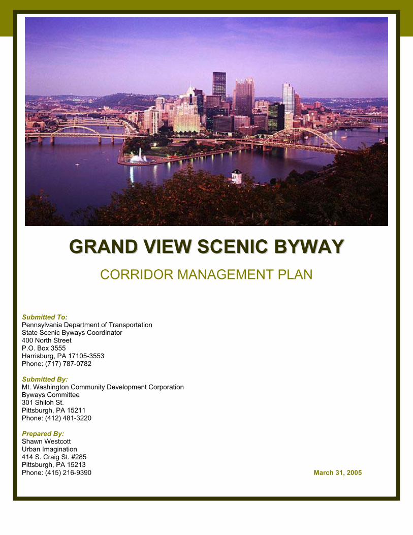
GRAND VIEW SCENIC BYWAY CORRIDOR MANAGEMENT PLAN PAGE 1
GGRRAANNDD VVIIEEWW SSCCEENNIICC BBYYWWAAYY
CORRIDOR MANAGEMENT PLAN Submitted To: Pennsylvania Department of Transportation State Scenic Byways Coordinator 400 North Street P.O. Box 3555 Harrisburg, PA 17105-3553 Phone: (717) 787-0782 Submitted By: Mt. Washington Community Development Corporation Byways Committee 301 Shiloh St. Pittsburgh, PA 15211 Phone: (412) 481-3220 Prepared By: Shawn Westcott Urban Imagination 414 S. Craig St. #285 Pittsburgh, PA 15213 Phone: (415) 216-9390 March 31, 2005
GRAND VIEW SCENIC BYWAY CORRIDOR MANAGEMENT PLAN PAGE 2
TABLE OF CONTENTS Acknowledgements………………………………………………………………..…………… 4 Section I: Introduction…………………………………………………………………………. 5
Vision……………………………………………………………………………………… 6 Mission……………………………………………………………………………………. 6 Goals………………………………………………………………………………………. 6
Section II: Corridor Description……………………………………………………………… 7 Narrative Description of the Byway…………….……………………………………. 7 Existing Zoning…………………………………………………………………………… 10 Land Use………………………………………………………………………………….. 10
Section III: Proximity to Other National Scenic Byways……………………………….. 13 Section IV: Assessment of Traffic, Transit and Other Existing Resources………….. 14
Vehicular Traffic………………………………………………………………………….. 14 Traffic Counts…………………………………………………………………………….. 14 Safety Records and Potential Hazards……………………………………………….. 14 Accommodations by Traffic Type……………………………………………………… 15 Connection to Public Transit…………………………………………………………… 15 Inclines…………………………………………………………………………………….. 15 Signage and Compliance with Regulations………………………………………….. 15 Parking……………………………………………………………………………………. 16 Amenities…………………………………………………………………………………. 16 Outdoor Advertising…………………………………………………………………….. 17 Overlooks…………………………………………………………………………………. 17
Section V: Community Planning Process………………………………………………….. 18 Summary of Past Community Work…………………………………………………… 18 Current Program Overview……………………………………………………………… 19 Notification and Public Information…………………………………………………….. 19 Community Participation Survey……………………………………………………….. 20 Next Steps………………………………………………………………………………… 20
Section VI: Intrinsic Qualities……………………………………………………………….... 22 Intrinsic Quality One: Scenic……………………………………………………………. 22
Early History of the “Vista” ……………………………………………………… 22 A Growing Appreciation for the View…………………………………………... 23 The View Today………………………………………………………………….. 24
Intrinsic Quality Two: Historic………………………………………………………….. 27 Early History……………………………………………………………………… 27 Coal Hill…………………………………………………………………………… 29 Industrial Revolution…………………………………………………………….. 30 Growth and Environmental Clean Up………………………………………….. 32 The Evolution from Coal Hill to a Neighborhood……………………………… 34 Library……………………………………………………………………………... 35
Intrinsic Quality Three: Recreational…………………………………………………… 36 Street Life…………………………………………………………………………. 36 Uses……………………………………………………………………………….. 37
Section VII: Strategy for Maintaining and Enhancing the Byway and Its Intrinsic Qualities……………………………………………………… 39
Goal 1: Create a Warm and Welcoming Visitor Experience………………………… 39
GRAND VIEW SCENIC BYWAY CORRIDOR MANAGEMENT PLAN PAGE 3
Goal 2: Preserve and Enhance Green Space………………………………………… 41 Goal 3: Develop Overall Cohesive and Cooperative Design Plan………………… 41 Goal 4: Improve the Infrastructure of the Byway…………………………………… 42 Goal 5: Ensure Continual Community Participation in the Process………………… 43
Section VIII: Works In Progress…………………………………………………………….. 44 Existing Plans for Renovations & Improvements………..………………………..... 45
Section IX: Tourist and Business Development………………………………………….. 47 Communications Plan…………………………………………………………………… 47 Marketing and Promotions.……………………………………………………………… 47 Byway Beneficiaries……………………………………………………………………… 48
Appendices 1. Byway Maps 2. List of Byway Stakeholders and Businesses 3. Emerald Link Scope Plan 4. Action Plan 5. Letters of Support
GRAND VIEW SCENIC BYWAY CORRIDOR MANAGEMENT PLAN PAGE 4
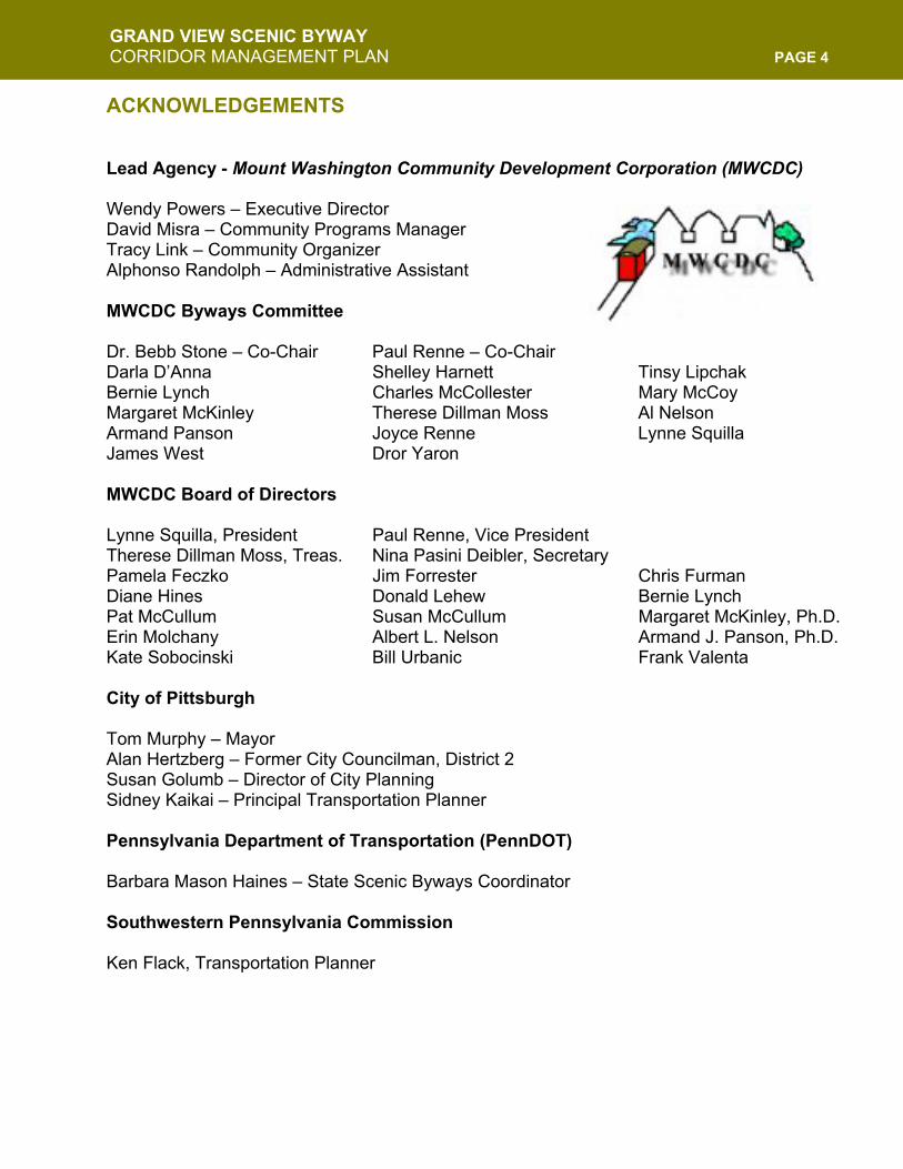
ACKNOWLEDGEMENTS Lead Agency - Mount Washington Community Development Corporation (MWCDC)
Wendy Powers – Executive Director David Misra – Community Programs Manager Tracy Link – Community Organizer Alphonso Randolph – Administrative Assistant MWCDC Byways Committee
Dr. Bebb Stone – Co-Chair Paul Renne – Co-Chair Darla D’Anna Shelley Harnett Tinsy Lipchak Bernie Lynch Charles McCollester Mary McCoy Margaret McKinley Therese Dillman Moss Al Nelson Armand Panson Joyce Renne Lynne Squilla James West Dror Yaron MWCDC Board of Directors
Lynne Squilla, President Paul Renne, Vice President Therese Dillman Moss, Treas. Nina Pasini Deibler, Secretary Pamela Feczko Jim Forrester Chris Furman Diane Hines Donald Lehew Bernie Lynch Pat McCullum Susan McCullum Margaret McKinley, Ph.D. Erin Molchany Albert L. Nelson Armand J. Panson, Ph.D. Kate Sobocinski Bill Urbanic Frank Valenta City of Pittsburgh
Tom Murphy – Mayor Alan Hertzberg – Former City Councilman, District 2 Susan Golumb – Director of City Planning Sidney Kaikai – Principal Transportation Planner Pennsylvania Department of Transportation (PennDOT)
Barbara Mason Haines – State Scenic Byways Coordinator Southwestern Pennsylvania Commission Ken Flack, Transportation Planner
GRAND VIEW SCENIC BYWAY CORRIDOR MANAGEMENT PLAN PAGE 5
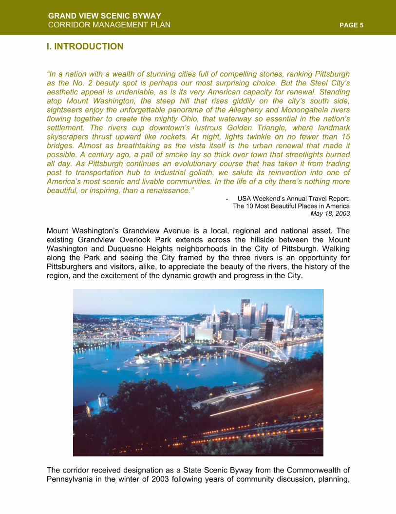
I. INTRODUCTION “In a nation with a wealth of stunning cities full of compelling stories, ranking Pittsburgh as the No. 2 beauty spot is perhaps our most surprising choice. But the Steel City’s aesthetic appeal is undeniable, as is its very American capacity for renewal. Standing atop Mount Washington, the steep hill that rises giddily on the city’s south side, sightseers enjoy the unforgettable panorama of the Allegheny and Monongahela rivers flowing together to create the mighty Ohio, that waterway so essential in the nation’s settlement. The rivers cup downtown’s lustrous Golden Triangle, where landmark skyscrapers thrust upward like rockets. At night, lights twinkle on no fewer than 15 bridges. Almost as breathtaking as the vista itself is the urban renewal that made it possible. A century ago, a pall of smoke lay so thick over town that streetlights burned all day. As Pittsburgh continues an evolutionary course that has taken it from trading post to transportation hub to industrial goliath, we salute its reinvention into one of America’s most scenic and livable communities. In the life of a city there’s nothing more beautiful, or inspiring, than a renaissance.”
- USA Weekend’s Annual Travel Report: The 10 Most Beautiful Places in America
May 18, 2003
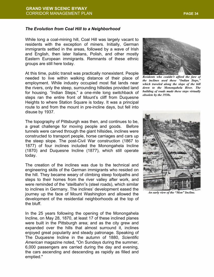
Mount Washington’s Grandview Avenue is a local, regional and national asset. The existing Grandview Overlook Park extends across the hillside between the Mount Washington and Duquesne Heights neighborhoods in the City of Pittsburgh. Walking along the Park and seeing the City framed by the three rivers is an opportunity for Pittsburghers and visitors, alike, to appreciate the beauty of the rivers, the history of the region, and the excitement of the dynamic growth and progress in the City.
The corridor received designation as a State Scenic Byway from the Commonwealth of Pennsylvania in the winter of 2003 following years of community discussion, planning,
GRAND VIEW SCENIC BYWAY CORRIDOR MANAGEMENT PLAN PAGE 6
and subsequent legislation and development. Beloved by locals and visitors alike, the Byway serves as Pittsburgh’s “front porch” and is a major regional destination for tourists and residents, who consider it one of the most special places in the city. The Lead Agency for this project has been the Mount Washington Community Development Corporation (MWCDC). Formed in 1990 in response to the need for a centralized group to oversee the continuing development for the neighborhoods, MWCDC has facilitated community meetings and served as the recipient organization for funds to improve the corridor and, now, the Byway. Throughout the community planning process, the Byway Committee of the Mount Washington Community Development Corporation followed a guiding vision and mission.
Mission: To preserve, enhance and improve the Grand View Scenic Byway’s intrinsic historical, scenic, recreational and economic assets to secure it as an international destination that benefits residents and visitors alike now and for future generations. Vision: To capitalize on the uniqueness of a series of Pittsburgh roadways so that they will attract regional, national, and international visitors through their vibrant combination of scenery, views and history, as well as recreational and commercial opportunities.
The committee and community participants have addressed corridor improvements and created short- and long-term strategies for success, which fall under five general goals:
1. Create a warm and welcoming visitor experience 2. Preserve and enhance green space 3. Develop overall cohesive and cooperative design plan 4. Improve the infrastructure of the Byway 5. Ensure continual community participation
This Corridor Management Plan (CMP) has been developed to maintain the corridor and establish a system for management and upkeep. The CMP has relied on intensive public process with a thorough evaluation of the corridor’s needs. Fundraising and partnership opportunities have been established, along with roadway safety, maintenance, transportation, and pedestrian needs. Additionally, an ongoing review of these aspects has been put in place.
The goal of the CMP is to preserve, enhance, and improve the three intrinsic qualities (scenic, historic, and recreational) that contribute to the essence of the urban Byway experience. By highlighting past successes and demonstrating future potential, we will demonstrate why the Grand View Scenic Byway deserves distinction as a National Byway.
GRAND VIEW SCENIC BYWAY CORRIDOR MANAGEMENT PLAN PAGE 7
II. CORRIDOR DESCRIPTION NARRATIVE DESCRIPTION OF THE BYWAY The Grand View State Scenic Byway is located in Pittsburgh, Pennsylvania in the neighborhoods of Mt. Washington and Duquesne Heights, due south of the city’s Downtown. The Byway is situated above the confluence of the Monongahela and Allegheny rivers, which come together to form the Ohio River. The Byway is composed of three separate (but adjoining) roads:
Grandview Avenue (locally-owned) Location of Road: City of Pittsburgh, Mt. Washington and Duquesne Heights neighborhoods Beginning Terminus: Republic Street Ending Terminus: Wyoming Street Approximate Length of Byway Section: 1.25 miles Width of Byway Section: Two-lanes
McArdle Roadway (locally-owned) Location of Road: City of Pittsburgh, Mt. Washington & South Side neighborhoods Beginning Terminus: Grandview Avenue Ending Terminus: 10th Street Approximate Length of Byway Section: 1.25 miles Width of Byway Section: Two-lanes East Sycamore Street (locally-owned) Location of Road: City of Pittsburgh, Mt. Washington neighborhood Beginning Terminus: Wyoming Street @ Grandview Ending Terminus: Arlington @ Carson Approximate Length of Byway Section: 0.5 miles Width of Byway Section: Two-lanes
For the purpose of this description, the Byway is divided into eight different segments: six segments on Grandview Avenue and one each on McArdle and Sycamore. Each segment differs in urban form, occupancy and character from the others. In addition there are three intersections along Grandview Avenue, which are important points of reference. The following descriptions broadly characterize the areas of interest: The West End Terminus: The west end of Grandview Avenue is marked by Grandview Towers, an eleven-story apartment building. This building caps the view at the end of the street and reinforces the cart way’s change of direction as Grandview turns into Republic Street. In order to loop around for a return trip, visitors can follow Grandview to the left onto Republic Street. A second left onto Rutledge Street and a third left on Shaler Street brings a driver back to the Byway.
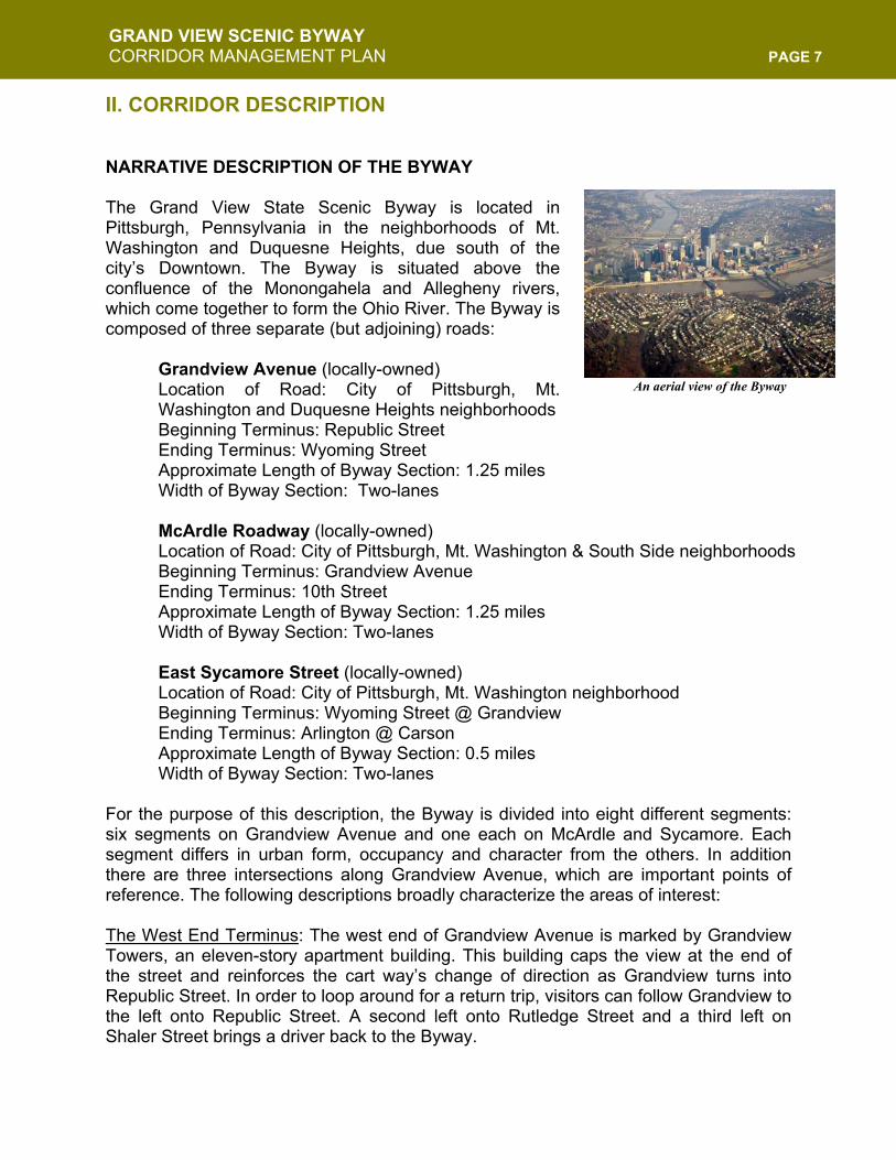
An aerial view of the Byway
GRAND VIEW SCENIC BYWAY CORRIDOR MANAGEMENT PLAN PAGE 8
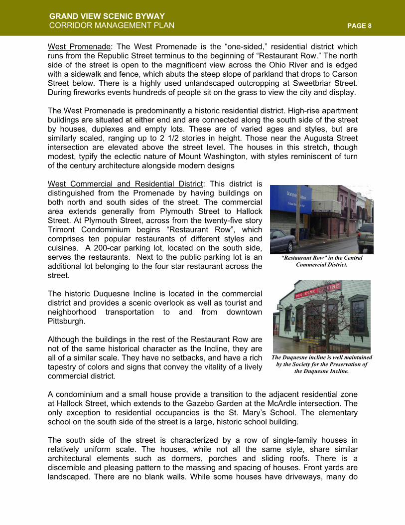
West Promenade: The West Promenade is the “one-sided,” residential district which runs from the Republic Street terminus to the beginning of “Restaurant Row.” The north side of the street is open to the magnificent view across the Ohio River and is edged with a sidewalk and fence, which abuts the steep slope of parkland that drops to Carson Street below. There is a highly used unlandscaped outcropping at Sweetbriar Street. During fireworks events hundreds of people sit on the grass to view the city and display. The West Promenade is predominantly a historic residential district. High-rise apartment buildings are situated at either end and are connected along the south side of the street by houses, duplexes and empty lots. These are of varied ages and styles, but are similarly scaled, ranging up to 2 1/2 stories in height. Those near the Augusta Street intersection are elevated above the street level. The houses in this stretch, though modest, typify the eclectic nature of Mount Washington, with styles reminiscent of turn of the century architecture alongside modern designs West Commercial and Residential District: This district is distinguished from the Promenade by having buildings on both north and south sides of the street. The commercial area extends generally from Plymouth Street to Hallock Street. At Plymouth Street, across from the twenty-five story Trimont Condominium begins “Restaurant Row”, which comprises ten popular restaurants of different styles and cuisines. A 200-car parking lot, located on the south side, serves the restaurants. Next to the public parking lot is an additional lot belonging to the four star restaurant across the street. The historic Duquesne Incline is located in the commercial district and provides a scenic overlook as well as tourist and neighborhood transportation to and from downtown Pittsburgh. Although the buildings in the rest of the Restaurant Row are not of the same historical character as the Incline, they are all of a similar scale. They have no setbacks, and have a rich tapestry of colors and signs that convey the vitality of a lively commercial district. A condominium and a small house provide a transition to the adjacent residential zone at Hallock Street, which extends to the Gazebo Garden at the McArdle intersection. The only exception to residential occupancies is the St. Mary’s School. The elementary school on the south side of the street is a large, historic school building. The south side of the street is characterized by a row of single-family houses in relatively uniform scale. The houses, while not all the same style, share similar architectural elements such as dormers, porches and sliding roofs. There is a discernible and pleasing pattern to the massing and spacing of houses. Front yards are landscaped. There are no blank walls. While some houses have driveways, many do
“Restaurant Row” in the Central Commercial District.
The Duquesne incline is well maintained
by the Society for the Preservation of the Duquesne Incline.
GRAND VIEW SCENIC BYWAY CORRIDOR MANAGEMENT PLAN PAGE 9
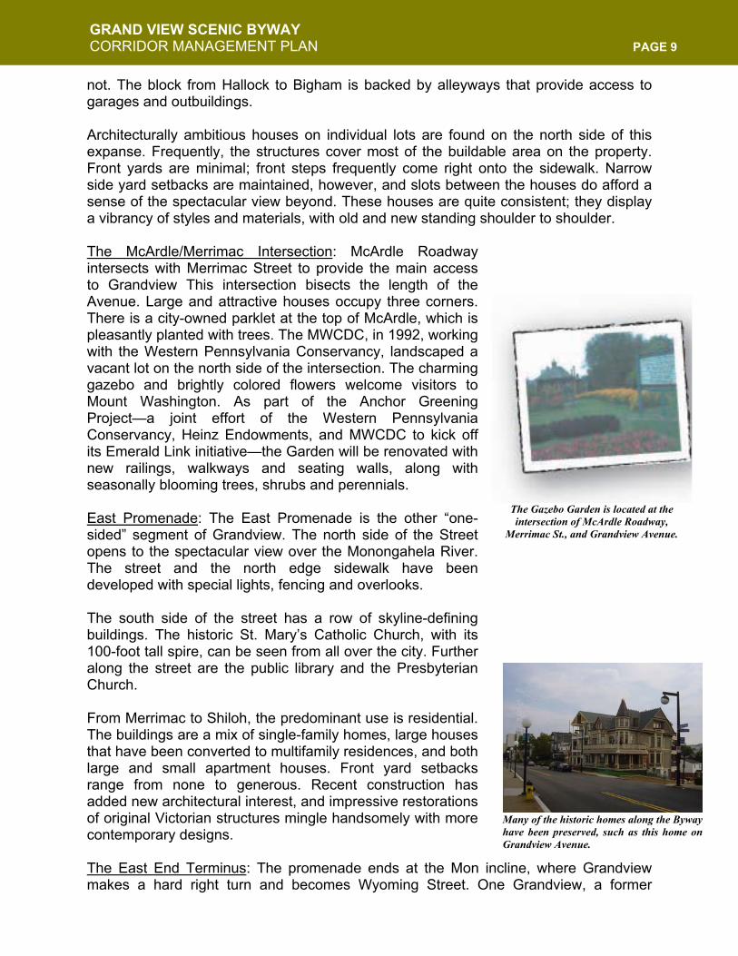
not. The block from Hallock to Bigham is backed by alleyways that provide access to garages and outbuildings. Architecturally ambitious houses on individual lots are found on the north side of this expanse. Frequently, the structures cover most of the buildable area on the property. Front yards are minimal; front steps frequently come right onto the sidewalk. Narrow side yard setbacks are maintained, however, and slots between the houses do afford a sense of the spectacular view beyond. These houses are quite consistent; they display a vibrancy of styles and materials, with old and new standing shoulder to shoulder. The McArdle/Merrimac Intersection: McArdle Roadway intersects with Merrimac Street to provide the main access to Grandview This intersection bisects the length of the Avenue. Large and attractive houses occupy three corners. There is a city-owned parklet at the top of McArdle, which is pleasantly planted with trees. The MWCDC, in 1992, working with the Western Pennsylvania Conservancy, landscaped a vacant lot on the north side of the intersection. The charming gazebo and brightly colored flowers welcome visitors to Mount Washington. As part of the Anchor Greening Project—a joint effort of the Western Pennsylvania Conservancy, Heinz Endowments, and MWCDC to kick off its Emerald Link initiative—the Garden will be renovated with new railings, walkways and seating walls, along with seasonally blooming trees, shrubs and perennials. East Promenade: The East Promenade is the other “one-sided” segment of Grandview. The north side of the Street opens to the spectacular view over the Monongahela River. The street and the north edge sidewalk have been developed with special lights, fencing and overlooks. The south side of the street has a row of skyline-defining buildings. The historic St. Mary’s Catholic Church, with its 100-foot tall spire, can be seen from all over the city. Further along the street are the public library and the Presbyterian Church. From Merrimac to Shiloh, the predominant use is residential. The buildings are a mix of single-family homes, large houses that have been converted to multifamily residences, and both large and small apartment houses. Front yard setbacks range from none to generous. Recent construction has added new architectural interest, and impressive restorations of original Victorian structures mingle handsomely with more contemporary designs. The East End Terminus: The promenade ends at the Mon incline, where Grandview makes a hard right turn and becomes Wyoming Street. One Grandview, a former
The Gazebo Garden is located at the intersection of McArdle Roadway,
Merrimac St., and Grandview Avenue.
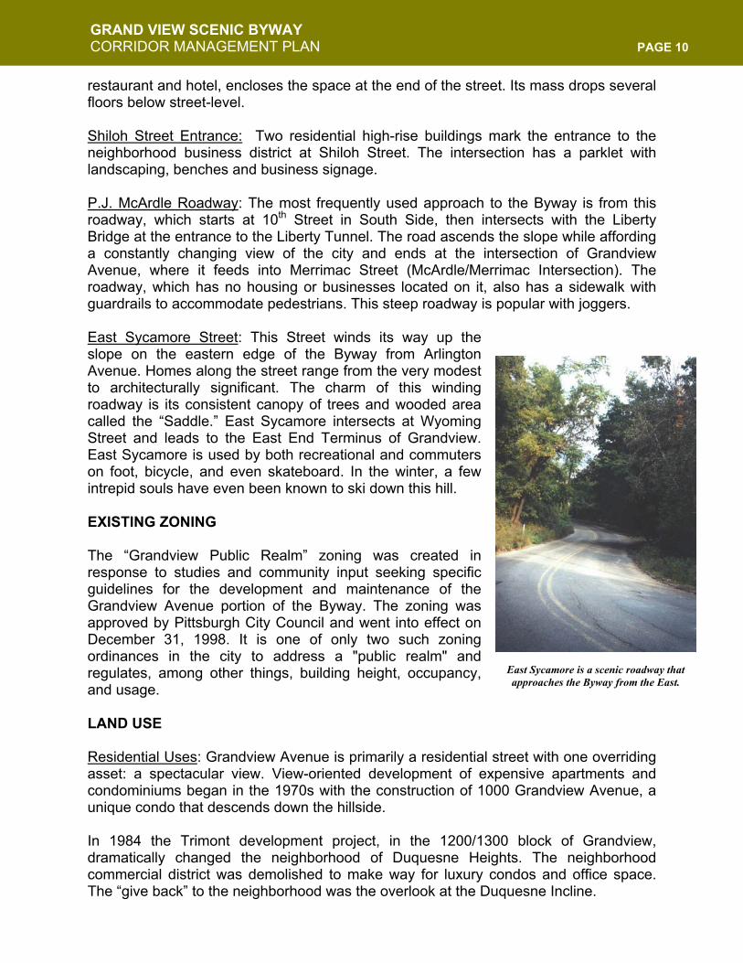
Many of the historic homes along the Bywayhave been preserved, such as this home onGrandview Avenue.
GRAND VIEW SCENIC BYWAY CORRIDOR MANAGEMENT PLAN PAGE 10
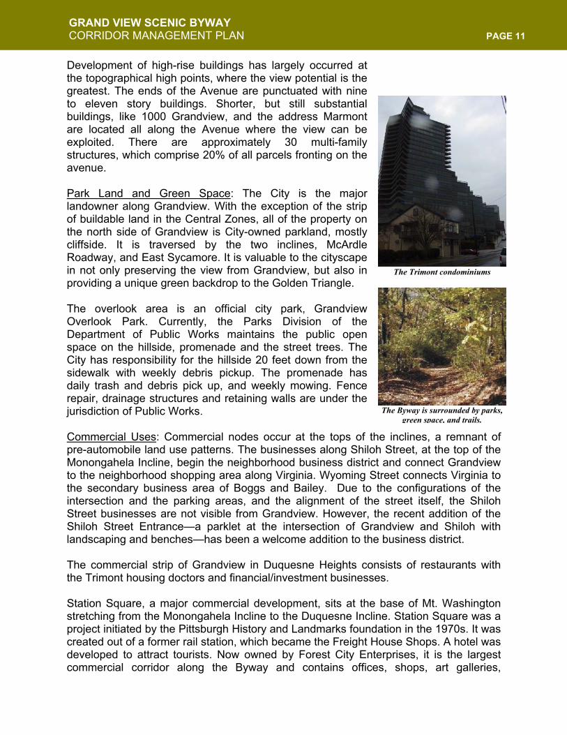
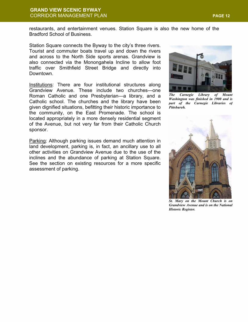
restaurant and hotel, encloses the space at the end of the street. Its mass drops several floors below street-level. Shiloh Street Entrance: Two residential high-rise buildings mark the entrance to the neighborhood business district at Shiloh Street. The intersection has a parklet with landscaping, benches and business signage. P.J. McArdle Roadway: The most frequently used approach to the Byway is from this roadway, which starts at 10th Street in South Side, then intersects with the Liberty Bridge at the entrance to the Liberty Tunnel. The road ascends the slope while affording a constantly changing view of the city and ends at the intersection of Grandview Avenue, where it feeds into Merrimac Street (McArdle/Merrimac Intersection). The roadway, which has no housing or businesses located on it, also has a sidewalk with guardrails to accommodate pedestrians. This steep roadway is popular with joggers. East Sycamore Street: This Street winds its way up the slope on the eastern edge of the Byway from Arlington Avenue. Homes along the street range from the very modest to architecturally significant. The charm of this winding roadway is its consistent canopy of trees and wooded area called the “Saddle.” East Sycamore intersects at Wyoming Street and leads to the East End Terminus of Grandview. East Sycamore is used by both recreational and commuters on foot, bicycle, and even skateboard. In the winter, a few intrepid souls have even been known to ski down this hill. EXISTING ZONING The “Grandview Public Realm” zoning was created in response to studies and community input seeking specific guidelines for the development and maintenance of the Grandview Avenue portion of the Byway. The zoning was approved by Pittsburgh City Council and went into effect on December 31, 1998. It is one of only two such zoning ordinances in the city to address a "public realm" and regulates, among other things, building height, occupancy, and usage. LAND USE Residential Uses: Grandview Avenue is primarily a residential street with one overriding asset: a spectacular view. View-oriented development of expensive apartments and condominiums began in the 1970s with the construction of 1000 Grandview Avenue, a unique condo that descends down the hillside. In 1984 the Trimont development project, in the 1200/1300 block of Grandview, dramatically changed the neighborhood of Duquesne Heights. The neighborhood commercial district was demolished to make way for luxury condos and office space. The “give back” to the neighborhood was the overlook at the Duquesne Incline.
East Sycamore is a scenic roadway that approaches the Byway from the East.
GRAND VIEW SCENIC BYWAY CORRIDOR MANAGEMENT PLAN PAGE 11
Development of high-rise buildings has largely occurred at the topographical high points, where the view potential is the greatest. The ends of the Avenue are punctuated with nine to eleven story buildings. Shorter, but still substantial buildings, like 1000 Grandview, and the address Marmont are located all along the Avenue where the view can be exploited. There are approximately 30 multi-family structures, which comprise 20% of all parcels fronting on the avenue. Park Land and Green Space: The City is the major landowner along Grandview. With the exception of the strip of buildable land in the Central Zones, all of the property on the north side of Grandview is City-owned parkland, mostly cliffside. It is traversed by the two inclines, McArdle Roadway, and East Sycamore. It is valuable to the cityscape in not only preserving the view from Grandview, but also in providing a unique green backdrop to the Golden Triangle. The overlook area is an official city park, Grandview Overlook Park. Currently, the Parks Division of the Department of Public Works maintains the public open space on the hillside, promenade and the street trees. The City has responsibility for the hillside 20 feet down from the sidewalk with weekly debris pickup. The promenade has daily trash and debris pick up, and weekly mowing. Fence repair, drainage structures and retaining walls are under the jurisdiction of Public Works. Commercial Uses: Commercial nodes occur at the tops of the inclines, a remnant of pre-automobile land use patterns. The businesses along Shiloh Street, at the top of the Monongahela Incline, begin the neighborhood business district and connect Grandview to the neighborhood shopping area along Virginia. Wyoming Street connects Virginia to the secondary business area of Boggs and Bailey. Due to the configurations of the intersection and the parking areas, and the alignment of the street itself, the Shiloh Street businesses are not visible from Grandview. However, the recent addition of the Shiloh Street Entrance—a parklet at the intersection of Grandview and Shiloh with landscaping and benches—has been a welcome addition to the business district. The commercial strip of Grandview in Duquesne Heights consists of restaurants with the Trimont housing doctors and financial/investment businesses. Station Square, a major commercial development, sits at the base of Mt. Washington stretching from the Monongahela Incline to the Duquesne Incline. Station Square was a project initiated by the Pittsburgh History and Landmarks foundation in the 1970s. It was created out of a former rail station, which became the Freight House Shops. A hotel was developed to attract tourists. Now owned by Forest City Enterprises, it is the largest commercial corridor along the Byway and contains offices, shops, art galleries,
The Trimont condominiums
The Byway is surrounded by parks, green space, and trails.
GRAND VIEW SCENIC BYWAY CORRIDOR MANAGEMENT PLAN PAGE 12
restaurants, and entertainment venues. Station Square is also the new home of the Bradford School of Business. Station Square connects the Byway to the city’s three rivers. Tourist and commuter boats travel up and down the rivers and across to the North Side sports arenas. Grandview is also connected via the Monongahela Incline to allow foot traffic over Smithfield Street Bridge and directly into Downtown. Institutions: There are four institutional structures along Grandview Avenue. These include two churches—one Roman Catholic and one Presbyterian—a library, and a Catholic school. The churches and the library have been given dignified situations, befitting their historic importance to the community, on the East Promenade. The school is located appropriately in a more densely residential segment of the Avenue, but not very far from their Catholic Church sponsor. Parking: Although parking issues demand much attention in land development, parking is, in fact, an ancillary use to all other activities on Grandview Avenue due to the use of the inclines and the abundance of parking at Station Square. See the section on existing resources for a more specific assessment of parking.
The Carnegie Library of MountWashington was finished in 1900 and ispart of the Carnegie Libraries ofPittsburgh.
St. Mary on the Mount Church is onGrandview Avenue and is on the NationalHistoric Register.
GRAND VIEW SCENIC BYWAY CORRIDOR MANAGEMENT PLAN PAGE 13
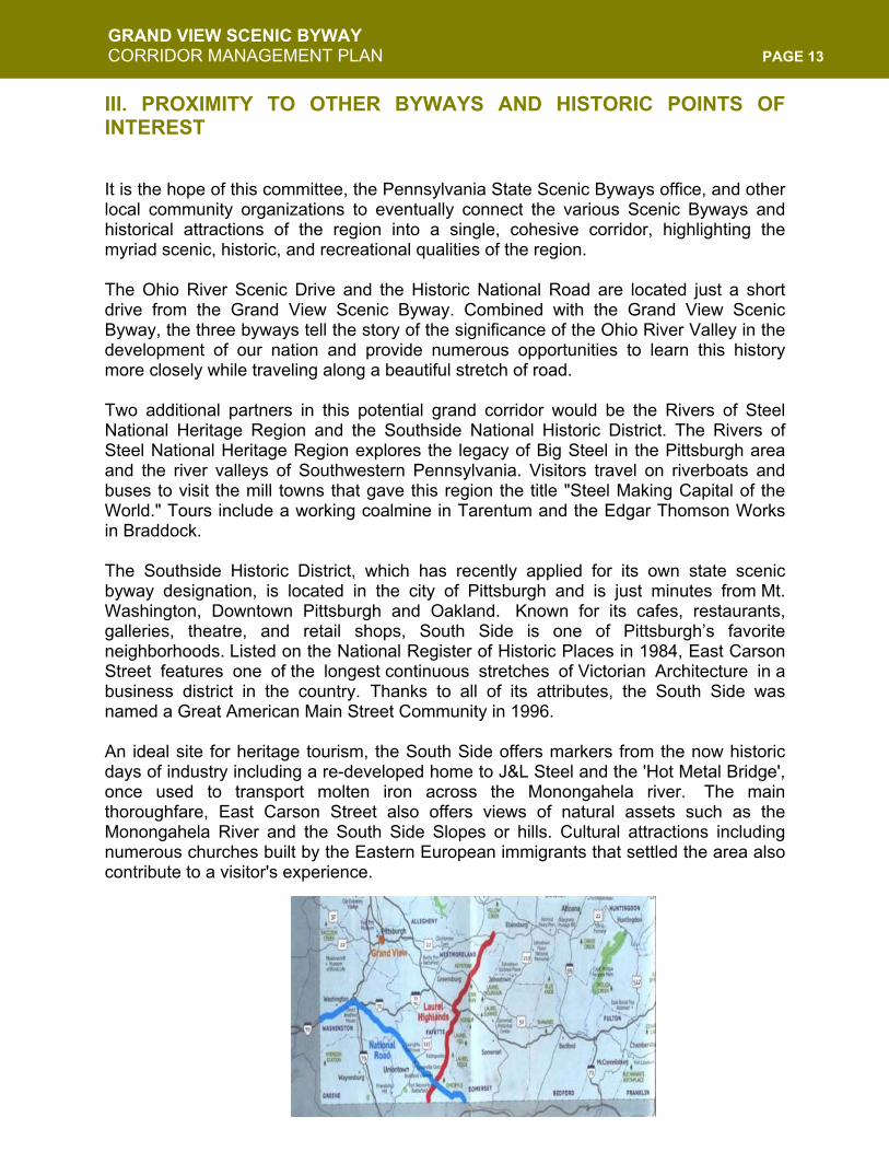
III. PROXIMITY TO OTHER BYWAYS AND HISTORIC POINTS OF INTEREST It is the hope of this committee, the Pennsylvania State Scenic Byways office, and other local community organizations to eventually connect the various Scenic Byways and historical attractions of the region into a single, cohesive corridor, highlighting the myriad scenic, historic, and recreational qualities of the region. The Ohio River Scenic Drive and the Historic National Road are located just a short drive from the Grand View Scenic Byway. Combined with the Grand View Scenic Byway, the three byways tell the story of the significance of the Ohio River Valley in the development of our nation and provide numerous opportunities to learn this history more closely while traveling along a beautiful stretch of road. Two additional partners in this potential grand corridor would be the Rivers of Steel National Heritage Region and the Southside National Historic District. The Rivers of Steel National Heritage Region explores the legacy of Big Steel in the Pittsburgh area and the river valleys of Southwestern Pennsylvania. Visitors travel on riverboats and buses to visit the mill towns that gave this region the title "Steel Making Capital of the World." Tours include a working coalmine in Tarentum and the Edgar Thomson Works in Braddock. The Southside Historic District, which has recently applied for its own state scenic byway designation, is located in the city of Pittsburgh and is just minutes from Mt. Washington, Downtown Pittsburgh and Oakland. Known for its cafes, restaurants, galleries, theatre, and retail shops, South Side is one of Pittsburgh’s favorite neighborhoods. Listed on the National Register of Historic Places in 1984, East Carson Street features one of the longest continuous stretches of Victorian Architecture in a business district in the country. Thanks to all of its attributes, the South Side was named a Great American Main Street Community in 1996. An ideal site for heritage tourism, the South Side offers markers from the now historic days of industry including a re-developed home to J&L Steel and the 'Hot Metal Bridge', once used to transport molten iron across the Monongahela river. The main thoroughfare, East Carson Street also offers views of natural assets such as the Monongahela River and the South Side Slopes or hills. Cultural attractions including numerous churches built by the Eastern European immigrants that settled the area also contribute to a visitor's experience.
GRAND VIEW SCENIC BYWAY CORRIDOR MANAGEMENT PLAN PAGE 14
IV. ASSESSMENT OF TRAFFIC, TRANSIT, AND OTHER EXISTING RESOURCES
VEHICULAR TRAFFIC The corridor, as is, can reasonably accommodate cars, trucks, buses, motorcycles, bicycles, and pedestrian traffic, along with local commercial traffic. The major access point to the Avenue is at the P.J. McArdle/Merrimac Street intersection. Lesser access routes are Sycamore Street on the east end, and Shaler and Greenleaf Streets on the west end. Grandview is a major east-west neighborhood route, and in fact is the only east-west route at the western end. Virginia Avenue, although a strong connector in the eastern end, does not continue past Plymouth Street. The inclines provide pedestrian access points, particularly serving commuters to Downtown and sightseers arriving from Station Square and by tour buses. TRAFFIC COUNTS In October of 2004, the Southwestern Pennsylvania Commission (SPC), on a request from the Mount Washington Community Development Corporation, conducted a one-day traffic count program for the purpose of this Corridor Management Plan. Below is a summation of the SPC’s results.
McArdle Roadway Location Tested: Btwn. Grandview Ave. & Liberty Bridge Count: 11,756 Total (4,665 eastbound, 7,091 westbound) McArdle Roadway Location Tested: Btwn. Arlington Ave. and S. 10th St. Count: 7,025 Total (3,731 eastbound, 3,294 westbound) E. Sycamore Street Location Tested: Btwn. Wyoming St. and Arlington Ave. Count: 2,232 Total (2,232 for both directions)
SAFETY RECORDS AND POTENTIAL HAZARDS Given the large volume of both pedestrians and vehicles in such a confined area, there have been surprisingly few injuries due to accidents over a three-year period. However, the biggest risks that exist along the corridor involve accidents from icy road surfaces on McArdle and E. Sycamore, and pedestrian safety accidents, mainly low speed accidents from crossing streets and falls from the edge of the slope. In order to reduce the number of accidents and injuries—especially pedestrian—along the Byway, several improvements and enhancements should be installed. These include upgrading railings along the overlooks, updating and extending crosswalks and
GRAND VIEW SCENIC BYWAY CORRIDOR MANAGEMENT PLAN PAGE 15
sidewalks, walking paths, bike paths, and bus pullouts; and installing and extending architectural elements, such as transit shelters, trash receptacles, and lighting, as well as the drainage system on the Byway. Further recommendations can be found in Section VII. CONNECTION TO PUBLIC TRANSIT The Grand View Scenic Byway is the only corridor in the entire city served by every mode of public transit available. The region’s Port Authority Transit system (PAT) operates a diverse public transit network connecting the Byway to the city and surrounding communities. The system includes regular bus routes and a light rail system (known as the T), which can be accessed at the base of the slope. The T connects travelers to Downtown and the South Hills. The rail line travels underneath the Byway through the McArdle tunnel. In addition, PAT operates the Monongahela Incline, which is one of the two active inclines in the city. The second incline—the Duquesne Incline—is privately operated by the Society for the Preservation of the Duquesne Incline.
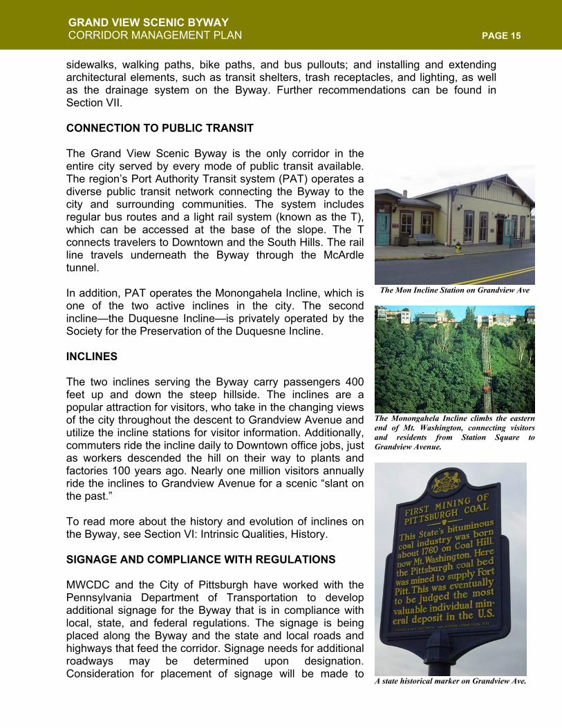
INCLINES The two inclines serving the Byway carry passengers 400 feet up and down the steep hillside. The inclines are a popular attraction for visitors, who take in the changing views of the city throughout the descent to Grandview Avenue and utilize the incline stations for visitor information. Additionally, commuters ride the incline daily to Downtown office jobs, just as workers descended the hill on their way to plants and factories 100 years ago. Nearly one million visitors annually ride the inclines to Grandview Avenue for a scenic “slant on the past.” To read more about the history and evolution of inclines on the Byway, see Section VI: Intrinsic Qualities, History. SIGNAGE AND COMPLIANCE WITH REGULATIONS MWCDC and the City of Pittsburgh have worked with the Pennsylvania Department of Transportation to develop additional signage for the Byway that is in compliance with local, state, and federal regulations. The signage is being placed along the Byway and the state and local roads and highways that feed the corridor. Signage needs for additional roadways may be determined upon designation. Consideration for placement of signage will be made to
The Mon Incline Station on Grandview Ave
The Monongahela Incline climbs the easternend of Mt. Washington, connecting visitorsand residents from Station Square toGrandview Avenue.
A state historical marker on Grandview Ave.
GRAND VIEW SCENIC BYWAY CORRIDOR MANAGEMENT PLAN PAGE 16
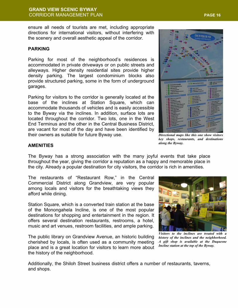
ensure all needs of tourists are met, including appropriate directions for international visitors, without interfering with the scenery and overall aesthetic appeal of the corridor. PARKING Parking for most of the neighborhood’s residences is accommodated in private driveways or on public streets and alleyways. Higher density residential sites provide higher density parking. The largest condominium blocks also provide structured parking, some in the form of underground garages. Parking for visitors to the corridor is generally located at the base of the inclines at Station Square, which can accommodate thousands of vehicles and is easily accessible to the Byway via the inclines. In addition, surface lots are located throughout the corridor. Two lots, one in the West End Terminus and the other in the Central Business District, are vacant for most of the day and have been identified by their owners as suitable for future Byway use. AMENITIES The Byway has a strong association with the many joyful events that take place throughout the year, giving the corridor a reputation as a happy and memorable place in the city. Already a popular destination for city visitors, the corridor is rich in amenities. The restaurants of “Restaurant Row,” in the Central Commercial District along Grandview, are very popular among locals and visitors for the breathtaking views they afford while dining. Station Square, which is a converted train station at the base of the Monongahela Incline, is one of the most popular destinations for shopping and entertainment in the region. It offers several destination restaurants, restrooms, a hotel, music and art venues, restroom facilities, and ample parking. The public library on Grandview Avenue, an historic building cherished by locals, is often used as a community meeting place and is a great location for visitors to learn more about the history of the neighborhood. Additionally, the Shiloh Street business district offers a number of restaurants, taverns, and shops.
Visitors to the inclines are treated with ahistory of the inclines and the neighborhood.A gift shop is available at the DuquesneIncline station at the top of the Byway.
Directional maps like this one show visitorskey shops, restaurants, and destinationsalong the Byway.
GRAND VIEW SCENIC BYWAY CORRIDOR MANAGEMENT PLAN PAGE 17
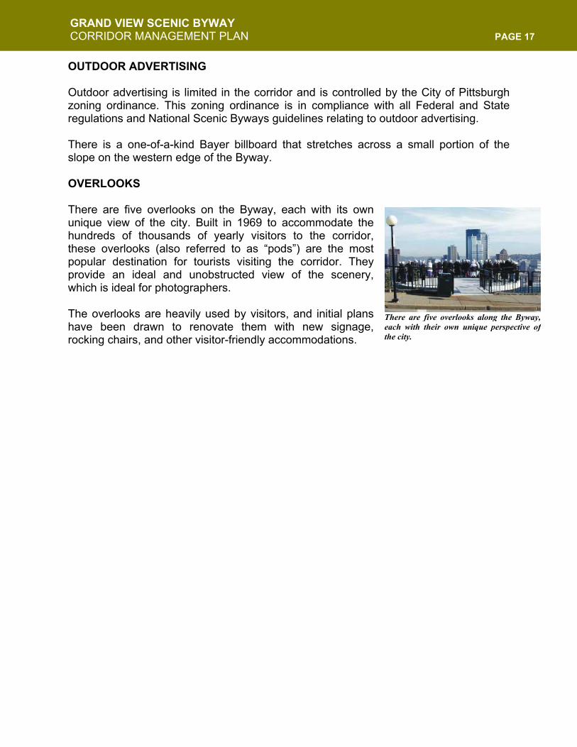
OUTDOOR ADVERTISING Outdoor advertising is limited in the corridor and is controlled by the City of Pittsburgh zoning ordinance. This zoning ordinance is in compliance with all Federal and State regulations and National Scenic Byways guidelines relating to outdoor advertising. There is a one-of-a-kind Bayer billboard that stretches across a small portion of the slope on the western edge of the Byway. OVERLOOKS There are five overlooks on the Byway, each with its own unique view of the city. Built in 1969 to accommodate the hundreds of thousands of yearly visitors to the corridor, these overlooks (also referred to as “pods”) are the most popular destination for tourists visiting the corridor. They provide an ideal and unobstructed view of the scenery, which is ideal for photographers. The overlooks are heavily used by visitors, and initial plans have been drawn to renovate them with new signage, rocking chairs, and other visitor-friendly accommodations.
There are five overlooks along the Byway,each with their own unique perspective ofthe city.
GRAND VIEW SCENIC BYWAY CORRIDOR MANAGEMENT PLAN PAGE 18
V. COMMUNITY PLANNING PROCESS The Lead Agency for this project has been the Mount Washington Community Development Corporation (MWCDC). Founded in 1990 as a 501(c)(3) community-based organization, MWCDC promotes the interests of Mount Washington and Duquesne Heights citizens, institutions, businesses and investors. Its mission is focus on issues vital to the community well being while involving residents, homeowners, property owners, businesses, and institutions within the community. The organizational goals are to:
- Preserve and enhance the neighborhood and its institutions. - Promote environmental, visual and physical improvements. - Conduct master planning for neighborhood improvements. - Provide forums for community involvement in neighborhood
improvements and development. MWCDC has facilitated community meetings and served as the recipient organization for funds relating to the improvement of the corridor. Since the success of the Byway relies on community driven action, MWCDC convened a Scenic Byway Committee made up of volunteers and representatives of stakeholder organizations. The committee was formed to oversee the more detailed aspects of the community process and to ensure the ongoing stewardship of the Byway. The committee held its first meeting on June 7, 2004 and has since taken several steps to encourage partnering, community involvement, and consensus building. The Committee’s meetings are open to the public and any interested party is invited to become a member. SUMMARY OF PAST COMMUNITY WORK Realizing the great economic potential of this regional asset, the City has been planning, since 1992, to upgrade Grandview Avenue. The first action taken by the new CDC was to commission a Grandview Corridor Study in cooperation with the Pittsburgh Department of City Planning. The firm of Bohlin, Cywinski & Jackson, Consulting Architects and Planners, was hired to undertake a comprehensive evaluation of the opportunities and constraints to expansion of housing and commercial development on Grandview. The Grandview Avenue Corridor Urban Design & Development Study was completed in October 1993 and approved by the Planning Commission on May 30, 1995. This study recommended increasing the housing density, limiting areas for commercial expansion and creating a “Promenade” which would appeal to residents and tourists. It also recommended housing development patterns and called for special Public Realm zoning to protect this city asset. The Grandview Public Realm zoning went into effect on December 31, 1998. Using the Corridor Study as a foundation, a variety of entities worked together to develop a Conceptual Design for the Grandview Walk. Community Forums, open to all Mount Washington and Duquesne Heights residents, were held to discuss the project, and a steering committee of interested residents met five times, reviewing the designs

GRAND VIEW SCENIC BYWAY CORRIDOR MANAGEMENT PLAN PAGE 19
presented. The product of the community and professional collaboration was presented and the design concept was published and distributed in October 1996. The consulting architect was Jennifer Higgins of Machian MacLachlan Cornelius & Filoni, Inc. The 1997, 1998 and 1999 City Capital Budgets provided funding to initiate two Grandview Walk projects: Photography Park and the Shiloh Gateway Entrance. The City Engineering Department entered into a contract with Bohlin Cywinski Jackson, in 1999, for design drawings for these two projects. Additional funds were allocated for construction. At this juncture, the Shiloh Street entrance has been completed. Photography Park, now referred to as the Meeting Point, has not been completed. A simpler, low-cost design has been developed and may be implemented in late 2005. Forest City Enterprises, in 1999, tied their multi-million dollar development of Station Square to the creation of the Grandview Walk. Terms of the Tax Increment Financing (TIF) approved for Station Square include spending $750,000 to improve pedestrian access to Mount Washington at the Monongahela and Duquesne inclines, as well as creating a direct connection to the River Trail at the Monongahela. The Grandview Walk Task Force, created by former Pittsburgh Councilman Alan Hertzberg and comprising city and county administrators, project architects, regional planning staff, local business owners, Forest City, and representatives of the Mount Washington Community Development Corporation, was formed by City Council in April 2000. The Task Force met in May to create a business plan to fund and implement the Grandview Walk. The first project was to submit a request for Regional Asset District (RAD) funding of $650,000 to rejuvenate the overlook pods. This request was not approved, though some design and engineering work has been done for the renovation. MWCDC is still pursuing additional resources to undertake this important project. CURRENT PROGRAM OVERVIEW The intent of the Byways Committee is to ensure the long-term success of the Grand View Scenic Byway. Community support for the projects in the corridor, therefore, is paramount. Community meetings, workshops, and informal interviews were conducted as essential elements to collecting meaningful data and information. In addition, a survey was mailed to residents in the neighborhood seeking their opinion on the Byway. Ultimately. All of this input has been used in the development of this Corridor Management Plan. NOTIFICATION AND PUBLIC INFORMATION The Byways Committee, MWCDC, and Greater Pittsburgh Convention and Visitors Bureau created a comprehensive mailing list that was used for contacting the
Flyers were distributed and advertisements weremade in local newsletters inviting the communityto participate in Byway planning.
GRAND VIEW SCENIC BYWAY CORRIDOR MANAGEMENT PLAN PAGE 20
community regarding Byways meetings and general updates on the progress of the Byway planning process. Meeting announcements were listed in the local community newspapers and newsletters and announcements were sent to everyone on the mailing list. People on the mailing list included:
- Committee Members - Community and civic organizations - Business associations - Local elected officials - Local media contacts - City and state transit officials - Local and regional planning associations
The mailing list was continually updated throughout the process to include interested individuals who attended workshops and/or requested additional information. COMMUNITY PARTICIPATION SURVEY To begin collecting comments and information from the public regarding the Byway, a survey was mailed to residents. The survey asked respondents what their general feelings were about the various elements of the Byway, including:
- What improvements they would like to see - What street they most often use to enter Mt. Washington - What street they most often use to leave Mt. Washington - What mode of transportation they most often utilize - The level of importance of recommended improvements
NEXT STEPS The results of the survey, interviews, and ongoing community meetings have been crucial to the development of this CMP. Community support for the Byway, as a result, is high. MWCDC and the Byways Committee, along with local developers and business owners, the City of Pittsburgh, and the Pennsylvania Department of Transportation, are in support of this project and will continue to work toward its realization. The committee and stakeholders will continue to seek funding and community support for the goals and strategies outlined in this document.
GRAND VIEW SCENIC BYWAY CORRIDOR MANAGEMENT PLAN PAGE 21
VI. INTRINSIC QUALITIES
All Federal and Commonwealth of Pennsylvania Byways must have at least one of the following six intrinsic qualities in order to be designated as a Byway: scenic, natural, historic, cultural, archeological, and recreational. The Grand View Avenue Scenic Byway has chosen to highlight three of these intrinsic qualities: Scenic, Historic, and Recreational. INTRINSIC QUALITY ONE: SCENIC “…the Steel City’s aesthetic appeal is undeniable, as is its very American capacity for renewal. Standing atop Mount Washington, the steep hill that rises giddily on the city’s south side, sightseers enjoy the unforgettable panorama of the Allegheny and Monongahela rivers flowing together to create the mighty Ohio…”
- From USA Weekend’s Annual Travel Report: The 10 Most Beautiful Places in America
May 18, 2003 The evolution of Mt. Washington, from burning, smoky “Coal Hill” with a dismal view of the old industrial Pittsburgh, to its place as one of America’s finest urban scenic destinations, is a testament to the resiliency of the city and its residents. Hundreds of thousands of visitors flock to the corridor yearly simply for the chance to look out over the City of Pittsburgh to enjoy this gorgeous and unique urban vista. The overlooks are the most popular destination for tourists visiting the corridor, as they provide an ideal and unobstructed view of the scenery. The perspective the Byway has provided for this unique visitor experience has earned the Byway the distinction of being Pittsburgh’s “front porch.” The fact that this view was largely unavailable from the beginning of the industrial age in Pittsburgh until the 1940’s makes the scenic quality of the Byway even more endearing and further illustrates the transformative nature of the city and its commitment to environmental clean up. Early History of the “Vista” In 1801, Pittsburgh publisher Zadok Cramer produced a guide for immigrants called The Navigator. He described the city in the context of the development of the Ohio Valley. He discussed several themes, one of which included the city’s natural beauty:
The prospect from the top of the Coal Hill is extremely beautiful and romantic. The distant view presents forest-clad hills, sloping into narrow vales; the beautiful Allegheny with its clear and limpid waters, bright and
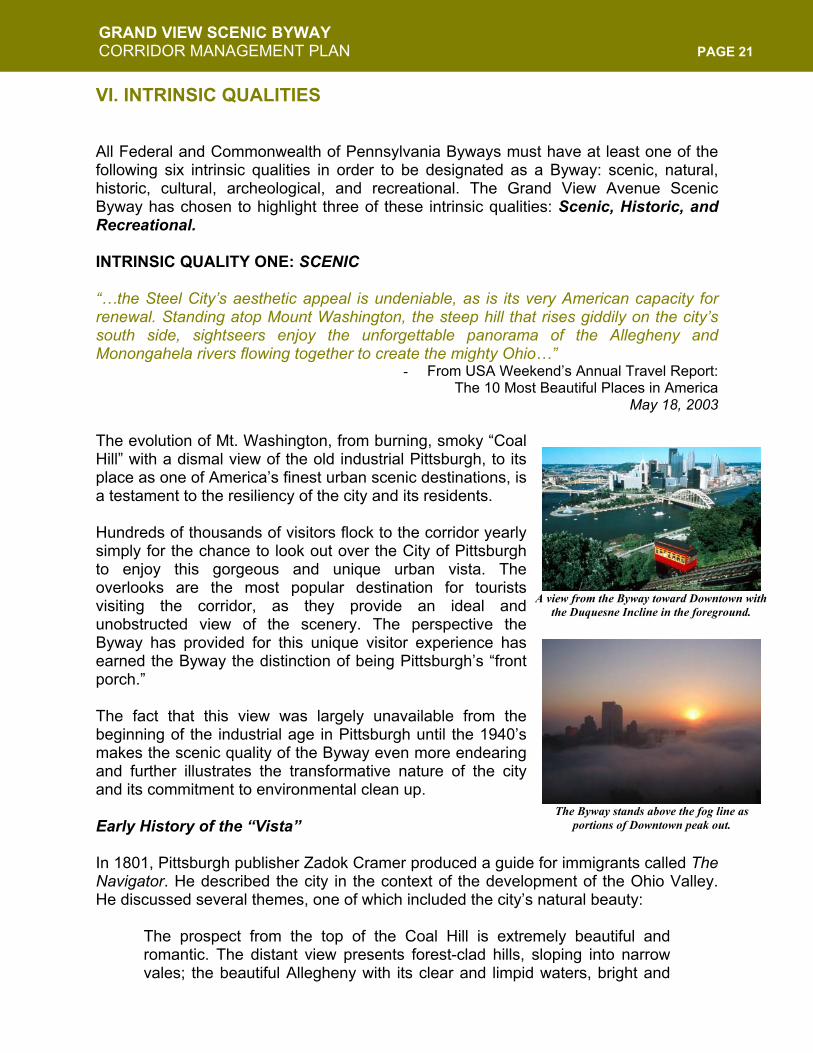
A view from the Byway toward Downtown with
the Duquesne Incline in the foreground.
The Byway stands above the fog line as portions of Downtown peak out.
GRAND VIEW SCENIC BYWAY CORRIDOR MANAGEMENT PLAN PAGE 22
shining, and holding a rapid course compared with that of the Monongahela which, the contrary, seems with its turbid waters to advance lazy and slow, as if to yield involuntary submission…In looking down from Coal Hill into Pittsburgh, one is reminded of Shakespeare’s description of the view from Dover cliff; and seems a giant compared to the busy Lilliputians below…
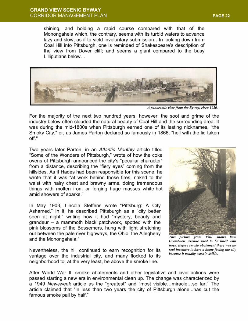
For the majority of the next two hundred years, however, the soot and grime of the industry below often clouded the natural beauty of Coal Hill and the surrounding area. It was during the mid-1800s when Pittsburgh earned one of its lasting nicknames, “the Smoky City," or, as James Parton declared so famously in 1866, "hell with the lid taken off." Two years later Parton, in an Atlantic Monthly article titled “Some of the Wonders of Pittsburgh,” wrote of how the coke ovens of Pittsburgh announced the city’s “peculiar character” from a distance, describing the “fiery eyes” coming from the hillsides. As if Hades had been responsible for this scene, he wrote that it was “at work behind those fires, naked to the waist with hairy chest and brawny arms, doing tremendous things with molten iron, or forging huge masses white-hot amid showers of sparks.” In May 1903, Lincoln Steffens wrote “Pittsburg: A City Ashamed.” In it, he described Pittsburgh as a “city better seen at night,” writing how it had “mystery, beauty and grandeur – a mammoth black patchwork, spotted with the pink blossoms of the Bessemers, hung with light stretching out between the pale river highways, the Ohio, the Allegheny and the Monongahela.” Nevertheless, the hill continued to earn recognition for its vantage over the industrial city, and many flocked to its neighborhood to, at the very least, be above the smoke line. After World War II, smoke abatements and other legislative and civic actions were passed starting a new era in environmental clean up. The change was characterized by a 1949 Newsweek article as the “greatest” and “most visible…miracle…so far.” The article claimed that “in less than two years the city of Pittsburgh alone...has cut the famous smoke pall by half.”
A panoramic view from the Byway, circa 1920.
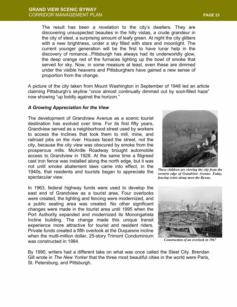
This picture from 1961 shows howGrandview Avenue used to be lined withtrees. Before smoke abatement there was noreal incentive to have a home facing the citybecause it usually wasn’t visible.
GRAND VIEW SCENIC BYWAY CORRIDOR MANAGEMENT PLAN PAGE 23
The result has been a revelation to the city’s dwellers. They are discovering unsuspected beauties in the hilly vistas, a crude grandeur in the city of steel, a surprising amount of leafy green. At night the city glitters with a new brightness, under a sky filled with stars and moonlight. The current younger generation will be the first to have lunar help in the discovery of romance...Pittsburgh has always had its underworldly glow, the deep orange red of the furnaces lighting up the bowl of smoke that served for sky. Now, in some measure at least, even these are dimmed under the visible heavens and Pittsburghers have gained a new sense of proportion from the change.
A picture of the city taken from Mount Washington in September of 1948 led an article claiming Pittsburgh’s skyline “once almost continually dimmed out by soot-filled haze” now showing “up boldly against the horizon.” A Growing Appreciation for the View The development of Grandview Avenue as a scenic tourist destination has evolved over time. For its first fifty years, Grandview served as a neighborhood street used by workers to access the Inclines that took them to mill, mine, and railroad jobs on the river. Houses faced the street, not the city, because the city view was obscured by smoke from the prosperous mills. McArdle Roadway brought automobile access to Grandview in 1928. At the same time a filigreed cast iron fence was installed along the north edge, but it was not until smoke abatement laws came into effect, in the 1940s, that residents and tourists began to appreciate the spectacular view. In 1963, federal highway funds were used to develop the east end of Grandview as a tourist area. Four overlooks were created, the lighting and fencing were modernized, and a public seating area was created. No other significant changes were made in the tourist area until 1995 when the Port Authority expanded and modernized its Monongahela Incline building. The change made this unique transit experience more attractive for tourist and resident riders. Private funds created a fifth overlook at the Duquesne incline when the multi-million dollar, 25-story Trimont Condominium was constructed in 1984. By 1990, writers had a different take on what was once called the Steel City. Brendan Gill wrote in The New Yorker that the three most beautiful cities in the world were Paris, St. Petersburg, and Pittsburgh.
These children are viewing the city from thewestern edge of Grandview Avenue. Today,fencing exists along most the Byway.
Construction of an overlook in 1967
GRAND VIEW SCENIC BYWAY CORRIDOR MANAGEMENT PLAN PAGE 24
The View Today As part three of this section will illustrate, the scenic view from the Byway is one treasured by visitors and residents and lends itself to the many recreational aspects of the corridor. This impressive urban presence has found a balance with the preservation of natural beauty, creating a unique combination of urban architecture and green space. Views of the beautiful rivers, lush green hills, and rolling vistas of the city have returned, along with a shining skyline that demonstrates Pittsburgh’s renewal. Steep slopes and open green space combine with rich natural landscaping, massive rock retaining walls, and unique tunnel façades. Additionally, the view from below, looking up at the Byway, reveals a neighborhood that, itself, is constantly maturing. It is for these reasons USA Weekend named the scenic beauty from the Byway the second best in the country in 2004. Wildlife has also returned to the Byway. Red-tailed hawk, deer, wild turkey, a number of native plant species previously thought not to exist here are once again cohabitating with Byway residents. Traveling up either P.J. McArdle Roadway or E. Sycamore Street slowly introduces visitors to the scenic wonder of the Byway. Each ascent is a winding, tree-lined road, and the view over the slope gives a changing glimpse of Downtown and the scenery below. Upon arriving at the top, either from one the roadways or one of the inclines, visitors are greeted by a vibrant neighborhood full of architectural treasures and the awe-inspiring grand views of the city below. Though the businesses throughout the corridor offer plenty for visitors, the scenery itself has become the true destination. Utilized as a backdrop for photos—including weddings, graduations, proms, and other events—the unique vista also serve as a wonderful prop in the various movies filmed in the city and as an economic engine for restaurants along “Restaurant Row,” who offer not only fine food but also the best views in town. Visitors gazing out across the city can make a series of historical connections between Pittsburgh and U.S. history. Visitors see the remains of Fort Pitt and Fort Duquesne on the Point, as well the launch site for Lewis & Clark’s westward expedition. In Duquesne Heights and Mt. Washington, there were two Civil War forts. And the Byway
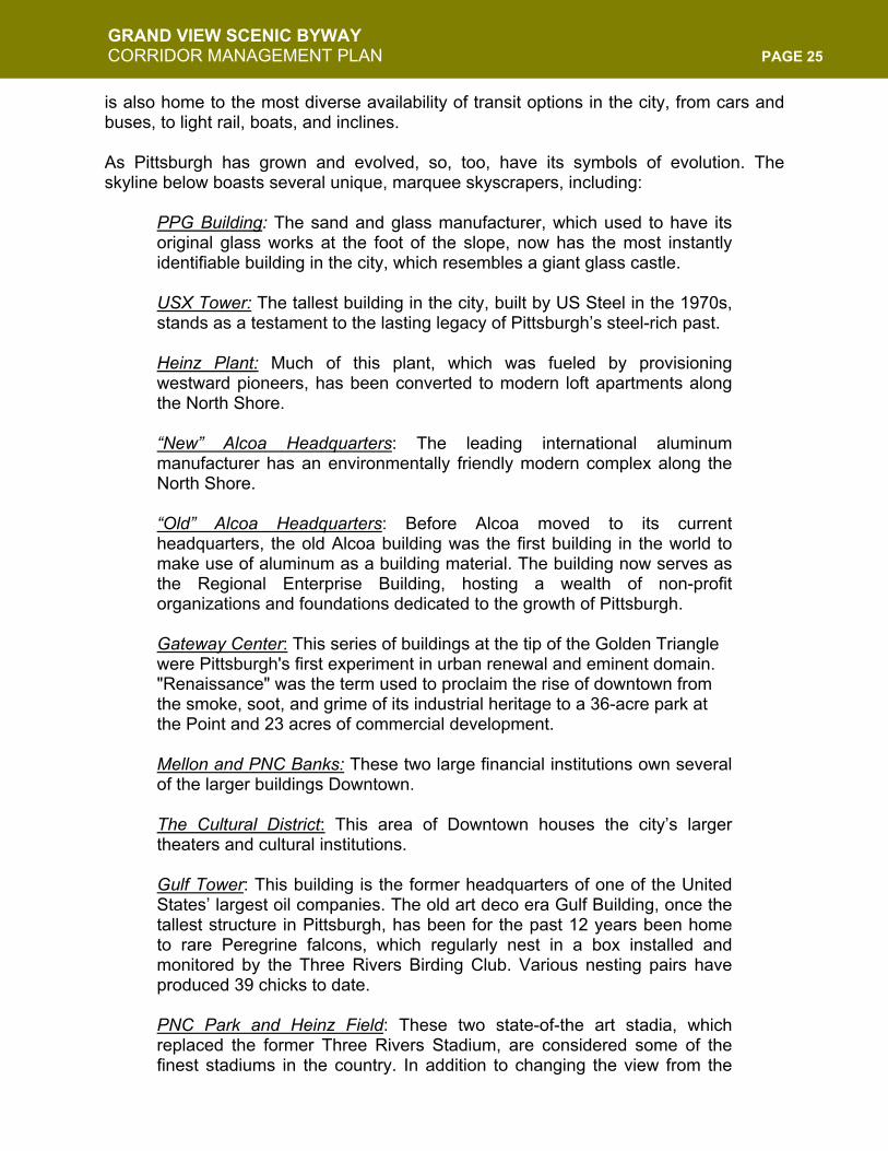
“I remember the day theydemolished Three Rivers Stadium(February 11, 2001). We hostedan open-house breakfast at 6amat the church, and it was such acold morning! We had over 200folks show up, and they were sograteful for the hot cocoa and useof our restrooms. The view of the demolition fromGrandview was spectacular. Idon’t think anyone is going toforget that day.”
- Rev. Bebb Stone
A view from Mount Washington of the
demolition of Three Rivers Stadium
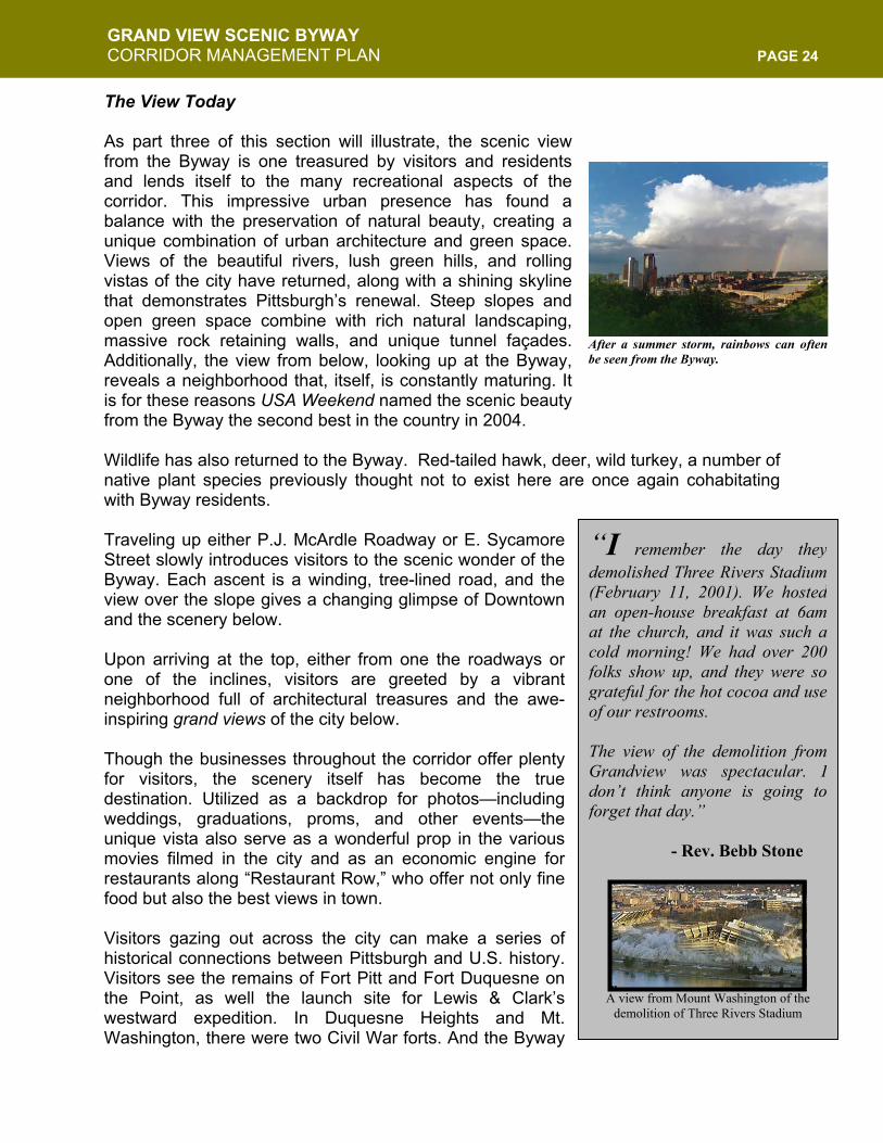
After a summer storm, rainbows can oftenbe seen from the Byway.
GRAND VIEW SCENIC BYWAY CORRIDOR MANAGEMENT PLAN PAGE 25
is also home to the most diverse availability of transit options in the city, from cars and buses, to light rail, boats, and inclines. As Pittsburgh has grown and evolved, so, too, have its symbols of evolution. The skyline below boasts several unique, marquee skyscrapers, including:
PPG Building: The sand and glass manufacturer, which used to have its original glass works at the foot of the slope, now has the most instantly identifiable building in the city, which resembles a giant glass castle. USX Tower: The tallest building in the city, built by US Steel in the 1970s, stands as a testament to the lasting legacy of Pittsburgh’s steel-rich past. Heinz Plant: Much of this plant, which was fueled by provisioning westward pioneers, has been converted to modern loft apartments along the North Shore. “New” Alcoa Headquarters: The leading international aluminum manufacturer has an environmentally friendly modern complex along the North Shore. “Old” Alcoa Headquarters: Before Alcoa moved to its current headquarters, the old Alcoa building was the first building in the world to make use of aluminum as a building material. The building now serves as the Regional Enterprise Building, hosting a wealth of non-profit organizations and foundations dedicated to the growth of Pittsburgh. Gateway Center: This series of buildings at the tip of the Golden Triangle were Pittsburgh's first experiment in urban renewal and eminent domain. "Renaissance" was the term used to proclaim the rise of downtown from the smoke, soot, and grime of its industrial heritage to a 36-acre park at the Point and 23 acres of commercial development. Mellon and PNC Banks: These two large financial institutions own several of the larger buildings Downtown. The Cultural District: This area of Downtown houses the city’s larger theaters and cultural institutions. Gulf Tower: This building is the former headquarters of one of the United States’ largest oil companies. The old art deco era Gulf Building, once the tallest structure in Pittsburgh, has been for the past 12 years been home to rare Peregrine falcons, which regularly nest in a box installed and monitored by the Three Rivers Birding Club. Various nesting pairs have produced 39 chicks to date. PNC Park and Heinz Field: These two state-of-the art stadia, which replaced the former Three Rivers Stadium, are considered some of the finest stadiums in the country. In addition to changing the view from the
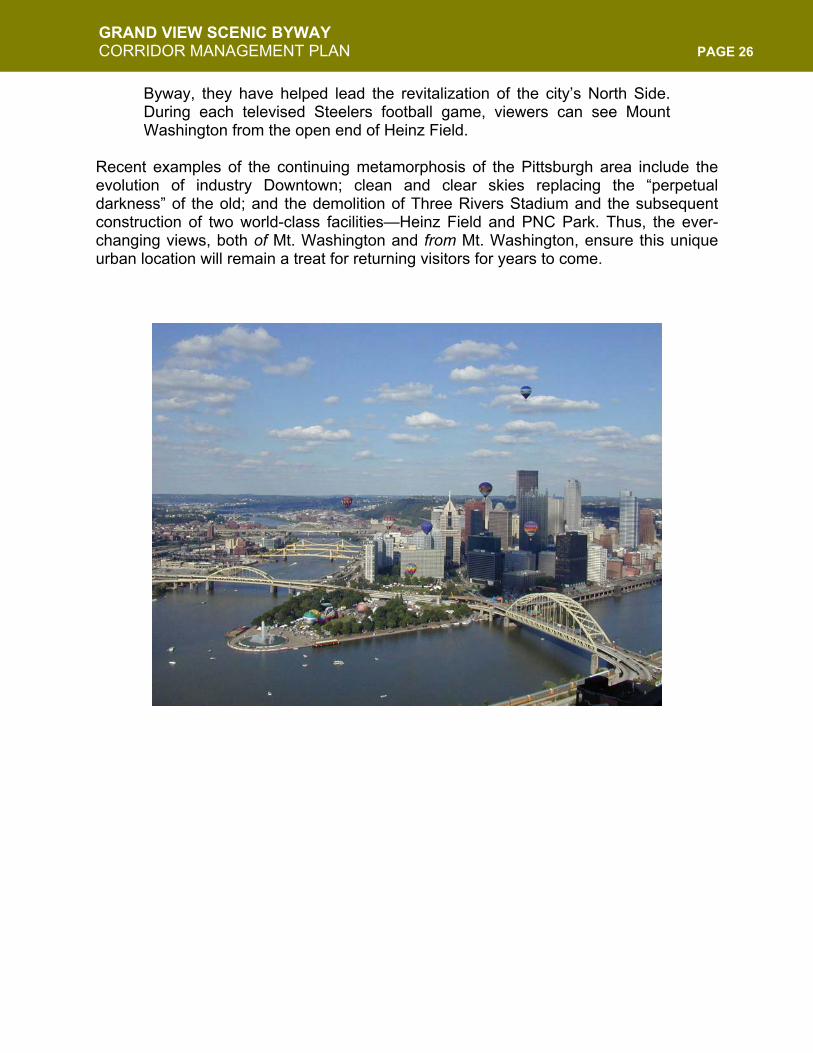
GRAND VIEW SCENIC BYWAY CORRIDOR MANAGEMENT PLAN PAGE 26
Byway, they have helped lead the revitalization of the city’s North Side. During each televised Steelers football game, viewers can see Mount Washington from the open end of Heinz Field.
Recent examples of the continuing metamorphosis of the Pittsburgh area include the evolution of industry Downtown; clean and clear skies replacing the “perpetual darkness” of the old; and the demolition of Three Rivers Stadium and the subsequent construction of two world-class facilities—Heinz Field and PNC Park. Thus, the ever-changing views, both of Mt. Washington and from Mt. Washington, ensure this unique urban location will remain a treat for returning visitors for years to come.
GRAND VIEW SCENIC BYWAY CORRIDOR MANAGEMENT PLAN PAGE 27
INTRINSIC QUALITY TWO: HISTORIC The history of Pittsburgh is the history of America: growing from its role in the westward expansion into the new frontier, the city has constantly reinvented itself. Pittsburgh has evolved from an early trading outpost and fort, to the center of the rise and fall of industrial dominance, to a Renaissance defined by the embrace of change and new technology. From the beginning of this history has stood Mt. Washington, a mighty slope on the edge of the three rivers. More than just another scenic overlook, Mt. Washington, its residents, and its coal were essential to the development of Pittsburgh as an internationally recognized industrial city. Once known as Coal Hill, Mt. Washington and its rich resources from this hill and others like it were almost exclusively responsible for fueling the city’s entrance into industrial dominance. The neighborhood that grew from the hill once known to be perpetually “on fire” has, much like the city it is a part of, become a symbol for perseverance and change. From the dark industrial past has sprung a vibrant neighborhood that has continually reinvented itself, all the while bearing witness to this city’s history. Undoubtedly, as eras pass, much like the boats and ships that have traveled the confluence of the mighty Three Rivers, Pittsburgh and its history will continue to represent American progress and ingenuity. And the good people of Mt. Washington, who occupy the winding streets and slopes of this unique urban environment, will continue to enhance their neighborhood, keeping in step with the changing landscape of the American experience. Early History Indigenous Groups Long before the arrival of white settlers, the area defined by the confluence of the Monongahela and Allegheny Rivers, which come together to form the Ohio River, was territory shared by indigenous people, loosely and collectively known as Eastern Woodlands Indians (Delaware, Shawnee, Iroquois and others). They had an elaborate system of diplomacy and government that early white explorers and traders initially complied with. For native people, most of the surrounding forest was good hunting territory, and they burned or cut away the underbrush beneath the massive deciduous trees to provide for clear sighting of quarry. The prevalence of rock outcroppings along the steep face of Mount Washington suggest to some archaeologists that people may have lived here for perhaps thousands of years before white Europeans arrived. Colloquial references to “Indian Caves” and “Indian steps” are now believed to be references to very real things. These first peoples relied on the three rivers for drink, fishing and transport. Even into the 18th century, the flat, triangular spit of land where the three rivers met was essentially a navigational landmark; it did not hold the same commercial or tactical military significance for indigenous people that Europeans would later attach to it. In the
GRAND VIEW SCENIC BYWAY CORRIDOR MANAGEMENT PLAN PAGE 28
mid-1750s France and England literally went to war over this point of land. That war spelled the beginning of the end of native predominance in North America changed the fortunes of European Empires and begat the American Revolution. The Struggle for Colonial Power Early European explorers saw the advantage of this well-situated flat plain nestled between great rivers and steep hills. First the French claimed it, trading, living and even intermarrying with native populations. But soon, the British began encroaching as their Eastern coastal populations grew. A 19-year-old George Washington, surveying the territory for the Ohio Company, but with a decidedly military eye, described the point as an ideal site for a fort, noting its attractive “command of the two rivers.” As a young Provincial Officer, he relied on a young Seneca named Guyasuta (the Hunter), to guide him up the Allegheny to deliver a request that the French leave the territory. Washington would later survive a winter plunge into the icy Allegheny, and gain both fame and infamy for his interactions in this part of the world. He arguably began the French and Indian War over this land, and that war would forge his character as a leader of men. The area now known as the “Point” or the “Golden Triangle” saw much hostility in that war. Britain originally received permission from area Indians to build a stronghouse at this location, realizing its importance as a trading center. The French razed that structure practically before it was started, and built a fort, called Duquesne. But they themselves burned that structure to the ground rather than let the British conquer it in 1758. In its place, England erected a fortress three times the size of Fort Duquesne and christened it Fort Pitt (after Prime Minister William Pitt), despite treaties with the Indians promising no white settlement in the region. Legend has it that smallpox-infested blankets were handed out from this fort in an effort to eradicate the native populations.
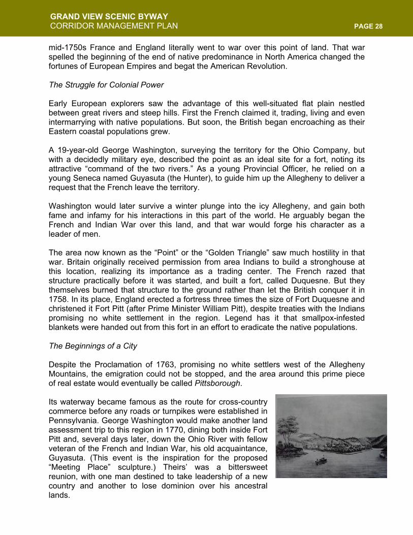
The Beginnings of a City Despite the Proclamation of 1763, promising no white settlers west of the Allegheny Mountains, the emigration could not be stopped, and the area around this prime piece of real estate would eventually be called Pittsborough. Its waterway became famous as the route for cross-country commerce before any roads or turnpikes were established in Pennsylvania. George Washington would make another land assessment trip to this region in 1770, dining both inside Fort Pitt and, several days later, down the Ohio River with fellow veteran of the French and Indian War, his old acquaintance, Guyasuta. (This event is the inspiration for the proposed “Meeting Place” sculpture.) Theirs’ was a bittersweet reunion, with one man destined to take leadership of a new country and another to lose dominion over his ancestral lands.
GRAND VIEW SCENIC BYWAY CORRIDOR MANAGEMENT PLAN PAGE 29
Pittsburgh was destined to be more than just a fort-trading outpost. By the 1790s, defeat of Indian resistance helped spurn greater migration westward. Pittsburgh, with a population of just over 1,000, earned designation as the Allegheny County seat in 1788 and was incorporated as a borough in 1794. The population began to grow as the city gained renown as a center of trade, early industry and travel. Visitors who passed through were undoubtedly impressed with the scenic natural beauty of the area. They also helped to create a constant market for goods. These items, which were more easily produced here rather than risking transport from the East, helped grow the early industrial base of the city.
The Journey of Lewis and Clark
In 1802 President Jefferson began to organize an official, government-sponsored expedition westward. The journey, which would travel up the Missouri River and overland to the Pacific Ocean, was to be led by Meriwether Lewis, Jefferson’s personal secretary. Before being called to serve Jefferson, Lewis was an officer in the military who had been stationed throughout the Pittsburgh area. In 1803, before joining William Clark in Indiana, Lewis departed Elizabeth, Pennsylvania (which is in the Pittsburgh area along the Monongahela River) in his 55-foot keelboat, which was built here. It was from Pittsburgh that he made his journey down the Ohio River and into history.
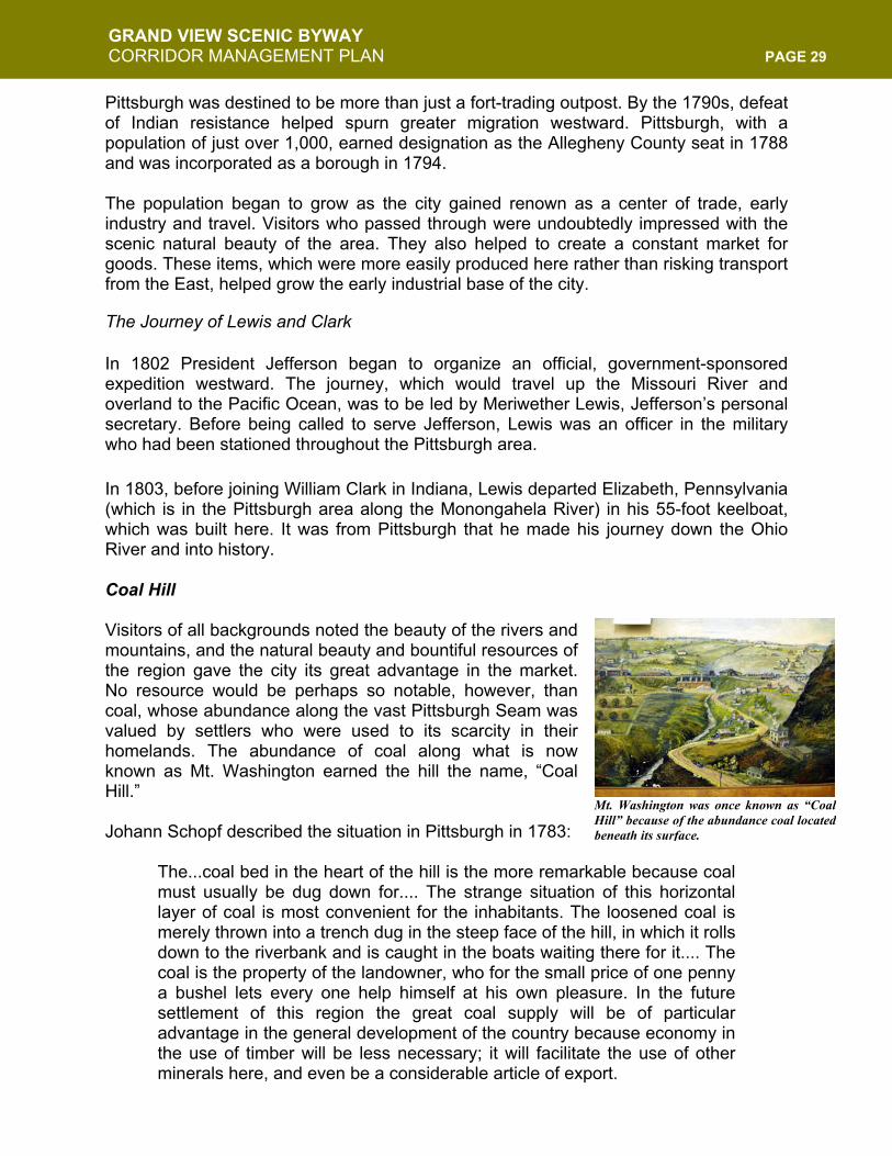
Coal Hill Visitors of all backgrounds noted the beauty of the rivers and mountains, and the natural beauty and bountiful resources of the region gave the city its great advantage in the market. No resource would be perhaps so notable, however, than coal, whose abundance along the vast Pittsburgh Seam was valued by settlers who were used to its scarcity in their homelands. The abundance of coal along what is now known as Mt. Washington earned the hill the name, “Coal Hill.” Johann Schopf described the situation in Pittsburgh in 1783:
The...coal bed in the heart of the hill is the more remarkable because coal must usually be dug down for.... The strange situation of this horizontal layer of coal is most convenient for the inhabitants. The loosened coal is merely thrown into a trench dug in the steep face of the hill, in which it rolls down to the riverbank and is caught in the boats waiting there for it.... The coal is the property of the landowner, who for the small price of one penny a bushel lets every one help himself at his own pleasure. In the future settlement of this region the great coal supply will be of particular advantage in the general development of the country because economy in the use of timber will be less necessary; it will facilitate the use of other minerals here, and even be a considerable article of export.
Mt. Washington was once known as “CoalHill” because of the abundance coal locatedbeneath its surface.
GRAND VIEW SCENIC BYWAY CORRIDOR MANAGEMENT PLAN PAGE 30
Industrial Revolution While rivers, railroads, the abundance of steel, and the talent of the individuals in this city were the driving force and the competitive advantage that helped Pittsburgh later stake its claim as the “Iron City” and the “Steel Capital of the World,” the development of the region’s industrial dominance was intrinsically linked to coal. Mount Washington was originally known as “Coal Hill,” due to the rich strata of coal that lies under it, and throughout the region. In fact, it was the first site of bituminous coal mining in Pennsylvania, beginning in 1762. The layer of coal is exposed in the steep bluff face of the landform that facilitated its discovery and the inception of coal mining in Western Pennsylvania in the early nineteenth century. The coal under Mount Washington was almost completely extracted by the beginning of the twentieth century, leaving only widely spaced columns of coal to support the earth-form and the developing neighborhood above it. As the historic marker on Grandview Avenue points out, the Pittsburgh Seam has proven to be the most commercially valuable mineral deposit in North America. Certainly its exploitation has been partially responsible for the development of Pittsburgh as an industrial and financial center of the nineteenth century, and as the major metropolis we know today. A great fire in the coal seams, which started in the early 1760s, burned on for decades. While preaching in Pittsburgh in 1766, Reverend Charles Beatty described the underground fire:
A fire being made [on the hill] by the workmen not far from the place where they dug the coal, and left burning when they went away, by the small dust communicated itself to the body of the coals and set it on fire, and has now been burning almost a twelve month entirely under ground, for the space of twenty yards or more along the face of the hill or rock, the way the vein of coal extends, the smoke ascending up through the chinks of the rocks, The earth in some places is so warm, that we could hardly bear to stand upon it; as one place where the smoke came up we opened a hole in the earth till it was so hot as to burn paper thrown into it; the steam that came out was so strong of sulphur that we could scarce bare it. We found pieces of matter there, some of which appeared to be sulphur, others nitre, and some a mixture of both...
The fire continued to burn for many years. In the 1826 Pittsburgh City Directory substantiated this claim:
In that part of the hill above the Pittsburgh Glass-works...there has been fire burning for many years, and the smoke may be seen daily curling from out the fissures of the rocks. The fire is in the midst of the great strata of
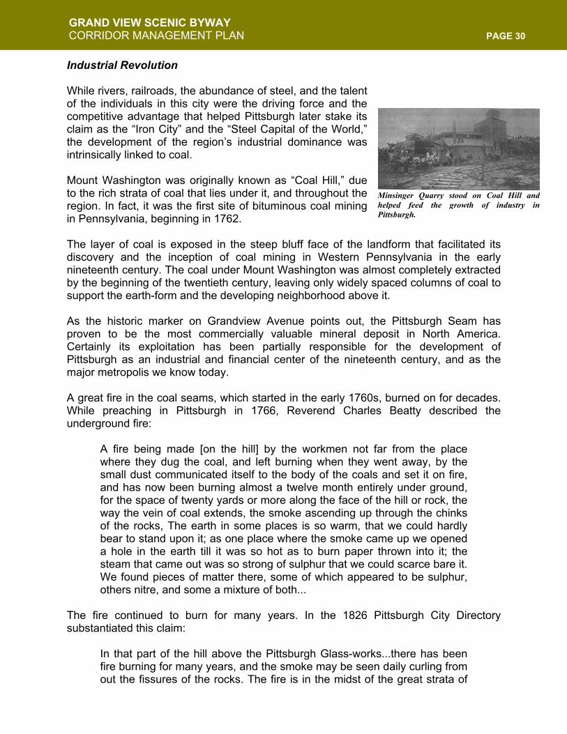
Minsinger Quarry stood on Coal Hill andhelped feed the growth of industry inPittsburgh.
GRAND VIEW SCENIC BYWAY CORRIDOR MANAGEMENT PLAN PAGE 31
coal that here stretches along the hill.... Frequent attempts have been made to suppress the burning, by stopping up the mouth of the mine and neighboring crevices...but in vain it still rages, and is daily extending, and may some day produce serious consequences.
The value of the large deposits of the region’s coal—which were close to the surface, plentiful, and highly inexpensive—were made even more important because of the river transportation network at the bottom of the hills. The industrial potential created with this situation was made even better through the presence other mineral resources useful for iron and glass making: sand, limestone, and iron ore. As settlers continued to push westward, Pittsburgh, for a while, was seen by many as the furthest point West in America, still untamed and full of the hope and possibility that only the west could afford. Combined with the industrial growth of the region and the abundance of raw materials, Pittsburgh embarked on a period of immense growth. The coal of Mt. Washington helped heat the furnaces that would lead to glass and iron production. When the city was chartered as a city in 1816, iron production was already the biggest industry. By this period, Pittsburgh had gained its nickname, the “Iron City.” The dominance of the iron industry in Pittsburgh was joined by the successes of several other major industries, including materials and goods for those traveling west and the materials needed for waging war. The War of 1812 created a boom for the city, as the Ohio and the Mississippi provided the main water route north and south after the coastal sea route was cut off. More commerce went through Pittsburgh during the war than ever before. The military industry has always fueled the business of Pittsburgh’s mills and factories, which was a natural growth as wars were of economic significance since the French and Indian War. Pittsburgh’s growth from a population of 2,400 in 1800 to an estimated 9,000 in 1815 was directly attributed to the War of 1812, according to the Pittsburgh Directory for 1815. In 1855, Henry Bessemer took out a patent for his process of rendering cast iron malleable by the introduction of air into the fluid metal to remove carbon. Bessemer's process was a method to refine iron into steel, and it quickly caught on in the Iron City. This helped further the industrialization and improvements in the iron making process and lead to the growth of the steel industry. The growth of the steel industry was crucial to westward expansion and improvements to the industrial process. The success of the railroad industry was directly tied to the stronger material of steel and Pittsburgh served as the center of the railroad industry. The Civil War brought a need for increased steel production and, yet again, more war profits were created. During the Civil War, several forts were built on Mount Washington and
coke – A solid carbonaceous residue derived from low-ash, low-sulfur bituminous coal from which the volatile constituents are driven off by baking in an oven at temperatures as high as 2,000 degrees Fahrenheit so that the fixed carbon and residual ash are fused together. Coke is used as a fuel and as a reducing agent in smelting iron ore in a blast furnace. Coke from coal is grey, hard, and porous and has a heating value of 24.8 million Btu per short ton. (From the US Geological Survey)
GRAND VIEW SCENIC BYWAY CORRIDOR MANAGEMENT PLAN PAGE 32
Duquesne Heights, along with another at a high point in the West End. One fort sat above either end of Fingal Street in Mount Washington, just one block from the Byway. Another was in the block now bounded by Oneida, Virginia, Meridan and Sycamore. As the city moved into the later part of the century, fortunes were made and empires built with Pittsburgh steel. Barons like Andrew Carnegie, who owned most of the coal, steel, and railroad interests in the country, built plants and employed the workforces of Pittsburgh. Industry flourished into the next century, until foreign steel and other industrial materials began to compete with American made steel and goods. By the early 1990s, no steel mills existed in Pittsburgh, but the legacy that was left by those boom times have helped build the city. The fortunes of Carnegie, the Heinz and Mellon families, and others have contributed greatly to the cultural growth of the city and their foundations have been the cornerstones of community development in Pittsburgh. Growth and Environmental Clean Up By 1813, coke was being produced in Pittsburgh and by 1833 there was a row of coke ovens at the base of Coal Hill along the Monongahela River, along with five on Sycamore Street. The smoke and soot of the times were signs of Pittsburgh’s industrial prowess, but presented significant public health environmental concerns Smoke from burning coal and the coke ovens became such a significant issue in the city that in 1849, City Council proposed prohibiting further construction of coke ovens and brick kilns within Pittsburgh’s city limits. Smoke abatement ordinance, however, wasn’t actually introduced until 1892. The coke oven ordinance was presented by John Paul, who represented Mount Washington’s 32nd Ward. The bill was passed unanimously by twenty-four members of the Select Council in attendance and sent on to Common Council. In 1846 the Pittsburgh Chronicle ran a brief article lamenting the degraded environmental condition of Coal Hill.
Coal mines, stone quarries and railroads have sadly marred the beauties of this noble barrier to our view towards the West. In the days of its glory, which covered with trees from summit down to the edge of the water, it was the fairest portion of our surrounding scenery. But, now how changed! At its base vast furnaces belch forth dense clouds of flame and smoke, its steep side has been cut down by large quarries, and all along near its top a dozen yawning throats pour down a dozen railroads its rich treasures. Tree and shrub have been reft from their fast hold, and the old hill now stands before us with scarred sides and almost shaven crown.
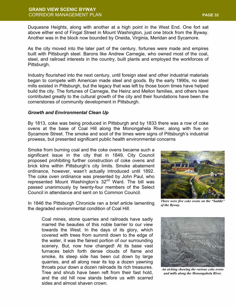
There were five coke ovens on the “Saddle”of the Byway.
An etching showing the various coke ovens and mills along the Monongahela River.
GRAND VIEW SCENIC BYWAY CORRIDOR MANAGEMENT PLAN PAGE 33
We love that hill, and when ever we turn our gaze upon it a thousand pleasing recollections flit across the memory. Our foot has pressed a hundred times upon almost every inch of its summit. Every knoll from which the eye can gaze upon the scenery below, and every grove and clump of trees with their cool shade, has its pleasing associations, and we feel half sad to see the old hill bereft of its glory. But this is a matter of fact world and we live in a money-getting, money-loving generation and the beautiful must give place to the useful.
In September 1948, Business Week was among the first to claim that Pittsburgh’s new anti-smoke efforts were succeeding. It claimed that Pittsburgh’s skyline “once almost continually dimmed out by soot-filled haze” now “show[ed] up boldly against the horizon.” It illustrated this with a picture of the city taken from Mount Washington. Pittsburgh looked to a greater availability of smokeless fuels to keep skies clear through the winter heating season. A month later, in October 1948, American City’s “Our Municipal Notebook” section actually published a poem about Pittsburgh’s cleanup, which had been inspired by a Wall Street Journal Report: “Pittsburgh’s victory over smoke inspires 200 other communities.” The doggerel began:
The streets of Pittsburgh now are clean, The grass of Pittsburgh now is green, The sky of Pittsburgh now is blue, At night, the Pittsburgh moon winks through; Gone is the smog that made unpretty The town yclept “The Smoky City.”
The poem listed
Communities both near and far – From L. A. (Cal.) To Zanzibar, From Gary, Boston and New York To Halifax and County Cork
On October 3, 1949 “Pittsburgh’s Richard Mellon” was on the cover of Time. The article “Mr. Mellon’s Patch” portrayed Pittsburgh as a “city of new hope.” The article celebrated “an industrial development” that was unequaled anywhere in the world.
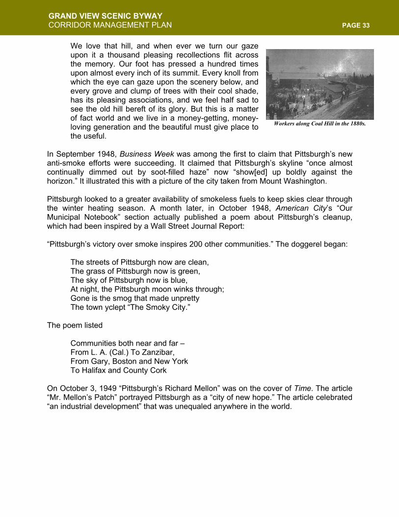
Workers along Coal Hill in the 1880s.
GRAND VIEW SCENIC BYWAY CORRIDOR MANAGEMENT PLAN PAGE 34
The Evolution from Coal Hill to a Neighborhood While long a coal-mining hill, Coal Hill was largely vacant to residents with the exception of miners. Initially, German immigrants settled in the areas, followed by a wave of Irish and English, then later Italians, Polish, and other mostly Eastern European immigrants. Remnants of these ethnic groups are still here today. At this time, public transit was practically nonexistent. People needed to live within walking distance of their place of employment. While industry occupied most flat lands near the rivers, only the steep, surrounding hillsides provided land for housing. “Indian Steps,” a one-mile long switchback of steps ran the entire front of Mount’s cliff from Duquesne Heights to where Station Square is today. It was a principal route to and from the mount in pre-incline days, but fell into disuse by 1937. The topography of Pittsburgh was then, and continues to be, a great challenge for moving people and goods. Before tunnels were carved through the giant hillsides, inclines were constructed to transport people, horse carriages and cars up the steep slope. The post-Civil War construction (1867 to 1877) of four inclines included the Monongahela Incline (1870) and Duquesne Incline (1877), which still operate today. The creation of the inclines was due to the technical and engineering skills of the German immigrants who resided on the hill. They became weary of climbing steep footpaths and steps to their homes from the river valley after work, and were reminded of the “steilbahn”s (steel roads), which similar to inclines in Germany. The inclines’ development eased the journey up the face of Mount Washington and allowed the development of the residential neighborhoods at the top of the bluff. In the 25 years following the opening of the Monongahela Incline, on May 28, 1870, at least 17 of these inclined planes were built in the Pittsburgh area; and as the city grew and expanded over the hills that almost surround it, inclines enjoyed great popularity and steady patronage. Speaking of The Duquesne Incline in the autumn of 1880, Scientific American magazine noted, "On Sundays during the summer, 6,000 passengers are carried during the day and evening, the cars ascending and descending as rapidly as filled and emptied."
Residents who couldn’t afford the fare ofthe inclines used these “Indian Steps,”which traveled along the slope of the hilldown to the Monongahela River. Thebuilding of roads made these steps virtuallyobsolete by the 1930s.
An early view of the “Mon” Incline.
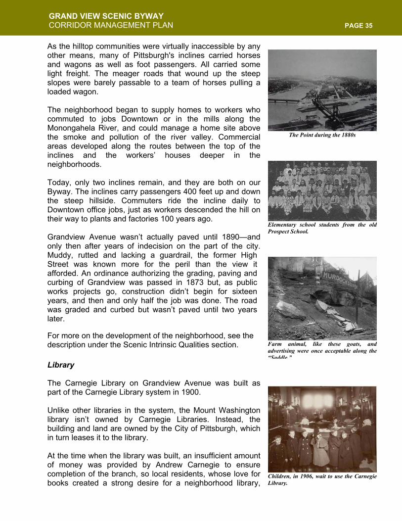
GRAND VIEW SCENIC BYWAY CORRIDOR MANAGEMENT PLAN PAGE 35
As the hilltop communities were virtually inaccessible by any other means, many of Pittsburgh's inclines carried horses and wagons as well as foot passengers. All carried some light freight. The meager roads that wound up the steep slopes were barely passable to a team of horses pulling a loaded wagon. The neighborhood began to supply homes to workers who commuted to jobs Downtown or in the mills along the Monongahela River, and could manage a home site above the smoke and pollution of the river valley. Commercial areas developed along the routes between the top of the inclines and the workers’ houses deeper in the neighborhoods. Today, only two inclines remain, and they are both on our Byway. The inclines carry passengers 400 feet up and down the steep hillside. Commuters ride the incline daily to Downtown office jobs, just as workers descended the hill on their way to plants and factories 100 years ago. Grandview Avenue wasn’t actually paved until 1890—and only then after years of indecision on the part of the city. Muddy, rutted and lacking a guardrail, the former High Street was known more for the peril than the view it afforded. An ordinance authorizing the grading, paving and curbing of Grandview was passed in 1873 but, as public works projects go, construction didn’t begin for sixteen years, and then and only half the job was done. The road was graded and curbed but wasn’t paved until two years later.
For more on the development of the neighborhood, see the description under the Scenic Intrinsic Qualities section. Library The Carnegie Library on Grandview Avenue was built as part of the Carnegie Library system in 1900. Unlike other libraries in the system, the Mount Washington library isn’t owned by Carnegie Libraries. Instead, the building and land are owned by the City of Pittsburgh, which in turn leases it to the library. At the time when the library was built, an insufficient amount of money was provided by Andrew Carnegie to ensure completion of the branch, so local residents, whose love for books created a strong desire for a neighborhood library,
The Point during the 1880s
Elementary school students from the oldProspect School.
Farm animal, like these goats, andadvertising were once acceptable along the“Saddle.”
Children, in 1906, wait to use the CarnegieLibrary.
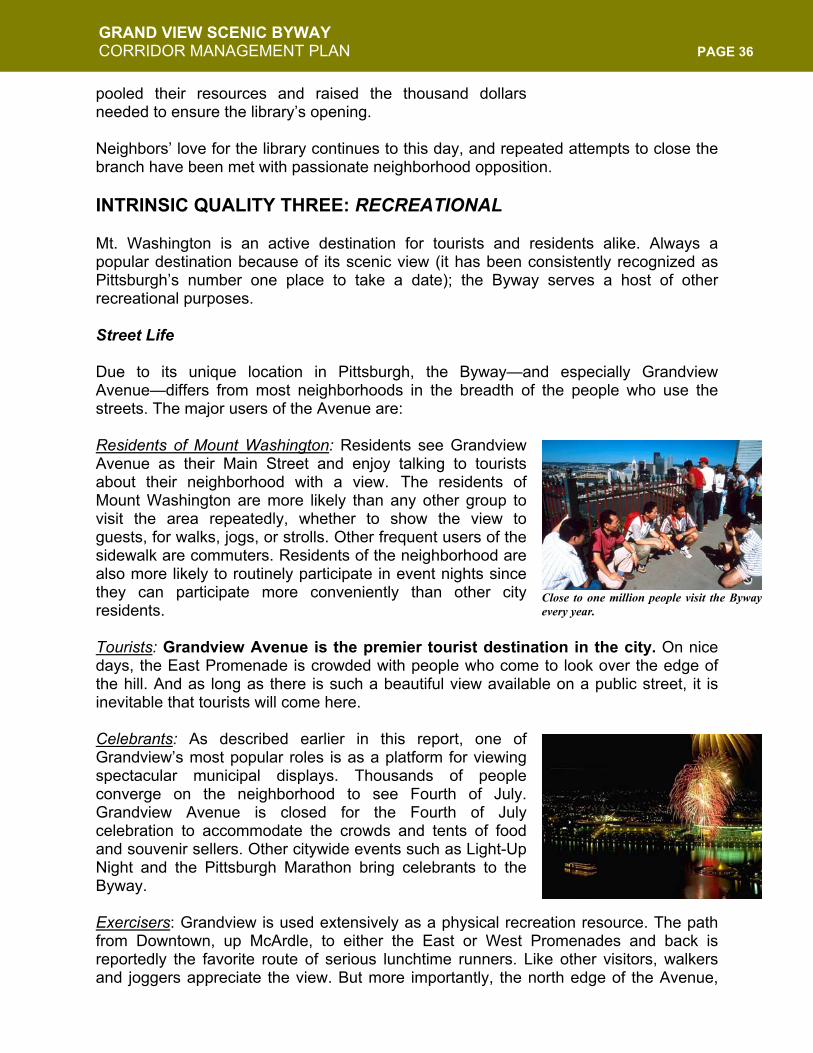
GRAND VIEW SCENIC BYWAY CORRIDOR MANAGEMENT PLAN PAGE 36
pooled their resources and raised the thousand dollars needed to ensure the library’s opening. Neighbors’ love for the library continues to this day, and repeated attempts to close the branch have been met with passionate neighborhood opposition. INTRINSIC QUALITY THREE: RECREATIONAL Mt. Washington is an active destination for tourists and residents alike. Always a popular destination because of its scenic view (it has been consistently recognized as Pittsburgh’s number one place to take a date); the Byway serves a host of other recreational purposes. Street Life Due to its unique location in Pittsburgh, the Byway—and especially Grandview Avenue—differs from most neighborhoods in the breadth of the people who use the streets. The major users of the Avenue are: Residents of Mount Washington: Residents see Grandview Avenue as their Main Street and enjoy talking to tourists about their neighborhood with a view. The residents of Mount Washington are more likely than any other group to visit the area repeatedly, whether to show the view to guests, for walks, jogs, or strolls. Other frequent users of the sidewalk are commuters. Residents of the neighborhood are also more likely to routinely participate in event nights since they can participate more conveniently than other city residents. Tourists: Grandview Avenue is the premier tourist destination in the city. On nice days, the East Promenade is crowded with people who come to look over the edge of the hill. And as long as there is such a beautiful view available on a public street, it is inevitable that tourists will come here. Celebrants: As described earlier in this report, one of Grandview’s most popular roles is as a platform for viewing spectacular municipal displays. Thousands of people converge on the neighborhood to see Fourth of July. Grandview Avenue is closed for the Fourth of July celebration to accommodate the crowds and tents of food and souvenir sellers. Other citywide events such as Light-Up Night and the Pittsburgh Marathon bring celebrants to the Byway. Exercisers: Grandview is used extensively as a physical recreation resource. The path from Downtown, up McArdle, to either the East or West Promenades and back is reportedly the favorite route of serious lunchtime runners. Like other visitors, walkers and joggers appreciate the view. But more importantly, the north edge of the Avenue,
Close to one million people visit the Bywayevery year.
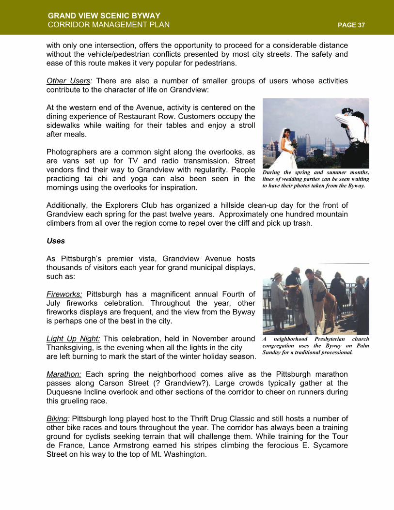
GRAND VIEW SCENIC BYWAY CORRIDOR MANAGEMENT PLAN PAGE 37
with only one intersection, offers the opportunity to proceed for a considerable distance without the vehicle/pedestrian conflicts presented by most city streets. The safety and ease of this route makes it very popular for pedestrians. Other Users: There are also a number of smaller groups of users whose activities contribute to the character of life on Grandview: At the western end of the Avenue, activity is centered on the dining experience of Restaurant Row. Customers occupy the sidewalks while waiting for their tables and enjoy a stroll after meals. Photographers are a common sight along the overlooks, as are vans set up for TV and radio transmission. Street vendors find their way to Grandview with regularity. People practicing tai chi and yoga can also been seen in the mornings using the overlooks for inspiration. Additionally, the Explorers Club has organized a hillside clean-up day for the front of Grandview each spring for the past twelve years. Approximately one hundred mountain climbers from all over the region come to repel over the cliff and pick up trash. Uses As Pittsburgh’s premier vista, Grandview Avenue hosts thousands of visitors each year for grand municipal displays, such as: Fireworks: Pittsburgh has a magnificent annual Fourth of July fireworks celebration. Throughout the year, other fireworks displays are frequent, and the view from the Byway is perhaps one of the best in the city. Light Up Night: This celebration, held in November around Thanksgiving, is the evening when all the lights in the city are left burning to mark the start of the winter holiday season. Marathon: Each spring the neighborhood comes alive as the Pittsburgh marathon passes along Carson Street (? Grandview?). Large crowds typically gather at the Duquesne Incline overlook and other sections of the corridor to cheer on runners during this grueling race. Biking: Pittsburgh long played host to the Thrift Drug Classic and still hosts a number of other bike races and tours throughout the year. The corridor has always been a training ground for cyclists seeking terrain that will challenge them. While training for the Tour de France, Lance Armstrong earned his stripes climbing the ferocious E. Sycamore Street on his way to the top of Mt. Washington.
During the spring and summer months,lines of wedding parties can be seen waitingto have their photos taken from the Byway.
A neighborhood Presbyterian churchcongregation uses the Byway on PalmSunday for a traditional processional.
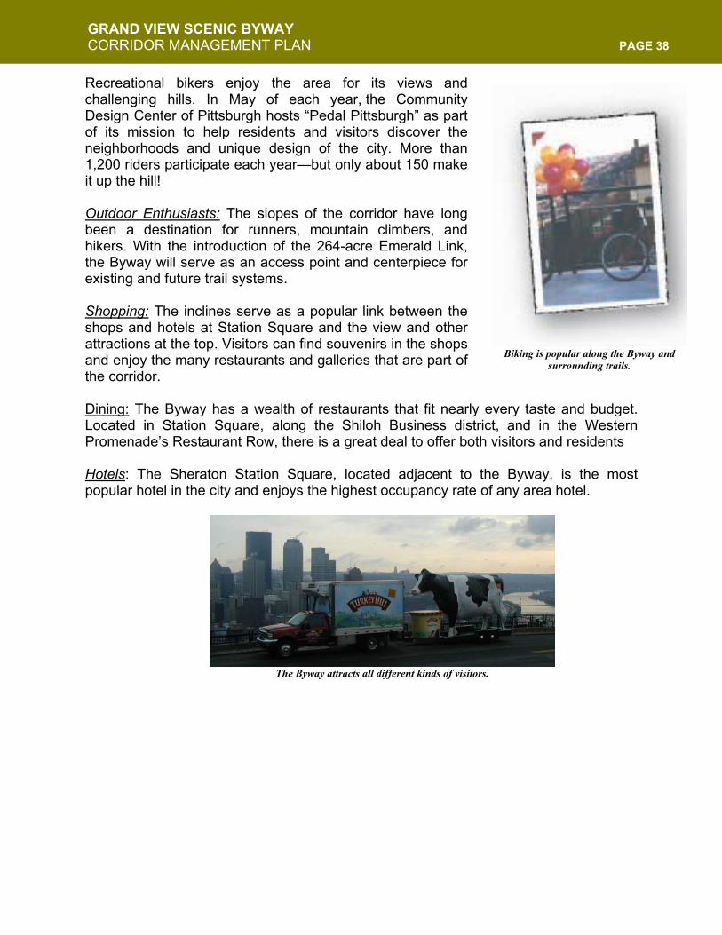
GRAND VIEW SCENIC BYWAY CORRIDOR MANAGEMENT PLAN PAGE 38
Recreational bikers enjoy the area for its views and challenging hills. In May of each year, the Community Design Center of Pittsburgh hosts “Pedal Pittsburgh” as part of its mission to help residents and visitors discover the neighborhoods and unique design of the city. More than 1,200 riders participate each year—but only about 150 make it up the hill! Outdoor Enthusiasts: The slopes of the corridor have long been a destination for runners, mountain climbers, and hikers. With the introduction of the 264-acre Emerald Link, the Byway will serve as an access point and centerpiece for existing and future trail systems.
Shopping: The inclines serve as a popular link between the shops and hotels at Station Square and the view and other attractions at the top. Visitors can find souvenirs in the shops and enjoy the many restaurants and galleries that are part of the corridor. Dining: The Byway has a wealth of restaurants that fit nearly every taste and budget. Located in Station Square, along the Shiloh Business district, and in the Western Promenade’s Restaurant Row, there is a great deal to offer both visitors and residents Hotels: The Sheraton Station Square, located adjacent to the Byway, is the most popular hotel in the city and enjoys the highest occupancy rate of any area hotel.
Biking is popular along the Byway and surrounding trails.
The Byway attracts all different kinds of visitors.
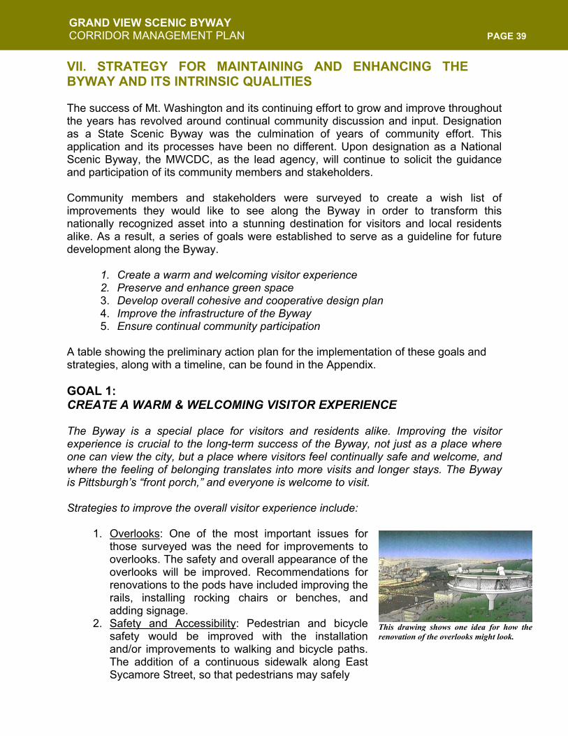
GRAND VIEW SCENIC BYWAY CORRIDOR MANAGEMENT PLAN PAGE 39
VII. STRATEGY FOR MAINTAINING AND ENHANCING THE BYWAY AND ITS INTRINSIC QUALITIES The success of Mt. Washington and its continuing effort to grow and improve throughout the years has revolved around continual community discussion and input. Designation as a State Scenic Byway was the culmination of years of community effort. This application and its processes have been no different. Upon designation as a National Scenic Byway, the MWCDC, as the lead agency, will continue to solicit the guidance and participation of its community members and stakeholders. Community members and stakeholders were surveyed to create a wish list of improvements they would like to see along the Byway in order to transform this nationally recognized asset into a stunning destination for visitors and local residents alike. As a result, a series of goals were established to serve as a guideline for future development along the Byway.
1. Create a warm and welcoming visitor experience 2. Preserve and enhance green space 3. Develop overall cohesive and cooperative design plan 4. Improve the infrastructure of the Byway 5. Ensure continual community participation
A table showing the preliminary action plan for the implementation of these goals and strategies, along with a timeline, can be found in the Appendix. GOAL 1: CREATE A WARM & WELCOMING VISITOR EXPERIENCE The Byway is a special place for visitors and residents alike. Improving the visitor experience is crucial to the long-term success of the Byway, not just as a place where one can view the city, but a place where visitors feel continually safe and welcome, and where the feeling of belonging translates into more visits and longer stays. The Byway is Pittsburgh’s “front porch,” and everyone is welcome to visit. Strategies to improve the overall visitor experience include:
1. Overlooks: One of the most important issues for those surveyed was the need for improvements to overlooks. The safety and overall appearance of the overlooks will be improved. Recommendations for renovations to the pods have included improving the rails, installing rocking chairs or benches, and adding signage.
2. Safety and Accessibility: Pedestrian and bicycle safety would be improved with the installation and/or improvements to walking and bicycle paths. The addition of a continuous sidewalk along East Sycamore Street, so that pedestrians may safely
This drawing shows one idea for how therenovation of the overlooks might look.
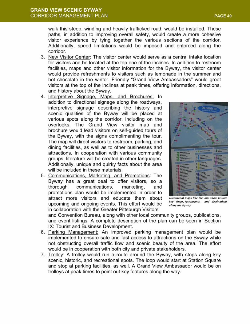
GRAND VIEW SCENIC BYWAY CORRIDOR MANAGEMENT PLAN PAGE 40
walk this steep, winding and heavily trafficked road, would be installed. These paths, in addition to improving overall safety, would create a more cohesive visitor experience by tying together the various sections of the corridor. Additionally, speed limitations would be imposed and enforced along the corridor.
3. New Visitor Center: The visitor center would serve as a central intake location for visitors and be located at the top one of the inclines. In addition to restroom facilities, maps and other visitor information for the Byway, the visitor center would provide refreshments to visitors such as lemonade in the summer and hot chocolate in the winter. Friendly “Grand View Ambassadors” would greet visitors at the top of the inclines at peak times, offering information, directions, and history about the Byway.
4. Interpretive Signage, Maps, and Brochures: In addition to directional signage along the roadways, interpretive signage describing the history and scenic qualities of the Byway will be placed at various spots along the corridor, including on the overlooks. The Grand View visitor map and brochure would lead visitors on self-guided tours of the Byway, with the signs complimenting the tour. The map will direct visitors to restroom, parking, and dining facilities, as well as to other businesses and attractions. In cooperation with various community groups, literature will be created in other languages. Additionally, unique and quirky facts about the area will be included in these materials.
5. Communications, Marketing, and Promotions: The Byway has a great deal to offer visitors, so a thorough communications, marketing, and promotions plan would be implemented in order to attract more visitors and educate them about upcoming and ongoing events. This effort would be in collaboration with the Greater Pittsburgh Visitors and Convention Bureau, along with other local community groups, publications, and event listings. A complete description of the plan can be seen in Section IX: Tourist and Business Development.
6. Parking Management: An improved parking management plan would be implemented to ensure safe and fast access to attractions on the Byway while not obstructing overall traffic flow and scenic beauty of the area. The effort would be in cooperation with both city and private stakeholders.
7. Trolley: A trolley would run a route around the Byway, with stops along key scenic, historic, and recreational spots. The loop would start at Station Square and stop at parking facilities, as well. A Grand View Ambassador would be on trolleys at peak times to point out key features along the way.
Directional maps like this one show visitors key shops, restaurants, and destinations along the Byway.
GRAND VIEW SCENIC BYWAY CORRIDOR MANAGEMENT PLAN PAGE 41
GOAL 2: PRESERVE AND ENHANCE GREEN SPACE With the development of the Emerald Link plan, the community has already shown its commitment to preserving and enhancing the Byway’s green spaces. The specific goal here is to create an effective connection between the Byway and the Emerald Link while focusing on preservation of the green space specific to the Byway corridor. Attention will be given to the “small touches” that make the Byway experience so enjoyable. The complete Emerald Link scope document can be found in the Appendix. Strategies to preserve and enhance green space include:
1. Balance: MWCDC would work with developers, property owners and groups using the Byway to find ways to maintain a balance between development and scenic open space of the corridor.
2. View: Ensure “view-conscious” planting and sustainable maintenance of hillsides so that views and green spaces are managed in harmony.
3. Hillside Preservation: Working with various conservation groups, the city, and residents, MWCDC would reclaim the hillside (including McArdle Roadway hillside) from neglect and promote native four-season plantings while preserving hillsides as green, natural spaces.
4. Ecological Studies: Environmental consultants and landscapers would be brought on to investigate ecological issues with regard to plant species (native vs. invasive), erosion, and pollution, and offer suggestions for future management.
5. Parklets: Efforts to use open spaces in the neighborhood for miniature parks, such as the one that is part of the Shiloh Street entrance, would continue. Keeping true to ecological responsibility, only native and non-invasive plants would be planted.
6. Private Properties: MWCDC would work with the owners of private properties along the Byway to identify and develop conservation strategies that promote the cohesive and cooperative design and ecological balance of the corridor.
GOAL 3: DEVELOP OVERALL COHESIVE AND COOPERATIVE DESIGN PLAN The Grandview Public Realm zoning ordinance approved in 1998 created a strong starting point for ensuring the positive and responsible development of the Byway by shaping development and zoning requirements along Grandview Avenue. Developing an overall cohesive and cooperative design strategy has been seen as another way to ensure greater continuity among the public sections of the Byway. MWCDC, as steward of the Byway, will work with property owners and the city to create and implement design guidelines that will ultimately improve the appeal of the Byway and illustrate to visitors the Byway’s boundaries.
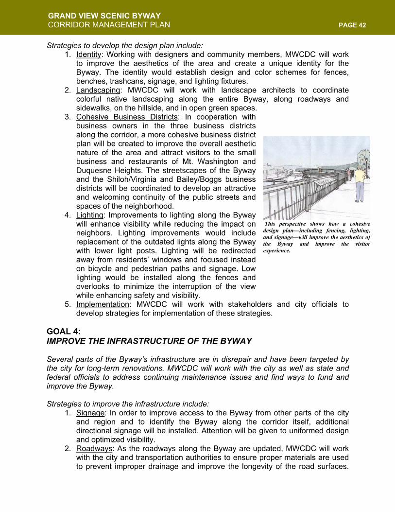
GRAND VIEW SCENIC BYWAY CORRIDOR MANAGEMENT PLAN PAGE 42
Strategies to develop the design plan include: 1. Identity: Working with designers and community members, MWCDC will work
to improve the aesthetics of the area and create a unique identity for the Byway. The identity would establish design and color schemes for fences, benches, trashcans, signage, and lighting fixtures.
2. Landscaping: MWCDC will work with landscape architects to coordinate colorful native landscaping along the entire Byway, along roadways and sidewalks, on the hillside, and in open green spaces.
3. Cohesive Business Districts: In cooperation with business owners in the three business districts along the corridor, a more cohesive business district plan will be created to improve the overall aesthetic nature of the area and attract visitors to the small business and restaurants of Mt. Washington and Duquesne Heights. The streetscapes of the Byway and the Shiloh/Virginia and Bailey/Boggs business districts will be coordinated to develop an attractive and welcoming continuity of the public streets and spaces of the neighborhood.
4. Lighting: Improvements to lighting along the Byway will enhance visibility while reducing the impact on neighbors. Lighting improvements would include replacement of the outdated lights along the Byway with lower light posts. Lighting will be redirected away from residents’ windows and focused instead on bicycle and pedestrian paths and signage. Low lighting would be installed along the fences and overlooks to minimize the interruption of the view while enhancing safety and visibility.
5. Implementation: MWCDC will work with stakeholders and city officials to develop strategies for implementation of these strategies.
GOAL 4: IMPROVE THE INFRASTRUCTURE OF THE BYWAY Several parts of the Byway’s infrastructure are in disrepair and have been targeted by the city for long-term renovations. MWCDC will work with the city as well as state and federal officials to address continuing maintenance issues and find ways to fund and improve the Byway. Strategies to improve the infrastructure include:
1. Signage: In order to improve access to the Byway from other parts of the city and region and to identify the Byway along the corridor itself, additional directional signage will be installed. Attention will be given to uniformed design and optimized visibility.
2. Roadways: As the roadways along the Byway are updated, MWCDC will work with the city and transportation authorities to ensure proper materials are used to prevent improper drainage and improve the longevity of the road surfaces.
This perspective shows how a cohesivedesign plan—including fencing, lighting,and signage—will improve the aesthetics ofthe Byway and improve the visitorexperience.
GRAND VIEW SCENIC BYWAY CORRIDOR MANAGEMENT PLAN PAGE 43
For example, cement rather than macadam would be used along Grandview in future resurfacing.
3. Power Lines: A recommendation of the Grand View walk Plan was to bury power lines along the corridor. As they stand, power lines obstruct the scenic quality of the area and have fallen victim to intense winds created by storms, including a recent tornado. Burying the lines will increase safety along the corridor, improve the views, and reduce the burden caused by power outages associated with high winds and storms.
4. Safety: In addition to traffic and accessibility issues already addressed, the Byway would be made safer for all users by replacing broken fences and cracked sidewalks.
5. Curbs: The City, in compliance with the Americans with Disabilities Act, recently made curb cutouts along the corridor. In order to improve safety and aesthetic beauty of the corridor, uniform curbs will be installed. These curbs will be lower and made from granite, rather than the mixture of cement and steel currently used. Granite is longer lasting, requires less maintenance, and creates a look of timeless quality.
GOAL 5: ENSURE CONTINUAL COMMUNITY PARTICIPATION IN THE PROCESS The Byway’s success to date has been the result of years of community cooperation and planning. MWCDC will continue to work with stakeholders and residents to ensure this type of partnership continues. Strategies include:
1. Strengthen Interests: MWCDC will continue to build and strengthen stakeholder interests in the Byway though continued conversation, relationship building and community planning sessions.
2. Participation: Community participation will be crucial to the future of the Byway. Residents, business owners, relevant organizations and city officials will continue to be invited to participate in the management and operation of this valuable community asset. Planning meetings and information sessions will continue to be open to the public. In addition, visitors will be asked for feedback on their experiences along the Byway and this feedback will be used to strengthen corridor management and future improvements.
3. Interpretation Project: MWCDC will implement a Byway interpretation project in association with other organizations to ensure the continued success and coordination of efforts. Using this Corridor Management Plan as a guide, along with the plans of neighboring communities, byways, and historic districts, this project will help move forward the aims of this document and ensure the long-term success of the Byway.
4. Implementation of Goals: It will be the ultimate goal of MWCDC and its stakeholders to ensure the success and implementation of the goals established in this document. Development of more specific plans and implementation for each goal will proceed with community and stakeholder participation.
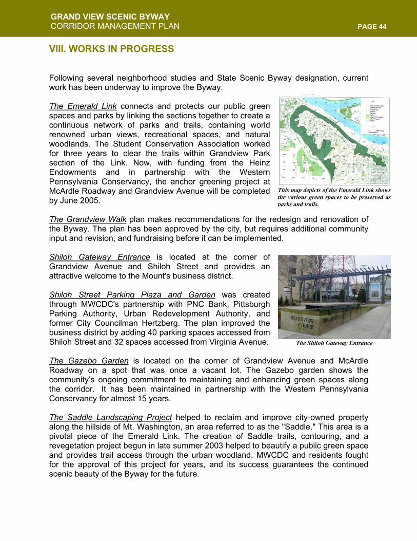
GRAND VIEW SCENIC BYWAY CORRIDOR MANAGEMENT PLAN PAGE 44
VIII. WORKS IN PROGRESS Following several neighborhood studies and State Scenic Byway designation, current work has been underway to improve the Byway. The Emerald Link connects and protects our public green spaces and parks by linking the sections together to create a continuous network of parks and trails, containing world renowned urban views, recreational spaces, and natural woodlands. The Student Conservation Association worked for three years to clear the trails within Grandview Park section of the Link. Now, with funding from the Heinz Endowments and in partnership with the Western Pennsylvania Conservancy, the anchor greening project at McArdle Roadway and Grandview Avenue will be completed by June 2005. The Grandview Walk plan makes recommendations for the redesign and renovation of the Byway. The plan has been approved by the city, but requires additional community input and revision, and fundraising before it can be implemented. Shiloh Gateway Entrance is located at the corner of Grandview Avenue and Shiloh Street and provides an attractive welcome to the Mount's business district. Shiloh Street Parking Plaza and Garden was created through MWCDC's partnership with PNC Bank, Pittsburgh Parking Authority, Urban Redevelopment Authority, and former City Councilman Hertzberg. The plan improved the business district by adding 40 parking spaces accessed from Shiloh Street and 32 spaces accessed from Virginia Avenue. The Gazebo Garden is located on the corner of Grandview Avenue and McArdle Roadway on a spot that was once a vacant lot. The Gazebo garden shows the community’s ongoing commitment to maintaining and enhancing green spaces along the corridor. It has been maintained in partnership with the Western Pennsylvania Conservancy for almost 15 years. The Saddle Landscaping Project helped to reclaim and improve city-owned property along the hillside of Mt. Washington, an area referred to as the "Saddle." This area is a pivotal piece of the Emerald Link. The creation of Saddle trails, contouring, and a revegetation project begun in late summer 2003 helped to beautify a public green space and provides trail access through the urban woodland. MWCDC and residents fought for the approval of this project for years, and its success guarantees the continued scenic beauty of the Byway for the future.
This map depicts of the Emerald Link showsthe various green spaces to be preserved asparks and trails.
The Shiloh Gateway Entrance
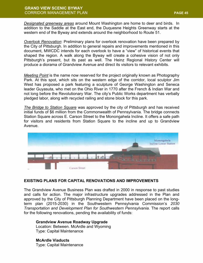
GRAND VIEW SCENIC BYWAY CORRIDOR MANAGEMENT PLAN PAGE 45
Designated greenway areas around Mount Washington are home to deer and birds. In addition to the Saddle at the East end, the Duquesne Heights Greenway starts at the western end of the Byway and extends around the neighborhood to Route 51. Overlook Renovation: Preliminary plans for overlook renovation have been prepared by the City of Pittsburgh. In addition to general repairs and improvements mentioned in this document, MWCDC intends for each overlook to have a “view” of historical events that shaped the region. A walk along the Byway will create a cohesive vision of not only Pittsburgh’s present, but its past as well. The Heinz Regional History Center will produce a diorama of Grandview Avenue and direct its visitors to relevant exhibits. Meeting Point is the name now reserved for the project originally known as Photography Park. At this spot, which sits on the western edge of the corridor, local sculptor Jim West has proposed a park featuring a sculpture of George Washington and Seneca leader Guyasuta, who met on the Ohio River in 1770 after the French & Indian War and not long before the Revolutionary War. The city’s Public Works department has verbally pledged labor, along with recycled railing and stone block for this park. The Bridge to Station Square was approved by the city of Pittsburgh and has received initial funds of $6 million from the Commonwealth of Pennsylvania. The bridge connects Station Square across E. Carson Street to the Monongahela Incline. It offers a safe path for visitors and residents from Station Square to the incline and up to Grandview Avenue. EXISTING PLANS FOR CAPITAL RENOVATIONS AND IMPROVEMENTS The Grandview Avenue Business Plan was drafted in 2000 in response to past studies and calls for action. The major infrastructure upgrades addressed in the Plan and approved by the City of Pittsburgh Planning Department have been placed on the long-term plan (2015-2030) in the Southwestern Pennsylvania Commission’s 2030 Transportation and Development Plan for Southwestern Pennsylvania. The report calls for the following renovations, pending the availability of funds:
Grandview Avenue Roadway Upgrade Location: Between. McArdle and Wyoming Type: Capital Maintenance McArdle Viaducts Type: Capital Maintenance

GRAND VIEW SCENIC BYWAY CORRIDOR MANAGEMENT PLAN PAGE 46
McArdle Roadway Upgrade Location: S. 10th St. to Grandview Ave. Type: Capital Maintenance
Additionally, normal routine maintenance can be expected, but will not have an impact on the intrinsic qualities of the Byway.
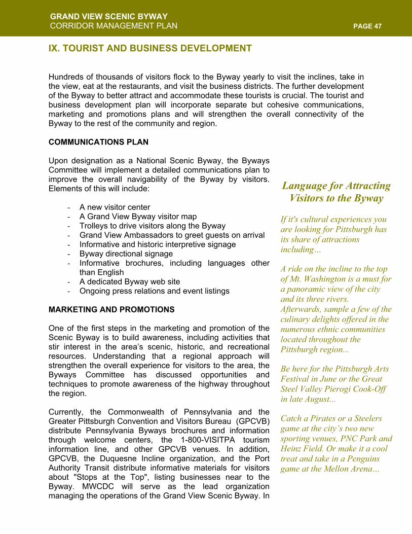
GRAND VIEW SCENIC BYWAY CORRIDOR MANAGEMENT PLAN PAGE 47
Language for Attracting Visitors to the Byway
If it's cultural experiences you are looking for Pittsburgh has its share of attractions including… A ride on the incline to the top of Mt. Washington is a must for a panoramic view of the city and its three rivers. Afterwards, sample a few of the culinary delights offered in the numerous ethnic communities located throughout the Pittsburgh region... Be here for the Pittsburgh Arts Festival in June or the Great Steel Valley Pierogi Cook-Off in late August... Catch a Pirates or a Steelers game at the city’s two new sporting venues, PNC Park and Heinz Field. Or make it a cool treat and take in a Penguins game at the Mellon Arena…
IX. TOURIST AND BUSINESS DEVELOPMENT
Hundreds of thousands of visitors flock to the Byway yearly to visit the inclines, take in the view, eat at the restaurants, and visit the business districts. The further development of the Byway to better attract and accommodate these tourists is crucial. The tourist and business development plan will incorporate separate but cohesive communications, marketing and promotions plans and will strengthen the overall connectivity of the Byway to the rest of the community and region. COMMUNICATIONS PLAN Upon designation as a National Scenic Byway, the Byways Committee will implement a detailed communications plan to improve the overall navigability of the Byway by visitors. Elements of this will include:
- A new visitor center - A Grand View Byway visitor map - Trolleys to drive visitors along the Byway - Grand View Ambassadors to greet guests on arrival - Informative and historic interpretive signage - Byway directional signage - Informative brochures, including languages other
than English - A dedicated Byway web site - Ongoing press relations and event listings
MARKETING AND PROMOTIONS One of the first steps in the marketing and promotion of the Scenic Byway is to build awareness, including activities that stir interest in the area’s scenic, historic, and recreational resources. Understanding that a regional approach will strengthen the overall experience for visitors to the area, the Byways Committee has discussed opportunities and techniques to promote awareness of the highway throughout the region. Currently, the Commonwealth of Pennsylvania and the Greater Pittsburgh Convention and Visitors Bureau (GPCVB) distribute Pennsylvania Byways brochures and information through welcome centers, the 1-800-VISITPA tourism information line, and other GPCVB venues. In addition, GPCVB, the Duquesne Incline organization, and the Port Authority Transit distribute informative materials for visitors about "Stops at the Top", listing businesses near to the Byway. MWCDC will serve as the lead organization managing the operations of the Grand View Scenic Byway. In
GRAND VIEW SCENIC BYWAY CORRIDOR MANAGEMENT PLAN PAGE 48
order to better market and promote the Byway, MWCDC will enhance ongoing relationships and create new cooperative partnerships with the following organizations and community groups:
- Greater Pittsburgh Convention and Visitors Bureau - Urban Redevelopment Authority, Mainstreets Program - Emerald Link - Society for the Preservation of the Duquesne Incline - Port Authority Transit - Downtown Pittsburgh Partnership - South Side Local Development Company - National Historic Road - Ohio River Scenic Drive - Local chambers of commerce - Restaurant, business, and condo associations - Ft. Pitt Museum - River Life Task Force - Point State Park - Andy Warhol Museum - Heinz Hall - Carnegie Museums of Pittsburgh - Phipps Conservatory and Botanical Gardens - National Aviary Heinz Regional History Center - Carnegie Science Center - Gateway Clipper Fleet - Station Square Association - Carnegie Library - Other local community development corporations - Local community groups - Area universities
BYWAY BENEFICIARIES Successful Federal designation of the Grand View Scenic Byway will have a major impact, and its realization will provide benefits to many, including: Pittsburgh Visitors: Over a million visitors come to the Byway each year. The view from Mt. Washington is one of Pittsburgh's "First Day Attractions". Residents proudly bring visitors to take in the panoramic view of Pittsburgh's Three Rivers, the downtown skyline, and surrounding neighborhoods nestled into Pittsburgh's unique landscape. MWCDC looks forward to continuing to enhance the appearance and hospitality of the Grand View Scenic Byway with the support of both the Pennsylvania and National Scenic Byway programs. Pittsburgh Residents: The residents of Pittsburgh and their descendents will be the primary beneficiaries of the Byway and the successful continued development of the Byway will guarantee the long-term enjoyment by residents and generations to come. Residents from around the city and County currently enjoy the Byway.
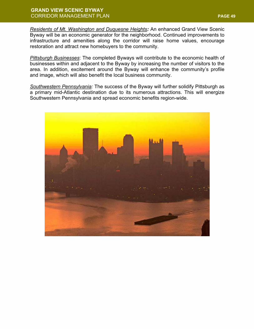
GRAND VIEW SCENIC BYWAY CORRIDOR MANAGEMENT PLAN PAGE 49
Residents of Mt. Washington and Duquesne Heights: An enhanced Grand View Scenic Byway will be an economic generator for the neighborhood. Continued improvements to infrastructure and amenities along the corridor will raise home values, encourage restoration and attract new homebuyers to the community. Pittsburgh Businesses: The completed Byways will contribute to the economic health of businesses within and adjacent to the Byway by increasing the number of visitors to the area. In addition, excitement around the Byway will enhance the community’s profile and image, which will also benefit the local business community. Southwestern Pennsylvania: The success of the Byway will further solidify Pittsburgh as a primary mid-Atlantic destination due to its numerous attractions. This will energize Southwestern Pennsylvania and spread economic benefits region-wide.
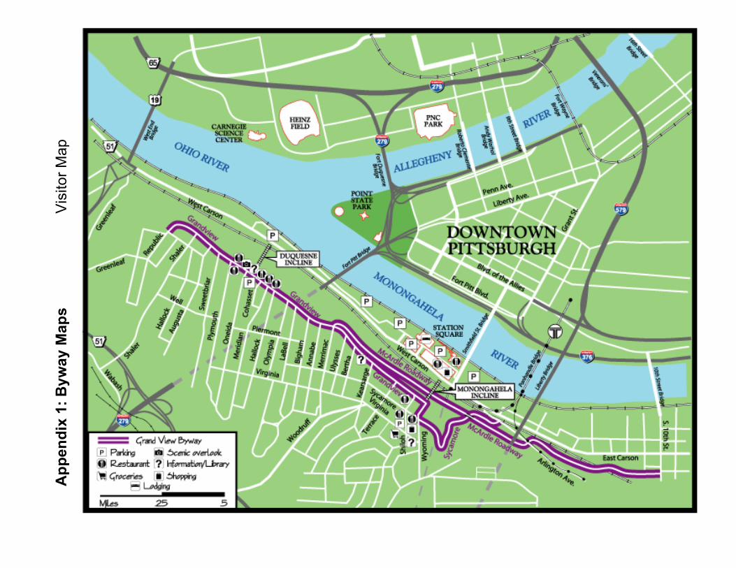
App
endi
x 1:
Byw
ay M
aps
Vis
itor M
ap
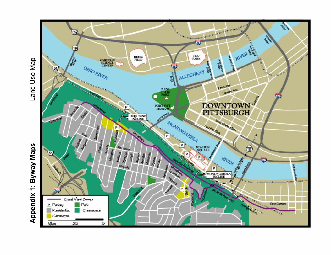
A
ppen
dix
1: B
yway
Map
s
La
nd U
se M
ap
Appendix 2: List of Byway Stakeholders and Businesses
BUSINESS TYPE BUSINESS/ORGANIZATION ADDRESS STREET PHONE
Restaurants& Bars Satalio's 27 Bailey Ave. 431-9855
La Tavola 1 Boggs Ave. 481-6627Colleen's Place 9 Boggs Ave. 381-6770Grandview Inn 1102 Grandview Ave.Le Mont 1114 Grandview Ave. 431-3100Tin Angel 1200 Grandview Ave. 381-1919Pasquarellis 1204 Grandview Ave. 431-1660The Cliffside Grandview Ave. 431-6996Grandview Saloon 1212 Grandview Ave. 431-1400Club Rios 1216 Grandview Ave.Duquesne Incline Grandview Ave.Georgetowne Inn 1230 Grandview Ave. 481-4424Monteray Bay 1411 Grandview Ave. 481-4414Difiores Ice Cream 120 Shiloh St. 381-4640Shiloh Inn 125 Shiloh St. 431-4000Redbeard's 201 Shiloh St. 431-3730Golden Palace 206 Shiloh St. 481-8500Sloppy Joe's 215 Shiloh St. 381-4300Village 223 Shiloh St. 381-9221Rozlyn's Place 312 Shiloh St. 381-7800Shiloh Inn 121-123 Shiloh St. 431-4000Michael's 212-216 Shiloh St. 381-3323Sonny's Place 309 Shiloh St. 431-9908
Tanning Sun City Salon 1 Bailey Ave. 431-2221Video Vacant/For Rent 6 Bailey Ave. 481-3330
Conv/Gas Co-Gos 10 Bailey Ave. 431-6722Gulf 1 Virginia Ave. 431-2006BP Oil Co. 10 Virginia Ave. 431-6636Co-Go's 300 Virginia Ave.
Pharmacy The Medicine 20 Bailey Ave. 481-2400Rite-Aid 1 Grace St.Eckerd Drug 225 Shiloh St. 381-5184Mt. Washington 38-40 Southern Ave.
Page 1 of 4
Appendix 2: List of Byway Stakeholders and Businesses
BUSINESS TYPE BUSINESS/ORGANIZATION ADDRESS STREET PHONE
Offices Doctor's Office 20 Bailey Ave. 431-3911Doctor's Office 20 Bailey Ave. 381-1600Podiatrist 210 Shiloh St. 431-3911Doctor's Office 218 Shiloh St.Southeast Dental 229 Shiloh St. 488-1400Dentist 231 Shiloh St. 481-6688Dentist 234 Shiloh St. 431-8900Doctor's Office 304 Shiloh St.Mt. Washington 28 Southern Ave. 431-0711S Newton 6 Boggs Ave. 488-1920Waldo Insurance 126 Boggs Ave. 481-8900Sassano & 122 Shiloh St. 431-8000Law Office 221 Shiloh St.Vacant/For Rent 301 Shiloh St.Collyer Realty 308 Boggs Ave. 431-0500
Antiques Eve's Eden 7 Boggs Ave. 431-2977Hardware Mt. Washington's 12 Boggs Ave. 381-3332Jewlery Diamonds & Gold 17 Boggs Ave. 481-3830
Hair Salon
J. Alexandra's Hair Salon 20 Boggs Ave. 381-4234A Stitch In Time 131 Shiloh St.Sandy's Shears 17 Southern Ave. 481-1661Hair Hut 124 Virginia Ave. 431-1650Regina's Hair Salon 218 Shiloh St. 381-2264Louis A. Haircare 208 Virginia Ave. 431-6660
Variety/Gift McGoo's Variety 100 Boggs Ave. 481-8358
Eiseltown Gift Shop 207 Shiloh St. 488-8610Josephines Card & Gifts 232 Shiloh St. 381-2255
SuppliesFrozen Eggs Bakery Supplies 121 Boggs Ave. 431-4828Kauf Supply Co., Inc. 38 Southern Ave. 381-5184
Pet Store Vacant/For Rent 153 Boggs Ave. 381-8988Pizza 202 Boggs Ave. 431-0887
Bellisimo's Pizza 200 Shiloh St. 488-7273
Page 2 of 4
Appendix 2: List of Byway Stakeholders and Businesses
BUSINESS TYPE BUSINESS/ORGANIZATION ADDRESS STREET PHONE
Cestone's Pizza 200 Virginia Ave. 431-3311Banks National City 122 Shiloh St. 431-6311
PNC 236 Shiloh St. 381-8200Parkvale 55 Wyoming St. 381-4711
Liquor PA Wine & Spirits 219 Shiloh St.Community
GroupMt. Washington Community Development Corporation 301 Shiloh St. 481-3220
FireStation Engine Co. #27 17 Virginia Ave.Grocery Foodland 125 Virginia Ave. 431-1566Flowers Wallace Florist 138 Virginia Ave. 800-245-6312
Funeral Brusco Funeral Home 214 Virginia Ave. 381-2323Slater & Sons 301 Virginia Ave. 381-3345
Laundry Virginia Ave. Laundry Co. 230 Virginia Ave. 343-4702
AutoMoreno's Auto Repair 351 Wyoming St.M-F Automation 355 Wyoming St.
KarateStrikeforce Academy 24 Southern Ave. 381-6611
Plaques Dave's Plaques 5 Boggs Ave. 488-6833Clothing ALL-OUT Clothing 15 Boggs Ave. 481-2008Offices inTrimont Reedaum Associates
A/C FinancialDr. Paul GaffneyGrice ChiropracticCapital Realty GroupMollica & Murray Attorneys at LawTucker, Johnson & SmeltzerCouch Mollica Travel AgencySterling Financial GroupDr. Vincent Petraglia & Associates
Meeting Facilities Urban Mountain Gathering Place 213 Bailey 381-8647Church Mt. Washington Congregational Church 65 Southern 381-1481
Page 3 of 4
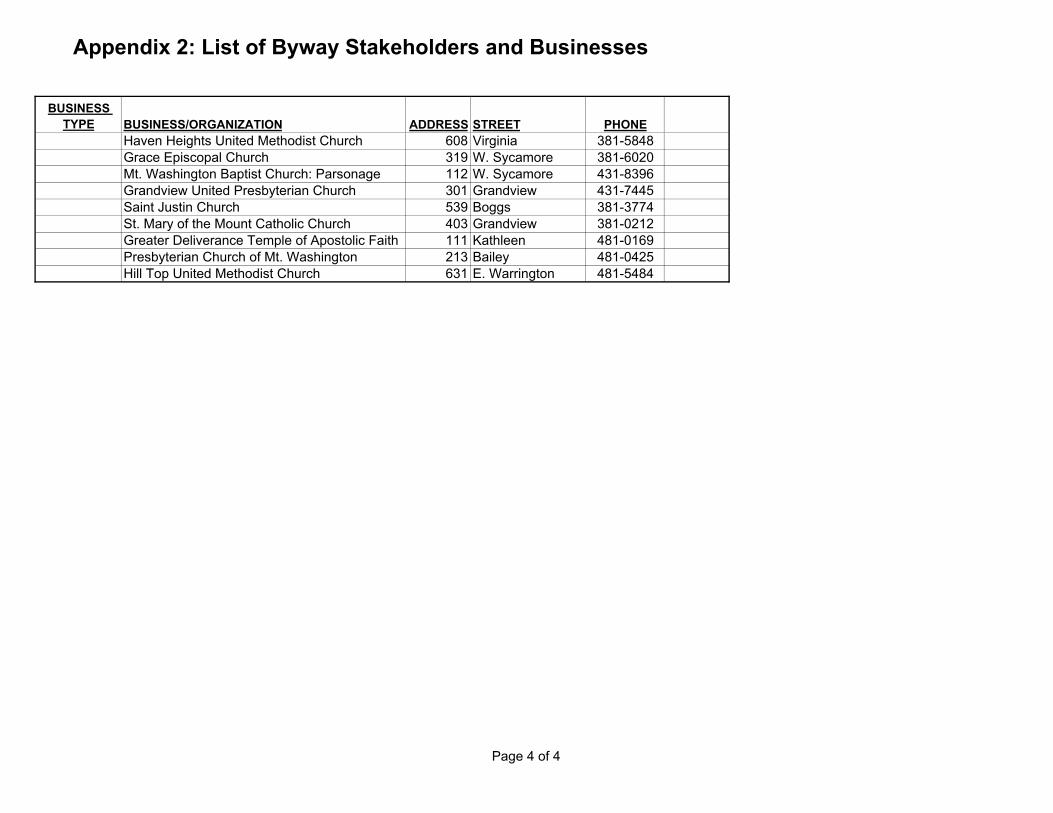
Appendix 2: List of Byway Stakeholders and Businesses
BUSINESS TYPE BUSINESS/ORGANIZATION ADDRESS STREET PHONE
Haven Heights United Methodist Church 608 Virginia 381-5848Grace Episcopal Church 319 W. Sycamore 381-6020Mt. Washington Baptist Church: Parsonage 112 W. Sycamore 431-8396Grandview United Presbyterian Church 301 Grandview 431-7445Saint Justin Church 539 Boggs 381-3774St. Mary of the Mount Catholic Church 403 Grandview 381-0212Greater Deliverance Temple of Apostolic Faith 111 Kathleen 481-0169Presbyterian Church of Mt. Washington 213 Bailey 481-0425Hill Top United Methodist Church 631 E. Warrington 481-5484
Page 4 of 4
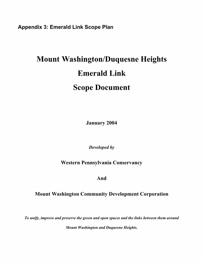
Appendix 3: Emerald Link Scope Plan
Mount Washington/Duquesne Heights
Emerald Link
Scope Document
January 2004
Developed by
Western Pennsylvania Conservancy
And
Mount Washington Community Development Corporation
To unify, improve and preserve the green and open spaces and the links between them around
Mount Washington and Duquesne Heights.
- 2 - WPC & MWCDC January 2004
Prologue The purpose of this Scope document is to begin to define the Emerald Link project. The completion of this document transforms the Emerald Link from a grand idea into a set of concrete parameters to be built upon in the next steps of project planning. The Scope document will act as the framework for the development of a larger, more detailed Master Implementation Plan to be completed in 2004-2005. The Master Implementation Plan will be a planning tool that will be used by a wide range of constituents and will act as a model for high quality environmental and community planning. The creation of the Master Implementation Plan will include an assessment of existing conditions, the establishment of actionable next steps for implementation, and the creation of a preliminary fundraising plan. The Emerald Link project intends to create a comprehensive green infrastructure. As the roads and bridges form a concrete infrastructure for our city, the Parks, trails and natural amenities comprise the green infrastructure that supports the life of our community. We are faced with a unique and special opportunity to create a large, comprehensive and contiguous green infrastructure in an urban environment. The groundswell of support for the Emerald Link project to date has been tremendous and reflects the sincere commitment of our community to improving and preserving the special natural places that comprise the Emerald Link. The specific mission of the Emerald Link project is: to unify, improve and preserve the green and open spaces and the links between them around Mount Washington and Duquesne Heights. The executed results of the Emerald Link project will have a lasting impact on the region and act as a model for high quality environmental community planning. The Emerald Link project ultimately strives to have a meaningful civic impact; it will raise awareness about the places in the Emerald Link and related environmental issues, enhance Pittsburgh’s image both inside and outside the City, set an example for successful collaboration among nonprofit partners with shared goals, and create a positive process for public involvement and advocacy. The beneficiaries will include the natural environment, residents of Mt. Washington and Duquesne Heights, Pittsburgh residents, Pittsburgh visitors, and the Western Pennsylvania region. Western Pennsylvania Conservancy and the Mt. Washington Community Development Corporation are grateful to The Heinz Endowments for providing the funding to develop and produce this document. We also thank those individuals and organizations that provided assistance in gathering information for this document.
- 3 - WPC & MWCDC January 2004
CONTENTS
• � Executive Summary Page 6 Project Introduction 6 Mission Statement and Vision 6 Project Background 7 Project Significance 7
Summary of Emerald Link Goals 10 Summary of Scope Document Conclusions 11
• Stakeholders Page 13
• Emerald Link Description
1. Grandview Park Page 16 Location Size History and Physical Characteristics Assessment Zoning Natural Resources Political and Community Issues Goals Benefit/Result Action Items Funding Sustainability
2. The Saddle Page 19
Location Size History and Physical Characteristics Assessment Zoning Natural Resources Political and Community Issues Goals Benefit/Result Action Items Funding Sustainability
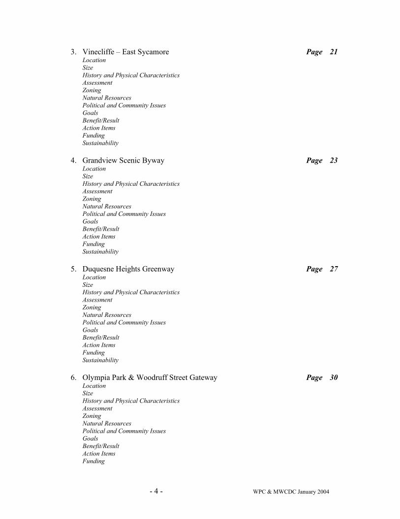
- 4 - WPC & MWCDC January 2004
3. Vinecliffe – East Sycamore Page 21 Location Size History and Physical Characteristics Assessment Zoning Natural Resources Political and Community Issues Goals Benefit/Result Action Items Funding Sustainability
4. Grandview Scenic Byway Page 23
Location Size History and Physical Characteristics Assessment Zoning Natural Resources Political and Community Issues Goals Benefit/Result Action Items Funding Sustainability
5. Duquesne Heights Greenway Page 27
Location Size History and Physical Characteristics Assessment Zoning Natural Resources Political and Community Issues Goals Benefit/Result Action Items Funding Sustainability
6. Olympia Park & Woodruff Street Gateway Page 30
Location Size History and Physical Characteristics Assessment Zoning Natural Resources Political and Community Issues Goals Benefit/Result Action Items Funding
- 5 - WPC & MWCDC January 2004
Sustainability 7. Mount Washington Park/Dilworth Field Page 32
Location Size History and Physical Characteristics Assessment Zoning Natural Resources Political and Community Issues Goals Benefit/Result Action Items Funding Sustainability
• Development/Next Steps Page 34
• Resources Page 36
• Appendices A. Summary of Community Process Page 39 B. Project Contact List (detailed contact information) Page 40 C. Current Condition (Map) Page 41 D. Emerald Link Study Area (Map) Page 42
- 6 - WPC & MWCDC January 2004
Executive Summary
Emerald Link Project Introduction The undertaking outlined in this document is colloquially called the Emerald Link project. The genesis of this name reflects the purpose of the project. “Emerald” refers to the green and open spaces that surround Mt. Washington and Duquesne Heights. “Link” refers to the goal that these spaces be strengthened and linked, both to each other and to concurrent greening efforts around the City of Pittsburgh. The Emerald Link project will include a critique of this name through a formal market analysis during the creation of the Master Implementation Plan. The Emerald Link study area is approximately 264 acres of green and open space around Mt. Washington and Duquesne Heights beginning at the Northeast portion of Mt. Washington at Grandview Park and moving counter clockwise through the Saddle, Vinecliffe/East Sycamore, Grandview Avenue, Duquesne Heights Greenway, Olympia Park and Woodruff Street Gateway, and ending at Mt. Washington Park (see map in Appendix D). This scope document was developed by Western Pennsylvania Conservancy (WPC) and Mt. Washington Community Development Corporation (MWCDC).
Emerald Link Mission Statement & Vision The Emerald Link project Mission Statement and Vision is:
Mission To unify, improve and preserve the green and open spaces and the links between them around Mount Washington and Duquesne Heights.
Vision Our initiative will preserve and dramatically improve the urban green and open spaces of Mount Washington/Duquesne Heights, which constitute a recognized community, city and regional asset. This initiative will contribute to the economic development and well-being of the region; provide healthy, safe and accessible urban recreation areas; act as a model for high quality environmental planning; and attract tourism.

- 7 - WPC & MWCDC January 2004
Emerald Link Project Background The Emerald Link concept emerged in 2000 when community members and stakeholders began to recognize the importance of green spaces to the quality of life of Pittsburghers and to the economic vitality of the region. Ironically, while these areas are increasingly recognized as important, they are also becoming endangered by neglect and ecological fragility. The idea for a continuous "conserved" area jelled in 2001 during conversations between the City of Pittsburgh, MWCDC and the Allegheny County Regional Asset District regarding the Grandview Avenue Overlooks. The MWCDC realized that, although Mt. Washington's vista points are a high profile attraction, they are only part of a larger, regional amenity – the comprehensive and contiguous 264 acres of undeveloped land that rings the Mount. The groundswell of support for the Emerald Link concept has been tremendous. Community members enthusiastically support the Emerald Link project. Various local and regional nonprofit organizations have also expressed their support and their desire to form partnerships to connect related efforts. Governmental agencies at the City, County and State level have also indicated preliminary support for the project. Progress to date has been positive. In October 2003 the Emerald Link project received a grant of $50,000 from The Heinz Endowments to conduct preliminary research and define the initial scope of the project. This scope document is a result of these efforts. The scope document represents the first steps toward creating a larger, more comprehensive Master Implementation Plan that will allow the project participants to define actionable next steps. MWCDC presented the Emerald Link project and its status at its November 2003 community forum. MWCDC Open Space Task Force, a committee of volunteers, has taken a leadership role in representing the public’s interest in this effort. The Task Force was instrumental in drafting and approving a mission statement for the Emerald Link project (see Mission Statement & Vision). The next step for the Emerald Link project is to create a Master Implementation Plan (MIP) in 2004/ 2005. The MIP will be a planning tool that will provide a detailed guide for implementation of all project goals, as preliminarily outlined in this document. The MIP will analyze and map each component of the project and assess ownership, zoning, natural resources, community impact, economic impact, and sustainability issues. The MIP will also provide a guide for the identification of additional funding opportunities from government, foundation and private sources. As part of this planning process, the Emerald Link project participants will simultaneously investigate and identify various strategies for protecting the land for future generations including potential acquisition of land into a conservancy. The plan will also identify areas that may be appropriate for future real estate development.
Emerald Link Project Significance The completion of the Emerald Link project is vital to the long-term viability of our region. The Emerald Link project addresses prominent large green areas, which collectively have an enormous impact on the day-to-day life of the residents of the City and those who visit the City each day. The executed results of the Emerald Link project will have a lasting impact on the region and act as a model for high quality environmental planning. The implementation of the Emerald Link will have a meaningful civic impact that includes: raising awareness about environmental issues, enhancing Pittsburgh’s image both inside and outside the City, setting an example for successful collaboration among nonprofit organizations with shared goals, and creating a positive process for public involvement and advocacy.
- 8 - WPC & MWCDC January 2004
Specific areas of significance include: Environment: The Emerald Link study area includes 264 acres of land that are key assets of our community. The Emerald Link project recognizes the significance of these assets as defining to the character of our region and strives to preserve them in perpetuity. Some of the challenges in preserving this land include: extreme slopes and hillsides, under-mining, years of neglect and misuse, overgrowth of invasive species, erosion problems, unusable or nonexistent trails, pollution and dumping. As part of the Master Implementation Plan, the Emerald Link team will evaluate each link component and identify and document potential improvements, protection strategies, project benchmarks, and sustainability plans. The Master Implementation Plan will include a science based natural resource assessment of each component in the Link. The MIP will result in executable tasks for each element of the link. Sustainability: The implementation of the Emerald Link project must be sustainable. Careful planning, high quality environmental design, and development of resources for stewardship will provide a pattern book for maintaining and improving the land over decades to come. Long-term stewardship efforts would include organizing and educating community members to maintain land and creating funds for maintenance. Economic Development: The Emerald Link project will have a wide economic impact that will impact the residential housing market, the health of the local business districts, tourism, and the ability of the City of Pittsburgh to attract new residents. The health of the local real estate market is closely tied to the health of neighboring green spaces. Numerous studies indicate that cared for green space increases property values in a neighborhood. The cared for Link, including the improvement of Grandview Avenue, will be an economic generator for the Mt. Washington and Duquesne Heights communities. The Emerald Link project will greatly improve the amenities to Mt. Washington/Duquesne Heights residents, will enhance home values, and will attract new home buyers to the community. Furthermore, addressing zoning and boundary anomalies, establishing stewardship programs for each Link, and executing the improvements recommended in the Master Implementation Plan will all directly benefit the residential homeowners that are adjacent to the Link.
In addition to its impact on the residential housing market, the executed Emerald Link project will have a significant impact on the business districts of the community. The Emerald Link will generate excitement and increased visits by residents and tourists alike. This will, in turn, attract new businesses to the community. MWCDC believes that the completed Emerald Link project will greatly contribute to the health of the existing business districts, such as Grandview restaurant row and the Shiloh Street Business District, and will also improve the connections between Mt. Washington and Station Square. Currently, visitors to the City of Pittsburgh have no central point at which to access the Emerald Link nor can they hike continuously around the Link. There is an absence of informational signage along the way and the condition of currently popular tourist destinations (such as the Grandview Avenue Overlooks) is poor. It is the goal of the Emerald Link project to create a visitor center, information signage, and a continuous trail system around the Link. These improvements, as well as the improvements to each individual Link, will significantly enhance the outdoor experience of tourists and residents alike. In addition, leaders of our region are seeking to attract young professional talent in order to strengthen the economy. Urban recreation opportunities are a key draw for this target market. The Emerald Link project will tie into these efforts by improving areas for hiking and outdoor recreation.
- 9 - WPC & MWCDC January 2004
Families: Historically, Parks, green spaces and playgrounds have offered children of all economic levels healthy play areas. This is particularly important in an urban environment that is home to children who may not have access to other resources. Similarly, the Link will provide a laboratory for City children and adolescents to learn about wildlife and environment so that they can grow into the future stewards of the land. Education: During the MIP phase of the project, educational opportunities will be investigated. However, a number of educational opportunities for the Emerald Link project have already been identified. First, outdoor teaching programs could be initiated as part of the project. Grandview Elementary School, at the edge of Grandview Park, has initiated an educational program for its students as part of the Emerald Link project. Second, the Student Conservation Association (SCA), a nonprofit group that organizes students to do environmental work, has completed extensive work to reclaim trails in the Emerald Link project area. Finally, the Emerald Link project will include the creation of an Emerald Link visitor center that will include an educational component that addresses ecological and historic topics.
Evaluation The Master Implementation Plan will include the creation of quantitative and qualitative measures to evaluate the outcomes for each Link. Examples of quantitative measures would include: funds invested or leveraged, properties acquired or conserved, properties rezoned, number of trails created, number of planting areas installed, and stewardship funds raised. Levels of participation at community meetings, volunteer projects, and educational programs will also be measured. Evaluation methodologies will be developed as part of the development of the MIP.
- 10 - WPC & MWCDC January 2004
Summary of Emerald Link Goals The Emerald Link project will create a comprehensive green infrastructure that will achieve the following goals:
Ecological • Preserve and protect the natural beauty of the Emerald Link for future generations • Preserve and protect the City Parks that are located inside the Link (Grandview Park, Grand View Scenic Byway,
Olympia Park, Mt. Washington Park) • Provide safe, healthy green spaces and playgrounds for families and children • Understand each Link through a detailed science based assessment of the natural resources and amenities in each Link • Create and implement high quality environmental plans that promote sustainable native plants and trees and the
institution of sound ecological practices • Create a continuous trail system around the Emerald Link
Sustainable • Ensure appropriate parcel boundaries, zoning and ownership needed for long-term conservation • Establish a stewardship program for each major piece of land and/or trail system including creating a constituency to
care for the land and the financial resources to support it • Engage a healthy community process around the project that brings together the members of the local community and
other Emerald Link stakeholders
Educational • Provide educational opportunities whereby the Link acts as a natural laboratory for City children and adolescents to
learn about wildlife and environment so that they can grow into the future stewards of the land • Create an Emerald Link visitor center that will include an educational component to address ecological and historic
topics
- 11 - WPC & MWCDC January 2004
Summary of Scope Document Conclusions This scope document establishes preliminary goals, benefits, and initial priority areas for each of the seven links. The specific high priority goals for each major component of the Link are as follows. Moderate priority goals are not listed here but are outlined in the Property Overview section of this document.
1. Grandview Park • Preserve and enhance the existing Park • Establish a program for Park stewardship by supporting and expanding on existing community efforts • Create a vibrant educational program for students and the public • Monitor and promote responsible real estate development on the edges of the Park • Study and improve the Park mapping and zoning to ensure consistency for long-term preservation
2. The Saddle • Preserve the natural beauty of the hillside, prevent erosion, institute ecologically sound practices, and encourage
native plant species through unified ownership and conservation strategies • Resolve the conflict regarding development that surrounds the Saddle • Provide an outstanding entrance component of the Grand View Scenic Byway
3. Vinecliffe – East Sycamore • Monitor private development efforts and work with developers to make sure developments complement the mountain
and that site development is consistent with the Emerald Link project goals
4. Grand View Scenic Byway • Transform this nationally recognized asset into a stunning destination for visitors and local residents alike by
completing extensive and comprehensive renovations • Reclaim the hillside (including McArdle Roadway hillside) from neglect and promote native four-season plantings • Work with the City of Pittsburgh to address maintenance issues on its property • Address any zoning issues that will affect the Link to maintain a balance between development and scenic open space • Identify and develop conservation strategies of key privately held properties
5. Duquesne Heights Greenway • Investigate strategies to protect the Greenway • Create an active, educational Emerald Link Visitor Center at the Duquesne Heights Community Center to serve both
the local population and visitors • Ensure attractive, responsibly executed transportation improvements at the West End Circle through a close working
relationship with PennDot and the West Pittsburgh Partnership • Develop a cohesive walking trail system
- 12 - WPC & MWCDC January 2004
6. Olympia Park &Woodruff Street Gateway • Develop a Park improvement plan to include such areas as landscaping, trail reclamation, and improvements to safety,
accessibility and signage • Develop a cohesive walking trail system including enhancing the trail through the gully to connect Olympia Park with
Route 51 and Seldom Seen • Engage residents in the conservation and trail development projects
7. Mt. Washington Park/Dilworth Field • Identify and develop conservation strategies of key privately held properties • Create a safe pedestrian connection across Route 51 connecting the Emerald Link to Seldom Seen • Engage the residents, including those in the area known as “the Hollow” in cleanup, planting, trail clearance and
maintenance efforts
- 13 - WPC & MWCDC January 2004
Emerald Link Stakeholders The project stakeholders are described below. In addition, a contact list for the project is attached in the Appendix to this document. Scope Document Participants This scope document was developed by Western PA Conservancy (WPC) and the Mt. Washington Community Development Corporation (MWCDC). Western PA Conservancy (WPC) Western Pennsylvania Conservancy's mission is to have the places we care about by connecting people to the natural world, protecting natural lands, promoting healthy and attractive communities, and preserving Fallingwater. Since its inception in 1932, the Conservancy has protected more than 210,000 acres of natural lands in Pennsylvania. The organization continues to work to secure lands of ecological significance that offer recreational and scenic values. The following Strategic Drivers provide the framework for planning of all Western Pennsylvania Conservancy programs and activities: 1) Conserve the natural and cultural heritage of western Pennsylvania; 2) Inspire a conservation ethic through education and volunteer actions; 3) Collaborate with communities; 4) Advance public policy and public funding for conservation; and 5) Maintain a healthy organization. WPC is a 501c(3) corporation and has an $11 million annual operating budget. WPC became involved in the Emerald Link project because WPC’s mission goals and those of the Emerald Link project are perfectly matched. WPC brings its experience managing large greening projects and its expertise in land conservation, ecology, native species, hillside reclamation, and landscape design. Mount Washington Community Development Corporation (MWCDC) The mission of MWCDC is to foster economic development, to preserve and improve the structural and natural environment, and to coordinate its efforts with those of government, non-profit and private entities whose missions have impact on their neighborhoods. MWCDC is a membership organization with over 13 years experience partnering with citizens, government, investors, institutions, and nonprofits to develop projects and programs for the benefit and enhancement of the Mount Washington and Duquesne Heights communities. MWCDC has also been the developer/project coordinator for the community's renovated and expanded grocery store, new pharmacy, bi-level Shiloh Parking Plaza, and the twenty-unit senior citizen apartment building. MWCDC's first major planning project was to create a master plan for the renovation of Grandview Avenue and expansion of its tourist amenities. The first component of that project, the remaking of the Shiloh at Grandview Entrance was completed in 2003. MWCDC is a 501c(3) corporation. It's budget ranges between $150,000 to $300,000, depending upon the number of current construction projects. The Emerald Link vision was developed between 2000 and 2003 as community stakeholders began to recognize the importance of these natural assets to the region’s quality of life. MWCDC Open Space Task Force (OSTF) was the first to recognize and articulate that the high profile Grand View area (now designated as a Scenic Byway) was only part of a much larger asset – the entire continuous green space and hillsides around the mountain. OSTF members saw an opportunity to create a conservation area to be enjoyed by residents and tourists alike. A consultant was hired to begin to identify public property boundaries and to establish the potential connections between existing formal recreation areas and new trails and parks at the river front. Taking the lead from Boston’s Emerald Necklace, the Mount green space became the Emerald Link.
- 14 - WPC & MWCDC January 2004
MWCDC brings to the Emerald Link project its knowledge of the properties and people in the Emerald Link study area, its experience organizing effective public processes, and its concern for the improvement and preservation of these lands. Other Emerald Link Project Participants The success of the Emerald Link project will depend on the successful collaboration of many project stakeholders. The relationships between these parties will evolve during the creation of the Master Implementation Plan. The City of Pittsburgh owns the vast majority of the land in the Emerald Link project, either as Park land or as real estate. The Emerald Link project participants look forward to a positive collaboration with the City on this project. The Allegheny Land Trust has also expressed interest in working in collaboration with the Emerald Link team to devise and implement strategies to protect the land in the Link. The Allegheny Land Trust (ALT) is a 501c(3) organization incorporated in 1993 to protect land of natural value in and adjacent to Allegheny County. The ALT helps local people save local land that contributes to the scenic, recreational, educational, and environmental wealth of the community. ALT currently protect over 900 acres. Emerald Link Project Beneficiaries The successful implementation of the Emerald Link project will have a major impact. Its success will provide benefits to these entities: The Natural Environment The land in the Emerald Link area is at risk. Challenges include: extreme slopes and hillsides, under-mining, years of neglect and misuse, overgrowth of invasive species, erosion problems, unusable or nonexistent trails, pollution and dumping. In addition, this land is largely unprotected or cared for. The land, water, plants and animals in the Emerald Link are valuable assets that are integral to the character of our community and that deserve our full attention. The Emerald Link project scope includes a careful science based assessment of natural resources of each Link and the establishment of appropriate environmental goals and plans for implementation. In addition, the Master Implementation Plan will assess factors such as zoning, boundaries or ownership, which may affect the ability to protect the land in the long term. Pittsburgh Residents The residents of Pittsburgh and their descendents are the primary beneficiaries of the Emerald Link project. Residents from around the city and County currently enjoy the green and open spaces that comprise the Emerald Link. Unfortunately, trail access and poor conditions hinder their experience of these special places. The successful execution of the Emerald Link project will guarantee the long-term enjoyment by residents and generations to come. In addition, the educational programs that will be offered as part of the Emerald Link project will help to engage the community in the project and educate them about long-term stewardship of the land. Residents of Mt. Washington and Duquesne Heights Various studies have indicated that high quality green spaces contribute to the economic health of a neighborhood. The cared for Link, including the improvement of Grandview Avenue Scenic Byway, will be an economic generator for the neighborhood. Not only is the neglected City property in the Link not currently reaching its potential, in some cases, it is creating safety and health hazards. For example, prior to the intervention by the Grandview Park neighbors, the Park suffered from neglect, illegal activities, poor lighting, overgrown trails, and limited or no programming. Through the recent efforts of community volunteers, the Park has already seen significant improvements. Similarly, the cared for Link, will greatly improve the amenities to Mt. Washington/Duquesne Heights residents, will enhance home values, and will attract new home buyers to the community. Furthermore, addressing zoning and boundary anomalies, establishing stewardship programs for each Link, and executing the improvements recommended in the Master Implementation Plan will all directly benefit the residential homeowners that are adjacent to the Link.
- 15 - WPC & MWCDC January 2004
Pittsburgh Visitors Several high profile areas in the Link, such as the Grand View Scenic Byway, are heavily trafficked by tourists with over a million visitors each year. Residents find it troubling to escort out-of-town guests to the crumbling, littered Overlooks. The current condition of this area in no way matches similarly important destinations in other major cities. In addition, the lack of information available to visitors about the places in the Emerald Link could be corrected by the creation of the proposed centralized visitor center and improved signage throughout the Link. Pittsburgh Businesses The completed Emerald Link will contribute to the economic health of businesses within and adjacent to the Link by increasing the number of visitors to the area. In addition, excitement around the Emerald Link project will enhance the community’s profile and image which will also benefit the business community. Western Pennsylvania It is clear that the health of Pittsburgh greatly influences the health of the region. The Emerald Link is visible from Pittsburgh’s downtown, one of key economic seats of our Commonwealth. Mt. Washington/Duquesne Heights is an important keystone to Pittsburgh and one that is visible from all major traffic interchanges around the downtown area and on route to the airport.
- 16 - WPC & MWCDC January 2004
Emerald Link Description
LINK 1
Grandview Park: a historic City Park with magnificent views Location: Grandview Park is located on the Eastern part of Mt. Washington facing the Monongahela River. Emerald Street marks the eastern boundary of Grandview Park. On the north, the boundary is Arlington Avenue and the rear lot lines of several Arlington residential properties. William Street defines the northern and western boundary. Bailey and Bigbee Streets form the southern boundary. Grandview Elementary School is located at the edge of the park grounds. The park and its trails connect the Mount Washington, Allentown and South Side neighborhoods. Blocks 4M, 4H, 3J, 3K, 3N and 3P. Size: The central park parcel (3J-180) is 30.1 acres. The additional green parcels that surround the park (owned by the City or Three Taxing Bodies) bring the total acreage of this element to approximately 90 acres. History & Physical Characteristics: Grandview Park was created in 1897 when the City of Pittsburgh purchased the 18-acre Robinson Farm for $62,000. The plot of land surrounding the City Water Tanks was added to the park in 1909. The Overlook, designed by Grove, Schafer and Associates, was constructed during the summer of 1958 for Pittsburgh’s Bi-Centennial and continues to serve as a focal point today. Hiking trails, built in the 1930s by the WPA, are being restored by workers from the Student Conservation Association (SCA). Assessment: Current Ownership: Grandview Park is owned by the City of Pittsburgh. In studying the maps for the Park, several anomalies were discovered. First, the central park area is made up of a number of parcels that could be consolidated into a single parcel. Second, there are a number of parcels that appear to be held by Three Taxing Bodies (City, County and School District) or private owners. Finally, there are undeveloped properties on the edges of the Park that could be formally added into the Park. These issues need to be studied in detail as part of the Emerald Link master implementation plan. Current Zoning: Zoning is Parks and Open Space (PO). Natural Resources: The Park has one of the highest elevations in the City and contains beautiful mature trees with a wide variety of species. The Park is also home to the “Indian caves,” caves which have been approved by the City for preliminary archeological investigation, pending State approval.
- 17 - WPC & MWCDC January 2004
Political and Community Issues: • Grandview Park is supported by an active force of community volunteers. These volunteers formed a group called
the Grandview Park TOP (transforming our park). This organization has done extensive community organizing and planning, addressed various safety and maintenance issues, and coordinated with the SCA to do trail reclamation. TOP’s ambitions for the Park include addressing safety concerns (which include loitering and drug dealing on Park property), completing ongoing clean up efforts, beautifying the park, recreating the historic carousel, rebuilding the run down band stand, increasing park programming, and instituting an educational program. Through the efforts of TOP, the band stand which was previously unused is now being used for outdoor performances and movie nights.
• A private developer plans to create a 29-unit housing project next to the Grandview Park water towers. MWCDC
supports this development which includes an exchange of a portion of park space for land accessible from Beltzhoover Avenue. This land would be used for Park parking and restrooms.
• Grandview Elementary School educational leaders are actively involved in the community effort to restore Grandview
Park. As a result, a Park-based educational curriculum for 4th and 5th graders has been created. School District funds have been to support the use of the Park as a natural science resource for south Pittsburgh area school students.
• MWCDC received a $20,000 grant from the State DCED to restore the Historic Park steps; this combined with City of
Pittsburgh funding, made a dramatic improvement to the physical appearance to the Park. • The Park is part of City Planning’s Historic Park project. An evaluation of the park was to take place summer 2003.
City budget problems have put that project on hold. Goals: • Preserve and enhance the existing Park (high priority) • Establish a program for Park stewardship by supporting and expanding on existing community efforts (high priority) • Create a vibrant educational program for students and the public (high priority) • Monitor and promote responsible real estate development on the edges of the Park (high priority) • Study and improve the Park mapping and zoning to ensure consistency for long-term preservation (high priority) Benefit/Result: The Grandview Park area is the starting point of the Emerald Link and is one of the most architecturally significant outdoor element in the Link. It is a beautiful and heavily used public resource. The Emerald Link project goals will: a) preserve the Park in perpetuity; b) upgrade the condition of the Park and the resources offered; c) create a vibrant educational program based in the Park; d) provide the bridge between two neighborhoods, and e) create an economic benefit by increasing the value of the property adjacent to the cared for green space. Priority Areas: The Master Implementation Plan will identify and prioritize immediate action items for each Link. The following is a preliminary list of possible priority areas: • Study potential trail improvements including the possible creation of an East-West trail to link the Grandview Park
trail system to the Saddle’s new Castle Shannon Incline trail at William Street • Investigate condition of facilities that affect programming such as the band stand • Study the zoning and ownership issues associated with park parcels and take appropriate action • Strengthen and support the Park Constituency. • Review all Park-related research and studies already completed • Monitor related real estate developments • Understand and address safety concerns of residents neighboring the Park
- 18 - WPC & MWCDC January 2004
Potential Funding: Funding sources for this element need to be identified. Sustainability: The sustainability of this component requires a) the establishment of a stewardship program; b) the study and correction of any zoning anomalies; c) continued efforts for the creation of a sustainable trail system.
- 19 - WPC & MWCDC January 2004
LINK 2
The Saddle: former pathway of the Castle Shannon Incline Location: The Saddle gets its name from its saddle-like shape on the map. It is composed of properties south of the line formed by Carson Street, bounded to the South by William and Neff Streets, to the east by Port Authority property directly above the Liberty Tunnel, and to the west by East Sycamore Street. The central ‘Saddle’ area is a large green area that is encircled by residential properties. The undeveloped portion of the Saddle and consists of slopes, meadows and trees. The map shows these undeveloped properties in blocks 4G, 4H, 4C and 4L. Size: The undeveloped Saddle area is about 13 acres. History & Physical Characteristics: The Saddle is the former site of the Castle Shannon Incline, built in 1890 and demolished in 1964. This area was formerly owned by the Pittsburgh Railways. Concrete sections from the freight incline still remain. Large quantities of construction materials and fill were also dumped onto this land. This area also suffered tornado damage in 1998. Recent home developments on Cola and William Streets have eliminated some of the Saddle’s area of natural landscape and have created erosion problems. In addition, the southern slope of the Saddle is undermined with both coal mines and old coke ovens, some openings of which have been filled with industrial trash (metal, glass, concrete, etc). Long-time residents tell of underground fires that burned for years. It is possible that disturbing these areas for construction could cause ecological problems that might have far-reaching impact for the surrounding area and any areas fed by this watershed. In the summer of 2003, MWCDC commissioned a trail building and planting project in the central portion of the Saddle. Hikers can now walk through the undeveloped green area on trails that include a set of stairs in the green. Assessment: Current Ownership: Of the undeveloped land, 34 lots are owned by the City (Real Estate) or Three Taxing Bodies (City, County and School District) and 3 lots are privately held. Current Zoning: The undeveloped Saddle area is designated Parks and Open Space (PO). Natural Resources: This area has been the subject of significant community volunteerism. Work has been done to clear the area of industrial, residential and illegal dumping, clean the bordering roadsides, reduce knot weed growth, and replant areas with sustainable shrubs and trees. In addition, volunteers have worked on clearing walking trails through the area. The area faces problems related to erosion, undermining and dumping of industrial materials. Political and Community Issues: The Saddle is the subject of significant controversy. City of Pittsburgh Urban Redevelopment Authority (URA) wishes to develop housing in the Saddle. Residents believe that further development will negatively impact the green space and create traffic problems on Sycamore and William Streets.
- 20 - WPC & MWCDC January 2004
Goals: • Preserve the natural beauty of the hillside, prevent erosion, institute ecologically sound practices, and encourage
native plant species through unified ownership and conservation strategies (high priority) • Resolve the conflict regarding development that surrounds the Saddle (high priority) • Provide an outstanding entrance component to the Grand View Scenic Byway (high priority) • Create a unified trail system through the Saddle that connects to the Grandview Scenic Byway (moderate priority) • Incorporate the Saddle trail system into the city-wide trail system (moderate priority) Benefit/Result: The Emerald Link project goals will: a) preserve and restore the fragile ecology of the Saddle; b) bring resolution to the controversy that surrounds this land, and c) create an economic benefit by increasing the value of the property adjacent to the cared for green space. Priority Areas: The Master Implementation Plan will identify and prioritize immediate action items for each Link. The following is a preliminary list of possible priority areas: • Develop appropriate conservation strategies of undeveloped land • Understand existing environmental problems (ex. erosion, improper landfill) • Evaluate connection to Station Square and South Side trails • Evaluate South Hills Junction T stop/busway as gateway to Emerald Link • Review three completed trails that go through the Saddle to Grandview Walk for future extensions or improvements Potential Funding: Funding sources for this element need to be identified. Sustainability: The sustainability of this component requires: a) the establishment of a stewardship program; b) eradicating invasive species and promoting sustainable native plantings; c) addressing long-term soils/erosion issues.
- 21 - WPC & MWCDC January 2004
LINK 3
Vinecliffe – East Sycamore:
the connection between the Saddle and the Grandview Scenic Byway Location: This section of the Emerald Link consists of: 1) sixteen residences and four apartment buildings that are accessed from Sycamore St; 2) nine houses that face Vinecliffe, and; 3) Uxbridge Way, a paper street. City steps connect Vinecliffe Street to Sycamore Street. A short walk northwest leads pedestrians to Wyoming Street near the eastern end of Grandview Avenue, just steps from the Monongahela Incline. The Emerald Link trail would make use of the existing stairs and the Vinecliffe Street sidewalk to connect the Saddle to the Grandview Overlook Park. Vinecliffe-East Sycamore Street properties are located in blocks 4C, 4D, 4G and 4H. Size: Total acreage is 3.68 acres. History & Physical Characteristics: This is a neighborhood residential area. East Sycamore Street is a major vehicular transportation route into Mt. Washington. There is a large abandoned building (the former “Edge” hotel/restaurant) at One Grandview at the west side of this Link. This property has been abandoned since 1979 and a significant blight on the neighborhood and the City. Assessment: Current Ownership: Almost 3 acres are owned by the City. There are also a number of parcels owned by private individuals. Current Zoning: Zoning is a combination of Parks and Open Spaces (PO) and Local Neighborhood Commercial (LNC). Although historically residential, developers could take advantage of the LNC zoning to construct commercial buildings. The One Grandview building is in the Grandview Public Realm (GPR) Zoning and is adjacent to an LNC lot. Natural Resources: This is a developed urban area. Natural resource improvements would consist of targeted landscaping and hardscaping improvements. Political and Community Issues: There have been a number of development proposals over the years to create a new housing or commercial development at One Grandview. There is also a proposed duplex development at the top of the hill facing McArdle. In addition, there is the possibility of private improvements to the public steps described above.
- 22 - WPC & MWCDC January 2004
Goals: • Monitor private development efforts and work with developers to make sure developments complement the mountain
and that site development is consistent with the Emerald Link project goals • Create a special pedestrian experience from the Saddle to the Grandview (moderate priority) • Reach a consensus on property zoning for the area below One Grandview (moderate priority) • Create a landscape connection between the Saddle and the residential area (moderate priority) Benefit/Result: The Emerald Link project goals will: a) ensure that private development enhances and does not detract from the Emerald Link; b) create a special pedestrian connection between two large components of the Link; and c) create an economic benefit by increasing the value of the property adjacent to the cared for green space. Priority Areas: The Master Implementation Plan will identify and prioritize immediate action items for each Link. The following is a preliminary list of possible priority areas: • Identify a strategy to monitor sale and development of private and city • Understand zoning issues related to this component • Assess walking trails (such as a potential course for a walking trail connecting East Sycamore to Grandview Avenue)
and make hardscape and landscape improvements to create this trail • Consider potential aesthetic improvements along the connection between the Saddle and Grandview Potential Funding: Additional sources of funding may be through private individuals and developers who own property on this element. Sustainability: The sustainability of this component requires: a) appropriate zoning and ownership of parcels; b) public engagement and code enforcement of private property; and c) good planning by private real estate development interests.
- 23 - WPC & MWCDC January 2004
LINK 4
Grandview Avenue, a Scenic Byway: a national asset with breath taking views Physical Location: This portion of the Link includes Grandview Avenue and the hillsides, green spaces, paths, and special features (overlooks, seating areas, Shiloh Gateway Entrance) around it. This component starts at One Grandview at Wyoming next to the Monongahela Incline and continues to the next part of the Emerald Link at Republic Street. The Grand View Scenic Byway (described below) includes East Sycamore, McArdle and Grandview. Blocks 6B, 6C, 6G, 6H, 6M, 1J, 1N, 1P, 4B and 4C. Size: 1.2 miles in length History & Physical Characteristics: The view from the promenade on Grandview Avenue is one of the most spectacular urban vistas in the world. Grandview Avenue recently received the prestigious Pennsylvania designation of Scenic Byway (now known as the “Grand View Scenic Byway”), making the area eligible for participation in federal scenic byway programs. Grandview Avenue was also recently named the second best vista point in the nation by a professional association of travel agents. Both of these honors recognize this assets regional and national importance, both to residents and to the 1.5 million tourists that visit it each year. Grandview (and McArdle roadway beneath it) offer a comprehensive view of the historical Forks of the Ohio (Point Park and the Three Rivers) -- site of several pivotal events in US History. This strategic spit of land was arguably the prize that ignited the French and Indian War and was the launch site for Lewis and Clark’s exploration of the country’s vast interior. Significant public and private funding has been invested into improving historic sites that can be seen from Mt. Washington, leaving open the possibility that future funding could extend to this neighborhood to improve and encourage historic tourism. The firm of Bohlin Cywinski Jackson was hired to undertake a comprehensive evaluation of Grandview Avenue. Their work resulted in the creation of design parameters and recommendations for treatment of hardscaping, landscaping, fencing, signage and zoning. The Grandview Avenue Corridor Urban Design & Development Study was completed in October 1993 and approved by the Planning Commission on May 30, 1995. Special Features of the Grand View Scenic Byway include: Inclines: The historic Monongahela (1870) and Duquesne (1877) Inclines are important tourist attractions and actively used transit for the local population. These historic inclines are located at the east and west ends of Grandview Avenue and would be natural destinations for pedestrians walking the Emerald Link. Presently, both inclines descend to Carson Street, a busy four-lane highway. The Monongahela Incline descends to a public transit station and Station Square, a urban mall filled with restaurants and specialty shops. Forest City Enterprises, the owner of Station Square, has recently undertaken major improvements to the property. The firm has received Tax Increment Financing (TIF) of $750,000 to improve pedestrian access to Mount Washington at the Monongahela and Duquesne Inclines and to create a direct connection to the River Trail at the Monongahela. Their project will also include docking locations for boaters.
- 24 - WPC & MWCDC January 2004
Shiloh Gateway Entrance: An urban parklet at Grandview and Shiloh Street, marks the entrance to Mt. Washington's business district. It contains informational signage, serves to enhance visitors’ experience, and increase traffic from the Monongahela Incline to the business district. This was the first contribution of City of Pittsburgh capital funds to the Emerald Link. Overlook Park: The name “Overlook Park” refers to the .68 acre area on the North Side of Grandview, from the Monongahela Incline to McArdle, that includes the City-owned Overlooks and the sloping hillside beneath Grandview. Overlook Park provides a backdrop of greenery as the southern view from downtown. The Overlooks suffer from deteriorated pavements, crumbling supports, splintered benches, and inadequate lighting and lack of signage. Architectural and engineering work for the Overlook restoration is complete. However, City funds allocated to complete these restorations appear to be no longer be available. Overlook Park is located in blocks 1P, 1N, 4B & 4C. Gazebo Garden: The Gazebo Garden at the corner of Grandview and Merrimac is a joint project of Western Pennsylvania Conservancy and the Mt. Washington Community Development Corporation. Installed in 1993, volunteers plant and maintain an attractive landscaped area creating a gateway into Mt. Washington. Anchor Greening Project: As part of the Emerald Link project, MWCDC and WPC are proposing to complete an “anchor greening project.” WPC evaluated five potential sites proposed by MWCDC -- Phase I of Photography Park, the North side of Grandview Avenue next to the Mon Incline, Bigbee Field on Bigbee Street, the lower part of the Saddle along McArdle and Grandview at McArdle. WPC found all to have merit but selected a site at the intersection of McArdle and Grandview. This site was chosen because it is a gateway to the community, has very high visibility, has easy access for construction and maintenance, capitalizes on other efforts, and has good volunteer support. It is across the street from the Gazebo Garden. Preliminary design work and community process are underway. Pending funding, the target date for installation is Spring 2004. Photography Park: Photography Park refers to the future park to be built in a corridor of green space located between the Lamar Advertising Company property and the 1700 Grandview apartment building on the North Side of Grandview Avenue. This natural terrace is a popular spot for photographers and restaurant patrons, hence its name. Blocks 6B, 6C, 6G, 6H, 6M, 1E, 1J. Assessment: Current Ownership: This link is comprised of several types of ownership: City Park land, property owned by City of Pittsburgh, property owned by the Allegheny County Port Authority and property held by private companies and individuals. This Link includes the hillside property. The Master Implementation Plan include an assessment of ownership, including understanding which City and County agencies own property in this Link. Current Zoning: Zoning for this element includes: a) Parks and Open Spaces (PO), b) Grandview Avenue Public Realm District (GPR), and c) Mixed Use Planned Development (AP). GPR is a special zoning district created for the Grandview Avenue corridor that recognizes its uniqueness in the City. GPR zoning runs roughly from the Incline to Republic Street. The area includes these zoning sub-classifications of GPR: Grandview Subdistrict A (GPR-A) low density residential; Grandview Subdistrict B (GPR-B) high density residential; and Grandview Subdistrict C (GPR-C) residential and limited commercial. There are two GPR-C zoning districts in this Link – one at East end of Grandview at the Shiloh Street gateway and One Grandview and one at the West End of Grandview (both North and South of the street). Zoning is an important issue for this link for several reasons. First, the GRP zoning, while a significant improvement over previous zoning, could be strengthened to mirror community interests and allow for better public participation in zoning issues. Second, the area running South and adjacent to the GRP district has various zoning designations (LNC, RM, R2) that could have impact on developments South of Grandview but adjacent to the Link.
- 25 - WPC & MWCDC January 2004
Natural Resources The trees on the hillside are periodically topped off by the City to clear the views from Grandview but are otherwise not maintained. The steeper slopes behind the restaurants and at the base of Photography Park are filled with litter and are overgrown with invasive plants. Political and Community Issues: Momentum has gathered and community support for the Grandview Scenic Byway is high. Residents of Mount Washington, local restaurant owners, local business owners, the City of Pittsburgh, Pittsburgh City Council, and the State of Pennsylvania are united in agreement that improvements to this area are necessary and will greatly benefit the city and region. The City had allocated $250,000 to create the new Photography Park and an additional $250,000 to renovate St. Mary’s Overlook. Because of the City’s 2004 budget crisis, these funds are no longer available. Goals: • Transform this nationally recognized asset into a stunning destination for visitors and local residents alike by
completing extensive and comprehensive renovations (high priority) • Reclaim the hillside (including McArdle Roadway hillside) from neglect and promote native four-season plantings
(high priority) • Work with the City of Pittsburgh to address maintenance issues on its property • Address any zoning issues that will affect the Link to maintain a balance between development and scenic open space
(high priority) • Consider future ownership by a conservancy of key privately held properties (high priority) Benefit/Result: The Emerald Link project goals will: a) allow this important place to reach its potential for enjoyment by residents and tourists alike; b) create design consistency along the Grand View Scenic Byway; c) create a beautiful vista from downtown toward Mt. Washington; and d) create an economic and planning benefit by instituting appropriate zoning that will affect both the Link space and the adjacent property. Priority Areas: The Master Implementation Plan will identify and prioritize immediate action items for each Link. The following is a preliminary list of possible priority areas: • Incorporate completed design work such as BCJ plan and MWCDC streetscape improvement plan • Understand existing zoning and its potential impact on the Link; develop strategies to address anomalies • Catalog City and County parcel ownership of property in this Link • Implement anchor greening project at McArdle and Grandview • Identify funds to implement Grandview Overlook improvements • Work with Forest City Developers to improve the connections between the Emerald Link, Grandview Avenue, the
Inclines, Station Square, and river trails; these connections would include safer pedestrian access across Carson Street to the Incline entrances.
• Work with Riverlife Task Force to coordinate aesthetic improvements and connect the Grand View Scenic Byway with Three Rivers Park
• Work with PennDOT regarding its property over the Fort Pitt tunnel connecting Grandview Walk and Photography Park • Identify a strategy to monitor sale of City properties • Identify and implement to approach to City to complete improvements under its jurisdiction
- 26 - WPC & MWCDC January 2004
Potential Funding: Potential funding sources include: a) the Port Authority, b) PennDOT, c) the federal government via the Scenic Byway programs, d) Forest City Commercial Development; e) federal funding related to the historic content of the area; and f) private individuals who are stakeholders along Grandview Avenue Sustainability: The sustainability of this component requires: a) raising funds for and completing renovations that are designed with sustainability as a key design consideration; b) creating stewardship programs for each piece of this element; and c) creating a Conservancy for land on the North side of Grandview.
- 27 - WPC & MWCDC January 2004
LINK 5
Duquesne Heights Greenway: existing greenway with diverse uses Location: This segment includes the existing Duquesne Heights Greenway that runs beside Woodruff Street and the steeply sloped properties facing the West End Circle. The entire area for this link runs from the Chatham Village property line along the Route 51 hillside to Greenleaf and around to the North face of Mt. Washington. This Link includes unimproved private property Southwest of the Greenway. Size: The designated Greenway area is 56 acres made up of 242 parcels. Additional land that is not designated Greenway is approximately 39 acres, including some large privately held parcels. History & Physical Characteristics: Greenway: A large portion of this area (56 acres) is designated as a “Greenway.” However, this designation offers no protection to the land and requires citizen upkeep and maintenance. There are no legal penalties or means of enforcing laws against dumping, encroachment or other misuse of Greenway areas. This land could be protected through conservancy ownership. Duquesne Heights Community Center (DHCC): The Duquesne Heights Community Center (DHCC) located at 406 Sweetbriar Street abuts the Duquesne Heights Greenway at Lupton Street and Wyola Street. The center is a closed supermarket leased by MWCDC until December 2007. The DHCC is actively used and is home to After school programs, scouting, youth, athletic and senior activities. It contains kitchens, handicapped restrooms, meeting rooms and a spacious parking lot. The DHCC would provide an ideal Visitor’s Center for the Emerald Link and easy access to hiking trails overlooking Route 51. Greenleaf Street/West End Circle: The West edge of this region includes the West End Circle, a major transportation interchange, and the vehicular entry point to the Mt. Washington and West End neighborhoods. This interchange is the subject of a major PennDot improvement project currently underway. Representatives of both community groups have been in contact with PennDot with regard to aesthetic and environmental issues related to that project. Preliminary drawings have been provided to both representatives of MWCDC and the West Pittsburgh Partnership. The project includes extensive areas that could be landscaped and improved. The Emerald Link project needs to include close interaction with PennDOT’s project. Blocks 6B, 6A, 6E, 6J, 6N & 6P. The DHCC is located in the 6R block (6R-120). Assessment: Current Ownership: The majority of this component (61.3 acres) is owned by City/Three-Taxing Bodies. The Southern portion of the area includes large parcels of undeveloped land owned by two individuals – one owning 10.6 acres and another owning 24.4 acres. MWCDC is in contact with these two individuals. Additional parcels are owned by the City of Pittsburgh (13 acres), the Pittsburgh & W VA Railroad Company and St. Vincent College. The DHCC property is privately owned.
- 28 - WPC & MWCDC January 2004
The northwest corner of the land along the hillside is a ball field that is privately owned by the Washington/Heights Athletic Association. It contains a ball field, concession stands and a cell phone tower. It is the home of the neighborhood’s Little League. Current Zoning: The zoning in this area is primarily Parks and Open Space (PO) covering 60 acres, with an additional 2.5 acres of Residential (R2-L). Natural Resources: This area consists of beautiful and varied topography and plantings. It includes flat areas with trails and steeply sloping hillsides. This area is undermined. Five years ago, a portion was filled by the PA DEP after a mine collapse. Political and Community Issues: This section of green space currently contains illegal dumps, abandoned vehicles, and dilapidated structures. Hunters with shotguns and bow and arrow are frequently reported by nearby residents. No maintenance of the Duquesne Heights Greenway is apparent except for efforts by local residents to pick up litter. Neighbors use this area as their own for motor biking and hiking and feel very proprietary toward the land. An important natural constituency in this area is the Washington/Heights Athletic Association who operates the Little League. This organization is a very active part of the community in this Link. Goals: • Investigate strategies to protect the Greenway (high priority) • Create an active, educational Emerald Link Visitor Center at the Duquesne Heights Community Center to serve both
the local population and visitors (high priority) • Ensure attractive, responsibly executed transportation improvements at the West End Circle through a close working
relationship with PennDOT and the West Pittsburgh Partnership (high priority) • Develop a cohesive walking trail system (high priority) Benefit/Result: The Emerald Link project will: a) create an educational center for the Emerald Link project; b) preserve this land in perpetuity; and c) create an economic benefit by increasing the value of the property adjacent to the cared for green space. Priority Areas: The Master Implementation Plan will identify and prioritize immediate action items for each Link. The following is a preliminary list of possible priority areas: • Consider consolidation of available private land into a conservancy • Monitor and provide community input on the West End Circle Transportation project • Investigate use of DHCC as future visitor’s center • Investigate pedestrian connections • Identify development opportunities on adjacent land Potential Funding: Funding sources for this element need to be identified.
- 29 - WPC & MWCDC January 2004
Sustainability: The sustainability of this component requires: a) legal protection of the land; b) installing sustainable landscaping and hardscaping design at the West End Circle; c) creating a stewardship program.
- 30 - WPC & MWCDC January 2004
LINK 6
Paul Manion Olympia Park &Woodruff Street Gateway:
a City Park and the Southern gateway to Mt. Washington Location: The Park boundaries are Hallock to the West, Virginia to the North, Olympia to the East, and a ravine to the South. In addition to the Park itself, this Link includes the historic and architecturally significant Chatham Village housing cooperative directly to the East of the Park. Designed by Henry Wright, Chatham Village is on the National Register of Historic Places. The Emerald Link project could include the undeveloped portion of Chatham Village as a connection between adjacent links Blocks 6P, 5B, 5C, 5D, 5G, 5H, 5L and 5M. Size: The primary components of this link are: a) Olympia Park which is 9 acres, a 400 ft by 1,000 ft rectangle; and b) undeveloped land that is owned by the City or Three Taxing Bodies (67 lots in 5G and 25 lots in 5L) which is about 24 acres. Chatham Village is about 46 acres. History & Physical Characteristics: Olympia Park is the keystone of this Emerald Link segment. The Park was acquired by the City in 1908 from the Allegheny Cemetery Company for $10,958 in response to the community’s demand for a Park. The Park was designed by B. Frosch and was named Olympia to be the seat of public games. Recently refurbished with new playground equipment, signage, gazebo and gardens, Olympia Park is once again a popular place for families in the neighborhood. It includes a heavily used ball field and an active recreation center. The Park also includes a gazebo picnic shelter which was funded through Neighborhood Needs. Assessment: Current Ownership: Olympia Park is owned by the City of Pittsburgh. The additional Parks & Open Space zoned area is owned by City of Pittsburgh/Three Taxing.Bodies (City, County and School District). Outside of Chatham village, there is also a small amount of privately held land in this element. Current Zoning: This area includes 33 acres of Parks and Open Spaces (PO) zoning. Chatham Village is zoned Multi-unit Residential (RMM). In addition, there a very small amount of Residential (R2L), Neighborhood Industrial District (NDI) and Urban Industrial (UI) zoning. Natural Resources: The park includes a wet area that needs further investigation. Political and Community Issues: This Park sees heavy use for baseball and soccer. Friends of the Park, a citizen’s group that cares for Olympia Park support the Emerald Link project. There have been several consecutive years of volunteer clean up of Olympia Park organized as a joint effort with the PA CleanWays program. Three cleanups.
- 31 - WPC & MWCDC January 2004
Those residents of Chatham Village who know of the Emerald Link project have expressed their initial support. The Emerald Link project work must include involving and soliciting the support of these two groups of people. As vehicles drive up Woodruff, they reach the Y intersection of Woodruff and Merrimac. At this major rear entry point to Mt. Washington is Ream Park, a small Park that is fenced and untended. The community wishes to see this location enhanced with welcoming and directional signage. They also wish to see the Park made accessible and landscaped as a community garden. Goals: • Develop a Park improvement plan that might include landscaping, trail reclamation, and improvements to safety,
accessibility and signage (high priority) • Develop a cohesive walking trail system including enhancing the trail through the gully to connect Olympia Park with
Route 51 and Seldom Seen (high priority) • Engage residents in the conservation and trail development projects (high priority) • Make a safe pedestrian route along Woodruff Street to enter Mt. Washington (moderate priority) • Make a safe pedestrian route across Woodruff Street (moderate priority) Benefit/Result: The Emerald Link project goals will: a) improve and maintain the Park in perpetuity; b) create pedestrian links between this element and adjacent elements; and c) create an economic benefit by increasing the value of the property adjacent to the cared for green space. Priority Areas: The Master Implementation Plan will identify and prioritize immediate action items for each Link. The following is a preliminary list of possible priority areas: • Engage Olympia Park volunteers in the Link project • Assess safety issues concerning pedestrian access relative to vehicular traffic • Identify strategy to implement clean up efforts in partnership with PA CleanWays • Investigate pedestrian/trail systems • Identify a strategy to utilize Student Conservation Association (SCA) and Pennsylvania Conservation Corps (PCC)
crews to make improvements to the trails • Formalize the walking connection to Route 51 at Seldom Seen Potential Funding: Funding sources for this element need to be identified. Sustainability: The sustainability of this component requires: a) ownership or access through land that connects the Park and other Link elements; and b) instituting a stewardship program.
- 32 - WPC & MWCDC January 2004
LINK 7
Mt. Washington Park/Dilworth Field:
an actively used Park and connection to Seldom Seen
Location: This Park features Dilworth Field used by the Washington/Heights Athletic Association baseball and softball teams, a children’s playground, a basketball court and a rustic Field House. The park is bounded on the southwest by Saw Mill Run Blvd/Route 51, east by Southern Avenue, north by Norton Street, west by Grace Street and the Port Authority Wabash tunnel entrance. Across Route 51 is the Seldom Seen/Beechview Greenway, 63 acres of beautiful natural area and trails. Although Seldom Seen itself is not part of the Emerald Link project, the connection between the Emerald Link and Seldom Seen is part of this project. Blocks 5M, 4J, 5S, 4N, 16D, 15A, 15E Size: Mt. Washington Park is approximately 39 acres. However, the mapping of this park includes irregular edges that need further investigation. This element also includes private commercial property that was formerly owned by the Universal Radiator company; the portion on the North side of Route 51 is about 1 acre and continues to the South Side of Route 51 for a total of 5 acres. The Port Authority owns about three acres at the Wabash Tunnel entrance. History & Physical Characteristics: The City acquired the property in the early part of the 20th century and development began in 1921 with road and path improvements. A 1923 study by Pittsburgh’s Citizens Committee on City Plan of Pittsburgh, entitled “Parks: a part of the Pittsburgh plan” notes that on the slopes “some grading for walks has been done.” These old trails need to be revitalized. Also included in this Link is the Woodruff Street entrance to Mt. Washington. This entrance is currently the site of a Port Authority project to open the completed Wabash Tunnel connecting Woodruff to Carson Street. MWCDC has been in contact with the Port Authority regarding the landscape design for that project. In addition, a large property adjacent to the tunnel entrance, at the intersection of Route 51 and Woodruff, is for sale. This property was formerly owned by Universal Radiator and is currently owned by the mortgage holder, Citizens Bank. The three parcels that make up Universal Radiator’s property are listed at $2.3 million. The Universal Radiator property includes a bridge over Route 51 which could offer a very important connection between the Emerald Link and Beechview’s Seldom Seen Greenway. Assessment: Current Ownership: This area is primarily owned by the City Parks. The private property owners are Citizens Bank and the Port Authority.
- 33 - WPC & MWCDC January 2004
Current Zoning: Zoning is Parks and Open Spaces (PO) with a small amount of Urban Industrial (UI). Natural Resources: The park includes a gully that runs from Olympia Park as a natural connection to Route 51 and Seldom Seen. Political and Community Issues: Three successful clean up efforts have removed approximately 300 tires from the gully behind Olympia Park. The Emerald Link project includes organizing a local volunteer group to support and maintain the Park Goals: • Develop a strategy for conservation of privately held parcels (high priority) • Create a safe pedestrian connection across Route 51 connecting the Emerald Link to Seldom Seen (high priority) • Engage the residents, including those in the area known as “the Hollow” in cleanup, planting, trail clearance and
maintenance efforts (high priority) • Create an effective and attractive trail system through the Park (moderate priority) Benefit/Result: The Emerald Link project goals will: a) enhance and preserve the Park in perpetuity, b) create a stewardship program for the Park, c) create an economic benefit by increasing the value of the property adjacent to the cared for green space, and d) connect the Emerald Link to the Seldom Seen Greenway. Priority Areas: The Master Implementation Plan will identify and prioritize immediate action items for each Link. The following is a preliminary list of possible priority areas: • Develop a strategy for conservation of privately held parcels • Create a pedestrian connection across Route 51 to Seldom Seen • Maintain close contact with and provide community input to Port Authority regarding Wabash Tunnel project • Assess trail system in Park for potential revitalization • Organize community volunteers • Continue relationship with Port Authority regarding their vacant properties • Strengthen relationship with Seldom Seen volunteers • Investigate pedestrian connections across Woodruff Street • Evaluate Palm Garden T stop as gateway to Emerald Link Potential Funding: Funding sources for this element need to be identified. Sustainability: The sustainability of this component requires: a) ownership or control of the Universal Radiator property by a conservancy; b) creation of usable connections by pedestrians connection this element to its neighbors; and c) creation of a stewardship program for the Park.
- 34 - WPC & MWCDC January 2004
Development The Mount Washington community has developed a “green” vision for their community, designed to establish a unified Mount Washington/Duquesne Heights green conservation corridor called the Emerald Link. This project incorporates and connects several community greening and conservation initiatives into a comprehensive community green infrastructure that will preserve and enhance the community’s open space and help effectively maximize the environmental, recreational, economic, and community goals of Mount Washington. The Emerald Link will attract tourists and visitors providing healthy recreational activities, a healthy neighborhood environment, and a safe play area and educational opportunities. The specific elements of the Emerald Link will combine the natural woodland trails and scenic walkways connecting four (4) existing city parks: Grandview Park, Grandview Overlook Park, Olympia Park and Mount Washington (Dilworth) Park to city-designated greenways in Duquesne Heights and Mount Washington as well as the community’s corridors of natural space and hillsides. This Partnership will: • Create a comprehensive planning tool for the implementation of the Mount Washington Emerald Link Project • Demonstrate effective integration of environmental, economic, and community goals. • Promote accessible, well-planned open spaces in existing communities, including greenways and Parks creating a
sustainable green corridor. • Develop public and private sector partnerships that will encourage public awareness, foster environmental
preservation, recovery and remediation. The Emerald Link project is focused on the revitalization of the Mount Washington and Duquesne Heights communities through a broad range of community greening initiatives. The project will promote economic development, preserve and improve the structural and natural environment and coordinate efforts with those of government, non-profit and private entities whose missions have impact on our neighborhoods. A broad and diverse group of constituents will work together to plan, establish, fund and maintain green spaces in Mount Washington and Duquesne Heights.
Next Steps
The next step for this project will be the production of a Master Implementation Plan (MIP). The MIP will provide a strategic guide for the implementation of The Emerald Link project. This planning tool will be used by a wide range of constituents as a guide for the project implementation, both for the overall project and for each individual component. It will also serve as a fundraising tool and as a model for sustainable urban design promoting environmental preservation. The Master Implementation Plan will also define and document all parcels that fall into the Emerald Link Study area. This will include an itemization of parcel numbers, boundary definition, ownership and zoning. In addition, the ownership of public property will be further identified as City Parks, City Real Estate or Three Taxing Bodies (city, county, schools). This information will be an important part of cataloging and understanding the properties in the Link. The Master Implementation Plan will include the creation of quantitative and qualitative measures to evaluate the outcomes for each Link. Examples of quantitative measures would include: funds invested or leveraged, properties acquired or conserved, properties rezoned, number of trails created, number of planting areas installed, and stewardship funds raised. Levels of participation at community meetings, volunteer projects, and educational programs will also be measured.
Ivory & Evergreen Ave. (Before)
- 35 - WPC & MWCDC January 2004
While the MIP is being created (2004-2005), MWCDC and WPC will begin to lay the groundwork for effective implementation of the MIP. First, participants will investigate long-term strategies for land conservation and begin to prioritize parcels that will need special attention. Second, participants will engage a community process that will include building the MWCDC Open Space Task Force membership to include representatives from all Links. Third, participants will begin to strengthen strategic alliances with government agencies, transportation authorities, fellow nonprofit organizations and potential funders. These relationships will be essential to the successful implementation of the MIP when it is completed.
- 36 - WPC & MWCDC January 2004
Resources
Participant Responsibilities Western Pennsylvania Conservancy in conjunction with Mount Washington Community Development Corporation will develop and produce a comprehensive Master Implementation Plan (MIP) document. This document will provide the strategy and structure for the implementation of The Emerald Link project goals. WPC and MWCDC will identify and document the following: project benchmarks, roles and responsibilities of constituents, land projection strategies, sustainability plans, evaluation tools and preliminary cost estimates. Western Pennsylvania Conservancy will develop a natural amenities inventory strategic framework and perform a test case on a select project parcel, identified by WPC and MWCDC. MWCDC will provide its close knowledge of the properties and the people and will conduct a meaningful community process around the project. The development of the Master Implementation Plan WPC and MWCDC will incorporate a detailed assessment outlining strategies to achieve each of the identified goals. WPC and MWCDC will navigate through the following stages of assessment, goals and strategies, and implementation as outlined below. Included in the development of this planning document WPC and MWCDC will develop project identity and messaging. Assessment • Analysis and mapping of project parcels • Natural Amenities Inventory - formulation of a strategic framework • Natural Amenities Inventory - one test site case • Data summary/data comparison • Identification of assets and available resources • Research of similar models in other cities (i.e. Boston’s Emerald Necklace) Goals & Strategies • Refinement of Scope Document goals for each link • Strategy for implementation of project goals • Creation of manageable and achievable strategic procedures • Identification and documentation of a protection/conservation strategy for Link parcels • Identification and documentation of sustainability plans Implementation • Identification and documentation of project benchmarks • Identification and documentation of community involvement and impact • Identification and documentation of project constituents (roles and responsibilities) • Cost Estimates • Identification of additional potential funding sources • Creation of implementation time line and phasing of goals • Identification of potential partnership opportunities
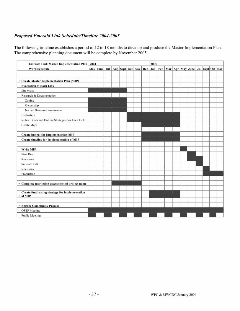
- 37 - WPC & MWCDC January 2004
Proposed Emerald Link Schedule/Timeline 2004-2005 The following timeline establishes a period of 12 to 18 months to develop and produce the Master Implementation Plan. The comprehensive planning document will be complete by November 2005.
Emerald Link Master Implementation Plan 2004 2005 Work Schedule May June Jul Aug Sept Oct Nov Dec Jan Feb Mar Apr May June Jul Sept Oct Nov
• Create Master Implementation Plan (MIP) Evaluation of Each Link Site visits Research & Documentation Zoning Ownership Natural Resource Assessment Evaluation Refine Goals and Outline Strategies for Each Link Create Maps Create budget for Implementation MIP Create timeline for Implementation of MIP Write MIP First Draft Revisions Second Draft Revisions Production • Complete marketing assessment of project name
• Create fundraising strategy for implementation of MIP
• Engage Community Process OSTF Meeting Public Meeting
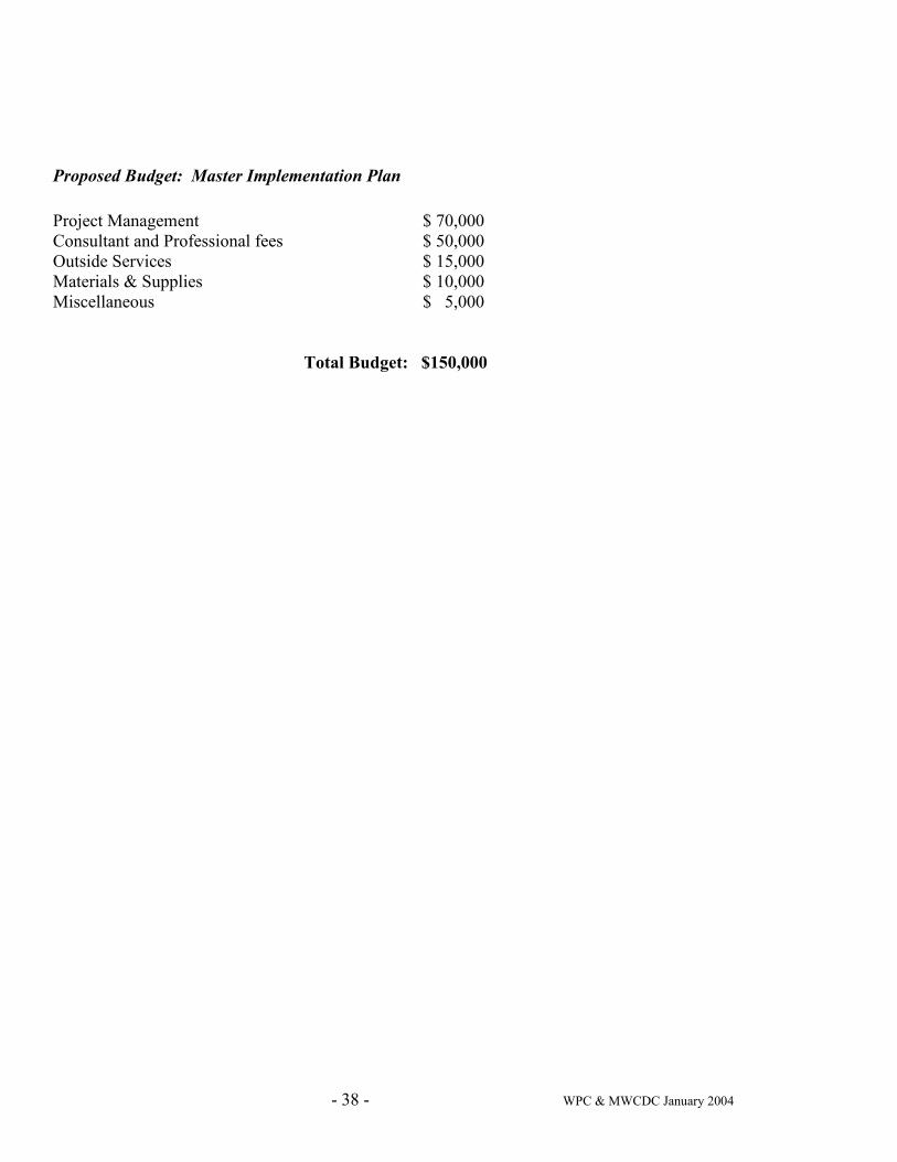
- 38 - WPC & MWCDC January 2004
Proposed Budget: Master Implementation Plan
Project Management $ 70,000 Consultant and Professional fees $ 50,000 Outside Services $ 15,000 Materials & Supplies $ 10,000 Miscellaneous $ 5,000
Total Budget: $150,000
- 39 - WPC & MWCDC January 2004
Appendix A
Emerald Link Project
MWCDC Public Process 10/1/03 through 1/12/04
The public process around the Emerald Link project has taken three forms:
1. Community Forums (public meetings with a focus on a particular topic)
2. Meetings of the Open Space Task Force, the MWCDC membership committee that focuses on open/green spaces and which has been chartered with the Emerald Link project; and
3. Newsletter articles in the monthly MWCDC newsletter View Point
A log of meetings follows (meeting agendas and summaries are available):
October 4, 2003: Open Space Task Force Meeting (MWCDC offices) Topics: Organizational structure for the Emerald Link project, representation on the Task Force for each Link, project schedule, mission statement, site selection criteria for anchor greening project, site identification for five potential anchor greening sites
October 16, 2003: MWCDC Annual Meeting (Duquesne Heights Community Center) Topics: Introduction of project consultant and announcement of community forum about Emerald Link scheduled for November 20th
November 20, 2003: MWCDC Public Meeting (Parkvale Bank) Topics: Overview of project purpose, scope, schedule, and participants; role of Open Space Task Force; preliminary schemes for anchor greening project
November 22, 2003: MWCDC Open Space Task Force (MWCDC offices) Topics: Project planning, project implementation, land protection, transportation projects (West End Circle and the Woodruff HOV tunnels), anchor greening project, final approval of mission statement
January 7, 2004: MWCDC Public Meeting (Mt. Washington Senior Center) Topic: Grandview Avenue
January 10, 2004: Open Space Task Force Meeting (MWCDC offices) Topics: Task Force membership, scope document, anchor greening project, public process
- 40 - WPC & MWCDC January 2004
Appendix B
EMERALD LINK
Project Contact List
Initial Project Participants
Western Pennsylvania Conservancy
Project Participant Western Pennsylvania Conservancy 209 Fourth Avenue Pittsburgh, PA 15222 Fax: 412-281-1792 Jean Grogan, Vice President, Community Conservation Program Phone: 412-586-2348 [email protected] Mark E. Wallace, Stewardship Director, Community Conservation Phone: 412-586-2394 [email protected]
Mt. Washington Community Development Corporation
Project Participant 301 Shiloh Street Pittsburgh, PA 15211 412-481-3220 (phone/fax) www.MWCDC.org Anthony (Jay) Molluso, Board President, [email protected] Wendy Powers, Executive Director, [email protected] Margaret McKinley, Chairperson, Open Space Task Force, [email protected] Tom Brady, Chairperson OSTF, [email protected] Susan E. Brandt
Former MWCDC Executive Director with knowledge and history of project One Trimont Lane #1600 A Pittsburgh PA 15211 412-488-0805 [email protected]
- 41 - WPC & MWCDC January 2004
Potential Project Resources
Allegheny Land Trust
Explore conservation opportunities for Emerald Link land Roy Kraynyk, Executive Director 1901 Glen Mitchell Road Sewickley, PA 15143-8856 412-749-4882/ fax 4883 [email protected] PA Cleanways
Partners with local community volunteers for clean up projects Allegheny County Chapter 120 North Shore Dr Pittsburgh, PA 15212 412-322-6681 www.pacleanways.org Riverlife Task Force
Nonprofit organization engaged in many initiatives that are complementary to the Emerald Link project Lisa Schroeder, Executive Director Regional Enterprise Tower 425 Sixth Ave Pittsburgh PA 15219 412-528-6636 email: [email protected] Student Conservation Association
Partners with community for trail building and conservation projects 239 4th Ave, Suite 1007 Pittsburgh PA 15222 412-325-1851 www.thesca.org
- 42 - WPC & MWCDC January 2004
West Pittsburgh Partnership
Providing support and community involvement for issues related to West End, including West End Circle project Dru Imler, Executive Director 37 Wabash Avenue Pittsburgh, PA 15220 412-922-2740/fax 3014 [email protected]
Consultants Valentina A. Vavasis
Contracted by project participants to complete project work and support community process 1505 Denniston Street Pittsburgh, PA 15217 412-421-1220 [email protected] Klavon Design Associates, Inc.
Landscape Architect, anchor greening project 915 Penn Avenue, Suite 1005 Pittsburgh, PA 15222 412-394-1181 Dina Cole Klavon, Principal, [email protected] Bohlin Cywinski Jackson
Completed many years of design work on Grandview Avenue and produced study adopted by City Bank Tower, 13th Floor Pittsburgh PA 15222 412-765-3890 Sarah Drake, [email protected]
Transportation Authorities Port Authority of Allegheny County
Owner of land in Emerald Link with transportation improvement projects underway Kirk L. Thomspon 345 Sixth Avenue, 3rd Floor Pittsburgh, PA 15222-2527 [email protected]
- 43 - WPC & MWCDC January 2004
Pennsylvania Department of Transportation
Owner of land in Emerald Link with transportation improvement projects underway Cheryl Moon-Sirianni Senior Project Manager 45 Thomas Blvd Pittsburgh PA 15017 412-429-4871 [email protected]
Government Agencies City of Pittsburgh Dwayne Ashley Dir of Parks & Recreation 412-255-2362 Mike Gable Public Works, head of parks maintenance 412-255-2488 Bob Reppe Planning commission 412-255-8996 Bill Wadell Real estate 412-255-2300 Susan Golomb Director, City Planning Dan Sentz City Planning Environmental contact 412-255-2233 Angelique Bamberg Staff to historic review commission;
knowledgeable about Grandview Park
Bruce Padoff Chief Architect, City Eng & Construction 412-255-2604 Sidney Kaikai Transp Planning, managing scenic byway project 412-255-2224 Pat Hassett Assit Planning Director 412-255-2234 Rich Belasario Asst Planning Director & CDBG Supervisor Public Officials Jack Wagner Senator 412-565-7974 Michael Diven State Representative 412-306-5905 Gene Ricciardi City Councilman 412-255-2130 Wayne Fontana City Councilman 412-350-6580 Alan Hertzberg City Councilman 412-255-8963 PA Department of Conservation and Natural Resources (DCNR)
Available to provide technical assistance and environmental project funding Kathey A. Frankel Bureau of Recreation and conservation 412 State Office Building 300 Liberty Ave. Pittsburgh PA 15222 412-565-7803
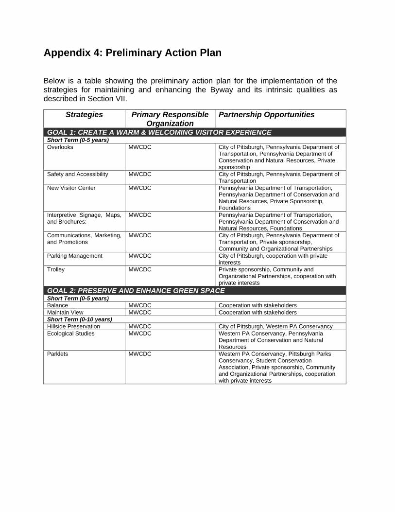
Appendix 4: Preliminary Action Plan Below is a table showing the preliminary action plan for the implementation of the strategies for maintaining and enhancing the Byway and its intrinsic qualities as described in Section VII.
Strategies Primary Responsible
Organization Partnership Opportunities
GOAL 1: CREATE A WARM & WELCOMING VISITOR EXPERIENCE Short Term (0-5 years) Overlooks MWCDC City of Pittsburgh, Pennsylvania Department of
Transportation, Pennsylvania Department of Conservation and Natural Resources, Private sponsorship
Safety and Accessibility MWCDC City of Pittsburgh, Pennsylvania Department of Transportation
New Visitor Center MWCDC Pennsylvania Department of Transportation, Pennsylvania Department of Conservation and Natural Resources, Private Sponsorship, Foundations
Interpretive Signage, Maps, and Brochures:
MWCDC Pennsylvania Department of Transportation, Pennsylvania Department of Conservation and Natural Resources, Foundations
Communications, Marketing, and Promotions
MWCDC City of Pittsburgh, Pennsylvania Department of Transportation, Private sponsorship, Community and Organizational Partnerships
Parking Management MWCDC City of Pittsburgh, cooperation with private interests
Trolley MWCDC Private sponsorship, Community and Organizational Partnerships, cooperation with private interests
GOAL 2: PRESERVE AND ENHANCE GREEN SPACE Short Term (0-5 years) Balance MWCDC Cooperation with stakeholders Maintain View MWCDC Cooperation with stakeholders Short Term (0-10 years) Hillside Preservation MWCDC City of Pittsburgh, Western PA Conservancy Ecological Studies MWCDC Western PA Conservancy, Pennsylvania
Department of Conservation and Natural Resources
Parklets MWCDC Western PA Conservancy, Pittsburgh Parks Conservancy, Student Conservation Association, Private sponsorship, Community and Organizational Partnerships, cooperation with private interests
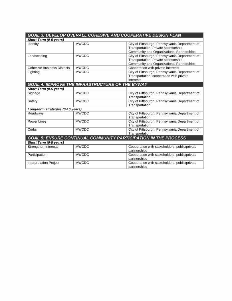
GOAL 3: DEVELOP OVERALL COHESIVE AND COOPERATIVE DESIGN PLAN Short Term (0-5 years) Identity MWCDC City of Pittsburgh, Pennsylvania Department of
Transportation, Private sponsorship, Community and Organizational Partnerships
Landscaping MWCDC City of Pittsburgh, Pennsylvania Department of Transportation, Private sponsorship, Community and Organizational Partnerships
Cohesive Business Districts MWCDC Cooperation with private interests Lighting MWCDC City of Pittsburgh, Pennsylvania Department of
Transportation, cooperation with private interests
GOAL 4: IMPROVE THE INFRASTRUCTURE OF THE BYWAY Short Term (0-5 years) Signage MWCDC City of Pittsburgh, Pennsylvania Department of
Transportation Safety MWCDC City of Pittsburgh, Pennsylvania Department of
Transportation Long-term strategies (0-10 years) Roadways MWCDC City of Pittsburgh, Pennsylvania Department of
Transportation Power Lines MWCDC City of Pittsburgh, Pennsylvania Department of
Transportation Curbs MWCDC City of Pittsburgh, Pennsylvania Department of
Transportation GOAL 5: ENSURE CONTINUAL COMMUNITY PARTICIPATION IN THE PROCESS Short Term (0-5 years) Strengthen Interests MWCDC Cooperation with stakeholders, public/private
partnerships Participation MWCDC Cooperation with stakeholders, public/private
partnerships Interpretation Project MWCDC Cooperation with stakeholders, public/private
partnerships

Appendix 5: Letters of Support