grand sable dunes research natural area · grand sable dunes research natural ... glacial history...
TRANSCRIPT

Grand Sable Dunes Research Natural Area
Where Can I See the Dunes? ThebestplacetoviewtheGrandSableDunesisfromthetrailthatbeginsatthewestendoftheSableFallsparkingarea.Thistrailleadsthroughanoldfield,thencrossesabridgeoverSableCreek.Itthenventuresintotheforestanddunestransitionareaforapproximately1/4mile.Waysideexhibitsarelocatedalongthetrail. AnotheraccesspointforthedunesisfromtheNorthCountryTrail1/4mileeastoftheLogSlide. Please stay on the trail in both of these areas as the dunes vegeta-tion is fragile.
Dunes Preserved as Research Area TheGrandSableDunesareamongthebestexamplesofpercheddunesystemsintheworld.AlargeportionofthedunesispreservedintheGrandSableDunesResearchNaturalArea(RNA).TheRNAwasdesignatedbytheLakeshorein1994.ResearchNaturalAreasarepartofanationalnetworkoffieldecologicalareasdesignatedforresearchandeduca-tionandtomaintainbiologicaldiversity.Theyaresetasidetoprovidescientistswithapermanenttractonwhichtherewillbeminimalinterferenceintheconductofneededresearch,inter-pretationwillbeprovidedprimarilyoff-site. TheGrandSableDunesResearchNaturalAreaislocated3.5mileswestofGrandMarais,Mich.,adja-centtoandnorthofAlgerCountyRoadH-58.Theresearchareacom-prises2.8squaremiles,themajorportionofanactivepercheddunefieldalongLakeSuperiorwithintheextremeeasternportionofPicturedRocksNationalLakeshore.TheRNAconsistsoftwounits;thewesternunitisapproximately1630acres,whiletheeasternunitisapproximately200acres. ThepercheddunefieldoftheRNAincludesareasofactivesanddeposition/deflationandinterdunalareasinvariousstagesofstabiliza-tion.Thedunessupportopen,sparseplantcommunitiesaswellaspatchesofjackpineforest.Plantsuccessionhasbeenperiodicallyinterruptedbysanddeposition/deflation.Border-ingthedunestothesouth,east,andwestissecondgrowthnorthernhardwoodforest.Native Americans The“GitcheeNagow”(GreatSands)figuredprominentlyinOjib-walegendandwerereportedlyatraditionalsiteoffastingstationswhichplayedakeyroleinreligiousceremoniesatimportantpointsin
Ojibwalife.Earlyaccountsof“lesGrandesSables”bylaketravellers,beginningwithRadissonandGro-seillersin1658,arewellknown.Noknownhistoricsites,perse,arepres-entintheRNA.
Climate TheGrandSableDuneshaveahumidcontinentalclimate.Wintersarelongandcold,andsummersareshortandcool;thegrowingseasonaverages107daysannually.ThedunesareinthesecondmostcloudyregionoftheUnitedStates,withanannualmeancloudcoverof70%.TheaverageannualtemperatureforGrandMaraisis40.8degreesF.Precipitationtotalsabout31inchesperyearwithmaximumamountsoccurringduringthesummer.About32%ofthearea’sprecipitationfallsassnow;totalaccumulationofsnowrangesfrom130to200+inches.TheproximityofLakeSuperiorpreventsextremelowtemperaturesinwinterandextremewarmtemperaturesinsummer.
Glacial History DuringthePleisto-ceneepoch,icesheetsofseveralNorthAmeri-canglacialstagesad-vancedandretreatedthroughthearea.ThefinalmajorstageoftheGreatLakeanglaciationcompleteditsadvancejustsoutheastoftheGreenBay,Wisc.,about11,500yearsago.Abriefre-advance,theMarquettesubstage,occurredabout10,000yearsagoinnorthernUpperMichigan. MeltingofglacialicewithintheSuperiorBasinproducedhugeriversthatdepositedmillionsof
tonsofpulverizedrockrubbleinvariousconfigurationstothesouthoftheSuperiorbasin.TheGrandSableBanksmayhaveoriginatedasaglaciofluvialkameterracealongaglacialriversduringdeglaciation. AsiceretreatedcompletelyfromtheSuperiorBasin,waterlevelsinthebasinrecededrapidlynorthwardleavingthePicturedRocksarea“highanddry”about9500yearago.Thisoccurredasoutletchannelstotheeastre-mainedatlowlevelsduetotherecentloadingofglacialice.NearthepresentsiteofGrandMarais,anorthfacingicecontactbluffandplatformsouthofitbecameforestedandremainedstablefor4500yearsafterdeglaciation. Between6,000and4,000yearsbeforepresent,reboundoftheearth’scrustfromits“depressed”statebegantoaccelerateaslandwasrelievedofthehugeweightoftheicesheets.TheriseoftheoutletofancestralLakeSuperioratNorth
Bay,Ontario,causedlakeleveltoriserelativelyquicklytoalevelabout40feethigherthanpresentLakeSupe-rior,formingglacialLakeNipissing. AslevelsofLakeNipissingrose,theGrandSableBanksweredestabi-lizedandformedanorthfacingac-tivecolluvialslope.Unconsolidated
Pictured Rocks National LakeshoreNational Park ServiceU.S. Department of the Interior
“Wild Beauty on the Lake Superior Shore”
sandonthisslopewasentrainedbypredominantnorthwesterlywindsanddepositedontheplateautoptoformtheGrandSableDunes. NopermanentlakesorstreamsoccurwithintheRNA.SeveralseepsandspringsissuefromthebaseoftheGrandSableBankswheregroundwaterisconcentratedbyanimpervioussedimentarylayer. Nosoilprofiledevelopmentcanbe
observedinmodernsurfacedeposits.Severalpaleosolsburiedatdifferenttimesoverthepast5,000yearsarepres-entandreflectpaleoecologicalcondi-tionsoverthattimeperiod.Mostarenotreadilyseenbythecasualobserver. Themostabundantlargemam-malsinthevicinityoftheRNAarethewhite-taileddeerandblackbear.AdeeryardislocatednortheastofGrandSableLakeandafewdeerusuallywinterinjackpinepatchesintheeasternportionofthedunes.Baldeaglesoarintheareaandcom-monharriersdriftovertheopenstretches. Dunegrass,LakeHurontansy,jackpine,andbalsampoplararecommoninthedunes.Moreuncom-monresidents(andprotectedbylaw)includePitcher’sThistle,grapeferns,andorchidsarefoundherealso.
Geomorphic Dynamism Researchhasshownthatlakelevelchanges,windandwavere-gimesaredriversofgeomorphicchangeandthatthischangehasinfluenceoncoastalvegetationpatterns.Manyrareorrelictplantcommunitiesandspeciesoccurinunusualhabitatswithinthecoastalzone.Fluctuatinglakelevelshavebuiltanddestroyedtimesynchro-nizedsitessomeofwhichhavebeenutilizedinstudiesofplantsuccessionandratesofsoilformation.Fromstudiesofplantassemblagesonthe
dunesithasbeensuggestedthatthefatesofseveralrarespeciesaretiedtospecificdisturbanceregimeswithinashiftinghabitatmosaic.Thesedemographiccharacteristicsofsmall,isolatedpopulationsinhighlydynamiclandscapepatchesarekeystospeciespersistenceovertime. Somepaleoecologicalworkhassuggestedthatlandscapedistur-banceregimeisalteredbyclimaticshiftsandspeciescompositioninacomplexway.Disturbanceregimesmayundergostep-likeshiftsthatcauserapidchangeinvegetationasclimatevariesgraduallyovertime.Thissuggestioniscentraltoques-tionsaboutlinkageofvegetationpatternsandclimate. ThathabitatsanddisturbanceregimesontheGrandSableDunesplateauhavechangeddrasticallyinthepastiswitnessedbythepresenceof“ghostforests”ofapparentvari-ousagewithinthedunefieldandcharcoalfragmentsassociatedwithseveralancientsoils. Studiesoffirehistory,rareplantdistribution,soils,forestecologyandgeomorphologyofthedunefieldandnorthernhardwoodandconiferforestssurroundingitsuggestthatmanydriversoflandscapedynamisminteractinthedunes.Thiscomplexinteractionproducesdistinctivepat-ternsofcommunitytypes,speciesrichness,andpatchturnoverwithinarelativelysmallarea.
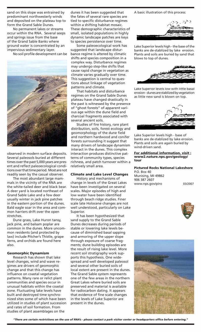
Climate and Lake Level Changes HistoryandmechanismsofchangeinlevelsoftheGreatLakeshavebeeninvestigatedonseveralscales.Majorepisodesofhighandlowwaterhavebeenidentifiedthroughbeachridgestudies.FinerscalelateHolocenechangesarenotwellunderstood,particularlyonLakeSuperior. IthasbeenhypothesizedthatsandsupplytotheGrandSableDunesdecreasesduringperiodsofstableorloweringlakelevelsbe-causeofdiminishedbasalsappingandarmoringoftheupperslopethroughexposureofcoarsefrag-ments;dunebuildingepisodesaretheresultofrisinglakelevel.Morerecentsoilstratigraphyworksup-portsthishypothesis.Onewide-spreadandwelldevelopedpaleosolandseveralotherburiedsoilsoflocalextentarepresentinthedunes.TheGrandSablesystemrepresentsoneofthefewareasinthenorthernGreatLakeswhereburiedsoilsarepreservedandmaterialisavailableforradiocarbondating.ItappearsthatevidenceoffinescalechangesinthelevelsofLakeSuperiorarepresentinthedunes.
“There are certain restrictions on the use of RNA’s - please contact a park visitor center or headquarters office before entering.”
LakeSuperiorlevelslowwithlittlebasalerosion-dunesarestablizedbyvegetationaslittlenewsandisblownontop.
LakeSuperiorlevelshigh-thebaseofthebanksarede-stablizedbylakeerosion.Plantsandsoilsareburiedbysandthatblowstotopofdunes.
LakeSuperiorlevelshigh-baseofbanksarede-stablizedbylakeerosion.Plantsandsoilsareagainburiedbywind-drivensand.
Abasicillustrationofthisprocess:
For additional information, visit :www2.nature.nps.gov/geology/tour
Pictured Rocks National LakeshoreP.O.Box40Munising,MI498629063872607www.nps.gov/piro03/2007