grafnav volcano monitoring · the usgs is able to monitor crater movement on mount st. helens with...
TRANSCRIPT

System ConfigurationTable 1:
GrafNav Volcano MonitoringNovAtel’s Waypoint GrafNav software post-processes data from the crater of Mt. St. Helens
The U.S. Geological Survey’s Cascades Volcano Observatory (CVO) helps keep people safe when living with volcanoes and related natural hazards such as earthquakes, landslides, and debris flows. Their work is primarily in the western United States but can be anywhere in the world. CVO assesses hazards before they occur by identifying and studying past hazardous events and provide warnings when volcanic crises are imminent. Investigating and reporting on hazardous events after they occur allows the CVO to improve their assessment and prediction skills, and to help develop new concepts of how volcanoes work.
The CVO also studies the impact of natural processes on our environment and hopes
Component DescriptionReceiver NovAtel OEM single frequencyAntenna Micropulse 1372Transceiver Microwave Data Systems 9810
900 MHz spread spectrumData Processing Engine
NovAtel’s Waypoint GrafNav software
Baseline Lengths
2 to 6 km
Operating Schedule
Store, forward and process 20 minutes of 10 s L1 data on 30 minute intervals
Spider measuring the rate of the lava dome extrusion using a NovAtel receiver at Crater, Mount St. Figure 1: Helens, WashingtonPhoto Credit: Dan Dzurisin, United States Geological Survey (USGS), April 19, 2005
to keep natural processes from becoming natural disasters through education.
This case study concentrates on their work with GPS systems to monitor deformations of active landslides and volcanoes at Mount St. Helens. See Figure 1 above.
Remote StationsOne of three field stations at Mount St. Helens volcano is located on the dome in the crater. Access to all three remote sites is gained by helicopter. A GPS antenna is mounted on a steel pipe. An instrument shelter houses the remaining field station components as well as a seismic station and a tilt meter. A single 20 watt solar panel provides power to the GPS system. See also
Figure 2 on Page 2. Table 1 below shows the system configuration.
Volcano Monitoring with GrafNav: Mount St. Helens, Washington
1
SummaryThe USGS is able to monitor crater movement on Mount St. Helens with the help of NovAtel’s Waypoint GrafNav software. GrafNav post-processes data from the remote, geologically-hazardous dome sites, allowing clear discrimination of sub-centimeter movements.
GrafNav has an easy to use graphical interface and utilizes NovAtel’s precise GNSS processing engine. This processing engine has undergone years of development effort and has been optimized to give the highest precision with the least amount of operator intervention.
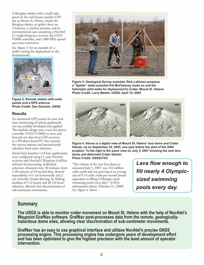
A fiberglass shelter with a small solar panel on the roof houses another GPS site at Mount St. Helens. Inside the fiberglass shelter, or spider, there are 2 batteries, a wireless antenna, and an environmental case containing a NovAtel L1 single-frequency receiver, the USGS V2000 controller, and a 900 MHz spread spectrum transceiver. See Figure 3 for an example of a spider waiting for deployment to the mountainside.
Figure 3: Geological Survey scientist, Rick LaHusen prepares a “Spider” while scientist Pat McChesney looks on and the helicopter pilot waits for deployment to Crater, Mount St. HelensPhoto Credit: Larry Mastin, USGS, April 14, 2005
Figure 2: Remote station with solar panels and a GPS antennaPhoto Credit: Dan Dzurisin, USGS
ResultsAn automated GPS system for near real-time monitoring of remote geohazards was successfully developed and applied. The modular design uses a new low-power controller (USGS V2000) to store and forward raw data from GPS receivers to a Windows-based PC that controls the remote stations and intermittently calculates fixed static solutions. Initial short baseline (<10 km) applications were configured using L1-only NovAtel receivers and NovAtel’s Waypoint GrafNav software for processing. Individual solutions, obtained every 30 minutes, from 5-20 minutes of 10-second data, showed repeatability of 1 cm horizontally and 2 cm vertically. Simple filtering, by finding medians of 5 (2 hours) and 48 (24 hour) solutions, allowed clear discrimination of sub-centimeter movements.
“The volume of the new lava dome as measured July 5, 2007, was 122 million cubic yards and was growing at an average rate of 0.14 cubic yards per second (nearly equivalent to filling 4 Olympic-sized swimming pools every day).” [USGS information release, February 21, 2008] See Figure 4 above.
Figure 4: Above is a digital view of Mount St. Helens’ lava dome and Crater Glacier, as on September 22, 2003, one year before the start of the 2004 eruption. To the right is the same view on July 5, 2007 showing the new lava dome and deformed Crater Glacier.Photo Credit: USGS/CVO
Lava flow enough to fill nearly 4 Olympic-sized swimming pools every day.
2