graduate thesis proposal earth sciences...
TRANSCRIPT

GRADUATE THESIS PROPOSAL
EARTH SCIENCES 6300
STUDENT NAME: Dawn Tobey
DEGREE PROGRAMME: MSc
SUPERVISOR: Martin Gibling
PROPOSAL TITLE:
An investigation of a vegetated fluvial-aeolian system: The Lower Cutler Beds of the Late Pennsylvanian to Early Permian Paradox Basin, Southeastern Utah.

2
SUMMARY OF PROPOSED RESEARCH:
The Valley of the Gods near Bluff, Utah, provides an unusual opportunity to study a Permo-Pennsylvanian fluvial system. Mesas and buttes within the valley have large vertical and horizontal expanses of outcrop with obvious fluvial channel margins. This study will focus on the distribution of fossilized plant remains in relation to associated fluvial deposits in order to interpret and reconstruct the Late Pennsylvanian to Early Permian landscape. Publications pertaining to the Permo-Pennsylvanian Lower Cutler Beds and Cedar Mesa Sandstone have focused on particular topics such as plant fossil remains and loess characterization. This study aims to integrate descriptions of fluvial depositional styles, plant fossil abundance, plant fossil locations, and aeolian depositional styles to create a landscape characterization model for the San Juan River area of the Paradox Basin, Utah.
Measured sections and photo mosaics will be created during two field seasons the first of which took place May, 2015. The size, shape, bedforms, and paleoflow of fluvial deposits have been recorded and will be analyzed using established frameworks. Paleobotanical information will be integrated with fluvial data to create a paleo-environmental reconstruction and depositional model for the area. Samples collected in the field will be analyzed with petrographic and scanning electron microscopes to establish the grain size distribution, mineralogy, and type of cement. Interpretations regarding the fluvial system, aridity, seasonality, and abundance of vegetation at the time of deposition will be based on the data gathered by these various techniques which, when combined, will contribute to the body of knowledge regarding arid Permian dryland fluvial systems as well as the interaction of plants and rivers in the Permian. TIMETABLE:

3
BUDGET:
EXPLANATION OF BUDGET: Field work:
Round trip airfare to Salt Lake City from Edmonton (year 1) and Halifax (year 2)
Food costs are based on per diem rates as set by Dalhousie University: max $48.00 per day for 18 days (year 1) and 21 days (year 2)
Car rental and gas costs for 18 days (year 1) and 21 days (year 2)
Accommodations for year 1 are based on shared accommodations with collaborating scientists from the Smithsonian Institute, Washington DC, and The Carnegie Natural History Museum Pittsburg, Pennsylvania while year 2 is based on single occupancy accommodations.
GSA 2015 Conference:
Round trip airfare to Baltimore from Halifax
Food costs based on per diem rates as set by Dalhousie University: Max $48.00 per day for 6 days, minus food provided at some conference events
Accommodations at downtown Baltimore hotel for 6 nights
Thin Sections: 44 thin sections prepared at Dalhousie University at $20.00 each Polished thin sections: 10 thin sections for SEM use, prepared at Dalhousie University at
$50.00 each SEM Lab time: Four hours per sample, for 10 samples at $20.00 per hour Miscellaneous lab costs: Software in the field, necessary field equipment, printing costs “IN-KIND” SUPPORT: None
PROPOSAL: Statement of Problem
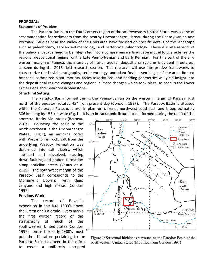
The Paradox Basin, in the Four Corners region of the southwestern United States was a zone of accommodation for sediments from the nearby Uncompahgre Plateau during the Pennsylvanian and Permian. Studies near the Valley of the Gods area have focused on specific details of the landscape such as paleobotany, aeolian sedimentology, and vertebrate paleontology. These discrete aspects of the paleo-landscape need to be integrated into a comprehensive landscape model to characterize the regional depositional regime for the Late Pennsylvanian and Early Permian. For this part of the arid western margin of Pangea, the interplay of fluvial- aeolian depositional systems is evident in outcrop, as seen during the 2015 field research season. This research will use interpretive frameworks to characterize the fluvial stratigraphy, sedimentology, and plant fossil assemblages of the area. Rooted horizons, carbonized plant imprints, facies associations, and bedding geometries will yield insight into the depositional regime changes and regional climate changes which took place, as seen in the Lower Cutler Beds and Cedar Mesa Sandstone. Structural Setting:
The Paradox Basin formed during the Pennsylvanian on the western margin of Pangea, just north of the equator, rotated 45° from present day (Condon, 1997). The Paradox Basin is situated within the Colorado Plateau, is oval in plan-form, trends northwest-southeast, and is approximately 306 km long by 153 km wide (Fig.1). It is an intracratonic flexural basin formed during the uplift of the ancestral Rocky Mountains (Barbeau 2003). Bounding the basin to the north-northeast is the Uncompahgre Plateau (Fig.1), an anticline cored with Precambrian rock. Salt from the underlying Paradox Formation was deformed into salt diapirs, which subsided and dissolved, causing down-faulting and graben formation along anticline crests (Venus et al 2015). The southwest margin of the Paradox Basin corresponds to the Monument Upwarp, with deep canyons and high mesas (Condon 1997). Previous Work:
The record of Powell’s expedition in the late 1800’s down the Green and Colorado Rivers marks the first written record of the stratigraphy of much of the southwestern United States (Condon 1997). Since the early 1900’s most published literature pertaining to the Paradox Basin has been in the effort to create a uniformly accepted
Figure 1: Structural highlands surrounding the Paradox Basin of the
southwestern United States (Modified from Condon 1997)

5
stratigraphic column. This has proven difficult, as the distal portion of the basin is highly variable and although several formal formation names have been assigned, they are not laterally continuous throughout the whole basin.
In 1997 Condon and the United States Geological Survey published a comprehensive overview of Pennsylvanian and Permian deposits which defined the Cutler Group as: 1) a lower Cutler unit comprising the former Elephant Canyon Formation, “Lower Cutler Beds”, Rico Formation, and Halgaito Tongue which is now collectively referred to as the Lower Cutler Beds (LCB) ; 2) the Cedar Mesa Sandstone; 3) the Organ Rock Formation; and 4) De Chelly Sandstone (Condon 1997). The northern, more proximal portion of the Paradox Basin is filled with heterogeneous, coarse-grained, sandstone to conglomeratic alluvial fan and braided river deposits. In this region, the Cutler Group cannot be subdivided due to its lack of unique identifying bed form or grading style, and is referred to as the Cutler Formation, undivided (Condon 1997). Unit names within this research are based on the nomenclature described by Condon (1997).
Current work within the Valley of the Gods area between Bluff and Mexican Hat is being carried out by scientists from the National Museum of Natural History, Smithsonian Institution, Department of Paleobiology; Illinois State Geological Survey, University of Illinois; and the Carnegie Museum of Natural History, Pittsburgh, Pennsylvania. This research covers paleobotany, regional mapping, and vertebrate paleontology respectively. Research herein is in collaboration with these scientists. Geologic Overview: Lower Cutler Beds (LCB): The LCB comprise all sediments between the underlying Hermosa Group and overlying Cedar Mesa Sandstone, including units formerly known as, and locally referred to as the Rico Formation and Halgaito Tongue (Fig.2)(Condon 1997). The lowermost portion of the LCB is a mix of quartzose sandstone with minor conglomerate, mudstone, siltstone, and marine limestone; the upper portion of the LCB is increasingly silty, predominantly very fine-grained silty sandstone and sandy siltstone, and almost uniformly brick red (Condon 1997). Limestone beds of the lower LCB grade northeast into terrestrial red beds, showing maximum extent of shoreline transgression (Condon 1997).
The upper and siltier portion of the Lower Cutler beds is interpreted as a more distal expression of aeolian deposits grading to the southwest
from aeolian Cedar Mesa Sandstone into loess (Fig. 3B) (Condon 1997). Loess is described as a windblown deposit of silt sized quartz grains in the range of 20-60 µm and a mode of 30 µm (Smalley 1995; Wright 2001). Due to global variations in grain sizes and mineralogy, Pye (1995) suggested that loess should be described as terrestrially derived windblown deposit of mainly silt sized grains. Cedar Mesa Sandstone: The Cedar Mesa Sandstone is a 304m thick, light- to yellow-grey, fine- to coarse-grained aeolian sandstone deposit that is thickest where the LCB are thinnest (Condon 1997). Rare siltstone and mudstone deposits interfinger with the fluvial-dominated Cutler Formation (undivided) to the northwest (Condon 1997). Four main facies were described by Langford and Chan (1989) including aeolian dunes, wet interdunes, fluvial channels, and overbank-interdunes. Dune
Figure 2:
Stratigraphic column
highlighting previous
(regional) and
modern
nomenclature as
determined by
Condon (1997)
(Modified from
DiMichele et al.
2014).

6
deposits comprise 90% of the formation, while wet interdune deposits, including limestone associated with mud cracks, rhizoliths, and gypsum crystal casts, make up 0-5% of the total deposit (Langford and Chan 1989). Although the authors claimed fluvial channels were only observed within the Cutler Formation (undivided), isolated channels have been documented in transitional zones with the Cedar Mesa Sandstone (DiMichele et al. 2014). Continuous sheets or discontinuous lenses of shale and sandstone formed in overbank-interdunes which grade laterally into aeolian sandstones and possible fluvial channel deposits comprise 5-10% of the Cedar Mesa Sandstone (Langford and Chan 1989). Objectives
This study will create a comprehensive landscape model integrating fluvial and aeolian sedimentology with paleobotany. Gibling and Davies (2012) showed the relationship between the evolution of plants and increasingly complex fluvial systems. This research will use the premise established therein to investigate the role Permo-Pennsylvanian vegetation played on the fluvial-aeolian LCB and Cedar Mesa Sandstone. This landscape model will be created by answering three questions, as follows:
1. What type of fluvial system dominated the landscape? a. What is the grain-size distribution? b. What facies associations are present? c. What architectural elements are present? d. What was the paleoflow?
2. What role did plants play on landscape evolution? a. What types of plant fossils are present? b. What is the relationship of plant fossils to the sediments they are found in? c. What is the abundance of fossilized root traces? d. What is the cyclicity of rooted horizons?
3. What was the interaction between fluvial and aeolian processes during the time of deposition? a. What types of bedforms are currently visible? b. What is the vertical sequence of bedforms? c. What is the dominant cement of the rocks? d. What was the timing of cementation in view of near surface loess consolidation?
The landscape model based on the results from these questions will be able to answer the following: 4. What was the climate and how did it change into the Early Permian? 5. What was the landscape like and how did it change from the deposition of the LCB to the Cedar
Mesa Sandstone? Data
Outcrop within the Valley of the Gods is exemplary with towering mesa and buttes with low-lying desert between them allowing for measurement of vertical sections and lateral correlations of beds. Most mesas and buttes comprise a lower slope-forming portion of LCB which grade upwards into bluff-forming Cedar Mesa Sandstone (Fig. 3D)(Condon 1997). Within the Paradox Basin, beds grade laterally into different beds or even different formations; logging vertical sections in different locations increases the confidence of lateral and vertical interpretations (Condon 1997). Rappelling down from the top of the outcrop, or scaling the vertical rock faces is not an option due to safety concerns.
Data for this project, in the form of field notes and samples, were collected during one field season in 2015. Three vertical sections have been recorded bed-by-bed with bedform, colour, and paleoflow measurements taken in the field. To aid in horizontal bed characterization, a series of

7
systematic photos were taken along strike, printed in a nearby town, and assembled into wide photo mosaics which were then attached to thick cardboard. In the field these photo mosaics were annotated with bedforms, channel margins, paleoflow azimuths and paleobotany sample locations. Methods Samples: Oriented field samples were taken opportunistically based on changes in important features such as lithology, grain size, or color to result in more significant data, from fewer samples, which can be examined in more detail given the time available. Thin sections have been made from all 44 samples and polished thin sections will be made as representative of their respective facies including loess, fluvial, lacustrine, and paleosol. Plant Fossils: The importance of plants on fluvial environments has been well established (Gibling and Davies 2012) and the skilled identification of these plants will provide quality data when interpreting floral assemblages (DiMichele et al. 2014). Plant fossil remains within the Lower Cutler Beds (Fig. 4A) and the Cedar Mesa Sandstone have been previously documented (DiMichele et al. 2014 and sources therein). Collaboration with the authors will provide an expert interpretation of plant fossil remains within the region. Known plant localities have been incorporated into field research locations to observe plant fossils in situ and discern their position relative to fluvial channels and bedforms. Paleoflow: Paleoflow measurements collected during the 2015 field season show shifting bedforms created by Permian rivers. Comparing rose diagrams for individual channels to rose diagrams for the entire research area highlights the degree of channel sinuosity and basin drainage direction, which can indicate sediment source direction (Miall 1974). Paleoflow rose diagrams will be weighted based on the scale of the bedform they represent; failing to do so skews resulting data by giving equal statistical weight to both a small ripple and a large dune, although the volume of sediment within a ripple is much smaller than a dune or troughed cross-bed (Miall 1974). Measurements in the field are taken by the same person with the same compass to increase precision.
Figure 3: A) A
Walchia branch.
B) 4m thick
sequence of loess
(1) incised by a
fluvial channel.
C) Well defined
channel (2)
incised into
paleosol (3) and
overlain by
several more
fluvial packages
(4). D) Two
buttes at one
measured section
(5). Original
channel form is
400m wide with
margin cut into
loess and
paleosols on the
west (left) end.

8
Fossilized Root Traces: Rooted plants are key to stabilizing fluvial channels, the presence of root systems within strata indicate flourishing flora during the time of deposition (Gibling and Davies 2012). Fossilized roots are commonly grouped in rooted horizons, however due diligence is needed when measuring vertical sections and tracing beds laterally to identify the horizon in which the roots originally grew as well as the depth of penetration. Fossilized root traces will be used as a proxy for floral abundance when there is a lack of preserved plant material. Calculations regarding roots will be basic total counts of roots per horizon, horizons within the section, and vertical spacing between horizons. Paleosols: Paleosols have been established as climatic indicators of increased humidity and rainfall in arid Permian and Quaternary sediments (Soreghan et al. 2002, Sun et al. 2006). Paleosols will yield insight into cyclicity of arid and humid periods during deposition of the LCB (Fig. 3C3). The mineralogy, grain size, soil fabrics, concretions, bioturbation, and ped and fracture surfaces will be investigated to identify the type of paleosol and its associated environment of deposition. Methods: Lab Techniques Petrographic Analysis Thin sections made from field samples will be assessed for grain type, size, and roundness; cementation style; and the presence of any sedimentary fabrics. Due to the abundance of silt within the LCB, samples are difficult to describe only using thin sections. Similar thin sections will be grouped into micro facies and representatives samples (10-12 in total) will be selected for further studied using a Scanning Electron Microscope (SEM). Scanning Electron Microscope (SEM) Saint Mary’s University’s (SMU) TESCAN MIRA 3 LMU Variable Pressure Schottky Field Emission Scanning Electron Microscope will be used to analyze polished representative thin sections, chosen through the examination of petrographic thin sections. The primary goal for using the SEM will be to produce high resolution images of highly magnified thin sections and to identify the composition of carbonate cements identified in thin section. The Energy Dispersive X-ray Spectroscopy (EDS) associated with the SEM will be used for mineralogical identification however if there is evidence of several carbonate mineral phases present in a given sample, it will become important to obtain precise geochemical information through the use of the Electron Microprobe in the Dalhousie University Earth Sciences department.
X-Ray Diffraction (XRD) will not be used for the analysis of samples, as the silt sized loess grains are large enough for the SEM to provide good geochemical data. Loess is typically described as silt sized particles of quartz from an aeolian source that lacks clay or other common minerals associated with fluvial deposits (Pye 1995) Abundant clay minerals have not been identified in thin section, however if large amounts of clay are observed using the SEM, the use of XRD will be reconsidered. Point Counts Thin sections will also be used for point counting at Saint Mary’s University Geology Department with the use of PETROG automated stepping stage and PetrogLit software mounted on a Nikon Eclipse E400 Pol petrographic microscope with a Pixe-Link digital camera. Point counting software and stepping stage will be used to systematically identify minerals and grain sizes to calculate averages and distributions. In accord with accepted protocols for point counting, 400-500 points will be
counted in order to obtain statistically relevant data. The accuracy and precision of this data will be of high confidence as the automated stepping stage removes possible human error derived from manually moving samples for point counts. Possible sources of error will be from misidentification of minerals, and the distinction of grains versus cement/matrix. Methods: Interpretive Frameworks The results from analyzing field notes and samples provide the answers to the first three objectives listed previously. These questions provide information regarding channel sinuosity; fluvial

9
flow direction; sediment source; floral abundance, and impact on the landscape; grain size distribution; and grain and cement mineralogy. Stratigraphic logs have been drafted from field notes for two of the three measured sections highlighting the fluvial, floodplain, aeolian, and lacustrine facies seen in the field. One measured section incorporates a vertebrate fossil bone bed, and a second has several instances of a Diplichnites cuithensis trackway (Chaney et al. 2013) and fossil plant remains (DiMichele et al. 2014). These answers can then be combined using two interpretive frameworks to synthesize a landscape characterization model to be able to answer the last two questions regarding landscape evolution and climate change during the Permo-Pennsylvanian. Fluvial Classification: Miall’s (2014) classification of a fluvial system relies on a hierarchy of sedimentological characteristics. At the smallest scale there are grain-to-grain relationships which determine the type of bedforms created (Fig. 4E). Bedforms are grouped into facies assemblages that define an architectural element (Fig. 4D). Channel fills comprise several architectural elements that define the morphology of the depositional fluvial system (Fig. 4C). Channel fills (Fig. 4B) are combined to form valley and basin fills (Fig. 4A). Field notes, photo mosaics, paleoflow measurements, grain size and mineralogy are combined for interpretations of figure 4 B, C, D, and E scales to establish the depositional system which created the LCB and Cedar Mesa Sandstone. Once the depositional system is known, paleobotanical data in the form of rooted horizons and preserved plant remains/impressions (Fig. 3A) are incorporated to create a thorough evaluation of the paleolandscape. Fluvial-Aeolian Systems: Fluvial-aeolian landscape characterization is categorized into six interactions between two different depositional systems based on sedimentary structures and bedforms, cementation styles, and vertical stacking of repeated packages (Langford 1989). These interactions were described by the examination of two modern locations (Langford 1989), then applied to several ancient deposits to test the viability of the classification system on ancient deposits (Langford and Chan 1989, Herries 1993). Herries (1993) utilised this classification system on the Cedar Mesa Sandstone within proximal regions of the Paradox Basin where the Cedar
Fig 4: Hierarchy of sedimentological features within Miall’s
classification of fluvial deposits: A) Valley and basin fills are
made of discrete or migrating channel fills [B]. B) Channel fills
comprise fluvial channels [C]. C) Fluvial channels are
characterised by their architectural elements [D]. D)
Architectural elements are groupings of facies associations [E].
E) Grain scale contacts and sedimentary bedforms create facies
classifications (From Miall 1996 in Miall 2014).

10
Mesa Sandstone inter-fingers with the Cutler Group (undivided). Loess within the LCB is often found associated with fluvial channels. Figure 3B shows an instance where a thick loess sequence has been incised into by the overlying fluvial channel. There are also many places where loess was found as the massive base in channel features (Fig 3C2) which becomes troughed and rippled near the top of the channel. As loess is similar to the interdune material described by Langford (1989) this method, coupled with the framework described by Miall (2014), will help build a robust characterization of the Permian Paradox Basin landscape to describe the interplay of loess and paleo-rivers. Significance
This study will produce a comprehensive landscape model, integrating sedimentological, mineralogical, and paleo-botanical data for an equatorial Permo-Pennsylvanian dryland fluvial system. This approach has not been applied to the research area; publications to date are on isolated topics with no contextual depositional system for the region. This research continues the work of Gibling and Davies (2012, and the sources therein) pertaining to the important coupling of vascular plant evolution with the increasing complexity of fluvial systems since the Cambrian. This review emphasized the role plants play on stabilizing fluvial landscapes and demonstrated the implications this information may have on modern landscapes where climate change has induced droughts and reduced habitable land. Vegetation has been shown to reduce erosion on riverbanks increasing stability during periods of peak water flow (Jansen and Nanson 2010; Gibling and Davies 2012).
The research proposed will influence publications in paleobotany, vertebrate paleontology, sedimentology, and stratigraphy by providing a landscape description including descriptions of fluvial styles, aeolian input to rivers, mineralogy, paleobotany, and the interactions between these varied disciplines. This integrated landscape model will also contribute to the body of knowledge pertaining to dryland fluvial systems on the western margin of Pangea during the Late Pennsylvanian and Early Permian. Western Pangea was undergoing major environmental changes during the Permian, with increased aridification and regional scale temperature increases. The regions with the most extreme climate changes were more hostile than anywhere on Earth today and the more moderate environments were comparable to the modern environments of Death Valley (Zambito and Benison 2013). The progressive aridification and drastic temperature increases are assumed to have led to decreased vegetation cover thus affecting the stability of channels, seen through a change of channel morphology to wider sandbed channels References: Baker, A.A., and Reeside, J.B.Jr, 1929. Bulletin AAPG, 13, 11, 1413-1418.; Barbeau, D. L., 2003. Basin Research, 15, 97-115.; Chaney, D. S., Lucas, S. G., Elrick, S., 2013. NM Museum of Nat Hist and Sci Bull., 60, 64-65.; Condon, S.M., 1997. USGS Bulletin 2000-P, 46.; DiMichele, W.A., Cecil, C.B., Chaney, D.S., et al., 2014. Utah Geo Assoc. Pub., 43, 491-504.; Gibling, M.R., and Davies, N.S., 2012. Nature Geo, 5, 99-105.; Herries, R.D., 1993. Geo. Soc. Special Pub, 73, 199-218.; Jansen, J.D., and Nanson, G.C. 2010. Jour. Geophys Research, 115 F04030, doi: 10.1029/2010JF001657.; Jordan, O.D., and Mountney, N.P., 2012. Jour of Sed Research, 82, 755-780.; Langford, R.P., 1989. Sedimentology, 36, 1023-1035.; Langford, R.P., and Chan, M.A., 1989. Sedimentology, 36, 1037-1051.; Miall, A.D. 2014. Fluvial Depositional Systems. 1-294.; Pye, K., 1995. Quat Sci Rev, 14, 653-667.; Smalley, I., 1995. Quat Sci Rev, 14, 645-651.; Soreghan, M.J., Soreghan, G.S., and Hamilton, M.A., 2002. Geology, 30, 695-698.; Sun, Y., Lu, H., and An, Z., 2006. Palaeogeo, Palaeoclim, Palaeoeco, 241, 129-138.; Venus, J.H., Mountney, N.P., and McCaffrey, W.D., 2015. Basin Research, 27, 152-182.; Wright, J.S., 2001, Geomorph, 36, 231-256.; Zambito, J. J., and Benison, K. C., 2013. Geology, 41, 587- 590.