grade 11 geography unit module 11. 3 oceanographyfode.education.gov.pg/courses/social science/grade...
TRANSCRIPT
GR 11 GEOGRAPHY UNIT MODULE 3
1
GRADE 11 GEOGRAPHY
UNIT MODULE 11. 3
OCEANOGRAPHY
11.3.1 Features of the World’s Oceans
11.3.2 Ownership and Control of Oceans and Marine
Resources
11.3.3 Use of Oceans
GR 11 GEOGRAPHY UNIT MODULE 1
2
Flexible Open and Distance Education Papua New Guinea
Published in 2017 @ Copyright 2017, Department of Education Papua New Guinea All rights reserved. No part of this publication may be reproduced, stored in a retrieval system, or transmitted in any form or by any means electronic, mechanical, photocopying, recording or any other form of reproduction by any process is allowed without the prior permission of the publisher. ISBN National Library Services of Papua New Guinea Compiled and finalised by: Social Science Department-FODE Printed by the Flexible, Open and Distance Education
ACKNOWLEDGEMENT
We acknowledge the contributions of all Secondary Teachers who in one way or
another have helped to develop this Course.
Our profound gratitude goes to the former Principal of FODE, Mr. Demas Tongogo
for leading FODE team towards this great achievement. Special thanks to the Staff of
the Social Science Department of FODE who played an active role in coordinating
writing workshops, outsourcing lesson writing and editing processes, involving
selected teachers of Central Province and NCD.
We also acknowledge the professional guidance provided by Curriculum and
Development Assessment Division throughout the processes of writing, and the
services given by member of the Social Science Review and Academic Committees.
The development of this book was Co-funded by GoPNG and World Bank.
DIANA TEIT AKIS
PRINCIPAL
GR 11 GEOGRAPHY UNIT MODULE 3
3
CONTENTS
Content ……………………………………………………………………………………………………………………………….. 3
Secretary’s Message…………………………………………………………………………………………………………….. 4
Course Introduction……………………………………………………………………………………………………………… 5
Study Guide …………………………………………………………………………………………………………………………. 6
Unit Introduction…………………………………………………………………………………………………………………. 7
11.3.1 FEATURES OF WORLD’S OCEANS
11.3.1.1 Where are the World’s Oceans?....................................................................... 9
11.3.1.2 Zones of Oceans…………………………………………………………………………………………… 13
11.3.1.3 Physical Landforms in the oceans…………………………………………………………………. 17
11.3.1.4 Ocean Current and their Influence on the Climate……………………………………….. 23
11.3.1.5 Marine Resources and their Ecosystem………………………………………………………… 29
11.3.2 OWNERSHIP AND CONTROL OF OCEANS AND MARINE RESOURCES
11.3.2.1 Ocean/Sea Floor……………………………………………………………………………………………
11.3.2.2 International Treaties/ Agreement and Organisation……………………………………
11.3.2.3 Indigenous rights to Seas and Resources………………………………………………………
37
41
46
11.3.3 USE OF OCEANS
11.3.3.1 Fishing Method and their Sustainability………………………………………………………..
11.3.3.2 Impact of Waste Disposal on Oceans……………………………………………………………
11.3.3.3 Impart of Oil and Mineral Exploration of the Ocean Floor…………………………….
11.3.3.4 Effects of Shipping on the Oceans…………………………………………………………………
11.3.3.5 Impact of Tourism on Coastal Regions and Islands……………………………………….
11.3.3.6 Causes and Effects of Depleting Ocean resource………………………………………….
50
58
61
65
71
73
Summary……………………………………………………………………………………………………………………………..
Answers to Learning Activities…………………………………………………………………………….................
References................................................................................................................................
75
76
84
GR 11 GEOGRAPHY UNIT MODULE 1
4
SECRETARY’S MESSAGE
Achieving a better future by individuals, students, their families, communities or the nation as a whole, depends on the curriculum and the way it is delivered.
This course is a part of the new Flexible, Open and Distance Education curriculum. The learning outcomes are student-centred and allows for them to be demonstrated and assessed.
It maintains the rationale, goals, aims and principles of the National OBE Curriculum and identifies the knowledge, skills, attitudes and values that students should achieve.
This is a provision of Flexible, Open and Distance Education as an alternative pathway of formal education.
The Course promotes Papua New Guinea values and beliefs which are found in our constitution, Government policies and reports. It is developed in line with the National Education Plan (2005 – 2014) and addresses an increase in the number of school leavers which has been coupled with a limited access to secondary and higher educational institutions.
Flexible, Open and Distance Education is guided by the Department of Education’s Mission which is fivefold;
to facilitate and promote integral development of every individual
to develop and encourage an education system which satisfies the requirements of Papua New Guinea and its people
to establish, preserve, and improve standards of education throughout Papua New Guinea
to make the benefits of such education available as widely as possible to all of the people
to make education accessible to the physically, mentally and socially handicapped as well as to those who are educationally disadvantaged
The College is enhanced to provide alternative and comparable path ways for students and adults to complete their education, through one system, many path ways and same learning outcomes.
It is our vision that Papua New Guineans harness all appropriate and affordable technologies to pursue this program.
I commend all those teachers, curriculum writers and instructional designers, who have contributed so much in developing this course.
DR. UKE KOMBRA Secretary for Education
GR 11 GEOGRAPHY UNIT MODULE 3
5
Dear Student, Welcome to the Grade 11 Geography Course. This COURSE consists of four unit modules: UNIT MODULE 1 : THE STRUCTURE OF THE EARTH UNIT MODULE 2 : NATURAL PROCESSES AND DISASTERS UNIT MODULE 3 : OCEANOGRAPHY UNIT MODULE 4 : POPULATION STUDIES The Grade 11 Geography Course is a follow up from what students have studied in Grade 10. It has been designed using learning outcomes that identify the knowledge, skills, attitude and values that all students achieve or demonstrate by the end of Grade 12.Grade 11 Geography course comprises of four modules.
11.1 : THE STRUCTURE OF THE EARTH
11.2 : NATURAL PROCESSES AND DISASTERS
11.3 : OCEANOGRAPHY
11.4 : POPULATION STUDIES
Assessments
Activities Each Unit Module has activities for you to do. Answers to the activities will be found at the end of each Unit after the Unit Summary
Assignments Each Unit has an Assignment which you will do and then send to FODE Provincial
Center for marking. The marked Assignment will be returned to you with comments and advice from your tutor. A mark will be given which will be counted towards your final internal mark.
Examinations After the completion of the course, you will sit for an internal exam which will make up 70 % of your total internal mark. You will now be ready for the Grade 12 National Examination which is held in October each year.
For more information refer to the Study Guide.
GR 11 GEOGRAPHY UNIT MODULE 1
6
STUDY GUIDE Below are the steps to guide you in your course study. Step 1: Carefully read through each module. In most cases, reading through a lesson
once is not enough. It helps to read something over several times until you understand it.
Step 2: There is an instruction below each activity that tells you to check your answers. Turn to the marking guide found at the end of each module and mark your own written answers against those listed under the Answers to Activities. Do each activity and mark your answers before moving on to the next part of the module.
Step 3: After reading the summary of the unit module, start doing the Practice Exercise. Refer to the module notes. You must do only one practice exercise at a time.
Step 4: Below each Learning activity, there is an instruction that says:
Turn to the marking guide at the end of the Module Unit and mark your own written answers against those listed under the Answers to Learning Activity.
Step 5: When you have completed a practice exercise and marked your answers, go back to the module and correct any mistakes you may have made before moving on to the next module.
Step 6: Study the entire module following Steps 1, 2, 3, 4 and 5. Here is a sample Study Timetable for you to use as a guide. Refer to it as a reminder of your study times.
TIME MON TUE WED THU FRI
8:00-10:00 F O D E S T U D Y
10:00-11:00
1:00-2:00
2:00-4:00
6:00-7:00
7:00-9:00 Listen to or watch current affairs programs. Write your diary or read a book.
A timetable will help you to remember when you should be doing your FODE studies each day.
CHECK YOUR WORK. ANSWERS ARE AT THE END OF COURSE MODULE 1.
GR 11 GEOGRAPHY UNIT MODULE 3
7
UNIT MODULE 11.3: OCEANOGRAPHY
INTRODUCTION Welcome to this Unit module on Oceanography. It is the third Unit Module in your Grade 11 Geography Course. There are three Topics in this Unit Module: Topic 1: Features of the World’s Oceans Topic 2: Ownership and control of Oceans and Marine Resources Topic 3: Use of Oceans Each topic is made up of sub-headings and learning activities. Throughout this course you will find the lessons and activities all correspond to the Theme Sustainable Resource Use and Management of the Marine Ecosystem. Through the learning activities we hope that you grasp the concept of the use of oceans and their importance to man.
Objectives or Aims
On successful completion of this module, you will be able to: 1. observe that oceans make up about 70 per cent of the earth’s surface
and that Papua New Guinea is located in the Pacific Ocean, the largest ocean in the world.
2. demonstrate an understanding that oceans have many ecosystems and provide many resources that sustains human life directly and indirectly.
3. identify and explain that oceans help regulate atmospheric cycles that are essential for life on earth.
4. appreciate the importance of oceans to life and address issues related to ownership and care of the ocean as a resource.
Time Frame This unit should be completed within 10 weeks. If you set an average of 3 hours per day, you should be able to complete the unit comfortably by the end of the assigned week. Try to do all the learning activities and compare your answers with the ones provided at the end of the unit. If you do not get a particular exercise right in the first attempt, you should not get discouraged but instead, go back and attempt it again. If you still do not get it right after several attempts then you should seek help from your friend or even your tutor. Do not pass any question without solving it first.
GR 11 GEOGRAPHY UNIT MODULE 1
8
TOPIC 11.3.1: FEATURES OF THE WORLD’S OCEANS
INTRODUCTION Welcome to Topic 1 Features of the World’s Oceans. This topic contains five lessons and five learning activities.
Objectives or Aims On completion of this topic you will be able to:
1. describe the physical features and influences of oceans around the world.
2. demonstrate an understanding of the importance of the ocean as a resource.
3. outline the economic and social importance and ownership of the sea areas and resources.
4. describe and compare marine systems. 5. interpret and create maps and diagrams that illustrate aspects of
oceanography. 6. investigate and explain issues relating to the use of oceans.
This topic should be completed within (4 ) weeks. If you set an average of 3 hours per day, you should be able to complete the unit comfortably by the end of the assigned week. Try to do all the learning activities and compare your answers with the ones provided at the end of the unit. If you do not get a particular exercise right in the first attempt, you should not get discouraged but instead, go back and attempt it again. If you still do not get it right after several attempts then you should seek help from your friend or even your tutor. Do not pass any question without solving it first.
GR 11 GEOGRAPHY UNIT MODULE 3
9
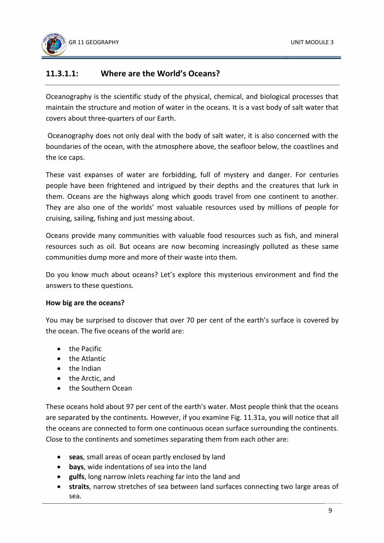
11.3.1.1: Where are the World’s Oceans?
Oceanography is the scientific study of the physical, chemical, and biological processes that
maintain the structure and motion of water in the oceans. It is a vast body of salt water that
covers about three-quarters of our Earth.
Oceanography does not only deal with the body of salt water, it is also concerned with the
boundaries of the ocean, with the atmosphere above, the seafloor below, the coastlines and
the ice caps.
These vast expanses of water are forbidding, full of mystery and danger. For centuries
people have been frightened and intrigued by their depths and the creatures that lurk in
them. Oceans are the highways along which goods travel from one continent to another.
They are also one of the worlds’ most valuable resources used by millions of people for
cruising, sailing, fishing and just messing about.
Oceans provide many communities with valuable food resources such as fish, and mineral
resources such as oil. But oceans are now becoming increasingly polluted as these same
communities dump more and more of their waste into them.
Do you know much about oceans? Let’s explore this mysterious environment and find the
answers to these questions.
How big are the oceans?
You may be surprised to discover that over 70 per cent of the earth’s surface is covered by
the ocean. The five oceans of the world are:
the Pacific
the Atlantic
the Indian
the Arctic, and
the Southern Ocean
These oceans hold about 97 per cent of the earth’s water. Most people think that the oceans
are separated by the continents. However, if you examine Fig. 11.31a, you will notice that all
the oceans are connected to form one continuous ocean surface surrounding the continents.
Close to the continents and sometimes separating them from each other are:
seas, small areas of ocean partly enclosed by land
bays, wide indentations of sea into the land
gulfs, long narrow inlets reaching far into the land and
straits, narrow stretches of sea between land surfaces connecting two large areas of sea.
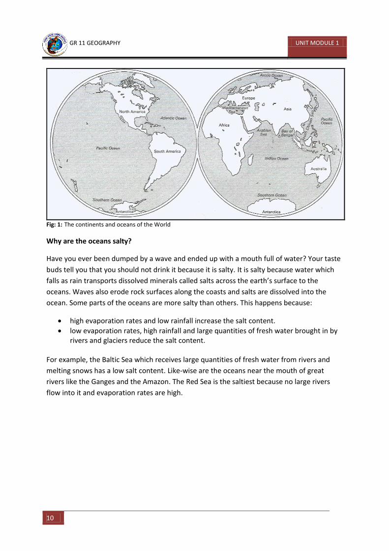
GR 11 GEOGRAPHY UNIT MODULE 1
10
Fig: 1: The continents and oceans of the World
Why are the oceans salty?
Have you ever been dumped by a wave and ended up with a mouth full of water? Your taste
buds tell you that you should not drink it because it is salty. It is salty because water which
falls as rain transports dissolved minerals called salts across the earth’s surface to the
oceans. Waves also erode rock surfaces along the coasts and salts are dissolved into the
ocean. Some parts of the oceans are more salty than others. This happens because:
high evaporation rates and low rainfall increase the salt content.
low evaporation rates, high rainfall and large quantities of fresh water brought in by rivers and glaciers reduce the salt content.
For example, the Baltic Sea which receives large quantities of fresh water from rivers and
melting snows has a low salt content. Like-wise are the oceans near the mouth of great
rivers like the Ganges and the Amazon. The Red Sea is the saltiest because no large rivers
flow into it and evaporation rates are high.
GR 11 GEOGRAPHY UNIT MODULE 3
11
Learning Activity 1
Study Fig 2 on page 12 to answer these questions. You will also need an atlas to do this.
1. Name the continents marked : a. ______________________ b. ______________________ c. ______________________ d. ______________________
e. ______________________ f. ______________________
2. Name the oceans marked: A. ______________________ B. ______________________ C. ______________________
D. ______________________
3. Name the seas marked:
E. _____________________ F. _____________________ G. _____________________ H. _____________________ I. _____________________ J. _____________________
K. _____________________ L. _____________________ M. _____________________ N. _____________________ O. _____________________
4. Name the bays marked:
P. ___________________ Q. ___________________ R. ___________________
5. Name the gulfs marked:
S. ___________________ T. ___________________
U. ___________________ V. ___________________
6. Name the straits marked:
W. ___________________ X. ___________________ Y. ___________________ Z. ___________________
GR 11 GEOGRAPHY UNIT MODULE 1
12
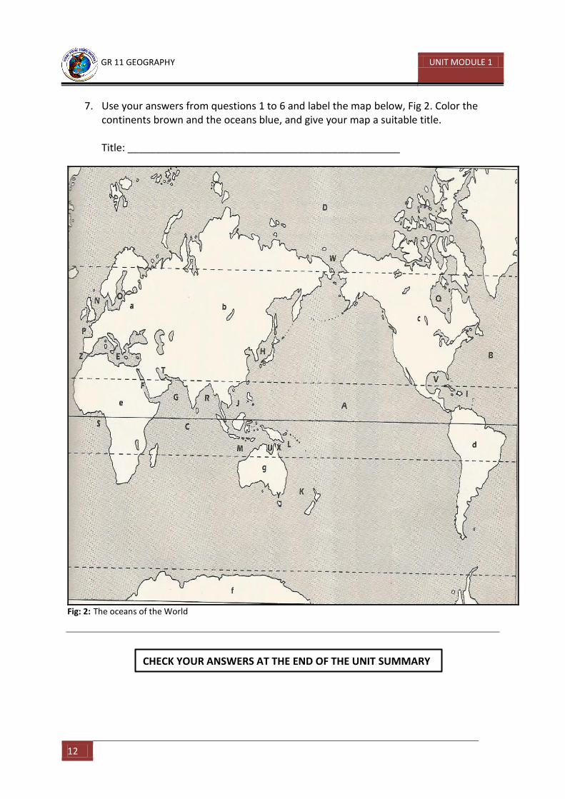
7. Use your answers from questions 1 to 6 and label the map below, Fig 2. Color the continents brown and the oceans blue, and give your map a suitable title. Title: ________________________________________________
Fig: 2: The oceans of the World
CHECK YOUR ANSWERS AT THE END OF THE UNIT SUMMARY
GR 11 GEOGRAPHY UNIT MODULE 3
13
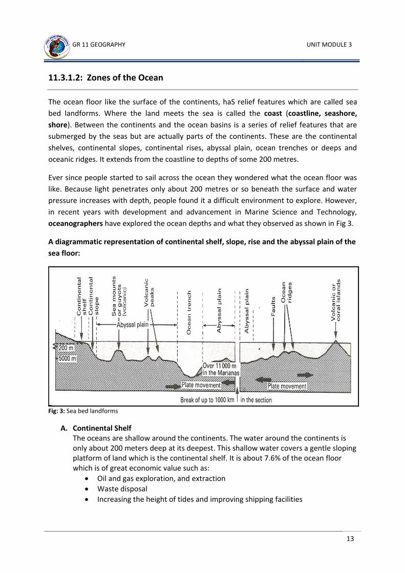
11.3.1.2: Zones of the Ocean
The ocean floor like the surface of the continents, haS relief features which are called sea
bed landforms. Where the land meets the sea is called the coast (coastline, seashore,
shore). Between the continents and the ocean basins is a series of relief features that are
submerged by the seas but are actually parts of the continents. These are the continental
shelves, continental slopes, continental rises, abyssal plain, ocean trenches or deeps and
oceanic ridges. It extends from the coastline to depths of some 200 metres.
Ever since people started to sail across the ocean they wondered what the ocean floor was
like. Because light penetrates only about 200 metres or so beneath the surface and water
pressure increases with depth, people found it a difficult environment to explore. However,
in recent years with development and advancement in Marine Science and Technology,
oceanographers have explored the ocean depths and what they observed as shown in Fig 3.
A diagrammatic representation of continental shelf, slope, rise and the abyssal plain of the
sea floor:
Fig: 3: Sea bed landforms
A. Continental Shelf The oceans are shallow around the continents. The water around the continents is only about 200 meters deep at its deepest. This shallow water covers a gentle sloping platform of land which is the continental shelf. It is about 7.6% of the ocean floor which is of great economic value such as:
Oil and gas exploration, and extraction
Waste disposal
Increasing the height of tides and improving shipping facilities
GR 11 GEOGRAPHY UNIT MODULE 1
14
Sunlight penetrating the sea on continental shelves, and therefore there is an abundance of plankton or small green marine plants resulting in an abundance of fish for commercial fishing activities.
Most of the fish we eat come from the shallow waters of the continental shelf. The shallow
water makes it possible for sunlight to penetrate all the way to the bottom. Nutrients are
supplied by erosion of the land and the shelves support an abundant marine food chain.
B. Continental Slope Where the continental shelf ends, is a steep slope known as the continental slope. It plunges downward like a cliff to a depth of about 3000 meters then it becomes less steep and finally levels out to a depth of about 4000 meters. Water and mud flowing from rivers on land have carved deep valleys in the continental slope with continuous sliding and slumping of marine sediments.
C. Continental Rise Below the continental slopes are the collection of sediments washed from the land and deposited in deep water. From the foot of the continental slopes down to the deep ocean floor are the continental rises that are gentle sloping.
D. Abyssal Plain It stretches from the base of the continental rise at depths of 4000 meters or more are the deep ocean floor which is called the abyssal plain or the abyss. It is covered with a thick layer of slimy mud known as abyssal deposits such as red clay.
Temperature here does not exceed 4C. The abyss is dark and cold because sunlight cannot reach these great depths and because the water hardly moves.
E. Oceanic Ridges Ocean Ridges are formed above the surface of the ocean floor as volcanic islands during plate movements, especially around spreading boundaries.
F. Ocean Trenches or Deeps These are found below the ocean floor and are created during plate collision. They are the deepest parts of the ocean basins of the world.
GR 11 GEOGRAPHY UNIT MODULE 3
15
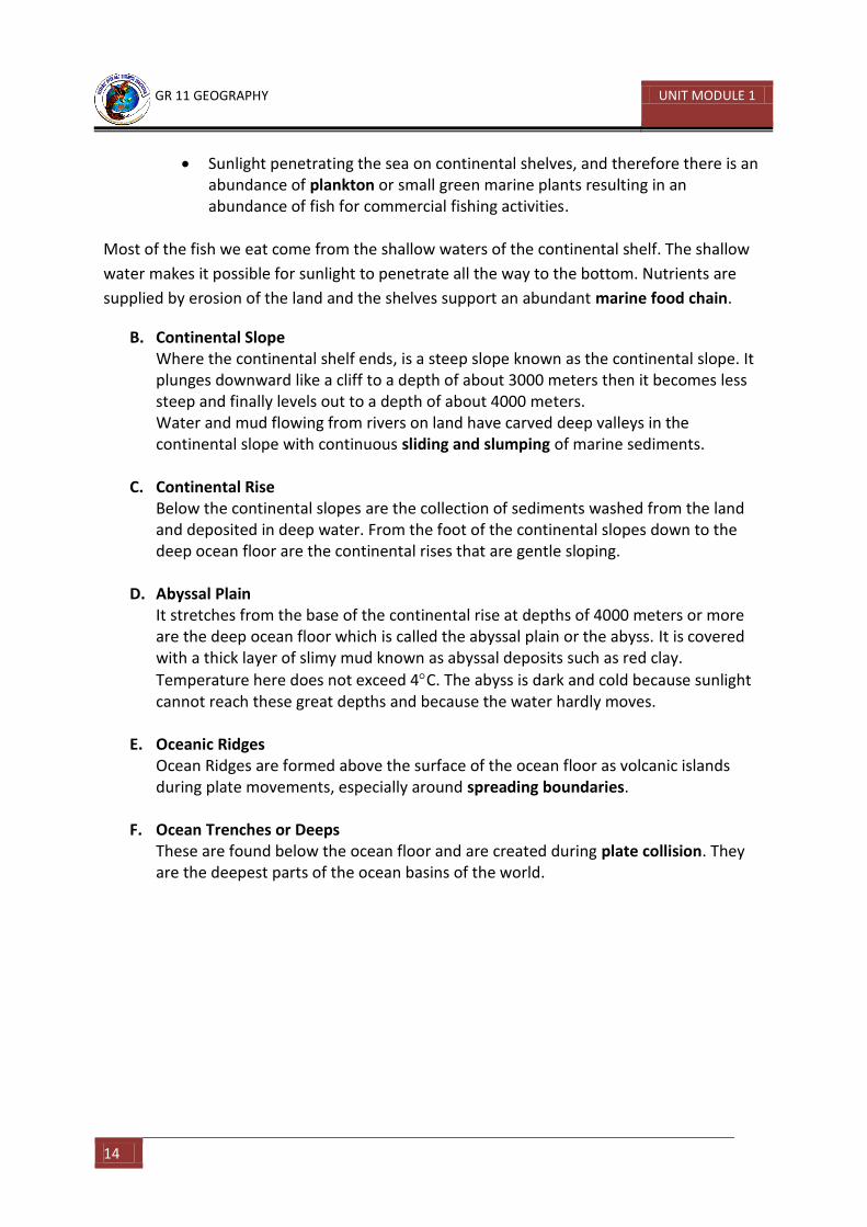
What lies beneath the ocean
Source: Physical Geography in Diagrams, R.B. Bunnet
Fig: 4: Nature of the ocean floor
GR 11 GEOGRAPHY UNIT MODULE 1
16
Learning Activity 2
1. Why is the ocean a difficult environment for people to explore?
_____________________________________________________________________
2. What is an oceanographer? _____________________________________________________________________
3. In which ocean are the deepest trenches located? _____________________________________________________________________
4. Which trench is the deepest and how many meters deep is it? _____________________________________________________________________
5. The mid-Atlantic Ridge runs through the Atlantic Ocean from north to south. It is surrounded by four continents. What are they? __________________________________________________________________________________________________________________________________________
6. What is the highest mountain on the land surface? How many meters high is it and in which country is it located? ____________________________________________________________________________
7. Explain the economic importance of the continental shelf? __________________________________________________________________________________________________________________________________________
8. List the seabed landforms. __________________________________________________________________________________________________________________________________________
9. How are they formed? __________________________________________________________________________________________________________________________________________
10. Draw a cross-section of the seabed landforms and correctly label it with the correct relief features? __________________________________________________________________________________________________________________________________________ __________________________________________________________________________________________________________________________________________
CHECK YOUR ANSWERS AT THE END OF THE UNIT SUMMARY
GR 11 GEOGRAPHY UNIT MODULE 3
17
11.3.1.3: The Physical Landforms in the Oceans
For hundreds of years scientists have observed the shape of the Earth and tried to explain
what they see, the mountains, the valleys and so on. Until very recently no single theory was
able to explain satisfactorily most of these features but over the last 50 years or so, more
and more evidence has supported the idea known as plate tectonics. Scientists had known
for a long time that the Earth consisted of different layers and that the Earth’s crust was only
a thin layer “floating” on denser liquid rocks beneath. What was missing was an explanation
of the actual shape of the crust and the movements that take place.
Theory of Plate Tectonics:
In 1968 W.J. Morgan put forward the idea that the earth’s crust is made up of a number of
rigid plates which move slowly in various directions. This is known as the Theory of Plate
Tectonics. These plates are of different sizes and they move around slowly in various
directions from each other. The surface of the plate may be continent, or continent and
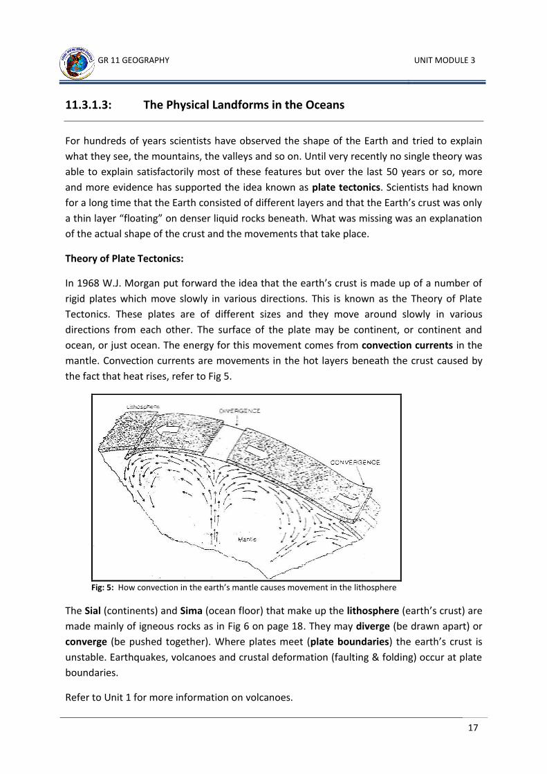
ocean, or just ocean. The energy for this movement comes from convection currents in the
mantle. Convection currents are movements in the hot layers beneath the crust caused by
the fact that heat rises, refer to Fig 5.
Fig: 5: How convection in the earth’s mantle causes movement in the lithosphere
The Sial (continents) and Sima (ocean floor) that make up the lithosphere (earth’s crust) are
made mainly of igneous rocks as in Fig 6 on page 18. They may diverge (be drawn apart) or
converge (be pushed together). Where plates meet (plate boundaries) the earth’s crust is
unstable. Earthquakes, volcanoes and crustal deformation (faulting & folding) occur at plate
boundaries.
Refer to Unit 1 for more information on volcanoes.
GR 11 GEOGRAPHY UNIT MODULE 1
18
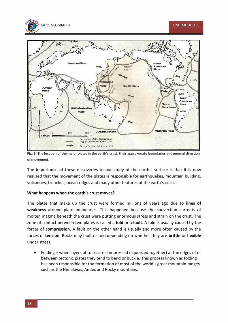
Fig: 6: The location of the major plates in the earth’s crust, their approximate boundaries and general direction
of movement.
The importance of these discoveries to our study of the earths’ surface is that it is now
realized that the movement of the plates is responsible for earthquakes, mountain building,
volcanoes, trenches, ocean ridges and many other features of the earth’s crust.
What happens when the earth’s crust moves?
The plates that make up the crust were formed millions of years ago due to lines of
weakness around plate boundaries. This happened because the convection currents of
molten magma beneath the crust were putting enormous stress and strain on the crust. The
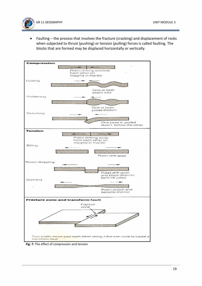
zone of contact between two plates is called a fold or a fault. A fold is usually caused by the
forces of compression. A fault on the other hand is usually and more often caused by the
forces of tension. Rocks may fault or fold depending on whether they are brittle or flexible
under stress.
Folding – when layers of rocks are compressed (squeezed together) at the edges of or between tectonic plates they tend to bend or buckle. This process known as folding has been responsible for the formation of most of the world’s great mountain ranges such as the Himalayas, Andes and Rocky mountains.
GR 11 GEOGRAPHY UNIT MODULE 3
19
Faulting – the process that involves the fracture (cracking) and displacement of rocks when subjected to thrust (pushing) or tension (pulling) forces is called faulting. The blocks that are formed may be displaced horizontally or vertically.
Fig: 7: The effect of compression and tension
GR 11 GEOGRAPHY UNIT MODULE 1
20
The direction in which the plates move determine the types of landforms that are created. When plates move they may:
collide or converge with each other and the edges of the plates are compressed.
move apart or diverge so that the boundaries of the plates are stretched or
tensioned, causing thinning or rifting of the earth’s crust.
slide pass each other along a fracture zone, a zone where the earth’s crust has a
distinct fault or break.
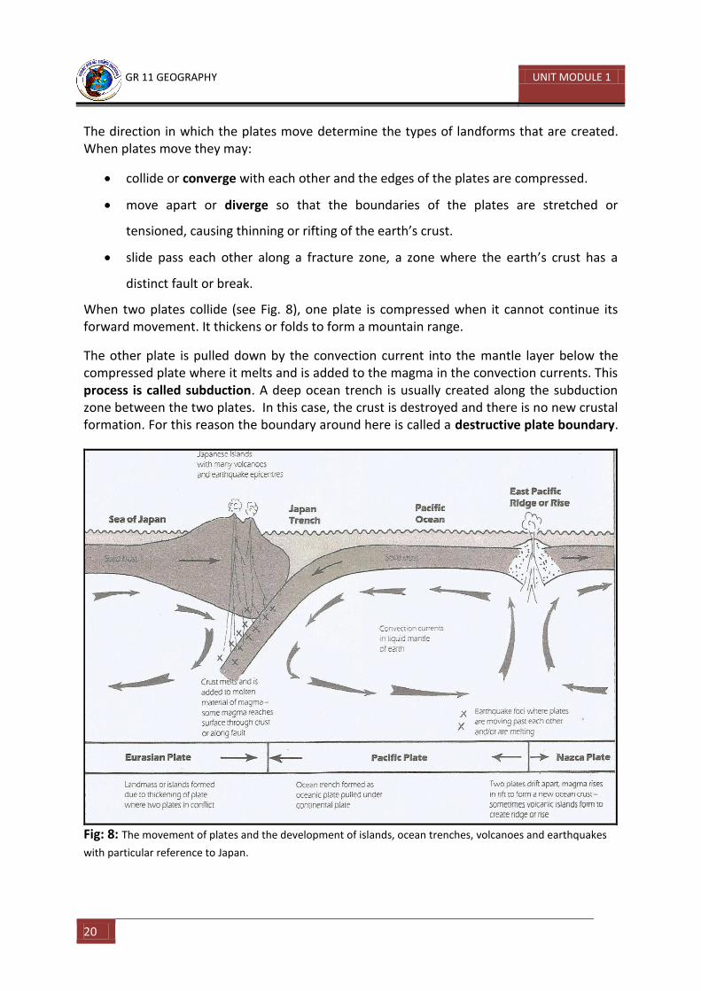
When two plates collide (see Fig. 8), one plate is compressed when it cannot continue its forward movement. It thickens or folds to form a mountain range.
The other plate is pulled down by the convection current into the mantle layer below the compressed plate where it melts and is added to the magma in the convection currents. This process is called subduction. A deep ocean trench is usually created along the subduction zone between the two plates. In this case, the crust is destroyed and there is no new crustal formation. For this reason the boundary around here is called a destructive plate boundary.
Fig: 8: The movement of plates and the development of islands, ocean trenches, volcanoes and earthquakes
with particular reference to Japan.
GR 11 GEOGRAPHY UNIT MODULE 3
21
When two plates are drifting apart the crust is stretching or thinning along the line of
weakness. This allows magma in the mantle to escape from beneath the Earth’s crust. On
the ocean floor the magma forms a new layer of crust which is added to the plates as they
move apart. This process on the ocean floor is known as sea-floor spreading. Often a mid-
ocean ridge or rise develops. This situation is common under the Atlantic and Pacific Ocean.
Volcanic islands such as Iceland or Hawaii are often found along the rise.
When two plates collide, earthquakes and volcanic activity are common. Earthquakes are
caused when one plate rubs or slide pass the other (see Fig.7, Pg.19). The San Andreas Fault
in Carlifonia, USA was formed through this process. The zone of movement may be as deep
as 700 kilometres causing very deep earthquakes. As the plate melts, gases are produced
under tremendous pressure. The gases often escape to the surface along the line of
weakness, forming a zone of volcanoes and volcanic activity such as the Pacific Ring of Fire.
GR 11 GEOGRAPHY UNIT MODULE 1
22
Learning Activity 3 Study Fig. 6 on page 18 to do this activity.
1. Name the plate on which Australia is located?
_____________________________________________________________________
2. Is Australia located close to the edges of this plate or is it more centrally located? _____________________________________________________________________
3. Which plates are located to the north-east, south, north-west, and west of Australia?
_____________________________________________________________________
4. Make a list of continental and oceanic plates:
Continental Plates Oceanic Plates
5. List five constructive and five destructive boundaries:
Constructive Destructive
6. Complete the table below:
Type of Plate Boundary Description of Change
Constructive
Collision
Destructive
Conservative /Passive
CHECK YOUR ANSWERS AT THE END OF THE UNIT SUMMARY
GR 11 GEOGRAPHY UNIT MODULE 3
23
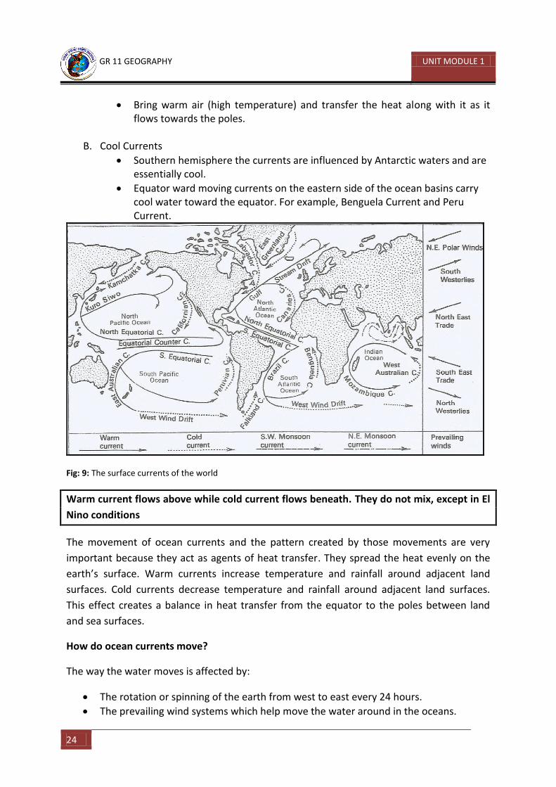
11.3.1.4: Ocean Currents and their Influence on the Climate
There are two types of water movements in the oceans:
Horizontal – the horizontal movement of ocean water on the surface is called ocean currents. These currents are powered by the prevailing wind systems and their patterns. Ocean current is an important factor that affects temperature. Temperature on the other hand is a very important feature of the climate system of the world.
Vertical – the vertical movement of ocean water is called tides, which is the rising of bottom water and the sinking of surface water. This rising and sinking effect of ocean water very much depends on the density of sea water itself. Density in this case refers to the weight or volume of sea water. The density of sea water depends upon the temperature and the amount of salt (salinity) in the water. The salinity or saltiness of sea water is one of its very important chemical properties.
It contains two of the most important mineral salts which are necessary for the
formation of shells and bones of marine organisms. These are sodium chloride
(NACL) and calcium carbonate (CaCO3). Salinity depends on the rate of evaporation
and the amount of fresh water brought in by rivers. Sea water is more salty when
evaporation is high, rainfall is low and there is no inflow of fresh water from rivers.
For example, the Red Sea. When this happens sea water is less dense, therefore, it is
lighter in volume. The rising and lowering of sea water is easier.
What are ocean currents?
Ocean currents are usually referred to as ‘the rivers of the seas’ because they move water
around the world’s oceans.
The main ocean currents are shown on Fig. 9. Each of the major currents can be identified or
labelled as cold or warm currents. Warm currents move from the equator to the poles. Cold
currents move from the poles to the equator. A current is termed warm or cold only when it
is warmer or colder than the surrounding waters of that latitude. We can generalize the
temperatures of the ocean currents as:
A. Warm Currents
Equatorial current, equatorial counter current associating warm waters in low-latitudes.
Pole ward moving currents on the western side of ocean basin carry warm water towards higher latitudes.
Kuroshio/North Pacific Current in the Pacific ocean and Gulf Stream/North Atlantic Drift in the Atlantic Ocean carry warm water toward the north and east.
GR 11 GEOGRAPHY UNIT MODULE 1
24
Bring warm air (high temperature) and transfer the heat along with it as it flows towards the poles.
B. Cool Currents
Southern hemisphere the currents are influenced by Antarctic waters and are essentially cool.
Equator ward moving currents on the eastern side of the ocean basins carry cool water toward the equator. For example, Benguela Current and Peru Current.
Fig: 9: The surface currents of the world
Warm current flows above while cold current flows beneath. They do not mix, except in El
Nino conditions
The movement of ocean currents and the pattern created by those movements are very
important because they act as agents of heat transfer. They spread the heat evenly on the
earth’s surface. Warm currents increase temperature and rainfall around adjacent land
surfaces. Cold currents decrease temperature and rainfall around adjacent land surfaces.
This effect creates a balance in heat transfer from the equator to the poles between land
and sea surfaces.
How do ocean currents move?
The way the water moves is affected by:
The rotation or spinning of the earth from west to east every 24 hours.
The prevailing wind systems which help move the water around in the oceans.
GR 11 GEOGRAPHY UNIT MODULE 3
25
As a result the water in the world’s oceans circulates in giant paths called gyres. They move
from west to east (clockwise direction) in the Northern Hemisphere and east to west (anti-
clockwise direction) in the Southern Hemisphere.
Until recently oceanographers have found that apart from surface currents there are also
deep ocean currents. In polar oceans the cold water sinks to the bottom and travels towards
the tropics. This deep cold water rises to the surface in the tropics. This is called upwelling. It
brings to the surface nutrients from near the bottom of the ocean to near the surface.
Upwelling is very important for all life in the sea. The water is then heated and returns as
warmer water to polar areas.
What causes tides?
When you were younger you probably built sand castles on the beach. Did it ever bother you
to see your hours and hours of handy work being destroyed by waves all in one go when the
water level rose? Your sand castle would have been washed away by the waves of the rising
tide.
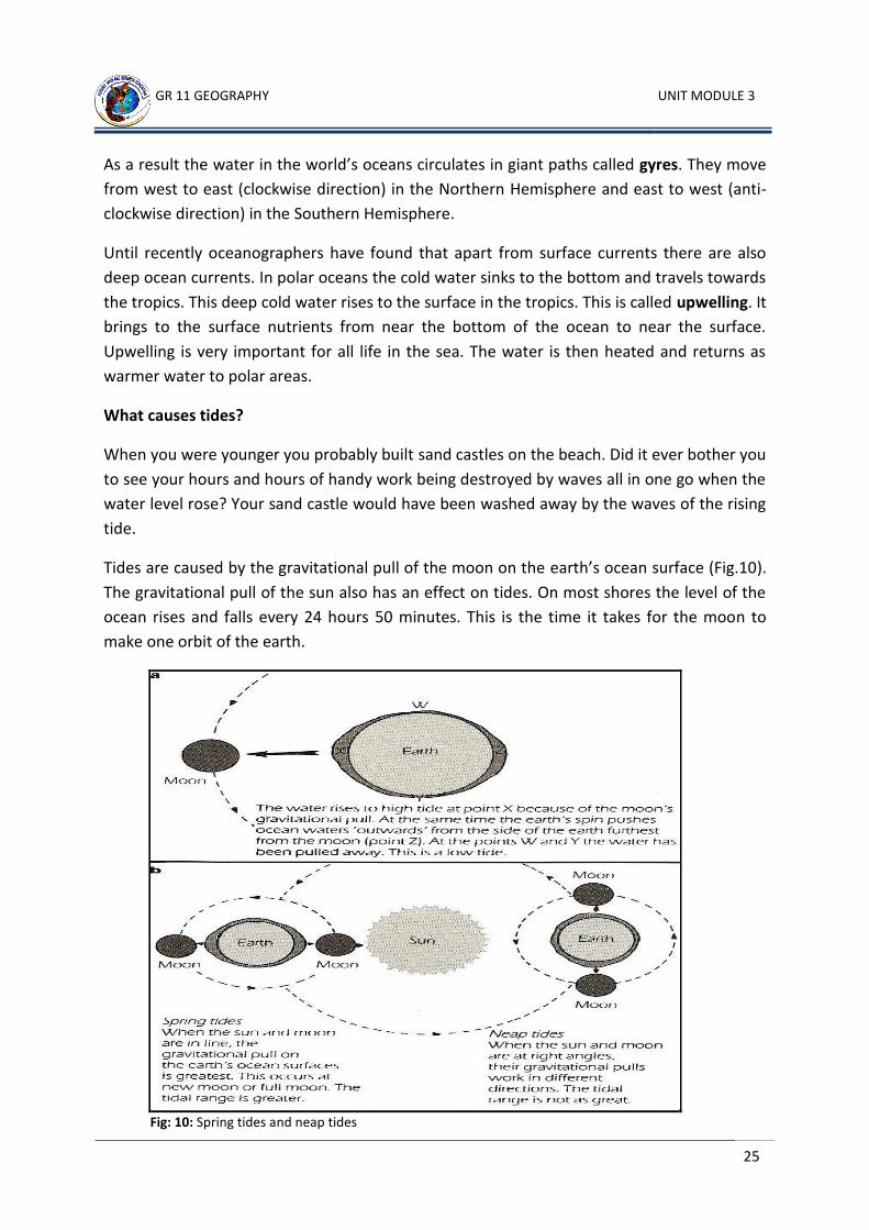
Tides are caused by the gravitational pull of the moon on the earth’s ocean surface (Fig.10).
The gravitational pull of the sun also has an effect on tides. On most shores the level of the
ocean rises and falls every 24 hours 50 minutes. This is the time it takes for the moon to
make one orbit of the earth.
Fig: 10: Spring tides and neap tides
GR 11 GEOGRAPHY UNIT MODULE 1
26
When the sun, earth and moon are in a straight line, as they are at Full Moon and New
Moon, the gravitational force is at its greatest because the sun and the moon are “pulling”
together. At these times, high tides are very high and low tides are very low, and they are
called spring tides. When the sun, earth and moon are not in a straight line, the sun and
moon are not “pulling” together and the gravitational force is less. At half moon, that is,
when the sun and the moon are “pulling” at right angle, the force is at its least and the
difference between high and low tides is not large. These tides are called neap tides. The
difference between high tide and low tide is called the tidal range. At spring tides it is high
and at neap tides it is low.
On the ocean surface, the tidal range is no more than a metre or so. In some coastal
locations the tidal range is great while at others it is hardly noticeable. This happens because
of the shape and slope of the coast line. In large enclosed basins like the Mediterranean Sea,
the tidal range is low. But in some coastal areas, long narrow deep bays called estuaries
have great tidal ranges. In some estuaries tidal bores occur. These are like walls of water
that surge up and down estuaries as the tide rises.
GR 11 GEOGRAPHY UNIT MODULE 3
27
Student Learning Activity 4
1. Explain the difference between the horizontal and vertical movements of ocean
water? _______________________________________________________________________________________________________________________________________________________________________________________________________________
2. How does density and winds affect these water movements? _______________________________________________________________________________________________________________________________________________________________________________________________________________
3. On which sides of continents do the warm ocean currents flow? In which direction do they flow in the northern hemisphere? _______________________________________________________________________________________________________________________________________________________________________________________________________________
4. Find a country in South America called Chile. You may need to use your atlas. If you had a boat and you put to sea off the coast of Chile, what current would carry you along? Is it a warm or cold current? Where would it take you? _________________________________________________________________________________________________________________________________________________________________________________________________________________________________________________________________________________________________________________________________________________________
5. What is a tide? Why do tides occur? _______________________________________________________________________________________________________________________________________________________________________________________________________________ __________________________________________________________________________________________________________________________________________
6. Which tide, a spring tide or a neap tide, has the greater tidal range? Why? _______________________________________________________________________________________________________________________________________________________________________________________________________________ __________________________________________________________________________________________________________________________________________
GR 11 GEOGRAPHY UNIT MODULE 1
28
7. Define these words:
a. Gyres__________________________________________________________________________________________________________________________
b. Spring tide___________________________________________________________________________________________________________________________
c. Neap tide___________________________________________________________________________________________________________________________
d. Tidal range__________________________________________________________________________________________________________________________
e. Inter-tidal Zone__________________________________________________________________________________________________________________________
f. Estuary________________________________________________________________________________________________________________________
CHECK YOUR ANSWERS AT THE END OF THE UNIT SUMMARY
GR 11 GEOGRAPHY UNIT MODULE 3
29
11.3.1.5: Marine Resources and their Ecosystems
An ecosystem is composed of a biome and the environment with which it interacts. A biome on the other hand refers to different communities of plants and animals and the different environments in which they live in. Therefore, when we talk about marine ecosystems we are referring to plants and animals that are part of life forms in the oceans and the different environments they live in. Marine environments can be places such as mangrove swamps, coral reefs, salt marshes, estuaries, lagoons, bays, deltas and islands. They are all part of the coast and the continental shelf. Marine resources simply refer to anything useful and valuable in the oceans that can
generate income and bring about economic change and progress in a person’s life. For
example, minerals, oil and gas, fish, crabs, lobsters and prawns. These can all be harnessed
into economic ventures and activities for individuals and countries who own those
resources.
What lives in the oceans?
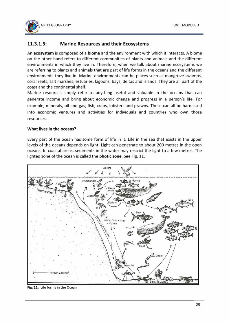
Every part of the ocean has some form of life in it. Life in the sea that exists in the upper levels of the oceans depends on light. Light can penetrate to about 200 metres in the open oceans. In coastal areas, sediments in the water may restrict the light to a few metres. The lighted zone of the ocean is called the photic zone. See Fig. 11.
Fig: 11: Life forms in the Ocean
GR 11 GEOGRAPHY UNIT MODULE 1
30
Since light is essential for nearly all plant life, most plants can live only in the photic zone.
The sea creatures that depend on these plants will also be restricted to this zone. There are
a few types of plants that can live without light and which gain their energy from chemicals
given off by the hot water springs on the ocean ridges where there is igneous activity. These
plants provide food for sea life near the ridges and produce ‘oases of life’ within the oceans.
With differences in the surface temperatures of the oceans there is great difference in the
plant and animal life from one place to another. There is very little variation in temperatures
below the surface or at depth both latitudinally or seasonally.
Marine life ranging from microscopic plankton to the largest of earth’s creatures, the
whales, can be divided into two groups. Pelagic life lives within the water and benthic life
lives on the ocean floor.
Pelagic life forms are free swimming (nektonic) and they drift with the ocean currents.
Benthic life forms are attached to the sea floor, for example coral, move over it like a
starfish, or burrow in the sediments that cover the floor like an anglerfish.
Food chains and food webs in the ocean
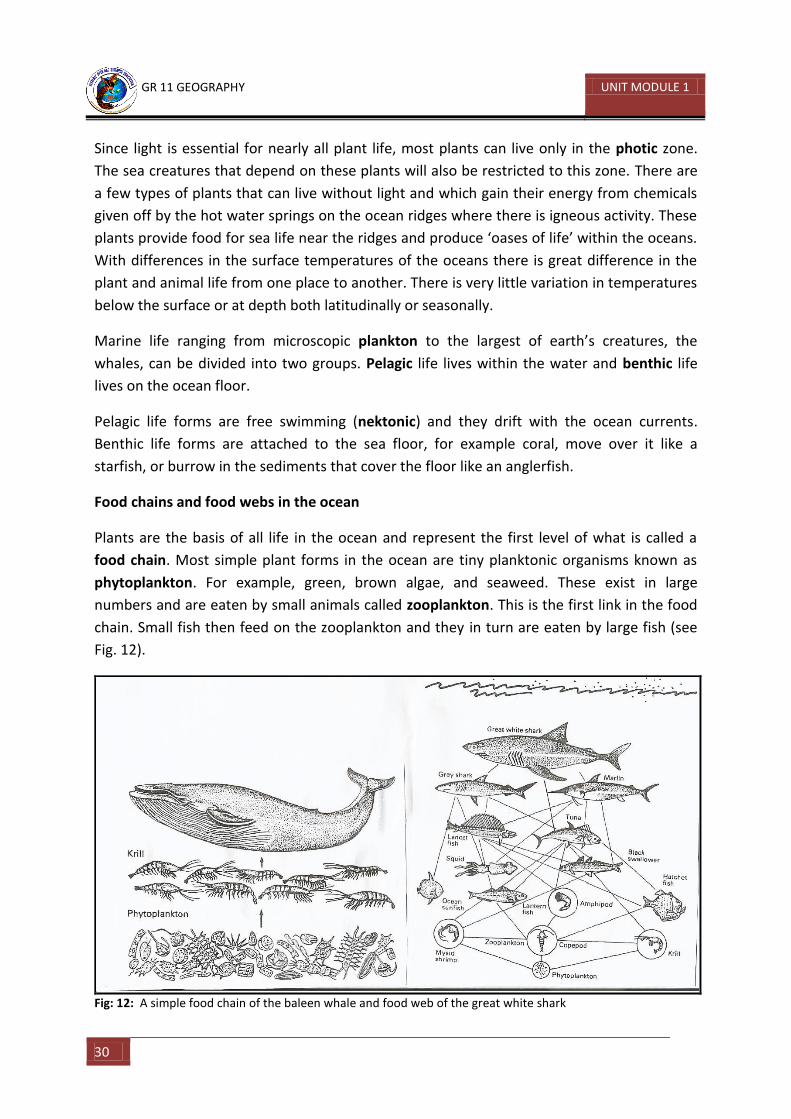
Plants are the basis of all life in the ocean and represent the first level of what is called a
food chain. Most simple plant forms in the ocean are tiny planktonic organisms known as
phytoplankton. For example, green, brown algae, and seaweed. These exist in large
numbers and are eaten by small animals called zooplankton. This is the first link in the food
chain. Small fish then feed on the zooplankton and they in turn are eaten by large fish (see
Fig. 12).
Fig: 12: A simple food chain of the baleen whale and food web of the great white shark
GR 11 GEOGRAPHY UNIT MODULE 3
31
Food chains are not usually simple straight lines. Instead each plant or animal may link with
and be part of many other food chains. This more complicated relationship is called a food
web. A food web summarises the living part of an ecosystem.
All living things are connected to each other in food chains and food webs. That is why
upsetting one part of an ecosystem can produce huge effects somewhere else. The way in
which the numbers of plants and animals in an ecosystem depend upon each other is called
the Balance of Nature.
Exploitation of ocean resources
The ocean is full of both food and energy resources. Most of the ocean’s food resources are
harvested from the continental shelves using different methods.
Fish and crustaceans are caught with lines, nets and traps. The ever increasing need for food
because of rapid growth in world population and improved technology in harvesting of fish
resources has led to a dramatic decline in the fish population. Many of the long established
fishing grounds of the world have been overfished.
Fishing is now taking place far out to sea, beyond the continental shelf in the waters of the
continental slopes and ocean depths. Large fishing nations such as Japan, Russia and the USA
have fleets of trawlers that operate in these areas using the latest technology such as:
Special underwater radar equipment to locate and track schools of fish.
Lights and electric currents which are sent into the water on a large tube – the light
attracts the fish and as they swim towards it the electric current stuns and kills them,
a powerful pump scoops up the fish.
Spotter aircraft to locate fish
Large processing ships on which the catch is cleaned and canned or frozen – these
large ships can stay at sea for many months and act as a base from which trawlers
operate.
Mineral and energy resources are also being explored and mined from the ocean floor. Oil
and natural gas are extracted from beneath the ocean floor. Sand and gravel are dredged
from the ocean floor. Salt and magnesium are extracted from sea water by evaporation. Oil
is the world’s most scarce non-renewable resource. Despite its scarcity the demand for oil
continues to increase because it provides the fuel to power motor vehicles, aircrafts and
ships. It is also used for a wide range of products including plastic and synthetic fibres.
As it became more and more difficult to find oil on land, the shallow waters of the
continental shelfs were explored. Today about 20 per cent of the world’s known oil reserves
GR 11 GEOGRAPHY UNIT MODULE 1
32
are in these offshore areas. Countries such as Australia and the USA have most of their oil
and natural gas extracted from the continental shelfs.
How are oil and natural gas extracted from the ocean?
Finding oil beneath the earth’s land surface is difficult enough – finding it and extracting it
from beneath the ocean is even more difficult.
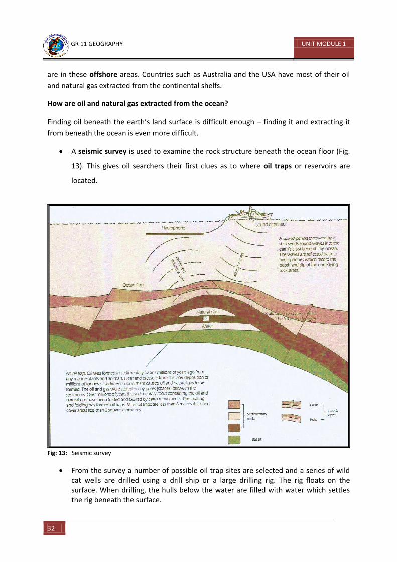
A seismic survey is used to examine the rock structure beneath the ocean floor (Fig.
13). This gives oil searchers their first clues as to where oil traps or reservoirs are
located.
Fig: 13: Seismic survey
From the survey a number of possible oil trap sites are selected and a series of wild cat wells are drilled using a drill ship or a large drilling rig. The rig floats on the surface. When drilling, the hulls below the water are filled with water which settles the rig beneath the surface.
GR 11 GEOGRAPHY UNIT MODULE 3
33
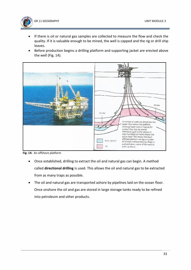
If there is oil or natural gas samples are collected to measure the flow and check the quality. If it is valuable enough to be mined, the well is capped and the rig or drill ship leaves.
Before production begins a drilling platform and supporting jacket are erected above the well (Fig. 14).
Fig: 14: An offshore platform
Once established, drilling to extract the oil and natural gas can begin. A method
called directional drilling is used. This allows the oil and natural gas to be extracted
from as many traps as possible.
The oil and natural gas are transported ashore by pipelines laid on the ocean floor.
Once onshore the oil and gas are stored in large storage tanks ready to be refined
into petroleum and other products.
GR 11 GEOGRAPHY UNIT MODULE 1
34
Learning Activity 5
1. Define these words:
a. Marine
ecosystem______________________________________________________________
_______________________________________________________________________
b. Benthic
life____________________________________________________________________
_______________________________________________________________________
c. Pelagic
life____________________________________________________________________
_______________________________________________________________________
d. Photic
zone___________________________________________________________________
_______________________________________________________________________
e. Plankton
_______________________________________________________________________
_______________________________________________________________________
f. Phytoplankton
_______________________________________________________________________
_______________________________________________________________________
g. Zooplankton
_______________________________________________________________________
_______________________________________________________________________
h. Nektonic
_______________________________________________________________________
_______________________________________________________________________
i. Food chain
_______________________________________________________________________
_______________________________________________________________________
GR 11 GEOGRAPHY UNIT MODULE 3
35
j. Food web
_______________________________________________________________________
_______________________________________________________________________
_______________________________________________________________________
2. What is dynamite fishing?
__________________________________________________________________________________________________________________________________________
3. Name four other seafood that are harvested from the oceans apart from fish?
__________________________________________________________________________________________________________________________________________
4. What does it mean by ‘sustainable and unsustainable’ use of ocean resources?
__________________________________________________________________________________________________________________________________________
CHECK YOUR ANSWERS AT THE END OF THE UNIT SUMMARY
END OF TOPIC 11.3.1
GR 11 GEOGRAPHY UNIT MODULE 1
36
TOPIC 11.3.2: OWNERSHIP AND CONTROL OF OCEANS AND MARINE RESOURCES
INTRODUCTION Welcome to Topic 2 Ownership and control of Oceans and Marine Resources. This topic contains three lessons and three learning activities.
Objectives or Aims On completion of this topic you will be able to: 1. demonstrate an understanding of the importance of the ocean as a
resource 2. outline the economic and social importance and ownership of the sea
areas and resources 3. describe and compare marine systems 4. interpret and create maps and diagrams that illustrate aspects of
oceanography 5. investigate and explain issues related to the use of oceans
This topic should be completed within (2) weeks. If you set an average of 3 hours per day, you should be able to complete the unit comfortably by the end of the assigned week. Try to do all the learning activities and compare your answers with the ones provided at the end of the unit. If you do not get a particular exercise right in the first attempt, you should not get discouraged but instead, go back and attempt it again. If you still do not get it right after several attempts then you should seek help from your friend or even your tutor. Do not pass any question without solving it first.
GR 11 GEOGRAPHY UNIT MODULE 3
37
11.3.2.1: Ocean / Sea Pollution
Ocean or sea pollution is the dumping and disposing of unwanted waste products into the
sea or the ocean. The ocean has traditionally been used as a support for ships, as a source of
food, and as a sink for waste. There is such a large volume of ocean that dumping unwanted
material is attractive to industries and to cities that wish to avoid paying the extra cost of
dumping on land, or do not wish to process or recycle their waste products. More than three
quarters of sea pollution comes from sources on land and a third of it is airborne, including
some pollutants from vehicle emissions. About 12 per cent comes from ships and boats, as a
result of operational discharges, accidents or general rubbish.
Different categories of ocean pollution and their effects
The oceans are becoming more and more polluted from:
Sewage disposal
Industrial wastes and slugdes
Pesticides, herbicides and fertilizers used in farming
Garbage dumping (includes plastic and general solid waste disposal)
A wide variety of household and industrial chemicals
Oil spills
Some of the effects of continuous and excessive dumping of waste into the oceans are:
Habitat degradation
Eutrophication (includes algae bloom)
Toxic pollution
Aerosol contamination
Emerging diseases (such as typhoid)
Coral reef destruction and reef damage
Causes and effects of oil spill
Polluted water not only affects the plant and animal life of the oceans but also affects those
animals that get food from the oceans. The most publicised ocean pollutant is oil. Each year
nearly 4 million tonnes of oil enter the oceans of the world. Of this, about 2.5 million tonnes
GR 11 GEOGRAPHY UNIT MODULE 1
38
escape into the ocean from waste disposal and run-off from the land surfaces. The rest of
the oil enters the ocean:
From tankers colliding or running aground at sea
From oil spills which occur when oil is being discharged into storage areas near
refineries located in ports or bays.
When oil is spilt in the ocean it stays on the surface because it is lighter than water. Because
oil and water do not mix, even small amounts spread rapidly across the ocean surface and
then get washed up on large areas of shorelines. Attempts to chemically treat or sink the oil
may further disrupt marine and beach ecosystems. If the oil spill is left untreated for a while
it floats as a slick. Slicks create problems for:
Surface feeding birds because the oil sticks to their feathers and stops them from
flying.
All sea life near the surface can either be killed or severely damaged by the toxic
effects of oil. The oil kills life and harms birds and marine mammals by causing
feathers and fur to lose their natural waterproof quality, which causes the animals to
drown or die of cold. Also these animals can become sick or poisoned when they
swallow the oil while preening (grooming their feathers and fur).
Beach resorts which depend heavily on tourism.
Oil spills often occur through accidents, such as the wrecks of the tanker Amoco Cadiz off the
coast of France in 1978 and the Exxon Valdez in Alaska in 1992.
GR 11 GEOGRAPHY UNIT MODULE 3
39
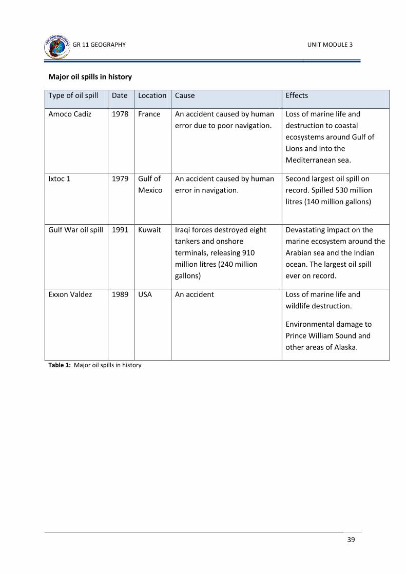
Major oil spills in history
Type of oil spill Date Location Cause Effects
Amoco Cadiz 1978 France An accident caused by human
error due to poor navigation.
Loss of marine life and
destruction to coastal
ecosystems around Gulf of
Lions and into the
Mediterranean sea.
Ixtoc 1 1979 Gulf of
Mexico
An accident caused by human
error in navigation.
Second largest oil spill on
record. Spilled 530 million
litres (140 million gallons)
Gulf War oil spill 1991 Kuwait Iraqi forces destroyed eight
tankers and onshore
terminals, releasing 910
million litres (240 million
gallons)
Devastating impact on the
marine ecosystem around the
Arabian sea and the Indian
ocean. The largest oil spill
ever on record.
Exxon Valdez 1989 USA An accident Loss of marine life and
wildlife destruction.
Environmental damage to
Prince William Sound and
other areas of Alaska.
Table 1: Major oil spills in history
GR 11 GEOGRAPHY UNIT MODULE 1
40
Learning Activity 6
1. Why have the oceans often been used as dumping grounds?
_______________________________________________________________________________________________________________________________________________________________________________________________________________
2. How can ocean pollution affect us?
_______________________________________________________________________________________________________________________________________________________________________________________________________________
3. What is an oil slick? _______________________________________________________________________________________________________________________________________________________________________________________________________________
4. Describe the ways in which an oil slick can appear on the ocean surface? _______________________________________________________________________________________________________________________________________________________________________________________________________________
5. What type of damage is caused by oil slicks? _______________________________________________________________________________________________________________________________________________________________________________________________________________
6. What is eutrophication? _______________________________________________________________________________________________________________________________________________________________________________________________________________
7. Explain the term ‘algae bloom’? _______________________________________________________________________________________________________________________________________________________________________________________________________________
CHECK YOUR ANSWERS AT THE END OF THE UNIT SUMMARY
GR 11 GEOGRAPHY UNIT MODULE 3
41
11.3.2.2 INTERNATIONAL TREATIES/AGREEMENTS AND ORGANISTIONS
Ownership and control of oceans and marine resources is now a major global concern. In an overpopulated world with a rapid decline in non-renewable resources such as oil and gas, and an ever increasing demand for huge quantities of energy consumption, it is important for us to address questions such as: ‘Why marine conservation and preservation’?
The oceans are a very important part of our environment because
They are the source of all our fresh water through the water cycle
They provide us with millions of tonnes of food each year
They absorb carbon dioxide from the air and help prevent global warming
They break down much of the waste produced by human activities such as
sewage.
Over the past twenty years, people’s activities have expanded so rapidly that they have
begun to affect the oceans. People are putting so much waste into the oceans (oil, sewage,
chemicals etc), that in some places the oceans are becoming unsuitable for living things. For
example, the coastal regions of the North Sea between the United Kingdom and Northern
Europe are now so heavily polluted that fish cannot live there.
The oceans are not being exploited in a sustainable manner. Fish are being caught in such
great numbers that they cannot renew their populations. Many types of fish have been so
heavily fished they are at risk of becoming extinct.
It is mainly the developed, industrial nations that are responsible for polluting and
overfishing the oceans. The oceans are a resource that everybody in the world should share.
All countries of the world have a duty to ensure that the oceans are not over exploited. It is
important that nations co-operate to preserve our marine resources.
International co-operation, treaties and agreements
Disputes and disagreements between nations over their rights to territorial waters have
become increasingly common. For centuries there was a tradition known as ‘the freedom of
the high seas’. This meant that any nation had the right to exploit the resources of the
oceans.
This situation has changed as coastal nations have made claims to the ocean waters off their
coast. These are called territorial waters. Agreements have been made between some
countries to control exploitation of the ocean resources. Some international laws and
agreements have also been introduced.
GR 11 GEOGRAPHY UNIT MODULE 1
42
The first major international conference under the United Nations Convention on the oceans took place in 1930. Two main issues were raised and have been the centre of debate ever since and these are:
How extensive should territorial zones be?
Should the open oceans be a common world heritage?
The third UN Conference on the Law of the Sea (UNCLOS ) provides a model for all coastal nations to follow:
It placed 40 per cent of the oceans under the control of coastal states. These countries were granted territorial waters 12 nautical miles (18 kilometres) from land. This means that any coastal country had territorial rights and ownership over sea surface and below surface from their shores, as far as 18 kilometres out to sea.
The convention also gives responsibility to each coastal nation for the management of the oceans within 200 nautical miles (370 kilometers) offshore. This is called an Exclusive Economic Zone (EEZ). This means that coastal countries have exclusive rights to manage, protect and develop their marine resources within this zone without interference from others. It has the sole discretion to get into trade agreements with any independent nation to develop and trade its marine resources. Anything outside of this is not within their reach and is outside of their national and international sea borders.
The convention also encourages nations to co-operate in the conservation and management of living marine resources such as fish, prawns, shell fish. Coastal nations must now make laws to prevent industrial waste from polluting the oceans and destroying the marine life.
Papua New Guinea is one of the 159 countries that have signed the convention. It is important that people in PNG are aware that they have a responsibility to conserve their marine resources within the EEZ.
Of the remaining 60 per cent of the oceans which is outside national EEZ is international territory. This seabed area and its marine resources have been declared the common heritage of mankind. Any mining of the seabed that takes place in this international zone must be controlled by the International Seabed Authority.
This proposal led to disagreements. The developed world countries are reluctant to share their technological expertise in deep-ocean mining of future resources such as manganese nodules, with the developing nations.
Several major maritime nations including the USA and the UK have refused to sign any such declaration. It seems that this proposal and others which aim to better manage the oceans have little future.
Papua New Guinea is a signatory to several international treaties and agreements:
International Maritime Organization – it provides surveillance, monitors and manages all shipping and navigation issues worldwide.
GR 11 GEOGRAPHY UNIT MODULE 3
43
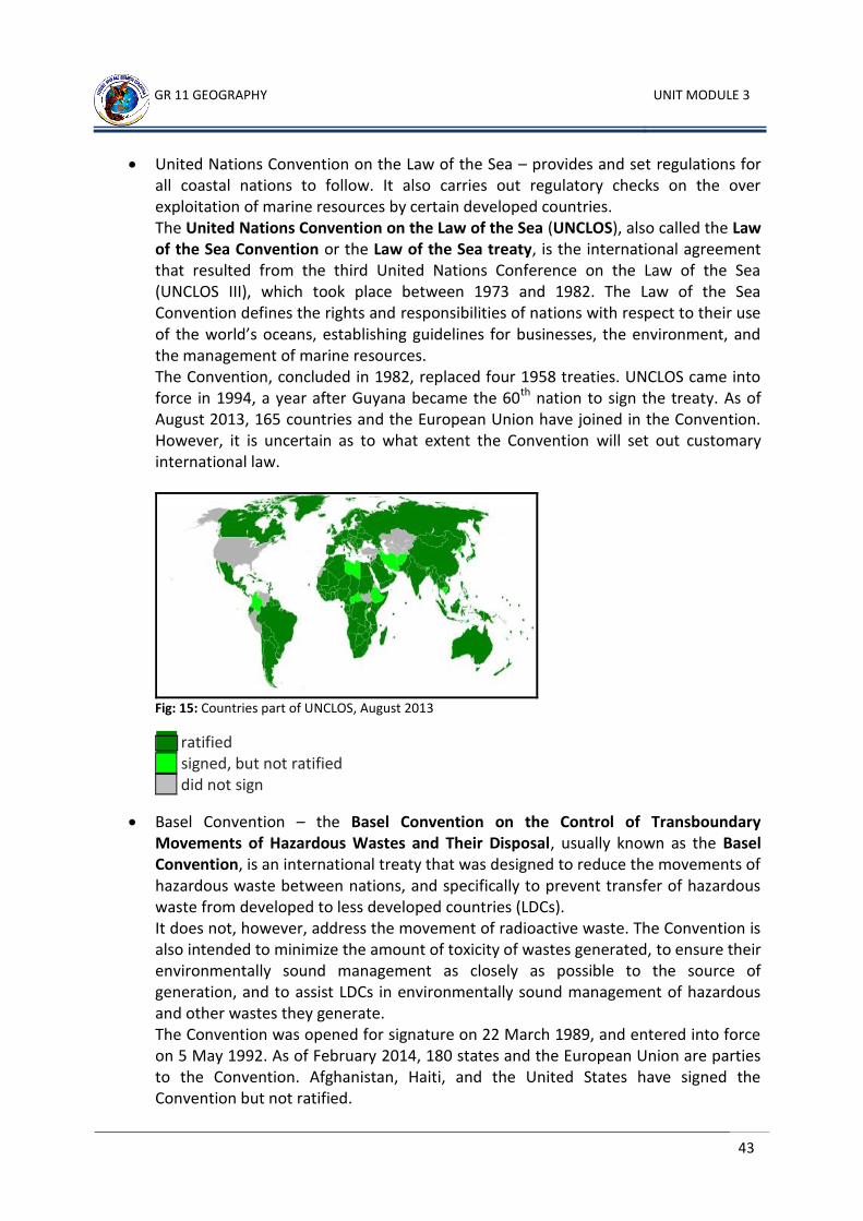
United Nations Convention on the Law of the Sea – provides and set regulations for all coastal nations to follow. It also carries out regulatory checks on the over exploitation of marine resources by certain developed countries. The United Nations Convention on the Law of the Sea (UNCLOS), also called the Law of the Sea Convention or the Law of the Sea treaty, is the international agreement that resulted from the third United Nations Conference on the Law of the Sea (UNCLOS III), which took place between 1973 and 1982. The Law of the Sea Convention defines the rights and responsibilities of nations with respect to their use of the world’s oceans, establishing guidelines for businesses, the environment, and the management of marine resources. The Convention, concluded in 1982, replaced four 1958 treaties. UNCLOS came into force in 1994, a year after Guyana became the 60th nation to sign the treaty. As of August 2013, 165 countries and the European Union have joined in the Convention. However, it is uncertain as to what extent the Convention will set out customary international law.
Fig: 15: Countries part of UNCLOS, August 2013
ratified signed, but not ratified did not sign
Basel Convention – the Basel Convention on the Control of Transboundary Movements of Hazardous Wastes and Their Disposal, usually known as the Basel Convention, is an international treaty that was designed to reduce the movements of hazardous waste between nations, and specifically to prevent transfer of hazardous waste from developed to less developed countries (LDCs). It does not, however, address the movement of radioactive waste. The Convention is also intended to minimize the amount of toxicity of wastes generated, to ensure their environmentally sound management as closely as possible to the source of generation, and to assist LDCs in environmentally sound management of hazardous and other wastes they generate. The Convention was opened for signature on 22 March 1989, and entered into force on 5 May 1992. As of February 2014, 180 states and the European Union are parties to the Convention. Afghanistan, Haiti, and the United States have signed the Convention but not ratified.
GR 11 GEOGRAPHY UNIT MODULE 1
44
As of 2014 there are 181 parties to the treaty. The UN member states that are not party to the treaty are Angola, Burma, East Timor, Fiji, Grenada, Haiti, San Marino, Sierra Leone, Solomon Islands, South Sudan, Tajikistan, Tuvalu, United States, and Vanuatu.
Marpol Agreement – Marpol 73/78 is the International Convention for the Prevention of Pollution From Ships, 1973 as modified by the Protocol of 1978. (“Marpol” is short for marine pollution and 73/78 short for the years 1973 and 1978.) Marpol 73/78 is one of the most important international marine environmental conventions. It was designed to minimize pollution of the seas, including dumping, oil and exhaust pollution. Its stated objective is to preserve the marine environment through the complete elimination of pollution by oil and other harmful substances and the minimization of accidental discharge of such substances. The original MARPOL was signed on 17 February 1973, but did not come into force due to lack of ratifications. The current convention is a combination of 1973 Convention and the 1978 Protocol. It entered into force on 2 October 1983. As of May 2013, 152 states, representing 99.2 per cent of the world’s shipping tonnage, are parties to the convention. All ships flagged under countries that are signatories to MARPOL are subject to its requirements, regardless of where they sail and member nations are responsible for vessels registered under their respective nationalities.
London Convention – the London Convention was a treaty made in 1884 between the United Kingdom, as a paramount power in South Africa, and the South African Republic. The London Convention superseded the 1881 Pretoria Convention. Historical Background The treaty governed the relations between the ZAR and the United Kingdom, following the retrocession of the South African Republic in the aftermath of the First Boer War. Content of the Convention
The convention incorporated the bulk of the earlier Pretoria Convention, but with two major differences:
1) Name of the Country – it corrected the name of the country, from the Transvaal Territory used in the 1881 Pretoria convention, to the South African Republic at the request of the South African republic Volksraad.
2) Suzerainty – the main and most important aspect of the London Convention is that British suzerainty (dominion) over the South African Republic, was relinquished (given up).
The Papua New Guinea government is very much aware of issues of climate change and global warming affecting some of its island communities such as Manam and Kataret Islanders. It is committed to adhere by these agreements and is enforcing these regulations through organisations such as:
National Maritime Authority
National Fisheries Authority
Office of Climate Change and Monitoring

GR 11 GEOGRAPHY UNIT MODULE 3
45
Department of Mining and Petroleum
Department of Environment and Conservation
Activity 7
1. What does the phrase ‘Common Heritage of Mankind’ mean?
_______________________________________________________________________________________________________________________________________________________________________________________________________________
2. Explain the importance of the EEZ to all coastal nations? _______________________________________________________________________________________________________________________________________________________________________________________________________________
3. What are territorial waters? __________________________________________________________________________________________________________________________________________
4. What does the abbreviation UNCLOS stand for? __________________________________________________________________________________________________________________________________________
5. Define these terms a. Exploit
______________________________________________________________________________________________________________________________
b. Heritage ______________________________________________________________________________________________________________________________
c. Off-shore
______________________________________________________________________________________________________________________________
d. On-shore ______________________________________________________________________________________________________________________________ CHECK YOUR ANSWERS AT THE END OF THE UNIT SUMMARY
GR 11 GEOGRAPHY UNIT MODULE 1
46
11.3.2.3: Indigenous Rights to Seas and Resources
What are Indigenous Rights?
Every indigenous coastal community, especially in the islands of the Pacific including Papua
New Guinea, have their traditional ownership rights over marine resources, within their
traditional fishing and diving grounds.
Throughout generations, there have always been a common understanding and a clear
demarcation of sea or coastal boundaries commonly agreed and observed by neighbouring
clans or tribes. Any trespassing usually resulted in disagreements and disputes. Of the many
island and coastal communities of the islands of the Pacific, there had always been this oral
tradition and unwritten law, guided by peoples’ morals and ethics that allowed people to
respect one another.
There was this state of interdependency that people had the obligation to protect, and
preserve one another’s resources so that there was enough to support, and help each other
in times of disasters or emergencies. There was this spirit of sharing and caring for one
another. If people overfished, they always shared with another family so that what was
harvested on a particular day was not wasted. With this spirit of community, indigenous
people had a way of preserving and conserving their marine resources for the future
generation.
Traditional management techniques
Most indigenous communities, though illiterate, used simple technologies that were
effective and practical. Some of the techniques that were used include:
Selective fishing
Traditional nature friendly techniques such as diving, use of fishing guns, nets, baskets, harpoons
Reserved specific areas for specific purposes
Why is there a need of management of protected areas?
It is very important that indigenous people participate effectively in the management of
protected areas established on their lands or territories. For example, in Papua New Guinea,
land is owned by the clan. The land is very important as it supplies all their needs for
survival. Without the land, people would perish. Traditionally, resources had always been
divided equally among members of the clan.
Today, with increasing population and the increasing demand for resources, Papua New
Guineans have a huge problem of resource management. We must think globally and act
GR 11 GEOGRAPHY UNIT MODULE 3
47
locally, when it comes to resource use and management. If people, especially our indigenous
communities are not made aware of the fact that, if we don’t take positive steps and
measures to control the way we consume our resources, they will all run out in less than 50
years. Our future generations will be left with nothing and the world will be a very chaotic
place to live.
When people’s needs and wants are not met through the resources that are available, the
socio-economic impacts will be far greater than the government can handle and even society
itself. Socio-economic issues such as:
Lawlessness and lack of law and order will be on the rise
Crimes like murder and rape will escalate
Consumption of drugs, alcohol and substance abuse will increase.
Unemployment rate will increase Papua New Guinea Conservation Laws
Papua New Guinea’s marine environment can be affected by mine waste, sewage disposal,
overfishing, and reef damage. The Conservation Areas Act was enacted in 1978 and was
passed in 1980. It regulates and governs wildlife management areas. Nothing workable and
practical is in place yet about the marine resources and management practices, control and
usage within the EEZ. (Exclusive Economic Zone refers to the waters/seas from a Pacific
country’s shores to about 360 kilometres from the shore)
Problems:
Some mines dispose of their waste rock into the sea which can cause damage to coral reefs, fish, and other marine resources
Untreated sewage can cause pollution because it contains poisonous chemicals and bacteria which can lead to disease in both humans and the marine environment.
Possible Solutions:
1. Mines:
Keeping waste on the land
Using nets to stop mine waste from spreading out to sea(e.g. Ramu Nico)
2. Sewage:
Treating sewage before it is released into the sea
Preventing industrial waste entering the sewage system
Not using chlorine to disinfect the water supply
Conserving water
GR 11 GEOGRAPHY UNIT MODULE 1
48
Activity 8
1. Complete the table.
Papua New Guinea Fishing Methods
Traditional Modern
2. Briefly explain these concepts.
A. Deep Sea Mine Tailings?
______________________________________________________________________________________________________________________________________________________________________________________________________________________________________________________________________________________________________________________________________________________________________________________________________________________________
B. Deep Sea Mining? ______________________________________________________________________________________________________________________________________________________________________________________________________________________________________________________________________________________________________________________________________________________________________________________________________________________________
CHECK YOUR ANSWERS AT THE END OF THE UNIT SUMMARY
END OF TOPIC 11.3.2
GR 11 GEOGRAPHY UNIT MODULE 3
49
TOPIC 11.3.3: USE OF OCEANS
INTRODUCTION Welcome to Topic 3. Use of Oceans. This topic contains six lessons and six learning activities.
Objectives or Aims
1. demonstrate an understanding of the importance of the ocean as a resource. 2. outline the economic and social importance and ownership of the sea areas and
resources. 3. interpret and create maps and diagrams that illustrate aspects of oceanography. 4. investigate and explain issues related to the use of oceans.
This topic should be completed within (4) weeks. If you set an average of 3 hours per day, you should be able to complete the unit comfortably by the end of the assigned week. Try to do all the learning activities and compare your answers with the ones provided at the end of the unit. If you do not get a particular exercise right in the first attempt, you should not get discouraged but instead, go back and attempt it again. If you still do not get it right after several attempts then you should seek help from your friend or even your tutor. Do not pass any question without solving it first.
GR 11 GEOGRAPHY UNIT MODULE 1
50
11.3.3.1: Fishing Methods and Their Sustainability
The planet earth’s various oceans form one single ecosystem which covers 361 million
square kilometres, or 70% of the earth’s surface. Exploitation of renewable and non-
renewable resources has steadily increased. No sooner do we realise that their potential are
threatened by over-exploitation.
The oceans supply about 80% of all living aquatic resources amounting to 110 million tonnes.
The rest comes from inland waters. At sea, production relies to a large extent (80%) on
fishing, simply harvesting natural resources.
Fishing is the practice of acquiring fish. It has been common to men since we understood
how to use machines. Fisheries and aquaculture are directly or indirectly a source of
livelihood for over 500 million people mostly in developing countries like Papua New Guinea
in terms of food consumption, employment or economic purposes. This shows the
interaction between man and his environment for survival.
Conditions necessary for fish breeding
Environmental conditions necessary for fish breeding:
sea water contains two very important mineral salts which are sodium chloride and calcium carbonate. They are necessary for the formation of skeletons and bones of some fish species.
The shallow waters of the continental shelves where cold currents interchange with warm currents.
The water temperature should not be too hot or too cold.
There should be an abundance of food and nutrient supply for fish to breed and multiply.
Areas where corals and coral reefs are dominant.
Methods of fishing used by fishermen
Traditionally, PNG clans have developed indigenous fishing methods using vines and bamboos sewn together into nets to harvest and share with the entire village. The other method was the use of bamboo spears to go spear-diving, which they usually catch a handful of fish for their families. People also use hooks with baits attached to catch fish.
Most common modern commercial fishing method is trawling. Trawling is simply towing a net through the water. A trawl net is funnel shaped, and can harvest bottom dwelling fish when dragged along the ocean floor. Pelagic fish can be caught by mid-water trawling, in which the net is towed through the water column between the surface and the bottom.
GR 11 GEOGRAPHY UNIT MODULE 3
51
Gillnetting can also be used to harvest bottom or pelagic fish, but is a passive fishing method. A gillnet is a wall of netting set in a straight line, equipped with weights at the bottom and floats at the top, and usually anchored at each end. Fish swim through the invisible net and are entangled when their gills are caught in the webbing, hence the name gillnetting. If allowed to drift freely, the method is referred to as drift net fishing.
Rather than a net, long lining uses baited hooks on off shoots of a single main line to catch any fish at any level. The line can be anchored at the bottom in areas too rough for trawling, or set drift, suspended by floats. It is currently used to catch swordfish.
Purse seines are walls of netting, used to encircle entire schools of fish or near the surface. A drawstring cable is threaded through the bottom of the net. When the cable is pulled tight, enclosing the fish in a pouch, the catch is hurled on board with a clip net in a process called brailing.
A weir is a passive fishing method consisting of brush or twine fences permanently attached to the bottom. Two prolonged fences called leaders divert fish to swim voluntarily into successive enclosures known as the heart, pound and pocket.
Jigging is the setting of a line, with baited hooks or lures that is continually jerked. The motion achieved by a hand or jigging machine induces fish to take the hook.
Used extensively in whaling days, harpoons are still used today to catch swordfish, shark and tuna. Thrown by hand or shot by mounted guns, harpoons are each tipped with a barb and attached to a long line with a buoy at the end. The line is free of the boat, and fish are followed with assistance of the buoy until they tire and can be hauled aboard. This method involves a hand line or a rod and reel, and sometimes with more than one hook. Line fish are used on commercial ski boats and sometimes larger deck boats. It is a fairly selective method. By varying hook sizes, bait types and carefully selecting localities, species can be specifically targeted thereby reducing by catch. The fish caught are also of very good quality as they are individually handled.
Sustainability and unsustainability of the different fishing methods
All these methods developed have improved the standard of people in terms of catching and
storing of fish and other marine resources. However, they all have certain effects on the
environment. With the availability of these methods for usage and the advancement of
technology in aquaculture and fisheries, the issue of over fishing is a global concern
nowadays.
Overfishing is traditionally defined as harvesting so many fish that the yield is less than it
would be if fishing were reduced. This has resulted in the oceans declining fish stock and
some species of fish are in danger of becoming extinct. The declining number of fish in the
oceans has become a real concern for environmentalists and marine scientists. Although the
marine resources are renewable, they are limited. Overfishing has reduced some species of
GR 11 GEOGRAPHY UNIT MODULE 1
52
fish to near extinction and has depleted numerous populations of targeted species in
particular areas. The depletion in stocks of commercially targeted fish, as well as the
depletion of marine species that are accidently caught with targeted species, has changed
and disturbed the food web of the world’s ocean resources, resulting in a less yield of fish.
There are also other issues and problems which are associated with fishing methods, such as
cyanide fishing. In this fishing technique, fisheries squirt sodium cyanide to stun fish without
killing them, making them easy to catch. Cyanide fishing on coral reefs began in the 1960’s to
supply the international aquarium trade. Since the early 1980’s, a much profitable business
had emerged, supplying live reef fish for the hotels of Hong Kong, Singapore and mainland
China. Some 20,000 tonnes of live fish are eaten annually in the restaurants of Hong Kong,
for every live fish caught using cyanide, a square meter of the coral reef home is killed.
What is dynamite fishing?
In this fishing technique, dynamite or other explosives are set off under water. The dead fish
floating to the surface are then simply scooped up. The explosives completely destroy the
underwater environment, leaving it as rubble. Dynamite fishing has massively contributed to
the destruction of the South East Asian coral reefs over the past 20 years.
The impact of this issue on PNG
The problem of overfishing and damaging coral reef has been caused by the usage of the
most modern commercial fishing methods. They have been recognised both locally and
globally. This is so because fishing is carried out in almost all the countries of the world,
except those located inland.
The issue of overfishing and damaging of coral reefs can also be found in the waters of PNG.
This is evident in Pere village, Titan tribe of Manus province where grouper species of fish
found are increasingly rare because of high demand from mainland Asia.
Research done by environmental organisation called Nature Conservancy showed the
depleting of fish in PNG waters, Manus Province. Another province facing the same problem
is Madang province. Dynamite fishing is illegal but people continue to use this method to fish
in the Madang lagoon, a 49 square kilometre body of water averaging 30-40 metres deep
and spotted on them were numerous holes which were caused by the usage of dynamite.
Despite the effects these fishing methods have on the environment, there are ways in which
we can conserve and sustain them. Sustainable fishery can now, produce consistent output
over an indefinite period without damaging the surrounding environment. There are certain
institutions, organisations and individuals who work to make sure the fisheries is sustainable
for our future generation. Institutions include Department of Environment and
Conservation, organisations like Greenpeace, Nature Conservancy, and individual scientists
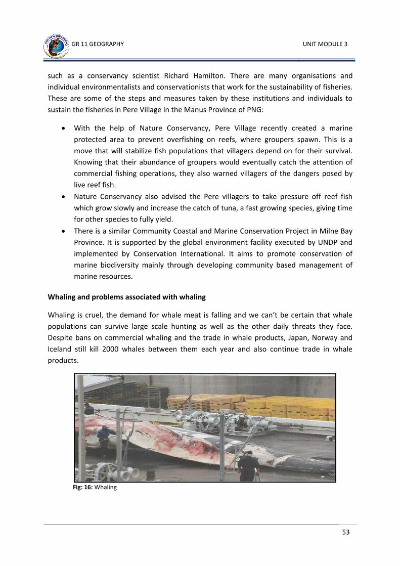
GR 11 GEOGRAPHY UNIT MODULE 3
53
such as a conservancy scientist Richard Hamilton. There are many organisations and
individual environmentalists and conservationists that work for the sustainability of fisheries.
These are some of the steps and measures taken by these institutions and individuals to
sustain the fisheries in Pere Village in the Manus Province of PNG:
With the help of Nature Conservancy, Pere Village recently created a marine
protected area to prevent overfishing on reefs, where groupers spawn. This is a
move that will stabilize fish populations that villagers depend on for their survival.
Knowing that their abundance of groupers would eventually catch the attention of
commercial fishing operations, they also warned villagers of the dangers posed by
live reef fish.
Nature Conservancy also advised the Pere villagers to take pressure off reef fish
which grow slowly and increase the catch of tuna, a fast growing species, giving time
for other species to fully yield.
There is a similar Community Coastal and Marine Conservation Project in Milne Bay
Province. It is supported by the global environment facility executed by UNDP and
implemented by Conservation International. It aims to promote conservation of
marine biodiversity mainly through developing community based management of
marine resources.
Whaling and problems associated with whaling
Whaling is cruel, the demand for whale meat is falling and we can’t be certain that whale
populations can survive large scale hunting as well as the other daily threats they face.
Despite bans on commercial whaling and the trade in whale products, Japan, Norway and
Iceland still kill 2000 whales between them each year and also continue trade in whale
products.
Fig: 16: Whaling
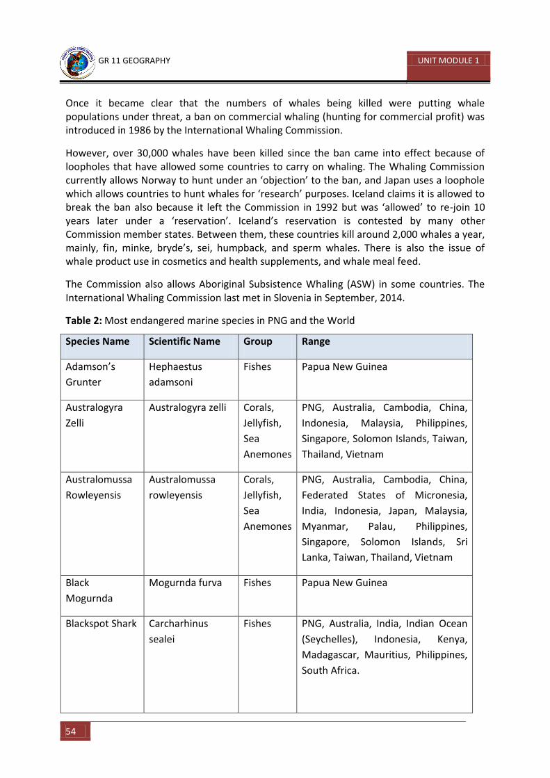
GR 11 GEOGRAPHY UNIT MODULE 1
54
Once it became clear that the numbers of whales being killed were putting whale populations under threat, a ban on commercial whaling (hunting for commercial profit) was introduced in 1986 by the International Whaling Commission.
However, over 30,000 whales have been killed since the ban came into effect because of loopholes that have allowed some countries to carry on whaling. The Whaling Commission currently allows Norway to hunt under an ‘objection’ to the ban, and Japan uses a loophole which allows countries to hunt whales for ‘research’ purposes. Iceland claims it is allowed to break the ban also because it left the Commission in 1992 but was ‘allowed’ to re-join 10 years later under a ‘reservation’. Iceland’s reservation is contested by many other Commission member states. Between them, these countries kill around 2,000 whales a year, mainly, fin, minke, bryde’s, sei, humpback, and sperm whales. There is also the issue of whale product use in cosmetics and health supplements, and whale meal feed.
The Commission also allows Aboriginal Subsistence Whaling (ASW) in some countries. The International Whaling Commission last met in Slovenia in September, 2014.
Table 2: Most endangered marine species in PNG and the World
Species Name Scientific Name Group Range
Adamson’s
Grunter
Hephaestus
adamsoni
Fishes Papua New Guinea
Australogyra
Zelli
Australogyra zelli Corals,
Jellyfish,
Sea
Anemones
PNG, Australia, Cambodia, China,
Indonesia, Malaysia, Philippines,
Singapore, Solomon Islands, Taiwan,
Thailand, Vietnam
Australomussa
Rowleyensis
Australomussa
rowleyensis
Corals,
Jellyfish,
Sea
Anemones
PNG, Australia, Cambodia, China,
Federated States of Micronesia,
India, Indonesia, Japan, Malaysia,
Myanmar, Palau, Philippines,
Singapore, Solomon Islands, Sri
Lanka, Taiwan, Thailand, Vietnam
Black
Mogurnda
Mogurnda furva Fishes Papua New Guinea
Blackspot Shark Carcharhinus
sealei
Fishes PNG, Australia, India, Indian Ocean
(Seychelles), Indonesia, Kenya,
Madagascar, Mauritius, Philippines,
South Africa.
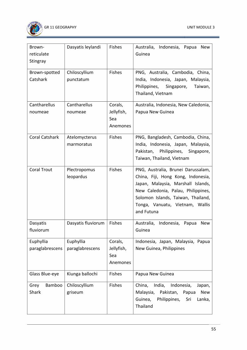
GR 11 GEOGRAPHY UNIT MODULE 3
55
Brown-
reticulate
Stingray
Dasyatis leylandi Fishes Australia, Indonesia, Papua New
Guinea
Brown-spotted
Catshark
Chiloscyllium
punctatum
Fishes PNG, Australia, Cambodia, China,
India, Indonesia, Japan, Malaysia,
Philippines, Singapore, Taiwan,
Thailand, Vietnam
Cantharellus
noumeae
Cantharellus
noumeae
Corals,
Jellyfish,
Sea
Anemones
Australia, Indonesia, New Caledonia,
Papua New Guinea
Coral Catshark Atelomycterus
marmoratus
Fishes PNG, Bangladesh, Cambodia, China,
India, Indonesia, Japan, Malaysia,
Pakistan, Philippines, Singapore,
Taiwan, Thailand, Vietnam
Coral Trout
Plectropomus
leopardus
Fishes PNG, Australia, Brunei Darussalam,
China, Fiji, Hong Kong, Indonesia,
Japan, Malaysia, Marshall Islands,
New Caledonia, Palau, Philippines,
Solomon Islands, Taiwan, Thailand,
Tonga, Vanuatu, Vietnam, Wallis
and Futuna
Dasyatis
fluviorum
Dasyatis fluviorum Fishes Australia, Indonesia, Papua New
Guinea
Euphyllia
paraglabrescens
Euphyllia
paraglabrescens
Corals,
Jellyfish,
Sea
Anemones
Indonesia, Japan, Malaysia, Papua
New Guinea, Philippines
Glass Blue-eye Kiunga ballochi Fishes Papua New Guinea
Grey Bamboo
Shark
Chiloscyllium
griseum
Fishes China, India, Indonesia, Japan,
Malaysia, Pakistan, Papua New
Guinea, Philippines, Sri Lanka,
Thailand
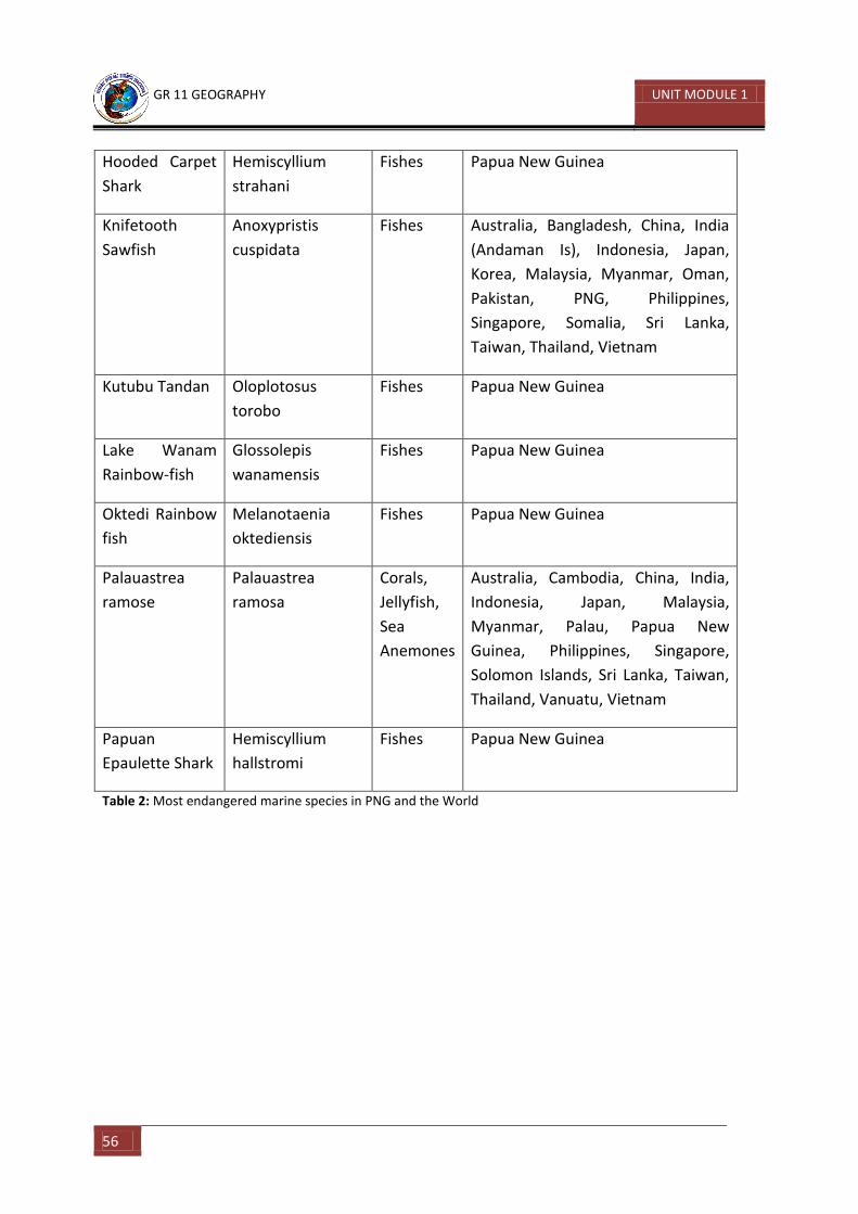
GR 11 GEOGRAPHY UNIT MODULE 1
56
Hooded Carpet
Shark
Hemiscyllium
strahani
Fishes Papua New Guinea
Knifetooth
Sawfish
Anoxypristis
cuspidata
Fishes Australia, Bangladesh, China, India
(Andaman Is), Indonesia, Japan,
Korea, Malaysia, Myanmar, Oman,
Pakistan, PNG, Philippines,
Singapore, Somalia, Sri Lanka,
Taiwan, Thailand, Vietnam
Kutubu Tandan Oloplotosus
torobo
Fishes Papua New Guinea
Lake Wanam
Rainbow-fish
Glossolepis
wanamensis
Fishes Papua New Guinea
Oktedi Rainbow
fish
Melanotaenia
oktediensis
Fishes Papua New Guinea
Palauastrea
ramose
Palauastrea
ramosa
Corals,
Jellyfish,
Sea
Anemones
Australia, Cambodia, China, India,
Indonesia, Japan, Malaysia,
Myanmar, Palau, Papua New
Guinea, Philippines, Singapore,
Solomon Islands, Sri Lanka, Taiwan,
Thailand, Vanuatu, Vietnam
Papuan
Epaulette Shark
Hemiscyllium
hallstromi
Fishes Papua New Guinea
Table 2: Most endangered marine species in PNG and the World
GR 11 GEOGRAPHY UNIT MODULE 3
57
Activity 9
1. Complete the table below. You will also need an atlas to do this exercise.
Country Capital city Continent Developed/Developing
Australia Canberra
Cambodia
Madagascar
Kenya Africa
Palau
Norway Developed
Iceland
2. What are the conditions for fish breeding?
_____________________________________________________________________
_____________________________________________________________________
_____________________________________________________________________
_____________________________________________________________________
3. Name two unsustainable methods of fishing?
1) _______________________________________________________________
2) _______________________________________________________________
4. What is whaling? _____________________________________________________________________
_____________________________________________________________________
_____________________________________________________________________
CHECK YOUR ANSWERS AT THE END OF THE UNIT SUMMARY
GR 11 GEOGRAPHY UNIT MODULE 1
58
11.3.3.2 Impact of Waste Disposal on Oceans
Marine pollution occurs when harmful chemicals, particles, industrial, agricultural and residential waste, noise or the spread of invasive organisms enter into the ocean. A recent survey of global ocean health concluded that all parts of the ocean have been impacted by human development and that 41 per cent has been fouled with human polluted runoff, overfishing and other abuses.
Pollution is not easy to fix because pollution sources are so dispersed, and are built into the economic systems we depend on. The United Nations Environment Programme (UNEP) mapped the impact of marine pollution over the oceans. The report shows at least 75% of the worlds’ key fishing grounds may be affected.
Pollution is often classed as point source or nonpoint source pollution:
Point source pollution occurs when there is a single, identifiable, and localized source of pollution. An example is directly discharging sewage and industrial waste into oceans. Pollution such as this occurs particularly in developing nations.
Nonpoint source pollution occurs when the pollution comes from ill-defined and diffuse sources. This may be difficult to regulate. Agricultural runoff and wind- blown debris are primary examples
There are many different ways to categorise, and examine the inputs of pollution into our marine ecosystems. Generally there are three main types of pollution into the ocean: direct discharge of waste into the oceans, runoff into the waters due to rain, and pollutants that are released from the atmosphere.
Direct Discharge
Pollutants enter rivers and the sea directly from urban sewage and industrial waste discharges, sometimes in the form of hazardous and toxic wastes. Mining for gold, or copper is another source of marine pollution. Most of the pollution is simply soil, which ends up in rivers flowing into the seas. However, copper is a common industrial pollutant that can cause problems with the life history and development of coral polyps, when discharged in rivers.
Land Runoff
Surface runoff from farming, as well as urban runoff from the construction of roads,
buildings, ports, channels, and harbours, can carry soil and particles laden with carbon,
nitrogen, phosphorus, and minerals. This nutrient rich water can cause fleshy algae and
phytoplankton to thrive in coastal areas, known as algae blooms. Algae blooms have the
potential to create hypoxic conditions by using all available resources. Polluted runoff from
roads and highways can be a significant source of water pollution in coastal areas.
GR 11 GEOGRAPHY UNIT MODULE 3
59
Atmospheric pollution
Another pollution occurs through the atmosphere. Wind- blown dust and debris, including plastic bags, are blown seaward from landfills and other areas. Two major factors that contribute to the problem of marine pollution:
1) Plastic Debris – marine debris is mainly discarded human rubbish which floats on or is suspended in the ocean. Eighty per cent of marine debris is plastic. Discarded plastic bags, six pack rings and other forms of plastic waste which end up in the ocean present dangers to marine lives. Many animals that live on or in the sea consume flotsam by mistake, as it often looks similar to their natural prey. Blocking the passage of food and causing death through starvation or infection. Toxic additives used in the manufacturing of plastic materials can leach out to the surroundings when exposed to water. Thus, making plastic far more dangerous when in the ocean then it would be on land.
2) Ship pollution – ships can pollute waterways and oceans in many ways. Oil spills can have devastating effects. While being toxic to marine life, polycyclic aromatic hydrocarbons (PAHs), the components in crude oil, are very difficult to clean up, and last for years in the sediment and marine environment. Discharge of cargo residues from bulk carriers can pollute ports, waterways and oceans. In many instances vessels intentionally discharge illegal wastes despite foreign and domestic regulation prohibiting such actions. Ships also create noise pollution that disturbs natural wildlife.
Impact of pollution on the Marine Ecosystem
Affects the formation of coral polyps, which in turn affects the formation of most marine organisms
Algae blooms – the expansion and spread in the volume of algae, bacteria or phytoplankton in coastal areas causing the spread of water borne diseases in coastal communities. For example, cholera, typhoid or diahorrea.
Increase in chemical composition of the sea water affect the reproduction of fish population.
Impact of pollution on Coastal inhabitants and Island Communities
Affect their source of protein supply, for instance, decrease in fish population and other sources of food.
Develop respiratory and intestinal diseases through chemical poisoning, by consuming fish or other sea food that contains the poison toxin in in its system.
GR 11 GEOGRAPHY UNIT MODULE 1
60
Learning Activity 10
1. Write down four possible solutions that can help reduce the impact of waste disposal
on oceans. a. _____________________________________________________________________
__________________________________________________________________________________________________________________________________________
b. _______________________________________________________________________________________________________________________________________________________________________________________________________________
c. _______________________________________________________________________________________________________________________________________________________________________________________________________________
d. _______________________________________________________________________________________________________________________________________________________________________________________________________________
2. Complete the table below.
Solid Waste Liquid Waste
Pesticides
Oil spills
CHECK YOUR ANSWERS AT THE END OF THE UNIT SUMMARY
GR 11 GEOGRAPHY UNIT MODULE 3
61
11.3.3.3 Impact of Oil and Mineral Exploration of the Ocean Floor
In this case study we will focus on the effects of deep sea mining and how it affects both, the land and sea environments. Deep sea mining is a relatively new mineral retrieval process that takes place on the ocean floor. Ocean mining sites are usually around large areas of poly-metallic nodules or active and extinct hydrothermal vents at about 1,400 – 3,700 meters below the ocean surface. The vents create sulphide deposits, which contain precious metals such as silver, gold, copper, manganese, cobalt, and zinc. The deposits are mined using either hydraulic pumps or bucket systems that take ore to the surface to be processed. As with all mining operations, deep sea mining raises questions about environmental damages to the surrounding area. Ever since methods have been developed it has grown to be an essential and important way to obtain valuable underground resources. Oil is the main resource that is extracted from deep sea mining. At most times during the process of extraction, there are complications which lead to pollution. These pollutions at most times lead to the destruction of marine life and pollution of coastlines. Brief History of Deep Sea Mining
In the mid-1960s the prospect of deep sea mining was brought up by the publication of the Meros’ Mineral Resources of the Sea. The book claimed that nearly limitless supplies of cobalt, nickel, and other metals could be found throughout the planet’s oceans. Mero stated that these metals occurred in deposits of manganese nodules, which appeared as lumps of compressed sediment on the sea floor at deposits of about 5,000 metres. Some nations including France, Germany, and the United States sent out research vessels in search of nodule deposits.
Initial estimates of deep sea mining viability turned out to be exaggerated. This overestimation, coupled with depressed metal prices, led to the near abandonment of nodule mining by 1982. From the 1960s to 1984 an estimated US$650 million had been spent on the venture, with little to no return.
Over the past decade a new phase of deep-sea mining has begun. Rising demand for precious metals in Japan, China, Korea and India has pushed these countries in search of new sources. Interest has recently shifted toward hydrothermal vents as the source of metals instead of scattered nodules.
Environmental Impacts
Because deep sea mining is relatively a new field, the complete consequences of full scale mining operations are unknown. However, experts are certain that the removal of parts of the sea floor will result in disturbances to the benthic layer. In addition there will be an increase in toxicity of the water column and sediment plumes from tailings.
GR 11 GEOGRAPHY UNIT MODULE 1
62
Removing parts of the sea floor disturbs the habitat of benthic organisms, possibly, depending on the type of mining and location, causing permanent disturbances. Apart from direct impact of mining the area, leakage, spills and corrosion would alter the mining area’s chemical makeup.
Among the impacts of deep sea mining, sediment plumes could have the greatest impact. Plumes are caused when the tailings from mining (usually fine particles) are dumped back into the ocean, creating a cloud of particles floating in the water. Two types of plumes occur:
1) Near bottom plumes – occur when the tailings are pumped back down the mining site. The floating particles increase the turbidity or cloudiness of the water, clogging filter-feeding apparatuses used by benthic organisms.
2) Surface plumes – cause a more serious problem. Depending on the size of the particles and water current, the plumes could spread over vast areas. The plumes could impact zooplankton and light penetration, in turn affecting the food web of the area. As long as miners continue to mine, there will be an increase in pollution over time.
The degree to which humans have contributed to this issue is very high. In fact we humans are the sole cause of such pollutions. Our growing technology and knowledge of the earth, and the drive and curiosity to discover new things often causes or leads to such destructive events. Apart from accidental oil spills the marine ecosystem is also affected by the noise, heat and motion caused by machinery such as drills, and diggers.
This issue is actually accounted for on a global scale. Although accidental oil spills occur away from the shore, the impact of its destructive nature can cause serious complications for both land and marine ecosystems. Therefore, organisations such as Greenpeace have been established to fight exploitation of the marine resources and the destructive processes that are involved.
Impact of this issue on PNG
Currently, the best potential deep sea site, the Solwara 1 Project, has been found in the waters of Papua New Guinea, a high grade copper-gold resource and the world’s first Seafloor Massive Sulphide (SMS) resource. The Solwara 1 Project is located at 1600 metres water depth in the Bismarck Sea, New Ireland Province. Using the latest ROV (remotely operated underwater vehicles) technology, Nautilus Minerals Inc. is the first company of its kind to begin full-scale undersea excavation of mineral deposits. The production began in 2015. Papua New Guinea’s Solwara 1 Project is still in its exploration and early stages of development, it does not have much impact on the ecosystem. However, as time goes and the project develops and grows, it will eventually have an impact on the people and the environment.
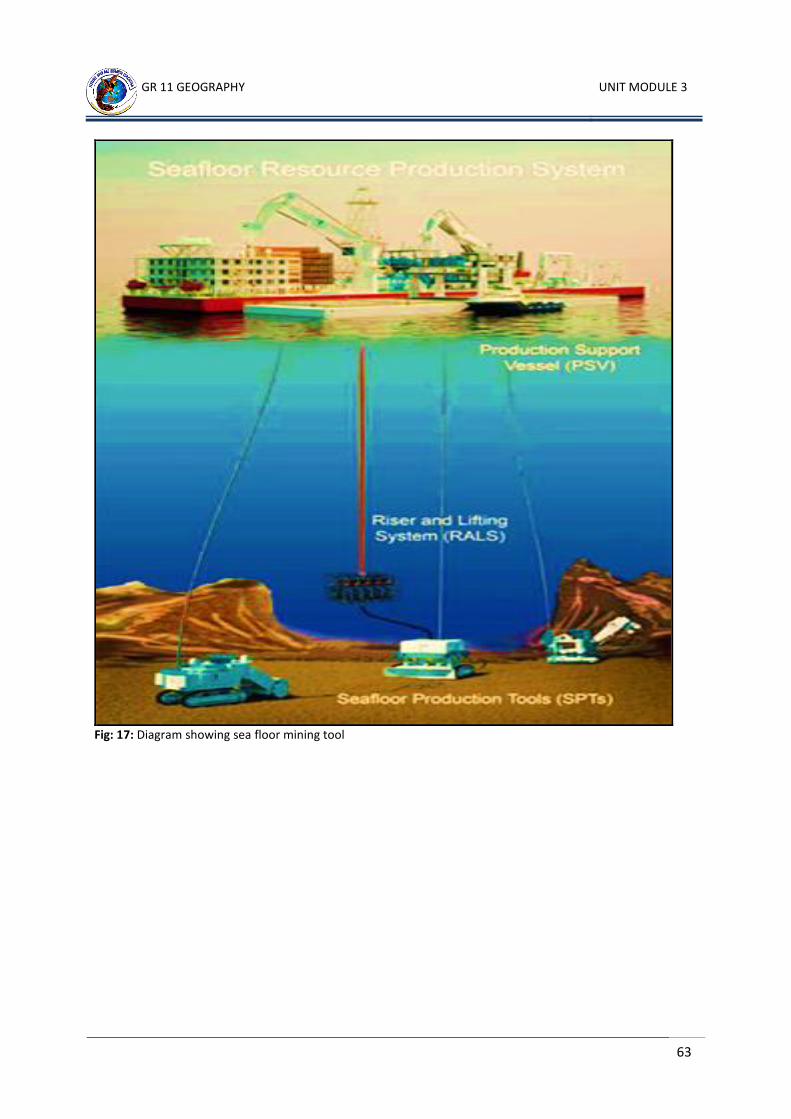
GR 11 GEOGRAPHY UNIT MODULE 3
63
Fig: 17: Diagram showing sea floor mining tool
GR 11 GEOGRAPHY UNIT MODULE 1
64
Learning Activity 11
Define these terms. You can also use a dictionary.
1. Corrosion _____________________________________________________________________
2. Exploitation _____________________________________________________________________
3. Extraction _____________________________________________________________________
4. Filter-feeding _____________________________________________________________________
5. Food web _____________________________________________________________________
6. Mineral _____________________________________________________________________
7. Ocean floor _____________________________________________________________________
8. Oil rig _____________________________________________________________________
9. Pollution _____________________________________________________________________
10. Toxicity _____________________________________________________________________
11. Turbidity _____________________________________________________________________
CHECK YOUR ANSWERS AT THE END OF THE UNIT SUMMARY
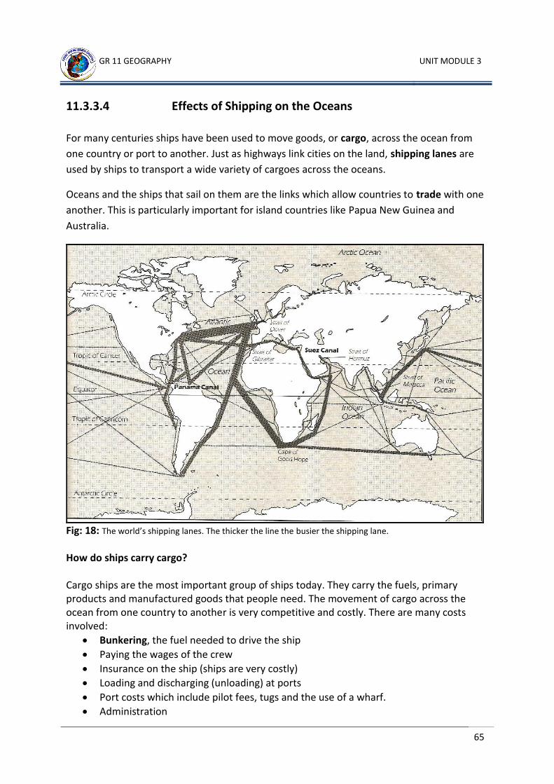
GR 11 GEOGRAPHY UNIT MODULE 3
65
11.3.3.4 Effects of Shipping on the Oceans
For many centuries ships have been used to move goods, or cargo, across the ocean from
one country or port to another. Just as highways link cities on the land, shipping lanes are
used by ships to transport a wide variety of cargoes across the oceans.
Oceans and the ships that sail on them are the links which allow countries to trade with one
another. This is particularly important for island countries like Papua New Guinea and
Australia.
Fig: 18: The world’s shipping lanes. The thicker the line the busier the shipping lane. How do ships carry cargo? Cargo ships are the most important group of ships today. They carry the fuels, primary products and manufactured goods that people need. The movement of cargo across the ocean from one country to another is very competitive and costly. There are many costs involved:
Bunkering, the fuel needed to drive the ship
Paying the wages of the crew
Insurance on the ship (ships are very costly)
Loading and discharging (unloading) at ports
Port costs which include pilot fees, tugs and the use of a wharf.
Administration
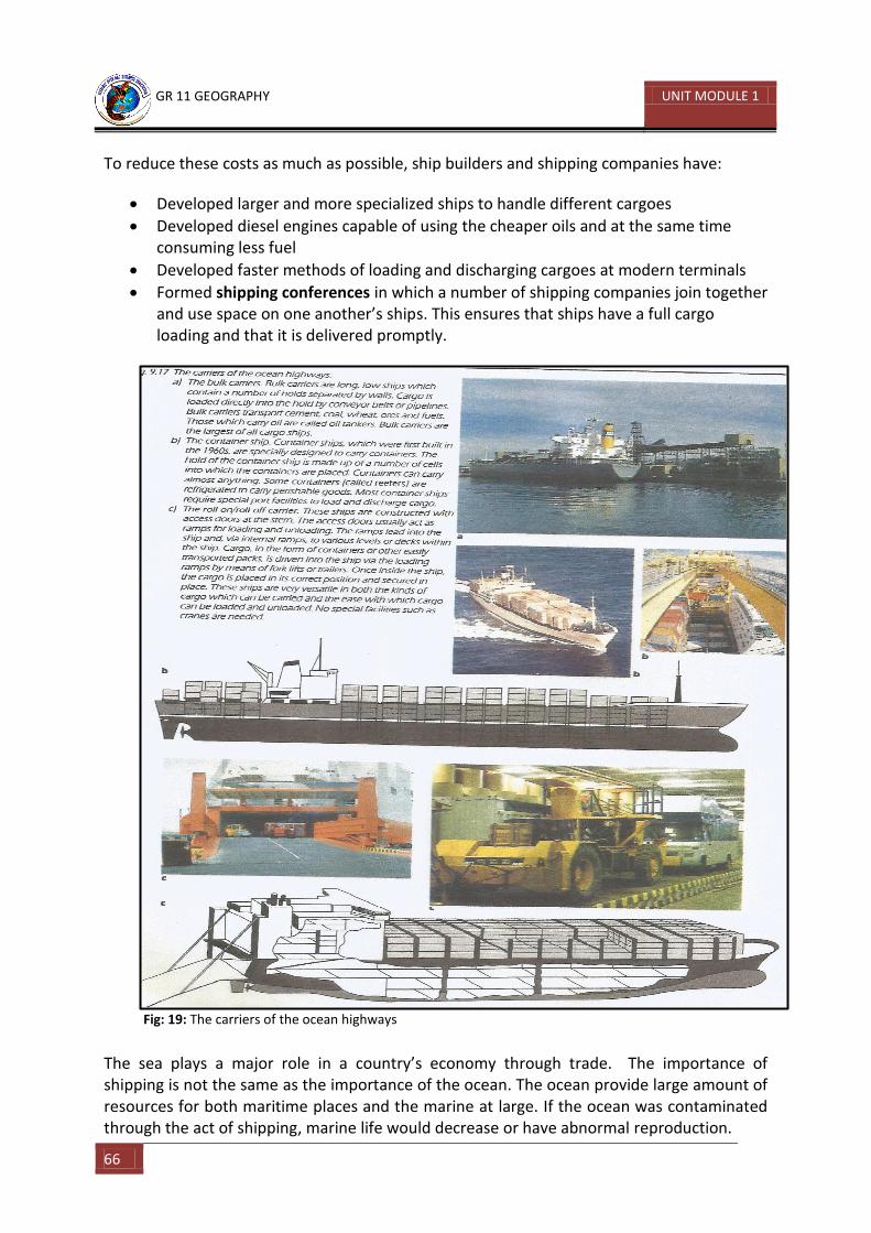
GR 11 GEOGRAPHY UNIT MODULE 1
66
To reduce these costs as much as possible, ship builders and shipping companies have:
Developed larger and more specialized ships to handle different cargoes
Developed diesel engines capable of using the cheaper oils and at the same time consuming less fuel
Developed faster methods of loading and discharging cargoes at modern terminals
Formed shipping conferences in which a number of shipping companies join together and use space on one another’s ships. This ensures that ships have a full cargo loading and that it is delivered promptly.
Fig: 19: The carriers of the ocean highways
The sea plays a major role in a country’s economy through trade. The importance of shipping is not the same as the importance of the ocean. The ocean provide large amount of resources for both maritime places and the marine at large. If the ocean was contaminated through the act of shipping, marine life would decrease or have abnormal reproduction.
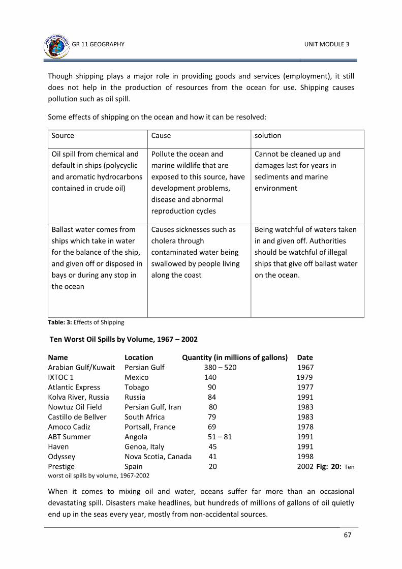
GR 11 GEOGRAPHY UNIT MODULE 3
67
Though shipping plays a major role in providing goods and services (employment), it still
does not help in the production of resources from the ocean for use. Shipping causes
pollution such as oil spill.
Some effects of shipping on the ocean and how it can be resolved:
Source Cause solution
Oil spill from chemical and
default in ships (polycyclic
and aromatic hydrocarbons
contained in crude oil)
Pollute the ocean and
marine wildlife that are
exposed to this source, have
development problems,
disease and abnormal
reproduction cycles
Cannot be cleaned up and
damages last for years in
sediments and marine
environment
Ballast water comes from
ships which take in water
for the balance of the ship,
and given off or disposed in
bays or during any stop in
the ocean
Causes sicknesses such as
cholera through
contaminated water being
swallowed by people living
along the coast
Being watchful of waters taken
in and given off. Authorities
should be watchful of illegal
ships that give off ballast water
on the ocean.
Table: 3: Effects of Shipping
Ten Worst Oil Spills by Volume, 1967 – 2002
Name Location Quantity (in millions of gallons) Date Arabian Gulf/Kuwait Persian Gulf 380 – 520 1967 IXTOC 1 Mexico 140 1979 Atlantic Express Tobago 90 1977 Kolva River, Russia Russia 84 1991 Nowtuz Oil Field Persian Gulf, Iran 80 1983 Castillo de Bellver South Africa 79 1983 Amoco Cadiz Portsall, France 69 1978 ABT Summer Angola 51 – 81 1991 Haven Genoa, Italy 45 1991 Odyssey Nova Scotia, Canada 41 1998 Prestige Spain 20 2002 Fig: 20: Ten
worst oil spills by volume, 1967-2002
When it comes to mixing oil and water, oceans suffer far more than an occasional
devastating spill. Disasters make headlines, but hundreds of millions of gallons of oil quietly
end up in the seas every year, mostly from non-accidental sources.
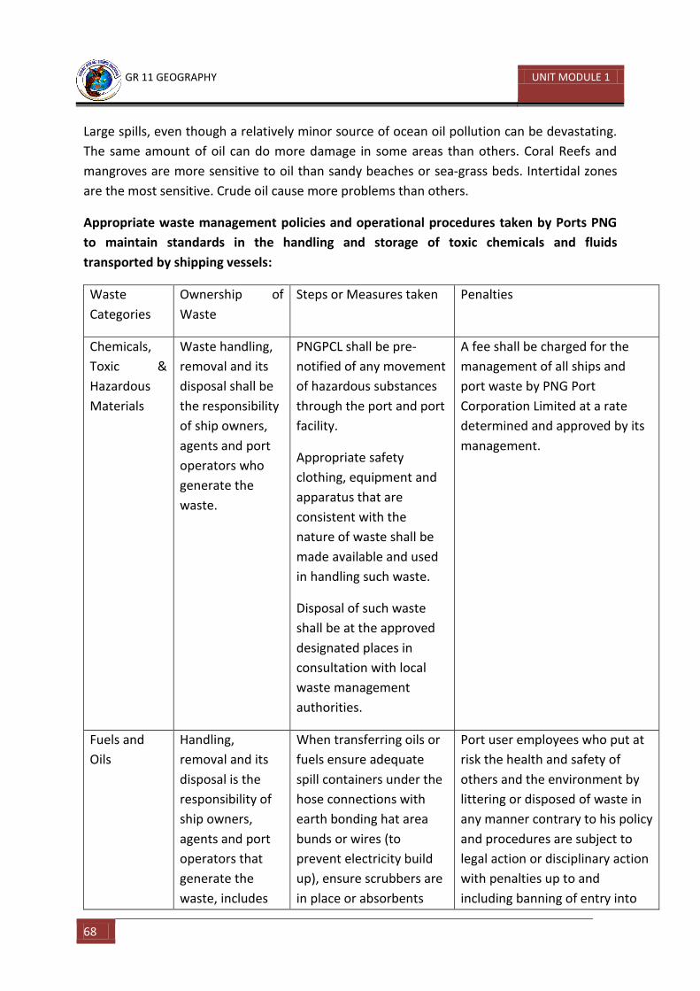
GR 11 GEOGRAPHY UNIT MODULE 1
68
Large spills, even though a relatively minor source of ocean oil pollution can be devastating.
The same amount of oil can do more damage in some areas than others. Coral Reefs and
mangroves are more sensitive to oil than sandy beaches or sea-grass beds. Intertidal zones
are the most sensitive. Crude oil cause more problems than others.
Appropriate waste management policies and operational procedures taken by Ports PNG
to maintain standards in the handling and storage of toxic chemicals and fluids
transported by shipping vessels:
Waste
Categories
Ownership of
Waste
Steps or Measures taken Penalties
Chemicals,
Toxic &
Hazardous
Materials
Waste handling,
removal and its
disposal shall be
the responsibility
of ship owners,
agents and port
operators who
generate the
waste.
PNGPCL shall be pre-
notified of any movement
of hazardous substances
through the port and port
facility.
Appropriate safety
clothing, equipment and
apparatus that are
consistent with the
nature of waste shall be
made available and used
in handling such waste.
Disposal of such waste
shall be at the approved
designated places in
consultation with local
waste management
authorities.
A fee shall be charged for the
management of all ships and
port waste by PNG Port
Corporation Limited at a rate
determined and approved by its
management.
Fuels and
Oils
Handling,
removal and its
disposal is the
responsibility of
ship owners,
agents and port
operators that
generate the
waste, includes
When transferring oils or
fuels ensure adequate
spill containers under the
hose connections with
earth bonding hat area
bunds or wires (to
prevent electricity build
up), ensure scrubbers are
in place or absorbents
Port user employees who put at
risk the health and safety of
others and the environment by
littering or disposed of waste in
any manner contrary to his policy
and procedures are subject to
legal action or disciplinary action
with penalties up to and
including banning of entry into
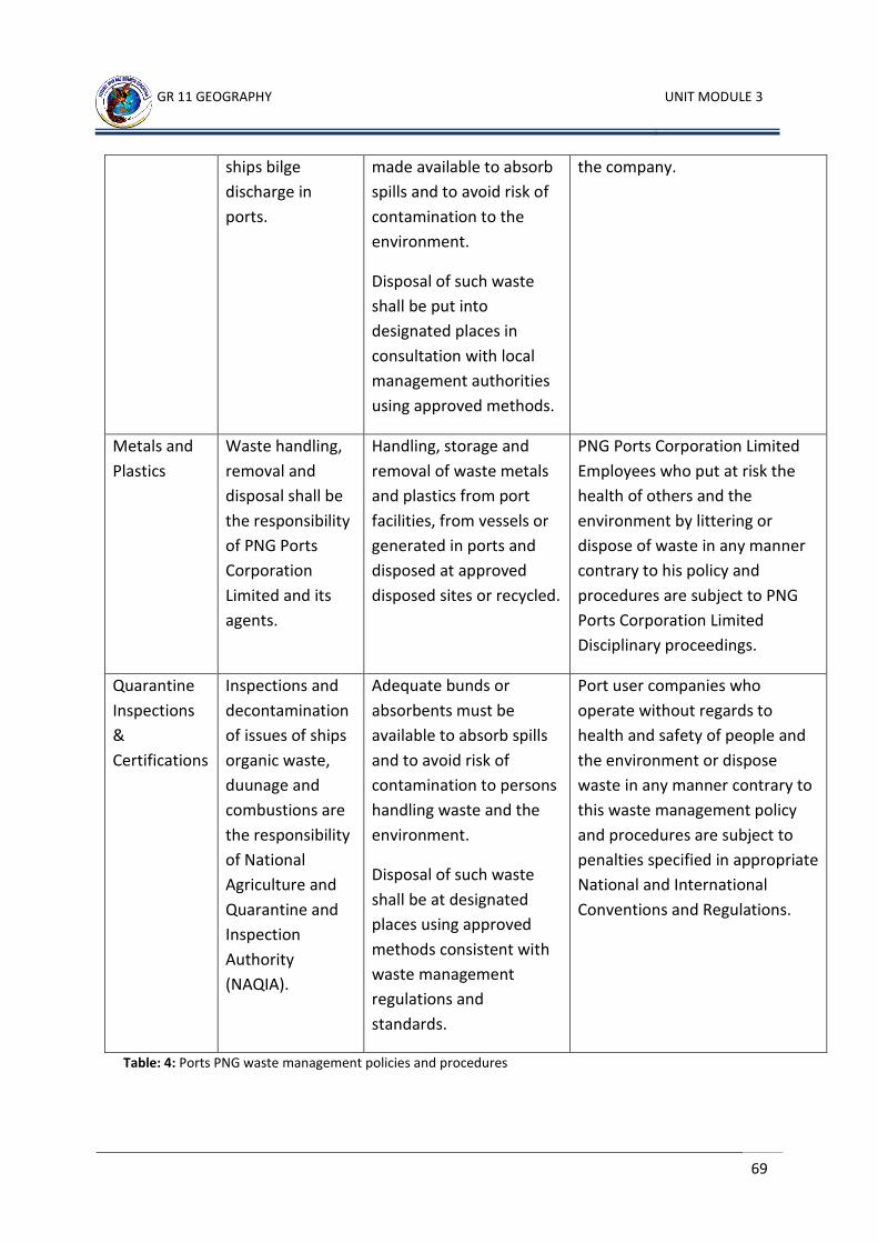
GR 11 GEOGRAPHY UNIT MODULE 3
69
ships bilge
discharge in
ports.
made available to absorb
spills and to avoid risk of
contamination to the
environment.
Disposal of such waste
shall be put into
designated places in
consultation with local
management authorities
using approved methods.
the company.
Metals and
Plastics
Waste handling,
removal and
disposal shall be
the responsibility
of PNG Ports
Corporation
Limited and its
agents.
Handling, storage and
removal of waste metals
and plastics from port
facilities, from vessels or
generated in ports and
disposed at approved
disposed sites or recycled.
PNG Ports Corporation Limited
Employees who put at risk the
health of others and the
environment by littering or
dispose of waste in any manner
contrary to his policy and
procedures are subject to PNG
Ports Corporation Limited
Disciplinary proceedings.
Quarantine
Inspections
&
Certifications
Inspections and
decontamination
of issues of ships
organic waste,
duunage and
combustions are
the responsibility
of National
Agriculture and
Quarantine and
Inspection
Authority
(NAQIA).
Adequate bunds or
absorbents must be
available to absorb spills
and to avoid risk of
contamination to persons
handling waste and the
environment.
Disposal of such waste
shall be at designated
places using approved
methods consistent with
waste management
regulations and
standards.
Port user companies who
operate without regards to
health and safety of people and
the environment or dispose
waste in any manner contrary to
this waste management policy
and procedures are subject to
penalties specified in appropriate
National and International
Conventions and Regulations.
Table: 4: Ports PNG waste management policies and procedures
GR 11 GEOGRAPHY UNIT MODULE 1
70
Activity 12
1. What are two negative effects of shipping on the oceans? 1) _______________________________________________________________
_______________________________________________________________
2) ______________________________________________________________________________________________________________________________
2. What is a shipping lane? _____________________________________________________________________
_____________________________________________________________________
Refer to the map on page 65 to answer questions 3 to 5.
3. Which ocean has the most shipping lanes? _____________________________________________________________________
4. Which two areas of the world are linked by the busiest shipping lanes? __________________________________________________________________________________________________________________________________________
5. Which two oceans does the Suez Canal link? ____________________________ and ____________________________
6. What is bunkering? __________________________________________________________________________________________________________________________________________
7. What does the word trade mean? __________________________________________________________________________________________________________________________________________
CHECK YOUR ANSWERS AT THE END OF THE UNIT SUMMARY
GR 11 GEOGRAPHY UNIT MODULE 3
71
11.3.3.5 Impact of Tourism on Coastal Regions and Islands Tourism is defined as the business activity connected with providing accommodation and
entertainment for people who are visiting a particular place for pleasure, business or
research and education.
Pacific Islanders have adopted many elements of Western lifestyles however, a few rural
isolated places still have minimal western influences. For example, interior of islands such as
Papua New Guinea and Fijis’ Viti Levu and tiny remote islands. In recent years, rural
residents, especially those in coastal villages have been influenced by a growing number of
tourists. Western efforts include improved programmes in health and education – the
introduction of agriculture and fishing techniques and better transportation and
telecommunication networks.
Tourism has become one of the major income earners and employers of local workers in the
Pacific. Fiji attracts more tourists than any other Pacific island nations, with 34,000 visitors in
1996. In 1989 tourism surpassed sugar as Fiji’s prime source of foreign income and French
Polynesia was the second most popular tourist destination. As with trade goods, tourists visit
the Pacific islands from former colonial powers and nearby large countries.
In Papua New Guinea, more than 50,000 foreigners visit the country each year. In 2002, 62%
of them came to conduct business, 29% for holidays, and 9% to visit friends and family. (PNG
Fact Book, 3th Edition; Rannells and Matatier)
Positive impacts of tourism
Cultural ties and mutual understanding is strengthened
Provide foreign currency to boost trade
More jobs or employment
Provision of more services
Stimulates economic development
Preservation of historical sites.
Ecotourism provides more awareness on the need to use resources sustainably
Negative impacts of tourism
Loss of cultural identity
Pressure on resources such as water
Traffic congestion and overcrowding
Increased waste disposal
Disruption of lifestyle of local people
Benefits of tourism not always evenly shared among people.
GR 11 GEOGRAPHY UNIT MODULE 1
72
Most tourist facilities are owned by foreigners and much of the profit from tourism leaves
the Pacific. Furthermore, many products used for tourism such as food, drinks, are often
imported and further drain already poor economies.
Tourist Destinations
Some of the scenic features and sites that tourists visit as they travel from country to
country:
Important historical, art and cultural preservation areas such as the Great Wall of China
Very spectacular and attractive places such as the Ayers Rock in Australia or the Grant Canyon in USA
Coral reefs and lagoons for fun and recreational purposes
Experiencing the Art, Culture and Tradition of people such as European tourists attending the Independence shows in parts of PNG
Important historical cities such as Paris, London, Rome, Jerusalem
Places and remains of war and war relics such as Rabaul, Wewak and the Kokoda trail in Papua New Guinea
Important national heritage and preservation sites such as the Great Barrier Reef in Queensland
GR 11 GEOGRAPHY UNIT MODULE 3
73
11.3.3.6 Causes and Effects of Depleting Ocean Resources
What is depletion?
Depletion basically means that when something is reduced by a large amount so that there
is not enough left for later use. For example, ozone depletion or the depletion of fish stocks
which can lead to a shortage of certain species of fish.
Ocean Resources
The resources of the ocean can be divided into:
Food Resources – For example, fish, prawns, lobsters, crabs, shrimp, octopus, all those edible marine life that is harvested from the oceans
Mineral and Energy Resources – For example, manganese nodules, oil and gas, those energy and minerals that are mined off-shore
Recreational resources – For example, tools and equipment needed for fishing, diving, skiing and so forth.
Causes of depleting ocean resources
The two major causes of the depletion of ocean resources are natural causes and manmade
causes. An example of a natural cause is the issue of climate change and global warming.
Examples of manmade causes are
Pollution
Overpopulation
Unsustainable fishing practices such as dynamite fishing
This further results in habitat destruction and loss of marine biodiversity. This eventually
leads to implications such as migration of fish species or decrease in number of fish species,
which in turn is a threat to food security. In addition, some species eventually become
extinct.
Causes of Ocean Pollution
Some of the major causes of pollution in the oceans are activities such as:
Overfishing and the use of explosives, chemicals and dynamites for fast catches of fish
Dumping of mine waste and mine tailings into the continental shelves
Accumulated untreated sewage disposals
Deep sea mineral exploration and mining
GR 11 GEOGRAPHY UNIT MODULE 1
74
Most of these activities have severe impacts on the marine ecosystems and wildlife and
depletes ocean resources.
Impact on the Marine Ecosystem
Affects the formation of coral polyps, which in turn affects the formation of most marine organisms
Algae blooms, the expansion and spread in the volume of algae, bacteria, phytoplankton in coastal areas, causing the spread of water borne diseases such as cholera, typhoid, and diahorrea in coastal communities.
Increase in chemical composition of the sea water affect the reproduction of fish populations
Impact on coastal inhabitants and island communities
Affect their source of protein supply as a result of a decrease in fish population and other sources of sea food.
Develop respiratory and intestinal diseases through chemical poisoning by consuming fish that contains the poison or toxin in its system.
GR 11 GEOGRAPHY UNIT MODULE 3
75
UNIT SUMMARY
In this unit of work you have learned about the importance of the oceans, and the marine ecosystems and habitats and most importantly the ocean as a resource. You have also learned to:
Know about the impact of marine pollution
Know about possible effects of the exploitation of marine resources
Know about fisheries and conservation
Know about the exploration and exploitation of underwater oil and gas reserves
Know about coastal protection policies
Know the role of ocean in possible global warming and climate change
Understand past and present global environment changes as well as possible future changes.
GR 11 GEOGRAPHY UNIT MODULE 1
76
ANSWERS TO LEARNING ACTIVITIES 1-12
Activity 1
1. Continents:
a. Europe
b. Asia
c. North America
d. South America
e. Africa
f. Antarctica
2. Oceans:
A. Pacific Ocean
B. Atlantic Ocean
C. Indian Ocean
D. Arctic Ocean
3. Seas:
E. Mediterranean Sea
F. Red Sea
G. Arabian Sea
H. Sea of Japan
I. Caribbean Sea
J. South China Sea
K. Tasman Sea
L. Coral Sea
M. Timor Sea
N. North Sea
O. Baltic Sea
4. Bays:
P. Bay of Biscay
Q. Hudson Bay
R. Bay of Bengal
5. Gulfs:
S. Gulf of Guinea
T. The Persian Gulf
U. Gulf of Carpentaria
V. Gulf of Mexico
6. Straits:
W. Bering Strait
X. Torres Strait
Y. Bass Strait
Z. Strait of Gibraltar
7. The Oceans of the World. Students to label the map.
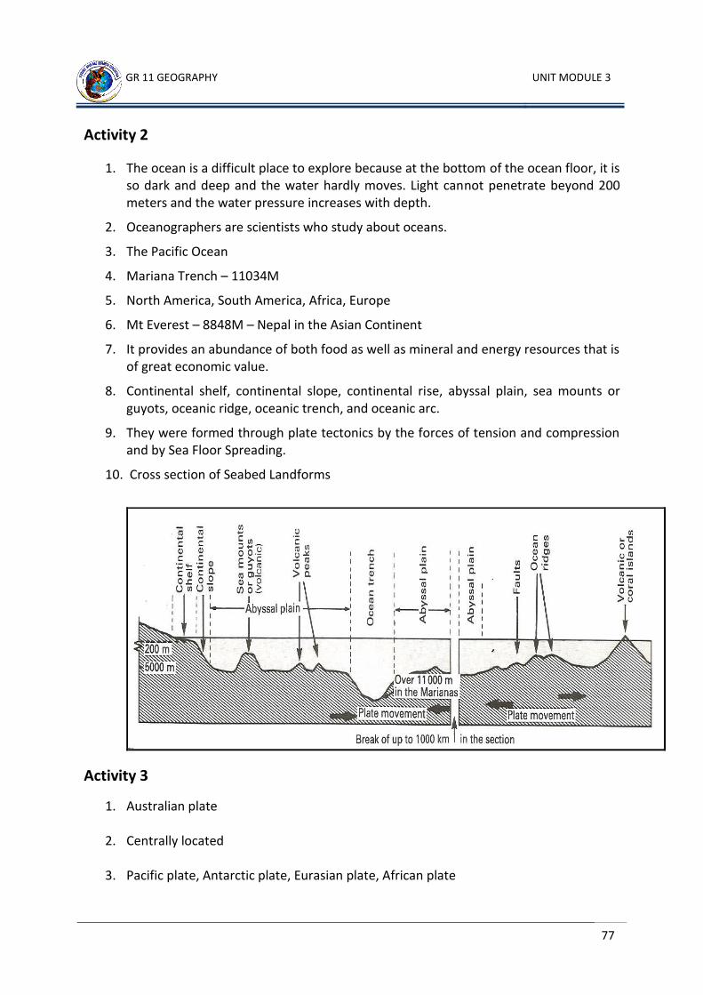
GR 11 GEOGRAPHY UNIT MODULE 3
77
Activity 2
1. The ocean is a difficult place to explore because at the bottom of the ocean floor, it is so dark and deep and the water hardly moves. Light cannot penetrate beyond 200 meters and the water pressure increases with depth.
2. Oceanographers are scientists who study about oceans.
3. The Pacific Ocean
4. Mariana Trench – 11034M
5. North America, South America, Africa, Europe
6. Mt Everest – 8848M – Nepal in the Asian Continent
7. It provides an abundance of both food as well as mineral and energy resources that is of great economic value.
8. Continental shelf, continental slope, continental rise, abyssal plain, sea mounts or guyots, oceanic ridge, oceanic trench, and oceanic arc.
9. They were formed through plate tectonics by the forces of tension and compression and by Sea Floor Spreading.
10. Cross section of Seabed Landforms
Activity 3
1. Australian plate
2. Centrally located
3. Pacific plate, Antarctic plate, Eurasian plate, African plate
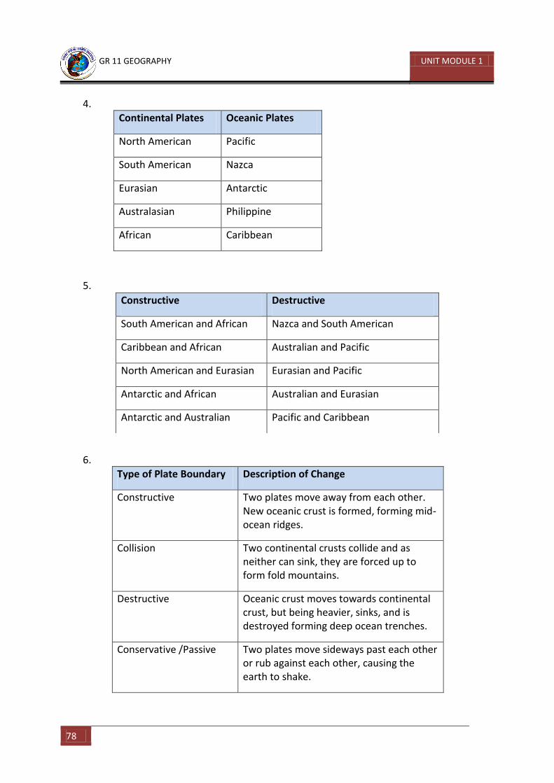
GR 11 GEOGRAPHY UNIT MODULE 1
78
4.
Continental Plates Oceanic Plates
North American Pacific
South American Nazca
Eurasian Antarctic
Australasian Philippine
African Caribbean
5.
6.
Type of Plate Boundary Description of Change
Constructive Two plates move away from each other. New oceanic crust is formed, forming mid-ocean ridges.
Collision Two continental crusts collide and as neither can sink, they are forced up to form fold mountains.
Destructive Oceanic crust moves towards continental crust, but being heavier, sinks, and is destroyed forming deep ocean trenches.
Conservative /Passive Two plates move sideways past each other or rub against each other, causing the earth to shake.
Constructive Destructive
South American and African Nazca and South American
Caribbean and African Australian and Pacific
North American and Eurasian Eurasian and Pacific
Antarctic and African Australian and Eurasian
Antarctic and Australian Pacific and Caribbean
GR 11 GEOGRAPHY UNIT MODULE 3
79
Activity 4
1. Horizontal movements are called currents and vertical movements are called tides. Currents are caused by prevailing winds while tides are caused by the rotational effect of the earth and the gravitational pull of the sun, moon and the earth on each other.
2. Sea water is less dense when its level of salinity is high, and the upwelling of bottom water and the lowering of surface water is made easier. The prevailing wind systems help to power the flow of surface currents from areas of high temperature to areas of low temperature and vice versa.
3. Warm currents flow on the western side of continents. They flow from a south westerly direction towards a north easterly direction in the northern hemisphere.
4. West Wind Drift (Peruvian current), Cold Current – Somewhere towards the Polynesian Islands in the Pacific Ocean.
5. Tide is the vertical movement of ocean water. Tides are caused by the gravitational pull of the moon on the earth’s ocean surface.
6. A Spring Tide usually has a high tidal range. High tides are usually higher and low tides are usually lower during new moon and full moon, when the gravitational pull of the moon, earth and sun are stronger, because they are all in a straight line and are pulling at each other.
7. a. Gyres – giant paths in which ocean water circulate
b. Spring Tide – high tides are very high and low tides are very low at new moon
and full moon.
c. Neap Tide – high tides are not very high and low tides are not very low during
half moon
d. Tidal Range – difference between high tide and low tide
e. Inter-tidal Zone – a part of the shore line which is covered by sea at high tide
and not covered by sea at low tide
f. Estuary – a wide part of a river where it flows into the sea
Activity 5
1. Word Definitions: a. Marine ecosystem – community of living things found in the oceans
b. Benthic life – life forms attached to the sea floor
c. Pelagic life – life forms that are free swimming and flows with the current
GR 11 GEOGRAPHY UNIT MODULE 1
80
d. Photic zone – the upper level of the ocean where sunlight can penetrate
below the surface
e. Plankton – microscopic plant and animal life in the ocean
f. Phytoplankton – microscopic plant life
g. Zooplankton –microscopic animal life
h. Nektonic – free swimming pelagic life
i. Food chain – a series of living creatures in which each type of creature feeds
on the one below it in the series
j. Food web – a combination of more than one food chains
2. A fishing method where fishermen use explosives and chemicals to harvest fish.
3. Sample Answers: prawns, squid, crabs, lobsters
4. Sustainable use of the ocean resources means ecofriendly ways by which the marine ecosystem is not harmed or damaged by man’s activities. Unsustainable use of the ocean resources means ways and methods that harms and damages the marine environment.
Activity 6
1. The oceans are such a vast environment that many people have looked upon them as a dumping ground.
2. We can be affected when we eat fish and other sea food that contains the toxins and poison from the waste that has been dumped into the oceans.
3. An oil slick occurs when the spilt oil drifts and spreads across the ocean surface.
4. From:
Tankers colliding and running aground at sea
Oil spills which occur when oil is being discharged into storage areas near refineries located in ports or bays
5. Damages such as:
The oil sticks on surface feeding birds and stops them from flying and they eventually die of hunger and cold
All life forms on the surface are either killed or severely damaged by the toxic effects of oil
Affects the tourism industry-especially beach resorts
6. Eutrophication is the depletion of oxygen in sea water. It is the process by which the ocean becomes rich in dissolved nutrients from fertilizers or sewage. This encourages
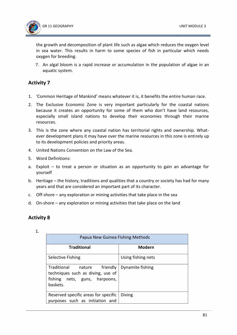
GR 11 GEOGRAPHY UNIT MODULE 3
81
the growth and decomposition of plant life such as algae which reduces the oxygen level in sea water. This results in harm to some species of fish in particular which needs oxygen for breeding.
7. An algal bloom is a rapid increase or accumulation in the population of algae in an aquatic system.
Activity 7
1. ‘Common Heritage of Mankind’ means whatever it is, it benefits the entire human race.
2. The Exclusive Economic Zone is very important particularly for the coastal nations because it creates an opportunity for some of them who don’t have land resources, especially small island nations to develop their economies through their marine resources.
3. This is the zone where any coastal nation has territorial rights and ownership. What- ever development plans it may have over the marine resources in this zone is entirely up to its development policies and priority areas.
4. United Nations Convention on the Law of the Sea.
5. Word Definitions:
a. Exploit – to treat a person or situation as an opportunity to gain an advantage for yourself
b. Heritage – the history, traditions and qualities that a country or society has had for many years and that are considered an important part of its character.
c. Off-shore – any exploration or mining activities that take place in the sea
d. On-shore – any exploration or mining activities that take place on the land
Activity 8
1.
Papua New Guinea Fishing Methods
Traditional Modern
Selective Fishing Using fishing nets
Traditional nature friendly techniques such as diving, use of fishing nets, guns, harpoons, baskets.
Dynamite fishing
Reserved specific areas for specific purposes such as initiation and
Diving
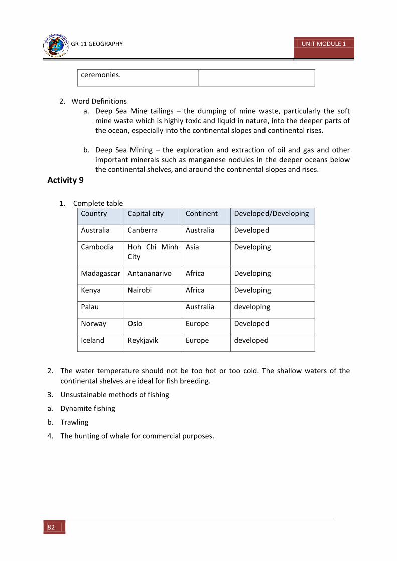
GR 11 GEOGRAPHY UNIT MODULE 1
82
ceremonies.
2. Word Definitions
a. Deep Sea Mine tailings – the dumping of mine waste, particularly the soft mine waste which is highly toxic and liquid in nature, into the deeper parts of the ocean, especially into the continental slopes and continental rises.
b. Deep Sea Mining – the exploration and extraction of oil and gas and other important minerals such as manganese nodules in the deeper oceans below the continental shelves, and around the continental slopes and rises.
Activity 9
1. Complete table
Country Capital city Continent Developed/Developing
Australia Canberra Australia Developed
Cambodia Hoh Chi Minh City
Asia Developing
Madagascar Antananarivo Africa Developing
Kenya Nairobi Africa Developing
Palau Australia developing
Norway Oslo Europe Developed
Iceland Reykjavik Europe developed
2. The water temperature should not be too hot or too cold. The shallow waters of the continental shelves are ideal for fish breeding.
3. Unsustainable methods of fishing
a. Dynamite fishing
b. Trawling
4. The hunting of whale for commercial purposes.
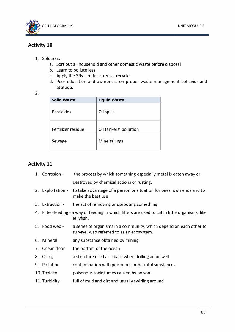
GR 11 GEOGRAPHY UNIT MODULE 3
83
Activity 10
1. Solutions a. Sort out all household and other domestic waste before disposal b. Learn to pollute less c. Apply the 3Rs – reduce, reuse, recycle d. Peer education and awareness on proper waste management behavior and
attitude. 2.
Activity 11
1. Corrosion - the process by which something especially metal is eaten away or
destroyed by chemical actions or rusting.
2. Exploitation - to take advantage of a person or situation for ones’ own ends and to make the best use
3. Extraction - the act of removing or uprooting something.
4. Filter-feeding - a way of feeding in which filters are used to catch little organisms, like jellyfish.
5. Food web - a series of organisms in a community, which depend on each other to survive. Also referred to as an ecosystem.
6. Mineral any substance obtained by mining.
7. Ocean floor the bottom of the ocean
8. Oil rig a structure used as a base when drilling an oil well
9. Pollution contamination with poisonous or harmful substances
10. Toxicity poisonous toxic fumes caused by poison
11. Turbidity full of mud and dirt and usually swirling around
Solid Waste Liquid Waste
Pesticides
Oil spills
Fertilizer residue
Oil tankers’ pollution
Sewage
Mine tailings
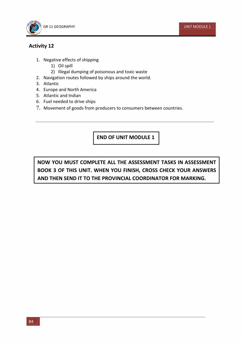
GR 11 GEOGRAPHY UNIT MODULE 1
84
Activity 12
1. Negative effects of shipping 1) Oil spill 2) Illegal dumping of poisonous and toxic waste
2. Navigation routes followed by ships around the world. 3. Atlantic 4. Europe and North America 5. Atlantic and Indian 6. Fuel needed to drive ships
7. Movement of goods from producers to consumers between countries.
END OF UNIT MODULE 1
NOW YOU MUST COMPLETE ALL THE ASSESSMENT TASKS IN ASSESSMENT
BOOK 3 OF THIS UNIT. WHEN YOU FINISH, CROSS CHECK YOUR ANSWERS
AND THEN SEND IT TO THE PROVINCIAL COORDINATOR FOR MARKING.
GR 11 GEOGRAPHY UNIT MODULE 3
85
Bibliography or References
1. P.C.H. RANASINGHE (2005) An Introduction to Geography. UPNG Printing, Papua New
Guinea.
2. R.B. BUNNET (1965) Physical Geography in Diagrams. Longman ,Pte Ltd, Singapore
3. STAN SQUIRE (1988) Interactions in Physical Geography Today. Oxford University
Press, Melbourne, Australia
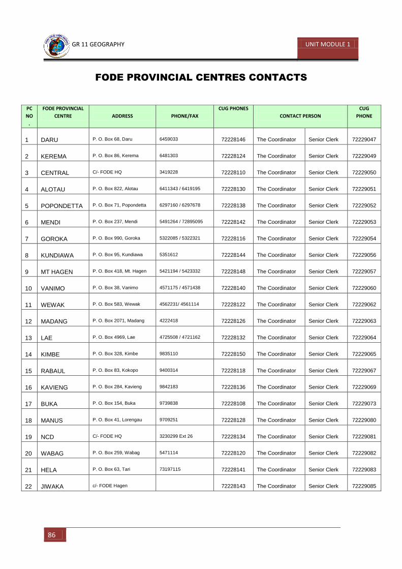
GR 11 GEOGRAPHY UNIT MODULE 1
86
FODE PROVINCIAL CENTRES CONTACTS
PC
NO
.
FODE PROVINCIAL
CENTRE
ADDRESS
PHONE/FAX
CUG PHONES
CONTACT PERSON
CUG
PHONE
1 DARU P. O. Box 68, Daru 6459033 72228146 The Coordinator Senior Clerk 72229047
2 KEREMA P. O. Box 86, Kerema 6481303 72228124 The Coordinator Senior Clerk 72229049
3 CENTRAL C/- FODE HQ 3419228 72228110 The Coordinator Senior Clerk 72229050
4 ALOTAU P. O. Box 822, Alotau 6411343 / 6419195 72228130 The Coordinator Senior Clerk 72229051
5 POPONDETTA P. O. Box 71, Popondetta 6297160 / 6297678 72228138 The Coordinator Senior Clerk 72229052
6 MENDI P. O. Box 237, Mendi 5491264 / 72895095 72228142 The Coordinator Senior Clerk 72229053
7 GOROKA P. O. Box 990, Goroka 5322085 / 5322321 72228116 The Coordinator Senior Clerk 72229054
8 KUNDIAWA P. O. Box 95, Kundiawa 5351612 72228144 The Coordinator Senior Clerk 72229056
9 MT HAGEN P. O. Box 418, Mt. Hagen 5421194 / 5423332 72228148 The Coordinator Senior Clerk 72229057
10 VANIMO P. O. Box 38, Vanimo 4571175 / 4571438 72228140 The Coordinator Senior Clerk 72229060
11 WEWAK P. O. Box 583, Wewak 4562231/ 4561114 72228122 The Coordinator Senior Clerk 72229062
12 MADANG P. O. Box 2071, Madang 4222418 72228126 The Coordinator Senior Clerk 72229063
13 LAE P. O. Box 4969, Lae 4725508 / 4721162 72228132 The Coordinator Senior Clerk 72229064
14 KIMBE P. O. Box 328, Kimbe 9835110 72228150 The Coordinator Senior Clerk 72229065
15 RABAUL P. O. Box 83, Kokopo 9400314 72228118 The Coordinator Senior Clerk 72229067
16 KAVIENG P. O. Box 284, Kavieng 9842183 72228136 The Coordinator Senior Clerk 72229069
17 BUKA P. O. Box 154, Buka 9739838 72228108 The Coordinator Senior Clerk 72229073
18 MANUS P. O. Box 41, Lorengau 9709251 72228128 The Coordinator Senior Clerk 72229080
19 NCD C/- FODE HQ 3230299 Ext 26 72228134 The Coordinator Senior Clerk 72229081
20 WABAG P. O. Box 259, Wabag 5471114 72228120 The Coordinator Senior Clerk 72229082
21 HELA P. O. Box 63, Tari 73197115 72228141 The Coordinator Senior Clerk 72229083
22 JIWAKA c/- FODE Hagen 72228143 The Coordinator Senior Clerk 72229085
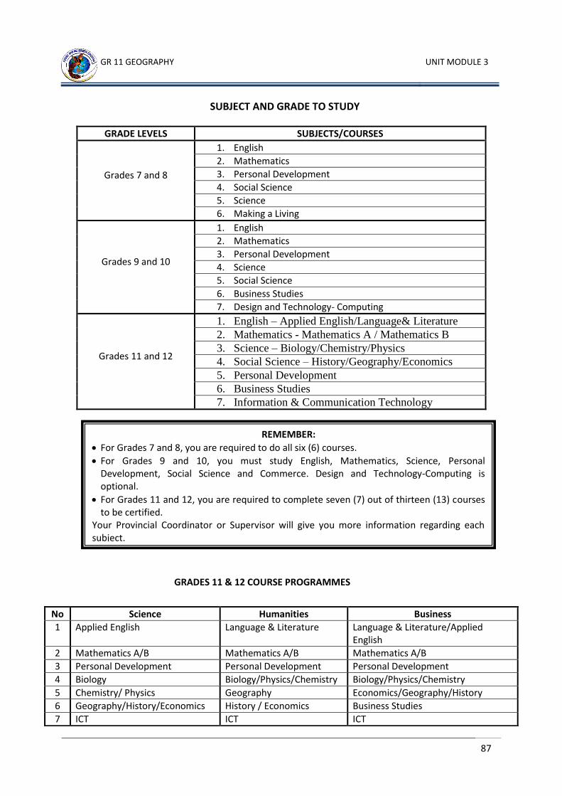
GR 11 GEOGRAPHY UNIT MODULE 3
87
SUBJECT AND GRADE TO STUDY
GRADE LEVELS SUBJECTS/COURSES
Grades 7 and 8
1. English
2. Mathematics
3. Personal Development
4. Social Science
5. Science
6. Making a Living
Grades 9 and 10
1. English
2. Mathematics
3. Personal Development
4. Science
5. Social Science
6. Business Studies
7. Design and Technology- Computing
Grades 11 and 12
1. English – Applied English/Language& Literature
2. Mathematics - Mathematics A / Mathematics B
3. Science – Biology/Chemistry/Physics
4. Social Science – History/Geography/Economics
5. Personal Development
6. Business Studies
7. Information & Communication Technology
GRADES 11 & 12 COURSE PROGRAMMES
No Science Humanities Business
1 Applied English Language & Literature Language & Literature/Applied English
2 Mathematics A/B Mathematics A/B Mathematics A/B
3 Personal Development Personal Development Personal Development
4 Biology Biology/Physics/Chemistry Biology/Physics/Chemistry
5 Chemistry/ Physics Geography Economics/Geography/History
6 Geography/History/Economics History / Economics Business Studies
7 ICT ICT ICT
REMEMBER:
For Grades 7 and 8, you are required to do all six (6) courses.
For Grades 9 and 10, you must study English, Mathematics, Science, Personal Development, Social Science and Commerce. Design and Technology-Computing is optional.
For Grades 11 and 12, you are required to complete seven (7) out of thirteen (13) courses to be certified.
Your Provincial Coordinator or Supervisor will give you more information regarding each subject.
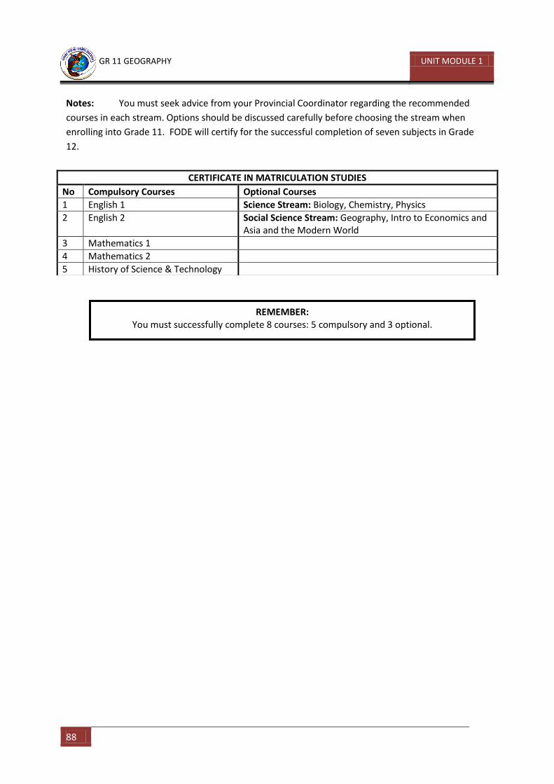
GR 11 GEOGRAPHY UNIT MODULE 1
88
Notes: You must seek advice from your Provincial Coordinator regarding the recommended
courses in each stream. Options should be discussed carefully before choosing the stream when
enrolling into Grade 11. FODE will certify for the successful completion of seven subjects in Grade
12.
CERTIFICATE IN MATRICULATION STUDIES
No Compulsory Courses Optional Courses
1 English 1 Science Stream: Biology, Chemistry, Physics
2 English 2 Social Science Stream: Geography, Intro to Economics and Asia and the Modern World
3 Mathematics 1
4 Mathematics 2
5 History of Science & Technology
REMEMBER: You must successfully complete 8 courses: 5 compulsory and 3 optional.