gpw vision project report · 2019-04-29 · 1.0 draft gpw vision report 10 october 2013 2.0 draft...
TRANSCRIPT


2
GPW Vision ‐ Project Report V3.0

3
GPW Vision ‐ Project Report V3.0
Revision No. Description Date
1.0 Draft GPW Vision Report 10 October 2013
2.0 Draft GPW Vision Report 20 November 2013
3.0 Final GPW Vision Report 10 December 2013
Trim Reference: Document No Z13/251956, Container PJ‐1412
ACKNOWLEDGEMENTS Cover page photomontage – Patrick O'Carrigan and Partners, Architects GPW Route photos – WCC Landscape Architect Section, Design and Technical Services (D&TS) Draft Masterplan plans, sections, images ‐ WCC Landscape Architect Section, D&TS Graphic Design – WCC Marketing Section Draft Signage Strategy – WCC Marketing Section Stage One Plans – Northrop Consulting Engineers, Footprint Sustainable Engineering

4
GPW Vision ‐ Project Report V3.0
CONTENTS
PROJECT INTRODUCTION Page 5
o Background
o Scope
o Benefits of the Grand Pacific Walk
o Project Approach
o Strategic Alignment
o Stakeholders
THE GRAND PACIFIC WALK ROUTE Page 8
o Northern Section – Royal National Park to Thirroul
o Central Section ‐ Thirroul to Wollongong
o Southern Section – Wollongong to Lake Illawarra
ROUTE INVESTIGATION PHASE Page 15
o Site Analysis
o Engagement Report
o Pedestrian and Cycle Survey and Analysis
o Stage One Safety Audit
o Economic Impact Assessment
DRAFT MASTERPLAN Page 21
o Draft Masterplan Components
o Typical Path Arrangements
o Nodal Areas – ‘Picnic Clusters’
o Placemaking
o Furniture and Materials
o Signage Strategy
o Marketing Material
STAGE ONE IMPLEMENTATION Page 30
o Costed Concept Plan
o Stoney Creek Bridge
o Coalcliff Station Precinct

5
GPW Vision ‐ Project Report V3.0
THE GRAND PACIFIC WALK VISION REPORT
PROJECT INTRODUCTION
BACKGROUND
The coastal route from Wollongong to southern Sydney is one of the most scenic in the
world. Recently, the magnificent quality of this route has been highlighted by the launch of
the ‘Grand Pacific Drive’ (GPD) and promoted both locally and internationally. The focus of
the GPD has been travel by car, with the delights of that mode of travel, particularly on the
sweeping bends of the Seacliff Bridge, accentuated in advertising and information about the
route.
In drawing the community’s attention to the route and that travel mode, the stark contrast
of infrastructure provision for vehicles in comparison to that provided for pedestrians and
cyclists has also been brought to the fore, particularly between Stanwell Park and Coalcliff.
Building on the momentum of the GPD, Council endorsed the creation of the Grand Pacific
Walk (GPW) in 2012, following the GPD route from the Royal National Park through
Wollongong CBD, and on to Lake Illawarra.
SCOPE
The coastline of the Wollongong LGA creates a linear north‐south corridor comprised of a
series of villages, small to medium commercial areas, and the Wollongong CBD. The vision
of the GPW project is to create a safe route for both pedestrians and cyclists for the entire
60km length, taking advantage of the numerous spectacular outlooks and areas of high
scenic quality.
In addition, facilities are proposed to be provided at regular intervals including bicycle
parking, car parking, rest areas, viewing areas, water and guidance to local attractions and
cafes. The nominated route will form a pedestrian and cyclist spine that will ultimately link
the coastal villages and towns, the Wollongong CBD, and the inter‐suburban bicycle routes
of the Wollongong Bike Plan.
BENEFITS OF THE GRAND PACIFIC WALK
The currently available infrastructure is variable from non‐existent or narrow access ways
adjacent to the road, to the high quality facilities provided in Wollongong City’s Blue Mile
which include full width shareways, seating, shelter, water and food outlets, and beach
facilities.

6
GPW Vision ‐ Project Report V3.0
Developing the GPW has the potential to deliver benefits in health and wellbeing for the
community, environmental benefits through the provision of an alternative transport mode,
and improvements in facilities for both the local community and visitors
Once complete, the GPW will benefit these communities by:
Improving connections between communities
Encouraging healthy lifestyles
Creating tourism and economic benefits
Providing alternative transport routes
Reducing the environmental and health impacts of motorised transport
Improving the environmental condition of sections of the coastal zone.
The development of the Grand Pacific Walk project will also allow the coordination and
realisation of state and regional cycle / pedestrian route planning aspirations. It will allow
key stakeholders to make informed decisions in relation to route confirmation, necessary
supporting infrastructure, approvals, and budget allocations. Importantly it will provide a
realistic, costed concept plan that can be used repeatedly to make the proposal clear to
stakeholders, excite interest, and allow the pursuit of funding opportunities.
PROJECT APPROACH
The GPW project is being developed in two parallel actions:
1. THE GRAND PACIFIC WALK MASTERPLAN –
Royal National Park to Lake Illawarra
The masterplan includes the development of the following:
an overview masterplan that establishes a unified design approach
typical design solutions for the provision of adequate width and separation from
vehicles
unique graphic style and documentation for community consultation, signage, and
communication with government authorities
the definition of necessary upgrade works along the route such as seating, viewing
areas and way‐finding signage.
2. THE GRAND PACIFIC WALK STAGE ONE IMPLEMENTATION–
Station Street Stanwell Park to Paterson Road Coalcliff.
This section of the GPW is considered a high priority by Council due to the steep and
sometimes unstable land, narrow roads and a lack of provisions for pedestrians and cyclists.
As detailed later in this report, design development is proceeding with both an overall
costed concept plan for the entire segment, and detailed design for the Stoney Creek and
Coalcliff Station area.
7
GPW Vision ‐ Project Report V3.0
STRATEGIC ALIGNMENT
The Grand Pacific Walk links into the community and Council’s goals as part of the
Wollongong 2022: Community Strategic Plan. It helps to achieve the goals of creating a
‘healthy community in a liveable city’, and having ‘sustainable, affordable and accessible
transport’. The project also addresses Council’s Delivery Program 2012‐17 goal to ‘improve
the connectivity of the Local Government Area through the upgrade of our network of
footpaths and cycleways’.
STAKEHOLDERS
The primary external stakeholder in this project is NSW Roads & Maritime Service (RMS) as
the approval authority and landowner. The project is of great interest to the local
community however, and Council has adopted a Communication Strategy to keep the
broader public updated during the development of both the GPW Masterplan and the Stage
One design. This communication has been of particular importance in the Coalcliff area due
to the physical constraints of the road reserve and its proximity to dwellings.
Other external stakeholders include:
Aboriginal Reference Group
WCC Access Committee
Healthy Cities Illawarra
Illawarra Bicycles User Group (iBUG)
Illawarra Forum
Local bus companies, City Rail and NSW State Transport
Federal, state, and local politicians
Local primary and high schools; preschools
Neighbourhood and Community centres
Neighbourhood Forums
Parents and Citizens Association
State organisations e.g. Bicycle NSW, Cycling NSW
Tourism Wollongong
National Parks and Wildlife Service.
Internal stakeholders include WCC Project Delivery, Infrastructure Strategy and Planning,
Engagement, and Property and Recreation.
The following pages outline the overall route of the Grand Pacific Walk from the Royal
National Park to Lake Illawarra, details of site investigations, and an explanation of the
different design components of the draft Masterplan This is followed by the Stage One
planning documents.

8
GPW Vision ‐ Project Report V3.0
THE GRAND PACIFIC WALK ROUTE
Northern Section – Royal National Park to Thirroul

9
GPW Vision ‐ Project Report V3.0
The Grand Pacific Walk northern section is one of the more spectacular parts of our
coastline. The steep slopes of the escarpment adjoin the narrow coastal strip, creating
panoramic views of the land and sea. This is the most challenging section of this project.
The route follows the rugged landscape of the southern Royal National Park, south through
the popular Bald Hill lookout, down the coast to the Sea Cliff Bridge, and on to Austinmer.
Current provisions for pedestrians and cyclists are very limited in this section. Between the
National Park and Coalcliff, the topography and scarcity of level land is a significant
constraint. The portion of this section from Stanwell Park to Coalcliff will form Stage One of
the GPW implementation plan, as detailed later in this report.
Otford lookout Lady Wakehurst Drive Otford
Sea Cliff Bridge Coalcliff Imperial Hotel Clifton
Coledale north of camping reserve Kennedy’s Hill Austinmer

10
GPW Vision ‐ Project Report V3.0
THE GRAND PACIFIC WALK ROUTE
Central Section – Thirroul to Wollongong
11
GPW Vision ‐ Project Report V3.0
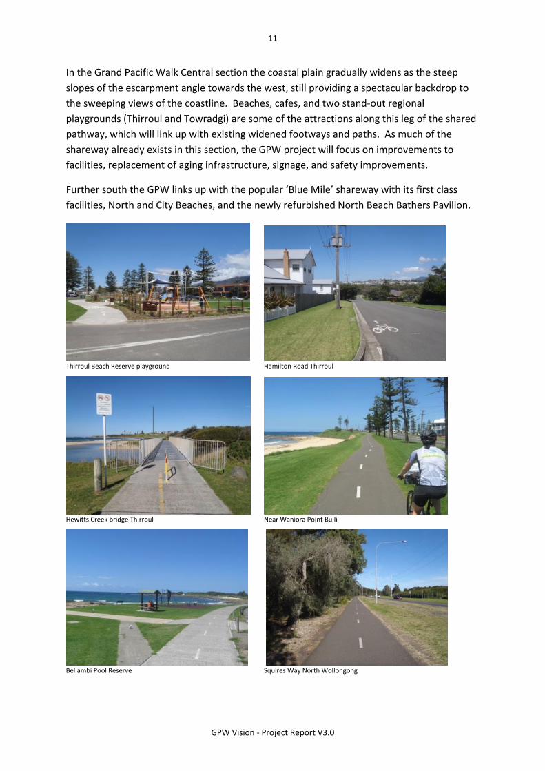
In the Grand Pacific Walk Central section the coastal plain gradually widens as the steep
slopes of the escarpment angle towards the west, still providing a spectacular backdrop to
the sweeping views of the coastline. Beaches, cafes, and two stand‐out regional
playgrounds (Thirroul and Towradgi) are some of the attractions along this leg of the shared
pathway, which will link up with existing widened footways and paths. As much of the
shareway already exists in this section, the GPW project will focus on improvements to
facilities, replacement of aging infrastructure, signage, and safety improvements.
Further south the GPW links up with the popular ‘Blue Mile’ shareway with its first class
facilities, North and City Beaches, and the newly refurbished North Beach Bathers Pavilion.
Thirroul Beach Reserve playground Hamilton Road Thirroul
Hewitts Creek bridge Thirroul Near Waniora Point Bulli
Bellambi Pool Reserve Squires Way North Wollongong

12
GPW Vision ‐ Project Report V3.0
THE GRAND PACIFIC WALK ROUTE
Southern Section – Wollongong to Lake Illawarra

13
GPW Vision ‐ Project Report V3.0
The Grand Pacific Walk Southern section is one of contrasts. The route leaves the CBD and
the Blue Mile behind, passes the WIN Entertainment Centre and Stadium, and leads to the
remarkable industrial landscape of Port Kembla. The port itself provides a sweeping view to
the north, before following the existing shareway south past the rocky shoreline of MM
Beach, Hill 60, and the spectacular crescent of sand at Port Kembla beach.
The route then leads out of the commercial zone of Warrawong, and with glimpses of Lake
Illawarra and the mountains to the west, down to the beaches, bridge, and the lake proper
at Windang.
North Beach Brighton Lawn
Spring Hill Road Spring Hill (near Port Kembla) Five Islands Road Port Kembla
Port Kembla Beach Windang near Windang Tourist Park

14
GPW Vision ‐ Project Report V3.0

15
GPW Vision ‐ Project Report V3.0
ROUTE INVESTIGATION PHASE

16
GPW Vision ‐ Project Report V3.0
ROUTE INVESTIGATION PHASE
SITE ANALYSIS
Extract from Sheet 5 of the GPW Site Analysis
The Grand Pacific Walk route was investigated on the ground with site visits by car, walking,
and cycling the entire route. This was combined with desktop data collection, and
community and stakeholder input. The results have been collated into an 18 sheet analysis
plan set and formed the basis of all design proposals in the draft Masterplan.
Existing conditions, issues, and features noted on the analysis set included:
Adequacy of existing walk and shareways
Gaps in the network
Viewing areas and focal points
Toilets and carparks
End of trip facilities
Playgrounds
Food outlets.
The Site Analysis documentation is detailed on 18 plans showing the entire route from the
Royal National Park to Lake Illawarra. These plans are compiled in Attachment A of the
Grand Pacific Walk Draft Masterplan documentation.

17
GPW Vision ‐ Project Report V3.0
ROUTE INVESTIGATION PHASE
ENGAGEMENT REPORT
Development of the Grand Pacific Walk Masterplan and Stage One Engagement Strategy
commenced in January 2013 with a focus group and workshop to engage with key external
stakeholders. The formal exhibition period for the draft GPW Masterplan and Stage One
was from 18 February to 18 March 2013. Six community kiosks were held to discuss the
proposals and collect community feedback. A community feedback form was also developed
for community members to make suggestions to be included in the planning process and to
highlight any issues or concerns.
During the exhibition period, over 250 community members were engaged and 88
submissions were received. Of those submissions, 47 respondents used Council’s feedback
form or were in the form of open submissions (letters or emails) and 41 submissions were
received as on‐line feedback forms. In total four group submissions were received. The
general consensus, from conversation with the community and from written feedback, was
that the community fully supported the share path proposed in Stage One.
A number of recurring themes were identified during the engagement process, such as:
Signage needed to emphasise local history, directions, landmarks, flora and fauna
Easy access to amenities, bubblers, seating, shade and parking
Separation of pedestrians and cyclists where possible to allow both to enjoy the path
Safety with respect to guard rails, lighting, and separation from vehicles
Consider property owners regarding driveways, access, and parking
Promote local businesses and encourage local economic development
Attract tourists and visitors
Provide safe access to villages and schools by foot and on bicycles
Concern that the project will not be completed and / or will be poorly maintained
High expectations for a short time frame.
The Engagement Strategy is planned to continue with the exhibition of the draft Masterplan
and Stage One implementation plans in the form of update meetings, media releases,
community events, and dissemination of information on the Grand Pacific Walk web page
on council’s website.
Refer to Attachment B – GPW Background Reports for the full report.

18
GPW Vision ‐ Project Report V3.0
ROUTE INVESTIGATION PHASE
PEDESTRIAN AND CYCLE SURVEY AND ANALYSIS
Council commissioned AECOM Australia
Pty Ltd to carry out pedestrian and
bicycle count surveys at 30 key locations
on the existing and future shared
pathway network between the Royal
National Park and Lake Illawarra. A
demand analysis assessment was also
requested for the Stage One section of
the route.
As there was no existing rigorous survey data on Council’s records for our shared pathway
network, it was considered vital for future GPW planning that both a snapshot of usage be
gathered, and an analysis of potential demand for the northern area, including Stage One,
assuming the gaps in the network were filled. The data collected was also used in the
preparation of the latest Wollongong Bike Plan.
Existing Demand
Surveys were carried out over two days on Saturday 18 May (10am to 2pm) and Wednesday
22 May 2013 (6am to 9am and 3pm to 6pm).
Pedestrians were the highest absolute number of users (9,025) with three sites recording
well over 1,000 persons – City Beach viewing area, Nicholson Park Woonona, and North
Wollongong Surfclub carpark. 6,495 cyclists were recorded in the corridor with the top two
sites being Nicholson Park Woonona and Squires Way adjacent to Stuart Park.
Demand Analysis Stage One Section
Relevant Australian and international literature was reviewed to complement the demand
analysis. The report predicts an over 50% increase in use over 20 years north of Sea Cliff
Bridge, and over 90% increase between Austinmer and Sea Cliff Bridge if the shareway links
were constructed.
Refer to Attachment B – GPW Background Reports for the full report.
19
GPW Vision ‐ Project Report V3.0
ROUTE INVESTIGATION PHASE
STAGE ONE SAFETY AUDIT
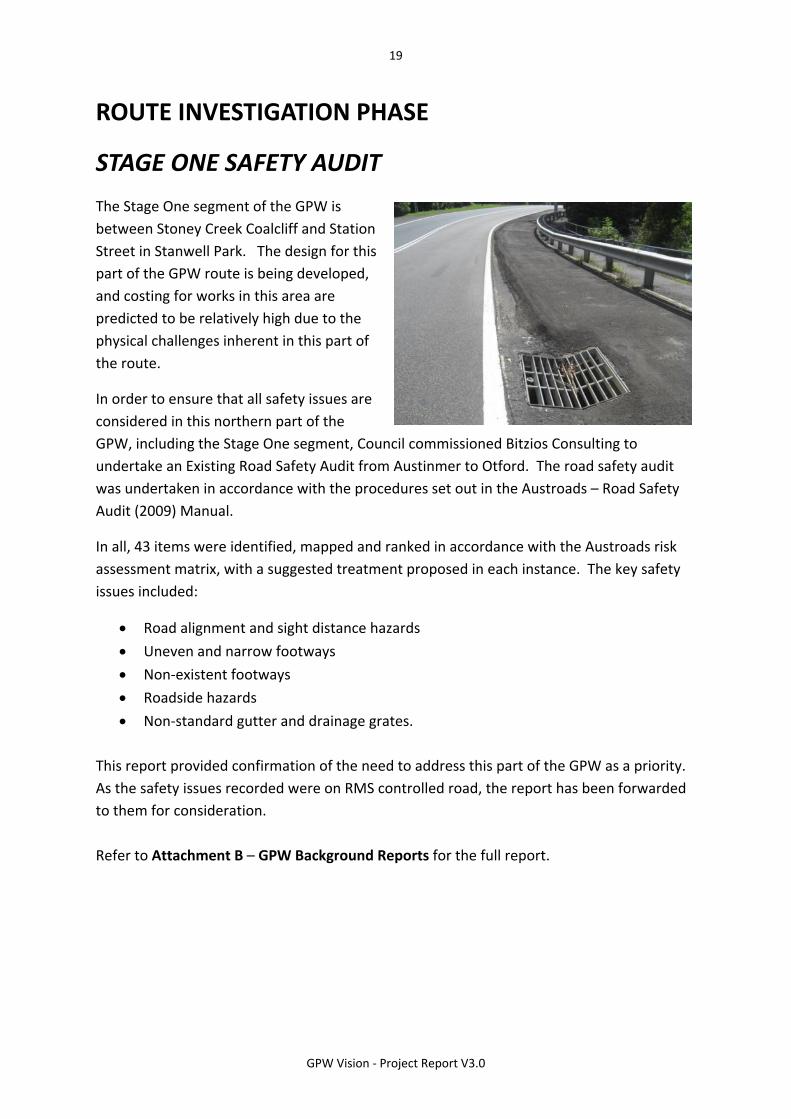
The Stage One segment of the GPW is
between Stoney Creek Coalcliff and Station
Street in Stanwell Park. The design for this
part of the GPW route is being developed,
and costing for works in this area are
predicted to be relatively high due to the
physical challenges inherent in this part of
the route.
In order to ensure that all safety issues are
considered in this northern part of the
GPW, including the Stage One segment, Council commissioned Bitzios Consulting to
undertake an Existing Road Safety Audit from Austinmer to Otford. The road safety audit
was undertaken in accordance with the procedures set out in the Austroads – Road Safety
Audit (2009) Manual.
In all, 43 items were identified, mapped and ranked in accordance with the Austroads risk
assessment matrix, with a suggested treatment proposed in each instance. The key safety
issues included:
Road alignment and sight distance hazards
Uneven and narrow footways
Non‐existent footways
Roadside hazards
Non‐standard gutter and drainage grates.
This report provided confirmation of the need to address this part of the GPW as a priority.
As the safety issues recorded were on RMS controlled road, the report has been forwarded
to them for consideration.
Refer to Attachment B – GPW Background Reports for the full report.

20
GPW Vision ‐ Project Report V3.0
ROUTE INVESTIGATION PHASE
ECONOMIC IMPACT ASSESSMENT
In order to assess the potential economic impact of the construction of the Grand Pacific
Walk and its associated facilities, Council commissioned the University of Wollongong’s
Centre for Small Business and Regional Research to model the likely economic benefits in an
Economic Impact Assessment.
Benefits were calculated for the initial construction phase, and the ongoing operational (or
usage) phase. The construction phase was assumed to be a cumulative period of two years
(although likely to be much longer with interruptions). The forecast of ongoing economic
impacts is based on an assumption that the GPW would provide an opportunity to convert
‘passive drive‐by tourism’ associated with the Grand Pacific Drive into tangible tourist
expenditure in the local economy that would have both direct and flow‐on effects.
The results of the report’s analysis estimate that the GPW would produce a combined
benefit to the local economy of up to $45.3M over the construction phase. Including direct,
indirect, and induced effects, the report forecasts approximately 113 Full Time Equivalent
(FTE) jobs sustained during construction, and between 16 and 162 jobs sustained during a
typical year of operation.
The considered range of tourism expenditure scenarios suggested annual increases of
between $2.8M and $28.3M in gross output across the economy. There were also
significant indirect economic development benefits that would accrue to the region from
the development of a world class piece of recreation and tourism infrastructure, potentially
further enhancing the image of Wollongong as a place to visit and live.
The report signals a clear potential for the GPW to have significant one‐off and on‐going
economic benefits. These benefits are dependant however, on several factors, including the
final amount of funding, timing, and level of infrastructure provided, and the ability of the
GPW to attract visitors from outside the local area.
The report recommends that a detailed Tourism Opportunity Study be included in Council’s
masterplanning activities to best leverage the significant potential for tourism growth the
GPW would provide.
Refer to Attachment B – GPW Background Reports for the full report.
21
GPW Vision ‐ Project Report V3.0
DRAFT MASTERPLAN
22
GPW Vision ‐ Project Report V3.0
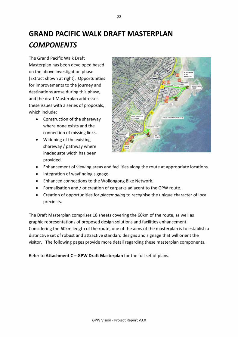
GRAND PACIFIC WALK DRAFT MASTERPLAN
COMPONENTS
The Grand Pacific Walk Draft
Masterplan has been developed based
on the above investigation phase
(Extract shown at right). Opportunities
for improvements to the journey and
destinations arose during this phase,
and the draft Masterplan addresses
these issues with a series of proposals,
which include:
Construction of the shareway
where none exists and the
connection of missing links.
Widening of the existing
shareway / pathway where
inadequate width has been
provided.
Enhancement of viewing areas and facilities along the route at appropriate locations.
Integration of wayfinding signage.
Enhanced connections to the Wollongong Bike Network.
Formalisation and / or creation of carparks adjacent to the GPW route.
Creation of opportunities for placemaking to recognise the unique character of local
precincts.
The Draft Masterplan comprises 18 sheets covering the 60km of the route, as well as
graphic representations of proposed design solutions and facilities enhancement.
Considering the 60km length of the route, one of the aims of the masterplan is to establish a
distinctive set of robust and attractive standard designs and signage that will orient the
visitor. The following pages provide more detail regarding these masterplan components.
Refer to Attachment C – GPW Draft Masterplan for the full set of plans.

23
GPW Vision ‐ Project Report V3.0
GRAND PACIFIC WALK DRAFT MASTERPLAN
TYPICAL SHAREPATH ARRANGEMENTS
The 60kms of the Grand Pacific Walk incorporates a substantial amount of existing shareway
network, however, in providing the ‘missing links’, a number of design solutions will be
necessary. The page below from the draft masterplan outlines 6 different indicative design
solutions that will be considered for the shareway depending on the specific nature of the
location.

24
GPW Vision ‐ Project Report V3.0
GRAND PACIFIC WALK DRAFT MASTERPLAN
PICNIC CLUSTERS
The Grand Pacific Walk route traverses some of
the most spectacular coastal scenery in the
country. Linking up the villages and towns of this
coastal strip is an important objective of the
project, however, our analysis also revealed the
need for enhancement of available facilities to
encourage GPW users to stop along the way and
enjoy the view, or just have a rest.
The draft masterplan includes a proposal for a
standard arrangement of facilities – the Picnic
Cluster (typical plan shown at right, and
perspective view below). This arrangement includes furniture, a garbage bin, bike rack, tree
planting, signage, distinctive paving, and an opportunity for the integration of suitable
artwork in the paving or tree‐guard. These clusters can be enlarged or made smaller
depending on location and usage, and can also provide drinking water where a water
service is available.

25
GPW Vision ‐ Project Report V3.0
GRAND PACIFIC WALK DRAFT MASTERPLAN
PLACEMAKING
The GPW project links a series of coastal locations,
each with their own history and character. From the
steep cliffs, forests and beaches of the north, to the
industrial landscape of the steelworks, and the broad
sweep of Lake Illawarra. The draft Masterplan
proposes to create opportunities for the integration
of both signage and artwork at each of the picnic
cluster and viewing area locations where
appropriate.
Local history and stories could be presented
in various forms, drawing viewers’ attention
to the special nature of the particular place.
There are many examples of placemaking of
this sort in our local area, such as artwork,
words, and historical images that have been
integrated into paving, furniture, and as
stand‐alone pieces. This placemaking will
become a long term part of the project,
progressed as funding or grants become
available.
The examples shown here are from Flagstaff
Hill and Osborne Park Wollongong, and
Mike Dwyer Reserve, Coledale.

26
GPW Vision ‐ Project Report V3.0
GRAND PACIFIC WALK DRAFT MASTERPLAN
FURNITURE AND MATERIALS
The draft Masterplan incorporates a range of furniture and materials that will make
facilities at the resting points along the route consistent in appearance. The proposed range
will ensure that furniture and materials used along the route are robust, attractive, and
suitable for the coastal environment.

27
GPW Vision ‐ Project Report V3.0
GRAND PACIFIC WALK DRAFT MASTERPLAN
SIGNAGE STRATEGY
An important part of the project is not only to provide safe passage for pedestrians and
cyclists, but also to provide them with necessary way‐finding signage along the route. The
GPW Signage Strategy is intended to provide this information in a consistent format and
appearance.
Directional maps, distance markers, and site specific information will be incorporated into a
‘family’ of different types of signs depending on the requirements of each site. Consistent
colours, font sizes, and construction materials will help to guide people along the walk. It is
expected that the Tall Trail Markers will be the most common type of sign, used at regular
intervals, largely to define the route and provide distances travelled.
Below are two extracts from the GPW signage strategy. The full document can be reviewed
in Attachment B – GPW Background Reports.

28
GPW Vision ‐ Project Report V3.0
GRAND PACIFIC WALK DRAFT MASTERPLAN
MARKETING MATERIAL
The Grand Pacific Walk will be a long term project that will provide benefit to the
community for many years. In order to facilitate updates and communication about the
project, and to provide high quality documents to address funding opportunities, a set of
promotional material, maps, and logos has been produced.
Below are several examples of this material, the project web page, logo, and two extracts
from the project brochure.

29
GPW Vision ‐ Project Report V3.0
30
GPW Vision ‐ Project Report V3.0
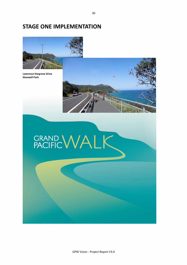
STAGE ONE IMPLEMENTATION
Lawrence Hargrave Drive Stanwell Park

31
GPW Vision ‐ Project Report V3.0
GRAND PACIFIC WALK STAGE ONE
Since the project’s inception, the highest priority for Council has been to focus on the part
of the route from the Sea Cliff Bridge to Station Street in Stanwell Park. North of Paterson
Road, the route has significant topographical challenges, narrow roads, and virtually no safe
space for pedestrians and cyclists.
Council’s approach has been to firstly develop a costed concept plan for the whole route,
then develop more detailed designs for the Stoney Creek Bridge location and at Coalcliff
Station. Extracts of these plans are detailed below, and the entire set of plans can be found
in Attachment D – the GPW Vision Stage One Implementation set.

32
GPW Vision ‐ Project Report V3.0
STAGE ONE COSTED CONCEPT PLAN
A detailed costed concept plan has been
completed from Stoney Creek Bridge Coalcliff to
Station Street in Stanwell Park showing a new
shareway alignment on the eastern side of
Lawrence Hargrave Drive. This includes sections
of on‐ground shareway, elevated portions, on‐
street linemarking, and a new connection from
the southern end of Lower Coast Road to
Lawrence Hargrave Drive.
The two photographs on this page show typical
sections of road along this segment, with
virtually no space for pedestrians or cyclists.
The plan below is an extract from the Stage One
costed concept plan, just south of Lower Coast
Road.
SECTION SOUTH OF LOWER COAST ROAD

33
GPW Vision ‐ Project Report V3.0
STONEY CREEK COALCLIFF, SHAREWAY BRIDGE
Through the development of the Masterplan and the related consultation, the need for a
shareway bridge next to the existing road bridge at this location was identified. Tender
documentation has been completed and the construction of the bridge is programmed to
commence in the first half of 2014.
The two images below show the existing bridge on Lawrence Hargrave Drive, and what the
proposed shareway bridge addition may look like.

34
GPW Vision ‐ Project Report V3.0
COALCLIFF STATION PRECINCT UPGRADE
Providing safe access for pedestrians and cyclists
in the area of Coalcliff Station is particularly
challenging due to the constraints of the
topography and width of the road reserve. The
need for safer pedestrian crossing facilities, a
new bus bay, and adequate width for the GPW
shareway alignment on the east side of Lawrence
Hargrave Drive became clear during the
consultation phase. A concept solution has been
developed and is in the final stages of design
development. NSW Roads & Maritime Services
(RMS) has been an enthusiastic funding partner in
this proposal and the project is programmed to
proceed in the current financial year with their
assistance.
The adjacent stages of the route northward to
Stanwell Park are planned for design and
construction as sufficient budgets are available.

35
GPW Vision ‐ Project Report V3.0
GRAND PACIFIC WALK – LOOKING AHEAD
The Grand Pacific Walk is a long‐term project that Council, with the community, will be
working towards in stages over the coming years.
To stay up to date on the progress of the GPW, visit our website at
www.wollongong.nsw.gov.au/grandpacificwalk or call us on (02) 4227 7111.

36
GPW Vision ‐ Project Report V3.0