gps working and interfacingcourses.daiict.ac.in/pluginfile.php/5863/mod_resource/content/0/... ·...
TRANSCRIPT

GPS: GPS: Working Principle and Working Principle and
InterfacingInterfacingTeam D1 Team D1
Ranajeet Anand(200601186)Ranajeet Anand(200601186)Shashi Kumar(200601155)Shashi Kumar(200601155)

Presentation FlowPresentation Flow
Existing TechnologiesExisting Technologies LimitationsLimitations What is GPS What is GPS ConceptConcept WorkingWorking ConstraintsConstraints GPS Receiver Output ProtocolsGPS Receiver Output Protocols Interfacing of GPS with uCInterfacing of GPS with uC Use in Embedded SystemsUse in Embedded Systems ReferencesReferences

Existing TechnologiesExisting TechnologiesLand-based electronic navigation systemsLand-based electronic navigation systems In the 1930's radio beacons were used to provide In the 1930's radio beacons were used to provide
bearings from airfieldsbearings from airfields Radio navigation systems like - LORAN, (Long Range Radio navigation systems like - LORAN, (Long Range
Aid to Navigation). Positions were determined by the Aid to Navigation). Positions were determined by the timing of signalstiming of signals
In 1960s the Omega system provided worldwide In 1960s the Omega system provided worldwide electronic navigation coverage for the first timeelectronic navigation coverage for the first time
In mid-1960's: US Navy's NAVigation SATellite System In mid-1960's: US Navy's NAVigation SATellite System (NAVSAT), also known as TRANSIT, was developed to (NAVSAT), also known as TRANSIT, was developed to provide more accurate positions for ships and provide more accurate positions for ships and submarines.submarines.

LimitationsLimitations Unavailability for the general publicUnavailability for the general public Land based systems, so not much accurateLand based systems, so not much accurate Low frequency of updating locationLow frequency of updating location Lack of 24-hour availabilityLack of 24-hour availability

What is GPSWhat is GPS
Definition:Definition: GPS stands for Global Positioning SystemGPS stands for Global Positioning System A “ GPS System” usually means a GPS ReceiverA “ GPS System” usually means a GPS Receiver
What is GPSWhat is GPS
The GPS is a constellation of 27 Earth-orbiting The GPS is a constellation of 27 Earth-orbiting satellites (24 in operation and three extras in satellites (24 in operation and three extras in case one fails). case one fails).
The U.S. military developed and implemented The U.S. military developed and implemented this satellite network as a military navigation this satellite network as a military navigation system, but soon opened it up to everybody system, but soon opened it up to everybody else.else.
ConceptConceptGPS Components:GPS Components:
There are three Components : There are three Components : 1) ground stations that controlled the system, 1) ground stations that controlled the system, 2) a "constellation" of satellites in Earth orbit, and 2) a "constellation" of satellites in Earth orbit, and 3) receivers carried by users. 3) receivers carried by users.

ConceptConceptSolar-powered satellites orbit the earth at 19,300 km Solar-powered satellites orbit the earth at 19,300 km
making two complete rotations every daymaking two complete rotations every day
Arrangement of orbits such that at least four satellites Arrangement of orbits such that at least four satellites
"visible" in the sky"visible" in the sky..
Job of ReceiverJob of Receiver Locate 4 or more satellitesLocate 4 or more satellites figure out the distance to each,figure out the distance to each, Deduce its own location by the Trilateration PrincipleDeduce its own location by the Trilateration Principle

ConceptConcept Principle of TrilaterationPrinciple of Trilateration
2-D Trilateration2-D Trilateration
2 circles intersect at 2 2 circles intersect at 2 pointspoints
Intersection with 3Intersection with 3rdrd circle circle => Accurate Location=> Accurate Location

ConceptConcept Principle of TrilaterationPrinciple of Trilateration
3-D Trilateration3-D TrilaterationFour spheres are neededFour spheres are needed 2 spheres intersect in a 2 spheres intersect in a
circlecircle A 3A 3rdrd sphere intersects at sphere intersects at
2 points of the circle2 points of the circle Intersection with 4Intersection with 4thth
sphere => Accurate sphere => Accurate PositionPosition

ConceptConcept 3 – D Trilateration3 – D Trilateration
The 3 spheres are formed by 3 satellitesThe 3 spheres are formed by 3 satellites The earth itself acts as the 4The earth itself acts as the 4thth sphere sphere To improve accuracy and provide precise altitude To improve accuracy and provide precise altitude
information, receivers generally look to four or more information, receivers generally look to four or more satellitessatellites

WorkingWorking The satellites transmit high-frequency, low-power radio The satellites transmit high-frequency, low-power radio
signals signals
These signals are received by the GPS receiverThese signals are received by the GPS receiver Better units with multiple receivers can pick Better units with multiple receivers can pick
up signals from several satellites up signals from several satellites
Radio waves travel at speed of light so receiver can Radio waves travel at speed of light so receiver can calculate time taken by signal to arrivecalculate time taken by signal to arrive
This is the distance of satellite from receiverThis is the distance of satellite from receiver

WorkingWorking The Clock IssueThe Clock Issue
To calculate distance, satellite and receiver clocks To calculate distance, satellite and receiver clocks should be accurately synchronizedshould be accurately synchronized
The satellites contain atomic clocks which are extremely The satellites contain atomic clocks which are extremely accurate, and accurate with respect to each otheraccurate, and accurate with respect to each other
So, the receiver also would need to have a highly So, the receiver also would need to have a highly accurate atomic clockaccurate atomic clock
This is not possible since atomic costs are very This is not possible since atomic costs are very expensiveexpensive

WorkingWorking The Clock Issue: SolutionThe Clock Issue: Solution
The receiver itself uses an ordinary quartz clock, which it The receiver itself uses an ordinary quartz clock, which it constantly resetsconstantly resets
Incoming signals from four or more satellites used to Incoming signals from four or more satellites used to gauge its own inaccuracygauge its own inaccuracy
The receiver sets its clock at a time value such that all The receiver sets its clock at a time value such that all signals that it is receiving align at a single point in spacesignals that it is receiving align at a single point in space

WorkingWorking The Clock Issue: SolutionThe Clock Issue: Solution
Since a 4Since a 4thth satellite is used, all 4 spheres will not satellite is used, all 4 spheres will not intersect at 1 point. intersect at 1 point.
The receiver makes necessary adjustments so that all 4 The receiver makes necessary adjustments so that all 4 spheres intersect at 1 pointspheres intersect at 1 point
Based on this, it resets its clock to be in sync with the Based on this, it resets its clock to be in sync with the satellite's atomic clock, thus ensuring that its clock is as satellite's atomic clock, thus ensuring that its clock is as accurate as the atomic clocksaccurate as the atomic clocks
ConstraintsConstraints
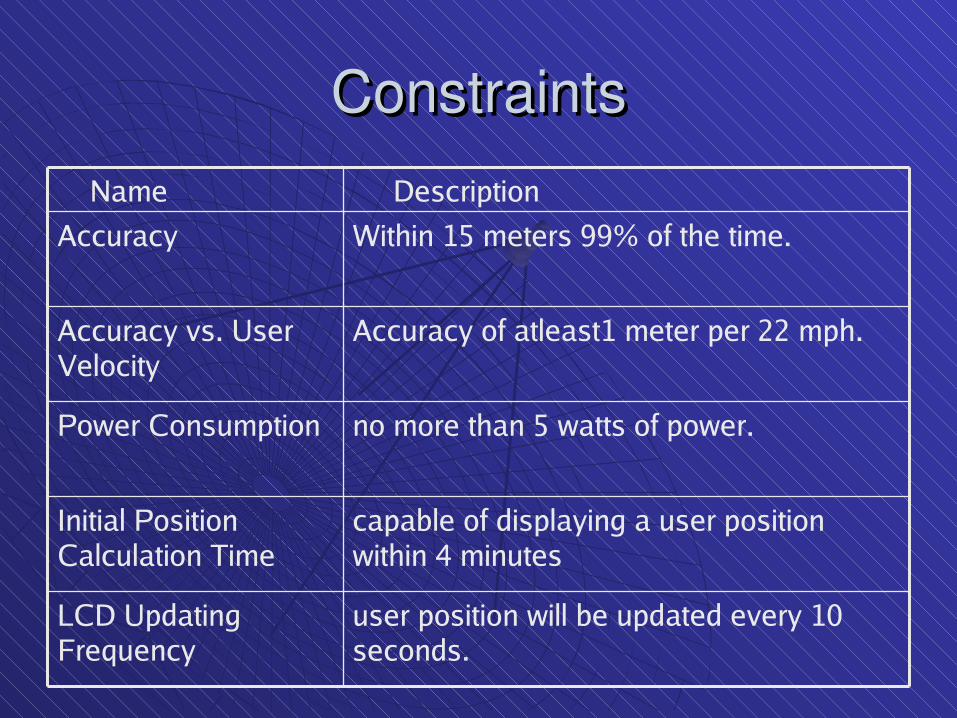
capable of displaying a user position within 4 minutes
Initial Position Calculation Time
user position will be updated every 10 seconds.
LCD Updating Frequency
no more than 5 watts of power.Power Consumption
Accuracy of atleast1 meter per 22 mph. Accuracy vs. User Velocity
Within 15 meters 99% of the time. Accuracy
Description Name

ConstraintsConstraints Scope for ErrorsScope for Errors:: Satellite errorsSatellite errors
Errors in modeling clock offsetErrors in modeling clock offsetLatency in trackingLatency in tracking
Atmospheric propagation errors Atmospheric propagation errors Through the ionosphere, carrier experiences phase Through the ionosphere, carrier experiences phase
advance advance
Dependent onDependent on Geomagnetic latitudeGeomagnetic latitude Time of the dayTime of the day Elevation of the satelliteElevation of the satellite

ConstraintsConstraints Errors due toErrors due to MultipathMultipath
Receiver NoiseReceiver Noise
Forces on the GPS satelliteForces on the GPS satellite Earth is not a perfect sphere and hence Earth is not a perfect sphere and hence uneven uneven
gravitational potential distributiongravitational potential distributionOther heavenly bodies attract the satellite, Other heavenly bodies attract the satellite, but but
these are very well modeledthese are very well modeled
Errors due to GeometryErrors due to Geometry

Output Protocols from a GPS Output Protocols from a GPS ReceiverReceiver
TSIP (Trimble Standard Interface ProtocolTSIP (Trimble Standard Interface Protocol ) ) TSIP is a powerful binary packet protocol that allows the system TSIP is a powerful binary packet protocol that allows the system
designer maximum configuration control over the GPS receiver for designer maximum configuration control over the GPS receiver for optimum performance in any number of applications. optimum performance in any number of applications.
TAIP (Trimble ASCII Interface ProtocolTAIP (Trimble ASCII Interface Protocol )) TAIP is the Trimble ASCII interface protocol designed specifically for TAIP is the Trimble ASCII interface protocol designed specifically for
vehicle tracking applications. It is a bi-directional vehicle tracking applications. It is a bi-directional protocolprotocol using using simple ASCII commands with the associated ASCII responses. simple ASCII commands with the associated ASCII responses.

Output Protocols from a GPS Output Protocols from a GPS ReceiverReceiver
NMEA (National Marine Electronic Association)NMEA (National Marine Electronic Association) NMEA 0183 is an industry standard protocol common to marine NMEA 0183 is an industry standard protocol common to marine
applications. NMEA provides direct compatibility with other NMEA applications. NMEA provides direct compatibility with other NMEA capable devices such as chart plotters, radars, etc. NMEA capable devices such as chart plotters, radars, etc. NMEA messages and output rates can be user selected as required.messages and output rates can be user selected as required.
DGPS (DGPS (differential GPSdifferential GPS )) A technique used to improve positioning or navigation accuracy by A technique used to improve positioning or navigation accuracy by
determining the positioning error at a known location and determining the positioning error at a known location and subsequently incorporating a corrective factor (by real-time subsequently incorporating a corrective factor (by real-time transmission of corrections or by post processing) into the position transmission of corrections or by post processing) into the position calculations of another receiver operating in the same area and calculations of another receiver operating in the same area and simultaneously tracking the same satellites. simultaneously tracking the same satellites.
Above all protocols the NMEA protocol is the standard protocol Above all protocols the NMEA protocol is the standard protocol for all GPS. for all GPS.

Conexant Jupiter TU30D410 GPSReceiver Pin connection

Interfacing of GPSInterfacing of GPS The receiver can output GPS data in 2 message
protocols –
Rockwell binary message format
NMEA ASCII message format

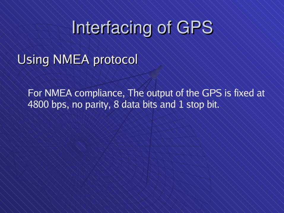
Interfacing of GPSInterfacing of GPSUsing NMEA protocolUsing NMEA protocol
For NMEA compliance, The output of the GPS is fixed at 4800 bps, no parity, 8 data bits and 1 stop bit.

NMEA SENTENCE TYPESNMEA SENTENCE TYPES
The NMEA standard provides quite a range of sentences. Each The NMEA standard provides quite a range of sentences. Each sentence starts with a $ and ends with a * and an optional 8-bit sentence starts with a $ and ends with a * and an optional 8-bit checksum expressed as two hexadecimal characters.checksum expressed as two hexadecimal characters.
Sentence DescriptionSentence Description $GPRMC Recommended minimum specific GNSS data$GPRMC Recommended minimum specific GNSS data $GPGGA Global positioning system fixed data$GPGGA Global positioning system fixed data $GPGLL Geographic position - latitude / longitude$GPGLL Geographic position - latitude / longitude $GPGSA GNSS DOP and active satellites$GPGSA GNSS DOP and active satellites $GPGSV GNSS satellites in view$GPGSV GNSS satellites in view $GPVTG Course over ground and ground speed$GPVTG Course over ground and ground speed

$GPRMC$GPRMC$GPRMC,225446,A,4916.45,N,12311.12,W,000.5,054.7, $GPRMC,225446,A,4916.45,N,12311.12,W,000.5,054.7, 191107,020.3,E*68191107,020.3,E*68
225446 Time of fix 22:54:46 UTC 225446 Time of fix 22:54:46 UTC A Navigation receiver warning A = Valid A Navigation receiver warning A = Valid position, V = Warning position, V = Warning 4916.45,N Latitude 49 deg. 16.45 min. North 4916.45,N Latitude 49 deg. 16.45 min. North 12311.12,W Longitude 123 deg. 11.12 min. West 12311.12,W Longitude 123 deg. 11.12 min. West 000.5 Speed over ground, Knots000.5 Speed over ground, Knots 054.7 Course Made Good, degrees true 054.7 Course Made Good, degrees true 191107 UTC Date of fix, 19 November 2007 191107 UTC Date of fix, 19 November 2007 020.3,E Magnetic variation, 20.3 deg. East 020.3,E Magnetic variation, 20.3 deg. East *68 mandatory checksum*68 mandatory checksum
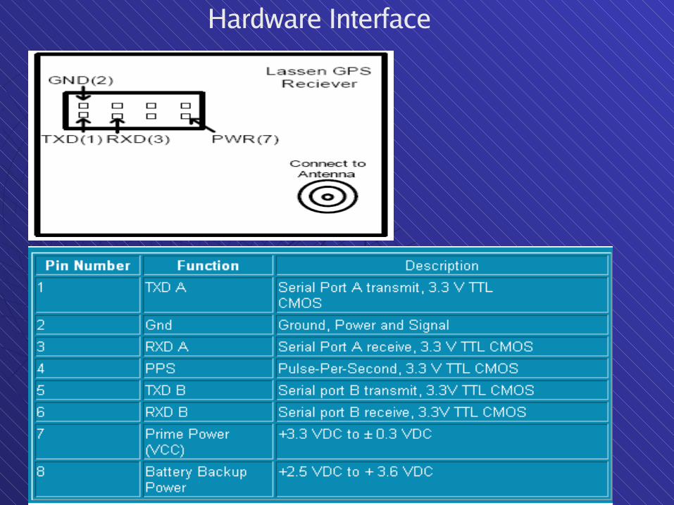
Hardware Interface

Connections with the GPSConnections with the GPS
The signals available at the serial pins of the GPS are The signals available at the serial pins of the GPS are TTL level.TTL level.
To read the GPS output on Hyper terminal, the TTL To read the GPS output on Hyper terminal, the TTL signal is converted into RS 232 using a Max 232 ICsignal is converted into RS 232 using a Max 232 IC
The input messages are sent to the GPS using a simple The input messages are sent to the GPS using a simple C codeC code

Serial Port Interface for GPS Serial Port Interface for GPS ReceiverReceiver

Some GPS Application in Some GPS Application in Embedded SystemsEmbedded Systems
GPS systems that provide the driver with the current GPS systems that provide the driver with the current
position and a local map.position and a local map. GPS devices that give the users a detailed map of the GPS devices that give the users a detailed map of the
terrain, rivers, hills and so forth, tracks and trails.terrain, rivers, hills and so forth, tracks and trails. GPS devices that enable marine users to get specific GPS devices that enable marine users to get specific
information relating to the sea bed, navigable channels, information relating to the sea bed, navigable channels, and other pieces of maritime data that enables them to and other pieces of maritime data that enables them to
navigate safely.navigate safely. GPS devices that offer an inexpensive and reliable GPS devices that offer an inexpensive and reliable
supplement to existing navigation techniques for aircraftsupplement to existing navigation techniques for aircraft

ReferencesReferences http://www.palowireless.com/gps/howgpsworks.asp http://www.palowireless.com/gps/howgpsworks.asp http://electronics.howstuffworks.com/gadgets/travel/gps.htmhttp://electronics.howstuffworks.com/gadgets/travel/gps.htm http://www.nasm.si.edu/gps/work.htmlhttp://www.nasm.si.edu/gps/work.html http://www.8051projects.info/exp12.asphttp://www.8051projects.info/exp12.asp http://home.mira.net/~gnb/gps/nmea.html#interphttp://home.mira.net/~gnb/gps/nmea.html#interp http://www.psychologie.uni-regensburg.de/Zimmer/trafficresearch/NMEA0183/index.htmlhttp://www.psychologie.uni-regensburg.de/Zimmer/trafficresearch/NMEA0183/index.html http://www.aero.org/education/primers/gps/uses.htmlhttp://www.aero.org/education/primers/gps/uses.html

THANK YOU!THANK YOU!