gps approaches - publicapps.caa.co.uk
TRANSCRIPT
GA Update June 2021
GPS APPROACHES
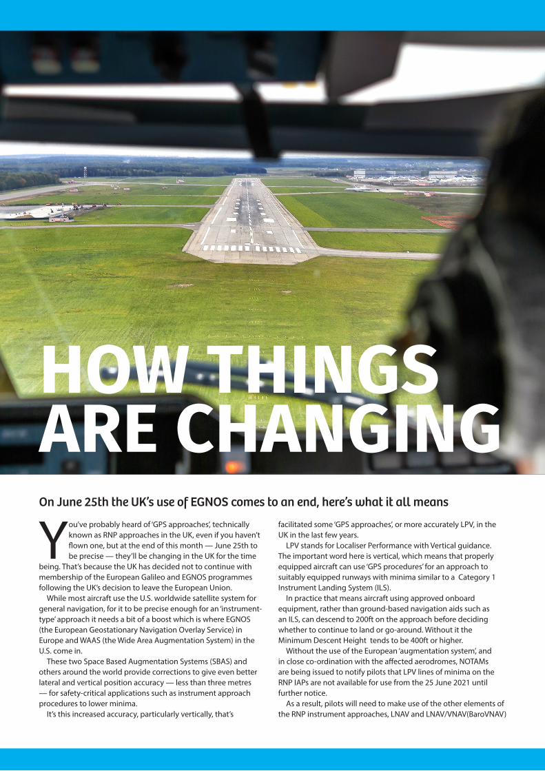
On June 25th the UK’s use of EGNOS comes to an end, here’s what it all means
You’ve probably heard of ‘GPS approaches’, technically known as RNP approaches in the UK, even if you haven’t flown one, but at the end of this month — June 25th to be precise — they’ll be changing in the UK for the time
being. That’s because the UK has decided not to continue with membership of the European Galileo and EGNOS programmes following the UK’s decision to leave the European Union.
While most aircraft use the U.S. worldwide satellite system for general navigation, for it to be precise enough for an ‘instrument-type’ approach it needs a bit of a boost which is where EGNOS (the European Geostationary Navigation Overlay Service) in Europe and WAAS (the Wide Area Augmentation System) in the U.S. come in.
These two Space Based Augmentation Systems (SBAS) and others around the world provide corrections to give even better lateral and vertical position accuracy — less than three metres — for safety-critical applications such as instrument approach procedures to lower minima.
It’s this increased accuracy, particularly vertically, that’s
facilitated some ‘GPS approaches’, or more accurately LPV, in the UK in the last few years.
LPV stands for Localiser Performance with Vertical guidance. The important word here is vertical, which means that properly equipped aircraft can use ‘GPS procedures’ for an approach to suitably equipped runways with minima similar to a Category 1 Instrument Landing System (ILS).
In practice that means aircraft using approved onboard equipment, rather than ground-based navigation aids such as an ILS, can descend to 200ft on the approach before deciding whether to continue to land or go-around. Without it the Minimum Descent Height tends to be 400ft or higher.
Without the use of the European ‘augmentation system’, and in close co-ordination with the affected aerodromes, NOTAMs are being issued to notify pilots that LPV lines of minima on the RNP IAPs are not available for use from the 25 June 2021 until further notice.
As a result, pilots will need to make use of the other elements of the RNP instrument approaches, LNAV and LNAV/VNAV(BaroVNAV)
HOW THINGS ARE CHANGING

or alternative instrument approach procedures where available, and plan flights taking account of the loss of LPV operating minima at affected airfields.
That said, Crown Dependency aerodromes such as Jersey, Guernsey and Alderney have separate arrangements for access to EGNOS and will retain their LPV procedures after June 25.
There are two EGNOS Ranging and Integrity Monitoring Stations (RIMS) in the UK and they will continue to operate; it’s also expected that the signal-in-space will remain unchanged after 25 June 2021. So, provided that the received signal is still indicating adequate integrity, pilots won’t be required to de-select the EGNOS signal from their GPS and the service can still be used in other flight phases.
UNTANGLING ‘RNP APPROACHES’‘RNP approach’ is really a catch-all name for a number of types of approach. To really understand them it’s first worth reviewing the difference between Precision and Non-Precision Approaches.
Traditionally, a Precision Approach, such as an Instrument Landing System (ILS), provides lateral and vertical guidance for a stabilised continuous descent, whereas
a Non-Precision Approach (NPA) is based on conventional navigation aids such as an NDB, VOR and DME and provides lateral guidance only to bring the aircraft to a point where the runway is in view for a visual landing. So, ’RNP approaches’ can provide both ‘non-precision’ (LNAV) approaches and approaches with vertical guidance (LPV and LNAV/VNAV) similar to those used on Precision Approaches.
‘RNP approaches’ come under the heading of Performance Based Navigation (PBN) which is becoming more established worldwide. It includes (standby for a load of acronyms…) approaches called RNP APCH and RNP AR APCH. In reality all of that’s much less complex than it sounds — RNP stands for Required Navigation Performance, while APCH is simply an abbreviation for Approach and AR for Authorisation Required.
Essentially, then, RNP and RNP AR procedures allow pilots to use very accurate onboard navigation kit for approaches instead of traditional ground-based external guidance aids. In some circumstances they also allow the replacement of visual and circling approaches by instrument approaches.
So put simply, RNP and RNP AR
procedures can provide a lateral and vertical GPS path for pilots to fly to a decision height of 200ft from which the decision to continue the approach can be made.
The end of the EGNOS agreement in the UK will only impact the LPV elements of an RNP APCH (Instrument Approach Procedures) IAPs approach, so only the LPV line of minima will be NOTAM’d as unavailable, before being withdrawn. LNAV (Lateral Navigation only) and LNAV/ VNAV (Lateral and Barometric VNAV) lines of minima published on RNP APCH will continue to be available.
To use ‘RNP approaches’ aircraft need to have a suitable IFR approved GNSS set-up installed. The equipment must also contain an up-to-date navigation database with details for the required ‘RNP approach procedure’ to an airfield. When activated, the aircraft navigation equipment automatically sequences through the procedure’s legs to bring the aircraft to the runway.
There must also be an On Board Performance and Alerting system to warn the pilot of positioning errors, loss of signal, degraded tracking accuracy and other parameters.
GPS APPROACHES
GPS augmentation around the world
© EUSPA
GPS APPROACHES
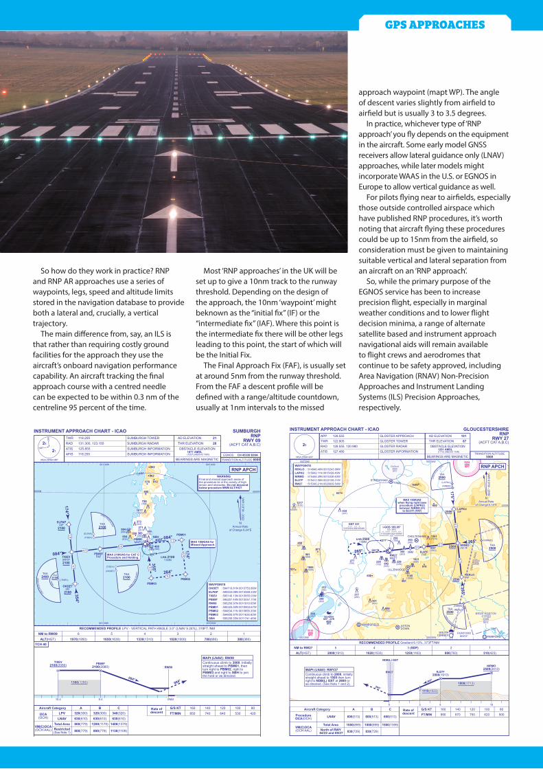
So how do they work in practice? RNP and RNP AR approaches use a series of waypoints, legs, speed and altitude limits stored in the navigation database to provide both a lateral and, crucially, a vertical trajectory.
The main difference from, say, an ILS is that rather than requiring costly ground facilities for the approach they use the aircraft’s onboard navigation performance capability. An aircraft tracking the final approach course with a centred needle can be expected to be within 0.3 nm of the centreline 95 percent of the time.
Most ‘RNP approaches’ in the UK will be set up to give a 10nm track to the runway threshold. Depending on the design of the approach, the 10nm ‘waypoint’ might beknown as the “initial fix” (IF) or the “intermediate fix” (IAF). Where this point is the intermediate fix there will be other legs leading to this point, the start of which will be the Initial Fix.
The Final Approach Fix (FAF), is usually set at around 5nm from the runway threshold. From the FAF a descent profile will be defined with a range/altitude countdown, usually at 1nm intervals to the missed
approach waypoint (mapt WP). The angle of descent varies slightly from airfield to airfield but is usually 3 to 3.5 degrees.
In practice, whichever type of ‘RNP approach’ you fly depends on the equipment in the aircraft. Some early model GNSS receivers allow lateral guidance only (LNAV) approaches, while later models might incorporate WAAS in the U.S. or EGNOS in Europe to allow vertical guidance as well.
For pilots flying near to airfields, especially those outside controlled airspace which have published RNP procedures, it’s worth noting that aircraft flying these procedures could be up to 15nm from the airfield, so consideration must be given to maintaining suitable vertical and lateral separation from an aircraft on an ‘RNP approach’.
So, while the primary purpose of the EGNOS service has been to increase precision flight, especially in marginal weather conditions and to lower flight decision minima, a range of alternate satellite based and instrument approach navigational aids will remain available to flight crews and aerodromes that continue to be safety approved, including Area Navigation (RNAV) Non-Precision Approaches and Instrument Landing Systems (ILS) Precision Approaches, respectively.
084°086°086°084°13001300(1280)(1280)1300(1280)
RW09RW09RW09PB09F
2100(2080)TISEV
2100(2080)
300300
300
300
600
600
300
300
600
262°
LHA 21001 MIN
354°
174°4.5 5.0
4.9
4.06.4
5.2
4.9
3.9
2100
ELPAPIAF
PB09FFAF
PBM01
PBM02PBM03
2100
OKDETIAF
2100
TISEVIAF/IF
RW09MAPt
SBH
082°
10NM
578
650
962
952
912
358
084°
084°
264°
174°
355°
984(964)
654(634)
373(353)
271(251)303303(283)(283)303(283)
199199(179)(179)199(179)
408(388)
10771077(1057)(1057)1077(1057)
720(700)
MAX 185KIAS forMissed Approach.
MAX 210KIAS for CAT C Procedure and Holding.
25NM
FRO
M TISEV
10NM
25NM FROM ELPAPTAA2100
TAA2400
(TISEV)
(TISEV)
(ELPAP)
TAA2100
25NM FRO
M O
KDETTAA
2100
(TISEV)
(OKDET)
6000N 6000N
001 30W 001 00W
001 30W 001 00W
NM to RW09 6 5 4 3 2 1 ALT(HGT) 1970(1950) 1650(1630) 1330(1310) 1020(1000) 700(680) 380(360)
Rate ofdescent
G/S KT 160 140 120 100 80 FT/MIN 850 740 640 530 420
RECOMMENDED PROFILE LPV - VERTICAL PATH ANGLE 3.0° (LNAV 5.24%), 318FT /NM
NOTE Reduced VM(C) minima applies to aircraft which manoeuvre outside the quadrant north of RWY 09/27 C/L and west of RWY 15/33 C/L.
AERO INFO DATE 15 FEB 21
SUMBURGHRNP
RWY 09(ACFT CAT A,B,C)
INSTRUMENT APPROACH CHART - ICAO
CHANGE (5/21): MAG VAR. MAG TRACKS. RAD REQUENCY.
6.410.4 0NM
24
21090°
180°
A B C 320(300) 320(300) 340(320) 630(610) 630(610) 630(610) 800(779) 1200(1179) 1400(1379)
800(779) 800(779) 1130(1109)
OCA(OCH)
Aircraft Category LPV LNAV Total Area Restricted (See Note 1)
VM(C)OCA(OCH AAL)
NAnnual Rate
of Change 0.24°E
VAR 0.9°W
- 2022
TWR 118.255 SUMBURGH TOWERRAD 131.300, 123.155 SUMBURGH RADARATIS 125.855 SUMBURGH INFORMATIONAFIS 118.255 SUMBURGH INFORMATION
AD ELEVATION 21THR ELEVATION 20
BEARINGS ARE MAGNETIC
OBSTACLE ELEVATION1077 (1057)
AMSL(ABOVE THR)
MSA 25NM ARP
MAPt (LNAV): RW09Continuous climb to 3000. Initially straight ahead to PBM01, thenturn right to PBM02, right toPBM03 and right to SBH to jointhe hold or as directed.
WARNINGFinal and missed approach areas of the procedure lie in the vicinity of high terrain and obstacles. Do not descend below procedure MNM ALT/HGT.
TRANSITION ALTITUDE 6000EGNOS CH 45339 E09A
WAYPOINTSOKDET : 594710.81N 0013753.86W ELPAP : 595533.08N 0013948.23WTISEV : 595140.13N 0013855.03W PB09F : 595207.44N 0013057.11WRW09 : 595250.97N 0011819.03W PBM01 : 595325.50N 0010803.67W PBM02 : 594834.11N 0010658.33WPBM03 : 594800.87N 0011636.63WSBH : 595256.55N 0011741.40W
TCH 40
RNP APCH
AD 2-EGPB-8-2
350350
650650
350
350
350350
350
350
350
350
650
650
350
350
650
650
11101110(1023)(1023)
18001800(1713)(1713)265°
NIRMO2500(2413)
BJ27F2000(1913)
RW27RW27RW27
265°
1110(1023)
1800(1713)
NDB(L) GST
091°
271°LHA LHA 250025001 MIN1 MIN
LHA 25001 MIN
FAIRFORDFAIRFORD
R1552000SFC
R2042200SFC
GST 331 gst
515331N 0021004W
ASTONDOWN
SOUTHSOUTHCERNEYCERNEY
SOUTHCERNEY FAIRFORD
NYMPSFIELDNYMPSFIELDNYMPSFIELD
ULLENWOOD
CHELTENHAM
STRENSHAM
NIRMOIAF/IF
10NM
937
971
650
393(306)
1261(1174)
978
666
1046
951
981(894)
1095(1008)
981
4000I-GOS 109.95D
(Ch 36Y) igos
515332N 0021005W111'
265°265°265°
265°265°265°
175°
355°355°355°
5.0
5.0
5.05.0
NIRMOIAF/IF
LAPKUIAF
3NM3NM3NMRW27MAPT
BJ27FFAF
2500
2500
2500
REKLOREKLOIAFIAFREKLOIAF
1021(934)
1145(1058)
806(719)
277(190)
368(281)
1217(1130)
434(347)
377(290)
901(814)
2255NNMM FFRROOMM RREEKKLLOO
(REKLO)(REKLO)(NIRMO)(NIRMO)
25NM FROM REKLO
(REKLO)(NIRMO)
TAA2500
25NM FROM NIRMO
(NIRMO)
TAA2500
25NM
FRO
M LAPKU
TAA2500
(LAPKU)(NIRMO)
558(471)
VAR 0.9°W
- 2019VAR
0.9°W - 2019
NNAnnual RateAnnual Rate
of Change 0.15°Eof Change 0.15°E
5200N
5200N
002 30W002 30W002 30W 002 00W002 00W002 00W
002 30W002 30W002 30W 002 00W002 00W002 00W
Rate ofdescent
G/S KT 160 140 120 100 80 FT/MIN 990 870 750 620 500
TRANSITION ALTITUDE3000
NOTES 1 Missed Approach Procedure not available without NDB(L) GST. 2 Missed Approach Procedure shall be converted to a conventional Missed Approach upon reaching 1500. 3 No Missed Approach turns permitted prior to MAPt.
MAPt (LNAV): RWY27Continuous climb to 2800, initially straight ahead to 1500 then turn right to NDB(L) GST at 2800 or as directed. (See Note 1 and 2).
AERO INFO DATE 08 JUN 20
GLOUCESTERSHIRERNP
RWY 27(ACFT CAT A,B,C)
INSTRUMENT APPROACH CHART - ICAO
CHANGE (11/20): RNP REFERENCES ADDED. BJ27F PROFILE HEIGHT REFERENCE. MAP TEXT.
MSA 25NM ARP
WAYPOINTSREKLO : 514946.46N 0015243.99WLAPKU : 515942.11N 0015429.46WNIRMO : 515444.29N 0015336.63WBJ27F : 515412.56N 0020138.31WRW27 : 515340.21N 0020939.54W
53 100
A B C
600(513) 600(513) 600(513)
1000(899) 1000(899) 1500(1399)
830(729) 830(729)
ProcedureOCA(OCH)
Aircraft Category
LNAV
Total Area North of RWY 04/22 and 09/27
VM(C)OCA(OCH AAL)
MAX 185KIASwhen flying right base
procedure (LAPKU)between NIRMO (IF)
to BJ27F (FAF)
NAnnual Rate
of Change 0.15°E
VAR 0.9°W
- 2019
APP 128.555 GLOSTER APPROACHTWR 122.905 GLOSTER TOWERRAD 128.555, 120.980 GLOSTER RADARATIS 127.480 GLOSTER INFORMATION
AD ELEVATION 101THR ELEVATION 87OBSTACLE ELEVATION
1261(1174)
AMSL(ABOVE THR)
BEARINGS ARE MAGNETIC
28
RECOMMENDED PROFILE Gradient 6.13%, 373FT/NM NM to RW27 5 4 3 (SDF) 2 1 ALT(HGT) 2000(1913) 1620(1533) 1250(1163) 880(793) 510(423)
AD 2-EGBJ-8-7
RNP APCH
SEVERNSEP - APR
4000SFC
FAIRFORDFAIRFORDMATZMATZ**
10971097(1010)(1010)
BRIZE NORTONBRIZE NORTONCTR DCTR D35003500SFCSFC
DeffordDefford30003000SFCSFC
239(152) 642
(555)
350(263)
256(169)
326(239)
Defford3000SFC
SEVERNSEP - APR
4000SFC
BRIZE NORTONCTR D3500SFC
OXF
ORD
AIA
A50
00SF
C
FAIRFORDMATZ*
1097(1010)
349(262)
353(266)