government of malawi ministry of healthhealth.bmz.de/what_we_do/climate_health/vulnerability... ·...
TRANSCRIPT
Government of Malawi
Ministry of Health
VULNERABILITY AND ADAPTATION ASSESSMENT OF THE HEALTH
SECTOR IN MALAWI TO IMPACTS OF CLIMATE CHANGE
December, 2015

i
CONTRIBUTING RESEARCHERS
Dr. Bagrey M Ngwira - Principal Investigator, University of Malawi – The Polytechnic;
Dr. Geoffrey M Chavula - Deputy Principal Investigator, University of Malawi –
The Polytechnic;
Mr. Kenneth J Gondwe - Co-Investigator, University of Malawi – The Polytechnic;
Dr. Lawrence Kazembe - Co-Investigator, University of Namibia; and
Dr. Themba Mzilahowa - Co-Investigator, University of Malawi – College of Medicine.
Photo credit: ICRISAT, NGONEWS.COM and JUSTGIVING.COM
ii
EXECUTIVE SUMMARY Malawi is one of the seven countries that is implementing a multi-agency Global Framework for
Climate Services (GFCS) project funded by the Norwegian Ministry of Foreign Affairs. The
health component of the project aims at building climate resilience of the health sectors in
Malawi and Tanzania by improved use of climate information to inform health planning,
research, and public health responses to climate-related health risks such as cholera, malaria,
malnutrition, and disasters. Discussed in this report is the vulnerability and adaptation
assessment of the health sector in Malawi.
Recent climate trends in Malawi show a temperature increase of 0.9oC between 1960 and 2006,
an average rate of 0.21oC per decade. The increase in temperature has been most rapid in
December-January-February (DJF) and slowest in September-October-November (SON). Daily
temperature observations show an increase in the frequency of hot days and nights in all seasons.
The frequency of cold days and nights has significantly decreased in all seasons except in SON.
Observed rainfall over the country does not show statistically significant trends. Also, there are
no statistically significant trends in the extremes indices calculated using daily precipitation
observations.
Under climate change scenario, mean annual temperatures in Malawi are expected to rise by 0.9
to 1.1 degree in 2030, and a further 1.6 to 2.0 degrees in 2050. Mean annual precipitation is
projected to change by -1.4% to 3.3% in 2030 while in 2050 this will change by -2.2% to 6.2%.
The effects of these temperature and precipitation changes will have adverse impacts on human
health in Malawi. In the light of the above, an assessment was conducted with a view to
determine the vulnerability of the health sector in Malawi to impacts of climate change and to
propose adaptation strategies.
The methodology adopted for conducting the study entailed main approaches, namely: desk
studies and stakeholder consultations. General Circulation Models (GCMs) were used for
generating climate change scenarios while statistical models were applied in the vulnerability
assessment. Two semi-structured questionnaires, one for DHOs and another for local
communities were administered as part of the data collection process. The document titled
“Protecting Health from Climate Change: Vulnerability and Adaptation Assessment” by the
World Health Organization (WHO) was used as one of the key reference materials for the study.
Results of vulnerability assessment show that malaria, diarrhoeal diseases, and malnutrition are
among the main causes of death in Malawi, a situation which will be exacerbated by climate
change. Specifically, the findings show that the incidence of diarrhoea may increase in Lilongwe,
Salima and Chikwawa Districts. In Lilongwe District, malaria is projected to increase while
malnutrition will decrease by about 5% in 2030. In Chikwawa, both malaria and malnutrition are
set to decrease in 2030 by 4.8% and 1.5%, respectively.
Proposed adaptation measures for malaria include use of insecticide-treated nets (ITNs) and
mosquito repellents; whereas adaptive strategies for diarrhoea include household water treatment
and safe storage (HWTS), such as water filtration and chlorination (using Water Guard), and
improved sanitation and personal hygiene. For malnutrition, proposed adaptation measures
include income generation through casual labour in order to enhance income, crop
iii
diversification, growing of drought resistant varieties, winter cropping and irrigated agriculture
to improve climate change resilience and food security at household level. Health sector
adaptation strategies for the three key diseases are further outlined in the National Adaptation
Programmes of Action (NAPA), and Intended Nationally Determined Contributions (INDC) and
will be included in the National Adaptation Plans (NAP) that is being developed.
The study has also shown that there is inadequate capacity in the Ministry of Health (MoH) to
manage key climate change related diseases highlighted above. Additionally, the Ministry does
not have adequate capacity to apply early warning systems for the prediction of the diseases; it
does not have adequate financial and human resources to manage the impacts of climate change
on health; and furthermore, the ministry has not explored the potential of using local indigenous
knowledge systems and practices (LIKSP) in the assessment of vulnerability and adaptation of
the health sector to impacts of climate change.
Although the report has covered a number of issues that need addressing, four stand out as key if
the health sector is to perform efficiently and effectively, namely: the need to address
information gaps; the need for improved coordination among various stakeholders and
organizations that deal with climate change issues in Malawi; the need to address capacity
building (human, financial and institutional) in the Ministry of Health; and the need to identify
critical areas of research.

iv

v
TABLE OF CONTENTS
EXECUTIVE SUMMARY ................................................................................................................................. ii
TABLE OF CONTENTS .................................................................................................................................... v
LIST OF TABLES ........................................................................................................................................... vii
LIST OF FIGURES ........................................................................................................................................ viii
ABBREVIATIONS AND ACRONYMS ............................................................................................................. ix
1.0 BACKGROUND ........................................................................................................................................ 1
1.1. Vulnerability and Adaptation Assessment of the Health Sector to Climate Change .................... 2
1.2. Justification ................................................................................................................................... 4
2.0 OBJECTIVES OF THE STUDY .................................................................................................................... 5
3.0 SCOPE OF WORK ..................................................................................................................................... 5
4.0 METHODOLOGY ...................................................................................................................................... 5
4.1 Baseline Assessment of the Vulnerability of the Health Sector ......................................................... 6
4.4 Indicators and Risk Factors for Tracking Climate Change Impacts on the Health Sector .................. 7
4.5 Identification of Opportunities for Bridging Gaps in Information and Capacity ................................ 8
4. 6 Identification of Research Needs and Information Gaps ................................................................... 8
4.7 Identification of Potential Adaptation Strategies ................................................................................ 8
4. 8 Monitoring and Evaluation ................................................................................................................ 8
4. 9 Development of Recommendations of Key National Strategies and Sectoral Programming ............ 8
5.0 STUDY FINDINGS .................................................................................................................................... 9
5.1 Baseline Assessment of the Vulnerability of the Health Sector ......................................................... 9
5.1.1 Information on Key Diseases ..................................................................................................... 11
5.1.2 Profiles of Selected Project Districts ......................................................................................... 13
5.1.3 Information on Flood and Drought Disasters ........................................................................... 16
5.2 Baseline Assessment of the Capacity to Address Climate Change ................................................... 17
vi
5.3 Vulnerability Assessment ................................................................................................................. 17
5.3.2 Trends and Seasonality of Disease Incidence ................................................................................ 21
5.3.3 Relationship between disease and climatic variables .................................................................... 25
5.3.4 Vulnerability Assessment ............................................................................................................... 30
5.4 Indicators and Risk Factors for Tracking Climate Change Impacts on the Health Sector ................ 36
5.5 Opportunities for Bridging Gaps in Information and Capacity ........................................................ 36
5.6 Research Needs and Information Gaps ............................................................................................. 36
6.0 DISCUSSION OF RESULTS ...................................................................................................................... 39
7.0 CONCLUSION ........................................................................................................................................ 40
8.0 RECOMMENDATIONS ........................................................................................................................... 41
APPENDIX .................................................................................................................................................... 44
Appendix 1: Questionnaire ......................................................................................................................... 44

vii
LIST OF TABLES
Table 1: Health Facilities (Source: MoH, 2014) ......................................................................................... 10
Table 2: 10 leading factors and diseases or injuries in Malawi .................................................................. 11
Table 3: Climate Change Scenarios ............................................................................................................ 20
Table 4: Summary statistics of disease incidence and climatic variables in Chikwawa, Zomba, Lilongwe
and Salima districts. ............................................................................................................................ 21
Table 5: Regression coefficients for Chikwawa and Zomba districts ......................................................... 30
Table 6: Regression Coefficients for Lilongwe and Salima Districts ......................................................... 31
Table 7: Composite change in mean annual temperature and rainfall by 2030 and 2050 in four districts in
Malawi under A1B scenario, using 6 GCMs (CSM_98, ECH395, ECH498, GFDL90, HAD295, and
HAD300)............................................................................................................................................. 32
Table 8: Disease incidence change in 2030 and 2050 based on projected climatic change ........................ 33
viii
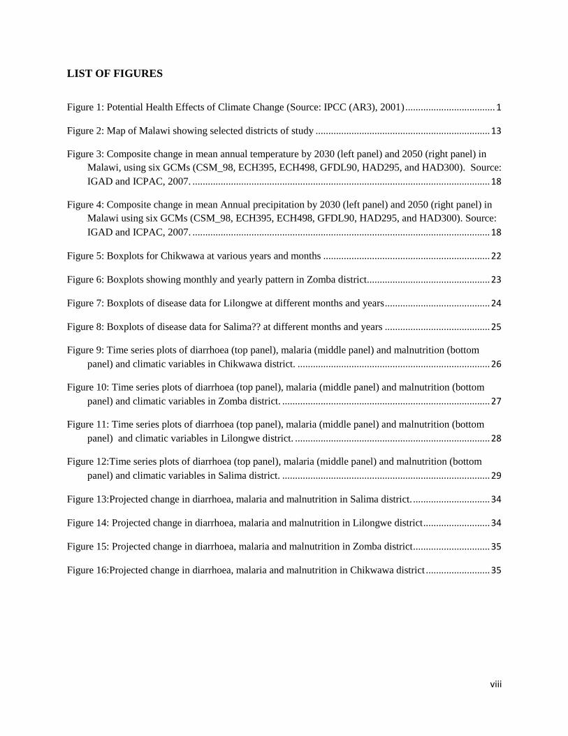
LIST OF FIGURES
Figure 1: Potential Health Effects of Climate Change (Source: IPCC (AR3), 2001) ................................... 1
Figure 2: Map of Malawi showing selected districts of study .................................................................... 13
Figure 3: Composite change in mean annual temperature by 2030 (left panel) and 2050 (right panel) in
Malawi, using six GCMs (CSM_98, ECH395, ECH498, GFDL90, HAD295, and HAD300). Source:
IGAD and ICPAC, 2007. .................................................................................................................... 18
Figure 4: Composite change in mean Annual precipitation by 2030 (left panel) and 2050 (right panel) in
Malawi using six GCMs (CSM_98, ECH395, ECH498, GFDL90, HAD295, and HAD300). Source:
IGAD and ICPAC, 2007. .................................................................................................................... 18
Figure 5: Boxplots for Chikwawa at various years and months ................................................................. 22
Figure 6: Boxplots showing monthly and yearly pattern in Zomba district ................................................ 23
Figure 7: Boxplots of disease data for Lilongwe at different months and years ......................................... 24
Figure 8: Boxplots of disease data for Salima?? at different months and years ......................................... 25
Figure 9: Time series plots of diarrhoea (top panel), malaria (middle panel) and malnutrition (bottom
panel) and climatic variables in Chikwawa district. ........................................................................... 26
Figure 10: Time series plots of diarrhoea (top panel), malaria (middle panel) and malnutrition (bottom
panel) and climatic variables in Zomba district. ................................................................................. 27
Figure 11: Time series plots of diarrhoea (top panel), malaria (middle panel) and malnutrition (bottom
panel) and climatic variables in Lilongwe district. ............................................................................ 28
Figure 12:Time series plots of diarrhoea (top panel), malaria (middle panel) and malnutrition (bottom
panel) and climatic variables in Salima district. ................................................................................. 29
Figure 13:Projected change in diarrhoea, malaria and malnutrition in Salima district. .............................. 34
Figure 14: Projected change in diarrhoea, malaria and malnutrition in Lilongwe district .......................... 34
Figure 15: Projected change in diarrhoea, malaria and malnutrition in Zomba district .............................. 35
Figure 16:Projected change in diarrhoea, malaria and malnutrition in Chikwawa district ......................... 35
ix
ABBREVIATIONS AND ACRONYMS
ADMARC Agriculture Development and Marketing Corporation
AIDS Acquired Immune Deficiency Syndrome
BRACE Building Resilience Against Climate Effects
CDC Centre for Disease Control
CHAM Christian Health Association of Malawi
COP Conference of the Parties
DHO District Health Officer
DHS Demographic and Health Survey
EHP Essential Health Package
ENSO El Nino Southern Oscillation
GCM General Circulation Model
GDP Gross Domestic Product
GFCS Global Framework on Climate Services
GHG Greenhouse Gases
GIS Geographical Information Systems
GIZ German Cooperation Agency
GoM Government of Malawi
HDP Health Development Partners
HH Household
HIV Human Immuno-deficiency Virus
HMIS Health Management Information System
HSSP Health Sector Strategic Plan
ICPAC IGAD Climate Prediction and Application Centre
IGAD Intergovernmental Authority in Development
INC Initial National Communication
INDC Intended Nationally Determined Contribution
x
IPCC Intergovernmental Panel on Climate Change
ITCZ Inter Tropical Convergence Zone
MDG Millennium Development Goals
MGDS Malawi Growth and Development Strategy
MoAIWD Ministry of Agriculture Irrigation and Water Development
MoFEP&D Ministry of Finance, Economic Planning and Development
MoH Ministry of Health
NAMA Nationally Appropriate Mitigation Actions
NAP National Adaptation Plan
NAPA National Adaptation Programmes of Action
NCD Non-communicable Diseases
NGO Non-Governmental Organization
NMCP National Malaria Control Program
NSO National Statistical Office
NTD Neglected Tropical Diseases
STDs Sexually Transmitted Diseases
SNC Second National Communication
STD Sexually Transmitted Diseases
SWAp Sector Wide Approach
TB Tuberculosis
UNDP United Nations Development Programme
UNEP United Nations Environmental Programme
UNFCCC United Nations Framework Convention on Climate Change
VCT Voluntary Counselling and Testing
WHO World Health Organisation

xi
GLOSSARY OF TERMINOLOGY
(Source: IPCC 4th
Assessment Report, 2007)
Adaptation
Initiatives and measures to reduce the vulnerability of natural and human systems against actual
or expected climate change effects. Various types of adaptation exist, e.g. anticipatory and
reactive, private and public, and autonomous and planned. Examples are raising river or coastal
dikes, the substitution of more temperature-shock resistant plants for sensitive ones, etc.
Anthropogenic emissions
Emissions of greenhouse gases, greenhouse gas precursors, and aerosols associated with human
activities, including the burning of fossil fuels, deforestation, land-use changes, livestock,
fertilisation, etc.
Carbon dioxide (CO2)
A naturally occurring gas, also a by-product of burning fossil fuels from fossil carbon deposits,
such as oil, gas and coal, of burning biomass and of land use changes and other industrial
processes. It is the principal anthropogenic greenhouse gas that affects the Earth’s radiative
balance. It is the reference gas against which other greenhouse gases are measured and therefore
has a Global Warming Potential of 1.
Carbon sequestration
The uptake of carbon containing substances by a reservoir, in particular carbon dioxide.
Climate model
A numerical representation of the climate system based on the physical, chemical and biological
properties of its components, their interactions and feedback processes, and accounting for all or
some of its known properties. The climate system can be represented by models of varying
complexity, that is, for any one component or combination of components a spectrum or
hierarchy of models can be identified, differing in such aspects as the number of spatial
dimensions, the extent to which physical, chemical or biological processes are explicitly
represented, or the level at which empirical parametrisations are involved. Coupled Atmosphere-
Ocean General Circulation Models (AOGCMs) provide a representation of the climate system
that is near the most comprehensive end of the spectrum currently available.
Climate scenario
A plausible and often simplified representation of the future climate, based on an internally
consistent set of climatological relationships that has been constructed for explicit use in
investigating the potential consequences of anthropogenic climate change, often serving as input
to impact models.
Extreme weather event
An event that is rare at a particular place and time of year. Definitions of “rare” vary, but an
extreme weather event would normally be as rare as or rarer than the 10th or 90th percentile of
the observed probability density function.
xii
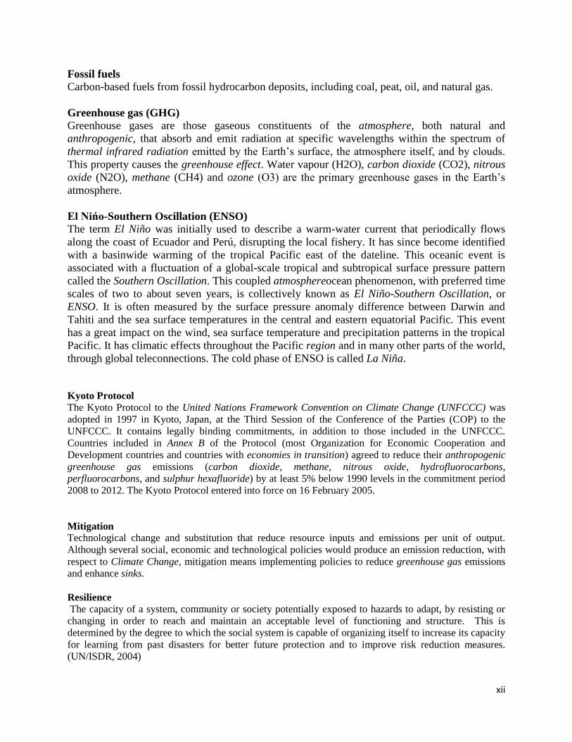
Fossil fuels
Carbon-based fuels from fossil hydrocarbon deposits, including coal, peat, oil, and natural gas.
Greenhouse gas (GHG)
Greenhouse gases are those gaseous constituents of the atmosphere, both natural and
anthropogenic, that absorb and emit radiation at specific wavelengths within the spectrum of
thermal infrared radiation emitted by the Earth’s surface, the atmosphere itself, and by clouds.
This property causes the greenhouse effect. Water vapour (H2O), carbon dioxide (CO2), nitrous
oxide (N2O), methane (CH4) and ozone (O3) are the primary greenhouse gases in the Earth’s
atmosphere.
El Nińo-Southern Oscillation (ENSO)
The term El Niño was initially used to describe a warm-water current that periodically flows
along the coast of Ecuador and Perú, disrupting the local fishery. It has since become identified
with a basinwide warming of the tropical Pacific east of the dateline. This oceanic event is
associated with a fluctuation of a global-scale tropical and subtropical surface pressure pattern
called the Southern Oscillation. This coupled atmosphereocean phenomenon, with preferred time
scales of two to about seven years, is collectively known as El Niño-Southern Oscillation, or
ENSO. It is often measured by the surface pressure anomaly difference between Darwin and
Tahiti and the sea surface temperatures in the central and eastern equatorial Pacific. This event
has a great impact on the wind, sea surface temperature and precipitation patterns in the tropical
Pacific. It has climatic effects throughout the Pacific region and in many other parts of the world,
through global teleconnections. The cold phase of ENSO is called La Niña.
Kyoto Protocol
The Kyoto Protocol to the United Nations Framework Convention on Climate Change (UNFCCC) was
adopted in 1997 in Kyoto, Japan, at the Third Session of the Conference of the Parties (COP) to the
UNFCCC. It contains legally binding commitments, in addition to those included in the UNFCCC.
Countries included in Annex B of the Protocol (most Organization for Economic Cooperation and
Development countries and countries with economies in transition) agreed to reduce their anthropogenic
greenhouse gas emissions (carbon dioxide, methane, nitrous oxide, hydrofluorocarbons,
perfluorocarbons, and sulphur hexafluoride) by at least 5% below 1990 levels in the commitment period
2008 to 2012. The Kyoto Protocol entered into force on 16 February 2005.
Mitigation
Technological change and substitution that reduce resource inputs and emissions per unit of output.
Although several social, economic and technological policies would produce an emission reduction, with
respect to Climate Change, mitigation means implementing policies to reduce greenhouse gas emissions
and enhance sinks.
Resilience
The capacity of a system, community or society potentially exposed to hazards to adapt, by resisting or
changing in order to reach and maintain an acceptable level of functioning and structure. This is
determined by the degree to which the social system is capable of organizing itself to increase its capacity
for learning from past disasters for better future protection and to improve risk reduction measures.
(UN/ISDR, 2004)

xiii
Scenario
A plausible and often simplified description of how the future may develop, based on a coherent and
internally consistent set of assumptions about driving forces and key relationships. Scenarios may be
derived from projections, but are often based on additional information from other
sources, sometimes combined with a narrative storyline.
Sink
Any process, activity or mechanism which removes a greenhouse gas, an aerosol or a precursor of a
greenhouse gas or aerosol from the atmosphere.
Source
Source mostly refers to any process, activity or mechanism that releases a greenhouse gas, an aerosol, or
a precursor of a greenhouse gas or aerosol into the atmosphere. Source can also refer to e.g. an energy
source.
United Nations Framework Convention on Climate Change (UNFCCC)
The Convention was adopted on 9 May 1992 in New York and signed at the 1992 Earth Summit in Rio de
Janeiro by more than 150 countries and the European Community. Its ultimate objective is the
“stabilisation of greenhouse gas concentrations in the atmosphere at a level that would prevent dangerous
anthropogenic interference with the climate system”. It contains commitments for all Parties. Under the
Convention, Parties included in Annex I (all OECD member countries in the year 1990 and countries with
economies in transition) aim to return greenhouse gas emissions not controlled by the Montreal Protocol
to 1990 levels by the year 2000. The Convention entered in force in March 1994.
Vulnerability
Vulnerability is the degree to which a system is susceptible to, and unable to cope with, adverse effects of
climate change, including climate variability and extremes. Vulnerability is a function of the character,
magnitude, and
rate of climate change and variation to which a system is exposed, its sensitivity, and its adaptive
capacity.

1
1.0 BACKGROUND
There is ample scientific evidence that climate change is real and that anthropogenic activities, in
particular emissions of greenhouse gases (GHGs), are its principal cause (Boko, et al., 2007;
Epstein, 2002; Smith, 2001; IPCC, 2007a). The world’s poorest countries, mainly in sub-Saharan
Africa, are most vulnerable to impacts of climate change because of their weak economies and
adaptive capacities. Thus, failure to respond to this phenomenon will stall and reverse efforts to
reduce poverty (Tadross, et al., 2009)
Ways in which climatic factors affect the prevalence of diseases or human health are complex
(Figure 1). Climate change is linked to increases in a wide range of non-communicable as well as
infectious diseases such as vector and water borne diseases, and malnutrition. Furthermore,
climate change has the potential to cause heat waves, floods, droughts, and storms, resulting in
increased deaths, injury, and changing disease scenarios. Identification of communities and
places vulnerable to these changes can help health authorities assess and prevent associated
adverse impacts on human health. These adverse impacts can be averted by putting in place a
combination of strategies such as strengthening key health system functions and improving the
use of early warning systems for climate and weather information for planning and climate risk
management.
Figure 1: Potential Health Effects of Climate Change (Source: IPCC (AR3), 2001)

2
Climate change poses a serious threat to Malawi’s development agenda (UNDP, 2010). In the
short to medium term, climate change will significantly affect the functioning of natural
ecosystems, with serious repercussions on weather‐sensitive sectors, such as agriculture, forestry,
water resources, energy, fisheries, and wildlife; as well as human health, human settlements, and
gender (GoM, 2010; GoM, 2011; Oxfam International, 2009) In the long-term, climate change
will undermine the attainment of Sustainable Development Goals (SDGs), Vision 2020, and the
Malawi Growth and Development Strategy (MGDS II), thereby exacerbating poverty in the
country.
In view of the above and in line with global efforts, the Government of Malawi signed and
ratified the United Nations Framework Convention on Climate Change (UNFCCC) in June 1992
and April 1994, respectively. In addition to ratifying the UNFCCC, the Government ratified the
Kyoto Protocol in October 2001, and submitted the Initial National Communication (INC) and
Second National Communication (SNC) reports to the Conference of the Parties (COP) of the
UNFCCC in 2002 and 2011, respectively (GoM, 2002; GoM, 2011). In 2006, the Malawi
Government developed the National Adaptation Programmes of Action (NAPA) to address short
to medium-term impacts of climate change on the country’s social and economic sectors (GoM,
2006). The Government of Malawi recognized Climate Change, Environment and Natural
Resources Management as one of the Key Priority Areas (KPA) in the Malawi Growth and
Development Strategy (GoM, 2011 b). At the moment, the Government is developing the
Climate Change Policy and the Nationally Appropriate Mitigation Actions (NAMAs) and
National Adaptation Plans (NAPs), and has also conducted a review of the National Adaptation
Programme of Action (NAPA) and developed the Intended Nationally Determined Contributions
(INDC). It is worth noting that the health sector has lagged behind in the implementation of
adaptation measures for averting the adverse impacts of climate change in Malawi.
The Ministry of Health (MoH) in Malawi is taking bold steps to address climate change risks to
human health and develop adaptation mechanisms. These efforts are attested by the MoH’s
participation in the Africa Adaptation Program of the Global Framework for Climate Services
(GFCS). The ministry plans to work with multiple sectors to improve understanding and
readiness for the health risks of climate change and variability. An initial activity of this project
involved conducting a nationwide assessment of the potential vulnerabilities and adaptation
mechanisms to impacts of climate change. To this end, the MoH commissioned a study on
Health and Climate Vulnerability and Adaptation Assessment with financial support from the
German Development Cooperation (GIZ) through the World Health Organization (WHO).
1.1. Vulnerability and Adaptation Assessment of the Health Sector to Climate Change
The main benefit derived from a vulnerability and adaptation assessment is that it allows health
authorities to understand the people and places in their jurisdiction that are more susceptible to
adverse health impacts associated with the climate-related exposures modified by climate
change. An assessment of vulnerability and adaptive capacity is a means of prioritising and
directing action where it is needed most urgently by determining which regional areas and
populations are most at risk. It can thus be used to implement more targeted public health actions
to reduce harm to vulnerable communities.

3
Vulnerability may be defined as the degree to which a system is susceptible to, and unable to
cope with adverse effects of climate change, including climate variability and extremes.
Vulnerability is a function of the character, magnitude, and rate of climate change and variation
to which a system is exposed, the sensitivity and adaptive capacity of that system, see Figure 2
(IPCC, 2007b).
Adaptation to climate change has the potential to reduce adverse impacts of climate, and enhance
the beneficial impacts, and hence enable people to continue to live their lives and participate in
developmental issues.
Figure 2: Factors that determine vulnerability (Source: CDC, Undated)
Generally, vulnerability assessments of impacts of climate change on various sectors of the
economy begin with the generation of climate change scenarios for temperature and precipitation
using General Circulation Models (GCMs), Regional Circulation Models, or Down Scaled
GCMs. These data are then used as inputs into sector specific models, e.g. water balance models
for water resources, crop models for agriculture, etc. Outputs from sector specific models are
then fed into economic models in order to assess potential impacts of climate change on the
GDP. The WHO has developed guidelines for assessing the vulnerability of the health sector to
climate change as depicted in Figure 3. Statistical models find wide application in the assessment
of the vulnerability of the health sector to adverse impacts of climate change. These models are
used to indicate the likelihood of future climate events.

4
Figure 3: Steps for Assessing Vulnerability and Adaptation of the Health Sector (WHO,
2013)
1.2. Justification
There is strong evidence that climate change is having serious repercussions on human health
worldwide. In many countries or regions, climate-sensitive diseases have increased over the
years, causing untold misery to huge human populations. The WHO Global Burden of Disease
Project (2000) estimated that climate change caused over 150,000 deaths globally and the loss of
5.5 million disability-adjusted life years from climate sensitive health outcomes (i.e. diarrheal
disease, malnutrition, malaria and floods) in the year 2000 alone. In the light of the above, there

5
is need to conduct vulnerability and adaptation assessments of the health sector if deleterious
effects of climate change are going to be avoided.
The Malawi NAPA has shown that key climate related diseases in the country are: malaria,
diarrhoea, and malnutrition. Thus, the current study was conducted with a view to assessing the
vulnerability the health sector in Malawi to adverse impacts of climate change and to
development appropriate adaptation strategies.
2.0 OBJECTIVES OF THE STUDY The main objective of the study was to assess the vulnerability of the health sector in Malawi to
impacts of climate change and to propose adaptation strategies. And the following were specific
objectives of the study:
1) To establish a baseline by determining the magnitude and distribution of the vulnerability
of the health sector to climate change and variability, with special focus on the four
priority health issues, namely: nutrition, vector-borne diseases, water-borne diseases, and
disasters (floods, drought, storms, etc.);
2) To establish a capacity-baseline of the health sector (including the community) to address
current and future risks of climate change, including the policy landscape;
3) To explore how the projected future impacts of climate change may impact the four
health priorities in Malawi;
4) To identify key indicators and risk factors to be monitored overtime to observe additional
future impacts of climate on health;
5) To identify key opportunities to bridge the identified gaps in information and capacity;
6) To identify research needs and information gaps; and
7) To develop recommendations of key national strategies and sectoral programming that
can be considered for inclusion under a climate strategy for health
3.0 SCOPE OF WORK The consultancy involved the implementation of the following tasks:
1) Developing the vulnerability and adaptation assessment protocol, and administering the
same in the selected study areas;
2) Drawing a list of key stakeholders;
3) Conducting the analysis and writing the assessment report;
4) Disseminating the findings of the assessment to key stakeholders;
5) Holding a stakeholder validation workshop to review the findings; and
6) Incorporating comments from stakeholders, and submitting the final report to the
Ministry of Health.
4.0 METHODOLOGY Approaches described in Sections 4.1 to 4.7 were employed in addressing the seven specific
objectives highlighted in Section 2.0
6
4.1 Baseline Assessment of the Vulnerability of the Health Sector In order to establish a baseline of the magnitude and distribution of the vulnerability of the health
sector to climate change and variability, with regards to nutrition, vector-borne diseases, water-
borne diseases, and disasters (floods, drought, storms, etc.), literature review of existing
documents on climate change and human health in Malawi, particularly the NAPA, and
stakeholder consultations with District Health Officers (DHOs) for Karonga, Chikwawa, Zomba,
Mangochi, Mchinji, Ntcheu, and Kasungu Districts through a questionnaire survey were
employed for data collection. These were complemented by information obtained from the
HSSP 2011-2016, the MDG Endline Survey 2014 report, and the Service Provision Survey of
2014. Baseline data on flood and drought disasters were collected from the Departments of
Disaster Management Affairs, Climate Change and Meteorological Services, and Water
Resources.
Baseline data on the use of Local Indigenous Knowledge Systems and Practices (LIKSP) for
diagnosing and treating climate related diseases was conducted in Chikwawa and Nsanje
Districts covering more than ten villages. Additionally, the application of LIKSP in predicting
the occurrence of floods and droughts was assessed.
4.2 Baseline Assessment of the Capacity to Address Climate Change
In order to establish a capacity-baseline of the health sector (including the community) to address
current and future risks of climate change, including the policy landscape, a semi-structured
questionnaire was administered to DHOs with a view to establishing the existence of capacity to
manage the key climate sensitive diseases identified in the NAPA. Additionally, their capacity to
understand climate change science and related issues, financial and institutional capacity to cope
with the adverse impacts of climate change, and the existence as well as application of early
warning systems for diseases and extreme climatic weather events, namely floods and droughts
was assessed. The information obtained from the questionnaire survey was complemented with
literature review involving the NAPA, NAP and INDC.
4.3 Vulnerability Assessment
This task was done in two stages. Firstly, climate change scenarios of temperature and
precipitation were generated using General Circulation Models. Secondly, data on climate
change scenarios for temperature and precipitation were applied in the statistical modelling of
future scenarios of the selected diseases, namely: malnutrition, malaria, and diarrhoeal diseases.
The task of generating climate change scenarios of temperature and precipitation involved the
application of an ensemble of General Circulation Models (GCMs) for the entire country (GoM,
2011; GoM, 2002). This was complemented by results presented by the IPCC in its Fourth
Assessment Report (IPCC, 2007a), the UNDP Report (McSweeney, New, & Lizcano, 2008),
Intergovernmental Authority in Development (IGAD) and ICPAC (IGAD Climate Prediction
and Application Centre) report of 2007.
After the generation of climate change scenarios of temperature and precipitation, univariate
analysis was conducted for each of the selected disease and climatic variables with cross-
correlation analysis in order to assess associations between malaria, malnutrition, dysentery,

7
cholera and climatic variables, together with other covariates over a range of time lags. The time
lags chosen for the final model simulation were outcomes of cross-correlational analysis using
seasonally differenced data.
A dynamic linear model (DYLM) model, which is equivalent to the seasonal autoregressive
integrated moving average (SARIMA), was then applied to examine independent contributions
of malaria, dysentery, or cholera transmission covariates. The number of terms for SARIMA
were determined using the autocorrelation function (ACF) and partial autocorrelation function
(PACF). When fitting the SARIMA model, the outcome variables were transformed using
Johnson and Wichern (1998) approach. For the cholera outcome, a square root transformation to
account for zero-inflation was used while logarithmic transformation was employed for malaria,
malnutrition and dysentery.
To create an appropriate stationary time series for the analysis, all dependent and independent
variables were differenced at an appropriate lag periodicity. For malaria and dysentery, lags at
month 1 and 2 were created while for cholera constructed seasonally adjusted lags of 12 months
were applied. For malnutrition, lags at 6 and 12 months were created, guided with the prior belief
that most of malnutrition cases in Malawi might be due to chronic under-nutrition (stunting) and
seasonal undernutrition (wasting).
Data on climatic variables (temperature and rainfall) and number of cases of key diseases were
collected from the Department of Climate Change and Meteorological Services (from
meteorological stations at Chikwawa, Makoka, Chitedze and Salima) and Ministry of Health -
Health Management Information System (HMIS), respectively. These data were then correlated with
a view to exploring exiting relationships.
Furthermore, future projections of climate change scenarios obtained from the IPCC Fourth
Assessment Report of 2007 were used to determine the future impacts on the key diseases using
statistical modelling for the periods 2030 and 2050. (McSweeney, New, & Lizcano, 2008)
Annual excess incidence of disease attributable to future climate-related changes in temperature
and precipitation was estimated by
∆𝑖𝑛𝑐 = 𝑖𝑛𝑐0(𝑒𝛽∆𝑋 − 1)
where ∆𝑖𝑛𝑐 is the expected incidence change due future climatic change ∆𝑋 (as provided in
Table 5), while 𝑖𝑛𝑐0 is the baseline incidence at the present time. Here, the relative risk captures
the expected change in disease risk following a 1o Celsius change in temperature or 1% change
in rainfall. The average incidence in 2007 was used as a baseline incidence to calculate future
incidence.
4.4 Indicators and Risk Factors for Tracking Climate Change Impacts on the Health Sector
1) This involved the identification of key indicators for use in tracking the disease burden (
e.g. proportion of disease cases) and their spatial distribution, as well as noting the
8
frequency and magnitude of flood and drought disasters, and noting investments in
capacity building.
2) To identify key opportunities to bridge the identified gaps in information and capacity;
3) To identify research needs and information gaps; and
4) To develop recommendations of key national strategies and sectoral programming that
can be considered for inclusion under a climate strategy for health
4.5 Identification of Opportunities for Bridging Gaps in Information and Capacity
This involved synthesising data collected through desk/literature review and stakeholder
consultations. Opportunities were then identified for bridging gaps in information and capacity.
Existing institutional structures, EAD as key focal point of CC, what is on the ground (policy,
capacity, etc) and identify weaknesses, and then this will lead to the identification of actions to
be implemented – where are the problems, positives that are existing that we need to take
advantage of the existing opportunities. Those not exiting will result in research formulation.
4. 6 Identification of Research Needs and Information Gaps
Research needs were identified through results obtained for Sections 4.1-4.5. This involved
comprehensive review of literature, consultation with key stakeholders, data collection and
analysis and statistical modelling.
4.7 Identification of Potential Adaptation Strategies
After the assessment of the health sector to impacts of climate change, potential anticipatory
adaptation strategies were proposed for implementation.
4. 8 Monitoring and Evaluation
The strategy will be to use the existing government M&E structures. The Department of
Economic Planning and Development has the overall mandate.
4. 9 Development of Recommendations of Key National Strategies and Sectoral
Programming
The compilation of recommendations made by this study was based on the findings for Sections
4.1 to 4.8
9
5.0 STUDY FINDINGS Discussed in this section are the findings of the study.
5.1 Baseline Assessment of the Vulnerability of the Health Sector Results obtained from the literature review show that during the implementation of the Malawi
Growth and Development Strategy (MGDS), Malawi registered a number of achievements
including a reduction in infant mortality rate from 76 per 1,000 in 2004 to 53 per 1,000 in 2015;
under five mortality rate from 133 per 1,000 in 2004 to 85 per 1,000 in 2015; maternal mortality
rate from 984 per 100,000 in 2004 to 574 per 100,000 in 2015; and HIV prevalence from 11.8
percent in 2004 to 10.5 percent in 2014 (NSO, 2015). Additionally, there has been a decline in
malaria prevalence from 43 percent in 2010 to 28 percent in 2012 (NSO, 2015). Also, there has
been an increase in TB cure rate from 74 percent in 2004 to 86 percent in 2014 (NSO, 2015) and
an increase in the proportion of births attended by skilled health personnel from 38 percent in
2004 to 87.4 percent in 2015.
Notwithstanding the achievement highlighted above, the country still faces a number of
challenges, namely: high prevalence of diseases, high mortality rates, high prevalence of HIV,
high incidence of malaria cases, limited access to maternal health services, low institutional
capacity, inequitable access and utilization of EHP services, inefficiency of health care system,
high prevalence of health risk factors, inadequate supply of essential drugs, and inadequate
health infrastructure (GoM, 2011 a).
In order to adequately address health challenges and to raise the health status of all Malawians,
the Government has identified Public Health, Sanitation, Malaria and HIV and AIDS
Management as some of the key priority areas. Details of the goals, outcomes and strategies of
the health sub-theme are presented in the Malawi Growth and Development Strategy II (GoM,
2011 b).
In 2004 the Ministry of Health in conjunction with other government ministries, the private
sector, Civil Society Organizations and Health Development Partners (HDP) developed the
Sector Wide Approach (SWAp) Program to guide funding for the implementation of
interventions in the health sector for the period 2004-2010. In 2011, the Health Sector Strategic
Plan (HSSP) 2011-2016 was launched which includes the following Essential Health Package
(EHP) conditions: HIV/AIDS, ARI, Malaria, Diarrhoeal diseases, Perinatal conditions, Non
communicable diseases (NCDs) including trauma, Tuberculosis, Malnutrition, Cancers, Vaccine
preventable diseases, Mental illness and epilepsy, Neglected Tropical Diseases (NTDs) and Eye,
ear and skin infections.
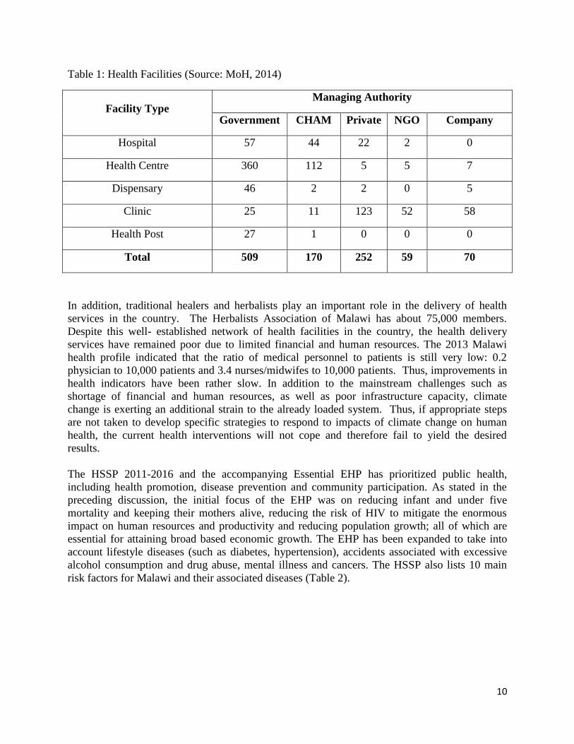
The Government of Malawi through the Ministry of Health (MoH) is the largest provider of
formal health services in the country. There are 1060 health facilities in Malawi. These are
shown in Table 1, stratified by type and managing authority.
10
Table 1: Health Facilities (Source: MoH, 2014)
Facility Type Managing Authority
Government CHAM Private NGO Company
Hospital 57 44 22 2 0
Health Centre 360 112 5 5 7
Dispensary 46 2 2 0 5
Clinic 25 11 123 52 58
Health Post 27 1 0 0 0
Total 509 170 252 59 70
In addition, traditional healers and herbalists play an important role in the delivery of health
services in the country. The Herbalists Association of Malawi has about 75,000 members.
Despite this well- established network of health facilities in the country, the health delivery
services have remained poor due to limited financial and human resources. The 2013 Malawi
health profile indicated that the ratio of medical personnel to patients is still very low: 0.2
physician to 10,000 patients and 3.4 nurses/midwifes to 10,000 patients. Thus, improvements in
health indicators have been rather slow. In addition to the mainstream challenges such as
shortage of financial and human resources, as well as poor infrastructure capacity, climate
change is exerting an additional strain to the already loaded system. Thus, if appropriate steps
are not taken to develop specific strategies to respond to impacts of climate change on human
health, the current health interventions will not cope and therefore fail to yield the desired
results.
The HSSP 2011-2016 and the accompanying Essential EHP has prioritized public health,
including health promotion, disease prevention and community participation. As stated in the
preceding discussion, the initial focus of the EHP was on reducing infant and under five
mortality and keeping their mothers alive, reducing the risk of HIV to mitigate the enormous
impact on human resources and productivity and reducing population growth; all of which are
essential for attaining broad based economic growth. The EHP has been expanded to take into
account lifestyle diseases (such as diabetes, hypertension), accidents associated with excessive
alcohol consumption and drug abuse, mental illness and cancers. The HSSP also lists 10 main
risk factors for Malawi and their associated diseases (Table 2).
11
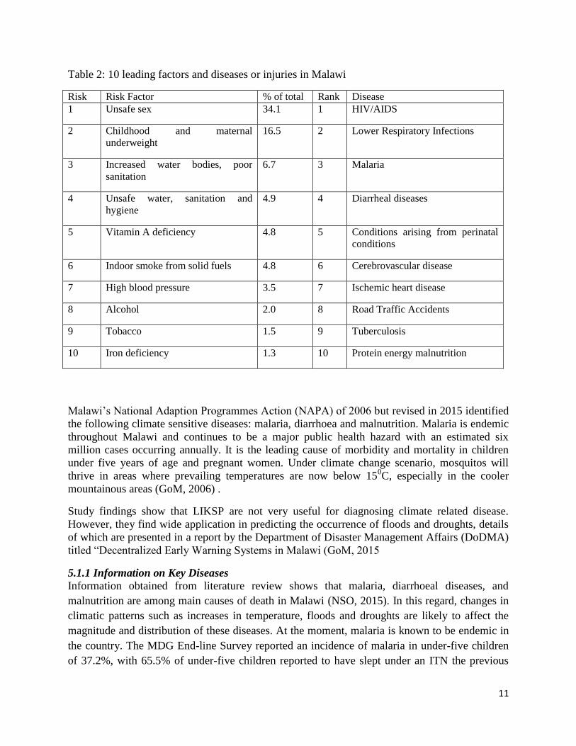
Table 2: 10 leading factors and diseases or injuries in Malawi
Risk Risk Factor % of total Rank Disease
1 Unsafe sex 34.1 1 HIV/AIDS
2 Childhood and maternal
underweight
16.5 2 Lower Respiratory Infections
3 Increased water bodies, poor
sanitation
6.7 3 Malaria
4 Unsafe water, sanitation and
hygiene
4.9 4 Diarrheal diseases
5 Vitamin A deficiency 4.8 5 Conditions arising from perinatal
conditions
6 Indoor smoke from solid fuels 4.8 6 Cerebrovascular disease
7 High blood pressure 3.5 7 Ischemic heart disease
8 Alcohol 2.0 8 Road Traffic Accidents
9 Tobacco 1.5 9 Tuberculosis
10 Iron deficiency 1.3 10 Protein energy malnutrition
Malawi’s National Adaption Programmes Action (NAPA) of 2006 but revised in 2015 identified
the following climate sensitive diseases: malaria, diarrhoea and malnutrition. Malaria is endemic
throughout Malawi and continues to be a major public health hazard with an estimated six
million cases occurring annually. It is the leading cause of morbidity and mortality in children
under five years of age and pregnant women. Under climate change scenario, mosquitos will
thrive in areas where prevailing temperatures are now below 150C, especially in the cooler
mountainous areas (GoM, 2006) .
Study findings show that LIKSP are not very useful for diagnosing climate related disease.
However, they find wide application in predicting the occurrence of floods and droughts, details
of which are presented in a report by the Department of Disaster Management Affairs (DoDMA)
titled “Decentralized Early Warning Systems in Malawi (GoM, 2015
5.1.1 Information on Key Diseases
Information obtained from literature review shows that malaria, diarrhoeal diseases, and
malnutrition are among main causes of death in Malawi (NSO, 2015). In this regard, changes in
climatic patterns such as increases in temperature, floods and droughts are likely to affect the
magnitude and distribution of these diseases. At the moment, malaria is known to be endemic in
the country. The MDG End-line Survey reported an incidence of malaria in under-five children
of 37.2%, with 65.5% of under-five children reported to have slept under an ITN the previous

12
night preceding the survey, with 60.8% of pregnant women using ITN (NSO, 2015).
Additionally, the transmission of malaria shows clear seasonal and geographical variation.
Therefore, global warming is likely to exacerbate the situation. Pregnant women and children are
most vulnerable to malaria. Adaptation measures for malaria include use of insecticide-treated
nets (ITNs) and mosquito repellents (including indigenous technologies such as use of blue gum
leaves) (GoM, 2006). It is worth noting that 80.2% of households are reported to own an ITN
(NSO, 2015).
Diarrhoeal diseases are among the major causes of illness and deaths among children under five
years of age. Children are the most vulnerable group, suffering an average of five episodes per
year. The MDG End-line survey reported an incidence of 24.1% of children having diarrheal
episode in the two weeks preceding the survey (NSO, 2015). Worth of note is the fact that of the
children that experienced diarrhoeal episode prior to the survey, 23% received ORS and zinc.
According to the NAPA (GoM, 2006)diarrhoea cases are highest during the rainy months of
December to April. Adaptation measures applied by households (HH) include boiling of drinking
water, filtration and chlorination (using Water Guard), and personal hygiene. The government offers
preventive and curative interventions in addition to public awareness campaigns.
Malnutrition is worst during the rainy season when most families have little grain left in storage
and parents are busy in their gardens. The MDG End-line Survey (NSO, 2015) reported the
following statistics for under-fives: moderate to severe underweight, 16.7%; moderate to severe
stunting, 42.4%; and moderate to severe wasting, 3.8%. Over the last ten years, the percentage of
malnutrition in children has shown no improvement (GoM, 2006). In times of food shortages,
households try to cope by engaging in casual labour in order to boost household income. Other
strategies include reducing the number and/or the size meal per day. The government encourages
crop diversification, growing of drought resistant varieties, winter cropping and irrigation
farming to enhance climate change resilience and food security at household level.
Dehydration from diarrhoea is one of the major causes of death in young children worldwide.
The prevalence of diarrhoea overall in Malawi is estimated at 17.5 %, with 38 % in children 6-12
months. The 2010 DHS showed a higher percentage of reported cases without access to
improved drinking water and sanitation. In 60% of the cases recorded, treatment was sought
from a formal health provider, and 24.2% of children under six months reportedly did not receive
any treatment at all. Under climate change scenario, diarrhoeal cases will increase where
flooding and drought conditions will prevail, resulting in outbreaks of cholera and dysentery,
respectively.
Although there has been some reduction in cases of malnutrition, the incidence of disease
remains high, with 47% of children under five stunted and 20% severely stunted. The prevalence
of diarrhoea and disease outbreaks such as measles have a significant influence on nutritional
status, particularly acute malnutrition, and have to be taken into account when interpreting

13
nutrition surveillance results. Despite the expectation that the MDG target related to nutrition
will be reached, high levels of underweight still persist. Thirteen per cent of children under five
are underweight and investments in child survival interventions such as vaccines for various
diseases, effective treatment of pneumonia at community level, and effective prevention and
treatment of malaria and diarrhoeal diseases have contributed significantly to the remarkable
decline in infant and under five mortality rates (NSO, 2015). Under climate change scenario,
malnutrition cases will increase where flooding will result in loss of crops and droughts will
cause reduced yields.
5.1.2 Profiles of Selected Project Districts
Four districts were selected for this study according to the existing project areas for WHO,
namely: Chikwawa, Zomba, Lilongwe, and Salima was included as a control (See figure 6); with
a focus on the three key diseases, namely: malaria, diarrhea (cholera and dysentery), and
malnutrition.
Figure 2: Map of Malawi showing selected districts of study
Additionally, the selected districts represented physiographic zones common in Malawi, i.e., rift
valley floor (Salima and Chikwawa Districts), plateau area (Lilongwe District), and mountainous
area (Zomba District).
Chikwawa District is located in the Lower Shire Valley in southern Malawi. It is shares
boundary with four districts, namely: Mwanza to the north, Blantyre to the northeast, Thyolo to
the east and Nsanje to the south. Chikwawa also shares an international border with Mozambique
to the west. The district headquarters is approximately 54 km away from Blantyre, the

14
Commercial City of Malawi. The total area of the district is 4,755 sq. km. The district
experiences unreliable and variable rainfall ranging from about 170 mm to 967.6 mm minimum
and maximum rainfall respectively probably because the district lies in the Shire Highland
leeward side. Temperatures are generally high with a maximum of about 37.6 °C usually
experienced in November and a minimum of 27.6 °C in July every year whilst the mean monthly
temperature is usually 25.7°C (Development Initiative Network, Undated).
The 2008 National Population and Housing Census put the estimated total population of
Chikwawa at 438,895 of which 220,914 or 50.3% is female and 217,981 or 49.7% is male.
Annual Population growth rate is estimated at 2.1% with a district average family size of 4.5.
The national population growth is 2.8% while the national average family size is 4.4. The
national population density is 139 people/km2 while the district population density is 92
people/km2. This translates that the population density at the district level is far much better than
at national level. Major diseases in the district are: malaria, eye infections, acute respiratory
infections, skin conditions, and diarrhoea. Mortality rates in the district vary from age to age,
infant mortality rate in Chikwawa is 157/1,000, and Under 5 mortality rate is 205/1,000, while
maternal mortality rate is 1200/100. The national literacy level is 80% for male and 60% for
female against district literacy level at 54.9% for males and 32.1% for females (NSO: 2015). The
major agricultural outputs of the district are livestock and crops. There are a number of cattle
ranches in the district, most of them are in Traditional Authority Ngabu. The major crops grown
in the district are maize, cotton, rice, sorghum and millet.
The district has 27 Health Posts, 11 Under Five Clinics, 3 Dispensaries, 12 Health Centres and 3
Hospitals (Chikwawa District Hospital, Ngabu Rural Hospital and Montfort Hospital). In terms
of staffing, the district has a medical doctor, nurses, clinicians, Environmental Health Officer and
Health Surveillance Assistants. Major diseases for the district are malaria, malnutrition,
diarrhoea (cholera), and TB. Malaria is the major cause of Under Five deaths in the district.
Zomba District is located in southern Malawi, and is surrounded by the districts of Chiradzulu,
Blantyre, Mulanje, Phalombe, Machinga, Balaka and the Republic of Mozambique to the east.
The total land area is 2,580 km², with a total population of 583,167 people, more than half
(52.6%) of whom are 18 years or younger. The annual population growth rate over the last
decade was two percent. (GoM, 2009)
Zomba experiences a tropical climate with three main seasons: cold‐dry, hot‐dry and hot‐wet,
ranging respectively from April to July, August to October and November to March. The hottest
months are September, October and November, with average temperatures ranging between 28
and 30 degrees Celsius. June and July are the coldest months, with minimum temperatures as
low as 10°C. The annual rainfall varies between 600mm and 1500mm (1999‐2005). On average,
February is the wettest month. More rainfall tends to fall on the windward (eastern) side of
Zomba Mountain. Areas to the west of Zomba Plateau experience little rainfall throughout the
year, as they are located on the leeward side.(GoM, 2009)
Health services in Zomba are provided mainly at health posts, clinics, health centres and
hospitals. In addition, many people get medical treatment from traditional practitioners and
15
traditional birth attendants. The crude birth rate for the District is estimated at 48.1 births per
1,000 Inhabitants. The total fertility rate stands at 5.3 children per woman. The infant mortality
rate is 84 deaths per 1,000 live births and child mortality (14.4%) is among the highest in the
country. Almost four fifth of all households (79.6%) have access to safe drinking water, while
access to sanitation facilities is still at 59%. Methods of refuse disposal include burning, dust
bins, rubbish pits, random littering and, mainly for organic waste, integrating into garden and
composite pits.
Salima district is located in the Central Region of Malawi, 103 km south of Lilongwe. It has a
total land area of 2,196 km2 or 2.3% of Malawi’s land area. It shares boundaries with Nkhotakota
to the north, Dowa and Ntchisi to the north-west, Lilongwe to the west, Dedza and Mangochi to
the south, and Lake Malawi to the East. The district has a population of about 309,300 based on
2.5% annual growth projections from the 1998 Population and Housing Census, 57.3% of this
population is in the poverty bracket of subsisting on MK16,125 per capita /year while 25% is on
MK10,029 per capita/ year against the national standards of 52.4% and 22% respectively (GoM,
Undated).
The district has a compliment of 1 District Hospital, 12 Health Centers, 4 Dispensaries, and 59
outreach clinics with a total bed occupancy rate of 257. 168 beds out of these are at the district
hospital which has equipment for minor and major surgery, dental surgery, diagnostic x-ray, and
laboratory and voluntary counselling and testing (VCT) services. It also has facilities for a range
of preventive, curative, rehabilitative services as well as and management support. Players in this
sector include government’s ministry of health, Malawi Defence Force, Agriculture Development
and Marketing Corporation (ADMARC), Christian Health Association of Malawi (CHAM), and the
private sector. In spite of concerted efforts by stakeholders to improve the delivery of quality
services thereby improving the quality of life, access continues to be a challenge. Only 278
medical personnel are available against the required establishment of 358 representing just over
77%. The most substantial critical human resource shortfall however is in the nursing profession
where only 70 out of the 152 established positions are filled representing only 46%.
Geographically, all Traditional Authority areas except Pemba and Msosa have health facilities of
up to dispensary designation. This translates into only 60% of the district population having
access to basic health services. 29% of this population spend almost 1 hour of walking time to
access health services. While 42% take more than 2 hours of walking distance to get to the
nearest health facility. The impact of this situation is a stagnating life expectancy at 39 years of
age which is aggravated by less impressive health indicators in comparison with the national
average, viz: Infant Mortality Rate at 132/1000; Under-five Mortality
Rate at 240/1000; Maternal Mortality Rate at 612/100,000 against 113/1000; 204/1000; and
980/100,000 respectively. Major cases of mortality and morbidity for the district continue to be
malaria, upper respiratory infections, anaemia, and opportunistic infections as a result of
HIV/AIDS. But for children U-5 of age, are malaria, pneumonia, anaemia, and nutritional
deficiencies. HIV/AIDS prevalence rate is at 18% against the national average of 12%. The
percentage of children less than 1 year of age fully immunized is 56% while the national
coverage stands at 70%. Under-5 children suffering effects of malnutrition is unacceptably high
at 10% against the national incidence which is 2%.
16
Lilongwe District is located in the plateau area in the Central Region. Mean temperature ranges
from 20-22.5 oC while the mean rainfall value is estimated to be 800 mm/annum. Agricultural
production is the main activity in Lilongwe District, with tobacco as the dominant crop. Health
services in the district are provided at three kevels, namely: primary, secondary, and tertiary. At
primary level, services are delivered through rural hospitals, health centres, health posts,
outreach clinics, and community initiatives. District and CHAM hospitals provide secondary
level care while tertiary level care is provided by hospitals similar to those at secondary level but
along with specialized surgical and medical facilities. Common diseases include: malaria, acute
respiratory infections, diarrhoea, malnutrition, sexually transmitted diseases (STDs), tuberculosis
(TB), and HIV/AIDS (Msewa, 2005)
5.1.3 Information on Flood and Drought Disasters
Floods and droughts have been a major source of disruption to the efficient performance of
Malawi’s agro-based economy, with serious consequences on human health. On one hand, floods
have been noted to fuel the spread of malaria, cholera, schistosomiasis, and malnutrition while
on the other hand droughts have led to the increased prevalence of malnutrition, dysentery, and
scabies.
Flood disasters are attributed to high intensity rainfall that takes place in the country; and that the
availability of densely populated river banks with flat topography and degraded catchment areas
only exacerbate the severity of flood disasters. Notable flood events that Malawi has experienced
so far include the Zomba and Phalombe flash floods of 1946 and 1991, respectively. The Zomba
flash floods were caused by high intensity rainfall resulting from the joint effect of the ITCZ and
the Zomba Cyclone when 711 mm of rainfall fell in 36 hours (Water Department/UNDP, 1986),
leaving in its wake severe loss of life and serious damage to property. During the Phalombe flash
floods of 1991, 417 mm rainfall fell within a period of three days resulting in the failure of
Michesi Hill, causing severe loss of life and extensive damage to property. Severe floods
affected 15 out of 28 districts in 2015, casing 176 fatalities and displacing 230,000 people. Of
the four selected districts, Chikwawa and Salima Districts are most vulnerable to floods.
Malawi has experienced severe droughts in the past and notable among these occurred in
1948/49 and 1991/92 seasons. Nearly all the droughts that have taken place in the country have
been associated with the El Nino and Southern Oscillation (ENSO) phenomena. Recent studies
about the ENSO warm phase episode in southern Africa show the existence of two drought cells
both of which affect Malawi, mainly the southern part of the country (Eastman et al., 1996). The
first drought cell shows a path originating from Namibia but covering Botswana, Zimbabwe,
southern Zambia, northwest Mozambique and the southern part of Malawi. The second drought
cell has its center located near southern Mozambique and southern Zambia and appears to
expand outwards. This drought cell too affects Malawi, particularly the southern part of the
country. There are no signs at the moment to suggest the abetment of these drought cells and a
lull from impacting negatively on the socio-economic development of the country as evidenced
by climate change studies done in Malawi (Chavula & Chirwa, 1996). Chikwawa is the most
vulnerable districts to drought hazards out of the four study areas.

17
Disease vectors such as anopheles mosquitoes which cause malaria require minimum ambient
temperature of 15oC in order to complete their life cycles. Global warming is therefore making
those areas that were malaria free reach those critical temperature thresholds. Literally,
mosquitoes and hence malaria seem to be moving up the mountains. Higher temperatures would
also be responsible for heat wave related illnesses and health challenges.
5.2 Baseline Assessment of the Capacity to Address Climate Change
Data obtained from literature review and stakeholder consultations with seven DHOs for
Karonga, Chikwawa, Zomba, Mangochi, Mchinji, Ntcheu, and Kasungu Districts show that there
is inadequate capacity in the ministry of health to manage key climate change related diseases as
well as ability to apply early warning systems for the prediction of the diseases. For example, the
DHOs interviewed indicated that some of their frontline staff (Health Surveillance Assistants,
medical assistants, and community health nurses) have never had training in climate change
science and related issues. Further, it was reported that the ministry does not have adequate
financial and human resources to manage the three climate related diseases mentioned above.
The same applies to local communities as their capacity in climate change related issues with
respect to health is seriously lacking.
5.3 Vulnerability Assessment The discussion in this section covers the following aspects: climate change scenarios, trends and
seasonality of disease incidence, relationship between disease and climatic variable, and
vulnerability assessment.
5.3.1 Climate Change Scenarios
Recent climate trends in Malawi show a temperature increase of 0.9oC between 1960 and 2006,
an average rate of 0.21oC per decade (McSweeney et al., 2008). The increase in temperature has
been most rapid in December-January-February (DJF) and slowest in September-October-
November (SON). Daily temperature observations show an increase in the frequency of hot days
and nights in all seasons. The frequency of cold days and nights has significantly decreased in all
seasons except in SON. Observed rainfall over the country does not show statistically significant
trends. Also, there are no statistically significant trends in the extremes indices calculated using
daily precipitation observations (McSweeney et al., 2008).
Out of the four climate change scenario (IPCC AR4, 2007), the A1B scenario was selected for
the generation of climate change scenarios for the areas of study since it best describes the
energy situation in Malawi as the country has limited technological advances. The future climatic
changes in temperature and rainfall are presented in Figures 7 and 8 respectively, for the year
2030 and 2050.

18
Figure 4: Composite change in mean Annual precipitation by 2030 (left
panel) and 2050 (right panel) in Malawi using six GCMs (CSM_98,
ECH395, ECH498, GFDL90, HAD295, and HAD300). Source: IGAD and
ICPAC, 2007.
Figure 3: Composite change in mean annual temperature by 2030 (left panel)
and 2050 (right panel) in Malawi, using six GCMs (CSM_98, ECH395,
ECH498, GFDL90, HAD295, and HAD300). Source: IGAD and ICPAC,
2007.
19
In summary, mean annual temperatures are expected to rise by 0.9 to 1.1 degree in 2030, and a
further 1.6 to 2.0 degrees in 2050 (Figure 7). Mean annual precipitation is projected to change by
-1.4% to 3.3% in 2030, while in 2050 this will change by -2.2% to 6.2% (Figure 8). The
respective expected climatic change values for temperature and precipitation for Lilongwe,
Salima, Zomba and Chikwawa are presented in Table 3

20
Table 3: Climate Change Scenarios
Mean Annual Temperature Mean Annual Precipitation
District 2030 2050 2030 2050
Lilongwe 0.9 1.7 3.3 6.2
Salima 0.9 1.7 3.3 6.2
Zomba 0.9 1.6 -0.6 -1.1
Chikwawa 1.1 2.0 -1.4 -2.6
Table 4 shows the summary statistics for the observed disease cases and climate variables.
During the period of study, the average number of diarrheal cases in Chikwawa was 1242 while
malaria was 7098 and malnutrition was 272.73. The results show that diarrhoea, malaria and
malnutrition are weakly correlated with climatic variables (correlation r<0.2), except for rainfall
and diarrhea (r=0.54). In Zomba, the mean number of diarrheal cases of 1096.4 was slightly
lower than in Chikwawa district. The mean number of malaria and malnutrition cases were 9825
and 213.7 respectively. The correlation of malaria with rainfall and minimum temperature was
moderate (r=0.5), but weak for malnutrition and diarrhoea. During the period of study, Lilongwe
posted slightly higher number of cases of all disease types. The mean cases of diarrhoea was
3516 while malaria and malnutrition were 22194 and 783.4 respectively. For all diseases, the
highest correlation with climatic variables was observed between malaria and rainfall and
minimum temperature, otherwise for other diseases this was estimated at r<0.3.
In Salima, the mean cases were 585, 5259, and 162.7 for diarrhoea, malaria and malnutrition
respectively.

21
Table 4: Summary statistics of disease incidence and climatic variables in Chikwawa, Zomba,
Lilongwe and Salima districts.
District Variable Number
(months)
Mean Median Standard
deviation
Minimum Maximum
Chikwawa Diarrhoea 84 1242.0 1135 400.67 706 2701
Malaria 84 7098.0 7618 2952.86 1799 14764
Malnutrition 84 272.7 217 221.33 39 1261
Rain 84 59.6 22.20 86.87 0 391.60
Minimum Temperature 84 20.3 21.20 3.50 12.00 25.90
Maximum Temperature 84 32.9 32.90 3.11 25.20 38.60
Zomba Diarrhoea 96 1096.4 1078.0 406.01 479.0 2986.0
Malaria 180 9825.0 9286 4075.68 3260 25893
Malnutrition 132 213.7 173.0 125.75 100.0 1127.0
Rain 180 82.3 18.65 110.64 0 439.10
Minimum Temperature 180 15.9 16.75 2.86 10.40 20.80
Maximum Temperature 180 26.6 26.80 2.39 21.60 31.60
Lilongwe Diarrhoea 84 3516.0 3178 1640.02 40 7919
Malaria 84 22194 20013 12229.1 306 51999
Malnutrition 84 783.4 781.5 423.68 0 1943.0
Rain 84 69.77 15.95 98.41 0 407.80
Minimum Temperature 84 15.14 15.60 3.25 9.00 19.60
Maximum Temperature 84 27.21 27.00 2.18 22.70 32.00
Salima Diarrhoea 132 585.8 643.0 491.14 11.0 2760.0
Malaria 132 5259 5798 3271.64 393 14643
Malnutrition 132 162.7 127.0 159.14 5.0 945.0
Rain 132 96.24 8.50 153.95 0 760.70
Minimum Temperature 132 20.51 20.86 2.34 15.70 24.60
Maximum Temperature 132 29.56 29.40 2.17 24.60 34.50
5.3.2 Trends and Seasonality of Disease Incidence
Figures 9 to 12 show boxplots of the observed incidences of diarrhoea, malaria and malnutrition
in the four districts under study. These plots display the long-term trend (years) in disease
incidence, and seasonality of disease using month. Figure 8 shows monthly variation in disease
incidence in Chikwawa district, and provides evidence of strong seasonality of diarrhoea while
for malaria, highest incidence are generally in the first months of the year, which coincides with
the hot and rainy season. The trend shows the incidence of diarrhoea has been increasing while
that of malaria and malnutrition has been decreasing.
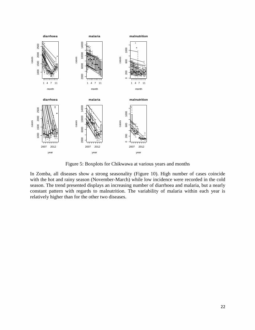
22
Figure 5: Boxplots for Chikwawa at various years and months
In Zomba, all diseases show a strong seasonality (Figure 10). High number of cases coincide
with the hot and rainy season (November-March) while low incidence were recorded in the cold
season. The trend presented displays an increasing number of diarrhoea and malaria, but a nearly
constant pattern with regards to malnutrition. The variability of malaria within each year is
relatively higher than for the other two diseases.
1 4 7 11
1000
1500
2000
2500
diarrhoea
month
cases
1 4 7 112000
6000
10000
14000
malaria
month
cases
1 4 7 11
0200
600
1000
malnutrition
month
cases
2007 2012
1000
1500
2000
2500
diarrhoea
year
cases
2007 2012
2000
6000
10000
14000
malaria
year
cases
2007 2012
0200
600
1000
malnutrition
year
cases

23
Figure 6: Boxplots showing monthly and yearly pattern in Zomba district
The trends in incidence of diarrhoea, malaria and malnutrition in Lilongwe are presented in
Figure 11. The three selected diseases show seasonality. High numbers of reported cases were
recorded in January and February, and also in November-December, which is a rainy season,
while low incidence was recorded in the second or third quarters of the year. The clear upward
trend was visible in diarrhoea incidence while for malaria this increased for four consecutive
years (2007-2010), and decreased in subsequent years only to increase again in the year 2014.
Figure 12 shows the distribution of diarrhoea, malaria and malnutrition in Salima. All boxplots
show that in general no disease displays any evidence of seasonality, although diarrhoea and
malnutrition depict some peaks towards the beginning and end of the year. As in other districts,
the incidence of diarrhoea and malnutrition has increased since the year 2007. For malnutrition,
the trend of incidence is somewhat constant.
1 4 7 11
500
1000
2000
3000
diarrhoea
month
cases
1 4 7 11
5000
15000
25000
malaria
month
cases
1 4 7 11
200
400
600
800
malnutrition
month
cases
2007 2012
500
1000
2000
3000
diarrhoea
year
cases
2000 2008
5000
15000
25000
malaria
year
cases
2004 2010
200
400
600
800
malnutrition
yearcases

24
Figure 7: Boxplots of disease data for Lilongwe at different months and years
1 4 7 11
02000
4000
6000
8000
diarrhoea
month
cases
1 4 7 11
010000
30000
50000
malaria
month
cases
1 4 7 11
0500
1000
1500
2000
malnutrition
month
cases
2007 2012
02000
4000
6000
8000
diarrhoea
year
cases
2007 2012
010000
30000
50000
malaria
year
cases
2007 2012
0500
1000
1500
2000
malnutrition
yearcases

25
Figure 8: Boxplots of disease data for Salima at different months and years
5.3.3 Relationship between disease and climatic variables
The study investigated the existence of the relationship between disease and climatic variables.
Figure 13 to 16 show time plots of each disease and each climatic variable. The top panel shows
a plot of diarrhoea against each climatic variable while presented in the middle panel is the
relationship between malaria and climatic variables.
1 4 7 11
050
015
0025
00
diarrhoea
month
case
s
1 4 7 11
040
0080
0012
000
malaria
month
case
s
1 4 7 11
020
040
060
080
0
malnutrition
month
case
s
2004 2010
050
015
0025
00
diarrhoea
year
case
s
2004 2010
040
0080
0012
000
malaria
year
case
s
2004 2010
020
040
060
080
0
malnutrition
year
case
s

26
Figure 9: Time series plots of diarrhoea (top panel), malaria (middle panel) and malnutrition
(bottom panel) and climatic variables in Chikwawa district.
The bottom panel shows graphs of malnutrition and climatic variables. In general, there was a
strong correlation between disease and climatic variables at lags of 1 and 2. For maximum
temperature, the lag went as far as 4 months. However, there was lack of plausible
epidemiological relationship to extend the models to include lags at month 4.
Time
01
00
20
03
00
40
0
rain
fall
diarrhoea
rainfall
Chikwawa
Time
dia
rrh
oe
a c
ase
s
2008 2010 2012 2014
10
00
15
00
20
00
25
00
Chikwawa
Time
dia
rrh
oe
a c
ase
s
2008 2010 2012 2014
10
00
15
00
20
00
25
00
Time
12
14
16
18
20
22
24
26
min
_T
em
pe
ratu
re
diarrhoea
minimum temperature
Chikwawa
Time
dia
rrh
oe
a c
ase
s
2008 2010 2012 2014
10
00
15
00
20
00
25
00
Time
26
28
30
32
34
36
38
ma
x_
Te
mp
era
ture
diarrhoea
maximum temperature
Chikwawa
Time
ma
lari
a c
ase
s
2008 2010 2012 2014
20
00
40
00
60
00
80
00
10
00
01
40
00
Time
01
00
20
03
00
40
0
rain
fall
malaria
rainfall
Chikwawa
Time
ma
lari
a c
ase
s
2008 2010 2012 2014
20
00
40
00
60
00
80
00
10
00
01
40
00
Time
12
14
16
18
20
22
24
26
min
_T
em
pe
ratu
re
malaria
minimum temperature
Chikwawa
Timem
ala
ria
ca
se
s
2008 2010 2012 2014
20
00
40
00
60
00
80
00
10
00
01
40
00
Time
26
28
30
32
34
36
38
ma
x_
Te
mp
era
ture
malaria
maximum temperature
Chikwawa
Time
ma
lnu
tritio
n c
ase
s
2008 2010 2012 2014
02
00
40
06
00
80
01
00
01
20
0
Time
01
00
20
03
00
40
0
rain
fall
malnutrition
rainfall
Chikwawa
Time
ma
lnu
tritio
n c
ase
s
2008 2010 2012 2014
02
00
40
06
00
80
01
00
01
20
0
Time
12
14
16
18
20
22
24
26
min
_T
em
pe
ratu
re
malnutrition
minimum temperature
Chikwawa
Time
ma
lnu
tritio
n c
ase
s
2008 2010 2012 2014
02
00
40
06
00
80
01
00
01
20
0
Time
26
28
30
32
34
36
38
ma
x_
Te
mp
era
ture
malnutrition
maximum temperature

27
Figure 10: Time series plots of diarrhoea (top panel), malaria (middle panel) and malnutrition
(bottom panel) and climatic variables in Zomba district.
Zomba
Time
dia
rrh
oe
a c
ase
s
2000 2005 2010 2015
50
01
00
01
50
02
00
02
50
03
00
0
Time
01
00
20
03
00
40
0
rain
fall
diarrhoea
rainfall
Zomba
Time
dia
rrh
oe
a c
ase
s
2000 2005 2010 2015
50
01
00
01
50
02
00
02
50
03
00
0
TimeTime
10
12
14
16
18
20
min
imu
m te
mp
era
ture
diarrhoea
minimum temperature
Zomba
Time
dia
rrh
oe
a c
ase
s
2000 2005 2010 2015
50
01
00
01
50
02
00
02
50
03
00
0
Time
22
24
26
28
30
32
ma
xim
um
te
mp
era
ture
diarrhoea
maximum temperature
Zomba
Time
ma
lari
a c
ase
s
2000 2005 2010 2015
50
00
10
00
01
50
00
20
00
02
50
00
Time
rain
fall
malaria
rainfall
01
00
20
03
00
40
0
Zomba
Time
ma
lari
a c
ase
s
2000 2005 2010 2015
50
00
10
00
01
50
00
20
00
02
50
00
TimeTime
10
12
14
16
18
20
min
imu
m te
mp
era
ture
malaria
minimum temperature
Zomba
Time
ma
lari
a c
ase
s
2000 2005 2010 2015
50
00
10
00
01
50
00
20
00
02
50
00
Time
22
24
26
28
30
32
ma
xim
um
te
mp
era
ture
malaria
maximum temperature
Zomba
Time
ma
lnu
trtio
n c
ase
s
2000 2005 2010 2015
20
04
00
60
08
00
10
00
Time
01
00
20
03
00
40
0
rain
fall
Zomba
Time
ma
lnu
trtio
n c
ase
s
2000 2005 2010 2015
20
04
00
60
08
00
10
00
Time
10
12
14
16
18
20
min
imu
m te
mp
era
ture
malnutrition
minimum temperature
Zomba
Time
ma
lnu
trtio
n c
ase
s
2000 2005 2010 2015
20
04
00
60
08
00
10
00
Time
22
24
26
28
30
32
ma
xim
um
te
mp
era
ture
malnutrition
maximum temperature

28
Figure 11: Time series plots of diarrhoea (top panel), malaria (middle panel) and malnutrition
(bottom panel) and climatic variables in Lilongwe district.
Lilongwe
Time
dia
rrh
oe
a c
ase
s
2008 2010 2012 2014
02
00
04
00
06
00
08
00
0
Time
01
00
20
03
00
40
0
rain
fall
diarrhoea
rainfall
Lilongwe
Time
dia
rrh
oe
a c
ase
s
2008 2010 2012 2014
02
00
04
00
06
00
08
00
0
Time
10
12
14
16
18
20
min
imu
m te
mp
era
ture
diarrhoea
minimum temperature
Lilongwe
Time
dia
rrh
oe
a c
ase
s
2008 2010 2012 2014
02
00
04
00
06
00
08
00
0
Time
24
26
28
30
32
ma
xim
um
te
mp
era
ture
diarrhoea
maximum temperature
Lilongwe
Time
ma
lari
a c
ase
s
2008 2010 2012 2014
01
00
00
20
00
03
00
00
40
00
05
00
00
Time
01
00
20
03
00
40
0
rain
fall
malaria
rainfall
Lilongwe
Time
ma
lari
a c
ase
s
2008 2010 2012 2014
01
00
00
20
00
03
00
00
40
00
05
00
00
Time
10
12
14
16
18
20
min
imu
m te
mp
era
ture
malaria
minimum temperature
Lilongwe
Time
ma
lari
a c
ase
s
2008 2010 2012 2014
01
00
00
20
00
03
00
00
40
00
05
00
00
Time
24
26
28
30
32
ma
xim
um
te
mp
era
ture
malaria
maximum temperature
Lilongwe
Time
ma
lnu
tritio
n c
ase
s
2008 2010 2012 2014
05
00
10
00
15
00
20
00
Time
01
00
20
03
00
40
0
rain
fall
malnutrition
rainfall
Lilongwe
Time
ma
lnu
tritio
n c
ase
s
2008 2010 2012 2014
05
00
10
00
15
00
20
00
Time
10
12
14
16
18
20
min
imu
m te
mp
era
ture
malnutrition
minimum temperature
Lilongwe
Time
ma
lnu
tritio
n c
ase
s
2008 2010 2012 2014
05
00
10
00
15
00
20
00
Time
24
26
28
30
32
ma
xim
um
te
mp
era
ture
malnutrition
maximum temperature

29
Figure 12:Time series plots of diarrhoea (top panel), malaria (middle panel) and malnutrition
(bottom panel) and climatic variables in Salima district.
Salima
Time
dia
rrh
oe
a c
ase
s
2004 2006 2008 2010 2012 2014
05
00
10
00
15
00
20
00
25
00
Time
02
00
40
06
00
rain
fall
diarrhoea
rainfall
Salima
Time
dia
rrh
oe
a c
ase
s
2004 2006 2008 2010 2012 2014
05
00
10
00
15
00
20
00
25
00
Time
16
18
20
22
24
min
imu
m te
mp
era
ture
diarrhoea
minimum temperature
Salima
Time
dia
rrh
oe
a c
ase
s
2004 2006 2008 2010 2012 2014
05
00
10
00
15
00
20
00
25
00
Time
26
28
30
32
34
ma
xim
um
te
mp
era
ture
diarrhoea
maximum temperature
Salima
Time
ma
lari
a c
ase
s
2004 2006 2008 2010 2012 2014
02
00
06
00
01
00
00
14
00
0
Time
02
00
40
06
00
rain
fall
malaria
rainfall
Salima
Time
ma
lari
a c
ase
s
2004 2006 2008 2010 2012 2014
02
00
06
00
01
00
00
14
00
0
Time
16
18
20
22
24
min
imu
m te
mp
era
ture
malaria
minimum temperature
Salima
Timem
ala
ria
ca
se
s
2004 2006 2008 2010 2012 2014
02
00
06
00
01
00
00
14
00
0
Time
26
28
30
32
34
ma
xim
um
te
mp
era
ture
malaria
maximum temperature
Salima
Time
ma
lnu
tritio
n c
ase
s
2004 2006 2008 2010 2012 2014
02
00
40
06
00
80
0
Time
02
00
40
06
00
rain
fall
malnutrition
rainfall
Salima
Time
ma
lnu
tritio
n c
ase
s
2004 2006 2008 2010 2012 2014
02
00
40
06
00
80
0
Time
16
18
20
22
24
min
imu
m te
mp
era
ture
malnutrition
minimum temperature
Salima
Time
ma
lnu
tritio
n c
ase
s
2004 2006 2008 2010 2012 2014
02
00
40
06
00
80
0
Time
26
28
30
32
34
ma
xim
um
te
mp
era
ture
malnutrition
maximum temperature

30
5.3.4 Vulnerability Assessment
In order to test the predictive potential of the model, data for the year 2014 for prediction/
forecasting was used. The root mean square error was used to validate the model. The best fitting
model was identified and summaries are presented in Tables 5 and 6.
Table 5: Regression coefficients for Chikwawa and Zomba districts
Chikwawa Zomba
Variable Diarrhoea
(95% CI)
Malaria
(95% CI)
Malnutrition
(95% CI)
Diarrhoea
(95% CI)
Malaria
(95% CI)
Malnutrition
(95% CI)
Climatic Rainfall
(Lag0)
1.001(1.000-
1.002)
1.001(1.000-
1.001)
1.000
(1.0001-
1.0004)
1.0006
(1.0005-
1.008)
1.0003
(1.00031-
1.00037)
1.001
(1.0004-
1.002)
Rainfall
(Lag1)
1.005 (1.004-
1.006)
1.001(1.001-
1.002)
1.000
(1.0000-
1.0003)
1.0005
(1.0004-
1.0006)
1.000
(1.0002-
1.0003)
1.000
(1.0003-
1.0009)
TMin
(Lag1)
1.004 (1.002-
1.005)
0.967(0.994-
0.999)
1.037(1.01-
1.04)
0.988(0.97-
0.99)
0.953(0.94-
0.97)
1.016(1.01-
1.02)
TMin
(Lag2)
1.031(1.001-
1.004)
1.027(1.011-
1.068)
0.984(0.98-
1.01)
1.004(0.99-
1.007)
0.935(0.92-
0.94)
0.873(0.84-
0.89)
TMax
(Lag1)
1.031(1.000-
1.004)
1.04 (1.02-
1.005)
0.953 (0.94-
0.99)
1.042(1.03-
1.047)
1.013(1.01-
1.03)
0.983(0.93-
1.01)
TMax
(Lag2)
1.019(1.000-
1.002)
0.987(0.971-
0.999)
1.046 (1.03-
1.06)
1.076(1.07-
1.088)
1.071(1.035-
1.11)
1.09(1.02-
1.13)
Year 2007 1.000 1.000 1.000 1.000 1.000 1.000
2008 0.856 (0.822-
0.878)
1.150(1.12-
1.18)
0.668(0.64-
0.72)
1.474(1.44-
1.49)
1.047(1.03-
1.045)
0.980(0.96-
0.99)
2009 0.873(0.814-
0.929)
1.052(1.03-
1.08)
0.586(0.55-
0.64)
1.586(1.55-
1.61)
1.157(1.13-
1.19)
1.176(1.15-
1.195)
2010 0.864(0.855-
0.877)
0.970(0.96-
0.99)
0.643(0.62-
0.69)
1.837(1.62- 2.01)
1.248(1.21-
1.26)
1.457(1.13-
1.61)
2011 1.005(1.002-
1.008)
0.647(0.62-
0.66)
0.236(0.22-
0.25)
2.135(2.08-
2.21)
1.380(1.33-
1.42)
1.037(1.01-
1.05)
2012 1.163(1.141-
1.190)
0.434(0.42-
0.44)
0.197(0.18-
0.22)
2.028(1.93-
2.11)
0.923(0.91-
0.95)
0.951(0.89-
0.98)
2013 1.184(1.178-
1.197)
0.488(0.47-
0.50)
0.214(0.201-
0.23)
2.343(2.16-
2.55)
0.936(0.91-
0.96)
1.186(0.16-
1.21)
2014 1.075(1.057-
1.091)
0.624(0.61-
0.64)
0.197(0.188-
0.22)
2.620(2.51-
2.74)
1.488(1.42-
1.57)
2.459(2.22-
2.64)
For Chikwawa district, it was noted that the effect of rainfall positively related to all diseases at
both lag of 0 and 1 month. There was approximately 0.1% increase in diarrhoea, malaria and
malnutrition per unit percentage increase in rainfall in the current month, and 0.5% increase in
diarrhoea per percentage increase in rainfall in the previous month. Both minimum and
maximum temperatures were associated with diarrhoea, malaria and malnutrition. For malaria
and minimum temperature, results show a 4% reduction in malaria when temperature increases
by 1 degree in the previous month, while malnutrition decreases by 2% in 1 degree increase in
temperature in the past 2 months (Table 5). Across all years in Chikwawa, compared to the year
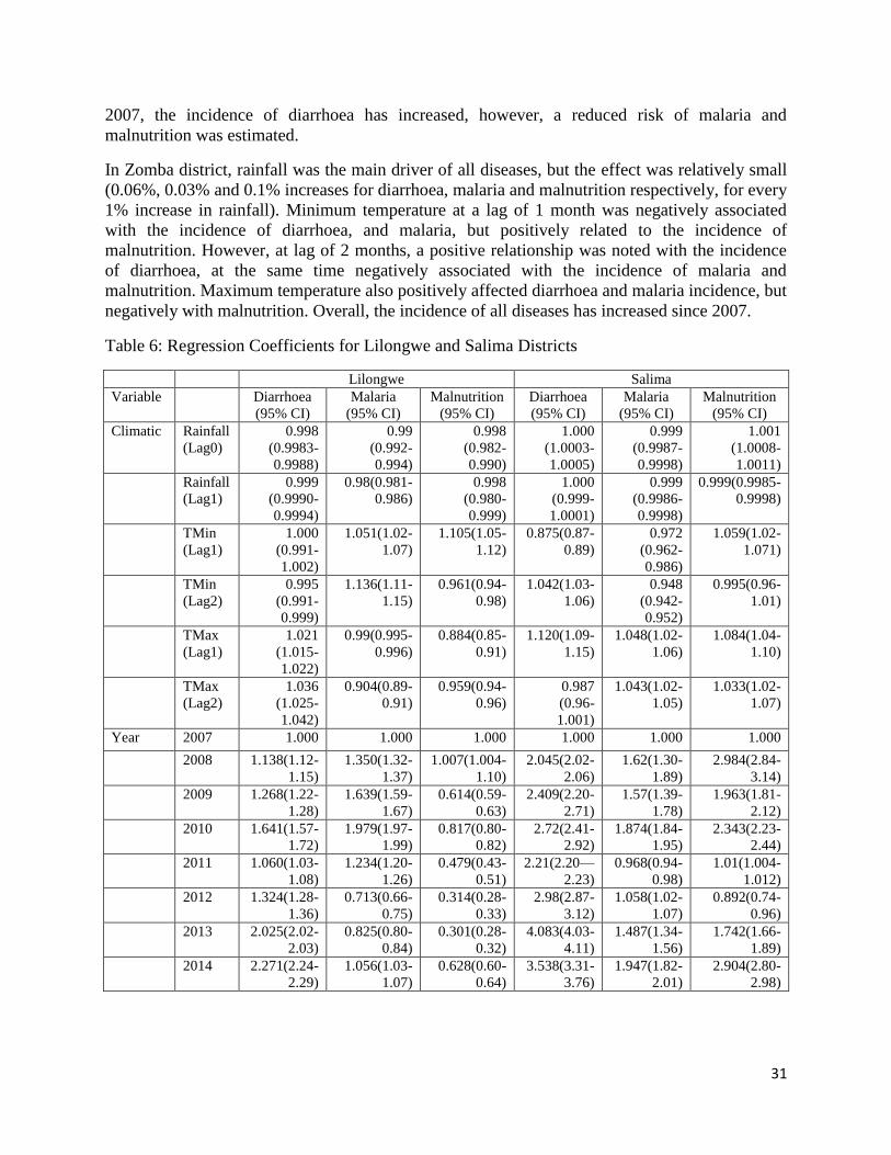
31
2007, the incidence of diarrhoea has increased, however, a reduced risk of malaria and
malnutrition was estimated.
In Zomba district, rainfall was the main driver of all diseases, but the effect was relatively small
(0.06%, 0.03% and 0.1% increases for diarrhoea, malaria and malnutrition respectively, for every
1% increase in rainfall). Minimum temperature at a lag of 1 month was negatively associated
with the incidence of diarrhoea, and malaria, but positively related to the incidence of
malnutrition. However, at lag of 2 months, a positive relationship was noted with the incidence
of diarrhoea, at the same time negatively associated with the incidence of malaria and
malnutrition. Maximum temperature also positively affected diarrhoea and malaria incidence, but
negatively with malnutrition. Overall, the incidence of all diseases has increased since 2007.
Table 6: Regression Coefficients for Lilongwe and Salima Districts
Lilongwe Salima
Variable Diarrhoea
(95% CI)
Malaria
(95% CI)
Malnutrition
(95% CI)
Diarrhoea
(95% CI)
Malaria
(95% CI)
Malnutrition
(95% CI)
Climatic Rainfall
(Lag0)
0.998
(0.9983-
0.9988)
0.99
(0.992-
0.994)
0.998
(0.982-
0.990)
1.000
(1.0003-
1.0005)
0.999
(0.9987-
0.9998)
1.001
(1.0008-
1.0011)
Rainfall
(Lag1)
0.999
(0.9990-
0.9994)
0.98(0.981-
0.986)
0.998
(0.980-
0.999)
1.000
(0.999-
1.0001)
0.999
(0.9986-
0.9998)
0.999(0.9985-
0.9998)
TMin
(Lag1)
1.000
(0.991-
1.002)
1.051(1.02-
1.07)
1.105(1.05-
1.12)
0.875(0.87-
0.89)
0.972
(0.962-
0.986)
1.059(1.02-
1.071)
TMin
(Lag2)
0.995
(0.991-
0.999)
1.136(1.11-
1.15)
0.961(0.94-
0.98)
1.042(1.03-
1.06)
0.948
(0.942-
0.952)
0.995(0.96-
1.01)
TMax
(Lag1)
1.021
(1.015-
1.022)
0.99(0.995-
0.996)
0.884(0.85-
0.91)
1.120(1.09-
1.15)
1.048(1.02-
1.06)
1.084(1.04-
1.10)
TMax
(Lag2)
1.036
(1.025-
1.042)
0.904(0.89-
0.91)
0.959(0.94-
0.96)
0.987
(0.96-
1.001)
1.043(1.02-
1.05)
1.033(1.02-
1.07)
Year 2007 1.000 1.000 1.000 1.000 1.000 1.000
2008 1.138(1.12-
1.15)
1.350(1.32-
1.37)
1.007(1.004-
1.10)
2.045(2.02-
2.06)
1.62(1.30-
1.89)
2.984(2.84-
3.14)
2009 1.268(1.22-
1.28)
1.639(1.59-
1.67)
0.614(0.59-
0.63)
2.409(2.20-
2.71)
1.57(1.39-
1.78)
1.963(1.81-
2.12)
2010 1.641(1.57-
1.72)
1.979(1.97-
1.99)
0.817(0.80-
0.82)
2.72(2.41-
2.92)
1.874(1.84-
1.95)
2.343(2.23-
2.44)
2011 1.060(1.03-
1.08)
1.234(1.20-
1.26)
0.479(0.43-
0.51)
2.21(2.20—
2.23)
0.968(0.94-
0.98)
1.01(1.004-
1.012)
2012 1.324(1.28-
1.36)
0.713(0.66-
0.75)
0.314(0.28-
0.33)
2.98(2.87-
3.12)
1.058(1.02-
1.07)
0.892(0.74-
0.96)
2013 2.025(2.02-
2.03)
0.825(0.80-
0.84)
0.301(0.28-
0.32)
4.083(4.03-
4.11)
1.487(1.34-
1.56)
1.742(1.66-
1.89)
2014 2.271(2.24-
2.29)
1.056(1.03-
1.07)
0.628(0.60-
0.64)
3.538(3.31-
3.76)
1.947(1.82-
2.01)
2.904(2.80-
2.98)

32
Table 6 shows regression estimates for Lilongwe and Salima districts. Results show that the
incidence of diarrhoea has been increasing in both Lilongwe and Salima. Diarrhoea was
negatively associated with rainfall in Lilongwe, but was positively related to rainfall in Salima. A
one degree change in maximum temperature at lag of 1 was associated with a 2% increase in
diarrhoea in Lilongwe and 12% increase in Salima. Similarly rainfall was negatively associated
with malaria and malnutrition in Lilongwe. A unit increased change in rainfall was associated
with about 1% reduction in malaria or malnutrition in Lilongwe. Current rainfall levels were
associated with increased malnutrition in Salima, with a 0.1% increase for a 1 unit increase in
rainfall. Minimum temperature at lag of 1 month was likely to increase malaria and malnutrition
risk by 5% in Lilongwe, and 13% at lag 2 for malaria only in Lilongwe. The same margin of
association of 5% was observed between minimum temperature and malnutrition in Salima.
Maximum temperature at lag 1 was also associated with a 4.8% and 8.4% increase in malaria and
malnutrition respectively.
Table 7: Composite change in mean annual temperature and rainfall by 2030 and 2050 in four
districts in Malawi under A1B scenario, using 6 GCMs (CSM_98, ECH395, ECH498, GFDL90,
HAD295, and HAD300).
Climatic variable District Expected Change
in
Year 2030
Expected Change
in
Year 2050
Temperature Chikwawa 1.1 2.0
Zomba 0.9 1.6
Lilongwe 0.9 1.7
Salima 0.9 1.7
Rain
Chikwawa -1.4 -2.6
Zomba -0.4 -1.1
Lilongwe 3.3 6.2
Salima 3.3 6.2
Source: IGAD and ICPAC, 2007.
In summary, mean annual temperatures are expected to rise by 0.9 to 1.1 degree in 2030, and a
further 1.6 to 2.0 degrees in 2050 (Table 4). Mean annual precipitation is projected to change by
-1.4% to 3.3% in 2030, while in 2050 this will change by -2.2% to 6.2%. The respective
expected changes in Lilongwe, Salima, Zomba and Chikwawa are presented in Table 5.
The rising temperatures are likely to create favourable conditions for quick maturing mosquitoes,
and may lead to increased heat-related stress. Increasing rainfall in Salima and Lilongwe may
lead to flooding, further creating a conducive environment for high transmission of disease
pathogens. Reduced rains in the southern region may result in droughts and increased incidence
of malnutrition. The projected scenarios of health-outcomes are estimated in the next season.
Figures 17 to 20 show the percentage change in disease incidence for each district under climate
change scenario. Table 6 presents a summary of changes induced by each climatic variable and
the overall change for all climatic variables.

33
Table 8: Disease incidence change in 2030 and 2050 based on projected climatic change
District Diarrhoea Malaria Malnutrition
Year 2030 Year 2050 Year
2030
Year 2050 Year
2030
Year
2050
Salima Rain 0.12 0.22 0.01 0.02 0.41 0.76
Tmin -9.71 -17.54 -4.20 -7.79 6.65 12.92
Tmax 9.66 19.21 6.68 12.98 8.95 17.58
Overall -0.88 -1.67 2.14 4.02 14.34 25.45
Lilongwe Rain -0. 09 -0.17 -0.31 -0.58 -0.49 -0.92
Tmin
1.29 2.46 6.69 13.02
4.85 9.36
Tmax 2.21 4.20 -2.46 -4.53 -9.14 -16.57
Overall 3.32 6.16 3.63 6.73 -5.47 -10.53
Zomba Rain -0.02 -0.04 0.01 0.003 -0.04 -0.12
Tmin -0.65 -1.14 -6.19 -10.74 -2.33 -4.09
Tmax 4.04 7.29 2.91 5.24 0.97 1.74
Overall 3.24 5.68 -3.58 -6.45 -1.44 -2.61
Chikwawa Rain -0.08 -0.16 -0.11 -0.18 0.03 0.06
Tmin 0.41 0.75 -3.34 -5.96 3.50 6.46
Tmax 0.03 6.24 -1.18 -2.14 -4.85 -8.65
Overall 3.59 6.41 -4.76 -8.81 -1.51 -2.76
Figure 17 shows the projected change in diarrhoea, malaria and malnutrition for Salima district.
The highest increase is estimated in malnutrition, projected at 14.3% in the year 2030 and 25.4%
in 2050. Diarrhoea was estimated to decrease by 0.9% and 1.7% in 2030 and 2050 respectively.

34
Figure 13:Projected change in diarrhoea, malaria and malnutrition in Salima district.
In Lilongwe, both diarrhoea and malaria are projected to increase (Figure 18). In 2030 diarrhoea
increases by 3.32% in 2030 and 6.16% in 2050 while malaria increases by 3.36% and 6.73% in
2030 and 2050 respectively. Malnutrition will decrease by about 5% in 2030 and a further 6% in
2050. Figure 19 shows the anticipated change in Zomba district. Only diarrhoea is estimated to
increase by 3.2 times in 2030 and 5.7 times and 2050 respectively compared to the present period
(2007-2014). Future malaria incidence will decrease by about 4%, in 2030, and 6.5% in 2050,
whereas malnutrition will decline by 1.4% and 2.6% in the two future projected periods.
Figure 14: Projected change in diarrhoea, malaria and malnutrition in Lilongwe district
-5
0
5
10
15
20
25
30
Present(2007-2014) Year 2030 Year 2050
Pe
rce
nta
ge c
han
ge
Diarrhoea Malaria Malnutrition
-12
-10
-8
-6
-4
-2
0
2
4
6
8
Present(2007-2014) Year 2030 Year 2050
Pe
rce
nta
ge c
han
ge
Diarrhoea Malaria Malnutrition

35
Figure 15: Projected change in diarrhoea, malaria and malnutrition in Zomba district
A similar pattern of change is projected for Chikwawa (Figure 20). Diarrhoea incidence will
increase by 3.6% in 2030 and 6.4% in 2050. At the same time, malaria incidence will decrease
by 4.8% and 8.8% in 2030 and 2050 respectively, while malnutrition will decrease by 1.5% and
2.8% for both 2030 and 2050 respectively.
Figure 16: Projected change in diarrhoea, malaria and malnutrition in Chikwawa district
-8
-6
-4
-2
0
2
4
6
8
Present(2007-2014) Year 2030 Year 2050
Pe
rce
nta
ge c
han
ge
Diarrhoea Malaria Malnutrition
-10
-8
-6
-4
-2
0
2
4
6
8
Present(2007-2014) Year 2030 Year 2050
Pe
rce
nta
ge c
han
ge
Diarrhoea Malaria Malnutrition
36
5.4 Indicators and Risk Factors for Tracking Climate Change Impacts on the Health Sector
Three key indicators were identified for use in monitoring and tracking climate change impacts
on human health in Malawi, namely: proportion of cases of the key diseases and their spatial
distribution, the frequency and magnitude of floods and droughts, and investment in capacity
building, i.e., human, financial, and institutional. What is clear at the moment is that all the four
districts are vulnerable to malaria, diarrhoea, and malnutrition. But although information on the
number of cases of diseases is being collected and archived in the HMIS, there is at the moment
no facility in the software to store spatial data of the same. However, it is envisaged that such a
facility will be incorporated in the new version of HMIS.
5.5 Opportunities for Bridging Gaps in Information and Capacity
Views on indigenous knowledge by the local communities on climate change and the causes of
the three diseases and their mode of treatment were sought through stakeholder consultations.
However, such information is only useful in the diagnosis of the diseases when they have already
struck their victims. Therefore there is need to establish a link between LIKSP and science
based evidence of climate change impacts and early warning systems. Also, there is very little
coordination among organizations that deal with climate change issues in Malawi, more so
between DoDMA, Ministry of Agriculture Irrigation and Water Development (MAIWD),
Department of Climate Change and Meteorological Services (DCCMS), Ministry of Health
(MoH), and various non-governmental organizations (NGOs). What are the gaps? How do we
bridge the gaps? How do we make us of the existing structures/capacities to address the gaps?
Do we need training? Ratio of HSA/population (1/1000 – recommended)
An assessment of the capacity of personnel in the Ministry of Health, local communities and
various relevant organizations in addressing the impacts of climate change on human health
shows serious shortfalls in trained personnel in the country to address climate change in
knowledge, numbers and skills. Very few professionals are conversant with climate change
science, vulnerability assessments, and adaptation to climate change, link between health events
and climate data.
5.6 Research Needs and Information Gaps
A number of research questions were identified through the study, the key ones being those listed
below:
a) Relationship between vector-borne diseases (malaria) and weather variability and climate
change in Malawi
b) Capacity of health sector in Malawi to address current and future risks related to climate
change
c) Utilization of weather and climate information in predicting health events and strategic
planning in Malawi
d) Use of indigenous knowledge and practices in health adaptation to the impact of weather
variability and climate change on health.
Other additional issues considered critical area as follows

37
1. The need to show the link between LIKSP and its applicability to climate change
prediction;
2. The need to enhance collaboration and coordination between the various sectors that deal
with climate change issues; and
3. The need to make health systems resilient to climate change.
Research in the listed areas is required to investigate underlying factors influencing the temporal
and spatial occurrence of various climate related diseases at national, district, and community
level, and lead to the development of appropriate measures for controlling such diseases.
5.7 Identification of Potential Adaptation Strategies
A wide range of adaptation measures were identified in the health sector to counter the
deleterious impacts of climate change. Most of these build on well-established public health
approaches and are therefore theoretically easy to implement. They include general measures
such as:
a) Strengthening effective surveillance and prevention programmes;
b) Sharing lessons learned across countries and sectors;
c) Introducing new prevention measures or increasing existing measures;
d) Developing new policies to address new threats;
e) Institutional mechanisms, including early-warning systems and emergency planning /
disaster preparedness schemes, training, communication, monitoring and surveillance,
and research;
f) Public education and awareness;
g) Disaster preparedness, including health system surge capacity;
h) Enhanced disease control programme; and
i) Appropriate workforce training and mid-career development
Currently, adaptation measures for malaria prevention and control include: case management,
intermittent preventive treatment of pregnant women, integrated vector management (Treated
Nets, indoor residual spraying (IRS), and environmental management), application of mosquito
repellents (including indigenous technologies such as use of blue gums). At the moment,
government through the National Malaria Control Programme (NMCP) distributes subsidised
ITNs to pregnant women and new born babies through the health facilities, and periodically
conducts mass distribution campaigns of the ITNs in order to achieve universal coverage for
malaria control. Under climate change scenario, these current methods will be up-scaled. It is
also worth noting that only a few districts in the country use indoor residual spraying due to
financial limitations. At the moment the country is not using larviciding for malaria vector
control. Because this method is not being used in Malawi, there is need to conduct an operational
research.
Adaptation measures applied by households (HH) for combating diarrheal diseases include
household water treatment and safe storage (HWTS) using products such as chlorine based
solutions, water filters, and improved hygiene and sanitation. Furthermore, the country is using
Community Led Total Sanitation (CLTS) approach in order to achieve open defaecation free

38
societies. Government also offers curative interventions in addition to conducting public
awareness campaigns for diarrheal diseases control and prevention.
Adaptation strategies for malnutrition include: community management of acute malnutrition
(CMAM), nutrition care support and treatment (NCST), promotion of infant and young child
feeding (IYCF), micronutrient supplementation – food fortification. These interventions are
provided at both health facility and community levels. In times of food shortages, households
cope by engaging in casual labour in order to boost income for buying food. Other strategies
include crop diversification, growing of drought resistant varieties, and practicing irrigated
agriculture including winter cropping.
5.8 Monitoring and Evaluation
The Department of Economic Planning and Development (DEPD) in the Ministry of Finance,
Economic Planning and Development has the overall mandate to monitor and evaluate all
government programmes and projects. However, the line ministries and respective departments
would take the responsibility of operational monitoring and evaluation, and production of annual
reports which DEPD uses to produce Annual Economic Review.
Although obvious indicators for monitoring impacts of climate change are cases of disease
outbreaks and the frequency and magnitude of floods and droughts, it is envisaged that the
ministry may use additional indicators and risk factors to consider for monitoring impacts of
climate change on human health in Malawi. Risk factors might include the non-availability of
drugs for treating the various diseases highlighted in the preceding discussion as well as
Malawi’s weak economy leading to low adaptive capacity.
In order to facilitate comparability between participating countries, it is necessary that uniform
M & E guidelines should be applied.
39
6.0 DISCUSSION OF RESULTS The study has shown that malaria, diarrhoea, and malnutrition continue to be a major public
health problem in Malawi as stated in the NAPA; notwithstanding commendable government
effort to reduce the disease burden. However, it is worth noting that although the climatic data
(i.e., temperature and rainfall) for the selected districts span over a number of years (e.g. from as
early as the 1890s), the disease data used in the correlation analysis were for the period 2004 to
present. Thus, it was not possible to gain insight into the trend of the diseases over a long period
of time, a constraint which may have masked some critical observations about the history of the
diseases in the country. This was so because the HMIS only came into existence in 2004.
However, it is clear from the graphs of climate variables plotted against the number of cases of
diseases that the three climate related diseases exhibit seasonality.
The analysis has shown that the MoH has inadequate capacity in the following areas:
management of the three climate change related diseases, climate change science and related
issues, availability of financial resources, and the institutional arrangement. Therefore there is
need to build capacity in the MoH in the areas highlighted above if the deleterious impacts of
climate change on human health are going to be avoided.
In the assessment of the vulnerability of the health sector to climate change, the study relied on
the use of climate scenarios obtained from GCMs. While these data are very useful, their area of
coverage are generally large. But now that downscaled GCMs are gaining prominence in climate
change studies, it may be necessary to conduct similar studies in future using downscaled model
results for temperature and rainfall. Also, it is critical that the HMIS incorporates a routine for
manipulating spatial data for ease of depicting the spatial distribution of the disease, without
necessarily using separate GIS software.
Although the number of cases of diseases and the frequency and magnitude of the occurrence of
floods and droughts have been selected as obvious indicators for monitoring impacts of climate
change on human health, it is envisaged that the ministry may use additional indicators and risk
factors it may deem critical for monitoring the performance of health related projects.
40
7.0 CONCLUSION Information obtained from literature review and stakeholder shows that malaria, diarrhoeal
diseases, and malnutrition are among main causes of death in Malawi. In this regard, changes in
climatic patterns such as increases in temperature, floods and droughts are expected to
exacerbate the situation. Adaptation measures for malaria include use of insecticide-treated nets
(ITNs) and mosquito repellents. Adaptation measures for diarrhoea include boiling of drinking
water or filtration and chlorination (using Water Guard), and personal hygiene. Adaptation
measures for malnutrition include: incoming generation for casual labour, crop diversification,
growing of drought resistant varieties, winter cropping and irrigation farming to enhance climate
change resilience and food security at household level.
The study has shown that there is inadequate capacity in the MoH to manage key climate change
related diseases as well as ability to apply early warning systems for the prediction of the
diseases. For example, DHOs indicated that their frontline staff (health Surveillance Assistants)
have never had training in climate change science and related issues. Further, it was reported that
the ministry does not have adequate financial and human resources to manage the three climate
related diseases mentioned above. (Action Aid, 2006)
Under climate change scenario, mean annual temperatures in Malawi are expected to rise by 0.9
to 1.1 degree in 2030, and a further 1.6 to 2.0 degrees in 2050. Mean annual precipitation is
projected to change by -1.4% to 3.3% in 2030, while in 2050 this will change by -2.2% to 6.2%.
Vulnerability assessment results show that the incidence of diarrhoea has been increasing in both
Lilongwe and Salima. Diarrhoea was negatively associated with rainfall in Lilongwe, but was
positively related to rainfall in Salima. Current rainfall levels were associated with increased
malnutrition in Salima, with a 0.1% increase for a 1 unit increase in rainfall. Minimum
temperature at lag of 1 month was likely to increase malaria and malnutrition risk by 5% in
Lilongwe, and 13% at lag 2 for malaria only in Lilongwe. The same margin of association of 5%
was observed between minimum temperature and malnutrition in Salima. Maximum temperature
at lag 1 was also associated with a 4.8% and 8.4% increase in malaria and malnutrition
respectively. (Boko, et al., 2007)
In Lilongwe, both diarrhoea and malaria are projected to increase. In 2030 diarrhoea increases by
3.32% in 2030 and 6.16% in 2050 while malaria increases by 3.36% and 6.73% in 2030 and
2050 respectively. Malnutrition will decrease by about 5% in 2030 and a further 6% in 2050.
Only diarrhoea is estimated to increase by 3.2 times in 2030 and 5.7 times and 2050 respectively
compared to the present period (2007-2014). Future malaria incidence will decrease by about
4%, in 2030, and 6.5% in 2050, whereas malnutrition will decline by 1.4% and 2.6% in the two
future projected periods.
In Chikwawa, diarrhoea incidence will increase by 3.6% in 2030 and 6.4% in 2050. At the same
time, malaria incidence will decrease by 4.8% and 8.8% in 2030 and 2050 respectively, while
malnutrition will decrease by 1.5% and 2.8% for both 2030 and 2050 respectively.
Four key indicators were selected for use in monitoring and tracking climate change impacts on
human health in Malawi, namely: number of cases of the key diseases and their spatial
41
distribution, the frequency and magnitude of floods and droughts, and investment in capacity
building, i.e., human, financial, and institutional.
Also, the report has covered issues about information gaps and the need for improved
coordination among various organizations that deal with climate change issues in Malawi, the
need to address capacity building (human, financial and institutional) in the Ministry of Health,
and critical areas of research.
Adaptation strategies for the health sector for the three key diseases have been spelt in the
NAPA, NAP, and INDC.
42
8.0 RECOMMENDATIONS
The following are the recommendations that have been developed in respect of key national
strategies and sectoral programming for the Ministry of Health:
1. Mainstream climate change in all strategic health planning, policies and programming;
2. Build local capacity in human resource, equipment and infrastructure in climate change
and human health related issues;
3. Promote coordination and collaboration between the Ministry of Health and organizations
or sectors that deal with climate change issues and ensure regular sharing of information;
4. Enhance research on the interface between climate change and human health and assess
areas such as effectiveness of current vector control measures for malaria;
5. Explore and utilize existing opportunities, including financial resource mobilization, to
address issues of climate change and human health;
6. Develop early warning systems for weather variability and climate sensitive events,
diseases and conditions and develop risk maps for vector-borne diseases that is linked to
the weather and climate data;
7. Promote public awareness on the relationship between human health and climate change;
43
REFERENCES
Action Aid. (2006). Climate Change and Smallholder Farmers in Malawi: Understanding poor people's
experiences in climate chnage adaptation. Johannesburg: Action Aid.
Boko, M., Niang, I., Nyong, A., Vogel, C., Githeko, A., Medany, M., . . . Yanda, P. (2007). Africa Climate
Change 2007: Impacts, Adaptation and Vulnerability. Contribution of Working Group II to the
Fourth Assessment Report of the Intergovernmental Panel on Climate Change. Cambridge:
Cambridge University Press.
Chavula, G., & Chirwa, A. (1996). Impacts of climate change on water resources of Malawi. 1996 RPC
Conference. Sun and Sand-Mangochi: University of Malawi.
Eastman, J., Ayamba, A., & Ramachandran, M. (1996). The spatial manifestation of ENSO warm phase
events in southern Africa. Harare.
Epstein, P. R. (2002). Climate Change and Infectious Disease: Stormy Weather Ahead? Epidemiology.
Epidemiology, Vol 13 No.4.
George, L. (2011). Climate change adaptation in the health sector: the BRACE Framework. USA: CDC.
GoM. (1998). State of the Environment Report. Lilongwe: Environmental Affairs Department.
GoM. (2002). The Initial National Communication of Malawi to the Conference of the Parties of the
United Nations Framework Convention on Climate Change. Lilongwe: Ministry of Ntural
Resources, Energy and Environment.
GoM. (2006). Malawi's National Adaptation Programme of Action . Lilongwe: Ministry of Mines, Natural
Resources and Environment.
GoM. (2010). Malawi State of Environment and Outlook Report: Environment for Suitable Economic
Growth. Lilongwe: Ministry of Natural Resources, Energy and Environment.
GoM. (2011 a). Malawi Health Sector Strategic Plan: moving towards equity and quality. Lilongwe:
Ministry of Health.
GoM. (2011 b). Malawi Growth and development Strategy II (2011-2016). Lilongwe: DEP&D.
GoM. (2011). The Second National Communication of the Republic of Malawi to the Conference of the
Parties of the United Nations Framework Convention on Climate Change. Lilongwe: Ministry of
Natural Resoures, Energy and Environment.
GoM. (2013). National Disaster Risk Management Policy. Lilongwe: Department of Disaster
Preparedness and Management.

44
IPCC. (2007a). Climate Change 2007: The Physical Science Basis. Contribution of Working Group I to the
Fourth Assessment Report of the Intergovernmental Panel on Climate Change [Solomon, S., D.
Qin, M. Manning,Z. Chen, M. Marquis, K.B. Averyt, M.Tig. London/ New York.
IPCC. (2007b). Climate change 2007: Synthesis Report, Contribution to Fourth Assessment Report. IPCC.
Johnson, R. A. (1998). Applied Multivariate Statistical Analysis . Upper Saddle River,NJ: Prentice Hall.
McSweeney, C., New, M., & Lizcano, G. (2008). UNDP Climate Change Country Profiles: Malawi. Oxford:
University of Oxford.
Oxfam International. (2009). Winds of Change: climate change , poverty and environment in Malawi.
Malawi: Joint Oxfam Programme in Malawi.
Smith, J. (2001). A Summary of Climate Impact Assessments from US Country Studies Program, Climate
Change. Netherlands: Springer.
Tadross, M., P, S., Lotsch, A., Hachigonta, S., Mdoka, M., Unganai, L., & Lucio F., K. D. (2009). Growing-
season rainfall and scenarios of future change in southeast Africa: implications for cultivating
maize. Climate Research. Climate Research, Vol 40:147-161.
UNDP. (2010). United Nations Country Assessment Report for Malawi. Lilongwe: UNDP.
WHO. (2013). 2.23. WHO, 2013, Protecting health from climate change: vulnerability and adaptation
assessment, Switzerland. Geeva: WHO.
WMO. (2003). Health and environmental change. Geneva: WMO.
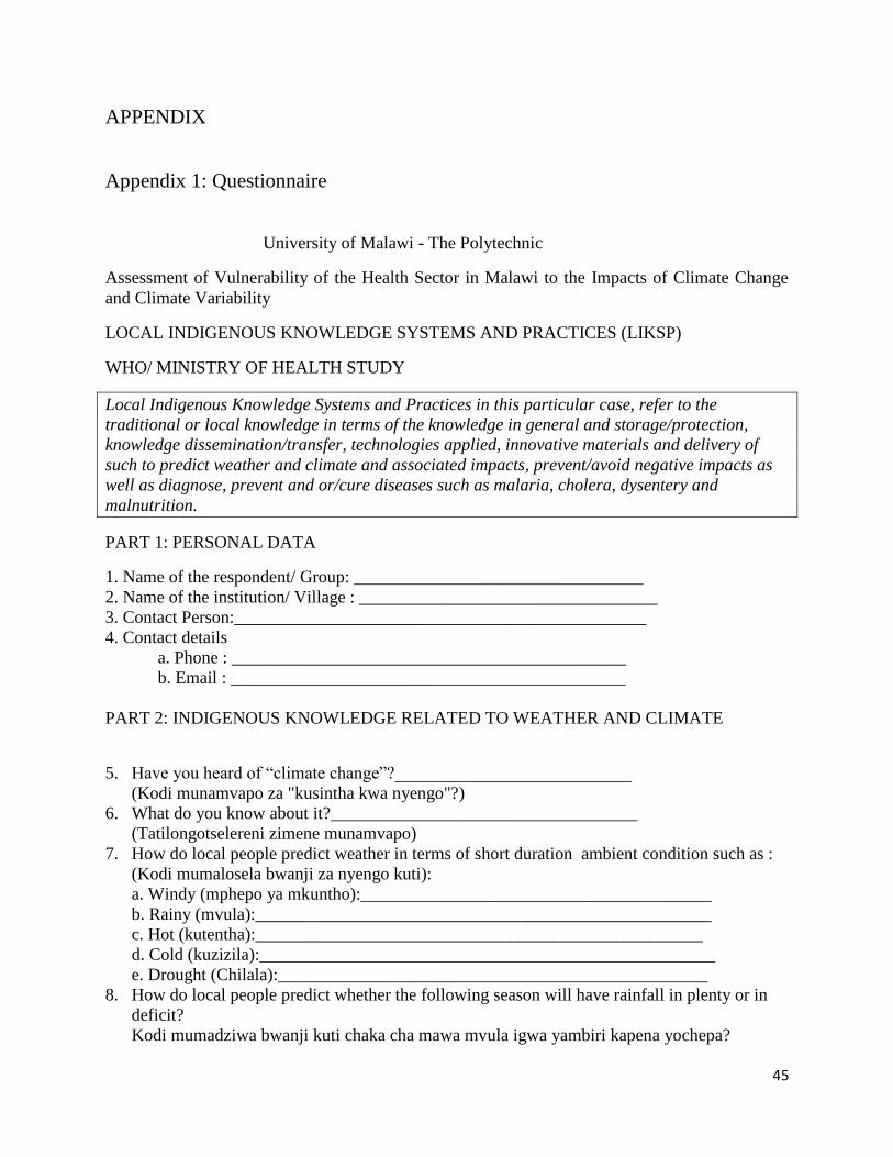
45
APPENDIX
Appendix 1: Questionnaire
University of Malawi - The Polytechnic
Assessment of Vulnerability of the Health Sector in Malawi to the Impacts of Climate Change
and Climate Variability
LOCAL INDIGENOUS KNOWLEDGE SYSTEMS AND PRACTICES (LIKSP)
WHO/ MINISTRY OF HEALTH STUDY
Local Indigenous Knowledge Systems and Practices in this particular case, refer to the
traditional or local knowledge in terms of the knowledge in general and storage/protection,
knowledge dissemination/transfer, technologies applied, innovative materials and delivery of
such to predict weather and climate and associated impacts, prevent/avoid negative impacts as
well as diagnose, prevent and or/cure diseases such as malaria, cholera, dysentery and
malnutrition.
PART 1: PERSONAL DATA
1. Name of the respondent/ Group: _________________________________
2. Name of the institution/ Village : __________________________________
3. Contact Person:_______________________________________________
4. Contact details
a. Phone : _____________________________________________
b. Email : _____________________________________________
PART 2: INDIGENOUS KNOWLEDGE RELATED TO WEATHER AND CLIMATE
5. Have you heard of “climate change”?___________________________
(Kodi munamvapo za "kusintha kwa nyengo"?)
6. What do you know about it?___________________________________
(Tatilongotselereni zimene munamvapo)
7. How do local people predict weather in terms of short duration ambient condition such as :
(Kodi mumalosela bwanji za nyengo kuti):
a. Windy (mphepo ya mkuntho):________________________________________
b. Rainy (mvula):____________________________________________________
c. Hot (kutentha):___________________________________________________
d. Cold (kuzizila):____________________________________________________
e. Drought (Chilala):_________________________________________________
8. How do local people predict whether the following season will have rainfall in plenty or in
deficit?
Kodi mumadziwa bwanji kuti chaka cha mawa mvula igwa yambiri kapena yochepa?
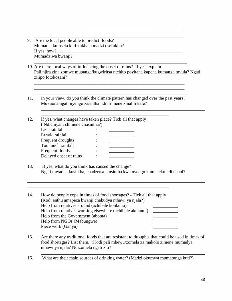
46
__________________________________________________________________
__________________________________________________________________
9. Are the local people able to predict floods?
Mumatha kulosela kuti kukhala madzi osefukila?
If yes, how?_______________________________________________________
Mumadziwa bwanji?
___________________________________________________________________
10. Are there local ways of influencing the onset of rains? If yes, explain
Pali njira zina zomwe mupanga/kugwiritsa ntchito poyitana kapena kumanga mvula? Ngati
zilipo fotokozani?
__________________________________________________________________
__________________________________________________________________
___________________________________________________________________
11. In your view, do you think the climate pattern has changed over the past years?
Mukuona ngati nyengo zasintha ndi m’mene zinalili kale?
________________________________________________________________________
________________________________________________________
12. If yes, what changes have taken place? Tick all that apply
( Ndichiyani chimene chasintha?)
Less rainfall : ___________
Erratic rainfall : ___________
Frequent droughts : ___________
Too much rainfall : ___________
Frequent floods : ___________
Delayed onset of rains : ___________
13. If yes, what do you think has caused the change?
Ngati mwaona kusintha, chadzetsa kusintha kwa nyengo kumeneku ndi chani?
______________________________________________________________________________
______________________________________________________________
14. How do people cope in times of food shortages? - Tick all that apply
(Kodi anthu amapeza bwanji chakudya nthawi ya njala?)
Help from relatives around (achibale konkuno) : ___________
Help from relatives working elsewhere (achibale akutauni) : ___________
Help from the Government (aboma) : ___________
Help from NGOs (Mabungwe) : ___________
Piece work (Ganyu) : ___________
15. Are there any traditional foods that are resistant to droughts that could be used in times of
food shortages? List them. (Kodi pali mbewu/zomela za makolo zimene mumadya
nthawi ya njala? Ndizomela ngati ziti?
________________________________________________________________________
16. What are their main sources of drinking water? (Madzi okumwa mumatunga kuti?)
__________________________________________________________________
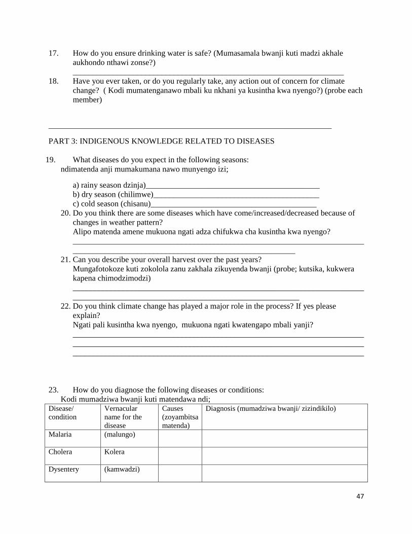
47
17. How do you ensure drinking water is safe? (Mumasamala bwanji kuti madzi akhale
aukhondo nthawi zonse?)
___________________________________________________________________
18. Have you ever taken, or do you regularly take, any action out of concern for climate
change? ( Kodi mumatenganawo mbali ku nkhani ya kusintha kwa nyengo?) (probe each
member)
______________________________________________________________________
PART 3: INDIGENOUS KNOWLEDGE RELATED TO DISEASES
19. What diseases do you expect in the following seasons:
ndimatenda anji mumakumana nawo munyengo izi;
a) rainy season dzinja)___________________________________________
b) dry season (chilimwe)_________________________________________
c) cold season (chisanu)_________________________________________
20. Do you think there are some diseases which have come/increased/decreased because of
changes in weather pattern?
Alipo matenda amene mukuona ngati adza chifukwa cha kusintha kwa nyengo?
________________________________________________________________________
_______________________________________________________
21. Can you describe your overall harvest over the past years?
Mungafotokoze kuti zokolola zanu zakhala zikuyenda bwanji (probe; kutsika, kukwera
kapena chimodzimodzi)
________________________________________________________________________
________________________________________________________
22. Do you think climate change has played a major role in the process? If yes please
explain?
Ngati pali kusintha kwa nyengo, mukuona ngati kwatengapo mbali yanji?
________________________________________________________________________
________________________________________________________________________
________________________________________________________________________
23. How do you diagnose the following diseases or conditions:
Kodi mumadziwa bwanji kuti matendawa ndi; Disease/
condition
Vernacular
name for the
disease
Causes
(zoyambitsa
matenda)
Diagnosis (mumadziwa bwanji/ zizindikilo)
Malaria (malungo)
Cholera Kolera
Dysentery
(kamwadzi)

48
Malnutrition
(kuperewera
kwa zakudya
mthupi)
24. Are there preventive and curative prescriptions for the above conditions/ diseases?
If yes, explain.
Pali njira zopewera kapena zochizira matendawa. Ngati zilipo, fotokozani? Disease/
condition
Preventive prescription (njira
zopewera)
Curative prescription (njira zochizira)
Malaria
Cholera
Dysentery
Malnutrition
PART 4: INDIGENOUS KNOWLEDGE MANAGEMENT
25. Who is the custodian of traditional/ indigenous knowledge on climate change?
Kodi ndi ndani amene amaonetsetsa kuti njira zimene makolo amapanga/kugwiritsa polosela
nyengo kapena, kupewa/kuchiza matenda kuti zisungidwe (m’badwa wamtsogolo kuti
udzaziwe)?
__________________________________________________________________
26. How is this knowledge shared?
Kodi nzeru za makolo mumazigawa bwanji ndi m’badwa watsopano?
___________________________________________________________________
27. How do you ensure that this knowledge is preserved for posterity?
Kodi mumaonetsetsa bwanji kuti nzeru zamakolozi zisungidwa bwino komanso kutetezedwa
kuti m’badwa wa wamtsogolo uzapindule nawo.
28. Do you belong to any group or association that ensures conformance to standards (such as
disaster management committee, agroforestry committee)?
If yes, name the association or grouping.
Kodi muli mu gulu kapena bungwe lina lililonse lomwe limaonetsetsa zakusintha kwa
nyengo?
29. Do you think climate change is something that is affecting or is going to affect you,
personally?
Kodi kusintha kwa nyengo kwakukhuzani bwanji pa inu nokha?
Kodi mukuona kuti kusintha kwa nyengo kuzakukhuzani bwanji kutsogoloku pa inu
nokha?
___________________________________________________________________
PART 5: CONCLUSION

49
30. Do you have any questions or comments which you would like to ask or share with the
interviewing team?
Muli ndi mafunso kapena ndemanga yina yiliyonse pa zomwe takambiranazi?
___________________________________________________________________
___________________________________________________________________
___________________________________________________________________
Thank you very much.