government of india ministry of earth sciences earth … · 0 1. introduction 1. introduction 1....
TRANSCRIPT
0
1. Introduction
1. INTRODUCTION
1. Introduction
GOVERNMENT OF INDIA
MINISTRY OF EARTH SCIENCES
EARTH SYSTEM SCIENCE ORGANISATION
INDIA METEOROLOGICAL DEPARTMENT
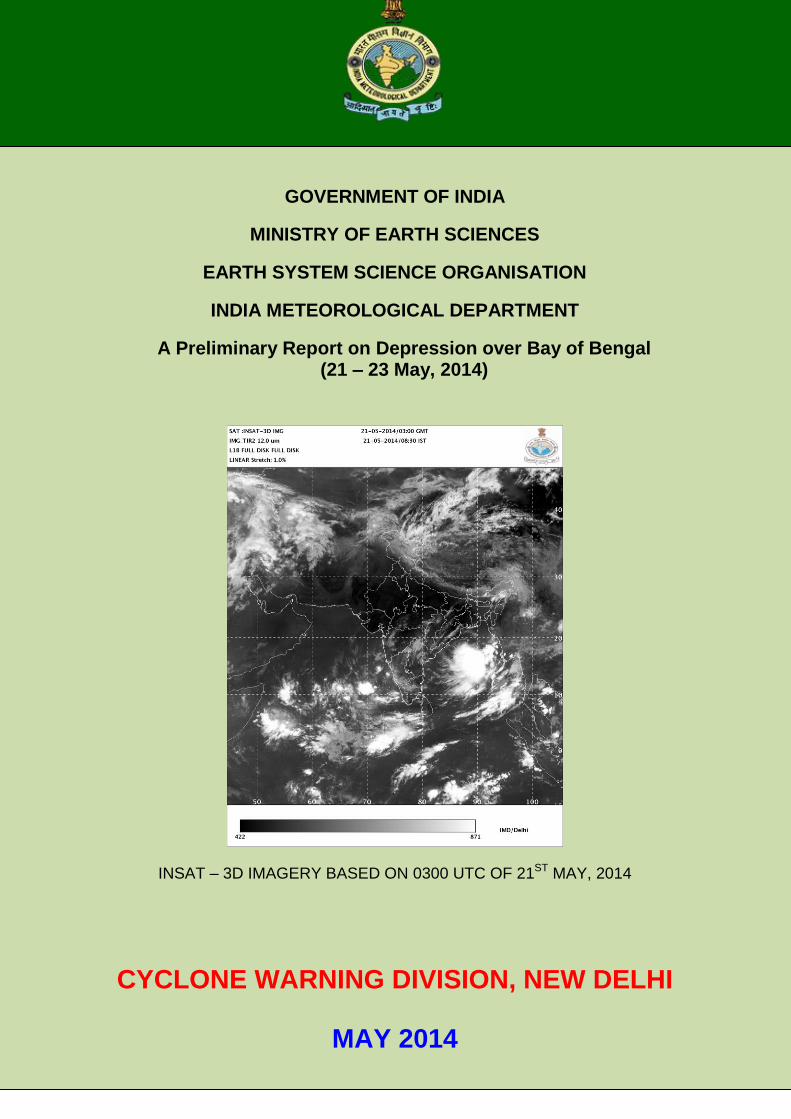
A Preliminary Report on Depression over Bay of Bengal (21 – 23 May, 2014)
INSAT – 3D IMAGERY BASED ON 0300 UTC OF 21ST MAY, 2014
CYCLONE WARNING DIVISION, NEW DELHI
MAY 2014
1
1. Introduction
A depression formed over eastcentral Bay of Bengal on 21st May 2014. It moved north
northeast wards initially and then southwestwards and weakened into a well marked low pressure
area over central Bay of Bengal in the morning of today, the 23rd May 2014. The salient features of
this depression is given below.
Though the depression weakened over the sea, it’s remnant low pressure area
moved across Odisha causing heavy rainfall over Odisha and adjoining areas.
The monitoring and prediction procedure along with the brief life cycle of the depression
and associated adverse weather, warnings issued by IMD and its verification are described
below.
2. Monitoring and prediction
The depression was mainly monitored by satellite. The half hourly INSAT 3D/Kalpana
imageries, and products, ASCAT surface winds and other internationally available satellite
products were used for monitoring of this depression. Various numerical weather prediction
(NWP) models and dynamical-statistical models including IMD’s global and meso-scale
models and models run at NCMRWF were utilized to predict the genesis, track and intensity
of the depression. Tropical Cyclone Module in the digitized forecasting system of IMD was
utilized for analysis and comparison of various observational and NWP models products and
decision making process.
3. Genesis
Under the influence of an active monsoon surge, an upper air cyclonic circulation
formed over north Andaman sea and neighbourhood extending upto 4.5 km above mean
sea level (amsl) on 17th May. It persisted over the same area and extended upto 5.8 km
(amsl) on 18th. Under its influence, a low pressure area formed over southeast and adjoining
eastcentral Bay of Bengal at 0300 UTC of 19th May 2014. It moved northwestwards and
became a well marked low at 0300 UTC of 20th May 2014. It concentrated into a depression
at 0300 UTC of 21st May 2014 over eastcentral Bay and lay centred near latitude 15.50 N
and longitude 90.50 E, about 490 km northnortheast of Port Blair. The ASCAT winds data
indicated cyclonic circulations with wind speed of 20-25 knots around the system centre. The
winds were stronger in the southern semicircle of the system in association with monsoon
surge. The low level convergence along with low level relative vorticity and upper level
divergence increased from 20th to 21st May 2014 favouring cyclogenesis. The sea surface
temperature was 30-320 C and ocean thermal energy was 60-80 kJ/cm2 around the system
centre. The vertical wind shear was moderate to high (15 – 30 knots). Satellite imageries
indicated intense to very intense convection with lowest cloud top temperature of about -750
C. The system had shear pattern as per the Dvorak’s intensity classification and the T
number was 1.5.
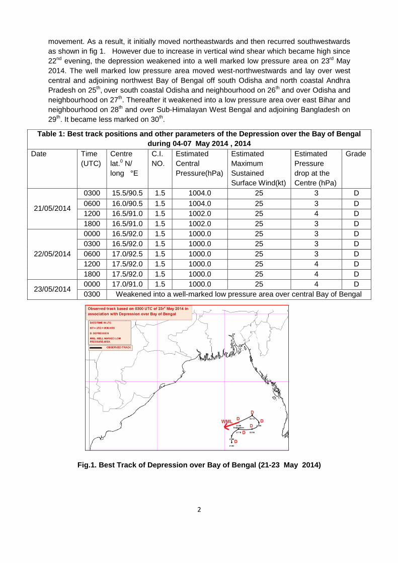
The best track parameters are shown in Table 1. The track of the system is shown in
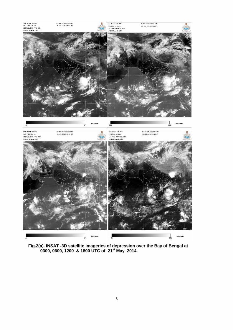
Fig.1. The typical satellite imageries of depression are shown in Fig.2. The IMD GFS model
analysis charts based on 0000 UTC during 21-27 May 2014 are shown in Fig.3.
4. Intensification and movement
The favourable conditions of lower level relative vorticity, lower level convergence,
upper level divergence, warmer SST (26-280 C) and associated convection persisted during
21st to 23rd May 2014. The system was mainly steered by the mid-tropospheric flow. As the
system lay close to the ridge in the middle level it could not follow any persistent direction of
2
movement. As a result, it initially moved northeastwards and then recurred southwestwards
as shown in fig 1. However due to increase in vertical wind shear which became high since
22nd evening, the depression weakened into a well marked low pressure area on 23rd May
2014. The well marked low pressure area moved west-northwestwards and lay over west
central and adjoining northwest Bay of Bengal off south Odisha and north coastal Andhra
Pradesh on 25th, over south coastal Odisha and neighbourhood on 26th and over Odisha and
neighbourhood on 27th. Thereafter it weakened into a low pressure area over east Bihar and
neighbourhood on 28th and over Sub-Himalayan West Bengal and adjoining Bangladesh on
29th. It became less marked on 30th.
Fig.1. Best Track of Depression over Bay of Bengal (21-23 May 2014)
Table 1: Best track positions and other parameters of the Depression over the Bay of Bengal
during 04-07 May 2014 , 2014
Date
Time
(UTC)
Centre
lat.0 N/
long °E
C.I.
NO.
Estimated
Central
Pressure(hPa)
Estimated
Maximum
Sustained
Surface Wind(kt)
Estimated
Pressure
drop at the
Centre (hPa)
Grade
21/05/2014
0300 15.5/90.5 1.5 1004.0 25 3 D
0600 16.0/90.5 1.5 1004.0 25 3 D
1200 16.5/91.0 1.5 1002.0 25 4 D
1800 16.5/91.0 1.5 1002.0 25 3 D
22/05/2014
0000 16.5/92.0 1.5 1000.0 25 3 D
0300 16.5/92.0 1.5 1000.0 25 3 D
0600 17.0/92.5 1.5 1000.0 25 3 D
1200 17.5/92.0 1.5 1000.0 25 4 D
1800 17.5/92.0 1.5 1000.0 25 4 D
23/05/2014 0000 17.0/91.0 1.5 1000.0 25 4 D
0300 Weakened into a well-marked low pressure area over central Bay of Bengal
3
Fig.2(a). INSAT -3D satellite imageries of depression over the Bay of Bengal at 0300, 0600, 1200 & 1800 UTC of 21st May 2014.

4
Fig.2(b). INSAT -3D satellite imageries of depression over the Bay of Bengal at 0000, 0300, 0600 & 1200 UTC of 22nd May 2014.
5
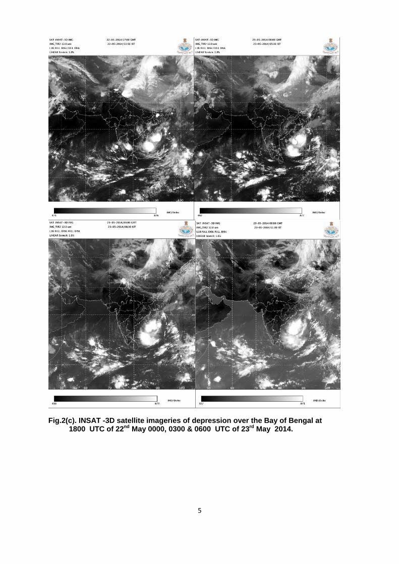
Fig.2(c). INSAT -3D satellite imageries of depression over the Bay of Bengal at 1800 UTC of 22nd May 0000, 0300 & 0600 UTC of 23rd May 2014.

6
Fig.2(d). INSAT -3D satellite imageries of depression over the Bay of Bengal at 0300 UTC of 24th – 27th May 2014.

7
Fig.3(a). IMD-GFS MSLP charts based on 0000z on 21st - 27th May 2014
8
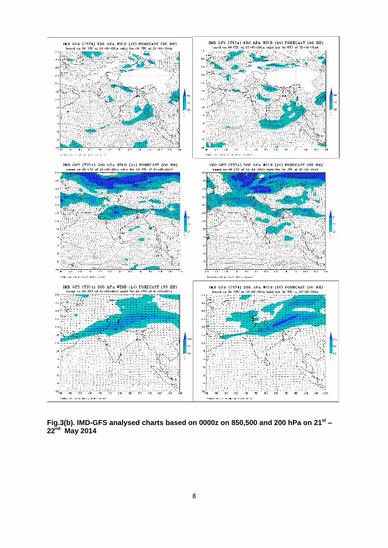
Fig.3(b). IMD-GFS analysed charts based on 0000z on 850,500 and 200 hPa on 21st – 22nd May 2014

9
Fig.3(c). IMD-GFS analysed charts based on 0000z on 850, 500 and200 hPa on 23rd – 24th May 2014
10
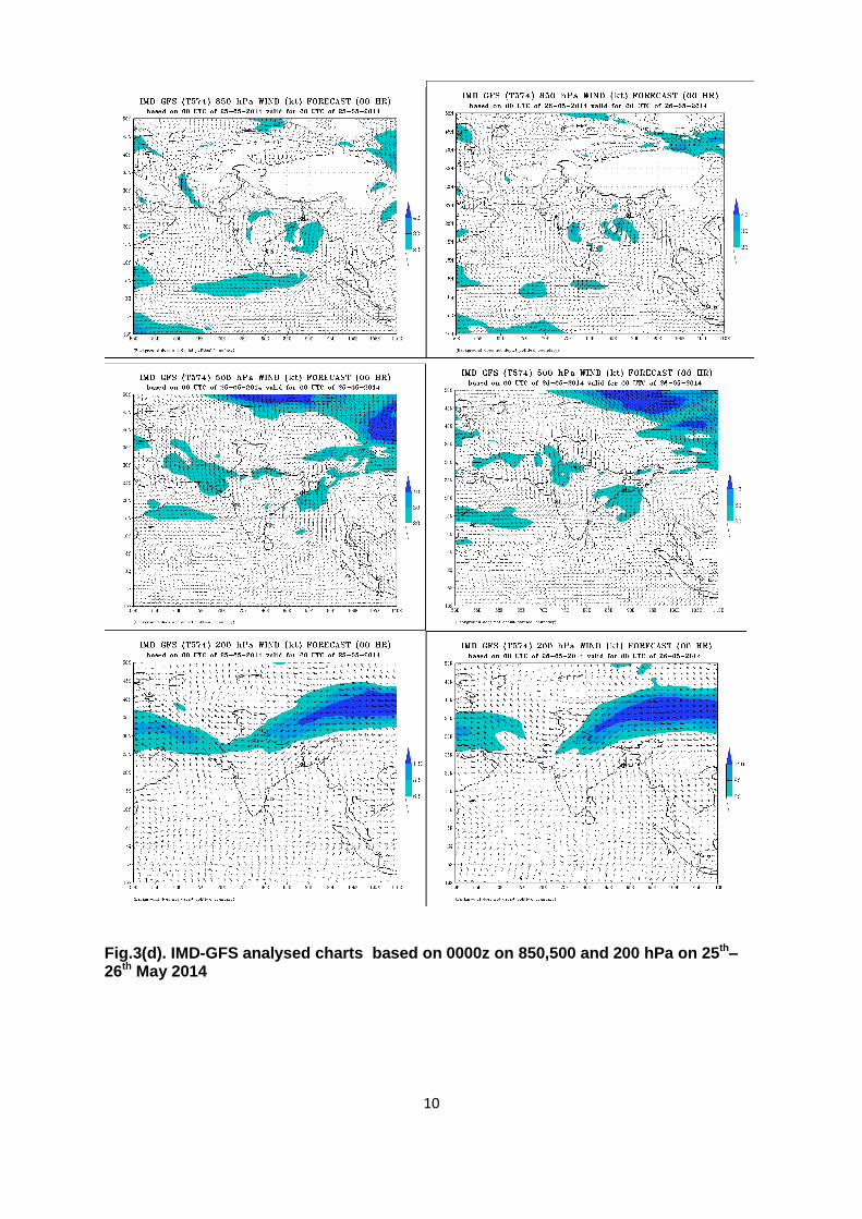
Fig.3(d). IMD-GFS analysed charts based on 0000z on 850,500 and 200 hPa on 25th– 26th May 2014

11
Fig.3(e). IMD-GFS analysed charts based on 0000z on 850, 500 and 200 hPa on 27th May 2014 5. Warning services
The Cyclone Warning Division / Regional Specialised Meteorological Centre
(RSMC)-Tropical Cyclone, IMD, New Delhi mobilised all its resources for monitoring and
prediction of Depression. It issued 3/6 hourly warning/advisory bulletins to national disaster
management agencies. It issued forecast and warning bulletins to various national and
international disaster management agencies including National Disaster Management
(NDM), Ministry of Home Affairs (MHA), concerned state Govts. and other users in regular
intervals. It also issued advisories to World Meteorological Organisation (WMO)/Economic
and Social Cooperation for Asia and the Pacific (ESCAP) Panel member countries including
Bangladesh, Myanmar, Thailand, Pakistan, Oman, Sri Lanka and Maldives during
depression period. The graphical display of the observed track was uploaded in the IMD's
website regularly. The number of bulletins issued by the Regional Specialised
Meteorological Centre and depression warning division, New Delhi, are given below:
Bulletins for India : 11
Special Tropical Weather Outlook and Tropical Cyclone Advisory
Bulletin to all WMO/ESCAP Panel countries : 5
12
In addition, special e-mails about the depression were also sent to all concerned
offices.
6. Realized Weather:
Chief amounts of 24 hrs. Rainfall (1 cm or more) ending at 0300 UTC from 22nd
May to 27th May 2014 are given below:
22 May 2014 ANDAMAN & NICOBAR ISLANDS: Nancowary-2, Hut Bay-1, Car Nicobar (IAF)-1, Long Island-1, Car Nicobar-1, 23 May 2014 ANDAMAN & NICOBAR ISLANDS: Hut Bay-3, Nancowary-1, Car Nicobar-1, Car Nicobar
(IAF)-1,
24 May 2014 ANDAMAN & NICOBAR ISLANDS:Car Nicobar(IAF) -5, Car Nicobar-3, Hut Bay-1,
25 May 2014 COASTAL ANDHRA PRADESH: Parvatipuram-3, Chodavaram-3, Anakapalli-3, Anakapalle(A)-3, Bobbili-2, Srungavarapukota-2, Tanuku-2, Itchapuram-2, Gajapathinagaram-2, Tuni-1, Yerragondapalem-1, Mandasa-1, Therlam-1, Tekkali-1, ODISHA: Akhuapada-4, Chandbali-3, Astaranga ARG-3, Alipingal-3, Ranpur-2, Nimpara-2, Puri-2, Cuttack-2, Gopalpur-2, Kendrapara-2, Paradeep Cwr-1, Derabis ARG-1, Bhubaneswar Aero-1, Marsaghai ARG-1, Balasore-1, Koraput-1, Jagatsinghpur AWS-1. ANDAMAN & NICOBAR ISLANDS: Hut Bay-3, Port Blair-3, IAF Car Nicobar (IAF)-2, Nancowary-2, Car Nicobar-2, Long Island-1, 26 May 2014 COASTAL ANDHRA PRADESH: Kalingapatnam-23, Tekkali-20, Pathapatnam-19, Palakonda-15, Veeragattam-11, Sompeta-11, Parvatipuram-10, Komarada-9, Palasa-9, Itchapuram-7, Bobbili-7, Cheepurupalli-7, Sathenapalli-6, Mandasa-6, Macharla-6, Salur-5, Ranasthalam-3, Rentachintala-3, Gajapathinagaram-3, Narsipatnam-3, Piduguralla-2, Therlam-2, Yellamanchili-2, Vijayanagaram-2, Bapatla-2, Bapatla(A)-2, Addanki-2, Kakinada-1, Araku Valley-1, Srungavarapukota-1, Chintapalli-1 TELANGANA: Miryalguda-8, Karimnagar-5, Nalgonda-4, Bhongir-4, Huzurabad-4, Kampasagar(A)-3, Ramannapet-3, Sultanabad-2, Jagtial-1, Jangaon-1, Asifabad-1, Suryapet-1, Ibrahimpatnam-1, Dubak-1, Chevella-1 ODISHA: Balasore-21, Gunupur-21, NH 5 Gobindpur-20, Paralakhemundi-20, Kashinagar-19, Pattamundai-19, Nuagada ARG-17, Soro-16, Mahendragarh-16, Tihidi ARG-16, Dhamnagar ARG-14, Bhubaneswar Aero-14, R.Udaigiri-14, Cuttack-14, Tirtol ARG-13, Basudevpur AWS-13, Niali ARG-13, Mahanga ARG-12, Khandapara-12, Bonth-12, Nilgiri-12, Kotraguda-12, Athgarh-12, Bissem-Cuttack-11, Muniguda ARG-11, Betanati ARG-11, Jagatsinghpur AWS-11, Raghunathpur ARG-11, Salepur ARG-11, Nischintakoili ARG-11, Bhadrak AWS-11, Bari ARG-10, Tikabali-10, Binjharpur ARG-9, Rayagada-9, Akhuapada-9, Banki ARG-9, Chandikhol ARG-9, Purushottampur-9, Balikuda ARG-9, Sorada-9, Derabis ARG-9, Gudari-9, Chandbali-8, Kendrapara-8, Bhograi-8, Mohana-8, Dhenkanal-8, Tigiria ARG-8, Tangi-8, Jenapur-8, Kashipur-8, Banarpal ARG-7, Jaipur-7, Balipatna ARG-7, Madhabarida-7, Anandpur-7, Thakurmunda-7, Gopalpur-7, Hindol-7, Jajpur-7, Bolagarh ARG-7, Balimundali-7, Danagadi ARG-7, Puri-7, Daringibadi-7, Marsaghai ARG-7, Aska-6, Rajkanika-6, Berhampur-6, Banpur-6, Rajghat-6, Kotagarh-6, Narsinghpur-6, Angul-6, Talcher-6, Kamakhyanagar-6, Parjang ARG-6, Nayagarh-5, Baripada-5, Belaguntha ARG-5,

13
Kantapada ARG-5, Bhuban ARG-5, Raikia ARG-5, Ranpur-5, Remuna ARG-5, Bhawanipatna-4, Daspalla-4, Narla ARG-4, Joshipur-4, Altuma CWC-4, Sukinda-4, Kaptipada ARG-4, Udala-4, Kankadahad ARG-4, Madanpur Rampur-4, Kujanga ARG-3, Odagaon ARG-3, Jaleswar-3, Similiguda AWS-3, Gania ARG-3, Jamsolaghat-3, Garadapur ARG-3, G Udayagiri AWS-3, Karanjia-3, Phiringia ARG-3, Koraput-3, Samakhunta AWS-3, Harabhanga-3, Bangiriposi-3, Kaniha ARG-3, Rairangpur-3, Tentulikhunti ARG-3, Ghatagaon-2, Swam-Patna-2, K Nuagaon ARG-2, Champua-2, Rajkishorenagar-2, Jeypore-2, Chendipada-2, Boudhgarh-2, Bargaon-2, Gurundia ARG-2, Athmalik-2, Phulbani-1, Tarva ARG-1, Paradeep -1, Pottangi-1, Loisingha ARG-1, Junagarh-1, Kesinga ARG-1, Binika-1, Keonjhargarh-1, Tiring-1, Dharmagarh ARG-1, Rairakhol-1, Baliguda-1, Bolangir-1, Reamal-1, Chandahandi ARG-1, Jhorigam ARG-1, Nawarangpur-1, Ullunda ARG-1 JHARKHAND: Balumath-6, Satgaon-3, Garhwa-2, Ghatsila-1 SUB–HIMALAYAN WEST BENGAL & SIKKIM: Bagrakote-9, Barobhisha-5, Mekhliganj ARG-5, Cooch Behar-3, Chepan-3, Jalpaiguri-2, Ravangla ARG-2, Sevoke-2, Rongo-1, Tadong-1, Dinhata ARG-1, Darjeeling-1, Alipurduar (CWC)-1, Gangtok-1, Domohani-1 GANGETIC WEST BENGAL: Contai-15, Digha-14, Sagar Island AWS-4, Bagati-4, Kharagpur (I.I.T)-3, Basirhat(PTO)-3, Kalaikunda (IAF)-2, Baruipur Agro-AWS-2, Diamond Harbour-2, Canning-2, Midnapore-2, Midnapore(CWC)-2, Mohanpur-1, Uluberia-1, Kolkata (Alipore)-1, Durgachack-1, Kalyani-1, D.P.Ghat-1. 27 May 2014 COASTAL ANDHRA PRADESH: Komarada-4, Parvatipuram-4, Veeragattam-1, Kalingapatnam-1 ODISHA: Kesinga ARG-28, Titlagarh-28, Bhawanipatna-26, Khariar-25, Komna-23, Junagarh-22, Patnagarh-19, Chandanpur-17, Paikmal-17, Padampur-16, Narla ARG-15, Balasore-15, Pattamundai-15, Ambabhona-14, Lanjigarh-14, Bolangir-13, NH 5 Gobindpur-13, Tarva ARG-13, Jharbandh ARG-13, Kantamal-11, Betanati ARG-10, Banki ARG-10, Kotraguda-10, Dharmagarh ARG-9, Jajpur-9, Muniguda ARG-9, Nilgiri-9, Tigiria ARG-9, Samakhunta AWS-8, Korei ARG-8, Tikabali-8, Bangiriposi-8, Rajkanika-8, Akhuapada-8, Remuna ARG-8, Rajghat-8, Madanpur Rampur-7, Udala-7, Gaisilet ARG-7, Bonth-7, Kaptipada ARG-7, Thakurmunda-7, Boden ARG-7, Dhamnagar ARG-7, Nawapara-7, Joshipur-7, Sinapali ARG-7, Tihidi ARG-7, Jaipur-7, Baripada-6, Bissem-Cuttack-6, Basudevpur AWS-6, Anandpur-6, Parjang ARG-6, Dunguripalli-6, Karanjia-6, Kashipur-6, Champua-6, Bargarh-6, Tirtol ARG-5, Derabis ARG-5, Garadapur ARG-5, Kendrapara-5, Pallahara-5, Talcher-5, Jaleswar-5, Danagadi ARG-5, Balimundali-5, Soro-5, Sohela-5, Bhadrak AWS-5, Swam-Patna-5, Sundargarh-5, Birmaharajpur ARG-5, Jenapur-5, Chandikhol ARG-5, Hemgiri-5, Daspalla-4, G Udayagiri AWS-4, Astaranga ARG-4, Chandbali-4, Barpalli ARG-4, Marsaghai ARG-4, Binika-4, Bargaon-4, Rajgangpur-4, Jamsolaghat-4, Kotagarh-4, Nischintakoili ARG-4, Binjharpur ARG-4, Bamra ARG-4, Bari ARG-4, Bhograi-4, Paradeep Cwr-4, Puri-3, Banarpal ARG-3, Kaniha ARG-3, Panposh-3, Ghatagaon-3, Krishnaprasad-3, Jharsuguda-3, Balikuda ARG-3, Raghunathpur ARG-3, Sukinda-3, Similiguda AWS-3, Mahanga ARG-3, Laikera-3, Tiring-3, Niali ARG-3, Gudari-3, Ullunda ARG-3, Kujanga ARG-3, Kuchinda-3, Gurundia ARG-3, Jujumura ARG-3, Harabhanga-3, Bijepur-3, Banpur-3, Rairangpur-3, Chandahandi ARG-3, Keonjhargarh-3, Dhenkanal-3, Kashinagar-3, Sonepur-2, Atabira ARG-2, Satyabadi ARG-2, Balisankara ARG-2, Daringibadi-2, Phiringia ARG-2, Phulbani-2, Gunupur-2, Jamankira-2, Bhubaneswar Aero-2, Ranpur-2, Batli ARG-2, Narsinghpur-2, Jagatsinghpur AWS-2, Telkoi-2, Rayagada-2, Jhumpura-2, Reamal-2, Bhuban ARG-2, Raikia ARG-2, Baliguda-2, Chendipada-2, Nayagarh-2, Jhorigam ARG-2, Altuma CWC-2, Kantapada ARG-2, Kamakhyanagar-2, Belaguntha ARG-2, Pipili-2, Hirakud-2, Nuagada ARG-2, Angul-2, Athmalik-2, Bolagarh ARG-2, Boudhgarh-1, Salepur ARG-1, Hindol-1, Nawarangpur-1, Sambalpur-1, Deogarh-1, Berhampur-1, Koraput-1, Pottangi-1, Gop-1, Banaigarh AWS-1, Cuttack-1, Athgarh-1, Kankadahad ARG-1, Jaipatna-1, K Nuagaon ARG-1, Balipatna ARG-1, Lahunipara-1, Purushottampur-1, Jeypore-1, Raighar ARG-1, Dabugan ARG-1, Umarkote-1, Rairakhol-1
14
JHARKHAND: Rajmahal-25, Dumri-11, Tenughat-10, Godda-10, Hiranpur-8, Ghatsila-7, Bokaro-7, Mohanpur-7, Giridih-6, Jarmindi-6, Barkisuriya-5, Hazaribagh-5, Ramgarh-5, Topchanchi-5, Kuru-5, Maheshpur-5, Tilaiya-5, Gomia-4, Madhupur-4, Hindgir-4, Chakradharpur-4, Hunterganj-4, Pathargama-4, Kurdege-4, Barhi-4, Jaridih-4, Sarath-4, Latehar-4, Satgaon-3, Moharo-3, Amrapara-3, Mehgawan-3, Kharsema-3, Maithon-3, Pakuria-2, Pakur-2, Torpa-2, Dhanbad-2, Chatra-2, Ranchi Aero-2, Pathalgada-2, Rajdhanwar-2, Simdega-2, Ormangi/Ormang-2, Tundi-2, Jamtara-2, Messenjore-2, Deoghar-1, Gobindpur-1, Jamshedpur-1, Daltonganj-1, Jamshedpur Aero-1, Panchet-1, Nandadih-1, Dumka-1, Putki-1 SUB–HIMALAYAN WEST BENGAL & SIKKIM: Ratua ARG-10, Malda-5, Chungthang-2, Gyalsing AWS-2, Ranipool-2, Sankalan-2, Gangtok-2, Soreng ARG-2, Damthang-2, Balurghat-1, Darjeeling-1, Tadong-1, Singla Bazar-1, Gajoldoba-1, Khanitar-1, Majitar-1, Kalimpong-1, GANGETIC WEST BENGAL: Durgachack-8, Kalaikunda (IAF)-5, Kolkata (Alipore)-5, Rampurhat-4, Berhampore-4, Diamond Harbour-4, Midnapore(CWC)-4, Midnapore-4, Sagar Island AWS-3, Tamluk AWS-3, Simula-3, Uluberia-3, Purulia-3, Tantloi-3, Kharidwar-3, Canning-3, Contai-2, Digha-2, Tusuma-2, Kansabati Dam-2, Kolkata (Dum Dum)-2, Bankura(CWC)-2, D.P.Ghat-2, Mohanpur-2, Basirhat(Pt)-2, Sri Niketan-2, Bankura-2, Suri (CWC)-1, Purihansa-1, Harinkhola-1, Tilpara Barrage-1, Gheropara-1, Burdwan (PTO)-1.
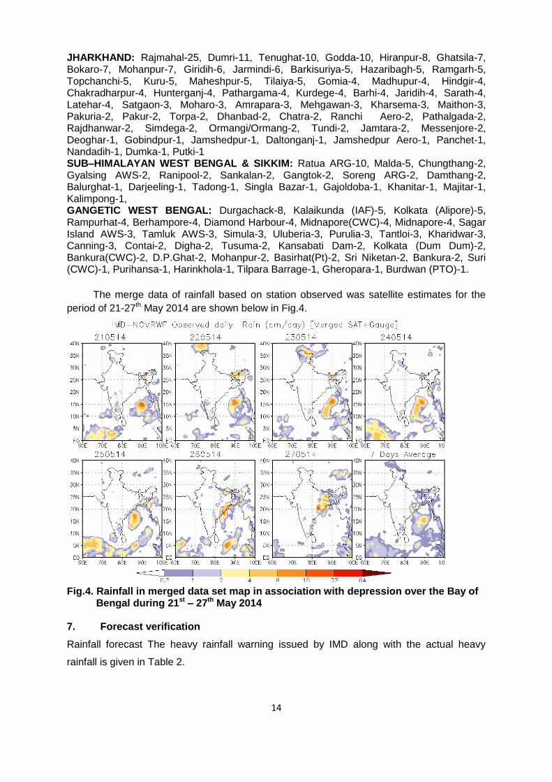
The merge data of rainfall based on station observed was satellite estimates for the
period of 21-27th May 2014 are shown below in Fig.4.
Fig.4. Rainfall in merged data set map in association with depression over the Bay of Bengal during 21st – 27th May 2014
7. Forecast verification
Rainfall forecast The heavy rainfall warning issued by IMD along with the actual heavy
rainfall is given in Table 2.
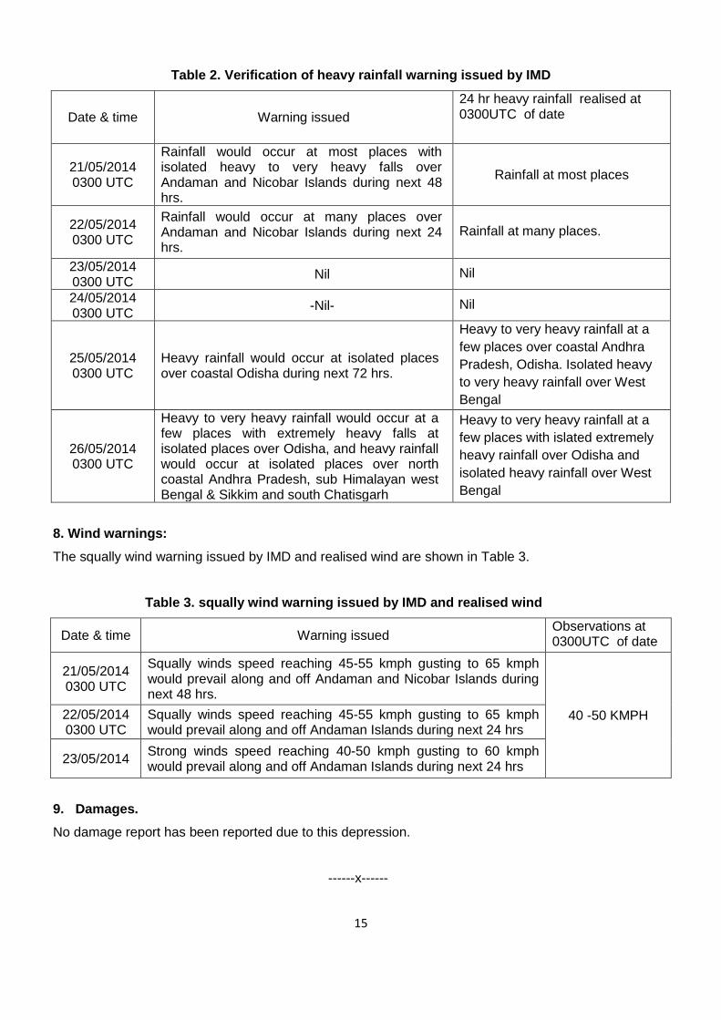
15
Table 2. Verification of heavy rainfall warning issued by IMD
Date & time Warning issued
24 hr heavy rainfall realised at 0300UTC of date
21/05/2014 0300 UTC
Rainfall would occur at most places with isolated heavy to very heavy falls over Andaman and Nicobar Islands during next 48 hrs.
Rainfall at most places
22/05/2014 0300 UTC
Rainfall would occur at many places over Andaman and Nicobar Islands during next 24 hrs.
Rainfall at many places.
23/05/2014 0300 UTC
Nil Nil
24/05/2014 0300 UTC
-Nil- Nil
25/05/2014 0300 UTC
Heavy rainfall would occur at isolated places over coastal Odisha during next 72 hrs.
Heavy to very heavy rainfall at a
few places over coastal Andhra
Pradesh, Odisha. Isolated heavy
to very heavy rainfall over West
Bengal
26/05/2014 0300 UTC
Heavy to very heavy rainfall would occur at a few places with extremely heavy falls at isolated places over Odisha, and heavy rainfall would occur at isolated places over north coastal Andhra Pradesh, sub Himalayan west Bengal & Sikkim and south Chatisgarh
Heavy to very heavy rainfall at a
few places with islated extremely
heavy rainfall over Odisha and
isolated heavy rainfall over West
Bengal
8. Wind warnings:
The squally wind warning issued by IMD and realised wind are shown in Table 3.
Table 3. squally wind warning issued by IMD and realised wind
Date & time Warning issued Observations at 0300UTC of date
21/05/2014 0300 UTC
Squally winds speed reaching 45-55 kmph gusting to 65 kmph would prevail along and off Andaman and Nicobar Islands during next 48 hrs.
40 -50 KMPH 22/05/2014 0300 UTC
Squally winds speed reaching 45-55 kmph gusting to 65 kmph would prevail along and off Andaman Islands during next 24 hrs
23/05/2014 Strong winds speed reaching 40-50 kmph gusting to 60 kmph would prevail along and off Andaman Islands during next 24 hrs
9. Damages.
No damage report has been reported due to this depression.
------x------