gold of afghanistan - mom.gov.af · gold of afghanistan figure 1. gold occurrences ... out on...
TRANSCRIPT

Gold of Afghanistan
Figure 1. Gold occurrences in Afghanistan on a low-resolution Landsat image, with areas of enhanced gold and mercury
potential (after Peters et al., 2007).
Gold in Afghanistan
Gold has been worked in Afghanistan from ancient times
and small-scale artisanal mining is still being carried
out on placer gold deposits in Takhar Province. The large
Samti and Nooraba placer deposits in Takhar have
recently been licensed and an Afghan company is
planning to extract 12 t of gold over the period of their
lease. There are a number of other prospects, which
have been evaluated by Soviet and Afghan teams in the
1970’s and there is a high probability that some of these
could be developed into working mines. Improved
exploration methods and modern metallogenetic
models, coupled with knowledge that Afghanistan lies
on a continuation of the Tethyan Metallogenic Belt,
have greatly improved the potential of the country.
Several areas of the country have potential for new
deposit types, such as fine-grained epithermal gold, not
sought by the Soviet-Afghan teams, and have been
largely unexplored.
The reports of the earlier Soviet exploration are now
available in Kabul. BGS and USGS have published
summaries of the geology and re-interpreted the earlier data
in the light of remote sensed information (Peters et al., 2007
and 2011).
Afghanistan has a complex geology due to its position on
the junction between the Indo-Pakistan and Eurasian crustal
plates. Its geology is composed of a series of terranes
that broke away from the main Gondwana Supercontinent
before colliding, with each other or, with the Eurasian Plate.
Ultimately, all the terranes became accreted onto the
southern margin of the Eurasian plate. The final closure of
the Neo-Tethys Ocean between the Indo-Pakistan and
Eurasian plates produced the Himalayan orogeny. During
this oblique collision NW-directed subduction occurred
beneath the Tirin-Argandab zone and a number of
calc-alkaline granite bodies were intruded, accompanied
by porphyry
copper-gold mineralisation of the Tethyan Metallogenic
Belt (TMB). Further north in Badakhshan there are a
number of prospects and occurrences of metamorphic
lode gold in areas of Hercynian and later Cimmerian
folding. This zone may extend southward into Parwan
as shown in Figure 1 and even further to the west
associated with folding related to the closure of
Palaeo-Tethys along the Herat terrane boundary.
Orogenic Gold Deposits
Potential for shear-zone vein-gold mineralisation exists
along the major trans-crustal structural breaks
representing remnant terrane collisional boundaries.
Gold potential also occurs within Phanerozoic rocks in
moderate to gently dipping fault/suture zones related to
continental margin collisional tectonism. Suture zones
characterised by ophiolitic remnants between diverse
assemblages of island arcs, subduction complexes and
continental margin clastic wedges are also prospective.
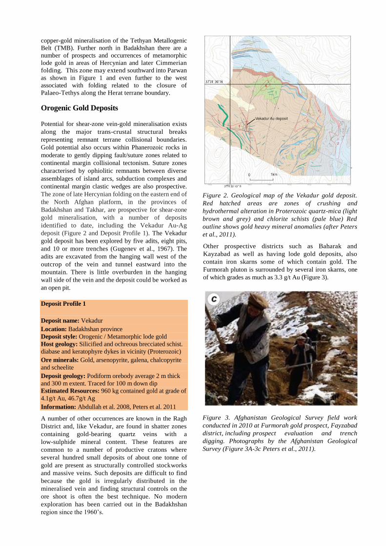
The zone of late Hercynian folding on the eastern end of
the North Afghan platform, in the provinces of
Badakhshan and Takhar, are prospective for shear-zone
gold mineralisation, with a number of deposits
identified to date, including the Vekadur Au-Ag
deposit (Figure 2 and Deposit Profile 1). The Vekadur
gold deposit has been explored by five adits, eight pits,
and 10 or more trenches (Gugenev et al., 1967). The
adits are excavated from the hanging wall west of the
outcrop of the vein and tunnel eastward into the
mountain. There is little overburden in the hanging
wall side of the vein and the deposit could be worked as
an open pit.
Deposit Profile 1
Deposit name: Vekadur
Location: Badakhshan province
Deposit style: Orogenic / Metamorphic lode gold
Host geology: Silicified and ochreous brecciated schist.
diabase and keratophyre dykes in vicinity (Proterozoic)
Ore minerals: Gold, arsenopyrite, galena, chalcopyrite
and scheelite
Deposit geology: Podiform orebody average 2 m thick
and 300 m extent. Traced for 100 m down dip
Estimated Resources: 960 kg contained gold at grade of
4.1g/t Au, 46.7g/t Ag
Information: Abdullah et al. 2008, Peters et al. 2011
A number of other occurrences are known in the Ragh
District and, like Vekadur, are found in shatter zones
containing gold-bearing quartz veins with a
low-sulphide mineral content. These features are
common to a number of productive cratons where
several hundred small deposits of about one tonne of
gold are present as structurally controlled stockworks
and massive veins. Such deposits are difficult to find
because the gold is irregularly distributed in the
mineralised vein and finding structural controls on the
ore shoot is often the best technique. No modern
exploration has been carried out in the Badakhshan
region since the 1960’s.
Figure 2. Geological map of the Vekadur gold deposit.
Red hatched areas are zones of crushing and
hydrothermal alteration in Proterozoic quartz-mica (light
brown and grey) and chlorite schists (pale blue) Red
outline shows gold heavy mineral anomalies (after Peters
et al., 2011).
Other prospective districts such as Baharak and
Kayzabad as well as having lode gold deposits, also
contain iron skarns some of which contain gold. The
Furmorah pluton is surrounded by several iron skarns, one
of which grades as much as 3.3 g/t Au (Figure 3).
Figure 3. Afghanistan Geological Survey field work
conducted in 2010 at Furmorah gold prospect, Fayzabad
district, including prospect evaluation and trench
digging. Photographs by the Afghanistan Geological
Survey (Figure 3A-3c Peters et al., 2011).

Placer Gold Small-scale placer gold mining appears to have been
conducted in the streams and rivers of the Hindu Kush
for many centuries and continues locally today in both
placers and paleoplacers in Takhar Province. Reports
persist of local people putting sheepskins in mountain
streams in Badakhshan Province to serve as fleece
sluices capable of catching fine gold, reminiscent of
tales of the 'Golden Fleece'.
Soviet and Afghan geologists undertook the first
industrial-scale exploration for placer gold and made
some major discoveries (Galchenko et al., 1972),
notably Samti, Nuruba, Chah-i-Ab and Jar Bolshi and
a large number of smaller occurrences (Figure 4).
The Soviets withdrew from Afghanistan and they did
not mine any placer gold, although they left behind
copies of their meticulous drilling records, and these
are preserved in the extensive Geological Archives of
the Afghanistan Geological Survey.
It is clear the grades and extent of the placer gold has
been underestimated by the Soviet geologists due to
due to limitations in the Soviet exploration methods:
Firstly, it is apparent the Soviet-driven exploration effort
was limited to areas with good water supplies in order to
facilitate wet washing of the placer ores by wash-plants
such as PgSh sluices that require water cannons.
Accordingly less than 10% of Afghanistan was explored
for placer gold. Indeed no evidence has been found of
drywashers having been used for prospecting for placer
gold in Afghanistan. This is being remedied in 2014 with
the introduction of USA drywashers by the USAID
MIDAS project, and making by the Ministry of small
recirculating sluices based on a USA design that requires
minimal water.
Secondly, the Soviet drillers used numerous placer
drilling rigs of a single type - Soviet churn drills - that
while being the respected industry standard for terraces
and dryish floodplains are known to systematically lose
most of the gold when used in waterlogged ground such
as wet floodplains. This fact has been known for many
decades in the Russian placer gold industry. The AGS
Khair Khana Engineering Works contains more than 30
old churn drills that Soviet Reports and photos show
were used intensively in exploring for placers in northern
Afghanistan, particularly Takhar Province. Samti Gold Dredge Resource
An outstanding success was the systematic proving of
a resource of 30 tonnes of placer gold by churn
drilling on the active floodplain of the Amu Darya
near the village of Samti in Takhar Province. This led
to the Ministry of Mines and Petroleum issuing a
10-year exploitation and development contract for the
Samti and Nooraba deposits with the Afghan
company, West Land Trading Company (WLT)
(MoMP 2010). The contract was based on extraction
of 12 tonnes of gold from the waterlogged Samti
deposit and a further 580 kilos from the dryer
Nooraba deposit. Systematic GIS recalculation of the
drilling results of the Samti deposit by the United
States Geological Survey confirms the manual Soviet
estimated resource of 30 tonnes, which is large by
current world standards. Nevertheless it is believed to
be a substantial underestimate of the true magnitude
of the Samti gold resource.
The heavy gold losses of Soviet churn drills was
familiar to Soviet placer geologists, and indeed the
remains of an unused Soviet bucket drill has been
identified at the AGS Khair Khana Engineering
Warehouse. A Soviet-Canadian data set of more than
1,000 boreholes in Mongolia proved the gold
recovery of Soviet bucket drills to be close to 100%,
while Soviet churn drills usually lost more than 65%
of the gold in the same wet ground (Grayson 2014).
Applying the correction factor to the Samti churn
drilling indicates that the actual gold resource is likely
to be in the region of 100 tonnes, with an
in-the-ground value of about 4 billion USD, which
would rank Samti among the largest gold dredge
projects in the world.
A limited programme of repeat drilling by a Russian
bucket drill would suffice to confirm the appropriate
correction factor to be applied to the gold grade, so
enabling the resource envelope to be identified and the
dredge envelope to be calculated. The appropriate
method of mining would be a civil engineering
cutter-suction dredge pumping the overburden away to
raise flat land several kilometres away so creating a large
dredge pond to hold a large mineral dredge such as a
Russian, Dutch or USA bucket-line dredge with on-board
wash-plant to recover the gold. Accordingly a modified
German Ruhr grab dredge may be an attractive
alternative, having a reach of more than twice the depth
of the placer gold. Finally a large civil cutter suction
dredge might be considered, having the merit of wide
availability and lower cost, albeit at some peril of losing
some gold.
Figure 5. Placer gold deposit consisting of alluvial sand
and conglomerate of the Panj River.
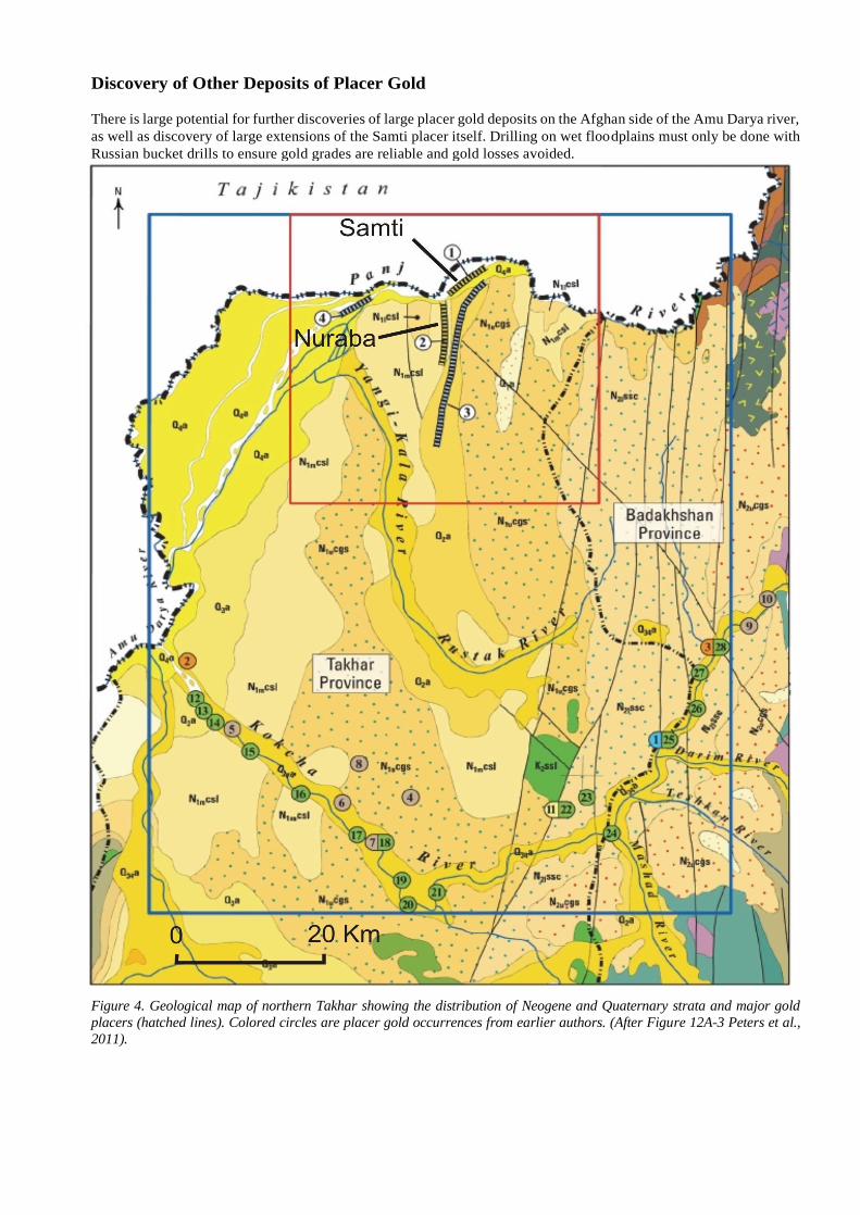
Discovery of Other Deposits of Placer Gold There is large potential for further discoveries of large placer gold deposits on the Afghan side of the Amu Darya river,
as well as discovery of large extensions of the Samti placer itself. Drilling on wet floodplains must only be done with
Russian bucket drills to ensure gold grades are reliable and gold losses avoided.
Figure 4. Geological map of northern Takhar showing the distribution of Neogene and Quaternary strata and major gold
placers (hatched lines). Colored circles are placer gold occurrences from earlier authors. (After Figure 12A-3 Peters et al.,
2011).
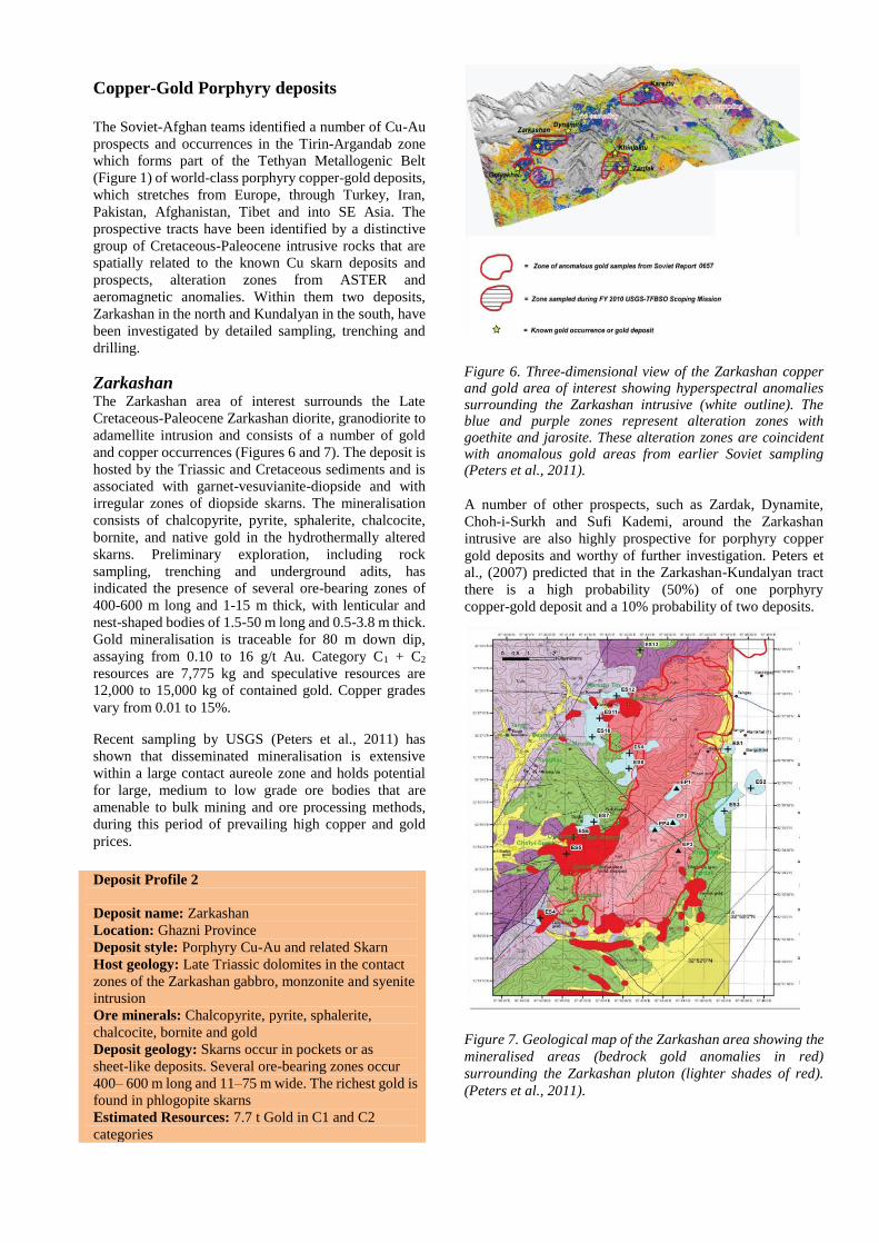
Copper-Gold Porphyry deposits The Soviet-Afghan teams identified a number of Cu-Au
prospects and occurrences in the Tirin-Argandab zone
which forms part of the Tethyan Metallogenic Belt
(Figure 1) of world-class porphyry copper-gold deposits,
which stretches from Europe, through Turkey, Iran,
Pakistan, Afghanistan, Tibet and into SE Asia. The
prospective tracts have been identified by a distinctive
group of Cretaceous-Paleocene intrusive rocks that are
spatially related to the known Cu skarn deposits and
prospects, alteration zones from ASTER and
aeromagnetic anomalies. Within them two deposits,
Zarkashan in the north and Kundalyan in the south, have
been investigated by detailed sampling, trenching and
drilling.
Zarkashan The Zarkashan area of interest surrounds the Late
Cretaceous-Paleocene Zarkashan diorite, granodiorite to
adamellite intrusion and consists of a number of gold
and copper occurrences (Figures 6 and 7). The deposit is
hosted by the Triassic and Cretaceous sediments and is
associated with garnet-vesuvianite-diopside and with
irregular zones of diopside skarns. The mineralisation
consists of chalcopyrite, pyrite, sphalerite, chalcocite,
bornite, and native gold in the hydrothermally altered
skarns. Preliminary exploration, including rock
sampling, trenching and underground adits, has
indicated the presence of several ore-bearing zones of
400-600 m long and 1-15 m thick, with lenticular and
nest-shaped bodies of 1.5-50 m long and 0.5-3.8 m thick.
Gold mineralisation is traceable for 80 m down dip,
assaying from 0.10 to 16 g/t Au. Category C1 + C2
resources are 7,775 kg and speculative resources are
12,000 to 15,000 kg of contained gold. Copper grades
vary from 0.01 to 15%.
Recent sampling by USGS (Peters et al., 2011) has
shown that disseminated mineralisation is extensive
within a large contact aureole zone and holds potential
for large, medium to low grade ore bodies that are
amenable to bulk mining and ore processing methods,
during this period of prevailing high copper and gold
prices.
Deposit Profile 2
Deposit name: Zarkashan
Location: Ghazni Province
Deposit style: Porphyry Cu-Au and related Skarn
Host geology: Late Triassic dolomites in the contact
zones of the Zarkashan gabbro, monzonite and syenite
intrusion
Ore minerals: Chalcopyrite, pyrite, sphalerite,
chalcocite, bornite and gold
Deposit geology: Skarns occur in pockets or as
sheet-like deposits. Several ore-bearing zones occur
400– 600 m long and 11–75 m wide. The richest gold is
found in phlogopite skarns
Estimated Resources: 7.7 t Gold in C1 and C2
categories
Figure 6. Three-dimensional view of the Zarkashan copper and gold area of interest showing hyperspectral anomalies surrounding the Zarkashan intrusive (white outline). The blue and purple zones represent alteration zones with goethite and jarosite. These alteration zones are coincident with anomalous gold areas from earlier Soviet sampling (Peters et al., 2011). A number of other prospects, such as Zardak, Dynamite,
Choh-i-Surkh and Sufi Kademi, around the Zarkashan
intrusive are also highly prospective for porphyry copper
gold deposits and worthy of further investigation. Peters et
al., (2007) predicted that in the Zarkashan-Kundalyan tract
there is a high probability (50%) of one porphyry
copper-gold deposit and a 10% probability of two deposits.
Figure 7. Geological map of the Zarkashan area showing the
mineralised areas (bedrock gold anomalies in red)
surrounding the Zarkashan pluton (lighter shades of red).
(Peters et al., 2011).

Kundalyan The Kundalyan copper - gold skarn deposit is localized
along a 400-metre long, 1.5 km wide wide inlier that
consists of altered limestone, chert, and skarn (Peters et
al., 2011 after Soviet authors). The chief minerals in
the skarn are pyroxene, garnet, amphibole,
phlogopite, and magnetite. Mineralisation is present
both in skarn and chert. There are 13 ore bodies along the
Kundalyan Fault Zone (Figure 8A) that are from 2.65 to
12.3 m thick and from 36 to 175 m long, containing
0.62-1.2% Cu and 0.5-2.0 g/t Au. The mineralisation is
predominately chalcopyrite and pyrite and more seldom
sphalerite, gray copper ore, and enargite. The Category
C1+C2 reserves in the Soviet classification system, are
13,600 t of contained copper and 1.1 t gold at grades of
1.07% Cu and 0.9 g/t Au.
The Kundalyan copper-gold skarn deposit area was
explored by a series of trenches, adits, and drill holes.
Data were presented on cross sections (Figure 8B) for
about 5 km of strike length along a NNW-trending zone
that is exposed in a valley. The Kundalyan copper -gold
deposit has been explored where a northwest-striking
stream has eroded through colluvial cover and exposed
a granodioritic intrusive intruding Precambrian,
Cambrian, and Carboniferous limestone. The skarn zone
contains brecciated, stromatolitic(?) limestone and
contains large areas of layered calc-silicate rock related
to skarn formation and metasomatic kaolin-carbonate
rock. Malachite-stained siliceous skarn and
porphyroblastic marble also are common in the
mineralised zone. Despite the extensive trenching and the
boreholes in the main zone there seems to have been little
exploration of colluvium covered areas to west and east.
Several copper and copper-gold and gold prospects and
occurrences are present peripheral to or away from the
main Kundalyan copper-gold skarn deposit. Prospects
generally cluster near and around the Kundalyan group
of deposits in these areas: Kaptarghor,
Shela-i-Surkh, Baghawan-Garangh, Kunar and
Chasu-Ghumbad. Further details can be found in Peters et
al., (2011).
Deposit Profile 3
Deposit name: Kundalyan
Location: Zabul province
Deposit style: Cu-Mo-Au-Ag skarn
Host geology: Proterozoic and Vendian-Cambrian
metamorphosed limestones and cherts
Ore minerals: Chalcopyrite, magnetite, pyrite,
sphalerite, molybdenite, chalcocite, bornite, covellite,
native Cu, malachite
Deposit geology: Three deposits up to 155 m long and
2.59-3.89 m thick. Mineralisation restricted to
hematite-kaolin-quartz and meta-carbonates
Estimated Resource: C1+C2 resources 13600t
contained copper Cu @ 1.07% Cu; 1.1t contained gold
Au @ 0.9 g/t Au; 127.3t contained Mo @ 0.13% Mo
Figure 8. (A) Geological map of the Kundalyan area showing
the ore zone (black), skarn (orange), kaolin- carbonate rock
(grey), altered granitoids (pale blue), granodiorite (green)
and colluvium (pale yellow). (B) Illustrative cross section
through boreholes 2 and 7 at Kundalyan (key as above).
A
B

Epithermal Gold Hot-spring epithermal gold deposits have not been positively identified but there are indications that they may be present in the epithermal mercury zone of central Afghanistan and Katawaz basin (Figure 1). In central Afghanistan in the Kharnak-Kanjar area, (Figure 9) disseminations and veinlets of cinnabar accompanied by carbonate, dickite and silica alteration and lesser pyrite, chalcopyrite and arsenic minerals are found in early Cretaceous calcareous rocks intruded by Eocene to Oligocene porphyry diorite dykes and volcanics. The features indicate the presence of a very large low-temperature hydrothermal system. Elsewhere in the world such systems host significant gold resources and are the focus of major exploration investment (Peters et al., 2007, 2011). In the Katawaz basin Abdullah et al. (2008) observed telethermal (epithermal) lead, zinc, mercury and gold mineralisation belonging to the orogenic (Miocene) stage of the basin's evolution.
Geological map of the Kharnak-Kanjar Area showing the location of the mercury mineralisation (red symbols). Cretaceous rocks in green shades, (Geology from Peters et al., 2007).
Sources of Information Abdullah S.H., et al. (2008) Geology and Mineral Resources of Afghanistan. 2 volumes. English Version, Republished in 2008 by British Geological Survey Occasional Publication No.15. 2 volumes. British Geological Survey (2008): Geological archive of Afghanistan. AGSMiscellaneous Report. 360 pages.
Galchenko, I.I. (1975): Report by the Nuraba party on the results of detailed exploration of the Samty placer gold with the reserves estimation: Department of Geological and Mineral Su rvey, AGS Archive, Kabul.
Galchenko I.I., Zakandyrin V.V., and Vaseckiy, F.N. (1972): The Samti placer gold deposit - Report of the Nurabin prospecting-explorational group on the works of 1970-72, aimed at preliminary exploration of placer gold deposit of Samti with estimation of reserves as at 1 June 1972), AGS Archive, Kabul.
Grayson, Robin (2014): The Gold Miners Book - BAT - Best Available Techniques for Placer Gold Miners. Afghan edition USAID-MIDAS, 1,851 pages, 2,605 photos, 830 drawings, 6,556 references.
Gugenev, M.P., Smirnov M.S., Skipin G.G. (1967): report on prospecting and exploration for gold occurrences in Badakshan province in 1966. V. I-II: Kabul, Department of Geological and Mineral Survey,
Orris, G.J., and Bliss, J.D. (2002): Mines and Mineral Occurrences of Afghanistan, USGS Open-File Report 02-110. http://geopubs.wr.usgs.gov/open -file/of02-110/
Peters, S.G. Lugington, S.D., Orris, G.J., Sutphin, D.M., and Bliss, J.D., eds. (2007): Preliminary Non-Fuel Mineral Resource Assessment of Afghanistan: USGS Open-File Report 2007-1214.
Peters, S.G., King, T.V.V., Mack, T.J., Chornack, M.P., eds., and the USGS Afghanistan Mineral Assessment Team (2011): Summaries of important areas for mineral investment and production opportunities of nonfuel minerals in Afghanistan: USGS Open-File Report 2011-1204, 1,810 pages plus appendixes on DVD. http://pubs.usgs.gov/of/2011/1204/
Government Strategy on Mineral Resource Development
The GoA has recognized the country’s mineral resources
as valuable assets that can be developed to create
employment and promote economic independence.
Under this goal, the GoA has recently made significant
policy changes following its transition from state
operator to regulator and is now driving infrastructural
development with a view to enhancing and promoting Mineral resource development. The GoA is constantly seeking investment from the private and foreign investors to develop the huge and very diverse mineral resource potential of Afghanistan.
Further Information:
For further information on technical and investment matters, please contact the following offices within the Ministry of Mines and Petroleum: Mineral Sector Development Directorate
Ministry of Mines and Petroleum
Kabul, Afghanistan
Telephone: +93 (0) 752 076 483
E-Mail: [email protected]
Website: http://www.mom.gov.af
Afghanistan Geological Survey
Kabul, Afghanistan
Tel: +93 (0) 75 200 1714
E-mail: [email protected]
©Afghanistan Geological Survey
updated January 16, 2014 by MoMP with assistance of USAID MIDAS project