goes-r risk reduction annual meeting 2011 christian kummerow cira director 22 september 2011 1
Post on 21-Dec-2015
219 views
TRANSCRIPT

1
GOES-R Risk Reduction Annual Meeting 2011
Christian KummerowCIRA Director22 September 2011

2
CIRA Product Development Interest
• Tropical cyclone genesis
• Severe weather forecasting
• Data Assimilation for maximum data use
• Solar energy forecasts
• Data fusion for cloud properties
• Precipitation, orographically forced precipitation
• Snow & snow melt

3
Risk Reduction Research
GOES Improved Measurements and Product Assurance
Plan (GIMPAP)
Product System Development and Implementation (PSDI) Program
Algorithm Working Groups
Proving Ground Testbed
Operational SatellitesFuture Satellites/SensorsTime line
Year 4-5
Year 6-7
Fundamental Research
Year 1-3
Product Implementation Program
WFO Boulder Forecaster Chad Gimmestad Studying GeoColor
WRF-based Synthetic ABI 10.35µm Imagery (02/27/2011)
TC Dora (2011) ABI Natural ColorImagery
4
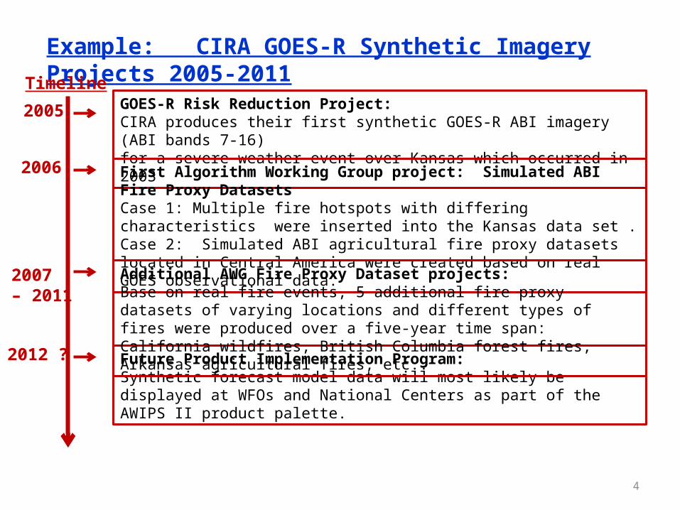
GOES-R Risk Reduction Project:CIRA produces their first synthetic GOES-R ABI imagery (ABI bands 7-16)for a severe weather event over Kansas which occurred in 2003
First Algorithm Working Group project: Simulated ABI Fire Proxy DatasetsCase 1: Multiple fire hotspots with differing characteristics were inserted into the Kansas data set . Case 2: Simulated ABI agricultural fire proxy datasets located in Central America were created based on real GOES observational data.
Example: CIRA GOES-R Synthetic Imagery Projects 2005-2011
Timeline
2006
2007 – 2011
2005
Future Product Implementation Program: Synthetic forecast model data will most likely be displayed at WFOs and National Centers as part of the AWIPS II product palette.
Additional AWG Fire Proxy Dataset projects: Base on real fire events, 5 additional fire proxy datasets of varying locations and different types of fires were produced over a five-year time span: California wildfires, British Columbia forest fires, Arkansas agricultural fires, etc..
2012 ?

5
GOES-R Risk Reduction Project:CIRA produces their first synthetic GOES-R ABI imagery (ABI bands 7-16)for a severe weather event over Kansas which occurred in 2003
First Algorithm Working Group project: Simulated ABI Fire Proxy DatasetsCase 1: Multiple fire hotspots with differing characteristics were inserted into the Kansas data set . Case 2: Simulated ABI agricultural fire proxy datasets located in Central America were created based on real GOES observational data.
5-year CIRA GOES-R Synthetic Imagery Project
Timeline
2005 - 2011
Future Product Implementation Program: Synthetic forecast model data will most likely be displayed at WFOs and National Centers as part of the AWIPS II product palette.
Additional AWG Fire Proxy Dataset projects: Base on real fire events, 5 additional fire proxy datasets of varying locations and different types of fires were produced over a five-year time span: California wildfires, British Columbia forest fires, Arkansas agricultural fires, etc..
2012 ?
Risk reduction research on simulated GOES-R ABI datasets
including the production of simulated ABI datasets for different
type of weather and fire events.

6
Collaborative Computing Environment (CCE)
Oper. Product R&D(Alg. Working Groups)
Exp. Product R&D(Risk Reduction)
Proving Grounds & Testbeds
Satellite Algorithm Test Bed (SATB)
Satellite Operational Algorithm Readiness (SOAR)
A paradigm for multi-sensor fusion product development
Common environment for rapid R2O transition
R&D Coupled to End-User Needs
Evolution of STAR
SOAR must ‘fly above’ any single satellite program and provide an environment for integrated product development.

7
Thematic Approach (Example)
Solar Energy Forecasting
NOAA Models Satellite Resources Partners
GOES Satellite Program
GIMPAP
Solar Energy Forecasting HRRR, LAPS, GFS, etc. GOES, GOES-R, JPSS,International
NREL, Industry
A big-picture approach provides broader connection between NOAA resources, provides latitude to define research approach optimally, and ties research to end-user throughout the development process.
GOES Product
Ongoing program, sustained student involvement1-2 year project
Satellite/Model Fusion Products
NSOF Operations Operational Transitions to Vested Users
Stovepipe Linear Model Parallel Model