goes-r awg 2 nd validation workshop hye-yun kim (imsg), istvan laszlo (noaa) and hongqing liu (imsg)...
TRANSCRIPT

Shortwave Radiation Budget (SRB) Algorithm and Products
GOES-R AWG 2nd Validation Workshop
Hye-Yun Kim (IMSG), Istvan Laszlo (NOAA) and Hongqing Liu (IMSG)
GOES-R AWG 2nd Validation Workshop, Jan 9 - 10, 2014

2
Outline
Algorithm, products and proxy data overview
Evaluation procedure Recent validation results Algorithm enhancements Post-launch test/product validation
and challenges Summary
GOES-R AWG 2nd Validation Workshop, Jan 9 - 10, 2014

3
SRB algorithm and products
SRB algorithm is a RT-based, hybrid algorithm Direct path: used when all inputs required are available. Indirect path: used when not all inputs are available.
Products Downward Shortwave Radiation at surface (DSR)
▪ 5 km (mesoscale), 25 km (CONUS), 50 km (Full Disk).
Reflected Shortwave Radiation at Top-Of-Atmosphere (RSR) ▪ 25 km (CONUS and Full Disk).
Generated every hour Only daytime Regardless of sky condition (clear, cloudy)
GOES-R AWG 2nd Validation Workshop, Jan 9 - 10, 2014

4
CERES TOA flux Proxy data generated
“ABI-like” DSR and RSR DSR and RSR for 8 sites for period 2000/2002-2013 RSR over extended area on specific dates
DSR in GOES Surface and Insolation Product (GSIP) (early version of ABI indirect path)
Proxy data
Proxy data used MODIS Terra/Aqua (added 3+ years of data since 1st Validation
Workshop); Period covered: 2000/2002-2013
▪ TOA reflectance (from MOD/MYD02),
▪ Geometry (from MOD/MYD03), ▪ Surface elevation (from
MOD/MYD03), ▪ Aerosol optical depth (from
MOD/MYD04), ▪ Cloud optical
depth/size/height/phase (from MOD/MYD06),
▪ Ozone (from MOD/MYD07), ▪ Total precipitable water (from
MOD/MYD07, NCEP Reanalysis), ▪ Snow mask (from MOD/MYD10), ▪ Surface albedo (from MCD43C3)
GOES-R AWG 2nd Validation Workshop, Jan 9 - 10, 2014

5
Validation (Reference) Data
SURFRAD+COVE for DSR, CERES for RSR
Field measurements at Cape Cod, MA (for deep dive) Location: 42.03°N, 70.05°W, near the ocean Part of the Two-Column Aerosol Project (TCAP) (ARM field campaign) Surface albedo and AOD measurements (partially supported by
GOES-R Proving Ground to Joseph Michalsky and Kathy Lantz (NOAA/ESRL))▪ Instruments: MFRSR and MFR (sampled every 20 seconds
simultaneously)▪ Deployment period: 28 June to 6 September, 2012 ▪ Wavelengths: 413, 496, 671, 869, 937, 1623 nm▪ Estimated uncertainty: is 0.01 in AOD, 2% in albedo
Surface radiation measurement▪ Instruments: Sky Radiation (SKYRAD) collection of radiometers
(1-minute sampling) for downwelling shortwave fluxes
GOES-R AWG 2nd Validation Workshop, Jan 9 - 10, 2014

6
Validation (1) : Collocation
Collocation process for product evaluation DSR: over ground station (SURFRAD+COVE)
▪ Collocation of retrieval and ground measurement is performed at instantaneous time scale.
▪ Retrievals are averaged spatially, ground measurements are averaged temporally.
RSR▪ Collocation of retrievals and independent satellite data.
“Monthly” instantaneous, all stations
new
GOES-R AWG 2nd Validation Workshop, Jan 9 - 10, 2014

7
Validation (2) : Routine validation
Routine and automated monitoring of products. Presents instantaneous retrieval results (DSR and RSR),
quality flags, and metadata on specific date. Validates retrievals for a period of time and generates
scatter plots and time series plots. Validates RSR over extended area using CERES on specific
date. Figures: DSR, DSR time series, RSR scatter, RSR and CERES
difference.
GOES-R AWG 2nd Validation Workshop, Jan 9 - 10, 2014

8
Validation (3) : Routine validation
Product monitoring Establish “reference” (expected) statistics from good (quality
controlled) satellite-retrievals and ground/TOA reference data Compare time series of recent retrieval statistics with reference
stats
Reference statistics Reference data: 13 years (2000/2002 – 2012) of ABI proxy retrievals
(from MODIS Terra/Aqua), SURFRAD+ ground DSR, CERES-based RSR Accuracy and precision are calculated from the reference data for
daily and monthly temporal scales (and at each station in the future)
Recent retrieval statistics Recent retrievals: MODIS Terra/Aqua (Jan. to Apr. 2013) Accuracy and precision are calculated from recent retrievals on
matching temporal and spatial scales
GOES-R AWG 2nd Validation Workshop, Jan 9 - 10, 2014

9
Validation (4) : Routine validation
DSR Range
Accuracy
Precision
<200 41 (110) 80 (100)
≥200,≤500 15 (65) 126 (130)
>500 -33 (85) 95 (100)
RSR Range
Accuracy
Precision
<200 12 (110) 28 (100)
≥200,≤500 16 (65) 46 (130)
>500 43 (85) 50 (100)GOES-R AWG 2nd Validation Workshop, Jan 9 - 10, 2014
(Requirements are in parenthesis)

10
Validation (5) : Routine validation
Comparison of reference and recent daily statistics.
Red, blue, green envelopes are reference stats. mean ± 1*std, mean ± 2*std,
mean ± 3*std
Recent retrievals in Jan. 2013 Downward SW radiation at surface
(DSR, top) Reflected SW radiation at TOA (RSR,
bottom)
Recent retrieval statistics mostly fall within ± 2*std range of reference statistics.
GOES-R AWG 2nd Validation Workshop, Jan 9 - 10, 2014

11
Validation (6) : Routine validation
Example of DSR daily validation GOES-R validation tool
is applied to operational GOES Surface and Insolation Product (GSIP)
Ground DSR (black) : one minute average, highly variable during a day
Satellite retrieval (red): instantaneous, 50-km spatial average
Cloud fraction from satellite (green)
DSR error (blue): difference between instantaneous retrieval and ground where ground measurements were averaged over 30 minutes
GOES-R AWG 2nd Validation Workshop, Jan 9 - 10, 2014

12
Validation (7) : Deep-dive validation
Deep-dive allows analysis based on scene type, retrieval path, surface type, etc.
Example: Clear sky RSR over ocean
only
Difference image on March 31, 2013
Systematic overestimation is observed
Figure: RSR retrieval – CERES observation, clear sky ocean, solar zenith angle ≤ 70° on 3/31/2013
GOES-R AWG 2nd Validation Workshop, Jan 9 - 10, 2014
13
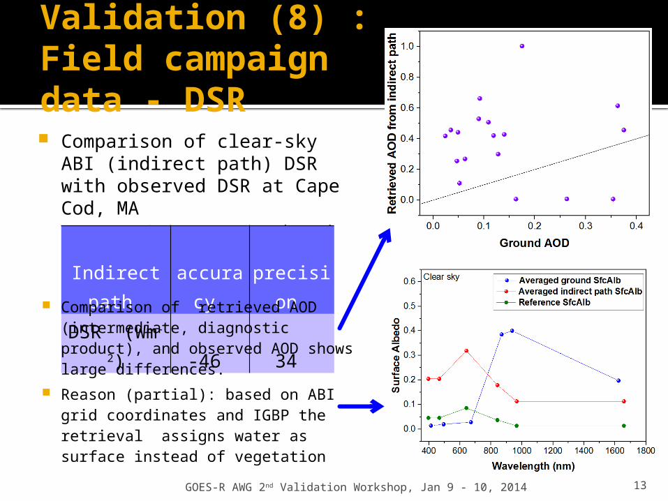
Validation (8) : Field campaign data - DSR Comparison of clear-sky ABI
(indirect path) DSR with observed DSR at Cape Cod, MA Large DSR errors – conducted deep
dive valIndirect
path
accurac
y
precisio
n DSR (Wm-2) -46 34
Comparison of retrieved AOD (intermediate, diagnostic product), and observed AOD shows large differences.
Reason (partial): based on ABI grid coordinates and IGBP the retrieval assigns water as surface instead of vegetation
GOES-R AWG 2nd Validation Workshop, Jan 9 - 10, 2014

14
Validation (9): Clear sky RSR validation at Cape Cod
3-way RSR retrievals (a): NTB + ADM + LUT
overwrite (red) [current indirect path]
(b): NTB, no ADM, + LUT overwrite (blue)
(c): NTB, no ADM, no LUT overwrite (green)
RSR (Wm-2)
accuracy
precision
(a) 58 19(b) 19 22(c) 12 18
Method (c) has the smallest bias and std More testing is needed!
GOES-R AWG 2nd Validation Workshop, Jan 9 - 10, 2014

15
Potential Algorithm Enhancements (1) Use ABI AOD product (when
available) in indirect path retrieval Currently using AOD retrieved internally
from broadband albedo Limited testing suggests reduction in
bias and std Candidate for transition to ops
Provide C and FD products (at least) at 5 km resolution Continuity of current capability - GOES
Surface Insolation Product (GSIP) will be at 4 km resolution in updated version
Tested Candidate for transition to ops
Add PAR to output Coral-health modeling needs PAR Already calculated internally Candidate for transition to ops
Figure: indirect path DSR retrieval error (red) and indirect path DSR retrieval error when MODIS AOD is used (blue).
Bias is decreased by 25 Wm-2.
GOES-R AWG 2nd Validation Workshop, Jan 9 - 10, 2014

16
Potential Algorithm Enhancements (2)
Get RSR directly from NTB and ADM conversion Do not overwrite with RSR calculated
from LUT Results from limited testing is on
previous slide More testing is needed!
Consider internal retrieval of narrowband surface albedo so direct path can be applied for DSR Tests showed DSR is better from direct
path (std is smaller) Research & development are needed
Consider mountain slope/shadowing effect Further research and algorithm
development are required
DSR Requirement
Direct Indirect
range bias
std
bias
std
bias
std
<200 110 100 24 48 57 98
[200,500]
65 130 -12 95 5 130
>500 85 100 -16 73 -13 84
GOES-R AWG 2nd Validation Workshop, Jan 9 - 10, 2014

17
Post-Launch Test/ Product Validation
Post-launch Test (checkout) period (L+~6months) Using data from last month of period:
▪ DSR is tested with ground-based measurements▪ RSR testing is likely to be done only indirectly, via DSR; real-time CERES
RSR is not expected to be available▪ DSR is compared with GSIP data (assumed to overlap with GOES-R for a few
months after launch) – checking consistency
Post-launch product validation (L+13 months) One month is needed to generate clear-composite for indirect path -
Twelve months of comprehensive validation activities are needed to achieve statistically representative validation results
Algorithm coefficient configuration ▪ Update/regenerate ABI-specific coefficients (NTB) with ABI data
RSR: evaluation with CERES data DSR: evaluation with existing ground network (SURFRAD) Re-derive “reference” statistics for routine monitoring/evaluation
GOES-R AWG 2nd Validation Workshop, Jan 9 - 10, 2014

18
Post-Launch Test/ Product Validation
Post-launch product validation (contd.) Tools developed during the pre-launch phase are used Generate DSR and RSR matchup data Collect/save input needed (ABI and ancillary) to re-process
retrievals for deep-dive evaluation, and Collect/save intermediate data (retrieved optical depth and
spectral surface albedo, direct and diffuse fluxes)▪ needed to identify source of error. It also allows for continual
improvement of the algorithm.▪ Data storage need may present a challenge!
Evaluation is stratified based on scene type, surface type, solar zenith angle, diurnal cycles and properties of cloud and aerosol.
No specific field campaigns have been identified, but plan on using atmosphere and surface data from field campaigns that provide data publicly (e.g., ARM).
GOES-R AWG 2nd Validation Workshop, Jan 9 - 10, 2014

19
Post-Launch Test/ Product Validation
Challenges Spatial and temporal averaging are needed, thus strict
validation of instantaneous product is not possible. Lack of extensive, permanent good-quality surface
observations over ocean. DSR validation will have to rely on limited costal and island stations.
For DSR validation, continued funding support to the SURFRAD network is required to continue the current level of data availability and consultation.
CERES data for validating RSR is available only with a substantial lag (days-months). All relevant satellite retrievals must be saved until the validation can be performed.
Saving intermediate data for deep-dive validation increases storage requirement.
GOES-R AWG 2nd Validation Workshop, Jan 9 - 10, 2014

20
Summary
Extended dataset for validation (~13 years) Proxy data are from MODIS and GOES Truth data are from ground measurement and CERES observation
Routine and deep-dive validation Established “Reference statistics“ for product monitoring Demonstrated deep-dive validation using data from field
measurements (Cape Cod)
Post-launch validation will apply tools developed in the pre-launch phase
Three potential algorithm enhancements are straightforward to implement (candidates for transitions to ops), three enhancements require more testing or substantial development
GOES-R AWG 2nd Validation Workshop, Jan 9 - 10, 2014