global positioning systems directorate p a c e a n d m i s s i l e s y s t e m s c e n t e r status...
TRANSCRIPT
Space and Missile Systems Center Space and Missile Systems Center
Global Positioning
Systems Directorate
16 Sep 2015
Col Steve Whitney
Director, SMC/GP
Space and Missile Systems Center

S P A C E A N D M I S S I L E S Y S T E M S C E N T E R
I n t e g r i t y - S e r v i c e - E x c e l l e n c e
1,200 Miles -
1,200 - 22,000 Miles -
22,000 Miles -
1,200 - 22,000 Miles -
A
600 Miles -
UNCLASSIFIED//FOUO 2
S P A C E A N D M I S S I L E S Y S T E M S C E N T E R S P A C E A N D M I S S I L E S Y S T E M S C E N T E R
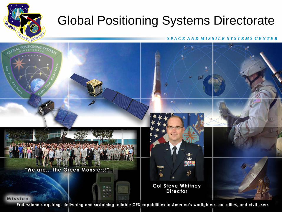
Global Positioning Systems Directorate
UNCLASSIFIED//FOUO
S P A C E A N D M I S S I L E S Y S T E M S C E N T E R
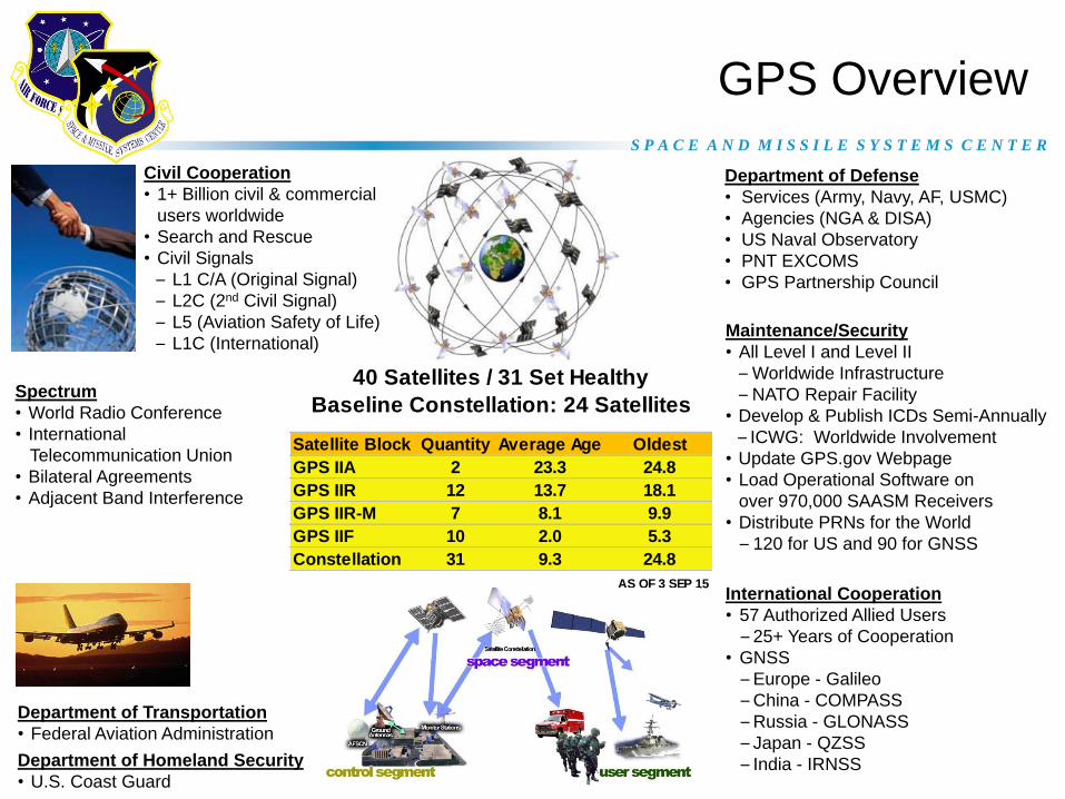
Satellite Block Quantity Average Age Oldest
GPS IIA 2 23.3 24.8
GPS IIR 12 13.7 18.1
GPS IIR-M 7 8.1 9.9
GPS IIF 10 2.0 5.3
Constellation 31 9.3 24.8
40 Satellites / 31 Set Healthy
Baseline Constellation: 24 Satellites
AS OF 3 SEP 15
GPS Overview
Department of Transportation
• Federal Aviation Administration
Department of Homeland Security
• U.S. Coast Guard
Department of Defense
• Services (Army, Navy, AF, USMC)
• Agencies (NGA & DISA)
• US Naval Observatory
• PNT EXCOMS
• GPS Partnership Council
International Cooperation
• 57 Authorized Allied Users
– 25+ Years of Cooperation
• GNSS
– Europe - Galileo
– China - COMPASS
– Russia - GLONASS
– Japan - QZSS
– India - IRNSS
Civil Cooperation
• 1+ Billion civil & commercial
users worldwide
• Search and Rescue
• Civil Signals
– L1 C/A (Original Signal)
– L2C (2nd Civil Signal)
– L5 (Aviation Safety of Life)
– L1C (International)
Spectrum
• World Radio Conference
• International
Telecommunication Union
• Bilateral Agreements
• Adjacent Band Interference
• International Committee
On Global Navigation Satellite
Systems (GNSS)
Maintenance/Security
• All Level I and Level II
– Worldwide Infrastructure
– NATO Repair Facility
• Develop & Publish ICDs Semi-Annually
– ICWG: Worldwide Involvement
• Update GPS.gov Webpage
• Load Operational Software on
over 970,000 SAASM Receivers
• Distribute PRNs for the World
– 120 for US and 90 for GNSS

S P A C E A N D M I S S I L E S Y S T E M S C E N T E R
Most aggressive GPS launch schedule since 1993
• 10 total GPS IIFs on-orbit
• 2 more GPS IIFs in the pipeline
– GPS IIF-11 in launch processing at Cape (30 Oct 15)
– GPS IIF-12 preparing to ship (3 Feb 16)
GPS IIF
5
1 Aug 14: IIF-7
15 Jul 15: IIF-10
29 Oct 14: IIF-8
25 Mar 15: IIF-9 20 Feb 14: IIF-5
16 May 14: IIF-6

S P A C E A N D M I S S I L E S Y S T E M S C E N T E R
Status
• GPS III is the newest block of GPS satellites
– 4 civil signals: L1 C/A, L1C, L2C, L5
• First satellites to broadcast common L1C signal
– 4 military signals: L1/L2 P(Y), L1/L2M
– Prime Contractor: Lockheed Martin (Waterton, CO)
• SV01-SV08 on contract; SV09 & SV10 options approved
• SV01 System Module Core Mate completed 7 Apr 15
– 2 year delay from baseline due to technical challenges w/ payload
• Mission Data Unit software qualification complete 6 Aug 15
• SV-level thermal vacuum scheduled for Fall 2015
• SV01 available for launch Aug 2016
GPS III

S P A C E A N D M I S S I L E S Y S T E M S C E N T E R
Status
• Competing GPS III SV11-32 Production – Drive down space vehicle costs by promoting effective competition
– Reduce production cost and schedule risk with minimal design phase
• Two-phase acquisition approach allows contractors time to mature designs – Phase 1: Production readiness feasibility assessment
• Phase 1 RFP release 1QFY16 with award in 3QFY16
• Gain insight into contractor-funded space vehicle and navigation payload production
design maturity and risk
• Full and open competition not to exceed $6M per source for up to 3 sources via firm
fixed price contract
– Phase 2: Full & open competition for GPS III SV11-32 production
• Projected award in FY18
• Acquisition strategy to be informed by Phase 1 performance and results
7
GPS III SV11+

S P A C E A N D M I S S I L E S Y S T E M S C E N T E R
• Modernized command & control system – GPS III command & control
– M-Code
– Robust cyber security infrastructure
– Modern civil signals & monitoring
– Improved PNT performance
• Prime: Raytheon (Aurora, CO)
• OCX Block 0: launch & checkout for GPS III – Currently in test
– Successfully completed seven launch exercises/simulations
• OCX Block 1: replaces AEP and LADO, operate & manage GPS constellation; control modernized civil (L1C, L2C, L5) & military signals “core capability” (L1M, L2M) – Currently in design and risk reduction testing
• OCX Block 2: adds advanced NAVWAR and Civil Signal Performance Monitoring capabilities
8
GPS Next Generation Operational
Control System (OCX)

S P A C E A N D M I S S I L E S Y S T E M S C E N T E R
Status
• Three vendors developing modernized
receiver cards (RCI, Raytheon L-3)
• Pursuing commercial market-driven
acquisition
• Initial test articles delivered Jul 2015
– Developmental test started 24 Aug 2015
9
Military GPS User Equipment (MGUE)
MGUE Components
A-Kit
(GB-GRAM-M)
GRAM SEM-E-M
(GRAM S/M)
NAVY
Arleigh Burke Class
Destroyer (DDG)
AIR FORCE
B-2 Spirit
Lead Platforms
ARMY
DAGR Distributed Device
Ground
Aviation &
Maritime
MARINESJoint Light Tactical
Vehicle (JLTV)
PNT
PNT
PNT
Lead Platforms
B-Kit
PNT
MAGR-2K
C4ISR System
GPNTS
IS-GPS-153
& MSID
GPS Interface
Control
Authority
IS-GPS-177
• MGUE program is in process of completing work to support a Milestone B decision
• Draft MGUE Increment 2 Capability Development Document in coordination;
defined as space receiver, hand-held, and Precision Guided Missile (PGM)

S P A C E A N D M I S S I L E S Y S T E M S C E N T E R
• Everyone loves GPS capabilities
• Engaged in modernization of the entire GPS Enterprise
– MGUE fielding is being accelerated via commercial market strategy
• Key driver -- statute for Services to field in FY17 & user equipment vulnerability to spoofers / jammers
– Next-Generation Operational Control System (OCX) addressing cost and schedule challenges
– Final GPS IIF Launch Campaigns underway
– GPS III first satellite is in the final stages of assembly and test, while work is underway to ensure future production capability
• Modernized Civil Navigation messages being broadcast today!
– Improved accuracy with new systems
– Better safety of life with multiple systems
10
Perspectives

S P A C E A N D M I S S I L E S Y S T E M S C E N T E R

S P A C E A N D M I S S I L E S Y S T E M S C E N T E R
12
Back-Up

S P A C E A N D M I S S I L E S Y S T E M S C E N T E R
Accuracy: Civil Commitments Standard Positioning Service (SPS) Performance Standard
[VALUE][VALUE][VALUE]
[VALUE][VALUE][VALUE]
[VALUE]
0
1
2
3
4
5
6
7
8
2001 2002 2003 2004 2005 2006 2007 2008 2009 2010 2011 2012 2013 2014
Use
r R
an
ge
Err
or
(UR
E)
in M
ete
rs
1.61.4
1.2 1.2 1.1 1.1 1.0 1.0 0.9 0.9 0.9 0.8 0.8 0.7
System accuracy better than published standard
Be
tte
r P
erf
orm
an
ce
Across All Healthy Satellites (RMS, 68%)
Worst of Any Healthy Satellite (95%)
Standard Positioning Service (SPS) Signal-in-Space Performance
Equivalent RMS Value from 2008 SPS PS (4 m)
2008 SPS Performance Standard (PS)
Worst of Any Healthy Satellite, 7.8 m @ 95%
Signal-in-Space User Range Error is the difference between a GPS
satellite’s navigation data (position and clock) and the truth, projected
on the line-of-sight to the user
Compare to (example):≈ 4.9 m RMS User residual iono delay error (L1 only)
≈ 0.5 m RMS User residual tropo delay error
2001 SPS PS 6 m RMS
3.43.1 3.0 3.2 3.3 3.1
2.9
PUBLICALLY RELEASABLE 13

S P A C E A N D M I S S I L E S Y S T E M S C E N T E R
Accuracy: Military Commitments Precise Positioning Service (PPS) Performance Standard
[VALUE]
3.3
3.0 2.93.1
3.33.1
2.8
0
1
2
3
4
5
6
2001 2002 2003 2004 2005 2006 2007 2008 2009 2010 2011 2012 2013 2014
Use
r R
an
ge
Err
or
(UR
E)
in M
ete
rs
System accuracy better than published standard
Be
tter
Perf
orm
an
ce
Precise Positioning Service (PPS) Signal-in-Space Performance
Across All Healthy Satellites (RMS, 68%)
Worst of Any Healthy Satellite (95%)
2007 PPS Performance Standard (PS)
Worst of Any Healthy Satellite, 5.9 m @ 95%
Equivalent RMS Value from 2007 PPS PS (3 m)
Signal-in-Space User Range Error is the difference between a GPS
satellite’s navigation data (position and clock) and the truth, projected
on the line-of-sight to the user
Compare to (example):≈ 0.4 m RMS user residual iono delay error (L1+L2)
≈ 0.5 m RMS user residual tropo delay error
4.0
1.51.3
1.1 1.1 1.0 1.0 0.9 0.9 0.8 0.8 0.8 0.8 0.7 0.7
2.9
PUBLICALLY RELEASABLE 14