global geospatial information management country report of
TRANSCRIPT

Zemljemerska ulica 12, 1000 Ljubljana T: 01 478 48 00
F: 01 478 48 34
www.gu.gov.si
Global Geospatial Information Management
Country Report of Slovenia
Submitted by: Tomaž Petek

Contents
SLOVENIA ......................................................................................................................................................... 3
THE SURVEYING AND MAPPING AUTHORITY OF THE REPUBLIC OF SLOVENIA ................................................. 3
INSPIRE DIRECTIVE ........................................................................................................................................... 5
SPATIAL DATA INFRASTRUCTURE IN SLOVENIA ................................................................................................ 6
COORDINATION OF THE SPATIAL DATA INFRASTRUCTURE IN SLOVENIA ................................................................................ 6 LEGAL FRAMEWORK ................................................................................................................................................. 9 USE OF SPATIAL DATA INFRASTRUCTURE IN SLOVENIA ...................................................................................................... 9 PRACTICAL EXAMPLES OF ACCESS TO SPATIAL INFORMATION IN SLOVENIA ......................................................................... 11
Slovenian INSPIRE geoportal ........................................................................................................................ 11 Portal PROSTOR ............................................................................................................................................ 13 Geoportal of the Slovenian Environment Agency ......................................................................................... 14 ...................................................................................................................................................................... 14 LPIS ............................................................................................................................................................... 15 STAGE ........................................................................................................................................................... 16 SPIN .............................................................................................................................................................. 16 Web portal Geopodia ................................................................................................................................... 17 iObčina.......................................................................................................................................................... 19 PISO .............................................................................................................................................................. 20
LINKS .............................................................................................................................................................. 21

Slovenia
Slovenia, a small country between Italy, Austria, Hungary and Croatia, is a combination of Alpine
beauty, majestic valleys and blue and turquoise colour lakes purified by their limestone surroundings.
Slovenia, officially the Republic of Slovenia is a nation state in southern Central Europe at the
crossroads of main European cultural and trade routes. It lies between latitudes 45° and 47° N, and
longitudes 13° and 17° E. The 15th meridian east almost corresponds to the middle line of the
country in the direction west‐east. The Geometrical Center of the Republic of Slovenia is located at
coordinates 46°07'11.8" N and 14°48'55.2" E. It lies in Slivna in the Municipality of Litija. Slovenia's
highest peak is Triglav (2,864 m or 9,396 ft); the country's average height above sea level is 557 m
(1,827 ft).
It covers 20,273 square kilometers (7,827 sq mi) and has a population of 2.06 million. It is a
parliamentary republic and a member of the European Union and NATO.
Four major European geographic units meet on the territory of Slovenia: the Alps, the Dinaric Alps,
the Pannonian Plain, and the Mediterranean, with a small portion of coastline along the Adriatic Sea.
The territory has a mosaic structure and a mountainous landscape and biological diversity. The
country is one of the most water‐rich in Europe, with a dense river network, a rich aquifer system,
and significant karstic underground watercourses. Around 11,859 km2 or 4,578sq mi is covered by
forests which presents 58.5% of the country. This makes Slovenia one of the most forested countries
in Europe.
Slovenia is in a rather active seismic zone because of its position on the small Adriatic Plate, which is
squeezed between the Eurasian Plate to the north and the African Plate to the south and rotates
counter‐clockwise. Many parts of Slovenia have a carbonate ground, and an extensive subterranean
system has developed.
The Surveying and Mapping Authority of the Republic of Slovenia
The Surveying and Mapping Authority of the Republic of Slovenia is a body within the Ministry of the
Environment and Spatial Planning. The competence of the Surveying and Mapping Authority of the
Republic of Slovenia comprises the tasks of the national land survey service, which include the
creation, management and updating of databases pertaining to the basic geodetic system, real
estate, the state border, spatial units and house numbers, and the Consolidated Cadastre of Public
Infrastructure, as well as the topographic and cartographic system.
The Surveying and Mapping Authority of the Republic of Slovenia is responsible for basic data on
space and real estate in the finalized databases, provides services pertaining to the registration of
changes in physical space and on real estate, and performs the role of coordinator for the real estate
system and spatial data infrastructure. In cooperation with the Ministry of Finance, it is carrying out a
mass real estate appraisal with the aim of creating the foundations for successful and efficient real
estate management, to provide data for objective and comprehensive real estate taxation and
improve the efficiency of the real estate market. It provides for the national coordinate system and
its compliance with the European coordinate system and creates the conditions for implementing
land surveys.
The Surveying and Mapping Authority of the Republic of Slovenia comprises: the Main Office, the
Real Estate Office, the Mass Real Estate Valuation Office, the Geodesy Office and twelve regional

surveying and mapping authorities. The latter have been set up to streamline operations and
increase the accessibility of administrative and professional tasks and services implemented by the
Surveying and Mapping Authority of the Republic of Slovenia.
Picture 1 Organizational chart of the Surveying and Mapping Authority of the Republic of Slovenia
In cooperation with the regional surveying and mapping authorities, the regional offices implement
the following joint tasks:
• preparing the national land survey service annual program and the report on its
implementation,
• organizing the work of the regional surveying and mapping authorities, monitoring their
work and ensuring the uniform implementation of national land survey service
assignments,
• directing the implementation of development assignments pertaining to surveying and
mapping activities,
• implementing operational, professional and administrative assignments from the offices’
fields of work,
• drafting regulations on surveying and mapping activities,
• meeting international obligations in the field of national land survey services.

INSPIRE Directive
INSPIRE represents the abbreviation for the Directive 2007/2/EC of the European Parliament and of
the Council of 14 March 2007 establishing an Infrastructure for Spatial Information in the European
Community (OJ L 108, 24.4.2007, p. 1), along with the Corrigendum to Directive 2007/2/EC of the
European Parliament and of the Council of 14 March 2007 establishing an Infrastructure for Spatial
Information in the European Community (OJ L 365, 19.12.2014, p. 165). The Directive was
implemented on 15 May2007 It establishes the legal framework for the establishment and operation
of an European spatial data infrastructure, which represents a collection of interoperable
infrastructures for spatial information of individual Member States. Its intended goal is to facilitate
the infrastructure for the access and re-use of spatial data to the broadest possible public and for the
broadest possible use, in broader terms to maximize the added value of spatial data appropriated
with public funds.
The INSPIRE Directive was transposed into the Slovenian legal system with the Infrastructure for
Spatial Information Act – ISI Act (Official Gazette of RS, No. 8/2010 and 84/2015), which
requires the enactment of a national contact point for the communication between INSPIRE
stakeholders and the European Commission as well as the establishment of a nation INSPIRE
geoportal.
The Surveying and Mapping Authority has established the national INSPIRE geoportal
(www.geoportal.gov.si). It includes a metadata system, INSPIRE glossary, links to some web
applications for data access and key information related to the INSPIRE Directive and its
implementation in Slovenia (list of events, list of spatial datasets and their managers,
regulations and materials, and other information)

Spatial data infrastructure in Slovenia
The Slovenian National Assembly adopted the ISI Act on 26 January 2010 and amended with
the Act Amending the Infrastructure for Spatial Information Act on 27 October 2015 on the
basis of an EU Pilot enquiry procedure of the European Commission. The ISI Act regulates the
establishment, management and maintenance of the infrastructure for spatial information in
the Republic of Slovenia as an integral part of the infrastructure for spatial information in
Europe relating to the establishment and operation of a metadata system, network services
to access the data and their use, coordination in establishing the infrastructure for spatial
information (ISI) and the use of this infrastructure. It also defines the tasks of individual
public entities responsible for establishing, managing and using spatial data and services,
which have to be provided as an integral part of the Slovenian and, thus, also European
infrastructure for spatial information.
Activities to establish the infrastructure for spatial information in Slovenia have become
organizationally embedded into a broader scheme of activities meant to manage and
harmonize spatial data – eSpatial. It represents a comprehensive strategy for the betterment
of processes in the field of spatial planning, construction and Real Estate management
achievable with linked (interoperable), easily accessible and reliable spatial datasets
managed and maintained by the public sector. Actions of the proposed eSpatial strategy are
further part of an even broader strategy of the public sector of the Republic of Slovenia –
eGovernment. The implementation of the eGovernment strategy encompasses the
establishment of the Governmental Strategic board for development of informatics in state
authority which steers the development of ICT systems in public administration and
manages their financial sources. Because of the intertwined and interdependent nature of
tasks for the establishment of the infrastructure for spatial information and tasks carried out
by the strategic board for development of informatics the Surveying and Mapping Authority
and the Ministry of the Environment and Spatial Planning proposed the establishment of a
Strategic board for geoinformatics which would operate as a part of the Strategic board for
development of informatics in state authority. The Strategic board for geoinformatics would
coordinate all strategic tasks with the establishment and management of the infrastructure
for spatial information in the Republic of Slovenia.
Coordination of the spatial data infrastructure in Slovenia
Different stakeholders cooperate in the Republic of Slovenia in the implementation of the
INSPIRE Directive, while arguably the main tasks of the implementation of the infrastructure
for spatial information is in the hands of the Surveying and Mapping Authority of the
Republic of Slovenia These main participants in the implementation of the INSPIRE Directive
are: the national contact point, the Intersectoral INSPIRE project group, managers of
datasets, individual public institutions and interested users. The key public authorities are as
follows:
• Ministry of the Environment and Spatial Planning, (www.mzip.gov.si/) and the bodies affiliated to it:
• Surveying and Mapping Authority of the Republic of Slovenia, (www.gu.gov.si)
• Slovenian Environment Agency (www.arso.gov.si) • Slovenian Water Agency (http://www.dv.gov.si/)
• Ministry of Infrastructure (http://www.mzi.gov.si/) and the bodies affiliated to it: • Slovenian Infrastructure Agency (http://www.di.gov.si/)
• Ministry of Agriculture, Forestry and Food, (http://www.mkgp.gov.si/) • Ministry of Defence (www.mo.gov.si/) the body affiliated to it:
• Administration of the Republic of Slovenia for Civil Protection and Disaster Relief, (www.sos112.si),
• Ministry of Culture, (www.mk.gov.si) • Ministry of Economic Development and Technology, (http://www.mgrt.gov.si/) • Ministry of Health, (www.mz.gov.si) • Ministry of Public Administration, (www.mju.gov.si) • Ministry of the Interior (www.mnz.gov.si) • Geological Survey of Slovenia, (www.geo-zs.si • Biotechnical Faculty, (www.bf.uni-lj.si • Slovenia Forest Service, (www.zgs.gov.si/) • Fisheries Research Institute of Slovenia, (www.zzrs.si), • Institute of the Republic of Slovenia for Nature Conservation, (www.zrsvn.si/) • Statistical Office of the Republic of Slovenia, (www.stat.si) • other ministries and local communities (municipalities).

Picture 2: Organizational structure of the Spatial data infrastructure in Slovenia
Legal Framework
Infrastructure for Spatial Information Act – ISI Act (Official Gazette of the RS, No. 8/10 and 84/2015).
The Act defines the tasks related to the establishment and operation of a metadata system, network
services to access the data and their use, coordination in establishing the infrastructure for spatial
information (ISI) and the use of this infrastructure. It also defines the tasks of individual public
entities responsible for establishing, managing and using spatial data and services, which have to be
provided as an integral part of the Slovenian and, also European infrastructure for spatial
information.
Act on georeference system (Official Gazette of the RS, No. 25/14)
This act introduces a new, modern national spatial reference system, which is based on the European
Spatial Reference System (ESRS), and a new national topographic system together with the new map‐
grid system. The scope of the new act is regulation of competences and tasks of the Surveying and
Mapping Authority of the Republic of Slovenia related to the realization and maintenance of the
national spatial reference system in long term and providing up–to–date spatial datasets and data
products.
Decree on communication and re‐use of information of public character (Official Gazette of the RS,
76/05, 119/07 and 95/11)
This Decree lays down the method by which public information shall be provided to applicants and
published on the World Wide Web, as well as the charging of costs for provision, re‐use of
information, price and other terms of such use and reporting on provision of access to public sector
information.
Public Information Access Act (Official Gazette of the RS, No. 51/06, 117/06‐ZDavP‐2, 23/14 and
50/14) This Act governs the procedure which ensures everyone free access to and re‐use of public
information held by state bodies, local government bodies, public agencies, public funds and other
entities of public law, public powers holders and public service contractors.
Use of spatial data infrastructure in Slovenia
All existing elements of the Slovenian infrastructure for spatial information are used mainly by the
institutions of the public administration. For several years, individual elements of the infrastructure
for spatial information have been available to the public. Such information contains mainly joint fast
communication network of public authorities (HKOM), managed and maintained by the Ministry of
Public Administration, which has been connecting all public authorities and some other public
institutions for many years. On the basis of the Act on the Access to Information of Public Character
and according to the Decree on re-use of information of public sector, every public authority must
publish on its website the »Catalogue of Public Information«, which enables the users a more
transparent access to the information managed and maintained by a particular public authority. In
these data, spatial information occupies an important position. The Ministry of Public Administration
is actively working on establishing a national interoperability framework (NIO). The National
interoperability framework provides information to public administration authorities as well
as other users regarding elements for interoperability provided by different authorities and
are available for use or are mandatory to consider and use when performing administrative
or other tasks as well as managing elements of data infrastructure. It also represents Slovenia
in the EU ISA program »Interoperability Solutions for European Public Administrations«. Cooperation

of the national administration in the EU ISA program offers an additional dimension of the ISI use in
Slovenia.
In the field of information and communication technology (ICT) and electronic commerce,
interoperability represents one of the most important conditions for a successful development of
information society, as it brings positive effects to the users (greater choice of services, increased
competition and, thus, also better quality at lower price, enabling the closing of information systems
and applications), as well as for the ICT industry (facilitating the entry to the market, sharing
knowledge, basis for the development of new innovative and competitive products and services).
This allows faster development and implementation of innovation (technological, organizational,
procedural) in the public administration and economy, which shall ensure faster dissemination of
knowledge, involvement, innovation and competition for society as a whole. The Ministry of Higher
Education, Science and Technology and the Ministry of Public Administration implemented a project
''Concept of national interoperability framework and test interoperability of the e-Vrtci (meaning e
Kindergartens) application''. From the outset the systematic establishment of the national e-
administration, the interconnection of official records has been one of the main problems impeding
faster development of electronic services of the types G2G, G2B and G2C. Due to lack of connectivity
standards the interconnection of data bases or applications is facing technical and organizational
problems related to harmonising interests, duties and rights of national (public) institutions.
All these activities are in line with the current global trend for open and free public data and Slovenia
has made some changes (legal and technical) to follow them. The Ministry for Public Administration,
which oversees the management and development of all ITC infrastructures of the public authorities
is in the process of preparing guideless and recommendations for the opening of public datasets to
the public and thus facilitate its use for neverbefore planed cases and generating added value and
economic growth.
Therefore the restrictions regarding access to public data (including spatial data) and the facilitation
of access to public information in Slovenia needed to be re-evaluation and regulated appropriately.
For those reasons an amendment of the Public Information Access Act (ZDIJZ-E) was passed. The
original Act was passed in 2003 with the intention to provide transparency in the use of public
administration funds. The latest amendment builds on this foundation and broadens the obligation
for transparency also for those institutions, which administer public funds, in other words national
funds, local government funds or funds of other public institutions.
This change is the first step for the Republic of Slovenia on the road to open data and it enables not
only the public administration access to certain products but also a broader user base which needs
them for their commercial activities. Coordinated and harmonized open data along with
improvements to data access will increase the potential for applications and the usefulness of data
gathered using public funds.
Practical benefits of an open data policy are not instantaneous but are more long term. Enough of
datasets need to be open and harmonized for their interoperability and reuse to for to its fullest
potential and in the future also enable the next level of data use – linked data.

Practical examples of access to spatial information in Slovenia
By taking into consideration general and specific indicators, it can be determined that, in regards to
the use the spatial data services for the infrastructure, today there are already a number of discover,
view, download and transformation network services in Slovenia
The Surveying and Mapping Authority of the Republic of Slovenia provides re-use of its datasets
through its website service to almost 30 public authorities and some private associations with the
average of almost 100,000,000 requests per year, while 2014 showed over 130,000,000 requests for
spatial data in light of interest for different project associated with spatial data. Monitoring hits at
their geoportal, the Slovenian Environment Agency recorded almost 8000 hits per month. Some hits
are generated also by service users.
Slovenian INSPIRE geoportal
The before mentioned Slovenian
INSPIRE geoportal
(http://www.geoportal.gov.si/eng/)
provides access to different spatial
datasets provided by different public
administrations and to the European
INSPIRE geoportal along with
services for spatial dataset
metadata. Its intended purpose is as
a national hub with access to all
necessary information regarding all
available spatial datasets.
At this moment only view network services are accessible via the Slovenian INSPIRE
geoportal in accordance with the provisions of the INSPIRE Directive and the ISI Act. In the
year 2015 a project for the establishment of a common infrastructure was carried out
named Establishment of INSPIRE compliant network systems. It encompassed the
establishment of INSPIRE compliant discovery, view and download network services along
with the prepared access to working services through the Slovene and European INSPIRE
geoportals. The first phase of the project covered the updating of existing hydrographic and
topographic data and the second phase of other INSPIRE spatial data themes under the
jurisdiction of the Surveying and Mapping Authority of the Republic of Slovenia into an
INSPIRE compliant structure. The services are not yet accessible to the public as they are in
the final stages of informational testing and control of adherence to the provision of the
INSPIRE Directive and ISI Act..


Portal PROSTOR
Several years ago the Surveying and Mapping Authority of the Republic of Slovenia
established its web portal PROSTOR (www.e-prostor.gov.si).
PROSTOR is a web portal, intended to improve access to geographical, surveying and other spatial
information in Slovenia. Beside access to data it offers also access to web services developed
according to open standards and geographical information systems.
The broad public has access to spatial data through the application “Javni vpogled v podatke o
nepremičninah” (Public viewer into real estate data) in accordance with public information laws and
restrictions.

Geoportal of the Slovenian Environment Agency
The Slovenian Environment Agency, as the
second largest manager of datasets relating
to INSPIRE in the country, has also
established its Geoportal
(www.gis.arso.gov.si) for datasets within its
competence.
The portal includes a metadata system, a
search engine and a browser for datasets,
WMS and WFS network services (viewing
and downloading) and a link to the web data
viewer (Environmental Atlas). The portal
allows access to more than 150 datasets.

LPIS
Land Parcel Information System (LPIS
– www.rkg.gov.si) is a system to
identify land use. It provides an
overview of data on land use of
agricultural holdings, records of
actual use of agricultural and forest
land, and certain other information:
orthophoto and other information
The Surveying and Mapping
Authority of the Republic of Slovenia
(maps, register of spatial units,
cadastral data, digital model of
relief), vineyard information, forestry
data, control layers for agricultural policy measures, bee pasture, water regulation, the soil map.

STAGE
The Statistical office of the Republic of Slovenia developed an interactive application for viewing and
downloading of geo-referenced statistical data based on different variables named STAGE
(http://gis.stat.si/). It provides access to more than 20 statistical datasets and more than 300
variables which can be displayed based on different territorial levels.
SPIN
Since 2005 Administration of the Republic of Slovenia for Civil Protection and Disaster Relief, use
their own application SPIN (www.spipn.sos112.si) ‐ Information system for the reporting of accidents
and intervention. Application SPIN is the result of collaboration Administration for Civil Protection
and Disaster Relief and representatives of the civil protection rescue and enables timely collection
and processing of data on accidents and interventions. The application allows instant capture data on
all natural and other disasters, the activation of protection and rescue units and informing all those
they need to be notified of activation. For a real time alert of user also provides an RSS feed
integration for users.

All the previously stated data access portals and viewer applications are managed by public
administration however in Slovenia there also exist spatial data portal provided by the private sector
as well as public crowdsourcing.
Web portal Geopodia
Geopedia (www.geopedia.si) is a prominent example of crowdsourced spatial data application in
Slovenia. It is a web based application for searching, viewing, and editing of geographical data, with
service available to many clients at the same time. It contains various kinds of geographical and geo‐
referenced information which comes from many different sources and is thoroughly described,
tagged, cross‐referenced and categorized.
Its user‐friendly web interface makes it easy to find items of interest – either through full text search
or via hierarchically organized categories – and to display them on interactive maps, which can be
saved for later viewing and manipulation.
Users can define and publish new layers with custom styling and textual descriptions, aggregate
related layers into custom maps and associate them with other sources of information. Its advanced
browser‐based geometry editor allows anyone to insert new geographical features or edit existing
one.

It its frame the development of special Geopedia projects – web applications for particular areas of
use have been established, appertaining to paragliding, hiking and public transport.

iObčina
iObčina Internet GIS (http://info.iobcina.si/iobcina3/index.php/en/what-is-iobina) is an IT system
that is used to search , view, ,quantity analyse of different elements, measuring distances and
surface areas of all kinds and types of spatial information that can be displayed on maps.
iObčina includes municipal, regional and national spatial information that are available to the broad
public or accessible with the authorization of the Republic of Slovenia.
The basic concept and idea of iObčine is that municipalities (local government) contractually agree to
rent the GIS system iObčina and in doing so authorize a specialized GIS team of the company Kaliopa
to manage and process data as needed by the employees of local government in their everyday work
and for the broader use and display for the public.
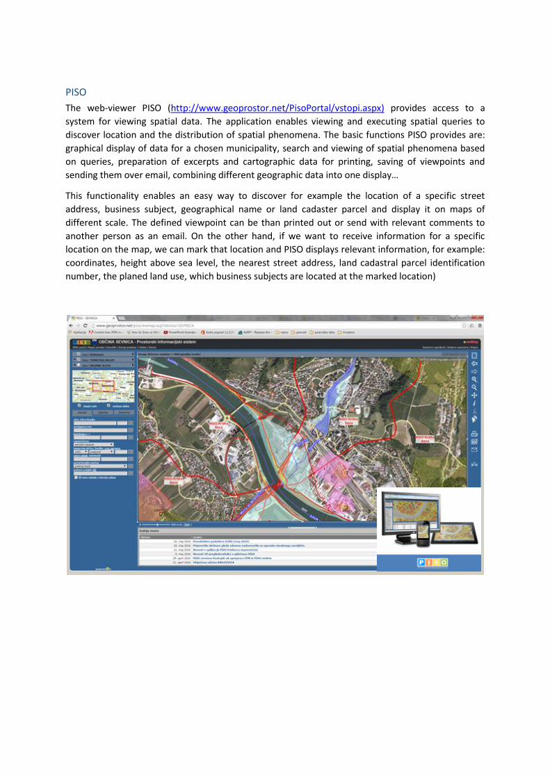
PISO
The web-viewer PISO (http://www.geoprostor.net/PisoPortal/vstopi.aspx) provides access to a
system for viewing spatial data. The application enables viewing and executing spatial queries to
discover location and the distribution of spatial phenomena. The basic functions PISO provides are:
graphical display of data for a chosen municipality, search and viewing of spatial phenomena based
on queries, preparation of excerpts and cartographic data for printing, saving of viewpoints and
sending them over email, combining different geographic data into one display…
This functionality enables an easy way to discover for example the location of a specific street
address, business subject, geographical name or land cadaster parcel and display it on maps of
different scale. The defined viewpoint can be than printed out or send with relevant comments to
another person as an email. On the other hand, if we want to receive information for a specific
location on the map, we can mark that location and PISO displays relevant information, for example:
coordinates, height above sea level, the nearest street address, land cadastral parcel identification
number, the planed land use, which business subjects are located at the marked location)

LINKS
The Surveying and Mapping Authority of the Republic of Slovenia
http://www.gu.gov.si
Slovenian INSPIRE geoportal www.geoportal.gov.si
Portal Prostor www.e‐prostor.gov.si
Geoportal ARSO www.gis.arso.gov.si
STAGE http://gis.stat.si/
Application SPIN www.spipn.sos112.si
Land Parcel Information System LPIS www.rkg.gov.si
Web Portal Geopedia www.geopedia.si
iObčina http://info.iobcina.si/iobcina3/
PISO http://www.geoprostor.net