global geocentric coordinate system … geocentric coordinate system november 7, 2012 wg d –...
TRANSCRIPT
111Космический комплекс ГНС ГЛОНАСС Международная конференция по спутниковой навигации ION GNSS 2012 17-21 сентября 2012 г., г. Нэшвилл, США
GLOBAL GEOCENTRIC COORDINATE SYSTEM
November 7, 2012 WG D – Reference Frames, Timing and Applications
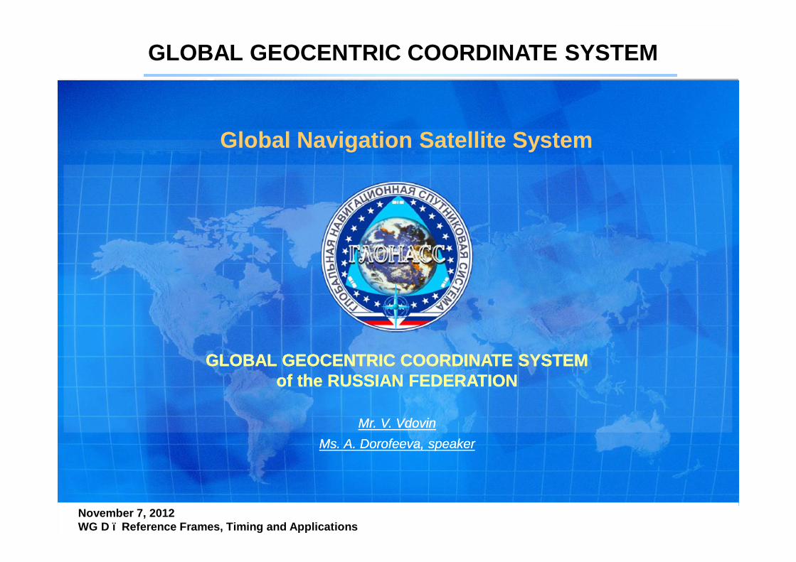
Global Navigation Satellite System
Mr. V. VdovinMs. A. Dorofeeva, speaker
Mr. V. VdovinMs. A. Dorofeeva, speaker
GLOBAL GEOCENTRIC COORDINATE SYSTEM of the RUSSIAN FEDERATION
GLOBAL GEOCENTRIC COORDINATE SYSTEM of the RUSSIAN FEDERATION

222Космический комплекс ГНС ГЛОНАСС Международная конференция по спутниковой навигации ION GNSS 2012 17-21 сентября 2012 г., г. Нэшвилл, США
GLOBAL GEOCENTRIC COORDINATE SYSTEM
November 7, 2012 WG D – Reference Frames, Timing and Applications
Coordinate system PZ-90 is the earth coordinate system.The definition of this coordinate system meets the criteria outlined in the PZ-90:- it’s geocentric, the center of mass is determined for the entire Earth, includingoceans and atmosphere;- size corresponds to the current state of knowledge about the values of the speedof light, geocentric gravitational constant, and the precision of satellite laserranging;- orientation corresponds to the recommendations of the International EarthRotation Service (IERS) and the International Bureau of time (BIH);- time evolution in orientation will not create a residual global rotation with
respect to the Earth's crust (the zero rate of rotation relative to ITRF2000);- It is fixed on the Earth surface by the points of space geodetic network- PZ-90 is a geodesic basis for GLONASS system and is used to provide satellite
orbital flights and navigation solutions. Users receive directly PZ-90 fromGLONASS.
INTRODUCTIONINTRODUCTION
333Космический комплекс ГНС ГЛОНАСС Международная конференция по спутниковой навигации ION GNSS 2012 17-21 сентября 2012 г., г. Нэшвилл, США
GLOBAL GEOCENTRIC COORDINATE SYSTEM
November 7, 2012 WG D – Reference Frames, Timing and Applications
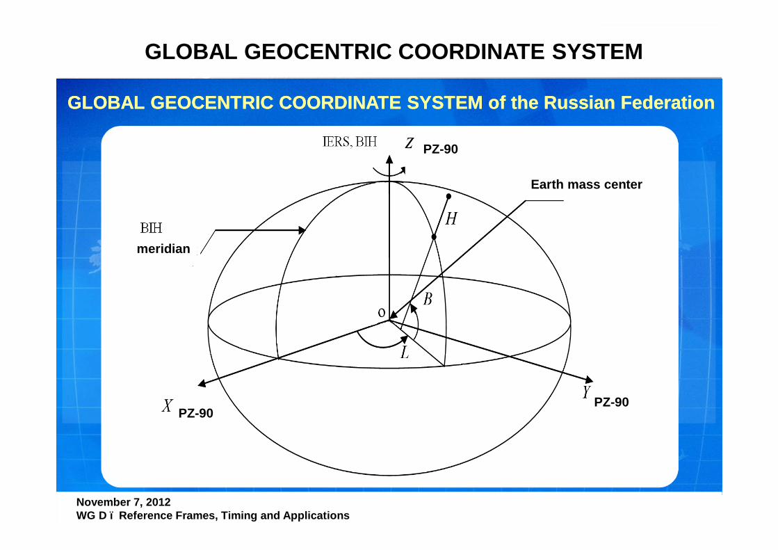
GLOBAL GEOCENTRIC COORDINATE SYSTEM of the Russian FederationGLOBAL GEOCENTRIC COORDINATE SYSTEM of the Russian Federation
Earth mass center
meridian
PZ-90PZ-90
PZ-90
444Космический комплекс ГНС ГЛОНАСС Международная конференция по спутниковой навигации ION GNSS 2012 17-21 сентября 2012 г., г. Нэшвилл, США
GLOBAL GEOCENTRIC COORDINATE SYSTEM
November 7, 2012 WG D – Reference Frames, Timing and Applications
Definition of the axes origins:
• Origin - center of mass of the Earth
• The Z-axis is directed towards the Earth's poles conditionally asdefined recommendations of the International Earth RotationService (IERS) and the International Bureau of time (BIH)
• The X axis is directed to the point of intersection of the equatorand the prime meridian established by the International Bureau ofthe time (BIH)
• The Y-axis completes the system to the right
Origin of PZ-90 also serves as the geometric center of commonterrestrial ellipsoid PZ-90 and Z-axis is the axis of the ellipsoid ofrotation
555Космический комплекс ГНС ГЛОНАСС Международная конференция по спутниковой навигации ION GNSS 2012 17-21 сентября 2012 г., г. Нэшвилл, США
GLOBAL GEOCENTRIC COORDINATE SYSTEM
November 7, 2012 WG D – Reference Frames, Timing and Applications
PZ-90 was created in composition of the Earth geodetic parameterssystem «Earth parameters» in 1990 using dynamic method of satellitegeodesy from joint equalization of the observations of geodetic satellitesGEOIK (1985-1989), GLONASS, ETALON and gravity data on land and theoceans derived from altimetry GEOIK. In the derivation of the PZ-90,except for the coordinate system, to refine the reference ellipsoidparameters and the model parameters and the gravitational field of theEarth. Such kinds of GEOIK measurements were used (photo, Doppler,radio and laser ranging, altimetry) together with global gravimetriccatalogue. Coordinate system PZ-90 is fixed by globally located points ofspace geodetic network. A number of GLONASS ground control points areidentified in the coordinate system PZ-90 and combined with the items ofspace geodetic system.
PZ-90 was created in composition of the Earth geodetic parameterssystem «Earth parameters» in 1990 using dynamic method of satellitegeodesy from joint equalization of the observations of geodetic satellitesGEOIK (1985-1989), GLONASS, ETALON and gravity data on land and theoceans derived from altimetry GEOIK. In the derivation of the PZ-90,except for the coordinate system, to refine the reference ellipsoidparameters and the model parameters and the gravitational field of theEarth. Such kinds of GEOIK measurements were used (photo, Doppler,radio and laser ranging, altimetry) together with global gravimetriccatalogue. Coordinate system PZ-90 is fixed by globally located points ofspace geodetic network. A number of GLONASS ground control points areidentified in the coordinate system PZ-90 and combined with the items ofspace geodetic system.

666Космический комплекс ГНС ГЛОНАСС Международная конференция по спутниковой навигации ION GNSS 2012 17-21 сентября 2012 г., г. Нэшвилл, США
GLOBAL GEOCENTRIC COORDINATE SYSTEM
November 7, 2012 WG D – Reference Frames, Timing and Applications
A modification of PZ-90 was made in 2005 and was named PZ-90.02.
In 2007 it was commissioned. State geocentric reference system"Parameters of the Earth 1990" in the version of PZ-90.02 is called PZ-90.02.
The following table shows the name, date of creation, the age andaccuracy characteristics of the implementation of the system ofcoordinates
name Date of creation datum
The accuracy of the geocentric position of
points
The accuracy of the relative position of points
PZ-90 1990 - 1 – 2 м (0,3 – 0,5) м / 2000 км PZ-90.02 2005 2002.0 0,3 – 0,5 м (0,02 – 0,03) м / 2000 км
777Космический комплекс ГНС ГЛОНАСС Международная конференция по спутниковой навигации ION GNSS 2012 17-21 сентября 2012 г., г. Нэшвилл, США
GLOBAL GEOCENTRIC COORDINATE SYSTEM
November 7, 2012 WG D – Reference Frames, Timing and Applications
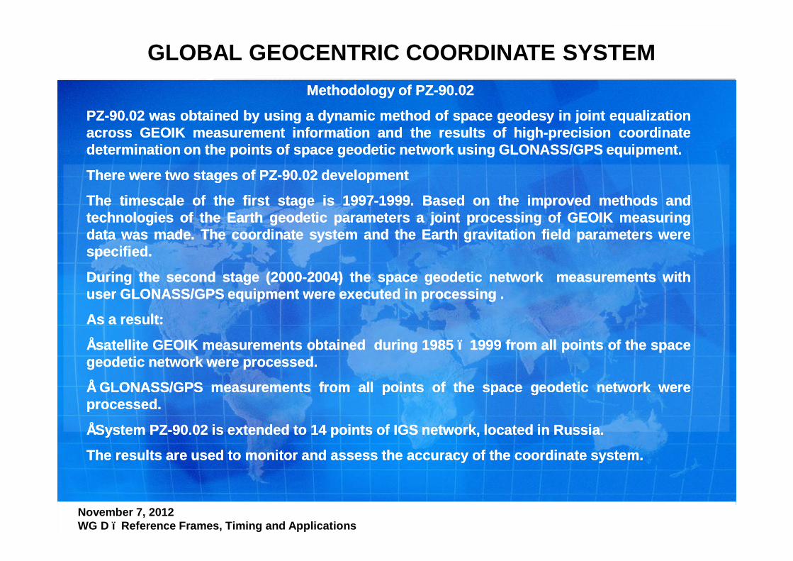
Methodology of PZ-90.02
PZ-90.02 was obtained by using a dynamic method of space geodesy in joint equalizationacross GEOIK measurement information and the results of high-precision coordinatedetermination on the points of space geodetic network using GLONASS/GPS equipment.
There were two stages of PZ-90.02 development
The timescale of the first stage is 1997-1999. Based on the improved methods andtechnologies of the Earth geodetic parameters a joint processing of GEOIK measuringdata was made. The coordinate system and the Earth gravitation field parameters werespecified.
During the second stage (2000-2004) the space geodetic network measurements withuser GLONASS/GPS equipment were executed in processing .
As a result:
• satellite GEOIK measurements obtained during 1985 – 1999 from all points of the spacegeodetic network were processed.
• GLONASS/GPS measurements from all points of the space geodetic network wereprocessed.
• System PZ-90.02 is extended to 14 points of IGS network, located in Russia.
The results are used to monitor and assess the accuracy of the coordinate system.
888Космический комплекс ГНС ГЛОНАСС Международная конференция по спутниковой навигации ION GNSS 2012 17-21 сентября 2012 г., г. Нэшвилл, США
GLOBAL GEOCENTRIC COORDINATE SYSTEM
November 7, 2012 WG D – Reference Frames, Timing and Applications
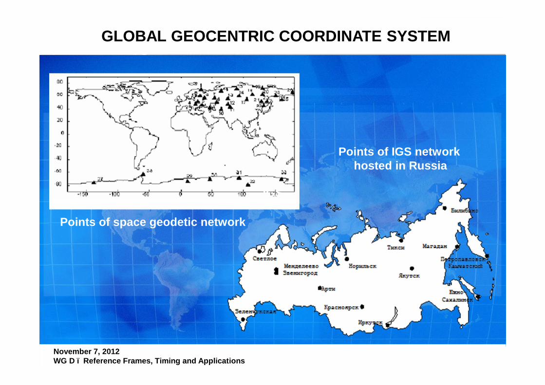
Points of IGS network hosted in Russia
Points of space geodetic network
IGS
999Космический комплекс ГНС ГЛОНАСС Международная конференция по спутниковой навигации ION GNSS 2012 17-21 сентября 2012 г., г. Нэшвилл, США
GLOBAL GEOCENTRIC COORDINATE SYSTEM
November 7, 2012 WG D – Reference Frames, Timing and Applications
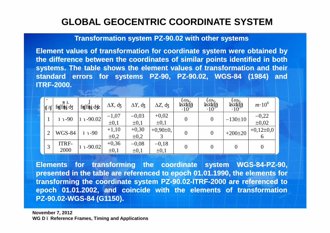
Transformation system PZ-90.02 with other systems
Element values of transformation for coordinate system were obtained bythe difference between the coordinates of similar points identified in bothsystems. The table shows the element values of transformation and theirstandard errors for systems PZ-90, PZ-90.02, WGS-84 (1984) andITRF-2000.
№ п/п
Из системы
В систему ∆X, м ∆Y, м ∆Z, м
(ωX, угл.с) ·103
(ωY, угл.с) ·103
(ωZ, угл.с) ·103
m·106
1 ПЗ-90 ПЗ-90.02 −1,07 ±0,1
−0,03 ±0,1
+0,02 ±0,1 0 0 −130±10 −0,22
±0,02
2 WGS-84 ПЗ-90 +1,10 ±0,2
+0,30 ±0,2
+0,90±0,3 0 0 +200±20 +0,12±0,0
6
3 ITRF-2000 ПЗ-90.02 +0,36
±0,1 −0,08 ±0,1
−0,18 ±0,1 0 0 0 0
Elements for transforming the coordinate system WGS-84-PZ-90,presented in the table are referenced to epoch 01.01.1990, the elements fortransforming the coordinate system PZ-90.02-ITRF-2000 are referenced toepoch 01.01.2002, and coincide with the elements of transformationPZ-90.02-WGS-84 (G1150).
Elements for transforming the coordinate system WGS-84-PZ-90,presented in the table are referenced to epoch 01.01.1990, the elements fortransforming the coordinate system PZ-90.02-ITRF-2000 are referenced toepoch 01.01.2002, and coincide with the elements of transformationPZ-90.02-WGS-84 (G1150).
101010Космический комплекс ГНС ГЛОНАСС Международная конференция по спутниковой навигации ION GNSS 2012 17-21 сентября 2012 г., г. Нэшвилл, США
GLOBAL GEOCENTRIC COORDINATE SYSTEM
November 7, 2012 WG D – Reference Frames, Timing and Applications
FUTURE PLANS
Currently, Ministry of Defense of RF has prepared a new draft version ofPZ-90 - PZ-90.11 (epoch 2010.0). Only geocentric coordinate system PZ-90.02 was specified. The measurements from GLONASS/GPS points ofspace geodetic network, IGS network stations located in Russia, andglobal Doppler measurements from DORIS were used to obtain PZ-90.11.
According to preliminary estimates, the error (root mean square) ofPZ-90.11 origin position relatively to the center of mass of the Earth ischaracterized by 0.05 m, and angular error 0.001 angular seconds. Theerror of the mutual position of the points of space geodetic network is0.005 - 0.01 m based on distance about 4000 km.
The elements of transformation and errors (root mean square) are definedfor systems PZ-90.02, PZ-90.11 and ITRF-2008.
The meridian position, the linear scale and the system origin of PZ-90.11are agreed with ITRF-2008 to epoch 2010.0.
111111Космический комплекс ГНС ГЛОНАСС Международная конференция по спутниковой навигации ION GNSS 2012 17-21 сентября 2012 г., г. Нэшвилл, США
GLOBAL GEOCENTRIC COORDINATE SYSTEM
November 7, 2012 WG D – Reference Frames, Timing and Applications
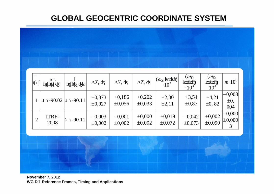
№ п/п Из
системы В
систему ∆X, м ∆Y, м ∆Z, м (ωX,угл.с) ·103
(ωY, угл.с) ·103
(ωZ, угл.с) ·103
m·106
1 ПЗ-90.02 ПЗ-90.11 −0,373 ±0,027
+0,186 ±0,056
+0,202 ±0,033
−2,30 ±2,11
+3,54 ±0,87
−4,21 ±0, 82
−0,008 ±0, 004
2 ITRF-2008 ПЗ-90.11 −0,003
±0,002 −0,001 ±0,002
+0,000 ±0,002
+0,019 ±0,072
−0,042 ±0,073
+0,002 ±0,090
−0,000 ±0,000
3
121212Космический комплекс ГНС ГЛОНАСС Международная конференция по спутниковой навигации ION GNSS 2012 17-21 сентября 2012 г., г. Нэшвилл, США
GLOBAL GEOCENTRIC COORDINATE SYSTEM
November 7, 2012 WG D – Reference Frames, Timing and Applications
FUTURE PLANS (2)
In 2011 ROSREESTR of RF (responsible for geodesy and cartography)created a new geodetic coordinate system which is used for regionalGLONASS application .
This geodetic coordinate system is fixed by points of the state geodeticnetwork (StGN).
According to the «Main statements on SGN of RF» the StGN includes:
- Fundamental astronomic - geodetic points (50 points);
- Points of high-precision geodetic network (300 points);
- Points of satellite geodetic network of 1st class (SGN-1 - about 4000points).

131313Космический комплекс ГНС ГЛОНАСС Международная конференция по спутниковой навигации ION GNSS 2012 17-21 сентября 2012 г., г. Нэшвилл, США
GLOBAL GEOCENTRIC COORDINATE SYSTEM
November 7, 2012 WG D – Reference Frames, Timing and Applications
Arrangement map ofFundamental astronomic - geodetic points and
Points of high-precision satellite geodetic network (SGN-1)
Arrangement map ofFundamental astronomic - geodetic points and
Points of high-precision satellite geodetic network (SGN-1)
141414Космический комплекс ГНС ГЛОНАСС Международная конференция по спутниковой навигации ION GNSS 2012 17-21 сентября 2012 г., г. Нэшвилл, США
GLOBAL GEOCENTRIC COORDINATE SYSTEM
November 7, 2012 WG D – Reference Frames, Timing and Applications
FUTURE PLANS (3)
Presently the parameters of the PZ-90.11 and new geodetic coordinatesystem of RF (including the coordinates of the points SGN and StGN) areunder agreement process.
The possibility of free access to the coordinates of SGN and StGN pointslocated on Russian territory is under consideration.
It is supposed to clarify and revise the PZ-90 each 5 years.
151515Космический комплекс ГНС ГЛОНАСС Международная конференция по спутниковой навигации ION GNSS 2012 17-21 сентября 2012 г., г. Нэшвилл, США
GLOBAL GEOCENTRIC COORDINATE SYSTEM
November 7, 2012 WG D – Reference Frames, Timing and Applications
Thank You for attention!Thank You for [email protected]@YANDEX.RU