gleim pilot handbook...a. a private pilot may act as pilot in command of an aircraft without holding...
TRANSCRIPT

Page 1 of 14
Gleim Pilot HandbookEleventh Edition, 1st Printing
UpdatesDecember 2017
NOTE: Text that should be deleted is displayed with a line through it. New text is shown with a blue background.
If you are tested on any content not represented in our materials or this update, please share this information with Gleim so we can continue to provide the most complete test preparation experience possible. You can submit feedback at www.GleimAviation.com/questions. Thank you in advance for your help!
The changes in this update reflect current FAA literature and procedures.
Introduction and Overview of Certificates and Ratings
Page 5, FAA Requirements to Obtain a Private Pilot Certificate, Item 3.c.2):
2) Also, the FAA publishes a directory that lists all authorized AMEs by name and address. Copies of this directory are kept at most FAA offices, ATC facilities, and Flight Service Stations (FSSs). Alternatively, go to the Gleim website at www.gleim.com/aviation/amesearch.php. You can access the directory at www.faa.gov/pilots/amelocator.
Copyright © 2017 Gleim Publications, Inc. All rights reserved. Duplication prohibited. Reward for information exposing violators. Contact [email protected].

Page 2 of 14
Page 8, FAA Requirements to Obtain an Instrument Rating, Item 3.c.3):
3) Alternatively, you can go to the FAA website (www.faa.gov) and enter “AME” in the search box on the home page or to the Gleim website at www.gleim.com/aviation/amesearch.php.
Page 10, FAA Requirements to Obtain a Commercial Pilot Certificate, Item 3.c.1):
c. Your certificated flight instructor (CFI) or fixed-base operator (FBO) will be able to recommend an AME.
1) This listing is also available via the FAA website (www.faa.gov) and the Gleim website at www.gleim.com/aviation/amesearch.php.
Page 12, FAA Requirements to Obtain a Commercial Pilot Certificate, Item 10.:
10. Successfully complete a practical (flight) test, which will be given as a final exam by an FAA inspector or designated pilot examiner. The flight test will be conducted as specified in the FAA’s Commercial Pilot Practical Test Airman Certification Standards (FAA-S-8081-12C ACS-7).
a. FAA inspectors are FAA employees and do not charge for their services.
b. FAA-designated pilot examiners are proficient, experienced flight instructors and pilots who are authorized by the FAA to conduct practical tests. They do charge a fee.
c. The FAA’s Commercial Pilot Practical Test Airman Certification Standards are outlined and reprinted in the Gleim Commercial Pilot Flight Maneuvers and Practical Test Prep book.
Copyright © 2017 Gleim Publications, Inc. All rights reserved. Duplication prohibited. Reward for information exposing violators. Contact [email protected].

Page 3 of 14
Study Unit 2 – Airplane Instruments, Engines, and Systems
Page 98, Subunit 2.12, Item 2.b.3) image updated:
Copyright © 2017 Gleim Publications, Inc. All rights reserved. Duplication prohibited. Reward for information exposing violators. Contact [email protected].

Page 4 of 14
Study Unit 4 – Federal Aviation Regulations
Page 246, Subunit 4.6, Subpart E, 14 CFR 61.113, new Item 7.:
7. On May 1, 2017, third-class medical reform, known as BasicMed, became effective.
a. A private pilot may act as pilot in command of an aircraft without holding a medical certificate issued under Part 67 provided the pilot holds a valid U.S. driver’s license, meets the requirements of 14 CFR 61.23(c)(3), and complies with this section and all of the following conditions and limitations:
1) The aircraft is authorized to carry no more than six occupants, has a maximum takeoff weight of no more than 6,000 lb., and is operated with no more than five passengers on board.
2) The flight, including each portion of the flight, is not carried out
a) At an altitude that is more than 18,000 ft. above mean sea level,
b) Outside the United States unless authorized by the country in which the flight isconducted, or
c) At an indicated airspeed exceeding 250 kt.
3) The pilot has available in his or her logbook
a) The completed medical examination checklist required under 14 CFR 68.7 andb) The certificate of course completion required under 14 CFR 61.23(c)(3).
Study Unit 7 – Aviation Weather
Page 371, Subunit 7.5, Item 5.:
5. Frost forms in much the same way as dew. The difference is that the dew point of surrounding air must be colder than freezing. Water vapor sublimates changes directly as toice crystals or frost (deposition) rather than condensing as dew.
Page 383, Subunit 7.12, Item 5.:
5. Precipitation-induced Frontal fog forms when relatively warm rain falls through cool air; evaporation from the precipitation saturates the cool air and forms fog.
a. Precipitation-induced Frontal fog can become quite dense and continue for a long time. b. It is most commonly associated with warm fronts. c. It occurs near other possible hazards, such as icing, turbulence, and thunderstorms.
Study Unit 8 – Aviation Weather Services
Page 400, Subunit 8.5, Item 1.d.:
d. The FAA has announced plans to discontinue issuing area forecasts, possibly in late 2016. The FAs are expected to be replaced with more effective digital products. The area forecast has been produced since the 1930s but will eventually be replaced by theGraphical Forecast for Aviation (GFA) for the continental U.S. and Hawaii.
1) The Caribbean, Gulf of Mexico, and Alaska area forecasts will remain unchanged.
2) Although the GFA product is already available, area forecasts are still being produced for a short period of time for the affected areas.
Copyright © 2017 Gleim Publications, Inc. All rights reserved. Duplication prohibited. Reward for information exposing violators. Contact [email protected].

Page 5 of 14
Page 402, New Subunit 8.6 (subsequent subunits were renumbered accordingly):
8.6 GRAPHICAL FORECASTS FOR AVIATION (GFA)
1. An FAA-NWS joint-agency working group recently recommended that the area forecast (FA) be transitioned to more modern digital and graphical forecasts, observations, and communications capabilities that provide improved weather information to decision-makers.
a. The result of this effort is the Graphical Forecasts for Aviation (GFA).
2. GFA are intended to provide the necessary aviation weather information to give users a complete picture of the weather that may impact flight in the continental U.S. (CONUS).
a. The GFA web page includes observational data, forecasts, and warnings that can be viewed from 14 hr. in the past to 15 hr. in the future, including thunderstorms, clouds, flight category, precipitation, icing, turbulence, and wind.
b. Hourly model data and forecasts, including information on clouds, flight category, precipitation, icing, turbulence, wind, and graphical output from the National Weather Service’s National Digital Forecast Data (NDFD), are available.
c. Wind, icing, and turbulence forecasts are available in 3,000-ft. increments from the surface up to 30,000 ft. MSL, and in 6,000-ft. increments from 30,000 ft. MSL to FL480 (48,000 ft. MSL). Turbulence forecasts are also broken into LO (below 18,000 ft. MSL) and HI (at or above 18,000 ft. MSL) graphics.
d. A maximum icing graphic and maximum wind velocity graphic (regardless of altitude) arealso available.
e. Built with modern geospatial information tools, users can pan and zoom to focus on areas of greatest interest.
f. GFA can be accessed at: www.aviationweather.gov/gfa.
3. A GFA forecast for turbulence intensity at the 9,000-ft. level at 2100Z is shown below.
Copyright © 2017 Gleim Publications, Inc. All rights reserved. Duplication prohibited. Reward for information exposing violators. Contact [email protected].

Page 6 of 14
Pages 408-410, Deleted Subunit 8.9, “Weather Depiction Chart” (subsequent subunits were renumbered accordingly).
Page 410, New Subunit 8.10 (subsequent subunits were renumbered accordingly):
8.10 CEILING AND VISIBILITY ANALYSIS (CVA)
1. The CVA product provides a real-time analysis of current observed and estimated ceiling andvisibility conditions across the continental U.S. (CONUS).
a. The product is primarily intended to help the general aviation pilot [particularly the VisualFlight Rules (VFR)-only pilot] avoid instrument flight rules (IFR) conditions. However, the CVA’s overview of ceiling and visibility conditions can be useful to others involved inflight planning or weather briefing.
b. CVA is issued every 5 min. and is available through www.aviationweather.gov.
2. CVA presents information via a full-CONUS graphic and 18 regional graphics.
a. Each graphic is rendered on a horizontal grid of 5-km. resolution and shows viewer-selectable representations of ceiling height (AGL), surface visibility in statute miles (SM), and flight category designation.
b. Each regional display includes an overlay of station plots showing the current ceiling andvisibility observations reported at selected METAR stations.
3. The image below shows the flight category (VFR, MVFR, IFR, LIFR) and areas with possible terrain obscurations.
Copyright © 2017 Gleim Publications, Inc. All rights reserved. Duplication prohibited. Reward for information exposing violators. Contact [email protected].

Page 7 of 14
4. The CVA is an analysis of estimated real-time conditions only. It is not a forecast and cannot be used in place of a forecast.
a. Impacted ceiling and visibility conditions can be highly localized and smaller in scale than the 5-km. grid used to convey CVA information. Thus, small-scale variations in ceiling and visibility conditions may not be represented by CVA, even in regions close to observing stations.
b. You can zoom in from a high-level national display to regional and local areas.
5. General aviation pilots, weather briefers, and others involved in flight planning can use CVA as a companion to METARs, TAFs, and AIRMETs to help them recognize and avoid IFR conditions.
a. Along with the foregoing weather information sources, the CVA can aid IFR avoidance and escape for an en route pilot who inadvertently encounters IFR conditions.
b. Pilots and flight planners must exercise judgment when using CVA information because it is based on recent weather information and calculated estimations. Degrading conditions are more likely as the distance and time increase from the station’s reported weather.
Page 424, Subunit 8.15:
8.15 16 AVIATION WEATHER RESOURCES ON THE INTERNET
1. Gleim recommends using official aviation weather resources, such as DUATS or Leidos Flight Service or DUATS, to obtain your aviation weather information.
a. Flight Service (Online): www.1800wxbrief.com
1) Leidos is the official Flight Service FAA contracted provider. Its services include answering all types of flight service contacts through telephone, airborne, and online. According to its website, Leidos provides services to more than 80,000 general aviation community members weekly.
2) Many products can be accessed without signing up or logging in; however, official briefings may be accessed only after logging in to an account.
3) The main menu provides access to a pilot dashboard, weather, flight planning and briefing, airport information, account, links, and help information.
4) A user guide and helpful videos with extensive instructions are available under the Help menu.
b. Direct User Access Terminal System (DUATS): www.duats.com
1) The DUATS is a computerized weather briefing and flight planning system that provides pilots with up-to-date and reliable briefing information.
2) After creating an account and logging in, users have many options to obtain aviationweather, charts, images, and preflight briefing tools.
3) A user guide with extensive instructions is available under the Help menu.
2. There are numerous other sites on the Internet that distribute syndicated weather informationor repackaged weather information derived from official sources.
a. Although other sources may not be official, they are a convenient way to access a wide range of weather products quickly.
b. Remember to always use official sources for navigation and flight planning. Most sites do not provide an official weather briefing and cannot be used to prove that you obtained sufficient weather information and NOTAMs pertinent to your flight.
Copyright © 2017 Gleim Publications, Inc. All rights reserved. Duplication prohibited. Reward for information exposing violators. Contact [email protected].

Page 8 of 14
c. The following sites are popular weather resources for pilots.
1) Gleim Aviation Weather: at www.gleim.com/aviation/weather contains links www.gleimaviation.com/resources/weather
a) Links to National Weather Service radar images as well as METAR/TAF reportsby airport, winds aloft, and area forecast reports. An easy, one-stop aviation weather information resource.
Copyright © 2017 Gleim Publications, Inc. All rights reserved. Duplication prohibited. Reward for information exposing violators. Contact [email protected].

Page 9 of 14
Study Unit 9 – Navigation: Charts, Publications, Flight Computers
Page 427, Subunit 9.1, Item 1.:
1. Aeronautical Information Services, which is part of the FAA, FAA-Approved Print Providers publishes and distributes digital aeronautical charts of the United States and foreign areas. Digital versions of VFR charts are provided by the FAA at www.faa.gov/air_traffic/flight_info/aeronav/digital_products/vfr. The types of charts most commonly used by pilots flying VFR include
Page 437, Subunit 9.3, Item 2.b.3) image corrected:
3) Class B airspace is shown on the sectional chart (below left) and on the diagram (below right).
Page 442, Subunit 9.6, Item 1.:
1. The Chart Supplement U.S. is published and distributed every 56 days by Aeronautical Information Services, a division of the FAA-Approved Print Providers.
Page 444, Subunit 9.7, Item 2.a.5):
5) NOTAM (D) information will remain available for the duration of its validity or until it is published in the Notices to Airmen Publication (NTAP).
a) The NTAP is issued every 28 days and is an integral part of the NOTAM system. Once a NOTAM is published in the NTAP, the NOTAM is not provided during pilot weather briefings unless specifically requested.
b) If you request information from a published NOTAM during a telephone weatherbriefing, be aware that the briefer will have to search for it. This can significantly increase your call time.
Copyright © 2017 Gleim Publications, Inc. All rights reserved. Duplication prohibited. Reward for information exposing violators. Contact [email protected].

Page 10 of 14
Page 451, Subunit 9.11, Item 7.:
7. Answers to practice problems
a. 123 SM b. 160 SM c. 157 SM NMd. 68 NM e. 368 SM
Page 471, Subunit 9.25, Items 1.a. and 1.b.:
1. Three boxes provide information.
a. The first, or top, box is the sequence of information required for filing a includes commonICAO flight plan equipment codes and surveillance codes.
b. The middle box contains the special equipment codes used for item 3. on the flight plan sequence shows the standard holding pattern entries.
Copyright © 2017 Gleim Publications, Inc. All rights reserved. Duplication prohibited. Reward for information exposing violators. Contact [email protected].

Page 11 of 14
Study Unit 10 – Navigation Systems
Page 477, Subunit 10.1, re-title the subunit and delete item 1., Definitions. Renumber subsequent items.
10.1 BASIC RADIO PRINCIPLES CHARACTERISTICS OF RADIO WAVES
1. Definitions
[ . . . ]2. Characteristics of Radio Waves
a 1. Radio waves dissipate as they encounter resistance from the environment.
1) a. Mountain ranges, trees, water, and land all dissipate the energy of radio signals, reducing their strength.
2) b. Radio waves that travel into the upper atmosphere are also affected as energy is absorbed by molecules of air, water, and dust.
b 2. A radio wave normally radiates from an antenna in all directions.
1) a. Part of the energy travels along the ground (ground wave) until its energy is dissipated.2) b. The remainder of the transmitted energy travels upward into space (sky wave).
c 3. The characteristics of radio waves vary according to their frequency, as do the behaviors oftheir ground and sky waves.
1) a. These characteristics determine the design, use, and limitations of both ground and airborne equipment.
d 4. Low frequency (LF) radio waves.
1) a. At frequencies below 300 kHz, there is substantial energy in the ground and sky waves.
2) b. The sky wave is reflected by the ionosphere by highly charged particles (ions) causedby the Sun’s radiation.
a 1) This reflection of the radio wave permits reception of the signals at varying distances from the antenna.
b 2) The transmission distance is determined by factors such as the height and densityof the ionosphere (which varies with the time of day, seasons, and latitude due to the Sun’s radiation) and the angle at which the radio wave strikes the ionosphere.
Copyright © 2017 Gleim Publications, Inc. All rights reserved. Duplication prohibited. Reward for information exposing violators. Contact [email protected].

Page 12 of 14
3) c. The distance between the transmitting antenna and the point where the sky wave first returns to the ground is called the skip distance.
a 1) The distance between the point where the ground wave can no longer be receivedand the sky wave returns is the skip zone.
4) d. Since solar radiation varies the height and density of the ionosphere, great changes in skip distances occur at dawn and dusk when fading of signals is more prevalent.
e 5. Very high frequency (VHF) and ultra high frequency (UHF) radio waves.
1) a. At frequencies above 30 MHz, there is practically no ground wave and ordinarily no reflection of the sky wave by the ionosphere.
2) b. Use of VHF/UHF signals is possible only if the transmitting and/or receiving antennas are raised sufficiently above the surface of the Earth to allow the use of a direct wave.
a 1) This is known as line-of-sight transmission.
3) c. Since most of your airplane’s radio navigation and all the communication radios operate in the VHF/UHF band, it is vital that you understand the importance of this limitation.
4) d. The use of VHF/UHF radio waves is limited by the position of the receiver in relation to the transmitter, as shown below.
a 1) Thus, the range of VHF/UHF transmission increases with altitude.
Copyright © 2017 Gleim Publications, Inc. All rights reserved. Duplication prohibited. Reward for information exposing violators. Contact [email protected].
Page 13 of 14
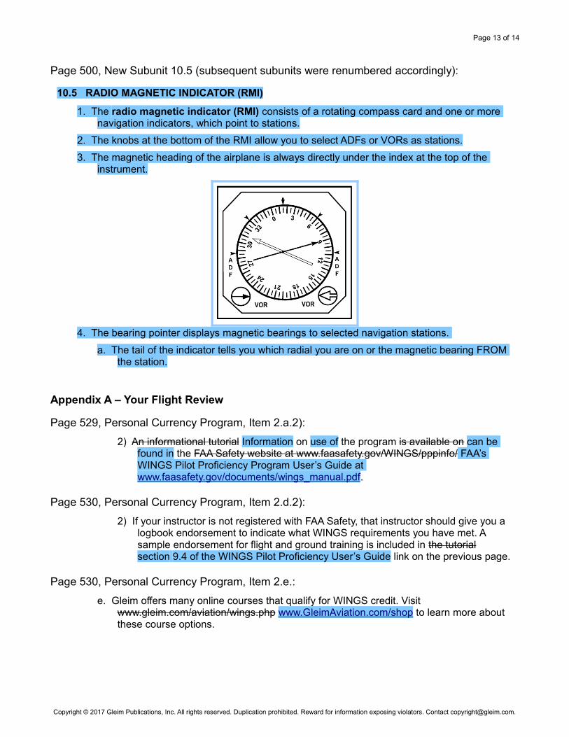
Page 500, New Subunit 10.5 (subsequent subunits were renumbered accordingly):
10.5 RADIO MAGNETIC INDICATOR (RMI)
1. The radio magnetic indicator (RMI) consists of a rotating compass card and one or more navigation indicators, which point to stations.
2. The knobs at the bottom of the RMI allow you to select ADFs or VORs as stations.
3. The magnetic heading of the airplane is always directly under the index at the top of the instrument.
4. The bearing pointer displays magnetic bearings to selected navigation stations.
a. The tail of the indicator tells you which radial you are on or the magnetic bearing FROM the station.
Appendix A – Your Flight Review
Page 529, Personal Currency Program, Item 2.a.2):
2) An informational tutorial Information on use of the program is available on can be found in the FAA Safety website at www.faasafety.gov/WINGS/pppinfo/ FAA’s WINGS Pilot Proficiency Program User’s Guide at www.faasafety.gov/documents/wings_manual.pdf.
Page 530, Personal Currency Program, Item 2.d.2):
2) If your instructor is not registered with FAA Safety, that instructor should give you a logbook endorsement to indicate what WINGS requirements you have met. A sample endorsement for flight and ground training is included in the tutorial section 9.4 of the WINGS Pilot Proficiency User’s Guide link on the previous page.
Page 530, Personal Currency Program, Item 2.e.:
e. Gleim offers many online courses that qualify for WINGS credit. Visit www.gleim.com/aviation/wings.php www.GleimAviation.com/shop to learn more about these course options.
Copyright © 2017 Gleim Publications, Inc. All rights reserved. Duplication prohibited. Reward for information exposing violators. Contact [email protected].

Page 14 of 14
Appendix B – Instrument Proficiency Check
Page 537, Item 2.a.:
a. If you did not meet the recent IFR experience requirement within the past 12 calendar months, you must pass an instrument proficiency check in an airplane, given by an FAA inspector, an a designated pilot examiner, an approved (FAA or military) check pilot, or a CFII consisting of at least the tasks required by the Instrument Rating Practical Test Airman Certification Standards.
Page 537, Item 2.b.2)a):
a) This suggested plan and checklist should not be considered all-inclusive and is not intended to limit either you or your CFII from selecting appropriate maneuvers and procedures above those required in the practical test standards.
Pages 538-539, IPC Plan and Checklist: References to Practical Test Standards were changed to Airman Certification Standards, and the Required Skill Portion was updated as follows:
A. Instrument cockpit flight deck check
[ . . . ]J. Intercepting and tracking navigational systems and DME arcs
Appendix C – Sport Pilot Addendum
Page 550, Flight Instructor Certificates with a Sport Pilot Rating, Item 2.a.:
a. A person who holds a basic ground instructor rating is authorized to provide
1) Ground training in the aeronautical knowledge areas required for the issuance of a sport pilot certificate, recreational pilot certificate, private pilot certificate, or associated ratings under this part Part 61;
2) Ground training required for a sport pilot, recreational pilot, and private pilot flight review; and
3) A recommendation for a knowledge test required for the issuance of a sport pilot certificate, recreational pilot certificate, or private pilot certificate under this part Part 61.
Copyright © 2017 Gleim Publications, Inc. All rights reserved. Duplication prohibited. Reward for information exposing violators. Contact [email protected].