glaciers of the middle east and africa- of iran · glaciers of the middle east and africa-glaciers...
TRANSCRIPT

Glaciers of the Middle East and Africa-
GLACIERS OF IRAN
By JANE G. FERRIGNO
SATELLITE IMAGE ATLAS OF GLACIERS OF THE WORLD
Edited by RICHARD S . WILLIAMS, Jr., and JANE G. FERRIGNO
U . S . G E O L O G I C A L S U R V E Y P R O F E S S I O N A L P A P E R 1386-G- 2
G l a c i e r s a r e s i t u a t e d i n t w o m o u n t a i n r a n g e s a n d o n o n e v o l c a n o i n I r a n a n d h a v e a n e s t i m a t e d t o t a l a r e a of 2 0 k m ² ; L a n d s a t i m a g e s a r e of l i m i t e d u s e f u l n e s s b e c a u s e of g l a c i e r s i z e

CONTENTS
Page
Abstract ----------------------------------------------------- G31 Introduction.......................................................................... 31
FIGURE 1. Index map of Iran showing location of present-day glaciers --- 32 The Elburz Mountains ---------------------------------------------- 32
The Western Elburz Mountains ---------------------------------------------- 32 The Eastern Elburz Mountains ------------------------------- 35
FIGURE 2. Panorama of Takht-e Sulaiman massif from the east ----------- 33 3. Alam
-------------------------photographed by Bobek in 1936 Takht-e Sulaiman, and the head of Sarchal Glacier
33 4-6. Sketch maps of:
4. The glaciers in the Takht-e Sulaiman massif region ---- 34 5. Sarchal Glacier, Takht-e Sulaiman massif --------------- 35 6 The glaciers on ------------------------------------ 36
7. Photograph of penitentes in the summit crater of 37 .................................................................. 37
FIGURE 8. Sketch map of the occurrence of glaciers on ------------------------------------------------------- 39
TABLE 1. The recent glaciers of ........................ 38 The Zard area ----------------------------------------------------------- 38
FIGURE 9. Photograph of the largest glacier on the north slopes of Zard ----------------------------------------------------- 40
------------------------- 41 Glacier fluctuation ------------------------------------------------------------ 41
TABLE 2. The height of the present and Pleistocene snowlines in selectedmountain areas of Iran --------------------------------------- 42
Available data for glacier studies --------------------------------------------- 42 Maps--------------------------------------------------------------------- 42 Aerial photographs --------------------------------- 43 Satellite imagery ----------------------------------------------- 45
FIGURE 11. Aerial photograph of the glaciers on acquired in August 1955 by the U.S. Air Force for the Army Map Service, Project 157, Frame 3736A------------------------- 44
12. Index map to the optimum Landsat 1, 2, and 3 images of the glaciers of Iran--------------------------------------------- 46
13. Section of a 1:1,000,000-scale Landsat 2 M S S color-composite image 21263-06052 (Path 176, Row 35, acquired 8 July 1978) showing .................................... 46
14. A 1:250,000-scale enlargement of a section of Landsat MSS image 2187-06485 (band 7;Path 180, Row 34, acquired 28 July 1975) showing some of the glaciers and snow patches on ----------------------------------- 46
TABLE 3. List of maps covering the glacier areas of Iran----------------- 43 4. Aerial photographic coverage of the glacierized areas of Iran - 43 5. Optimum Landsat 1, 2, and 3 images of the glaciers of Iran -- 45
Acknowledgment ------------------------------------------------- 47 References cited ------------------------------------------- 47
SATELLITE IMAGE ATLAS OF GLACIERS OF THE WORLD
GLACIERS OF THE MIDDLE EAST AND AFRICA-
GLACIERS OF IRAN
By JANE G. FERRIGNO
Abstract
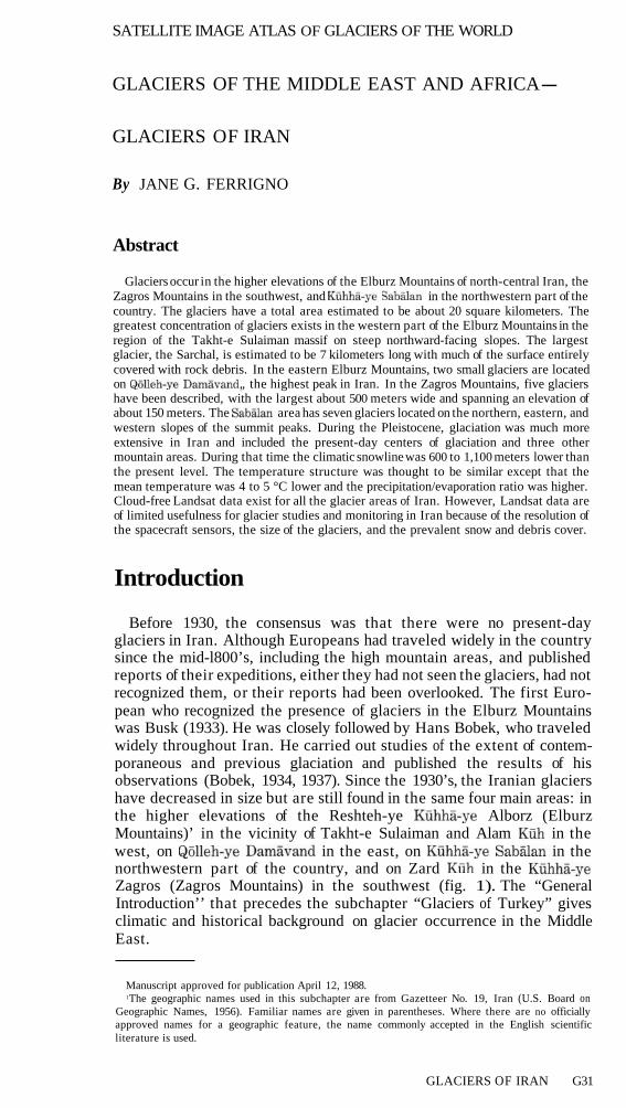
Glaciers occur in the higher elevations of the Elburz Mountains of north-central Iran, the Zagros Mountains in the southwest, and in the northwestern part of the country. The glaciers have a total area estimated to be about 20 square kilometers. The greatest concentration of glaciers exists in the western part of the Elburz Mountains in the region of the Takht-e Sulaiman massif on steep northward-facing slopes. The largest glacier, the Sarchal, is estimated to be 7 kilometers long with much of the surface entirely covered with rock debris. In the eastern Elburz Mountains, two small glaciers are located on , the highest peak in Iran. In the Zagros Mountains, five glaciers have been described, with the largest about 500 meters wide and spanning an elevation of about 150 meters. The area has seven glaciers located on the northern, eastern, and western slopes of the summit peaks. During the Pleistocene, glaciation was much more extensive in Iran and included the present-day centers of glaciation and three other mountain areas. During that time the climatic snowline was 600 to 1,100 meters lower than the present level. The temperature structure was thought to be similar except that the mean temperature was 4 to 5 °C lower and the precipitation/evaporation ratio was higher. Cloud-free Landsat data exist for all the glacier areas of Iran. However, Landsat data are of limited usefulness for glacier studies and monitoring in Iran because of the resolution of the spacecraft sensors, the size of the glaciers, and the prevalent snow and debris cover.
Introduction
Before 1930, the consensus was that there were no present-day glaciers in Iran. Although Europeans had traveled widely in the country since the mid-l800’s, including the high mountain areas, and published reports of their expeditions, either they had not seen the glaciers, had not recognized them, or their reports had been overlooked. The first Euro-pean who recognized the presence of glaciers in the Elburz Mountains was Busk (1933). He was closely followed by Hans Bobek, who traveled widely throughout Iran. He carried out studies of the extent of contem-poraneous and previous glaciation and published the results of his observations (Bobek, 1934, 1937). Since the 1930’s, the Iranian glaciers have decreased in size but are still found in the same four main areas: in the higher elevations of the Reshteh-ye Mountains)’ in the vicinity of Takht-e Sulaiman and Alam
Alborz (Elburz in the
west, on in the east, on in the northwestern part of the country, and on Zard in the Zagros (Zagros Mountains) in the southwest (fig. 1). The “General Introduction’’ that precedes the subchapter “Glaciers of Turkey” gives climatic and historical background on glacier occurrence in the Middle East.
Manuscript approved for publication April 12, 1988. 1The geographic names used in this subchapter are from Gazetteer No. 19, Iran (U.S. Board on
Geographic Names, 1956). Familiar names are given in parentheses. Where there are no officially approved names for a geographic feature, the name commonly accepted in the English scientific literature is used.
GLACIERS OF IRAN G31
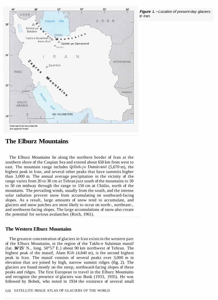
Figure 1.-Location of present-day glaciers in Iran.
The Elburz Mountains
The Elburz Mountains lie along the northern border of Iran at the southern shore of the Caspian Sea and extend about 650 km from west to east. The mountain range includes (5,670 m), the highest peak in Iran, and several other peaks that have summits higher than 3,000 m. The annual average precipitation in the vicinity of the range varies from 20 to 30 cm at Tehran just south of the mountains to 30 to 50 cm midway through the range to 150 cm at north of the mountains. The prevailing winds, usually from the south, and the intense solar radiation prevent snow from accumulating on southward-facing slopes. As a result, large amounts of snow tend to accumulate, and glaciers and snow patches are most likely to occur on north-, northeast-, and northwest-facing slopes. The large accumulations of snow also create the potential for serious avalanches (Roch, 1961).
The Western Elburz Mountains
The greatest concentration of glaciers in Iran exists in the western part of the Elburz Mountains, in the region of the Takht-e Sulaiman massif (lat. 36°25' N., long. 50°57' E.) about 90 km northwest of Tehran. The highest peak of the massif, Alam (4,840 m), is the second highest peak in Iran. The massif consists of several peaks over 3,000 m in elevation that are joined by high, narrow summit ridges (fig. 2). The glaciers are found mostly on the steep, northward-facing slopes of these peaks and ridges. The first European to travel in the Elburz Mountains and recognize the presence of glaciers was Busk (1933, 1935). He was followed by Bobek, who noted in 1934 the existence of several small
G32 SATELLITE IMAGE ATLAS OF GLACIERS OF THE WORLD
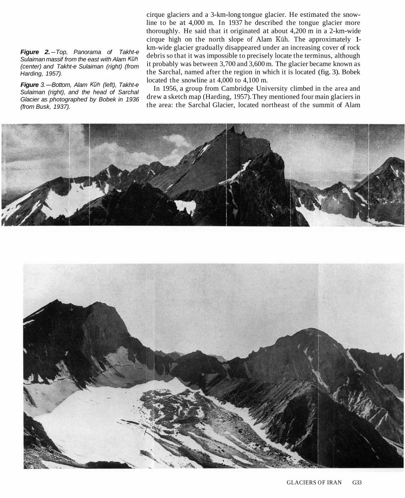
Figure 2.-Top, Panorama of Takht-e Sulaiman massif from the east with Alam (center) and Takht-e Sulaiman (right) (from Harding, 1957).
Figure 3.--Bottom, Alam (left), Takht-e Sulaiman (right), and the head of Sarchal Glacier as photographed by Bobek in 1936 (from Busk, 1937).
cirque glaciers and a 3-km-long tongue glacier. He estimated the snow-line to be at 4,000 m. In 1937 he described the tongue glacier more thoroughly. He said that it originated at about 4,200 m in a 2-km-wide cirque high on the north slope of Alam The approximately 1-km-wide glacier gradually disappeared under an increasing cover of rock debris so that it was impossible to precisely locate the terminus, although it probably was between 3,700 and 3,600 m. The glacier became known as the Sarchal, named after the region in which it is located (fig. 3). Bobek located the snowline at 4,000 to 4,100 m.
In 1956, a group from Cambridge University climbed in the area and drew a sketch map (Harding, 1957). They mentioned four main glaciers in the area: the Sarchal Glacier, located northeast of the summit of Alam
GLACIERS OF IRAN G33

, a northwest glacier, and two glaciers to the south of the summit, the Hazarchal and the Hazarcham (fig. 4). They also noted two small, unnamed glaciers. The sketch map produced by Harding and those made by earlier travelers (Busk, 1935) were the only available maps of the area until 1957, when Bobek produced an excellent map a t 1:100,000 scale of the Takht-e Sulaiman region (Bobek, 1957). I t remains the only map of Iran that shows the occurrence of glaciers.
In 1958, Péguy, a member of a French expedition in Iran, described and sketched the glaciers in the vicinity of Alam although he concentrated on the Sarchal Glacier (fig. 5) (Péguy, 1959). He described the Sarchal as forming from the confluence of three unequal segments. He estimated its length a t 7 km with two-thirds of the surface entirely covered with rock debris. In describing its motion, he said that the eastern third consisted of active ice bounded by an active lateral moraine and covered by debris 0.5 to 1.5m thick. The other two-thirds was mostly
Figure 4.-The glaciers in the Takht-e Sulaiman massif region (from Harding, 1957).
G34 SATELLITE IMAGE ATLAS O F GLACIERS OF THE WORLD

Figure 5.-Sarchal Glacier, Takht-e Sulai-man massif (from Péguy, 1959).
inactive ice covered with several meters of inert cover. The most recent data for the area (Schweizer, 1972) locate the snowline at 4,150 m. This estimate is based on the work of Bout and others (1961).
The Eastern Elburz Mountains
At present all of the glaciers in the eastern Elburz are located on
dormant stratovolcano, is located about 70 km northeast of Tehran. Because it is the highest peak in Iran and because it is not difficult to reach from the south, it has been climbed repeatedly. Notes of a visit by Watson in 1861 described a summit covered by snow and sulfur (Watson, 1862). He found places where there were sulfur fumes and the ground was too hot to sit on for more than a few minutes. It was not until Bobek’s visit with the German climbing expedition of 1936, however, that the glaciers were mentioned (Bobek, 1937). He described the peak as almost entirely covered by firn above 4,500 m. The firn was continuous in the highest regions and separated into deeply eroded bands of snow and ice farther down. He recognized two small glaciers, one on the east slope, the other on the north slope (fig. 6). The eastern glacier descended from the peak to the steep, fragmented cliff walls at the head of the Talu Valley
GLACIERS O F IRAN G35

Figure 6. -The (from Bobek, 1937).
glaciers on
at about 4,800 to 5,000 m elevation. Here the glacier broke off cleanly, and the thickness was seen to be about 50 m. Glacier ice accumulated at the foot of the cliffs at about 3,900 m in ice debris cones and extended downward to about 3,400 m. The glacier on the northern slope started 600 t o 800 m below the summit, extending downslope to about 4,400 m. At the lower elevations the glacier was broken and fragmented. Bobek placed the snowline at 4,500 m.
In September 1958, Péguy climbed the volcano with the French group and described the summit region (Péguy, 1959). He described a north-eastern glacier (probably Bobek’s eastern glacier) having a surface area of about 2 km². It formed a little below the summit at about 5,550 to 5,600 m and ended at about 5,100 m. The glacier was covered with large penitentes and a series of crevasses. There was not much debris cover. Penitentes, an annual phenomenon of snow sublimation related to solar radiation and arid climate, occur only on selected peaks in the region; they do not occur on similar peaks in nearby Turkey. Although penitentes form on the highest peaks in Alum and climate is more important than elevation to their formation. The inci-dence angle of the Sun, the intensity of the radiation, and the dryness of the air in late summer and early fall, the time of maximum development, determine the occurrence, size, and shape of the penitentes (Schweizer, 1972). In addition, Péguy noted the southern side of the summit crater was covered by ice. Here and on the southern slope of the volcanic cone
G36 SATELLITE IMAGE ATLAS OF GLACIERS OF THE WORLD

were penitentes 50 to 80 cm or more in height. The most recent data on the area are given by Schweizer (1972). He described the southern slope above 4,800 m and the summit crater of Damiivand as covered with firn and penitentes (fig. 7).
South of Damiivand a small glacier referred to as a “tonsurgletscher” was observed on Tare Mumedsch a t 3,035 m in September 1936 (Hey-brock, 1940). However, no mention of the glacier has been made since that time, and it has most likely disappeared.
Figure 7.- of
1972).
Penitentes in the summit crater
tember 1968; from Schweizer,
The area (lat. 38°15’ N., long. 47°49’ E.) has a continental climate with hot, dry summers and extremely cold, snowy winters (Schweizer, 1970). Although there are no meteorological stations on the mountain itself, Schweizer was able to estimate the annual precipitation to be between 400 and 700 mm, on the basis of the elevation of the mountain and extrapolation of data from surrounding stations. The precipitation, which falls almost exclusively as snow in the late autumn, winter, and spring, nourishes the glaciers on the highest peaks. During the arid summer, there is considerable ablation, however.
The presence of glaciers on (4,740 m) was first recognized in 1885 by Sjögren (1888), who described a small cirque glacier that was about 1 km long, 0.33 km wide, and descended to about 3,800 m. However, his report was not widely known. In 1934, Bobek observed the glaciers from a distance and estimated the snowline to be between 3,900 and 4,000 m (Bobek, 1934). A few years later, Bobek (1937) listed the height of the snowline on the north side of as 4,000 to 4,100 m.
In September 1955, a German mountain climbing group climbed the peak and photographed and described the glaciers (Klebelsberg, 1958). On the northwest slope, there were large, interconnected glaciers extending from the summit downward to 4,000 m. On the south to southwestern sides there were only limited snow fields.
In 1968 and 1969, Schweizer carried out extensive fieldwork in the area (Schweizer, 1970, 1972). His description of the glaciers is very detailed,
GLACIERS OF IRAN G37
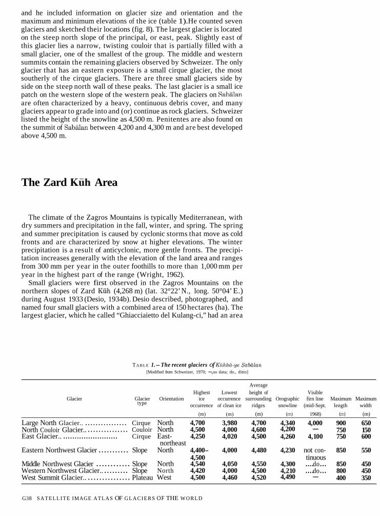
and he included information on glacier size and orientation and the maximum and minimum elevations of the ice (table 1).He counted seven glaciers and sketched their locations (fig. 8). The largest glacier is located on the steep north slope of the principal, or east, peak. Slightly east of this glacier lies a narrow, twisting couloir that is partially filled with a small glacier, one of the smallest of the group. The middle and western summits contain the remaining glaciers observed by Schweizer. The only glacier that has an eastern exposure is a small cirque glacier, the most southerly of the cirque glaciers. There are three small glaciers side by side on the steep north wall of these peaks. The last glacier is a small ice patch on the western slope of the western peak. The glaciers on are often characterized by a heavy, continuous debris cover, and many glaciers appear to grade into and (or) continue as rock glaciers. Schweizer listed the height of the snowline as 4,500 m. Penitentes are also found on the summit of between 4,200 and 4,300 m and are best developed above 4,500 m.
The Zard Area
The climate of the Zagros Mountains is typically Mediterranean, with dry summers and precipitation in the fall, winter, and spring. The spring and summer precipitation is caused by cyclonic storms that move as cold fronts and are characterized by snow at higher elevations. The winter precipitation is a result of anticyclonic, more gentle fronts. The precipi-tation increases generally with the elevation of the land area and ranges from 300 mm per year in the outer foothills to more than 1,000 mm per year in the highest part of the range (Wright, 1962).
Small glaciers were first observed in the Zagros Mountains on the northern slopes of Zard (4,268 m) (lat. 32°22’ N., long. 50°04’ E.) during August 1933 (Desio, 1934b). Desio described, photographed, and named four small glaciers with a combined area of 150 hectares (ha). The largest glacier, which he called “Ghiacciaietto del Kulang-ci,” had an area
TABLE 1.-The recent glaciers of [Modified from Schweizer, 1970; -,no data; do., ditto]
Average Highest Lowest height of Visible
Glacier Glacier Orientation ice occurrence surrounding Orographic firn line Maximum Maximum type occurrence of clean ice ridges snowline (mid-Sept. length width
(m) (m) (m) (m) 1968) (m) (m)
Large North Glacier.. ................ Cirque North 4,700 3,980 4,700 4,340 4,000 900 650 North Couloir Glacier.. ............... Couloir North 4,500 4,000 4,600 4,200 - 750 150 East Glacier.. ........................ Cirque East- 4,250 4,020 4,500 4,260 4,100 750 600
northeast Eastern Northwest Glacier ........... Slope North 4,400- 4,000 4,480 4,230 not con- 850 550
4,500 tinuous Middle Northwest Glacier ............ Slope North 4,540 4,050 4,550 4,300 ....do... 850 450 Western Northwest Glacier.. ......... Slope North 4,420 4,000 4,500 4,210 ....do... 800 450 West Summit Glacier.. ............... Plateau West 4,500 4,460 4,520 4,490 - 400 350
G38 SATELLITE IMAGE ATLAS OF G L A C I E R S OF THE WORLD

Figure 8.-The occurrence of glaciers on (modified from Sch weizer, 1972).
of 70.4 ha. Each glacier occupied a span of about 200 m elevation, with the minimum occurring at about 3,600 m and the maximum at 4,200 m. In 1937, Bobek listed the snowline at 4,000 to 4,100 m. In 1963, Dr. H. McQuillan (1969) photographed the “Ghiacciaietto” (fig. 9). He estimated its width at 400 m. Comparison of his photograph with Desio’s sketch shows that the glacier had thinned considerably and that the toe had receded at least 20 m of the total 100 m elevation it spanned.
In 1972, Schweizer used the work of others and his own analysis of aerial photographs to estimate the height of the snowline at Zard at 4,050 m. In 1975, Grunert and others (1978) studied the glaciers, firn patches, snowline, and climate of the Zard area. They described and
GLACIERS OF IRAN G39
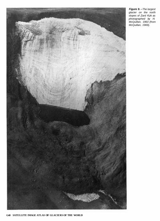
Figure 9.-The largest glacier on the north slopes of Zard as photographed by H. McQuillan, 1963 (from McQuillan, 1969).
G40 SATELLITE IMAGE ATLAS OF GLACIERS OF THE WORLD

1978).ified from Grunert and others,
sketched the location of five glaciers (fig. 10). The largest was described as 500 m wide and spanned an elevation of 150 m from 3,900 t o 4,050 m. On the basis of the location and condition of the glaciers and firn patches, they concluded the snowline had dropped to 3,900 m. They noted that the Zagros Mountains contain glaciers, while equally high mountains to the east do not because of the weather pattern. Other areas eastward fall within the precipitation shadow of the Zagros Mountains and are much more arid.
Glacier Fluctuation
During the Pleistocene, there were six centers of glaciation in Iran, according t o Bobek (1963), including the central Elburz Mountains,
Zard and three other mountain areas. The most important single area was the Takht-e Sulaiman massif of the central Elburz. Here the Sarchal Glacier, currently the largest in Iran at about 7 km, extended between 20 and 25 km. Two other glaciers, one 13 km and the other 11 km long, also were present. Bobek (1963) also maintained that during the Pleistocene the climatic snowline throughout the country was 600 t o 800 m lower than the present level and that the temperature structure was similar to current patterns except that the mean temper-ature was 4 to 5° C lower. On the basis of a study of the playas, Krinsley concluded that, during the Würm maximum, the outward-facing slopes of the northern Zagros and Elburz Mountains had mean annual tempera-tures 5 to 8° C colder than at present. The snowline was depressed as much as 1,800 m (Krinsley, 1970). Krinsley also (1968) added that the Pleistocene climate of Iran was more compartmented than in other
GLACIERS OF IRAN G41

countries in similar latitudes. He stated that, although the Pleistocene climate of northern Iran was similar t o the present climate, the precipi-tation/evaporation ratio was higher because of decreased evaporation resulting from lower summer temperatures (Krinsley, 1972). Schweizer (1970) compared Pleistocene and present snowlines on the basis of his own and earlier studies (table 2). Since the end of the Pleistocene, there is evidence of a series of stadia1 retreats and readvances of the glaciers as the climate cycle progressed. The cool, dry climate of the Pleistocene gave way to a warm, dry climate, and the level of precipitation increased slowly during the Hypsithermal until about 5,500 years ago (Wright, 1968). This period was followed by the colder temperatures of the Neoglacial. Minor temperature fluctuations occurred until the generally cooler times of the “Little Ice Age” of the 16th and 18th centuries. Since the 19th century the glaciers of Iran have probably followed the same general pattern as described for Turkey by Erinç (1952). He stated the trend has been toward general recession interrupted by periods of growth. Since 1930, the rate of recession has accelerated. The contem-porary glaciers, however, are not relict but have regenerated in post-Pleistocene times and at one time covered an area twice their present size.
Information on the total areal coverage of glaciers in Iran is nonexist-ent. Previous reviews of Iran’s glaciers have discussed occurrence, but not areal extent (Klebelsberg, 1949; McCauley, 1958; Horvath, 1975). Drygalski and Machatschek (1942) estimated the total glacier area of Turkey, Armenia, and Iran to be about 100 km². Recent estimates by Kurter for the total glacier area of Turkey, included elsewhere in this chapter, are 22.9 km². A very rough estimate for the current size of Iran’s glaciers is 20 km². This estimate is based on estimates of 14 km² for the glaciers of -
for Zard
the Takht e Sulaiman massif made from sketch maps listed on
(Schweizer, 1970), and 1.5 km² (Desio, 1934b).
TABLE 2. -The height of the present and Pleistocene snowlines in selected mountain areas of Iran
[Modified from Schweizer, 1970]
Summit Present PleistoceneMountain area Source
height snowline snowline (m) (m) (m)
Takht-e Sulaiman ...... 4,840 4,0004,100 3,000 Bobek, 1937; Bout and others, 1961.
............. 5,670 4,500 3,700-3,800 Bobek, 1937; Bout and others, 1961.
................ 4,740 4,500 3,6004,700 Schweizer, 1970. Zard .............. 4,268 3,900 3,3504,400 Desio 1934a; Grunert
and others, 1978.
Available Data for Glacier Studies
Maps
There are a very limited number of maps available for glacier studies of Iran. The first maps available were the sketch maps produced by early travelers and climbers. Later researchers also produced sketch maps because of the absence of accurate maps showing glacier occurrence. The only published map that shows the occurrence of glaciers is a map by Bobek at a scale of 1:100,000 of the Takht-e Sulaiman massif area, published in 1957. Later maps, which have been produced at various
G42 SATELLITE IMAGE ATLAS OF GLACIERS OF THE WORLD

scales, do not show the glaciers but depict the topography of each of the glacier areas. Information about the available maps is given in table 3.
TABLE 3. -List of maps covering the glacier areas of Iran
Map or author Scale Glacier areas covered
Published maps and charts U.S. Defense Mapping Agency- 1: 1,000,000 All areas Operational Navigation Chart
ONC G-5 U.S. Defense Mapping Agency- 1:250,000 Joint Operations Graphic, Series 1501
Sheet NJ 39-14, 15 Takht-e Sulaiman Sheet NI 39-3 Sheet NJ 38-8 Sheet NI 39-14 Zard
Kartog Anstalt Freytag-Berndt und 1:100,000 Takht-e Sulaiman Artaria, Vienna-Karte der Takht-e Sulaimangruppe in mittleren Alburzgebirge, Nordiran Geological Survey of Iran- 1:100,000 Geological Map of the Central Alborz
Sheet Sketch maps
Busk, 1935 ~1:90,000 Takht-e Sulaiman Harding, 1957 ~1:90,000 Takht-e Sulaiman Péguy, 1959 ~ 1:50,000 Takht-e Sulaiman
Zard
Bobek, 1937 ~ 1:300,000 Schweizer, 1972 ~1:70,000 Grunert and others, 1978 ~1:90,000
Aerial Photographs
Some aerial photographs were acquired by the U.S. Air Force for the U.S. Army Map Service in the late summer and fall of 1955 and 1956 and the summer of 1970. The photographs are valuable for getting an
glacier areas are listed in table 4. The photograph taken of August 1955 is particularly good (fig. 11). It was taken a t a time of minimum snow cover, and the two glaciers described by Bobek are clearly visible.
of ataccurate view the glaciers that time. The photographs that cover the
TABLE 4.-Aerial photographic coverage of the glacierized areas of Iran
Date Project Sortie Frame Approximate scale
Takht-e Sulaiman area 03 Oct 55 ................. 158 M99 15938-15940 1:60,000 03 Oct 55. ................ 158 S99 15937A-15940 1:30,000 03 Oct 55 ................. 158 S99 15904-15909 1:30,000
area 13 Sept 56 ................ 158 M231 33578 1:45,000 01 Aug 55.. ............... 157 LS23A 3736-3736A 1:30,000
area 08 Jun 70. . ............... NW-IRAN R25 1553-1555 1:60,000
Zard 31 Aug 55.. ............... 158 R64A 10774A-10775 1:30,000 31 Aug 55.. ............... 158 R64 10773-10775 1:60,000 29 Aug 55.. ............... 158 R59A 9861A-9862A 1:30,000 29 Aug 55 ................. 158 59 9951-9953, 9961-9963 1:50,000
GLACIERS OF IRAN G43

Figure 11.-Aerial photograph of the gla-ciers on acquired in August 1955 by the U.S. Air Force for the Army Map Service, Project 157, Frame 3736A. Approx-imate scale 1:30,000.
G44 SATELLITE IMAGE ATLAS OF GLACIERS OF THE WORLD
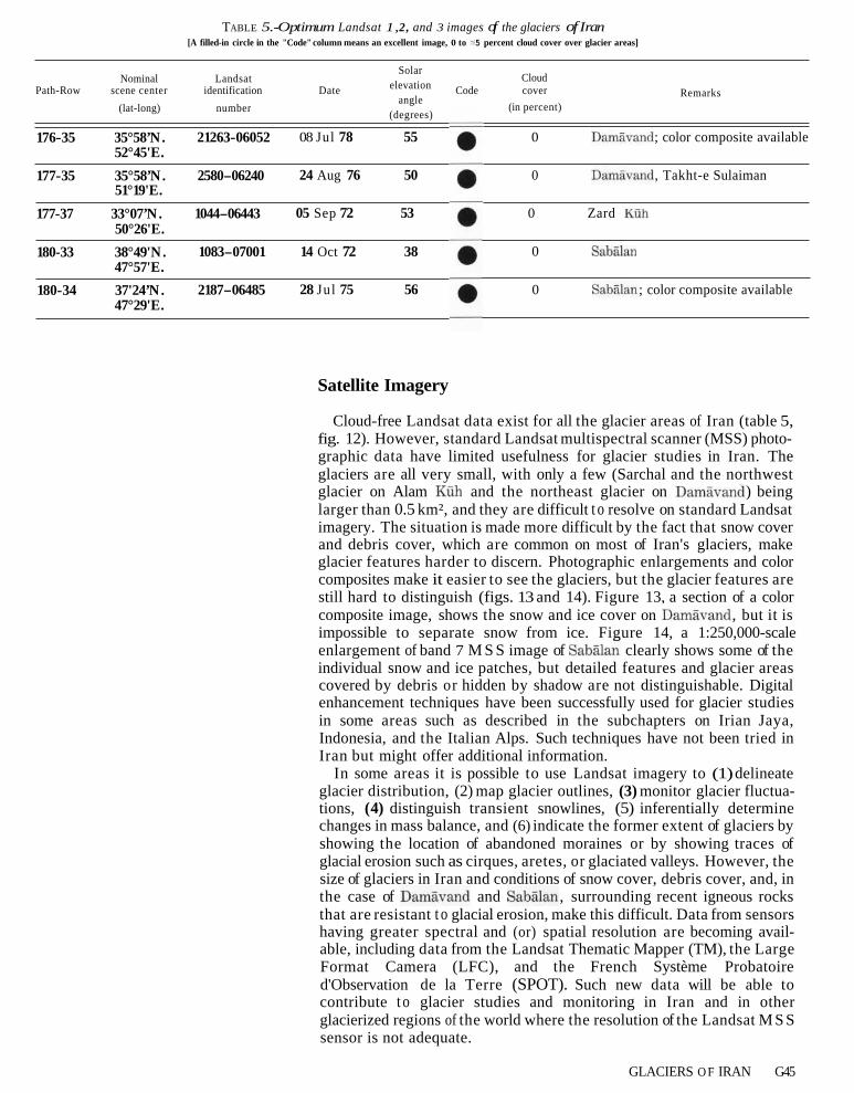
TABLE 5.-Optimum Landsat 1,2, and 3 images of the glaciers of Iran [A filled-in circle in the "Code" column means an excellent image, 0 to 5 percent cloud cover over glacier areas]
SolarNominal Landsat Cloud
Path-Row scene center identification Date elevation Code cover Remarksangle
(in percent) (lat-long) number (degrees)
176-35 35°58’N. 21263-06052 08 Jul 78 55 0 ; color composite available 52°45'E.
177-35 35°58’N. 2580-06240 24 Aug 76 50 0 , Takht-e Sulaiman 51°19'E.
177-37 33°07’N. 1044-06443 05 Sep 72 53 0 Zard 50°26'E.
180-33 38°49'N. 1083-07001 14 Oct 72 38 0 47°57'E.
180-34 37'24’N. 2187-06485 28 Jul 75 56 0 ; color composite available 47°29'E.
Satellite Imagery
Cloud-free Landsat data exist for all the glacier areas of Iran (table 5, fig. 12). However, standard Landsat multispectral scanner (MSS) photo-graphic data have limited usefulness for glacier studies in Iran. The
glacier on Alam glaciers are all very small, with only a few (Sarchal and the northwest
and the northeast glacier on ) being larger than 0.5 km², and they are difficult t o resolve on standard Landsat imagery. The situation is made more difficult by the fact that snow cover and debris cover, which are common on most of Iran's glaciers, make glacier features harder to discern. Photographic enlargements and color composites make it easier to see the glaciers, but the glacier features are still hard to distinguish (figs. 13 and 14). Figure 13, a section of a color composite image, shows the snow and ice cover on , but it is impossible to separate snow from ice. Figure 14, a 1:250,000-scale enlargement of band 7 M S S image of clearly shows some of the individual snow and ice patches, but detailed features and glacier areas covered by debris or hidden by shadow are not distinguishable. Digital enhancement techniques have been successfully used for glacier studies in some areas such as described in the subchapters on Irian Jaya, Indonesia, and the Italian Alps. Such techniques have not been tried in Iran but might offer additional information.
In some areas it is possible to use Landsat imagery to (1) delineate glacier distribution, (2) map glacier outlines, (3) monitor glacier fluctua-tions, (4) distinguish transient snowlines, (5) inferentially determine changes in mass balance, and (6) indicate the former extent of glaciers by showing the location of abandoned moraines or by showing traces of glacial erosion such as cirques, aretes, or glaciated valleys. However, the size of glaciers in Iran and conditions of snow cover, debris cover, and, in the case of and , surrounding recent igneous rocks that are resistant t o glacial erosion, make this difficult. Data from sensors having greater spectral and (or) spatial resolution are becoming avail-able, including data from the Landsat Thematic Mapper (TM), the Large Format Camera (LFC), and the French Système Probatoire d'Observation de la Terre (SPOT). Such new data will be able to contribute t o glacier studies and monitoring in Iran and in other glacierized regions of the world where the resolution of the Landsat M S S sensor is not adequate.
GLACIERS O F IRAN G45

Figure 12.-Optimum Landsat 1 , 2, and 3 images of the glaciers of Iran. The vertical lines represent nominal paths. The rows (horizontal lines) have been established to indicate the latitude at which the imagery has been acquired.
G46 SATELLITE IMAGE ATLAS OF GLACIERS OF THE WORLD

------
------
--------
Acknowledgment The author wishes t o thank N. Tamberg for assistance
in translating some of the German references.
References Cited Bobek, H., 1934, Reise in Nordwestpersien 1934 [Travel in northwest
Persia 19341: Zeitschrift der Gesellschaft für Erdkunde zu Berlin, V. 9/10, p. 359-369.
1937, Die Rolle der Eiszeit in Nordwestiran [The role of the ice age in northwestern Iran]: Zeitschrift für Gletscherkunde, v. 25, p. 130-183.
1957, Die Takht-e im mittleren Alburzege-birge, Nordiran, in Wiche, K., ed., Festschrift zur Hundertjahr-feier der Geographischen Gesellschaft in Wien 1856-1956 [Anni-versary Publication for the Centennial of the Geographical Society of Vienna 1856-1956]: Geographische Gesellschaft Vienna, p. 236-264.
1963, Nature and implications of Quaternary Climatic changes in Iran, in Changes of climate, Proceedings of Symposium on Changes of Climate with Special Reference to And Zones: Rome, 1961, UNESCO, p. 403413.
Bout, P . , Derruau, M., Dresch, J . and Péguy, Ch.P., 1961, Observa-tions de geographie physique en Iran septentrional. Expedition 1958 SOUS les auspices du C.N.R.S. [Observations on the physical geography of northern Iran. Expedition of 1958 under the auspices of C.N.R.S.]: Memoires et Documents 8, Paris, p. 9-112.
Busk, D.L., 1933, Climbing and ski-ing in the Elburz Range, North Persia, 1931-2: Alpine Journal, v. 45, no. 247, p. 334-341.
1935, Climbing in the Takht-i-Suleiman Group, N. Persia: Alpine Journal, v. 47, no. 251, p. 299-309.
1937, The German expedition in the Elburz Range, N. Persia: Alpine Journal, v. 49, no. 255, p. 245-247.
Desio, A . , 1934a, Appunti geografici e geologici sulla catena dello Zardeh Kuh in Persia [Geographic and geologic information con-cerning the Zard mountains in Persia]: Memorie Geologiche e Geographiche di G. Dainelli, 4, p. 141-167.
1934b, Sull'esistenza di piccoli ghiacciai nella Persia occidentale [Concerning the existence of small glaciers in western Persia]: Bollettino del Comitato Glaciologico Italianao, no. 14, p. 39-52.
Drygalski, E. von, and Machatschek, F., 1942, Enzyklopädie der Erdkunde: Gletscherkunde [Encyclopedia of Earth Sciences: Gla-ciology]: Wien, Franz Deuticke, 261 p.
Erinç, S.,1952, Glacial evidences of the climatic variations in Turkey: Geografiska Annaler, v. 34, no. 1-2, p. 89-98.
Grunert, J., Carls, H.-G., and Preu, C., 1978, Rezente Ver-gletscherungsspuren in zentraliranischen Hochgebirgen [The present-day glaciers of the central Iranian high mountains]: Eiszeitalter und Gegenwart, v. 28, p. 148-166.
Harding, J.G.R., 1957, Cambridge Expedition, 1956, to the Elburz Mountains, Iran: Himalayan Journal, v. 20, p. 112-121.
Figure 13.-Left, Section of a 1:1,000,000-scale Landsat 2 MSS color-composite image 27263-6052 (Path 176, Row 35, acquired 8
Figure 14. -Right, A 1:250,000-scale enlarge-ment of a section of Landsat MSS image 2187-06485 (band 7; Path 180, Row 34, acquired 28 July 1975) showing some of the glaciers and snow patches on
Heybrock, W., 1940, Naturwissenschaftliche Beobachtungen in Iran: Petermanns Geographische Mitteilungen 86, no. 4, p. 124-131.
Horvath, E., 1975, Glaciers of Turkey, Armenian S.S.R. and Iran, in Field, W.O., ed., Mountain glaciers of the Northern Hemisphere, pt. 111, Glaciers of Southern Asia: Hanover, N.H., U.S. Army Cold Regions Research and Engineering Laboratory, p. 343-359.
Klebelsberg, R. von, 1949, Handbuch der Gletscherkunde und Glazial-geologie [Handbook of glaciology and glacial geology]: Wien, Springer-Verlag, 1028 p.
1958, Von der Vergletscherung des Kuh-i-Sawalan (4,821 m),
northwest Persia]: Zeitschrift für Gletscherkunde und Glazialge-ologie, v. 4, no. 1-2, p. 119-120.
Krinsley, D.B., 1968, Geomorphology of three kavirs in northern Iran, in Neal, J.T., ed., Playa surface morphology: Miscellaneous inves-tigations, chap. 5: Air Force Cambridge Research Laboratory, Environmental Research Papers, no. 283, p. 105-130.
1970, A geomorphological and paleoclimatological study of the playas of Iran: U.S. Geological Survey Interagency Report IR-Military-1, 329 p.
1972, The paleoclimatic significance of the Iranian playas, in Zinderen Bakker, E.M. van, ed., Palaeoecology of Africa, v. 6: Cape Town, A.A. Balkema, p. 114-120.
McCauley, C., 1958, Glaciers of Turkey, Iran, and Soviet Armenia, in Glaciation in the Northern Hemisphere, pt. 6, Western, arctic, and eastern Asia: New York, American Geographical Society, p. 6.1.1-6.1.4.
McQuillan, H., 1969, Small glacier on Zardeh Kuh, Zagros Mountains, Iran: Geographical Journal, v. 135, pt. 4, p. 639.
Péguy, Ch.P., 1959, Les glaciers de l'Elbourz [The glaciers of the Elburz Mountains]: Bulletin de I'Association de Géographes Français, no. 284-285, p. 44-49.
Roch, A., 1961, Avalanche danger in Iran: Journal of Glaciology, v. 3, no. 30, p. 979-983.
Schweizer, G., 1970, Der Kuh-e-Sabalan (Nordwestiran). Beiträge zur Gletscherkunde und Glazialgeomorphologie vorderasiatischer Hochgebirge (northwest Iran). Contributions on the glaciology and glacialgeomorphology of the high mountains of the Near East], in Beitrage zur Geographie der Tropen und Subtropen: Tübinger Geographische Studien, no. 34, p. 163-178.
1972, Klimatisch bedingte Geomorphologische und Glazialo-gische Züge der Hochregion vorderasiatischer Gebirge (Iran und Ostanatolien) [Climatically based geomorphological and glaciolog-ical characteristics of the high-altitude regions of Near Eastern mountains (Iran and Eastern Anatolia)]: Erdwissenschaftliche Forschung, v. 4, p. 221-236.
Sjögren, H., 1888, Beiträge zur Geologie des Berges SaveIan in nordlichen Persien [Contributions to the geology of the Mountains in northern Persia]: Verhandlungen der Russisch-Kaiserlichen Mineralogischen Gesellschaft zu St. Petersberg, Series 2, v. 24, p. 36-66.
U. S. Board on Geographic Names, 1956, Gazetteer No. 19, Iran: Washington, D.C., U.S. Government Printing Office.
Watson, R.G., 1862, Notes of a visit to the Elburz Mountains and ascent of Demavend: Royal Geographic Society Proceedings, v. 6, p. 103-105.
Wright, H.E., Jr., 1962, Pleistocene glaciation in Kurdistan: Eiszeit-alter und Gegenwart, v. 12, p. 131-164.
1968, Climatic change in the Eastern Mediterranean region: Limnological Research Center, University of Minnesota, Minne-apolis, 15p.
GLACIERS OF IRAN G47