glacial history and ice flow dynamics applied to drift ... · drift prospecting and geochemical...
TRANSCRIPT

Exploration
Geochemistry
GOT
Author Index
Section Contents
Explor97 Master Page
Explor97 Contents
O Next PaperPrevious PaperPaper 30
Glacial History and Ice Flow Dynamics Applied to
Drift Prospecting and Geochemical Exploration
Klassen, R.A.[1]
1. Geological Survey of Canada, Ottawa, Ontario, Canada
drift prospecting, Laurentide Ice Sheet, till, glacial dispersal
ABSTRACT
Mineral exploration by drift prospecting has long relied on glacial dispersal models to trace indicator erratics in glacialdeposits and locate their bedrock source. In the past decade, advances in the fields of glaciology and glacial sedimentologyhave lead to more sophisticated interpretations of the Quaternary geological record in terms of glacial process, glacial sed-iment provenance, and glacial history. At the same time, models of the Laurentide Ice Sheet, and its adjacent glacier com-plexes, have included geological and physical properties of the ice bed, thereby providing more accurate portrayals of spatialand temporal variations in regional ice flow dynamics. Those models show that ice divides were long-standing, dynamicfeatures of the ice sheet, affecting drift composition over large areas of glaciated terrain, and have indicated that ice streamsserved as important agents of erosion, transport, and deposition. Their accuracy has been refined by the empirical evidenceof drift composition and ice flow history resulting from ongoing regional surveys of drift composition. Together, the empir-ical and theoretical models provide a regional framework for developing mineral exploration strategies in terms of glacialprocess and its effects on drift composition. For example, an exponential decrease in indicator concentrations with distanceof glacial transport reflects glacial transport and abrasion as part of the basal debris load, whereas linear to no decreasereflects englacial transport with minimal to no deposition during transport. Linear profiles may be characteristic of icestreams. The linkages among distance and direction of glacial transport, glacial history, and ice sheet dynamics have thusenhanced the value of glacial dispersal models as predictive tools for exploration.
INTRODUCTION
Drift prospecting is based on the simple premise that indicators of eco-nomic mineralization in glacial deposits—lithological, mineralogical,or geochemical—can be traced to their bedrock source. In practice, itsapplication to mineral exploration is seldom straightforward, reflectingthe complex processes of glacial erosion, transport, and deposition thatact to form glacial deposits, and their heterogeneous character. Despitethose complications, drift prospecting has long been an integral part ofmineral exploration in glaciated terrain, especially in Fennoscandiawhere many of the techniques of boulder tracing and geochemistry wereoriginally developed and applied. There, a logistic infrastructure has longfacilitated surficial geological and geochemical mapping, and Quaternarygeology has been well supported by governments, universities, and theexploration industry itself. In contrast, the large size and remote setting ofCanada have lead to greater emphasis on theoretical models of glacialdispersal as predictive tools in mineral exploration (e.g., Shilts, 1993).
Over the past decade the basis for drift prospecting in Canada hasbeen significantly improved by developments related to theoreticalmodels of the ice sheet and ice flow dynamics, to mechanisms of glacialerosion, transport, and deposition, and to mapping of glacial deposits
and drift composition. Theoretical models have begun to accommodatediverse glaciologic, physiographic, and geological factors that can affectice flow, and have been used to reinterpret the geological record in termsof glacial processes. At the same time, regional studies of glacial historyand drift composition by provincial and federal Geological Surveys havebeen carried out in large parts of Canada, representing an unprece-dented increase in our knowledge of drift composition. Through thatwork, tens of thousands of geochemical, mineralogical, and lithologicaltill analyses have been reported, allowing glacial dispersal trains to bemodelled in terms of distance and direction of glacial transport, glaciallandform association, and geographic and glaciological context in theice. Because those advances have occurred in diverse fields of Quater-nary geology, including glaciology, glacial sedimentology and stratigra-phy, paleoclimatology, and environmental study, their significance toexploration is not widely recognized. As a further complication, theglacial system is described at scales from continental (thousands of kilo-metres), to regional (hundreds of kilometres), local (kilometres to tensof kilometres), to detailed (hundreds of metres to kilometres) (Shilts,1984; Clark, 1987), but the focus of mineral exploration typicallyremains either local or detailed, driven by an immediate need to locate abedrock source of an indicator erratic. The parallel developments in
In “Proceedings of Exploration 97: Fourth Decennial International Conference on Mineral Exploration” edited by A.G. Gubins, 1997, p. 221–232
222 Exploration Geochemistry
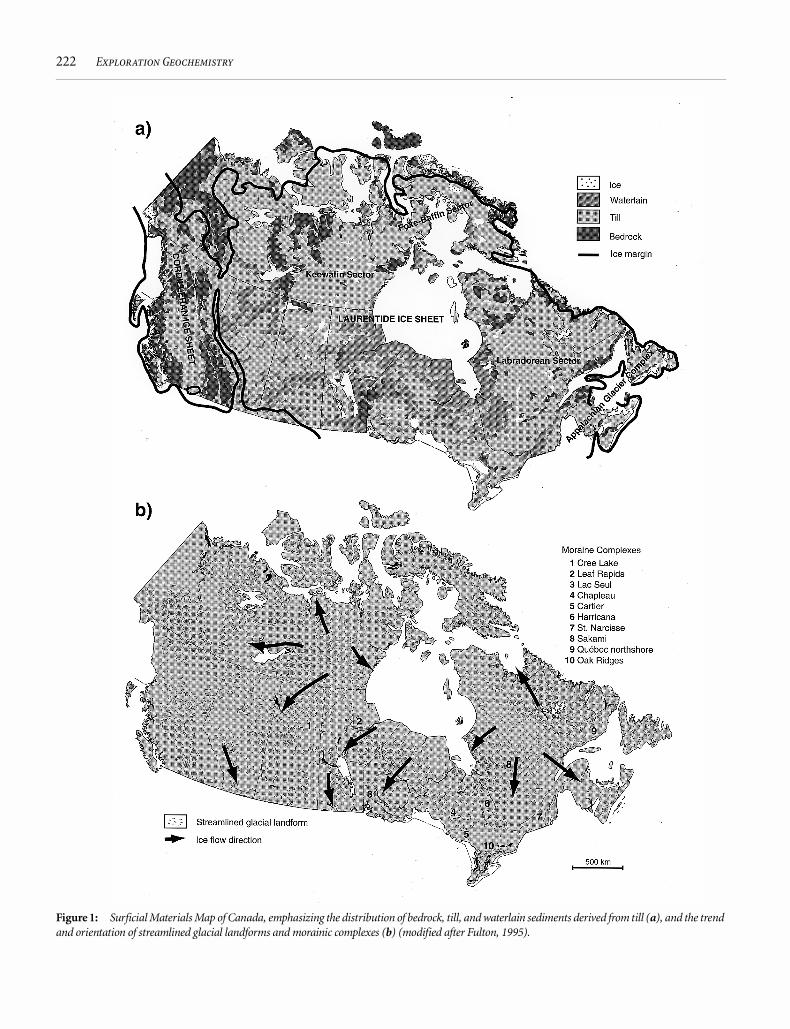
Figure 1: Surficial Materials Map of Canada, emphasizing the distribution of bedrock, till, and waterlain sediments derived from till (a), and the trendand orientation of streamlined glacial landforms and morainic complexes (b) (modified after Fulton, 1995).

Klassen, R.A. GLACIAL HISTORY AND ICE FLOW DYNAMICS 223
Quaternary geology and ice sheet modelling have provided an importantnew set of tools for tailoring drift prospecting methods to suit regionalvariations in ice flow dynamics and glacial dispersal.
Through a selective overview, this paper links recent advances inQuaternary geology to drift prospecting in a broad perspective. Unlikea case history approach, which emphasizes current methods and explo-ration successes, this paper illustrates the diverse approaches available tothe exploration community for the effective use of glacial deposits inexploration. Neither text nor references are intended to be comprehen-sive, but rather to serve as guides for further investigation; the results ofnumerous deserving studies have been omitted for lack of space.Although the focus is on Canada, and the area covered by the LaurentideIce Sheet in particular, Fennoscandian research on glacial process anddrift composition has direct application to Canadian exploration prac-tice and as such is extensively reported.
ICE SHEET MODELLING
At all scales, the provenance and composition of glacial deposits reflectsglacial history and ice flow dynamics. Thus, ice sheet models are impor-tant to mineral exploration because they can be used to illustrateregional variations in distances and directions of glacial transport, andin the relationship between bedrock and drift composition in terms ofglacial process. During the last glaciation, the Wisconsin, the glaciercomplex that blanketed Canada and the northern United States com-prised four distinct components, including the Laurentide Ice Sheet,which covered most of the interior plains and Shield regions, the Cordil-leran Ice Sheet over the western mountains, the Appalachian GlacierComplex over the maritime provinces, and the Queen Elizabeth IslandsGlacier Complex over the Arctic archipelago (Figure 1a). The LaurentideIce Sheet, by far the largest component, has been further subdivided intothe Keewatin, Labradorean, and Foxe-Baffin sectors. Although coalescent,the sectors were dominated by semi-independent ice divides that changedin size, shape, and extent during glaciation (Dyke and Prest, 1987).
Models of the Laurentide Ice Sheet are continually modified byacquisition of geological data such as striations, indicator erratics, andstratigraphy that are used to constrain the extent of ice and the trend andsequence of ice flow, and by advances in glaciology based as much on thephysics and chemistry of ice as on the modern Antarctic and Greenlandice sheets. Early models assumed a rigid, unyielding bed, and uniform,plastic sheet flow in ice, with shear either at the ice-bed interface, whereice was at the pressure melting point (warm-based), or higher in the icewhere it was frozen to the bed (cold-based). From those assumptions,the models showed a stable glacier monolith centred on Hudson Baywith broadly radial flowlines. The flowlines, however, were not consis-tent with known glacial dispersal, and they portrayed a uniform appli-cation of glacial process for interpretation of glacial deposits. Glaciallandforms and their distribution were interpreted to reflect basal icetemperatures and the balance between crustal heat flow, ice surface tem-perature, and ice flux.
Through the 1980s, ice sheet models began to incorporate geologyand physical properties of the ice bed, including topography, subglacialhydrology, and mechanical strength, as important controls on ice flowdynamics (Boulton et al., 1985; Boulton and Hindmarsh, 1987; Buddand Smith, 1987; Fisher et al., 1985). That has lead to the portrayal of amore complex ice sheet characterized by lower surface elevations, zonesof differential ice flow velocity, and a complex network of ice divides
with interconnecting ridges and saddles. From geological evidence, thedivides were active throughout glaciation, although changing in shape,size, and location over hundreds or thousands of km (e.g., Shilts, 1979;Boulton et al., 1985; Boulton and Clark, 1990a,b; Clark, 1993). That con-trasts with earlier interpretations of ice divides as short-lived, deglacialfeatures.
Recognized initially through Antarctic studies, ice streams are nowinferred to have been prominent features of the Laurentide Ice Sheet,playing a vital role in its flow dynamics and mass balance (e.g., Marshallet al., 1996). Ice streams are zones in an ice sheet that flow more rapidlythan the surrounding ice (Bentley, 1987), reflecting a significant lower-ing of effective shear stress at the ice bed either through subglacial sedi-ment deformation or meltwater between the ice and the bed, or both.The regional distribution of ice streams reflects bed topography, subgla-cial sediment properties, and subglacial thermal and hydrologic regimes(Boulton, 1996a,b; Marshall et al., 1996). Because flow velocity relatesdirectly to the effectiveness of ice as an agent of dispersal, ice streams areclosely linked to regional variations in the properties and provenance oftill. They may have been a principal mechanism for dispersal of carbon-ate-rich drift across large parts of northern Ontario, hundreds of kilo-metres from its bedrock source (e.g., Hicock et al., 1989; Thorleifsonand Kristjansson, 1993).
THE GEOLOGICAL RECORD
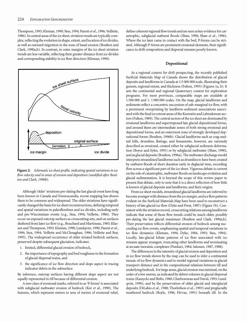
It is important to distinguish between the erosional and depositionalrecords because they are spatially and temporally distinct, formedbeneath the ice sheet at different times, in different locations, and by dif-ferent processes (e.g., Boulton, 1984; 1996a,b) (Figure 2). Whereas ero-sion occurs at the outer margins of an ice sheet during expansion,deposition occurs later, either at the glacial maximum or during degla-ciation. In central regions, near ice divides, ice tends to be protective ofits bed, and there the geological record can represent multiple glacialevents. Thus, the type, provenance, and relative age of the geologicalrecord, including striations, streamlined landforms, reflects geographicand glaciological context in the ice sheet, and can be expressed in termsof ice divides and ice flow dynamics, and spatial and temporal variationsin them (e.g., Aylsworth and Shilts, 1989; Boulton, 1984, 1996a,b; Boul-ton and Clark, 1990a,b; Bouchard and Salonen, 1989, 1990; Kleman,1990). The message for exploration is that relations among bedrock,drift composition, and ice flow history must be inferred in the widercontext of the ice sheet and glacial history and in terms of both erosionaland depositional records.
Erosional
Erosional features include striations and grooves on bedrock (milli-metres to tens of metres long), as well as streamlined forms developed inbedrock and in sediments overridden by the ice (tens of metres to kilo-metres). Striations are created by debris dragged by ice across its bed-rock surface and can define the trend and relative age of ice flow,although not the duration and distance of glacial transport associatedwith ice flow events (e.g., Prest, 1983; Kleman, 1990). They provide amore detailed and comprehensive record than glacial landforms alone,and are commonly used to reconstruct ice flow events and to unravelglacial transport paths for mineral exploration (e.g., Klassen and
224 Exploration Geochemistry
Thompson, 1993; Kleman, 1990; Stea, 1994; Parent et al., 1996; Veillette,1986). In central areas of the ice sheet, striation trends are typically com-plex, reflecting the evolution in shape, extent, and location of ice divides,as well as outward migration in the zone of basal erosion (Boulton andClark, 1990a,b). In contrast, in outer margins of the ice sheet striationtrends are less variable, reflecting their greater distance from ice dividesand corresponding stability in ice flow direction (Kleman, 1990).
Although ‘older’ striations pre-dating the last glacial event have longbeen known in Canada and Fennoscandia, recent mapping has shownthem to be common and widespread. The older striations have signifi-cantly changed the basis for ice sheet reconstructions, defining temporaland spatial variations in paleoflowlines and ice divides, including earlyand pre-Wisconsinan events (e.g., Stea, 1994; Veillette, 1986). Theyoccur on exposed outcrop surfaces as crosscutting sets, and on surfacessheltered from later ice flow (e.g., Bouchard and Martineau, 1985; Klas-sen and Thompson, 1993; Kleman, 1990; Lundqvist, 1990; Parent et al.,1996; Stea, 1994; Veillette and McClenaghan, 1996; Veillette and Roy,1995). The widespread occurrence of older striated bedrock surfaces,preserved despite subsequent glaciation, indicates:
1. limited, differential glacial erosion of bedrock,
2. the importance of topography and bed roughness to the formationof glacial dispersal trains, and
3. the significance of ice flow direction and slope aspect in tracingindicator debris in the subsurface.
By inference, outcrop surfaces having different slope aspect are notequally represented in till because of differential erosion.
A new class of erosional marks, referred to as ‘P-forms’ is associatedwith subglacial meltwater erosion of bedrock (Kor et al., 1990). Thefeatures, which represent metres to tens of metres of erosional relief,
define coherent regional flow trends and are seen as key evidence for cat-astrophic, subglacial outburst floods (Shaw, 1990; Shaw et al., 1996).Where the ice later came in contact with the bed, P-forms can be stri-ated. Although P-forms are prominent erosional elements, their signifi-cance to drift composition and dispersal remains poorly known.
Depositional
As a regional context for drift prospecting, the recently publishedSurficial Materials Map of Canada shows the distribution of glacialdeposits and landforms in Canada at 1:5 000 000 scale, illustrating theirgenesis, regional extent, and thickness (Fulton, 1995) (Figures 1a, b). Itsets the continental and regional Quaternary context for explorationprograms. For most provinces, comparable maps are available at1:500 000 and 1: 1 000 000 scales. On the map, glacial landforms andsediments reflect a concentric succession of sub-marginal ice flow, witha prominent overprinting by landform-sediment associations associ-ated with the final ice retreat areas of the Keewatin and Labradorean sec-tors (Fulton, 1989). The central sectors of the ice sheet are dominated byerosional landforms and superimposed late glacial depositional forms,and around them are intermediate zones of both strong erosional anddepositional forms, and an outermost zone of strongly developed dep-ositional forms (Boulton, 1996b). Glacial landforms such as crag-and-tail hills, drumlins, flutings, and lineaments, however, are variouslydescribed as erosional, created either by subglacial sediment deforma-tion (Boyce and Eyles, 1991) or by subglacial meltwater (Shaw, 1990),and as glacial deposits (Boulton, 1996a). The meltwater discharge modelinterprets streamlined landforms such as drumlins to have been createdby outburst floods of short duration early in deglacial time, recordingflow across a significant part of the ice sheet. Vigorous debate is currenton the role of catastrophic, meltwater floods on landscape evolution andglacial sedimentation. It is beyond the scope of this review paper topresent that debate, only to note that it is a direct reflection of how littleis known of glacial deposits and landforms, and their origins.
From ice sheet models, streamlined glacial landforms are inferred tobecome younger with distance from the ice margin, and ice flow patternsevident on the Surficial Materials Map have been used to reconstruct ahistory of late glacial ice flow (Dyke and Prest, 1987) (Figure 1b). Con-sistent with the striation record, crosscutting relations among landformsindicate that some of those flow trends could be much older, possiblypre-dating the last glacial maximum (Boulton and Clark, 1990a,b).Their preservation reflects differential erosion of bedrock among suc-ceeding ice flow events, emphasizing spatial and temporal variations inice flow dynamics (Kleman, 1994; Dyke, 1984, 1993; Stea, 1994).Locally, late-glacial lobate patterns of ice flow associated with icestreams appear youngest, truncating other landforms and terminatingat arcuate morainic complexes (Punkari, 1984; Salonen, 1987, 1988).
The differences in the intensity of glacial erosion and deposition andin ice flow trends shown by the map can be used to infer a continentalmosaic of ice flow dynamics and to model regional variations in glacialtransport distance and in the compositional relations between till andunderlying bedrock. For large areas, glacial erosion was minimal, on theorder of a few metres, as indicated by debris volumes in glacial dispersaltrains (Kaszycki and Shilts, 1980; Charbonneau and David, 1993; Lund-qvist, 1990), and by the preservation of older glacial and interglacialdeposits (DiLabio et al., 1988; Thorleifson et al., 1993) and preglaciallyweathered bedrock (Boyle, 1996; Hirvas, 1991) beneath till. In the
Figure 2: Schematic ice sheet profile, indicating spatial variations in iceflow velocity and in areas of erosion and deposition (modified after Boul-ton and Clark, 1990b).

Klassen, R.A. GLACIAL HISTORY AND ICE FLOW DYNAMICS 225
Arctic and along the eastern and northern continental margins, the icesheet was cold-based, and protective of its bed (Dredge, 1995; Dyke,1993; Dyke and Morris, 1988; Dyke et al., 1992). There, glacial transportdistances are minimal, and glacial deposits are difficult to distinguishfrom bedrock rubble; major landscape elements could be Tertiary age.Where flow was more rapid, either along major valleys and fiords, or inice streams, the effects of glacial erosion and transport are much greater,and the linkages between bedrock and drift composition more complex(Charbonneau and David, 1993; Dyke et al., 1992; Dredge, 1995).
The occurrence of older glacial and nonglacial sediments beneathsurface till further demonstrates incomplete glacial erosion during suc-ceeding glacial events, as well as compositional masking of underlyingbedrock. Buried deposits are widespread across the Prairies (Fenton,1984), Hudson Bay Lowlands (Thorleifson et al., 1993), and the south-ern margins of the ice sheet (Hansel et al., 1987), and recent work indi-cates they are likely more extensive. In northern Ontario and Québec,for example, overburden drilling has revealed numerous older depositspreserved as erosional remnants in topographic depressions, reflectingthe relief and topographic orientation of bedrock relative to ice flowdirection (DiLabio et al., 1988; McClenaghan et al., 1992; Smith, 1992).In Fennoscandia, multiple buried tills and interglacial organic depositsare characteristic of ice divide regions (Hirvas, 1991). Although little isknown of the subsurface near the Keewatin and Labradorean ice divides,the Fennoscandian work indicates that a comparable record could existthere. Conversely, thick (>10 m) deposits of waterlain sediment depos-ited in glaciolacustrine and glaciomarine environments occupy hugeareas, masking bedrock and till with sediment younger than the last gla-ciation (Figure 1a). In those areas, drift prospecting commonly requireseither excavation or overburden drilling to sample till (e.g., Brummer etal., 1992; Nichol et al., 1992; Schreiner, 1984; Smith, 1992).
Till classifications have increasingly reflected glacial process(Dreimanis, 1989, 1990). Although the field evidence required to makethose distinctions is commonly not available, especially in explorationpractice, they reflect the growth and sophistication of glacial sedimen-tology that has occurred over the past decade. In addition to composi-tional analysis, the determination of depositional process willundoubtedly lead to a more effective use of glacial deposits in indicatortracing at detailed scales of investigation, resolving evidence for variedlate glacial events affecting the compositional relation between surfacetill and underlying bedrock, including topographically directed ice,surging into glacial lakes, debris flow, and iceberg rafting.
To illustrate the potential utility of till classification to mineral explo-ration, and the linkages among regional ice flow dynamics, glacial pro-cess, and sediment composition, a recently identified till type,deformation till, is described here. Deformation of the ice bed mostlikely occurs in fine-grained sediment having low porosity and highporewater pressure, such as glacial lake and glaciomarine sedimentsoverridden by ice, and in fine-textured till derived from them (Boultonand Hindmarsh, 1987; Hicock et al., 1989). The resulting deformationtill is characterized by:
1. an abundance of fine-grained till matrix and faceted clasts reflect-ing intense abrasion and the incorporation of fine-grained oldersediment overridden by the ice,
2. either lack of structure through shear attenuation and homogeni-zation of sediments overridden by the ice, or complex folding(Hicock and Dreimanis, 1992),
3. sharp lower erosional contacts reflecting the limit of shear deforma-tion and the lower contact with undeformed glacial sediment, and
4. overconsolidation (Alley, 1991).
Because subglacial deformation may be characteristic of ice streams, thedistribution of deformation till can in part be determined from land-form-sediment associations, including:
1. lobate, radial patterns of ice flow defined by drumlins,
2. marked discontinuities in regional ice flow trends;
3. far-traveled (>50 km) debris extending down-ice from sourcesmuch wider than the train itself as well-defined plumes (Dyke,1984; Dyke and Morris, 1988; Dyke et al., 1992; Hicock et al., 1989;Thorleifson and Kristjansson, 1993), and
4. areas where ice has overridden fine-grained sediment (Boulton,1996a,b).
Thus, the occurrence of deformation till could indicate the wider distri-bution of a relatively thick, compositionally homogenous deposit char-acterized by significant glacial transport distance and bearing little or nocompositional relation to underlying bedrock. Further, there could wellbe an abrupt lateral transition to adjacent areas where till is closelylinked to underlying bedrock.
For indicator tracing, the origins and internal architecture of glaciallandforms, including drumlins (Graves and Finck, 1988) and morainiccomplexes (Stewart and Broster, 1990) are important. Not only are thelandforms widespread and areally extensive, but they are complex infacies, structure, and provenance, including glaciofluvial and otherwaterlain sediments as major components, as well as preglacial sedimentoverridden by the ice and organic deposits (Lundqvist, 1990). Thus,indicators of economic mineralization are difficult to trace if the variedsediment types comprising the landforms are sampled indiscriminantly(Aario and Peuraniemi, 1992). End and interlobate moraines, for exam-ple, mark either an ice flow terminus or suture zones between distinct icelobes or Sectors of the Laurentide Ice Sheet. In northern Manitoba, forexample, the Leaf Rapids Interlobate moraine marks the boundarybetween Keewatin and Labradorean ice (Figure 1b). To the east, Labra-dorean till is carbonate-rich through the incorporation of sedimentarybedrock from Hudson Bay, whereas to the west Keewatin till is ‘crystal-line’, derived from Shield terrane (e.g., Dredge, 1988). Through draw-down, ice flow can laterally shift toward ice margins, locallyredistributing glacial debris (Veillette, 1986).
GLACIAL DISPERSAL MODELS
In the past decade, both theoretical constructs of the Canadian andFennoscandian ice sheets (e.g., Boulton, 1984; 1996b) and empiricalmodels of glacial dispersal (e.g., Stea et al., 1989; Puranen, 1988, 1990),have clearly linked glacial history and spatial and temporal variations inice flow dynamics to drift composition. Theoretical models show that:
1. near ice divides there is minimal to no erosion of underlying bed-rock, and a complex history of glacial transport resulting in theirmovement over hundreds of kilometres,
2. erosion is most effective in the earliest phase of glaciation, in theouter margin of an expanding ice sheet,
3. deposition occurs in the outer margin of the ice sheet at its maxi-mum and during deglaciation, and

226 Exploration Geochemistry
4. the proportions of far-traveled to local debris in till increaseupward in glacial deposits, and with distance outward from the icedivide; far-traveled debris is more characteristic of glacial depositsin marginal areas than near ice divides (e.g., Boulton, 1984,1996a,b; Clark, 1987).
Glacial dispersal trains of varied indicator erratics that extend hundredsto thousands of kilometres from their source (e.g., Clark, 1987; Prest,1990) have been used to constrain paleoflowlines in ice sheet recon-structions (e.g., Boulton et al., 1985; Fisher et al., 1985). Because thetransport of erratics over thousands of kilometres is not readily accom-modated by a single ice flow event, the erratics indicate multi-cycle gla-cial erosion and transport.
In the past decade, empirical data have been used to further developmathematical models of glacial dispersal and to identify regional differ-ences among factors affecting dispersal. Numerous workers have shownthat indicator concentrations in till decrease exponentially with distancedown-ice from a source (e.g., Clark, 1987; Finck and Stea, 1995; Gill-berg, 1965; Salonen, 1987, 1992; Shilts, 1976; Parent et al., 1996). Therelation is expressed in the form:
[1]
where: y is the debris concentration at a point along the path of ice flow,y
0 is the maximum concentration achieved either at or down-ice of the
source (100%), x is the distance of transport down-ice of the maximum,e represents the base of the natural logarithm, and a is a constant reflect-ing the rate of decay (Gillberg, 1965). With distance of ice flow across asource, it follows that indicator concentrations also increase exponen-tially as the result of uptake by the ice (Finck and Stea, 1995; Peltoniemi,1985) (Figure 3). Together, the curves for uptake and deposition give thecharacteristic dispersal profile which rises rapidly to a ‘head’ either overor directly down-ice of the source, and decreases in a ‘tail’, defined byindicator concentrations slightly elevated above background concentra-tions, stretching down-ice (e.g., Shilts, 1976). Till in the tail is most likelyto be sampled because it comprises the most extensive part of the dis-persal train. Thus, in mineral exploration there is a need to discriminatethe faint signal of mineralization in the tail from ‘noise’ related to glacialprocess and to geological variability, and it is in that context that glacialdispersal models contribute to exploration.
The shape of the exponential curve is reflected by ‘a’, which relates to:
1. the velocity and duration of ice flow (Aario and Peuraniemi, 1992;Bouchard and Salonen, 1990; Clark, 1987; Dyke, 1984),
2. the physical properties of the source, including its areal extent,topographic exposure (Clark, 1987; Salonen, 1992), and its suscep-tibility to glacial erosion and comminution (Gillberg, 1965), and
3. the balance between re-entrainment of older glacial debris andaddition of new detritus from bedrock (Parent et al., 1996).
From empirical studies, ‘a’ can be viewed as a sum of constants for eachof the controls listed above (e.g., Gillberg, 1965; Clark, 1987).
Glacial transport distance is characterized as a ‘geometric mean’ or a‘half-distance’ (Pertunnen, 1977), which is the distance for peak concen-trations to decrease to half their maximum value (Gillberg, 1965) (Fig-ure 3); the two terms are equivalent (Bouchard and Salonen, 1990). Halfdistance can vary widely, although numerous reports indicate that thebulk of glacial deposits have undergone limited transport, on the orderof hundreds of metres to several kilometres (<10 km) (Clark, 1987;
y yo e ax–⋅=
Figure 3: Schematic profiles illustrating compositional variations ofindicator erratics with distance of glacial transport, and their expected dis-tribution in till. (a) Exponential ‘uptake’ and ‘decay’ curves reflect erosion,modification, and deposition of debris transported at the base of the ice.(b) Linear decay reflects englacial transport with little or no modificationof debris, and may be characteristic of dispersal by ice streams where flowoccurs by deformation in the ice bed.
Klassen, R.A. GLACIAL HISTORY AND ICE FLOW DYNAMICS 227
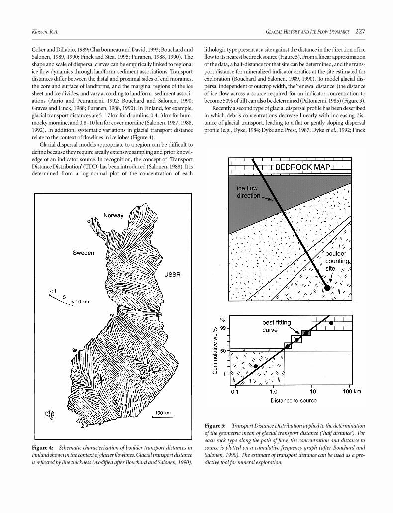
Coker and DiLabio, 1989; Charbonneau and David, 1993; Bouchard andSalonen, 1989, 1990; Finck and Stea, 1995; Puranen, 1988, 1990). Theshape and scale of dispersal curves can be empirically linked to regionalice flow dynamics through landform-sediment associations. Transportdistances differ between the distal and proximal sides of end moraines,the core and surface of landforms, and the marginal regions of the icesheet and ice divides, and vary according to landform–sediment associ-ations (Aario and Peuraniemi, 1992; Bouchard and Salonen, 1990;Graves and Finck, 1988; Puranen, 1988, 1990). In Finland, for example,glacial transport distances are 5–17 km for drumlins, 0.4–3 km for hum-mocky moraine, and 0.8–10 km for cover moraine (Salonen, 1987, 1988,1992). In addition, systematic variations in glacial transport distancerelate to the context of flowlines in ice lobes (Figure 4).
Glacial dispersal models appropriate to a region can be difficult todefine because they require areally extensive sampling and prior knowl-edge of an indicator source. In recognition, the concept of ‘TransportDistance Distribution’ (TDD) has been introduced (Salonen, 1988). It isdetermined from a log-normal plot of the concentration of each
lithologic type present at a site against the distance in the direction of iceflow to its nearest bedrock source (Figure 5). From a linear approximationof the data, a half-distance for that site can be determined, and the trans-port distance for mineralized indicator erratics at the site estimated forexploration (Bouchard and Salonen, 1989, 1990). To model glacial dis-persal independent of outcrop width, the ‘renewal distance’ (the distanceof ice flow across a source required for an indicator concentration tobecome 50% of till) can also be determined (Peltoniemi, 1985) (Figure 3).
Recently a second type of glacial dispersal profile has been describedin which debris concentrations decrease linearly with increasing dis-tance of glacial transport, leading to a flat or gently sloping dispersalprofile (e.g., Dyke, 1984; Dyke and Prest, 1987; Dyke et al., 1992; Finck
Figure 4: Schematic characterization of boulder transport distances inFinland shown in the context of glacier flowlines. Glacial transport distanceis reflected by line thickness (modified after Bouchard and Salonen, 1990).
Figure 5: Transport Distance Distribution applied to the determinationof the geometric mean of glacial transport distance (‘half distance’). Foreach rock type along the path of flow, the concentration and distance tosource is plotted on a cumulative frequency graph (after Bouchard andSalonen, 1990). The estimate of transport distance can be used as a pre-dictive tool for mineral exploration.

228 Exploration Geochemistry
and Stea, 1995; Kaszycki, 1989; Dredge, 1995; Thorleifson and Kristjan-sson, 1993) (Figure 3). In contrast to exponential profiles which relate tobasal transport, the flat profile is more likely associated with englacialtransport, indicating little or no modification of englacial debris bycrushing and abrasion, and no ongoing addition of bedrock detritusduring glacial transport. Such dispersal can be modelled as a conveyorbelt, with no mixing between the ice bed and englacial debris, and maybe characteristic of ice stream flow.
Shape of glacial dispersal trains
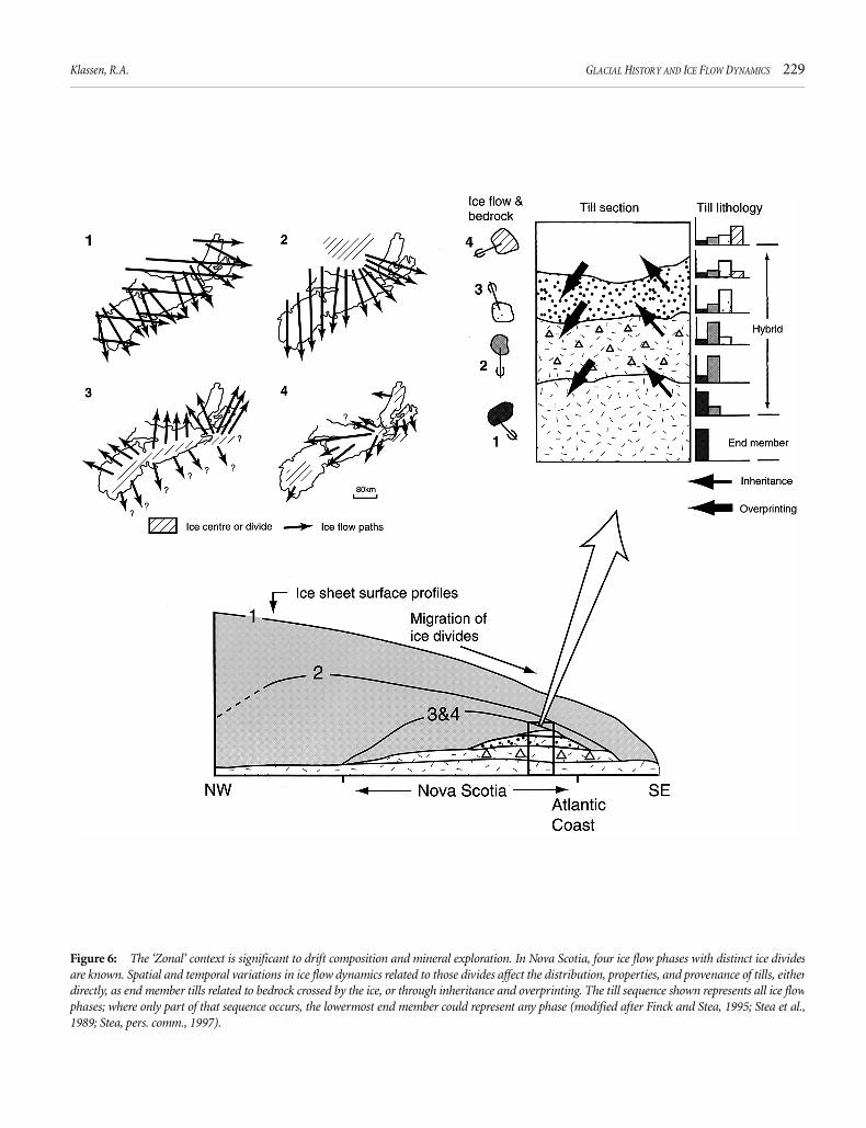
Recent mapping of glacial dispersal trains has emphasized the link-ages between their size, shape, and orientation of glacial dispersal trains,geographic and glaciological context in the ice sheet, and ice flowdynamics. Where the Laurentide Ice Sheet merged with adjacent glaciercomplexes, as it did with the Appalachian glacier complex along itssoutheastern margin, drift composition can reflect both long-continuedregional flow in the outer margins of a continental ice sheet and flownear ice divides comprising part of the smaller maritime ice sheet (Char-bonneau and David, 1993; Stea et al., 1989; Pronk et al., 1989; Rappol,1989; Shilts and Smith, 1989). Maritime ice caps are characterized bycomplex flow patterns that reflect topographic effects as well as interac-tion with the Laurentide Ice Sheet. To recognize the effects of competingice sheets and changing ice divides, in Nova Scotia drift composition isdescribed in a ‘Zonal’ context (Stea et al., 1989) (Figure 6). Dispersalassociated with the Laurentide Ice Sheet and Appalachian ice centresoutside the province (Phase 1a, b) is along regionally prominent flowpaths, and debris includes a significant component of far-traveled detri-tus. From local dispersal centres (Phases 2, 3, 4), there is greater arealvariation in ice flow direction and glacial transport distance, and in theintensity of glacial process and comminution of glacial debris, reflectedby the textural maturity of till. In till, differences in texture and driftprovenance thus reflect the physical properties of bedrock as well asZonation in the ice sheet.
The dispersal trains can be classified as ‘ribbon’, ‘fan’ or ‘amoeboid’,according to their outline shape. Ribbons are streamed along a single iceflow direction, with a width comparable to the outcrop source, measuredperpendicular to ice flow. The more classical fan broadens down-ice,with its outer margins aligned in the two most divergent directions of iceflow. Striations have been used to estimate maximum fan divergence andto define a probability sector for tracing indicators in an up-ice direction(Hirvas, 1989). Near ice divides, where flow variation is marked, includ-ing reversal of flow, ‘amoeboid’ dispersal trains of indefinite shape extendin all directions about their source (e.g., Parent et al., 1996). Composi-tional variations in drift result from continued erosion of bedrock, aswell as recycling of debris during succeeding glacial events, and they canreflect differences in glacial process among events. ‘End-member’ tillresults from subglacial processes associated with a single ice event,whereas ‘hybrid’ till is the product of multiple glacial events (Finck andStea, 1995) (Figure 6). Hybrid till results from either ‘inheritance’, whereolder glacial deposits are incorporated in younger till, or ‘overprinting’,where later glacial events impress a compositional record on underlying,older glacial deposits. Where older trains served as sources of indicatordebris to later glacial events (e.g., Charbonneau and David, 1993;Klassen and Thompson, 1993; Parent et al., 1996), ‘palimpsest’ glacialdispersal trains (Parent et al., 1996) occur, comprising hybrid till with acomponent inherited from earlier advance and modified by later flow.
In some cases, the head of a glacial dispersal train terminates with noapparent surface connection to its bedrock source. Lithologic variationin vertical till profiles can indicate change in:
1. ice flow direction and provenance, and
2. distance of glacial transport associated with either change in iceflow velocity or in the position of debris in the ice (i.e., englacial vs.basal) (e.g., Boulton, 1984, 1996a,b; Hansel et al., 1987).
In simple situations where only one till occurs, indicator concentrationsare typically greatest at the base of the depoist, directly over the source,and it has commonly been observed that the dispersal train rises in adown-ice direction within the till sheet at a low angle of inclination. Thedistance between the bedrock source and the first appearance of the dis-persal train at the surface tends to increase with till thickness. The ver-tical rise has been attributed to continued erosion of the source andaddition of debris to the base of the ice sheet along the path of flow(Puranen, 1988, 1990), and more recently to upward ‘shear diffusion’ ina deforming bed (Charbonneau and David, 1995). In exploration, theup-ice gap between the head of the dispersal train and its bedrock occur-rence must be prospected in the subsurface by trenching or drilling.
Where debris is introduced high into the ice from a topographicprominence it can be transported englacially with little or no modifica-tion by intra-clast contact. Deposition occurs where the debris isbrought into contact with the bed farther down ice, for example at atopographic obstruction (Batterson, 1989; Puranen, 1990). Zones ofnon-deposition along the path of ice flow have been termed ‘skip zones’(Finck and Stea, 1995). Separation between the head of a train and itssource can also occur through glacial erosion and removal of debris dur-ing later events (Stea et al., 1989), or where the train is partially coveredby other glacial sediment. Topographic obstructions can also lead tonon-deposition in lee sides of hills, and interruption in glacial dispersalpatterns (Gillberg, 1965; Shilts, 1976).
SUMMARY
The incorporation of physical and geological factors in ice sheet modelshas lead to major revisions in our view of the Laurentide Ice Sheet andits landform-sediment record. The work clearly indicates how regionalice flow dynamics, and spatial and temporal variations in them, can beinferred from regional Quaternary mapping and used to determineeffective strategies and practices for mineral exploration at local anddetailed scales. The complex record of Quaternary geology that is char-acteristic of glaciated terrain, can be unraveled in the context of geo-graphic and glaciological context in the ice sheet, and should not besimply viewed as an unexpected impediment to exploration. Over thenext decade ice sheet models will undoubtedly be further revised withthe inclusion of additional physical factors and glaciological principles.For mineral exploration, however, the value of these models is deter-mined almost exclusively by their accuracy in describing particle trans-port paths and distances. For that reason, there is a continuing need todefine glacial dispersal models through empirical evidence and to mod-ify theoretical models according to it. Although the area of glaciated ter-rain is vast, the geochemical, mineralogical and lithological databasesdefined by regional surveys will continue to serve as importantresources, providing a context for tracing indicator debris and interpret-ing till geochemistry.
Klassen, R.A. GLACIAL HISTORY AND ICE FLOW DYNAMICS 229
Figure 6: The ‘Zonal’ context is significant to drift composition and mineral exploration. In Nova Scotia, four ice flow phases with distinct ice dividesare known. Spatial and temporal variations in ice flow dynamics related to those divides affect the distribution, properties, and provenance of tills, eitherdirectly, as end member tills related to bedrock crossed by the ice, or through inheritance and overprinting. The till sequence shown represents all ice flowphases; where only part of that sequence occurs, the lowermost end member could represent any phase (modified after Finck and Stea, 1995; Stea et al.,1989; Stea, pers. comm., 1997).
230 Exploration Geochemistry
ACKNOWLEDGEMENTS
Ms. B. McClenaghan is thanked for her careful review, and Drs. R. N. W.DiLabio, P. J. Henderson, and R. R. Stea for their encouragement andsuggestions, all of which have helped to improve the manuscript.
REFERENCES
Aario, R., and Peuraniemi, V., 1992, Glacial dispersal of till constituents inmorainic landforms of different types, in Aario, R., and Heikkinen, H., eds.,Proceedings of the Third International Drumlin Symposium: Geomorphol-ogy, 6, 9-25.
Alley, R.B., 1991, Deforming-bed origin for the southern Laurentide till sheets?:Journal of Glaciology, 37, 67-76.
Aylsworth, J.A., and Shilts, W.W., 1989, Glacial features around the Keewatin IceDivide: Districts of Mackenzie and Keewatin: Paper 88-24: Geological Surveyof Canada.
Batterson, M.J., 1989, Glacial dispersal from the Strange Lake alkalic complex,northern Labrador, in DiLabio, R.N.W., and Coker, W.B., eds., Drift Pros-pecting: Paper 89-20: Geological Survey of Canada, 31-39.
Bentley, C.R., 1987, Antarctic ice streams: a review: Journal of GeophysicalResearch, 92, 8843-8858.
Boyle, D.R., 1996, 4.2 Supergene base metals and precious metals, in Eckstrand,O.R., Sinclair, W.D., and Thorpe, R.I., eds., Geology of Canadian MineralDeposit Types: Geology of Canada, no.8: Geological Survey of Canada, 92-108.
Bouchard, M.A., and Martineau, G., 1985, Southeastward ice flow in centralQuébec and its paleogeographic significance: Canadian Journal of EarthSciences, 22, 1536-1541.
Bouchard, M.A., and Salonen, V.-P., 1989, Glacial dispersal of boulders in theJames Bay lowlands of Québec, Canada: Boreas, 18, 189-199.
Bouchard, M.A., and Salonen, V.-P., 1990, Boulder transport in shield areas, inKujansuu, R., and Saarnisto, M., eds., Glacial Indicator Tracing: A.A.Balkema, 87-107.
Boulton, G.S., 1984, Development of a theoretical model of sediment dispersal byice sheets, in Prospecting in Areas of Glaciated Terrain 1984: Institute of Min-ing and Metallurgy, 213-223.
Boulton, G.S., 1996a, The origin of till sequences by subglacial sediment defor-mation beneath mid-latitude ice sheets: Annals of Glaciology, 22, 75-84.
Boulton, G.S., 1996b, Theory of glacial erosion, transport and deposition as aconsequence of subglacial sediment deformation: Journal of Glaciology, 42.
Boulton, G.S., and Clark, C.D., 1990a, A highly mobile Laurentide Ice Sheetrevealed by satellite images of glacial lineations: Nature, 346, 813-817.
Boulton, G.S., and Clark, C.D., 1990b, The Laurentide ice sheet through the lastglacial cycle: the topology of drift lineations as a key to the dynamic behav-iour of former ice sheets: Transactions of the Royal Society of Edinburgh:Earth Sciences, 81, 327-347.
Boulton, G.S., and Hindmarsh, R.C.A., 1987, Sediment deformation beneath gla-ciers: rheology and geological consequences: Journal of GeophysicalResearch, 92, 9059-9082.
Boulton, G.S., Smith, G.D., John, A.S., and Newsome, J., 1985, Glacial geologyand glaciology of the last mid-latitude ice sheets: Journal of the GeologicalSociety, London, 142, 447-474.
Boyce, J.I., and Eyles, N., 1991, Drumlins carved by deforming ice streams belowthe Laurentide ice sheet: Geology, 19, 787-790.
Boyle, D.R., 1996, 4.2 Supergene base metals and precious metals, in Eckstrand,O.R., Sinclair, W.D., and Thorpe, R.I., eds., Geology of Canadian MineralDeposit Types: Geology of Canada, no. 8, Geol. Survey of Canada, 92-108.
Brummer, J.J., MacFadyen, D.A., and Pegg, C.C., 1992, Discovery of Kimberlitesin the Kirkland Lake Area Northern Ontario, Canada. Part I: Early Surveysand the Surficial Geology: Exploration Mining Geology, 1, 339-350.
Budd, W., F., and Smith, I.N., 1987, Conditions for growth and retreat of the Lau-rentide Ice Sheet: Géographie physique et quaternaire, XLI, 279-290.
Charbonneau, R., and David, P.P., 1993, Glacial dispersal of rock debris in centralGaspésie, Québec, Canada: Canadian Journal of Earth Sciences, 30, 1697-1707.
Charbonneau, R., and David, P.P., 1995, A shear-diffusion model of till genesisbased on the dispersal pattern of indicator rocks in the Grand-Volume Till ofcentral Gaspésie, Québec, Canada: Boreas, 24, 281-292.
Clark, C.D., 1993, Mega-scale glacial lineations and cross-cutting ice-flow land-forms.: Earth Surface Processes and Landforms, 18, 1-29.
Clark, P.U., 1987, Subglacial sediment dispersal and till composition: Journal ofGeology, 95, 527-541.
Coker, W.B., and DiLabio, R.N.W., 1989, Geochemical exploration in glaciatedterrain: geochemical responses, in Proceedings of Exploration ’87: ThirdDecennial International Conference on Geophysical and Geochemical Explo-ration for Minerals and Groundwater, Ontario Geological Survey, 336-383.
DiLabio, R.N.W., Miller, R.F., Mott, R.J., and B., C.W., 1988, The Quaternarystratigraphy of the Timmins area, Ontario, as an aid to mineral explorationby drift prospecting, Current Research, Part C: Paper 88-1C: Geological Sur-vey of Canada, 61-65.
Dredge, L.A., 1988, Drift carbonate on the Canadian Shield. II: Carbonate dis-persal and ice-flow patterns in northern Manitoba (Note): Canadian Journalof Earth Sciences, 25, 783-787.
Dredge, L.A., 1995, Quaternary geology, of northern Melville Peninsula, Districtof Franklin; Northwest Territories: surface deposits, glacial history, environ-mental geology, and till geochemistry: Bulletin 484: Geol. Survey of Canada.
Dreimanis, A., 1989, Tills: their genetic terminology and classification, in Gold-thwait, R.P., and Matsch, C.L., eds., Genetic Classification of GlaciogenicDeposits: Final Report of the Commission on Genesis and Lithology of Gla-cial Quaternary Deposits of the International Union for Quaternary Research(INQUA): A.A. Balkema, 17-83.
Dreimanis, A., 1990, Chapter 3. Formation, deposition, and identification of sub-glacial and supraglacial tills, in Kujansuu, R., and Saarnisto, M., eds., GlacialIndicator Tracing: A.A. Balkema, 35-59.
Dyke, A.S., 1984, Quaternary geology of Boothia Peninsula and northern Dis-trict of Mackenzie, central Canadian Arctic: Bulletin 407: Geological Surveyof Canada.
Dyke, A.S., 1993, Landscapes of cold-centred Late Wisconsinan ice caps, ArcticCanada: Progress in Physical Geography, 17, 223-247.
Dyke, A.S., and Morris, T.F., 1988, Drumlin fields, dispersal trains, and icestreams in Arctic Canada: The Canadian Geographer, 32, 86-90.
Dyke, A.S., Morris, T.F., Green, D.E.C., and England, J., 1992, Quaternary Geol-ogy of Prince of Wales Island, Arctic Canada: Memoir 433: Geological Surveyof Canada.
Dyke, A.S., and Prest, V.K., 1987, Late Wisconsinan and Holocene history of theLaurentide Ice Sheet: Géographie physique et quaternaire, XLI, 237-263.
Fenton, M.M., 1984, Quaternary stratigraphy of the Canadian Prairies, in Fulton,R.J., ed., Quaternary Stratigraphy of Canada: Paper 84-10: Geological Surveyof Canada, 57-68.
Finck, P.W., and Stea, R.R., 1995, The compositional development of tills over-lying the South Mountain Batholith, Nova Scotia: Paper 95-1: Department ofNatural Resources, Mines and Energy Branches.
Fisher, D.A., Reeh, N., and Langley, K., 1985, Objective reconstructions of theLate Wisconsinan Laurentide Ice Sheet and the significance of deformablebeds: Géographie physique et Quaternaire, 39, 229-238.
Fulton, R.J., 1989, Chapter 3. Quaternary geology of the Canadian Shield, in Ful-ton, R.J., ed., Quaternary Geology of Canada and Greenland: Geology ofCanada No. 1: Geological Survey of Canada, 177-317.
Fulton, R.J. (complier), 1995, Surficial Materials of Canada, Map 1880A, scale1:5 000 000.
Gillberg, G., 1965, Till distribution and ice movements on the northern slopes ofthe south Swedish highlands: Geologiska Foreningens i Stockholm Förhan-dlingar, 86, 433-484.
Graves, R.M., and Finck, P.W., 1988, The provenance of tills overlying the easternpart of the South Mountain batholith, Nova Scotia: Maritime Sediments andAtlantic Geology, 24, 61-70.
Hansel, A.K., Johnson, W.H., and Socha, B.J., 1987, Sedimentological character-istics and genesis of basal tills at Wedron, Illinois, in Kujansuu, R., andSaarnisto, M., eds., INQUA Till Symposium, Finland, 1985: Special Paper 3:Geological Survey of Finland, 11-21.

Klassen, R.A. GLACIAL HISTORY AND ICE FLOW DYNAMICS 231
Hicock, S.R., and Dreimanis, A., 1992, Deformation till in the Great Lakes region:implications for rapid flow along the south-central margin of the LaurentideIce Sheet: Canadian Journal of Earth Sciences, 29, 1565-1579.
Hicock, S.R., Kristjansson, F.J., and Sharpe, D.R., 1989, Carbonate till as a softbed for Pleistocene ice streams on the Canadian Shield north of Lake Supe-rior: Canadian Journal of Earth Sciences, 26, 2249-2254.
Hirvas, H., 1989, Application of glacial geological studies in prospecting, Fin-land, in DiLabio, R.N.W., and Coker, W.B., eds., Drift Prospecting: Paper 89-20: Geological Survey of Canada, 1-6.
Hirvas, H., 1991, Pleistocene stratigraphy of Finnish Lapland: Bulletin 354: Geo-logical Survey of Finland.
Kaszycki, C.A., 1989, Surficial geology and till composition, northwestern Man-itoba: Open File 2118: Geological Survey of Canada.
Kaszycki, C.A., and Shilts, W.W., 1980, Glacial erosion of the Canadian Shield—calculation of average depths: Technical Record TR-106: Atomic Energy ofCanada Ltd.
Klassen, R.A., and Thompson, F.J., 1993, Glacial history, drift composition, andmineral exploration, central Labrador: Bulletin 435: Geol. Survey of Canada.
Kleman, J., 1990, On the use of glacial striae for reconstruction of paleo-ice sheetflow patterns—With application to the Scandinavian ice sheet: GeografiskaAnnaler, 72A, 217-236.
Kleman, J., 1994, Preservation of landforms under ice sheets and ice caps: Geo-morphology, 9, 19-32.
Kor, P.S.G., Shaw, J., and Sharpe, D.R., 1990, Erosion of bedrock by subglacialmeltwater, Georgian Bay, Ontario: a regional view: Canadian Journal of EarthSciences, 28, 623-642.
Lundqvist, J., 1990, Chapter 4: Glacial morphology as an indicator of the direc-tion of ice flow, in Kujansuu, R., and Saarnisto, M., eds., Glacial IndicatorTracing: A. A. Balkema, 61-70.
Marshall, S.J., Clarke, G.K., Dyke, A.S., and Fisher, D.A., 1996, Geologic andtopographic controls on fast flow in the Laurentide and Cordilleran IceSheets: Journal of Geophysical Research, 101, 17, 827-17,839.
McClenaghan, M.B., Lavin, O.P., Nichol, I., and Shaw, J., 1992, Geochemistry andclast lithology as an aid to till classification, Matheson, Ontario, Canada:Journal of Geochemical Exploration, 42, 237-260.
Nichol, I., Lavin, O.P., McClenaghan, M.B., and Stanley, C.R., 1992, The optimi-zation of geochemical exploration for gold using glacial till: Exploration Min-ing Geology, 1, 305-326.
Parent, M., Paradis, S.J., and Doiron, A., 1996, Palimpsest glacial dispersal trainsand their significance for drift prospecting: Journal of ExplorationGeochemistry, 56, 123-140.
Peltoniemi, H., 1985, Till lithology and glacial transport in Kuhmo, eastern Fin-land: Boreas, 14, 67-74.
Pertunnen, M., 1977, The lithologic relation between till and bedrock in theregion of Hameenlinna, southern Finland; Geological Survey of Finland,Bulletin 291, 68 p.
Prest, V.K., 1983, Canada’s Heritage of Glacial Features: Miscellaneous Report 28:Geological Survey of Canada.
Prest, V.K., 1984, The Late Wisconsinan Glacier Complex, in Fulton, R.J., ed.,Quaternary Stratigraphy of Canada—A Canadian contribution to IGCPProject 24: Paper 84-10: Geological Survey of Canada, 21-36.
Prest, V.K., 1990, Laurentide ice-flow patterns: a historical review, and implica-tions of the dispersal of Belcher Island erratics: Géographie physique et Qua-ternaire, 44, 113-136.
Pronk, A.G., Bobrowsky, P.T., and Parkhill, M.A., 1989, An interpretation of LateQuaternary glacial flow indicators in the Baie des Chaleurs region, northernNew Brunswick: Géographie physique et Quaternaire, 43, 179-190.
Punkari, M., 1984, The relations between glacial dynamics and tills in the easternpart of the Baltic Shield, in Königsson, L.-K., ed., Ten Years of NordicResearch: Striae, 20, 49-54.
Puranen, R., 1988, Modelling of glacial transport of basal tills in Finland: Reportof Investigation 81: Geological Survey of Finland.
Puranen, R., 1990, Chapter 2. Modelling of glacial transport of tills, in Kujansuu,R., and Saarnisto, M., eds., Glacial Indicator Tracing: A. A. Balkema, 15-34.
Rappol, M., 1989, Glacial history and stratigraphy of northwestern New Brun-swick: Géographie physique et quaternaire, 43, 191-206.
Salonen, V.-P., 1987, Observations on boulder transport in Finland, in Kujansuu,R., and Saarnisto, M., eds., INQUA Till Symposium: Special Paper 3: Geolog-ical Survey of Finland, 103-110.
Salonen, V.-P., 1988, Application of glacial dynamics, genetic differentiation ofglaciogenic deposits and their landforms to indicator tracing in the search forore deposits, in Goldthwait, R.P., and Matsch, C.L., eds., Genetic Classifica-tion of Glaciogenic Deposits: A. A. Balkema, 183-190.
Salonen, V.-P., 1992, Chapter 6. Glaciogenic dispersion of coarse till fragments, inKauranne, L.K., Salminen, R., and Eriksson, K., eds., Regolith ExplorationGeochemistry in Arctic and Temperate Terrains: Handbook of ExplorationGeochemistry: Elsevier, 5, 127-142.
Schreiner, B.T., 1984, Quaternary Geology of the Precambrian Shield,Saskatchewan: Report 221: Saskatchewan Energy and mines, SaskatchewanGeological Survey.
Shaw, J., 1990, A qualitative view of sub-ice-sheet landscape evolution: Progressin Physical Geography, 18, 159-184.
Shaw, J., Rains, B., Eyton, R., and Weissling, L., 1996, Laurentide subglacial out-burst floods: landform evidence from digital elevation models: CanadianJournal of Earth Sciences, 33, 1154-1168.
Shilts, W.W., 1976, Glacial till and mineral exploration, Glacial till: A Sympo-sium, 205-224.
Shilts, W.W., 1979, Flow patterns in the central North American ice sheet: Nature,286, 213-218.
Shilts, W.W., 1984, Till geochemistry in Finland and Canada: Journal ofGeochemical Exploration, 21, 95-117.
Shilts, W.W., 1993, Geological Survey of Canada’s contributions to understandingthe composition of glacial sediments, in Wheeler, J.O., ed., Canadian Journalof Earth Sciences: 150th anniversary of the Geological Survey of Canada;Contributions by the GSC to Canadian geoscience, 30, 333-353.
Shilts, W.W., and Smith, S.L., 1989, Drift prospecting in the Appalachians ofEstrie-Beauce, Québec, in DiLabio, R.N.W., and Coker, W.B., eds., DriftProspecting: Paper 89-20: Geological Survey of Canada, 41-59.
Smith, S.L., 1992, Quaternary stratigraphic drilling transect, Timmins to theMoose River Basin, Ontario: Bulletin 415: Geological Survey of Canada.
Stea, R.R., 1994, Relict and palimpsest glacial landforms in Nova Scotia, Canada,in Warren, W.P., and Croot, D.G., eds., Formation and Deformation of Gla-cial Deposits: A.A. Balkema, 141-158.
Stea, R.R., Turner, R.G., Finck, P.W., and Graves, R.M., 1989, Glacial dispersal inNova Scotia: a zonal concept, in DiLabio, R.N.W., and Coker, W.B., eds., DriftProspecting: Paper 89-20: Geological Survey of Canada, 155-169.
Stewart, R.A., and Broster, B.E., 1990, Chapter 8. Compositional variability of tillin marginal areas of continental glaciers, in Kujansuu, R., and Saarnisto, M.,eds., Glacial Indicator Tracing: A. A. Balkema, 123-149.
Thorleifson, L.H., and Kristjansson, F.J., 1993, Quaternary geology and driftprospecting, Beardmore-Geralton area, Ontario: Memoir 435: GeologicalSurvey of Canada.
Thorleifson, L.H., Wyatt, P.H., and Warman, T.A., 1993, Quaternary stratigraphyof the Severn and Winisk drainage basins, northern Ontario: Bulletin 442:Geological Survey of Canada.
Veillette, J.J., 1986, Former southwesterly ice flows in the Abitibi-Timiskamingregion: implications for the configuration of the late Wisconsinan ice sheet:Canadian Journal of Earth Sciences, 23, 1724-1741.
Veillette, J.J., 1989, Ice movements, till sheets and glacial transport in Abitibi-Timiskaming, Que. Prospecting: Paper 89-20: Geol. Survey of Canada, 139-154.
Veillette, J.J., and McClenaghan, M.B., 1996, Sequence of glacial ice flows inAbitibi-Timiskamming: implications for mineral exploration and dispersalof calcareous rocks from the Hudson bay Basin, Québec and Ontario: OpenFile 3033, map 1:500 000: Geological Survey of Canada.
Veillette, J.J., and Roy, M., 1995, The spectacular cross-striated outcrops of JamesBay, Québec, Current Research, 1995-C: Geol. Survey of Canada, 243-248.

232 Exploration Geochemistry