gis strategic plan - cgia.orgcgia.org/wp-content/uploads/2013/04/virginia-geographic... · 3 | page...
TRANSCRIPT
GIS Strategic Plan2015-2020
“Using geographic knowledge to create a better Virginia.”

2 | P a g e
Table of Contents Table of Contents .......................................................................................................................................... 2
Executive Summary ....................................................................................................................................... 3
Background ................................................................................................................................................... 4
VGIN History and Mission ................................................................................................................... 4
VGIN Business and Financial Model..................................................................................................... 4
VGIN Products and Services ................................................................................................................ 5
Purpose of the GIS Strategic Plan 5 Year Update ................................................................................ 5
GIS Strategic Plan 5 Year Update .................................................................................................................. 6
Planning Approach and Methodology ................................................................................................. 6
Acronyms and Key Terms ................................................................................................................... 7
VGIN 2015-2020 Goals and Strategic Initiatives ........................................................................................... 9
Vision .................................................................................................................................................. 9
Goal 1 - Coordination and Collaboration . ............................................................................................ 9
Goal 2 - Technical Services and Products . ......................................................................................... 15
Goal 3 - Education and Best Practices . .............................................................................................. 20
Appendix A: The Code of Virginia Establishing VGIN’s Existence and Mandate ......................................... 23
Appendix B: Planning Process and Stakeholder Outreach ......................................................................... 25
Appendix C: Stakeholder Input: Programs, Initiatives, and Challenges ..................................................... 31
Appendix D: Online Survey Summary ........................................................................................................ 39
Appendix E: Public Comments on Strategic Plan ....................................................................................... 58

3 | P a g e
Executive Summary In 2010, the Virginia Geographic Information Network (VGIN) published its first GIS Strategic Plan covering the period from January 2010 to January 2015. This plan established a Vision, Goals, and associated Initiatives that assisted VGIN in keeping focus on resources and priorities that are important to the Commonwealth of Virginia’s GIS stakeholder community. The process was successful and the plan has served as an important guiding document over the last five years.
This 2015-2020 GIS Strategic Plan is an update of this original effort and was developed using similar stakeholder outreach methodologies. The stakeholder outreach process began in October 2015 with five town hall meetings held successively in Hampton Roads, Richmond, Northern Virginia, Charlottesville, Roanoke, and Abingdon. A statewide webinar was also conducted in order to allow for participation by anyone unable to attend a local meeting. Supplementing the town hall meetings was a detailed on-line survey as well as individual stakeholder interviews.
The outreach process focused on getting feedback on existing VGIN programs and more importantly, seeking input on the challenges of the upcoming 2015-2020 time period. The input received through this process has been broad based, helpful and productive. The high level of participation and meaningful input is a credit to the work that VGIN, PSC (Public Safety Communications) and the Regional Coordinators have accomplished over the five years and will serve as a foundation for moving forward.
VGIN serves as a central and guiding role for GIS in the Commonwealth with its financial model predominately funded by the E-911 Services Board. This role is reflected through VGIN’s coordination and outreach that is performed at the state agency, local, regional, educational, and private levels across Virginia. The challenges facing the GIS community in the coming five years are broad and diverse. They include not only satisfying existing business requirements of analysis and data maintenance, but also emerging requirements such as Next Generation 9-1-1.
Meeting these challenges will require the combined effort of VGIN and all of the involved stakeholders. VGIN’s role is to provide effective and efficient technical services and products at a statewide level. The role of the stakeholders is to continue to provide a high level of involvement, feedback, and information related to new and innovative solutions being deployed.
Together, VGIN and the stakeholders will make significant progress towards the constant Vision:
Using geographic knowledge to create a better Virginia
4 | P a g e
Background
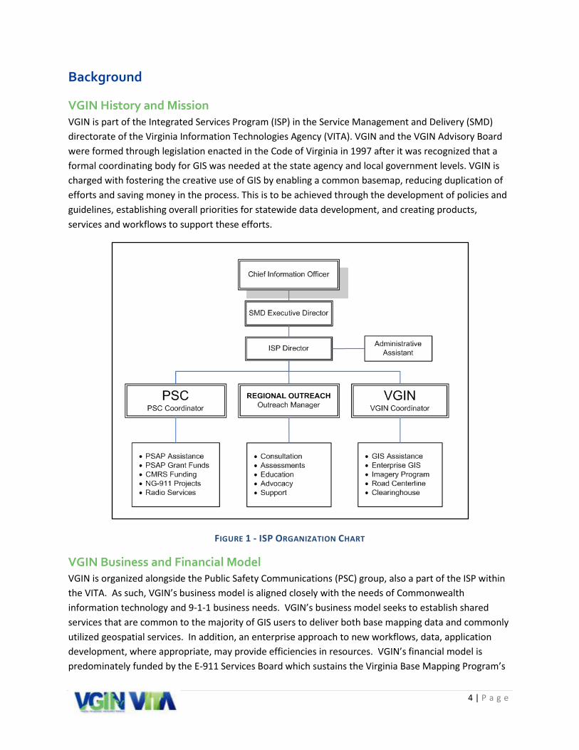
VGIN History and Mission VGIN is part of the Integrated Services Program (ISP) in the Service Management and Delivery (SMD) directorate of the Virginia Information Technologies Agency (VITA). VGIN and the VGIN Advisory Board were formed through legislation enacted in the Code of Virginia in 1997 after it was recognized that a formal coordinating body for GIS was needed at the state agency and local government levels. VGIN is charged with fostering the creative use of GIS by enabling a common basemap, reducing duplication of efforts and saving money in the process. This is to be achieved through the development of policies and guidelines, establishing overall priorities for statewide data development, and creating products, services and workflows to support these efforts.
FIGURE 1 - ISP ORGANIZATION CHART
VGIN Business and Financial Model VGIN is organized alongside the Public Safety Communications (PSC) group, also a part of the ISP within the VITA. As such, VGIN’s business model is aligned closely with the needs of Commonwealth information technology and 9-1-1 business needs. VGIN’s business model seeks to establish shared services that are common to the majority of GIS users to deliver both base mapping data and commonly utilized geospatial services. In addition, an enterprise approach to new workflows, data, application development, where appropriate, may provide efficiencies in resources. VGIN’s financial model is predominately funded by the E-911 Services Board which sustains the Virginia Base Mapping Program’s
5 | P a g e
orthophotography and road centerline maintenance programs. The WSB recognized the value of this data being centrally managed and maintained for the benefit of 9-1-1, as well as the greater good of the Commonwealth.
VGIN Products and Services VGIN’s products and services are comprised of two main areas, application and data services. Under application services, VGIN provides geospatial project management, geospatial application hosting, geospatial needs assessment, and consulting. Under data services, VGIN provides enterprise orthophotography and road centerline base mapping, enterprise geospatial web portal, enterprise base mapping web map services, and other enterprise base mapping data coordination.
Purpose of the GIS Strategic Plan 5 Year Update The Strategic Plan for VGIN defines strategic goals and initiatives to enhance geospatial functionality, services, and strategy in the Commonwealth. The Strategic Plan will chart a path toward an interoperable geospatial environment for the Commonwealth, using effective coordination, collaboration, communication, and creative services. This plan updates the 2010-2015 Strategic Plan and seeks to address emerging trends, challenges, and opportunities so that VGIN can remain a leader in the geospatial community over the next five years.
Through VITA’s contracting process, VGIN selected Michael Baker International (Baker) to provide GIS Strategic Planning services. Baker staff facilitated the Town Hall meetings, conducted the stakeholder interviews and online survey. With this comprehensive base of information, combined with Baker and VITA staff subject matter expertise input, Baker prepared the draft and final documents for approval by the VGIN Advisory Board.

6 | P a g e
GIS Strategic Plan 5 Year Update
Planning Approach and Methodology As a state agency that provides unique geospatial services to its clients, VGIN’s work and the overall work of the geospatial community at large are intertwined and interdependent. The strategic planning process has been a joint effort of VGIN and its many diverse stakeholders. GIS stakeholders include the VGIN Advisory Board, VGIN staff, local government, state government, federal government, planning district commissions (PDCs), non-governmental organizations (NGOs), public safety, academia, the private sector, and the general public. The strategic planning approach has been one that is stakeholder-driven and rooted in data collection and analysis.
Extensive information was collected and analyzed concurrently through a combination of methods that are shown in the diagram below.
FIGURE 2 – THE PLANNING PROCESS AND STAKEHOLDER OUTREACH
Review existing plan and surveys
Meetings with VGIN
staff
Regional town hall meetings
and statewide webinar
One-on-one stakeholder interviews
Online stakeholder
survey
Public comment
period

7 | P a g e
Acronyms and Key Terms 3D Elevation Program (3DEP)
A national program with a goal to systematically collect enhanced elevation data in the form of high-quality light detection and ranging (LIDAR) data over the conterminous United States, Hawaii, and the U.S. territories, with data acquired over an 8-year period.
Association of Public-Safety Communications Officials (APCO)
APCO is an organization of public safety communications professionals committed to providing complete public safety communications expertise, professional development, technical assistance, advocacy and outreach.
Authoritative Boundary The Authoritative Boundary represents the geographic area within which a given 9-1-1 Authority is responsible for providing and maintaining data for use in an ECRF/LVF.
Federal Geographic Data Committee (FGDC)
The Federal Geographic Data Committee (FGDC) is an interagency committee that promotes the coordinated development, use, sharing, and dissemination of geospatial data on a national basis.
Geographic Information Systems (GIS)
Geographic Information Systems is the broad term that refers to any number of different technologies, processes, and methods that analyze spatial information.
Integrated Services Program (ISP)
An area of the Virginia Information Technology Agency (VITA) comprising three service units including the Virginia Geographic Information Network (VGIN) Division, Public Safety Communications (PSC) Division, and the ISP Regional Outreach Program.
ISP Regional Outreach Program
The ISP Regional Outreach Program provides a common outreach effort for both the VGIN and PSC divisions since many efforts impact both services.
ISP Regional Coordinator (Regional Coordinator)
Through the Integrated Services Program’s (ISP) Regional Outreach Program, seven regional coordinators are available to the localities to assist with E-911 and GIS.
LiDAR Light Detection and Ranging (LiDAR) technology uses pulses of laser light to measure range or other information about distant targets.
National States Geographic Information Council (NSGIC)
NSGIC's Mission is to promote statewide geospatial coordination activities in all states and to be an effective advocate for states in national geospatial policy and initiatives, thereby enabling the National Spatial Data Infrastructure (NSDI).
National Emergency Number Association (NENA)
NENA serves the public safety community as the only professional organization solely focused on 9-1-1 policy, technology, operations, and education issues.
Next Generation 9-1-1 (NG911)
Initiative aimed at updating the 9-1-1 service infrastructure to improve public emergency communications services in an increasingly wireless mobile society.
Open Data Open data is the concept that certain acquired datasets should be free and available to the public.
Public Safety Answering Point (PSAP)
A public-safety answering point (PSAP), sometimes called "public-safety access point", is a call center responsible for answering calls to an emergency telephone number for police, firefighting, and ambulance services.
8 | P a g e
Public Safety Communications (PSC)
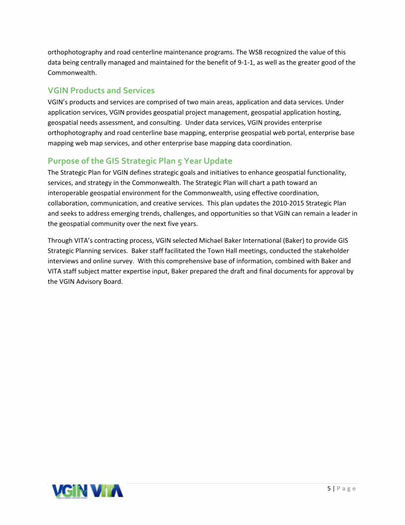
The Code of Virginia (§2.2-2031) establishes that the PSC Division "shall provide staff support to the Wireless E-911 Services Board and encourage, promote, and assist in the development and deployment of statewide enhanced emergency telecommunications systems."
Road Centerlines (RCL) Program
The Road Centerline (RCL) provides a consistent and seamless statewide digital dataset of all roads in the Commonwealth of Virginia.
Virginia Base Mapping Program (VBMP)
The VBMP mission is to acquire statewide orthophotography, mission critical data, and core data for Virginia.
Virginia Geographic Information Network (VGIN)
The Code of Virginia (§2.2-2026) establishes that the VGIN Division "shall foster the creative utilization of geographic information and oversee the development of a catalog of GIS data available in the Commonwealth."
Virginia Information Technologies Agency (VITA)
The Commonwealth's consolidated information technology organization.
Wireless E-911 Services Board
The Wireless E-911 Services Board (Wireless Board) consists of 9-1-1 community experts and leaders from the public and private sectors and provides information on the state of wireline, wireless, and NG 9-1-1 capabilities across the Commonwealth.
9 | P a g e
VGIN 2015-2020 Goals and Strategic Initiatives The 2015-2020 Strategic Plan culminates in the update of the Vision, Goals, Initiatives and Tasks for the coming five years. As part of this process, the existing goals and initiatives were closely evaluated for relevancy to the current update. Where appropriate, they have been re-written to reflect the new conditions and priorities of the coming five years. In addition, a detailed and expanded task list has been developed to support the deployment of each initiative.
The 2015-2020 Vision, Goals, and Initiatives are provided in detail below.
Vision The Vision statement developed for the 2010-2015 GIS Strategic Plan remains unchanged. It was the consensus opinion that it accurately reflects the Commonwealth’s mission:
Using geographic knowledge to create a better Virginia
Goal 1 - Coordination and Collaboration: Provide greater coordination and facilitate collaboration to refine VGIN’s role as it pertains to the geospatial and public safety communities throughout the Commonwealth.
Initiative 1: Perform coordination and collaboration between VGIN, Public Safety Communications, and the Regional Outreach Program.
Description The three service units of the Integrated Services Program (VGIN, PSC, and the Regional Outreach Program) each have a set of ultimate clients and business objectives. Primarily, PSC serves the PSAP community, VGIN serves the GIS community, and the Regional Outreach Program serves both. As such, VGIN and the PSC each have different missions and deliverables. However, the Commonwealth’s successful migration to NG911 represents an example of a joint mission that requires in-depth coordination between both the geospatial and public safety communities. The ultimate success of this mission requires a new level of coordination and collaboration between all three service units.
The need to improve VGIN’s coordination with PSC staff and ISP Regional Coordinators was listed as a “High Level Recommendation” in the previous five year plan and is re-emphasized in this document. Since much of the ISP (including VGIN) is funded through the Wireless E-911 Fund, a focus on public safety goals and objectives should be a fundamental priority for VGIN. However, as both geographic information technologies and public safety technologies can become highly specialized, it is not easy to establish where and how these technologies best complement each other. Therefore, a mutual understanding of mission and business workflows must be established through frequent and consistent communication and collaboration in order to achieve success for this initiative.
10 | P a g e
Outcomes • Refined responsibilities for management and staff within VGIN, PSC, and Regional Outreach
Program. • Comprehensive understanding of the role of geospatial data in public safety software solutions
and the impacts this has upon local GIS resources. • Serve as information resource for the PSC and for the PSAP and GIS communities regarding the
upcoming impacts of NG9-1-1. This includes outreach to lawmakers and other government officials.
Initiative Tasks • Review and refine responsibilities of ISP management and staff in all three service areas based
on new priorities for the next five years. o Continue weekly ISP management and staff meetings in all three service areas. o Continue quarterly work planning meetings with VGIN management, PSC management,
and the ISP regional coordinators. o Create a joint VGIN/PSC listserv to communicate with stakeholders on topics of mutual
concern. • Attend and participate in educational and conference activities that are of mutual interest for
VGIN, PSC, and the Regional Outreach Program. • Purposeful and consistent interaction and coordination with local GIS and local PSAP Managers
by Regional ISP Coordinators. • Coordinate with ISP staff on drafting a deployable outreach message to lawmakers and
government officials on the specific importance of supporting the needed GIS resources at the local government level.
Initiative 2: Perform coordination and collaboration between VGIN and Local Government
Description The local government (city/town, county, and Planning District Commissions) geospatial community represents a large and diverse set of VGIN’s customers. While VGIN does serve many different entities, the success of VGIN programs and initiatives relies on the participation and cooperation of the local government community. VGIN’s products and services are designed, primarily, with local government specifications in mind. Therefore, targeted coordination and collaboration between VGIN and local government stakeholders will ensure that the Commonwealth’s priorities are addressed by initiatives that best combine the resources and capabilities at the local level with those at the state level.
The town hall meetings conducted across the state as part of this strategic planning effort were well attended and effective. The participants were interested and motivated to help VGIN achieve its Vision: “Using geographic knowledge to create a better Virginia.” This type of effective outreach can be repeated on a more frequent basis, not just every five years. In addition, the Regional Coordinators are currently under-utilized by VGIN and are a resource that can support expanded coordination and collaboration on geospatial initiatives at the regional level.

11 | P a g e
Outcome • Improved alignment of VGIN products and services to the needs of local government customers. • More consistent delivery of products and services to VGIN’s ultimate customer, the
Commonwealth’s citizens. • Increased coordination between locality public safety and GIS staff. • Increased coordination between local initiatives within each region. • More in-depth knowledge of the role GIS plays in public safety communications systems, the
steps a jurisdiction will take to get their data ready, and the requirements needed to maintain the high-quality data.
Tasks • Provide a recurring webinar forum as a communication channel for local government
stakeholders. o Provide updates and seek input regarding current tasks and next priorities. o Seek updates from localities on special projects and initiatives that have relevance at
the Commonwealth level. • Direct and support the ISP regional coordinators in the implementation of smaller regional
groups of GIS stakeholders. The Town Hall meetings were very successful and this practice should be continued as appropriate at the different regions.
o Provide a forum to discuss stakeholder issues associated with supporting public safety communications GIS with the goal of identifying common technical issues and best practices.
o Provide a forum to discuss stakeholder issues associated with supporting local and regional GIS with the goal of identifying common technical issues and best practices.
• Increase knowledge and information sharing of regional initiatives in order to avoid duplication of effort and to share lessons learned with neighboring states.
o Encourage local attendance at VGIN Advisory Board meetings. o Allow for local government presentations to the Advisory Board on local and regional
projects and initiatives. • Upgrade and improve the ISP website in order to provide an improved web experience for ISP
service areas, products and services. o Re-purpose the website as a channel to highlight GIS and Public Safety successes at the
local level. • Expand the use of social media (Facebook, Twitter, etc.) to reach a broader audience and
provide additional communication channels.

12 | P a g e
Initiative 3: Perform coordination and collaboration between VGIN and State Agencies
Description The second largest group of VGIN customers is the geospatial staff that operates within other state agencies. These agencies include but are not limited to the Virginia Department of Emergency Management (VDEM), Virginia Department of Transportation (VDOT), Virginia Economic Development Partnership (VEDP), Virginia Outdoors Foundation (VOF), and the Department of Conservation and Recreation (DCR), Virginia Department of Forestry (DOF), Virginia Department of Game and Inland Fisheries (VDGIF), Virginia Department of Environmental Quality (DEQ) Department of Mines, Minerals, and Energy (DMME), Virginia Department of Health (VDH), along with State and Community Colleges and Universities. In addition, there are several state agencies that have a public safety function that require interaction with GIS, such as Virginia State Police (VSP), VDGIF, and DOF. Each of the state agencies has different goals and objectives, business workflows, data requirements, and a different set of ultimate clients.
Virginia state agencies have a need for more cohesive and comprehensive statewide datasets that can be used by other state agencies. Also, state agencies have a wealth of business data that is not currently stored in spatial files. By coordinating with different state agencies, VGIN can help agency staff identify how spatially enabling the data can be beneficial. At the same time, VGIN can leverage the talented staff and existing applications at the agency level to improve customer service at all levels.
Outcome • Improved alignment of VGIN products and services to the needs of state agency customers. • Identification of datasets that can be geospatially enabled. • Improved synergy of all geospatial applications and services that are provided by the
Commonwealth. Tasks
• Continue formal, quarterly outreach (conference call, webinar, or on-site meeting) to state agency stakeholders to provide a forum for discussion and feedback. VGIN is the GIS lead for the Commonwealth and can provide support and guidance to reduce duplication and improve efficiency across all of the agency GIS projects.
o Identify and catalogue the key GIS data by Agency. o Identify areas of commonality and potential opportunities for cooperation and
coordination. o Promote creative GIS initiatives being implemented by other agencies. o Encourage state agency attendance at VGIN Board meetings.
• Educate state agencies on NG9-1-1, the associated VGIN initiatives, and the potential implications for agency business workflows.
o Organize a workshop with relevant state agencies to discuss NG9-1-1. Identify how NG9-1-1 initiatives can be leveraged across the state to support public safety.

13 | P a g e
• Develop a list of basic data standards that requires data to be provided in a way that can be used by other state agencies.
• Develop a list of data that state agencies require from localities and work toward providing access to this data through the geospatial clearinghouse.
• Work with state agencies to identify opportunities for spatially enabling business data. o Identify critical agency datasets that are not currently available on the VGIN
Clearinghouse. • Upgrade and improve the ISP website in order to provide an improved web experience for VGIN
and Public Safety products and services.* o Re-purpose the website as a channel include GIS and Public Safety successes at the state
level. • Expand the use of social media (Facebook, Twitter, etc.) to reach a broader audience and
provide additional communication channels.*
*These tasks support multiple initiatives and are repeated

14 | P a g e
Initiative 4: Perform coordination and collaboration between VGIN and academia, non-profit, private sector, federal, and other GIS stakeholders
Description In addition to local governments and state agencies, there is a wide community of GIS stakeholders that comprise educational institutions, non-profit organizations, the private sector, and federal agencies. This community represents a wealth of GIS knowledge, data, products, and experience that provides opportunities for VGIN to form partnerships for shaping GIS in the Commonwealth.
Outcome Through coordination and collaboration with these stakeholders, VGIN will be able to:
• Increase knowledge and understanding of GIS initiatives in the Commonwealth outside of local governments and state agencies.
• Leverage opportunities for partnerships in geospatial data collection and application development.
• Improve alignment of VGIN products and services to the needs of GIS stakeholders outside of local governments and state agencies.
• Help shape the GIS Educational components and competencies for future GIS stakeholders. Tasks
• Consider options, where possible, for contracting with the private sector and/or educational institutions for data collection, data maintenance, and application development.
o Provide a forum for private sector and education institutions to showcase GIS projects and applications.
o Encourage private sector and educational institutions to present to the Advisory Board. • Work with the private sector to review and discuss procurement policies, procedures, and other
areas of mutual interest. • Encourage active participation in professional organizations including VAMLIS, VACO, URISA,
NSGIC, MAPPS, etc. • Upgrade and improve the ISP website in order to provide an improved web experience for VGIN
and Public Safety products and services.* o Re-purpose the website as a channel to highlight GIS and Public Safety successes.
• Expand the use of social media (Facebook, Twitter, etc.) to reach a broader audience and provide additional communication channels.*
• Work with educational institutions to help refine core competencies required for a career in the geospatial industry. *These tasks support multiple initiatives and are repeated
15 | P a g e
Goal 2 - Technical Services and Products: Provide and maintain statewide datasets and spatial solutions that are most efficiently and effectively managed at the state level.
Initiative 5: Provide NG9-1-1 Geospatial Data Products and Services
Description Based upon feedback garnered from the town hall sessions, the survey, and thought leader interviews there are key areas where VGIN can support the geospatial community as they move towards NG9-1-1. Jurisdictions are at the varying stages of getting prepared to support a NG9-1-1 system. Some are at advanced stages, some have not even started. The top priority will be to get all localities on a level playing field. A common set of NG9-1-1 products and services will standardize and facilitate the adoption of this important technology workflow across the Commonwealth.
Outcome • Boilerplate GIS requirements content for local governments to leverage in their procurement
documents (RFP). • An ISP supported data collection workflow or solution that enables the authoritative local
jurisdiction data to be collected and coalesced into a single database standard aligned with the NENA NG9-1-1 GIS Data Model recommendations.
• An ISP supported workflow or solution that will identify errors in the local authoritative data, enable them to address the errors (maintain authority) and maintain the quality control on this statewide dataset. This workflow should be closely aligned with the NENA NG9-1-1 GIS standards.
• An ISP supported workflow or solution that will expose access to the NG9-1-1 statewide datasets through download or data feed that is closely aligned with the NENA NG9-1-1 standards.
Tasks • VGIN, PSC and Regional Outreach Program education on the data specifications needed to
support a NG9-1-1 solution. • VGIN staff to coordinate with the PSC and Regional Outreach Program staff to develop a NG9-1-
1 GIS roadmap for 2015-2020 that meets the needs of both local stakeholder groups. • VGIN to work with the PSC and Regional Outreach Program staff on producing content for GIS
requirements that local governments can leverage for procurement documents. • The RCL, Address Point, Administrative Boundary and any other impacted VGIN data programs
need to be reengineered to meet the accuracy, authority and access requirements for NG9-1-1. • VGIN to work with the ISP staff on building/procuring a solution that:
o Accepts and coalesces disparate local authoritative GIS data that supports a E9-1-1 or NG9-1-1 system.

16 | P a g e
o Subjects this data to stringent quality control measures and provides detailed reports to these data authorities as to where the errors need to be addressed (either through editing or being marked as exception).
o Coalesces updates of the data and quality control workflows in a near real-time fashion. o Produces access to the statewide data for download or in a feed to meet the needs of
the individual 9-1-1 local solutions.
Initiative 6: Oversee the maintenance and advertising of a geospatial clearinghouse
Description The geospatial clearinghouse is intended to provide an easy and convenient access point for finding, accessing, and sharing geospatial data, services, links, and tools to support the Commonwealth. In order to be successful, the clearinghouse must effectively leverage existing federal, state agency, and local government GIS portal efforts.
The accuracy of the data in the clearinghouse is the ultimate responsibility of the authoritative data owners; however recommendations for best practices on metadata will be included to help ensure users understand the purpose and status of the datasets.
Outcome • An effective medium for providing access to the geospatial clearinghouse. • Identification of data sets that should be accessible from the geospatial clearinghouse. • Standards for how data is stored, exchanged and updated through the geospatial clearinghouse. • A current and effective geospatial clearinghouse that meets the needs of the Commonwealth.
Tasks • Evaluate and modify as needed the technology supporting the existing Data Clearinghouse to
ensure it meets the current and future needs of the Commonwealth. • Expand the specific datasets in the Commonwealth that should be accessed through the
Clearinghouse for future needs such as NG9-1-1. • Establish standards for the formats in which datasets will be stored, exchanged, and updated
through the geospatial clearinghouse. • Outline best practices for basic metadata requirements. • Conduct outreach to state and local government GIS departments to identify opportunities to
link to other geospatial portals and explain the benefit of the geospatial clearinghouse. • Continue to provide training to state and local government GIS departments on how to use the
clearinghouse and how to make data available. • Conduct an annual evaluation of the clearinghouse to ensure that it continues to meet
stakeholder needs.
17 | P a g e
Initiative 7: Provide Statewide Data Layers
Description Developing and maintaining statewide data layers through the Virginia Base Mapping Program (VBMP) continues to be the most popular and economically valuable service currently being provided by VGIN. The Town Hall meetings, stakeholder interviews, and the on-line survey confirmed that a vast majority of participants favor a continuation of this program. VGIN will continue the VBMP and expand it to additional statewide data layers including mission critical data to support NG9-1-1 as appropriate.
The statewide orthophotography contract under the VBMP is relied upon as a consistent and dependable source of ortho imagery for local and statewide use. VGIN will take these considerations into account as preparations begin for the release of the next RFP in 2016.
The statewide Road Centerline (RCL) dataset is maintained using data sourced from local data authorities and Virginia Department of Transportation. Although the RCL has been useful for supporting statewide and regional projects in the past, the current dataset and workflow methodology will not meet the level of accuracy required to support the implementation of NG9-1-1. Based upon the recommendations in the upcoming release of the NENA NG9-1-1 GIS Data Model, a reengineering of the RCL program will be required. This program will need to be renamed to reflect the data and workflows it will include to support the needs of the emergency communications user base. The data produced from this program will support the NG9-1-1 solution identified in a prior section (Goal 1, Initiative 5). That solution in conjunction with the VBMP data will provide needed inputs to the NG9-1-1 components implemented at the state or local levels.
Currently the VBMP is a general program to identify the base mapping data supported by VGIN. However, with the expanding requirements of NG9-1-1, Lidar and other core data there is a need to create subgroups of the program. These groupings will be identified as mission critical data (in support of public safety), orthophotography and core data. Each of these groups will require an identification of a VGIN staff member to be responsible for its coordination.
Outcome • Formalized sub-structure of the VBMP to include a delineation between Mission Critical data,
Core data, and Orthophotography. • A reengineered RCL program to be aligned with the Mission Critical data sub-program. • Continued production and improvement of statewide orthophotography. • Continued support of statewide contracting mechanisms for purchasing geospatial imagery
products and services. • Continued support of data collection projects for statewide LiDAR, Elevation and Land Cover. • Continued support of web services for VGIN data layers and the geocoding service. • Additional statewide core data layers as appropriate.

18 | P a g e
Tasks • Establish a stakeholder driven committee for the statewide data layers. • Divide the VBMP into three separate functional units that support datasets for Mission Critical
data, Core data, and Orthophotography. o Mission Critical
Expand the VBMP to support the collection, conflation, and dissemination of data layers required and recommended to support NG9-1-11
• Required data layers o Road Centerlines o PSAP Boundaries2 o Emergency Services Boundaries (this includes the Emergency
Services Boundaries for Police, Fire, EMS and any other as needed specifically for Commonwealth localities)3
o Authoritative Boundaries4 • Strongly Recommended data layers
o Road Name Alias Tables o Site / Structure Address Points o States or Equivalents Boundaries o Counties or Equivalents Boundaries o Municipal Boundaries o Cell Site Sector Locations
o Orthophotography Continue to provide orthophotography for the Commonwealth and evaluate
new imagery resources as technology advances. Evaluate the implementation of imagery provisioning service to share
orthophotography.
1 Information obtained from the GIS Data Model for NG9-1-1 document developed by NENA 2 Per the NENA GIS Data Model for NG9-1-1 draft, “This layer depicts the polygon boundary that defines the geographic area of a PSAP which has primary responsibilities for an emergency request. A geographic location can only have one designated primary PSAP. This layer is used by the ECRF to perform a geographic query to determine to which PSAP an emergency request is routed.” 3 Per the NENA GIS Data Model for NG9-1-1 draft, “An Emergency Service Boundary Layer defines the geographic area for the primary providers of response services. This layer is used by the ECRF to perform a geographic query to determine which Emergency Service provider is responsible for providing service to a location. In addition, Emergency Service Boundaries are used by PSAP’s to identify the appropriate entities/first responders to dispatch.” 4 Per the NENA GIS Data Model for NG9-1-1 draft, “The Authoritative Boundary represents the geographic area within which a given 9-1-1 Authority is responsible for providing and maintaining data for use in an ECRF/LVF. A given 9-1-1 Authority may provide authoritative GIS data for its entire content, the entirety of one layer, or a set of elements within a layer.”
19 | P a g e
Continue to provide access to statewide contracts for purchasing geospatial imagery products and services.
o Core Continue to support statewide data collection programs. Continue to support the geocoding service. Continue to support web services for Core data layers.
• Identify a product owner within VGIN for each of the three functional units who is responsible for the coordination, evaluation, and success of the data layers within the unit.
• Conduct annual evaluations of the data layers to ensure they continue to meet stakeholder needs.
• Reengineer the RCL program that includes: o New program name that better identifies the datasets it features o Continued collection of authoritative local centerline data o Continued collection of authoritative local address point data o Creation of and maintenance of PSAP boundary and authoritative boundary spatial
datasets detailed in the NENA NG9-1-1 GIS Data Model o Assess the need to collect and maintain a statewide emergency services boundaries
layer • Conduct outreach to the geospatial community to identify and prioritize additional data layers
for statewide creation and consumption and to determine what other statewide contracts would be beneficial for procurement of geospatial products and services.
20 | P a g e
Goal 3 - Education and Best Practices: Provide education and best practice resource opportunities that support increased technical capabilities and consistency of service across the Commonwealth.
Initiative 8: Define best practices and facilitate training opportunities that directly relate to the products and services generated by VGIN
Description Training and Best Practices continue to be a high priority for many participants in this effort. This is reflected in the discussion at the Town Hall meetings as well as in the online survey. “Provide educational opportunities” was the highest ranked priority for survey participants. This is not surprising as funding for training, conferences, and other educational opportunities is typically one of the first line items to be deleted during difficult budgetary times. This requires new and creative approaches to education that allows for an increased level of participation. VGIN can assist the geospatial community by serving as a central resource for information regarding training opportunities that are occurring across the state. In addition, VGIN can offer specific training relating to the existing products and services VGIN currently offers such as the base map data sets and the on-line services. For example, “How to do I use and analyze Lidar data?” is a topic that was raised at the Town Hall meetings.
Education and Best Practices specifically related to the VGIN’s role in deployment of NG9-1-1 is a high priority, and should be developed in support of Goal 2 listed above. These efforts need to be developed in joint partnership with PSC and the Regional Coordinators.
Outcome • Improved outreach and education campaign of the existence of VGIN products and services. • Increased awareness of training opportunities being offered across the state. • A supportive network of geospatial and public safety stakeholders. • An improved understanding of the products and services offered by VGIN.
Tasks • Facilitate specific educational opportunities on how to use data and services on VGIN supported
data and programs to include the VBMP data layers, the Data Clearinghouse portal, and the hosted web mapping services and applications.
• Host recurring webinars that highlight VGIN products and services. • Provide educational opportunities like focused webinars or specific classes on themes e.g. How
to obtain and use LiDAR data. • Update VGIN’s web presence to include a more user friendly website, easier access to products
and services, and up-to-date social media representation that promotes VGIN’s products, services, and vision as well as training opportunities.

21 | P a g e
Initiative 9: Serve as the “go-to” resource for Best Practice information relating to geospatial products and services as they are delivered by government entities across the Commonwealth
Description The size and level of expertise of GIS departments that serve local and state agencies varies widely across the Commonwealth. In fact, “GIS departments” typically only exist in the larger cities and counties. The majority of municipalities are only able to employ one or two GIS staff, and they can have a wide range of responsibilities. The 2011 Locality GIS Survey found that of the 118 locality responses, over 70% had 0-2 GIS staff. Apply typical staff turnover rates, and the result is that there is a great need for “Best Practice” information, especially as it relates to using GIS in smaller government settings.
For many geospatial business workflows (e.g. parcel maintenance, utility networks, work orders, etc.) best practices are established and can be provided through documentation or hands-on training. However, for NG9-1-1 as an example, geospatial best practices for data maintenance are far from clear. In fact, the recommended GIS Data Model for NG9-1-1 being developed by NENA is still in draft form. This emphasizes the need for VGIN to serve as a leader for all issues related to geospatial best practices. Localities across Virginia are deploying exciting and creative applications and services that can serve as examples for others to follow. By lifting these efforts up as examples, VGIN can support similar efforts across the state.
Outcome • Increased awareness of geospatial best practices at the local and state agency level. • Best practices identified for NG9-1-1. • Best practices for open data.
Tasks • Provide a platform to highlight geospatial best practice examples across the state. • Serve as a local government resource and advocate. • Leverage Regional Coordinators for one-on-one interaction with localities and state agencies to
understand areas of need. • Continue to encourage state and local governments to make data open and accessible to be
compliant with Open Data initiatives. • Update VGIN’s web presence to include a more user friendly website, easier access to products
and services, and up-to-date social media representation that promotes geospatial best practices.
22 | P a g e
Conclusion The strategic planning process for the next five years does not end with the publishing of this document. The 2015-2020 GIS Strategic Plan should be a living document that is updated on a periodic basis. In fact, the town hall meeting process was so successful that some recommended that it be repeated each year. While this is not practical, the desire is understood. The stakeholder outreach process generated productive discussion about the challenges facing the Commonwealth. More importantly, how these challenges can be met through a partnership between VGIN and its stakeholders. As these programs grow and evolve, they will need to be revisited on a regular basis to ensure that they are focused on meeting the goals as established in this plan.
23 | P a g e
Appendix A: The Code of Virginia Establishing VGIN’s Existence and Mandate
§ 2.2‐2025. DEFINITIONS. As used in this article, unless the context requires a different meaning:
"Base map data" means the digitized common geographic data that are used by most geographic information systems applications to reference or link attribute or other geographic data.
"Division" means the Geographic Information Network Division.
"Geographic data" means data that contain either coordinates that reference a geographic location or area or attribute data that can be related to a geographic area or location.
"Geographic information system (GIS)" means a computerized system that stores and links geographic data to allow a wide range of information processing and display operations, as well as map production, analysis, and modeling.
§ 2.2-2026. GEOGRAPHIC INFORMATION NETWORK DIVISION ESTABLISHED. There is established within VITA a Geographic Information Network Division (the Division), which shall foster the creative utilization of geographic information and oversee the development of a catalog of GIS data available in the Commonwealth. The Division shall be headed by a coordinator who shall be under the supervision of and report to the CIO. The Division shall exercise the powers and duties conferred in this article.
§ 2.2‐2027. POWERS AND DUTIES OF THE DIVISION; DIVISION COORDINATOR. A. The powers and duties of the Division shall include:
1. Requesting the services, expertise, supplies and facilities of VITA from the CIO on issues concerning the Division;
2. Accepting grants from the United States government and agencies and instrumentalities thereof and any other source. To those ends, the Division shall have the power to comply with such conditions and execute such agreements as may be necessary or desirable;
3. Fixing, altering, charging, and collecting rates, rentals, and other charges for the use or sale of products of, or services rendered by, the Division, at rates which reflect the fair market value;
4. Soliciting, receiving, and considering proposals for funding projects or initiatives from any state or federal agency, local or regional government, public institution of higher education, nonprofit organization, or private person or corporation;
5. Soliciting and accepting funds, goods and in-kind services that are part of any accepted project proposal;
6. Establishing ad hoc committees or project teams to investigate related technology or technical issues and providing results and recommendations for Division action; and
24 | P a g e
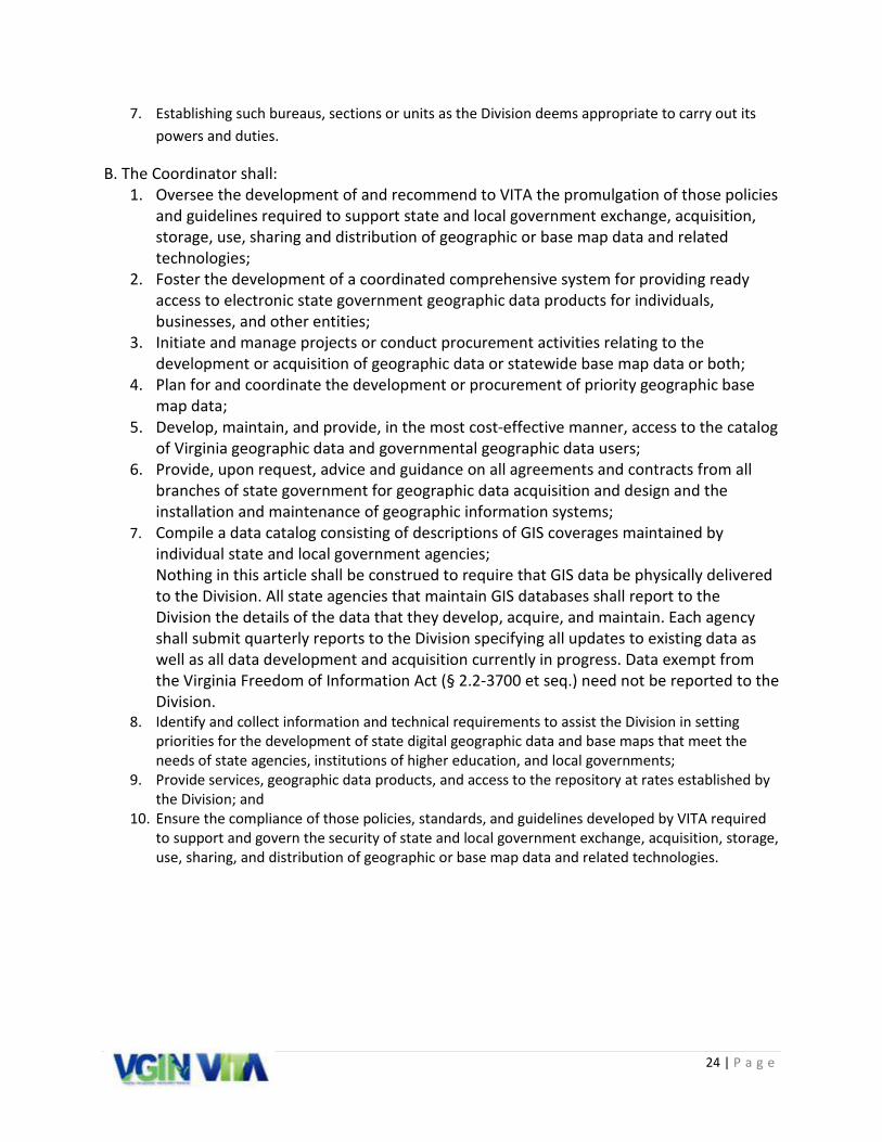
7. Establishing such bureaus, sections or units as the Division deems appropriate to carry out its powers and duties.
B. The Coordinator shall: 1. Oversee the development of and recommend to VITA the promulgation of those policies
and guidelines required to support state and local government exchange, acquisition, storage, use, sharing and distribution of geographic or base map data and related technologies;
2. Foster the development of a coordinated comprehensive system for providing ready access to electronic state government geographic data products for individuals, businesses, and other entities;
3. Initiate and manage projects or conduct procurement activities relating to the development or acquisition of geographic data or statewide base map data or both;
4. Plan for and coordinate the development or procurement of priority geographic base map data;
5. Develop, maintain, and provide, in the most cost-effective manner, access to the catalog of Virginia geographic data and governmental geographic data users;
6. Provide, upon request, advice and guidance on all agreements and contracts from all branches of state government for geographic data acquisition and design and the installation and maintenance of geographic information systems;
7. Compile a data catalog consisting of descriptions of GIS coverages maintained by individual state and local government agencies; Nothing in this article shall be construed to require that GIS data be physically delivered to the Division. All state agencies that maintain GIS databases shall report to the Division the details of the data that they develop, acquire, and maintain. Each agency shall submit quarterly reports to the Division specifying all updates to existing data as well as all data development and acquisition currently in progress. Data exempt from the Virginia Freedom of Information Act (§ 2.2-3700 et seq.) need not be reported to the Division.
8. Identify and collect information and technical requirements to assist the Division in setting priorities for the development of state digital geographic data and base maps that meet the needs of state agencies, institutions of higher education, and local governments;
9. Provide services, geographic data products, and access to the repository at rates established by the Division; and
10. Ensure the compliance of those policies, standards, and guidelines developed by VITA required to support and govern the security of state and local government exchange, acquisition, storage, use, sharing, and distribution of geographic or base map data and related technologies.

25 | P a g e
Appendix B: Planning Process and Stakeholder Outreach
Document Review
The following documents were reviewed as background material for this effort.2010-2015 GIS Strategic Plan The 2010-2015 GIS Strategic Plan was funded through the Federal Geographic Data Committee (FGDC) “50 States Initiative.” The FGDC grant was awarded to encourage implementation of statewide spatial data infrastructure, provide guidance on planning activities, encourage partnerships and alliances, and provide a uniform national framework for strategic and business plans.
2012 State Agency GIS User Survey In the summer of 2012, VGIN performed a survey of Commonwealth Agencies and Bodies about their use of GIS and mapping technologies. Results were presented at the 2012 Virginia GIS Conference and are available on the VGIN website: http://www.vita.virginia.gov/isp/default.aspx?id=12096
2011 Locality GIS Survey In the fall of 2011, VGIN sent out a Locality GIS Baseline Survey to gather information about the GIS capabilities and use of GIS services by Virginia’s localities. These survey results were reviewed for content and comparison with this current effort. Full results of this survey can also be found on the VGIN website: http://www.vita.virginia.gov/isp/default.aspx?id=12096
FIGURE 7 - 2010-2015 GIS
FIGURE 8 - 2012 STATE AGENCY SURVEY GRAPHIC
FIGURE 9 - 2011 LOCALITY SURVEY
26 | P a g e
Stakeholder Engagement
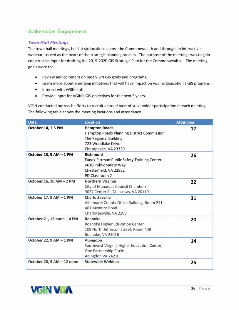
Town Hall Meetings The town hall meetings, held at six locations across the Commonwealth and through an interactive webinar, served as the heart of the strategic planning process. The purpose of the meetings was to gain constructive input for drafting the 2015-2020 GIS Strategic Plan for the Commonwealth. The meeting goals were to:
• Review and comment on past VGIN GIS goals and programs. • Learn more about emerging initiatives that will have impact on your organization's GIS program. • Interact with VGIN staff. • Provide input for VGIN's GIS objectives for the next 5 years.
VGIN conducted outreach efforts to recruit a broad base of stakeholder participation at each meeting. The following table shows the meeting locations and attendance.
Date Location Attendees October 14, 1-5 PM
Hampton Roads Hampton Roads Planning District Commission The Regional Building 723 Woodlake Drive Chesapeake, VA 23320
17
October 15, 9 AM – 1 PM Richmond Eanes-Pittman Public Safety Training Center 6610 Public Safety Way Chesterfield, VA 23832 PD Classroom 2
26
October 16, 10 AM – 2 PM Northern Virginia City of Manassas Council Chambers 9027 Center St, Manassas, VA 20110
22
October 17, 9 AM – 1 PM Charlottesville Albemarle County Office Building, Room 241 401 McIntire Road Charlottesville, VA 2290
31
October 21, 12 noon – 4 PM Roanoke Roanoke Higher Education Center 108 North Jefferson Street, Room 408 Roanoke, VA 24016
20
October 22, 9 AM – 1 PM Abingdon Southwest Virginia Higher Education Center, One Partnership Circle Abingdon VA 24210
14
October 28, 9 AM – 12 noon Statewide Webinar
25
27 | P a g e
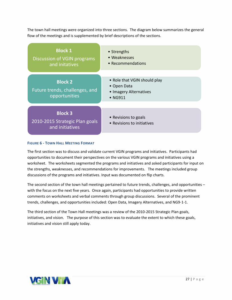
The town hall meetings were organized into three sections. The diagram below summarizes the general flow of the meetings and is supplemented by brief descriptions of the sections.
FIGURE 6 - TOWN HALL MEETING FORMAT
The first section was to discuss and validate current VGIN programs and initiatives. Participants had opportunities to document their perspectives on the various VGIN programs and initiatives using a worksheet. The worksheets segmented the programs and initiatives and asked participants for input on the strengths, weaknesses, and recommendations for improvements. The meetings included group discussions of the programs and initiatives. Input was documented on flip charts.
The second section of the town hall meetings pertained to future trends, challenges, and opportunities – with the focus on the next five years. Once again, participants had opportunities to provide written comments on worksheets and verbal comments through group discussions. Several of the prominent trends, challenges, and opportunities included: Open Data, Imagery Alternatives, and NG9-1-1.
The third section of the Town Hall meetings was a review of the 2010-2015 Strategic Plan goals, initiatives, and vision. The purpose of this section was to evaluate the extent to which these goals, initiatives and vision still apply today.
• Strengths • Weaknesses • Recommendations
Block 1 Discussion of VGIN programs
and initatives
• Role that VGIN should play • Open Data • Imagery Alternatives • NG911
Block 2 Future trends, challenges, and
opportunities
• Revisions to goals • Revisions to initiatives
Block 3 2010-2015 Strategic Plan goals
and initiatives
28 | P a g e
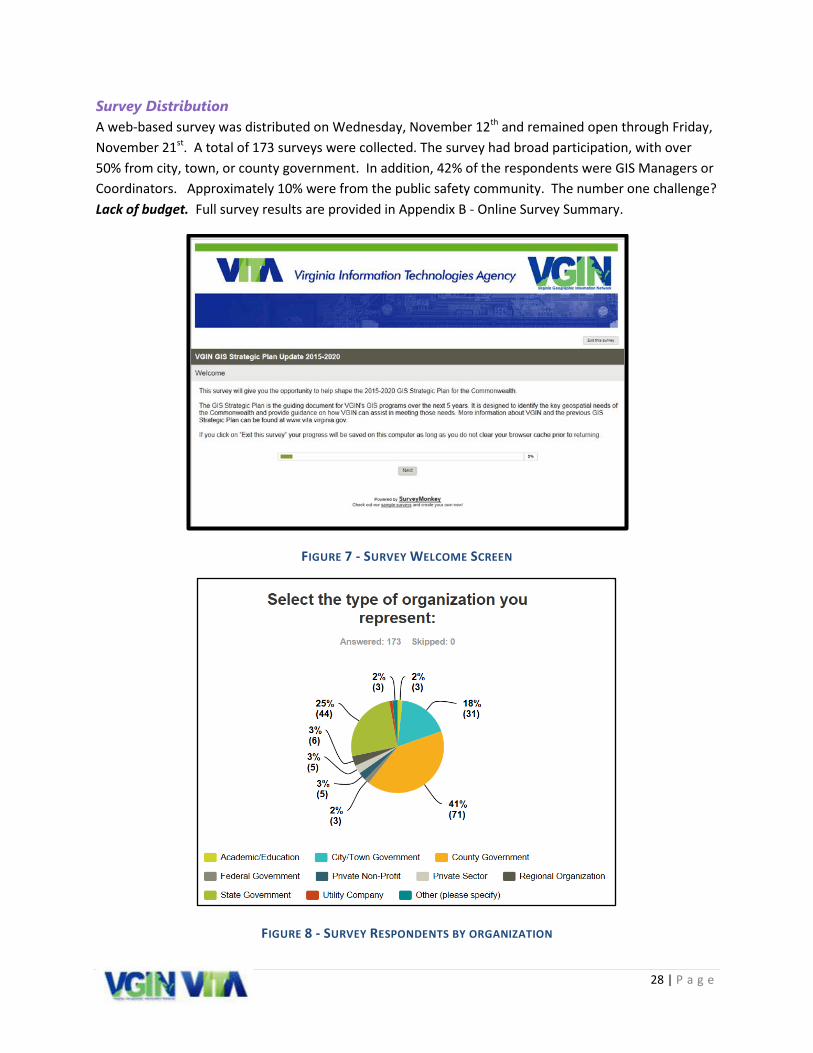
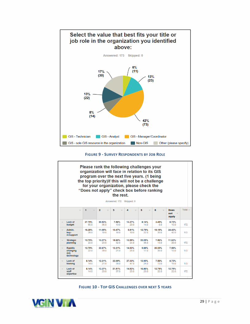
Survey Distribution A web-based survey was distributed on Wednesday, November 12th and remained open through Friday, November 21st. A total of 173 surveys were collected. The survey had broad participation, with over 50% from city, town, or county government. In addition, 42% of the respondents were GIS Managers or Coordinators. Approximately 10% were from the public safety community. The number one challenge? Lack of budget. Full survey results are provided in Appendix B - Online Survey Summary.
FIGURE 7 - SURVEY WELCOME SCREEN
FIGURE 8 - SURVEY RESPONDENTS BY ORGANIZATION
29 | P a g e
FIGURE 9 - SURVEY RESPONDENTS BY JOB ROLE
FIGURE 10 - TOP GIS CHALLENGES OVER NEXT 5 YEARS
30 | P a g e
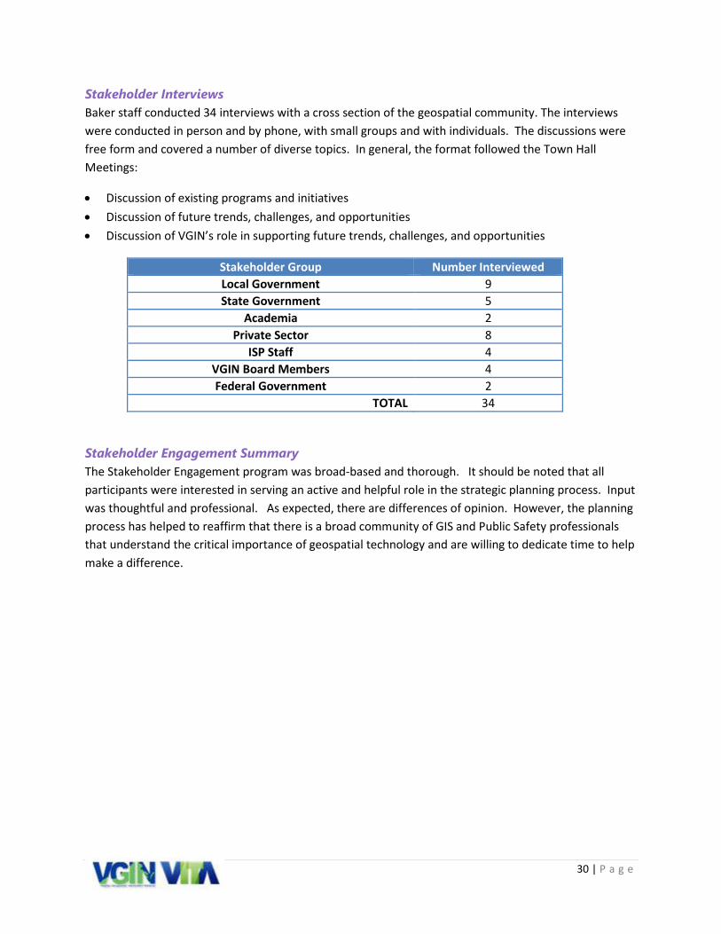
Stakeholder Interviews Baker staff conducted 34 interviews with a cross section of the geospatial community. The interviews were conducted in person and by phone, with small groups and with individuals. The discussions were free form and covered a number of diverse topics. In general, the format followed the Town Hall Meetings:
• Discussion of existing programs and initiatives • Discussion of future trends, challenges, and opportunities • Discussion of VGIN’s role in supporting future trends, challenges, and opportunities
Stakeholder Group Number Interviewed Local Government 9 State Government 5
Academia 2 Private Sector 8
ISP Staff 4 VGIN Board Members 4 Federal Government 2
TOTAL 34
Stakeholder Engagement Summary The Stakeholder Engagement program was broad-based and thorough. It should be noted that all participants were interested in serving an active and helpful role in the strategic planning process. Input was thoughtful and professional. As expected, there are differences of opinion. However, the planning process has helped to reaffirm that there is a broad community of GIS and Public Safety professionals that understand the critical importance of geospatial technology and are willing to dedicate time to help make a difference.

31 | P a g e
Appendix C: Stakeholder Input: Programs, Initiatives, and Challenges The following summary is based on feedback from the Town Hall meetings, interviews, and online survey.
VBMP Orthophotography The Virginia Base Mapping Program (VBMP) acquires statewide orthophotography on a four year cycle for Virginia. VBMP imagery was acquired in 2002, 2006/2007, 2009, and 2011. The orthophotography program was established to promote effective and economically efficient development and sharing of spatial resources across the Commonwealth. The Commonwealth of Virginia also sought to establish a consistent foundation or base map resource upon which local government spatial data, applications and GIS could be consistently developed and maintained. Virginia is now committed to sustaining this program through regular updates of the imagery which is provided to localities at no cost.
In 2013, the Commonwealth contracted with the Sanborn Map Company to provide full color, leaf-off, digital orthophotography for the entire land base of Virginia. The eastern portion of the State was acquired in Spring 2013, while the western portion will be reacquired in Spring 2016.
VBMP Orthophotography (Stakeholder input)
Strengths Weaknesses • No cost orthophotography provides
many localities with imagery they would not otherwise be able to afford
• Orthophotography is free and available to the public
• Orthophotography is required to meet specific accuracy standards
• Seamless statewide imagery that provides a common basemap for the commonwealth with a “one stop authoritative source”
• The tiling standards implemented for the VA orthophotography provides a consistent, usable format for statewide data
• Orthophotography is available as a map service
• Reliable schedule that allows localities to plan for data updates
• Statewide contracting mechanism that supports procurement for imagery upgrades and products
• Program is well defined and updates are communicated frequently and effectively
• The four-year collection cycle is not current enough for many urban and other developing areas
• The length of time required for post-processing is too long – imagery is close to a year old when released
• Imagery for areas along the border of the east/west collection path is collected in different years
• Recent imagery has had issues with shadows, tile shading, and missing or inaccurate tiles
• Recent imagery has developed a spatial shift
• Scale and resolution of the online map service is not high enough to support certain projects
• Imagery is not provided in an image service so it can only be used for visualization
• Minimum requirements for flying areas in off-years is too large and is cost prohibitive for most localities
• County-wide mosaics are not provided • Imagery is not used by mobile imagery

32 | P a g e
• VGIN provides QC support and management of imagery acquisition and maintenance
• VGIN staff is quick to resolve issues once they have been identified
providers (e.g., Google, Apple, Bing, etc.)
The VBMP Orthophotography is widely used and well accepted by most all stakeholders who participated in the strategic plan update process. Of the 10 respondents from the online survey who said they do not use the orthophotography, only two indicated that the accuracy and/or resolution of the product is insufficient to meet their business needs.
Of the 113 respondents who said they use the VBMP Orthophotography, more than 78% agree or strongly agree that the VBMP represents a cost savings to the organization and that it would be difficult for the organization to obtain orthophotography without the assistance of the VBMP.
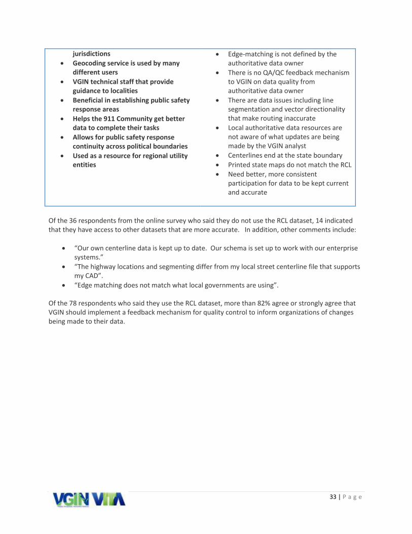
Road Centerline Program VGIN's Road Centerline (RCL) Team continues to work with locally provided data to create a statewide dataset. This product, provided quarterly, is the Commonwealth of Virginia's RCL GIS database with addressing, and is made available in both geodatabase and shapefile format. The RCL staff also serve as an important technical resource for participating localities. The primary users of the RCL are state agencies that do not maintain a road centerline file as part of their internal workflow (Over 70% of state agency respondents). In addition, the RCL is also used as a data source for some applications that require a regional street network.
However, results from the online survey suggest that the RCL is not used as much at the local government level. For city, county, and town respondents, approximately 45% do not use the RCL because it does not meet their needs. This is due to three primary challenges: 1) Participation in the RCL program is voluntary, and many localities do not submit data on a frequent basis. 2) Quarterly updates are not sufficient for most local government business needs. This is compounded by the fact that lack of program participation can result in some data being over a year old. 3) Those entities that do not use RCL are instead using an internally maintained road centerline file that meets existing schema, currency, and accuracy needs.
Road Centerline (Stakeholder input)
Strengths Weaknesses • Seamless statewide centerline dataset • Good resource for most geocoding
outside of individual jurisdictions • Data is collected from local authorities • Improves routability between
• Quarterly updates do not reflect the most current data
• The submission process for data updates is inefficient
• Too much time is spent modifying local authoritative data
33 | P a g e
jurisdictions • Geocoding service is used by many
different users • VGIN technical staff that provide
guidance to localities • Beneficial in establishing public safety
response areas • Helps the 911 Community get better
data to complete their tasks • Allows for public safety response
continuity across political boundaries • Used as a resource for regional utility
entities
• Edge-matching is not defined by the authoritative data owner
• There is no QA/QC feedback mechanism to VGIN on data quality from authoritative data owner
• There are data issues including line segmentation and vector directionality that make routing inaccurate
• Local authoritative data resources are not aware of what updates are being made by the VGIN analyst
• Centerlines end at the state boundary • Printed state maps do not match the RCL • Need better, more consistent
participation for data to be kept current and accurate
Of the 36 respondents from the online survey who said they do not use the RCL dataset, 14 indicated that they have access to other datasets that are more accurate. In addition, other comments include:
• “Our own centerline data is kept up to date. Our schema is set up to work with our enterprise systems.”
• “The highway locations and segmenting differ from my local street centerline file that supports my CAD”.
• “Edge matching does not match what local governments are using”. Of the 78 respondents who said they use the RCL dataset, more than 82% agree or strongly agree that VGIN should implement a feedback mechanism for quality control to inform organizations of changes being made to their data.

34 | P a g e
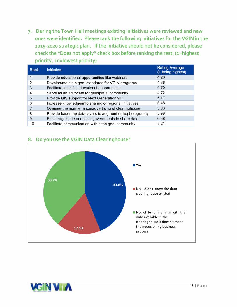
VGIN Data Clearinghouse VGIN hosts the Virginia GIS Clearinghouse, available on the web at: http://vgin.maps.arcgis.com . The Clearinghouse hosts data and metadata for Virginia datasets made available through state agencies, local governments, and others. Development and deployment of the Clearinghouse was an initiative of the 2010-2015 GIS Strategic Plan. There were 137 responents for the online question “Do you use the VGIN Data Clearinghouse?” Of these respondents, 38% did not use it because it did not meet their business needs and another 17% were unaware that it existed. The Clearinghouse does perform an important role as a central location for geographic information about Virginia. While “clearinghouse functionality” is not ncessarily part of the daily workflow for most organizations, it is clear that the Clearinghouse suffers from a lack of use due poor visibility and awareness.
Data Clearinghouse (Stakeholder input)
Strengths Weaknesses • Increases access to statewide
authoritative data • Clean and easy to use interface • Single source access for data • Web services as an alternative to
downloading data • Data is available to the public
• The Clearinghouse is hard to find on VGIN’s website and is not marketed very well
• There are not enough participants in the clearinghouse including both localities and state agencies
• There is a lack of data standards for data exchange
• There is not a clear indication of what data is available along with clear metadata describing what the data should be used for
• The currency of data is unknown • The Clearinghouse does not provide a
spatial search for data • Multiple versions of the same dataset
are available • The Clearinghouse is limited to Esri • The Clearinghouse does not link to all
existing ArcGIS Open Data sites for both localities and state agencies
FIGURE 15 - HOME PAGE
35 | P a g e
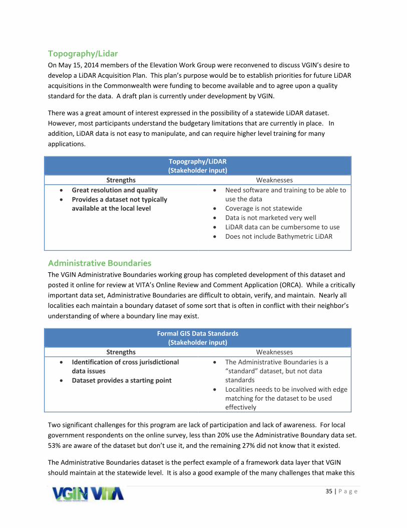
Topography/Lidar On May 15, 2014 members of the Elevation Work Group were reconvened to discuss VGIN’s desire to develop a LiDAR Acquisition Plan. This plan’s purpose would be to establish priorities for future LiDAR acquisitions in the Commonwealth were funding to become available and to agree upon a quality standard for the data. A draft plan is currently under development by VGIN.
There was a great amount of interest expressed in the possibility of a statewide LiDAR dataset. However, most participants understand the budgetary limitations that are currently in place. In addition, LiDAR data is not easy to manipulate, and can require higher level training for many applications.
Topography/LiDAR (Stakeholder input)
Strengths Weaknesses • Great resolution and quality • Provides a dataset not typically
available at the local level
• Need software and training to be able to use the data
• Coverage is not statewide • Data is not marketed very well • LiDAR data can be cumbersome to use • Does not include Bathymetric LiDAR
Administrative Boundaries The VGIN Administrative Boundaries working group has completed development of this dataset and posted it online for review at VITA’s Online Review and Comment Application (ORCA). While a critically important data set, Administrative Boundaries are difficult to obtain, verify, and maintain. Nearly all localities each maintain a boundary dataset of some sort that is often in conflict with their neighbor’s understanding of where a boundary line may exist.
Formal GIS Data Standards (Stakeholder input)
Strengths Weaknesses • Identification of cross jurisdictional
data issues • Dataset provides a starting point
• The Administrative Boundaries is a “standard” dataset, but not data standards
• Localities needs to be involved with edge matching for the dataset to be used effectively
Two significant challenges for this program are lack of participation and lack of awareness. For local government respondents on the online survey, less than 20% use the Administrative Boundary data set. 53% are aware of the dataset but don’t use it, and the remaining 27% did not know that it existed.
The Administrative Boundaries dataset is the perfect example of a framework data layer that VGIN should maintain at the statewide level. It is also a good example of the many challenges that make this

36 | P a g e
a difficult effort: awareness, local government coordination, as well as historical and political issues that must be overcome.
Outreach and Education Outreach and education was consistently a high priority for all stakeholders. In fact, the initiative “Provide educational opportunities like focused webinars or specific classes on themes” was ranked the highest priority across all stakeholders. Like all disciplines, GIS and Public Safety must manage a fair amount of staff turnover. This means that to some extent “organizational knowledge” is being lost on an annual basis. This is reflected in the survey by the number of respondents that are unaware of the existence of different programs. A consistent outreach and education program helps provide a level of continuity regarding resources that are available at the state, regional, and local level.
In addition to outreach to governmental stakeholders, outreach to the private sector must be considered as well. Many of VGIN’s products and services are contracted and developed by private sector firms. One area of concern identified by the private sector through the stakeholder interview process concerns VGIN’s procurement process. It was recommended that VGIN establish a formal liaison with the Board for Architects, Professional Engineers, Land Surveyors, Certified Interior Designers and Landscape Architects to discuss areas of interest.
One thing is certain: the town hall meeting and stakeholder involvement process confirmed that the Commonwealth has a broad base of skilled GIS and Public Safety professionals. This is VGIN’s greatest resource. The result is a partnership that can help advance the goals and initiatives that are included as part of this plan.
Outreach and Education (Stakeholder input)
Strengths Weaknesses • ISP coordinators and other VGIN staff
are great • “Phenomenal staff – extremely
responsive and go the extra mile.” • Newsletter • Listserv database
• Not all folks are aware of the ISP coordinator
• Website is a problem – the “face” of VGIN is lost in the VITA website
• Need more training resources and vehicles that can be leveraged to minimize cost
• Need to provide training on how to use data that is provided by VGIN
• Outreach to decision makers is lacking • Need information for “Best Practices” • GIS Virginia website was a good
resource, but is no longer used • No live training opportunities either in-
person workshops or Web meetings

37 | P a g e
“After touching on some of the new GIS requirements for Next Gen 911, I am concerned that our local government GIS staff is inadequate to meet the coming needs. Discussion with our IT department confirmed that the 1-3 day updates workflow turn-around will be nearly impossible to achieve.”
- Worksheet from Statewide Webinar
NG9-1-1 Next Generation 9-1-1 is an emerging technology for the GIS community. Across the different town hall meetings, few were able to answer the question, “What do I need to do to get my data ready for NG9-1-1?” The following requirements were highlighted during the question and answer portion of the town hall meetings:
• More timely data update cycle (recommendations range from 1 to 3 business days from when a GIS data error is identified to when it needs to be updated in the PSAP’s data)
• Process’ to elevate and maintain a high level of quality control on the spatial data
• Need for each jurisdiction to have access to the high quality data in a regional footprint.
The question of standards was also raised frequently, along with the need for guidance on the topic. The National Emergency Numbers Association (NENA) Core Services Committee is currently finalizing a Standard for NG9-1-1 GIS Data Model. While the model is still in draft form, it is necessary to build future recommendations to be closely aligned with these standards. The document does clearly state the NG9-1-1 GIS Data Model is a minimum set of standards and that each locality and state will likely need to adopt but also build a custom approach to fit the needs of the individual GIS and Public Safety Communications communities.
It is important to note that for GIS stakeholders, the data requirements will ultimately be defined by the software solution provider each local jurisdiction selects. This schema will almost certainly be different from locality to locality. Even though NENA is working on a standard, there is no policy that would force the solution providers to adhere to this approach. This poses an accommodation that must be met to not only translate the disparate source GIS data from each jurisdiction into a defined state model but to then expose the data to be accessed in a translation for the needs of the individual systems they will support.
While there are solutions on the market that can accommodate these issues, it’s also important to understand that each jurisdiction has other legacy business processes that the same spatial data supports. It’s important to impress the mission criticality of the 911 business process but also have a perspective that purposeful and careful planning will have to happen to make sure all systems can support these updated changes NG9-1-1 will force.

38 | P a g e
Next Generation 9-1-1 (Stakeholder input)
Strengths Weaknesses • Existing VGIN programs that collect
data from local GIS authorities have established a history of the statewide dataset model.
• Funding already allocated for VGIN data programs.
• Identified staff (ISP Regional Coordinators) who can support the needed outreach and coordination with the local GIS authorities.
• RCL, address point project and administrative boundary program do not meet the needs of public safety systems and will need to be reengineered to do so.
• Not enough cohesive direction from VGIN to the ISP Regional Coordinators as to the role they should be playing to the GIS stakeholders in their area.
• Lack of coordination between VGIN staff and the PSC group in the ISP division.
• VGIN does not have enough knowledge as to the impacts Next Generation 9-1-1 will have upon local GIS data and resources.
• No existing technical education or outreach program to educate the public and private stakeholders on the role GIS will play in Next Generation 9-1-1.

39 | P a g e
Appendix D: Online Survey Summary
1. Select the type of organization that you represent
Other: Retired Mapping Scientist 9-1-1 Center - PSAP Planning District
1.7%
17.9%
41.0%
1.7% 2.9% 2.9% 3.5%
25.4%
1.2% 1.7%
0.0%
5.0%
10.0%
15.0%
20.0%
25.0%
30.0%
35.0%
40.0%
45.0%

40 | P a g e
2. Select the value that best fits your title or job role in the organization you identified above:
Other: • GIS user • 9-1-1 Director • City IT • Architect • Planning Manager • Senior Policy Analyst and GIS Coordinator • IT Director & GIS Coordinator • Forester, Farmer • 911 Coordinator • GIS Specialist/Cartographer/Crime Analyst • 911 Coordinator/GIS(addressing) • Cad Mobile Administrator • Student mentor • CEO • Building / Planning & Zoning / GIS • Regional Manager • 911 Communications Supervisor • Regional Coordinator • 9-1-1 Center Executive Director • Hazard Mitigation Planner • PSAP Manager • Administration/Architecture • Environmental Planner--some GIS • Research Associate • GIS user for E911 • 911 Manager
6.4%
13.3%
42.2%
8.1%
12.7%
17.3%
GIS - Technician
GIS - Analyst
GIS - Manager/Coordinator
GIS - sole GIS resource in theorganizationNon-GIS
Other (please specify)

41 | P a g e
3. Did you attend a Town Hall Session?
4. Please rank the following challenges your organization will face in relation to its GIS program over the next five years. If this will not be a challenge for your organization, please check the “Does not apply” check box before ranking the rest. (1=highest priority, 6=lowest priority)
Rank Challenge Rating Average (1 being highest)
1 Lack of sufficient budget 2.39 2 Proper strategic planning 3.48 3 Rapidly changing GIS technology 3.52 4 Lack of training 3.53 5 Administrative buy-in/support 3.62 6 Lack of staff expertise 3.64
38.2%
61.8%
Yes No

42 | P a g e
5. Of the VGIN data programs listed below, which ones have you supplied data to be included?
6. Based upon the ISP Regions outlined above, have you interfaced with your corresponding regional coordinator in the past 12 months?
21.8%
45.8%
31.0%
38.7%
0.0%
5.0%
10.0%
15.0%
20.0%
25.0%
30.0%
35.0%
40.0%
45.0%
50.0%
Data Clearinghouse RCL AdministrativeBoundary
I have not suppliedany data for either ofthese three programs
60.6%
39.4%
Yes No
43 | P a g e
7. During the Town Hall meetings existing initiatives were reviewed and new ones were identified. Please rank the following initiatives for the VGIN in the 2015-2020 strategic plan. If the initiative should not be considered, please check the “Does not apply” check box before ranking the rest. (1=highest priority, 10=lowest priority)
Rank Initiative Rating Average (1 being highest)
1 Provide educational opportunities like webinars 4.20 2 Develop/maintain geo. standards for VGIN programs 4.66 3 Facilitate specific educational opportunities 4.70 4 Serve as an advocate for geospatial community 4.72 5 Provide GIS support for Next Generation 911 5.17 6 Increase knowledge/info sharing of regional initiatives 5.48 7 Oversee the maintenance/advertising of clearinghouse 5.93 8 Provide basemap data layers to augment orthophotography 5.99 9 Encourage state and local governments to share data 6.38 10 Facilitate communication within the geo. community 7.21
8. Do you use the VGIN Data Clearinghouse?
43.8%
17.5%
38.7%
Yes
No, I didn't know the dataclearinghouse existed
No, while I am familiar with thedata available in theclearinghouse it doesn't meetthe needs of my businessprocess

44 | P a g e
9. Please indicate the extent to which you agree or disagree with the following statements as they relate to your use of the Data Clearinghouse: (5=highest, strongly agree)
Rank Statement Rating Average (5 being the highest)
1 Encourage agencies to participate in Data Clearinghouse 4.32 2 The web services provide a strong benefit for accessing data 4.30 3 Provide links directly to agency website data 4.30 4 Provide GIS Best Practices for datasets 4.22 5 VGIN should provide a matrix with metadata 4.17 6 More participation from VA geospatial community 4.06 7 The web services are easy to access 4.02 8 Better advertise Data Clearinghouse 3.96 9 VGIN should provide schedule for data updates 3.96 10 The downloadable data files are easy to access 3.75
10. From the reasons listed below, how does the data in the clearinghouse not meet the needs of your business process?
24.1%
33.3% 37.0%
11.1%
50.0%
13.0%
0.0%
10.0%
20.0%
30.0%
40.0%
50.0%
60.0%
The interface fordownloading
data or findingservices is
difficult to use
I have access toother datasets
are moreaccurate and up
to date
These are notdataset(s) I use in
my businessworkflow
The data is not inthe format orschema that I
need for my tasks
I have heardabout the DataClearinghouse
but I don't use it
Other (pleasespecify)

45 | P a g e
Other Comments: I don't know how or if the clearinghouse could benefit our locality We have not explored it much yet. We intend to explore it more now that we have finally upgraded our GIS Software and are getting on board with ArcGIS Online and data and apps. We have a lot of our own very good data. We do contribute our own data to the Parcel, Address and RCL data that VGIN has.
Easy of use, availability
I have not made the time to use it. We are converting our data to an ESRI platform and I intend on using it once we have completed the conversion. Our locality sells our GIS Data. It's hard to find the Clearinghouse, first off. The VGIN website is notoriously difficult to navigate, and a Google Search is probably easier. When you do find the clearinghouse, it's hard to find the data you need. For example, say I want roads. On the clearinghouse home page, instead of a nice compact list of categories, there's this banner with huge icons I need to scroll through. So I scroll over to Virginia Transportation Data, click on it, and all I find there is VGIN Composite Geocoder. I don't want a geocoder, I want roads! Turns out that the REST service address it gives there does contain simple RCL data, but you wouldn't know it from the listing. Then if you do find the data you need, typically you can't even download it. If you're lucky, you find the REST service. Otherwise, you have to add it as a "portal item", whatever that is, or add it to a useless online map viewer. The general public may like online map viewers, but as a GIS analyst, I hate them. And the REST services, while fine for viewing, preclude any analysis. I can't export the data to a new feature class, can't select specific features by attributes or location, can't do any geoprocessing on them. It needs to be much easier to DIRECTLY DOWNLOAD THE DATA WE NEED! Otherwise it's not so much a clearinghouse as an exercise in frustration. I highly recommend that VGIN look to Maryland as an example of how to build a really good GIS clearinghouse: http://imap.maryland.gov/Pages/data.aspx. Every time I've needed Maryland data, it's been a breeze to obtain. I can't say the same for the data from my own state. Wasn't familiar with the new interface until the town hall meetings and plan to use the clearinghouse in the future.
11. Open sharing of geospatial data (Open Data) is gaining importance as a national and state trend in government. It has been identified as one of the key trends impacting the Commonwealth over the next five years and is directly related to the VGIN Data Clearinghouse program. What role should VGIN play in supporting Open Data initiatives for the Commonwealth? (5= highest, strongly agree)
Rank Role Rating Average (5 being the highest)
1 (tied) Provide a data repository (Clearinghouse) for sharing data 4.23
1 (tied) Provide best practices and information on other Open Data policies 4.23
2 Provide more information on policies associated with Open Data 4.08
Other Comments: I thought VGIN already provided a Clearinghouse for sharing data.
Policy information needs to be delivered to agency directors and managers, because GIS users cannot enforce these policies.
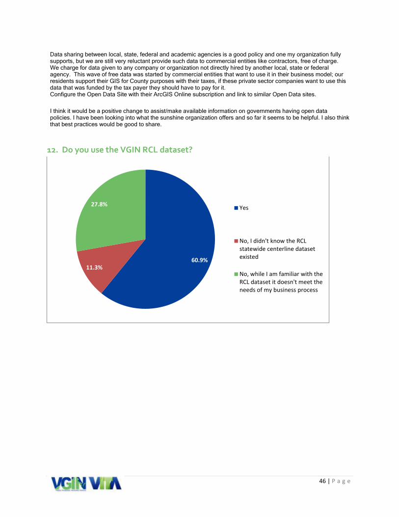
46 | P a g e
Data sharing between local, state, federal and academic agencies is a good policy and one my organization fully supports, but we are still very reluctant provide such data to commercial entities like contractors, free of charge. We charge for data given to any company or organization not directly hired by another local, state or federal agency. This wave of free data was started by commercial entities that want to use it in their business model; our residents support their GIS for County purposes with their taxes, if these private sector companies want to use this data that was funded by the tax payer they should have to pay for it. Configure the Open Data Site with their ArcGIS Online subscription and link to similar Open Data sites.
I think it would be a positive change to assist/make available information on governments having open data policies. I have been looking into what the sunshine organization offers and so far it seems to be helpful. I also think that best practices would be good to share.
12. Do you use the VGIN RCL dataset?
60.9% 11.3%
27.8% Yes
No, I didn't know the RCLstatewide centerline datasetexisted
No, while I am familiar with theRCL dataset it doesn't meet theneeds of my business process

47 | P a g e
13. Please indicate the extent to which you agree or disagree with the following statements as they relate to your use of the RCL (5 = highest, strongly agree):
Rank Statement Rating Average (5 being the highest)
1 VGIN should implement a feedback mechanism for quality control to inform organizations of changes being made to their data 4.26
2 VGIN should encourage bordering states to participate in the RCL to build a better dataset for supporting areas along the state border 4.04
3 The RCL is a consistent dataset that provides accurate routing for regional and statewide data 3.99
4 VGIN should analyze address data along jurisdictional boundaries to ensure the data is not being duplicated 3.97
5 Quarterly data updates provide an adequate dataset to effectively support public safety response 3.86
6 Dataset provides accurate continuity across political boundaries to effectively support public safety response 3.78
7 Issues with line segmentation, vector directionality, and addressing need before the dataset can be used to effectively support public safety response
3.74
14. From the reasons listed below, how does the RCL not meet the needs of your business process?
5.6%
38.9%
47.2%
16.7%
25.0%
0.0%
5.0%
10.0%
15.0%
20.0%
25.0%
30.0%
35.0%
40.0%
45.0%
50.0%
The site fordownloading
data is difficultto use
I have access toother datasets
are moreaccurate and up
to date
This is not adataset I use in
my businessworkflow
The data is not inthe format orschema that Ineed for my
tasks
Other

48 | P a g e
Other Comments: I deal primarily with State Park land only and don't have much need for the RCL data.
My office has one staff GISP who serves as our local expert and handles the day to day task. I generally only use regional data.
Our own centerline data is kept up to date. We contribute our data to the RCL. Our schema is set up to work with our other enterprise systems, especially it is used with our asset management system. We would be interested in VDOT Road classifications and traffic counts as we are sometimes asked for this information and have no easy way to provide it/ show it for our area in correlation with our data. I don't know how to use it. Need more training.
We have not yet adopted the RCL, but we are discussing doing so.
We have our own recently created and continuously updated RCL for our locality. Our maps are more accurate than what VDOT shows on their paper maps of Lee County.
The highway locations and segmenting differ from my local street centerline file that supports my CAD. Edgmatching does not match what local governments are using
15. Do you use the VBMP Orthophotography?
87.6%
4.7%
7.8%
Yes
No, I didn't know there was astatewide orthophotographydataset
No, while I am familiar with theVBMP program, it doesn't meetthe needs of my businessprocess
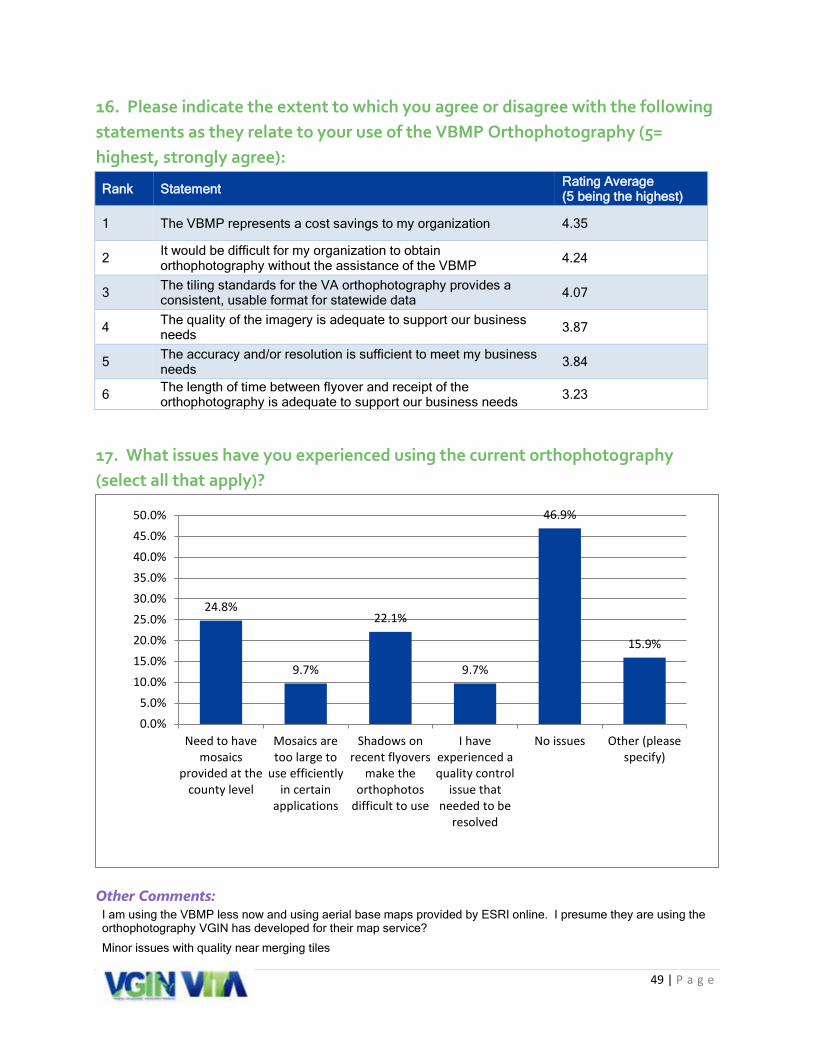
49 | P a g e
16. Please indicate the extent to which you agree or disagree with the following statements as they relate to your use of the VBMP Orthophotography (5= highest, strongly agree):
Rank Statement Rating Average (5 being the highest)
1 The VBMP represents a cost savings to my organization 4.35
2 It would be difficult for my organization to obtain orthophotography without the assistance of the VBMP 4.24
3 The tiling standards for the VA orthophotography provides a consistent, usable format for statewide data 4.07
4 The quality of the imagery is adequate to support our business needs 3.87
5 The accuracy and/or resolution is sufficient to meet my business needs 3.84
6 The length of time between flyover and receipt of the orthophotography is adequate to support our business needs 3.23
17. What issues have you experienced using the current orthophotography (select all that apply)?
Other Comments: I am using the VBMP less now and using aerial base maps provided by ESRI online. I presume they are using the orthophotography VGIN has developed for their map service?
Minor issues with quality near merging tiles
24.8%
9.7%
22.1%
9.7%
46.9%
15.9%
0.0%5.0%
10.0%15.0%20.0%25.0%30.0%35.0%40.0%45.0%50.0%
Need to havemosaics
provided at thecounty level
Mosaics aretoo large to
use efficientlyin certain
applications
Shadows onrecent flyovers
make theorthophotos
difficult to use
I haveexperienced aquality control
issue thatneeded to be
resolved
No issues Other (pleasespecify)
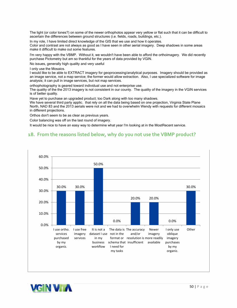
50 | P a g e
The light (or color tones?) on some of the newer orthophotos appear very yellow or flat such that it can be difficult to ascertain the differences between ground structures (i.e. fields, roads, buildings, etc.). In my role, I have limited direct knowledge of the GIS that we use and how it operates. Color and contrast are not always as good as I have seen in other aerial imagery. Deep shadows in some areas make it difficult to make out some features.
I'm very happy with the VBMP. Without it, we wouldn't have been able to afford the orthoimagery. We did recently purchase Pictometry but am so thankful for the years of data provided by VGIN. No issues, generally high quality and very useful I only use the Mosaics. I would like to be able to EXTRACT imagery for geoprocessing/analytical purposes. Imagery should be provided as an image service, not a map service; the former would allow extraction. Also, I use specialized software for image analysis; it can pull in image services, but not map services. orthophotography is geared toward individual use and not enterprise use. The quality of the the 2013 imagery is not consistent in our county. The quality of the imagery in the VGIN services is of better quality. Have yet to purchase an upgraded product; too Dark along with too many shadows. We have several third party applic. that rely on all the data being based on one projection, Virginia State Plane North, NAD 83 and the 2013 aerials were not and we had to overwhelm Wendy with requests for different mosaics in different projections. Orthos don't seem to be as clear as previous years. Color balancing was off on the last round of imagery. It would be nice to have an easy way to determine what year I'm looking at in the MostRecent service.
18. From the reasons listed below, why do you not use the VBMP product?
30.0% 30.0%
50.0%
0.0%
20.0% 20.0%
0.0%
30.0%
0.0%
10.0%
20.0%
30.0%
40.0%
50.0%
60.0%
I use ortho.services
purchasedby my
organiz.
I use freeimageryservices
It is not adataset I use
in mybusinessworkflow
The data isnot in theformat or
schema thatI need formy tasks
The accuracyand/or
resolution isinsufficient
Newerimagery
more readilyavailable
I only useobliqueimagery
purchasesby my
organiz.
Other

51 | P a g e
Comments: Our office has one GISP who werves as our local expert and handles those day to day task. I would probably use it if I had more information about it. Use oblique and ortho
19. The VBMP Orthophotography is one of the primary VGIN programs funded by the General Assembly. A new RFP will be released in 2016, which will allow VGIN to modify the components of the contract and the data that is available. Please rank this list of requirements that you would like to see included in future procurement cycles. If the requirement should not be considered, please check the “Does not apply” check box before ranking the rest (1=highest, 5=lowest)
Rating Requirements Rating Average (1 being the highest)
1 Compressed delivery schedule of products 2.2
2 Negotiate statewide Master Contract for oblique imagery to supplement VGIN provided ortho. 3.0
3 Negotiate statewide Master Contract for imagery (such as Google, satellite, other) to supplement VGIN ortho. 3.0
4 Increase quality control requirements 3.1
5 Lower minimum purchasing requirements for unscheduled flights 3.3

52 | P a g e
20. Have you used the compiled VGIN Administrative Boundaries dataset?
21. Please indicate the extent to which you agree or disagree with the following statements as they relate to your use of the VGIN Administrative Boundaries dataset (5= highest, strongly agree):
Rank Statement Rating Average (5 being the highest)
1 The VGIN Administrative Boundaries data set is a useful way to submit the requested updated boundaries to the US Census Bureau 3.96
2 The VGIN Admin. Boundaries dataset is a useful effort that provides a successful model for developing other standard statewide datasets 3.81
3 The format of the data is sufficient for my requirements 3.69
4 The VGIN Administrative Boundaries dataset provides the same level of accuracy and currency as local data 3.32
25.6%
24.8%
49.6%
Yes
No, I didn't know there was astatewide administrativeboundaries dataset
No, while I am aware of thedataset I have not used it in mybusiness process

53 | P a g e
22. Why do you not use the VGIN Administrative Boundaries product?
Other Comments:
You get your data from me. I just use my own
Useful data, however staff expert handles this task.
Our Corporate Limit is tied to many other features in our GIS. Making changes to what we use for our boundary it would be a very large project with a lot of planning and considerations.
Needs "historic" versions as boundaries change. Also need to address competing versions. It's still in draft, right? I'm still working with our neighbors to make our boundaries consistent.
We have not reviewed the dataset. Data does not agree spatially with other data layers being used.
54.8%
3.2%
11.3%
30.6%
4.8%
11.3%
0.0%
10.0%
20.0%
30.0%
40.0%
50.0%
60.0%
I have not hadtime to
evaluate thisdata yet
The interface todownload thisdata is difficult
to use
The data doesnot accurately
reflect the localversions of this
dataset
It is not adataset I use in
my businessworkflow
The data is notin the format or
schema that Ineed for my
tasks
Other

54 | P a g e
23. Do you or your organization/department support emergency communications with GIS data?
24. From the scenarios below, please select the one that best describes the GIS support to your emergency communications center.
66.4%
2.4%
31.2% Yes
No, but I work in an emergencycommunications center (PSAP)
No, my organization does notsupport an emergencycommunications workflow
16.5%
32.9%
37.6%
4.7% 8.2%
0.0%
5.0%
10.0%
15.0%
20.0%
25.0%
30.0%
35.0%
40.0%
Dedicated GISstaff
Part time GISstaff
Some GISsupport - when
needed
There is no GISsupport for the
emergencycommunications
center
I don't know

55 | P a g e
25. When do you see NG911 becoming a priority for your organization?
26. Please indicate the extent to which you agree or disagree with the following statements as they relate to NG911 (5= highest, strongly agree):
Rank Statement Rating Average (5 being the highest)
1 There is a need for guided support at the local level from the state in planning for GIS support of my NG911 solution 4.2
2 Funding is a major problem for updating GIS datasets to support NG911 3.8
3 There is currently sufficient interaction between GIS and Public Safety to support my NG911 solution 3.1
4 Standards and Best Practices are currently adequate to successfully implement NG911 2.7
10.6% 10.6% 11.8% 10.6%
21.2%
4.7%
30.6%
0.0%
5.0%
10.0%
15.0%
20.0%
25.0%
30.0%
35.0%
We have aNG911system
6 months 1 year 18 months 3 years 5 years I don'tknow or
longer than5 years

56 | P a g e
27. Provide additional comments on other VGIN Programs (VGIN website, other basemapping, elevation, broadband availability, landcover data, outreach and education, etc.) as needed. I think one of VGIN's goals should be addressing the inequality in GIS services throughout the state. Some counties have very little data while others are data rich. Some agencies are way out in front with this technology while others struggle to keep up due to lack of funding or decision-maker buy in. Can VGIN help poor agencies and jurisdictions go after grants or other resources? Can they provide "What GIS can do for you" training to agency heads? Can a VGIN employee rotate among state agencies to help with development needs? Would VGIN consider partnering with universities to develop an army of interns that can be deployed to collect data from localities that don't have staff or equipment resources? To encourage agencies to share data, provide servers that host data for ArcGIS online outside of the VITA system--or do not charge for these services through VITA. Regional governments need to play a stronger role in consolidating and QCing data from their localities for use by the state. They need some education on open source and a stronger motivation to work with the state.
Provide education with guidance to elected leaders to show why and whats the value of GIS, especially in NG 911. Leading our board members to water is one thing but they'd drown before they'd ever take a drink, yet it takes their buy-in to fund the positions needed to maintain the data sets.
Regularly updated landcover data is greatly needed, particularly with respect to local implementation of state programs.
While the State Photography meets 95% of the City's needs, the utilities express a need for tighter controls and higher accuracy. Thank you
GIS is a powerful tool and the data that supports the tool can be use a wide range of applications and conduct various anaylsis, yet there seems to be a break down at higher government levels on how much support is needed for effective use as well as support staff. GIS should be major elements of most DOT work.
Please keep working hard to support development of statewide LiDAR data.
Thank you for your efforts! The addition of the administrative boundary data is very useful. However, I would like to see it updated more frequently (perhaps quarterly) by ALL counties in Virginia. The VBMP program is extremely important for localities in VA. Having more options added to that program would be helpful. Such as Statewide Lidar (and the education of its use), Oblique imagery options for flyover years or for off years, other imagery options for off years, landcover data and impervious surface data. Outreach and education on ROI for GIS to assist us in defending our programs and purchasing VBMP offerings. Education / data / justification we can turn to when asked "why cant we just use google maps?". A statewide contract for ESRI training to make it more affordable, Statewide contracts for items like Community Analyst offered by ESRI that contain useful demographics and business data for analysis. Facilitation of more collaboration efforts with neighboring localities to make VBMP upgrades more affordable (with more options for lower prices for a larger areas, not just on Ortho upgrades). NG911 - Education for the GIS community on the standards our data will need to "meet". Thanks!
More information on NG911 GIS Data standards.
Provide for more periodic press releases across VA about the value and opportunities by having VGIN data available and how to contact local managers at county levels to obtain assistance in using it.
Statewide AGSOnline presence/capability
Website needs a link to Data Clearinghouse or some explanation as to how to get there. Website needs to be more user-friendly in general.
Our biggest challenge is training and assistance with specific technical tasks. My biggest hope for VGIN is to act as a resource small governments and agencies can go to for technical assistance for specific GIS tasks. Currently; out biggest grey area is in how to get our data on the web, without having to hire a contractor to run a website; simply publishing simple services and application through our AGS. The GIS side stuff isn’t the problem, but the interaction with the world wide web is.

57 | P a g e
Is there a way to increase the limit on the number of shapefile features that can be displayed on a web map? The limit currently stands at 1,000 features. This limits the ability to display certain kinds of Census Data. For example, the number of Census Tracts statewide is 1,907, and the number of Census Block Groups is 5,332. By not being able to display these features, we are handicapping the state's ability to share valuable information, especially from a demographic thematic mapping perspective.
More free stuff with the VBMP! ;>)
elevation models should be included with ortho products
I would love to have multi-return LiDAR data for the whole state!
2013 Lidar of Tidwater area was great. Only would add that the contractor also provide contours as product too. That way I don't make them one way and someone else makes them another way for the same areas. Trade or switch out aerial photography for lidar collection would be nice for folks that contract aerial photography fly-overs more frequently than the State. I have not looked at the Strategic Plan, but do not see any mention of technology support for state agencies in this survey. Most of our needs (in my opinion) are in the area of how to implement lightweight mapping/data visualization solutions for state programs (e.g., ArcGIS for Organizations). This is an area I have asked VGIN about for years and gotten relatively little useable feedback or support. How do I connect an internal "database" to web mapping and make it available across my program/enterprise? Has VGIN ever considered acquiring the technology/staff necessary to capture aerial imagery or is it entirely too cost prohibitive?
Please redesign the website. It is very difficult to navigate and find information.
Yes, the VGIN/VITA website still needs to have a major layout change so that it is easier to navigate. Broadband maps need to be updated with recent installations. IT education for GIS personnel. e.g. networking, server mgmt, preparing GIS data to be used in Map Services.
FEMA's National Flood Insurance Program should be provided with VGIN Administrative Boundary changes when they become effective. LiDAR is necessary state wide.

58 | P a g e
Appendix E: Public Comments on Strategic Plan
Comments will be included here after the public comment period ends in January 2015.