gis-mo - wa
TRANSCRIPT


THESIS
1. Why Are We Doing This2. Increasing Mobility3. VUEWorks4. Increasing Interoperability5. Implementation Time Line

CRAB MISSIONThe mission of the Washington State County Road Administration Board (CRAB) is to preserve and enhance the transportation infrastructure of Washington Counties by providing standards of good practice, fair administration of funding programs, visionary leadership, and integrated, progressive, and professional technical services.
RCW 36.78.070 (4) Advise counties on issues relating to county roads and the safe and efficient movement of people and goods over county roads and assist counties in developing uniform and efficient transportation-related information technology resources;

MAP-21MAP-21 included requirements for the collection of roadway data based on the Model Inventory of Roadway Elements (MIRE)and the use of a linear referencing system (LRS). Subset of MIRE established as part of the HSIP Final Rule changes to 23 CFR Part 924. The FDEs are a recommended set of 37 roadway and traffic elements that include roadway segment, intersection, and ramp/ interchange data that are needed to conduct enhanced safety analysesMIREThe law required the Secretary of the U.S.Department of Transportation (DOT) to establish a subset of MIRE that is useful for the inventory of roadway safety and to ensure that States adopt and use the subset to improve data collection [23 U.S.C. 148(f)(2)]. FHWA established a subset of MIRE as part of the Highway Safety Improvement Program (HSIP) Final Rule changes to 23 CFR Part 924,effective April 14, 2016.To meet HSIP U.S. 23 CFR 924, which notes that a state DOT should have access to a complete collection of roadway and traffic data for all public roads by September 2026,

Asset ManagementDefinition from the International Infrastructure Manual (IIMM)
The combination of management, financial, economic, engineering and other practices applied to physical assets with the objective of providing the required level of service in the most cost-effective manner
CRAB’s Goals
Establish and maintain a uniform system of bridge and roadway maintenance categories, and associated costs.

ASSESSMENT
What do I own?
Where is it?
What condition is in and what is the performance?
What is the remaining useful life?
What is its remaining economic value?

Work Management
• Service Request• Work Order• Resource Management
Strategic Asset Management
• Condition• Risk Analysis• Budget Analysis
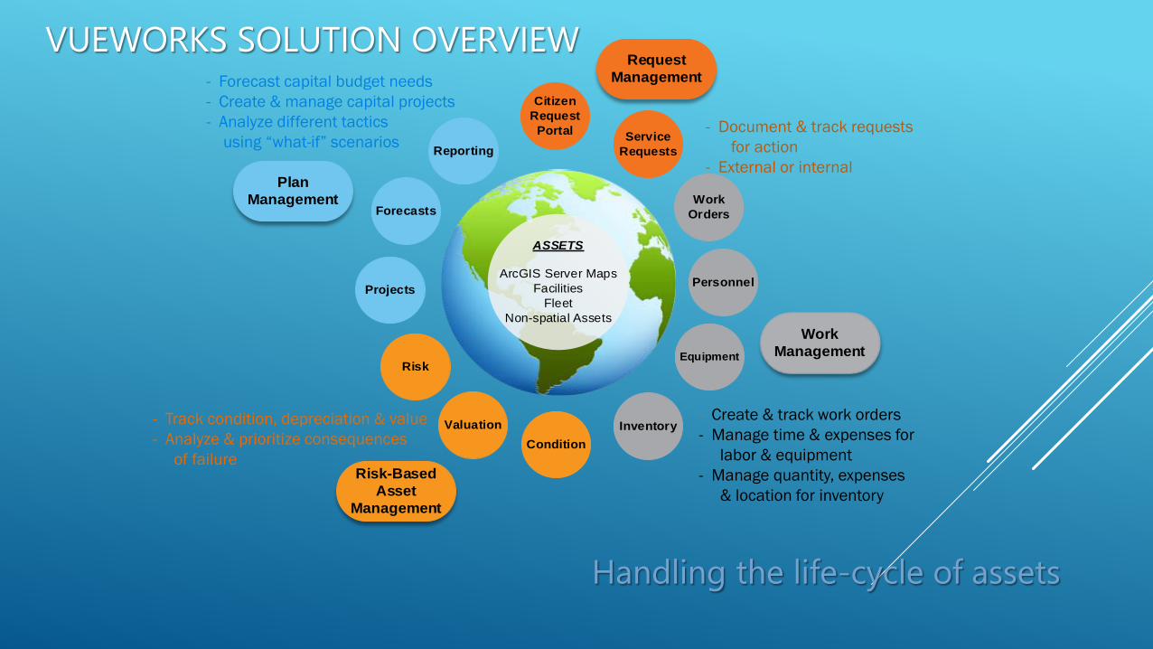
- Track condition, depreciation & value- Analyze & prioritize consequences
of failure
- Forecast capital budget needs- Create & manage capital projects- Analyze different tactics
using “what-if” scenarios- Document & track requests
for action- External or internal
- Create & track work orders- Manage time & expenses for
labor & equipment- Manage quantity, expenses
& location for inventory
ASSETS
ArcGIS Server MapsFacilities
FleetNon-spatial Assets
Citizen Request
Portal Service Requests
Work Orders
Personnel
Equipment
InventoryCondition
Risk
Valuation
Projects
Forecasts
Reporting
Handling the life-cycle of assets
Plan Management
Work Management
Risk-Based Asset
Management
Request Management
VUEWORKS SOLUTION OVERVIEW

Strategic Asset Management• Track condition, depreciation & value• Prioritize consequences of failure• Forecast capital budget needs• Create & manage capital projects
Work Management• Document & track citizen issues• Create & track work orders• Manage time & expenses for labor & equipment• Manage quantity & expenses for inventory
Map & Data Sharing• Web browser based • View maps and data• Manage users• Search & report
• Display & manage layers• List and edit attributes• Link documents & data• Manage facilities
VUEWORKS SOLUTION OVERVIEW

COUNTY ROAD ASSETS
40k miles of county roads
120k culverts
3400 bridges >= 20 feet
2000 miles of guardrail
300k Sign Posts
Street Lights, Traffic Signals, Storm Systems, Curb Ramps, etc.
Construction Expenditure26%
Maintenance Expenditure
41%
Admin. & Oper. Expenditure
18%
Other Expenditure
15%
2015 County Road Revenue - $911,589,992
asset quantities are estimates only!
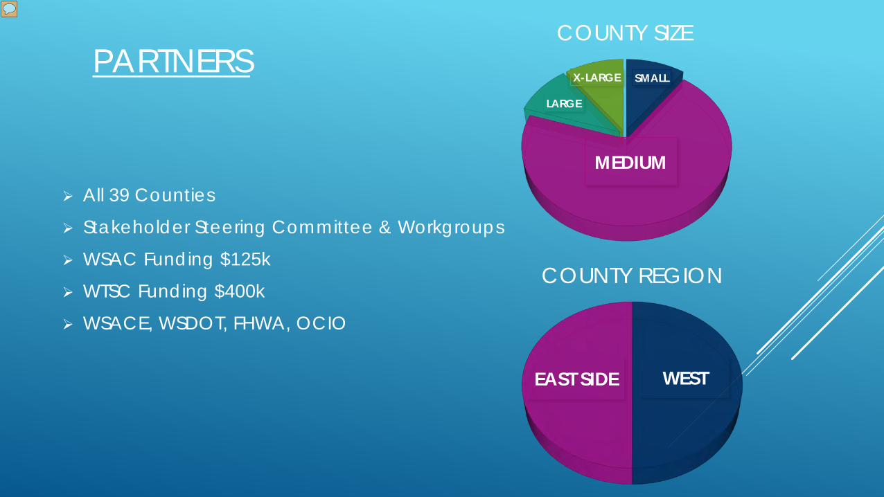
All 39 Counties
Stakeholder Steering Committee & Workgroups
WSAC Funding $125k
WTSC Funding $400k
WSACE, WSDOT, FHWA, OCIO
PARTNERSSMALL
MEDIUM
LARGE
X-LARGE
COUNTY SIZE
WEST EAST SIDE
COUNTY REGION
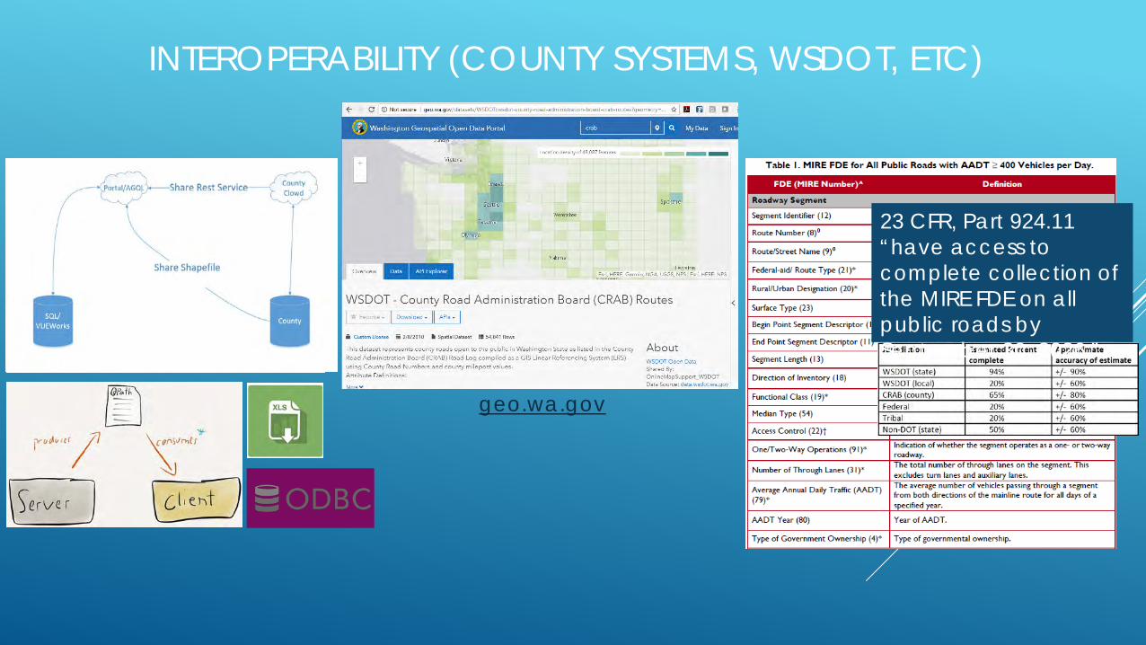
INTEROPERABILITY (COUNTY SYSTEMS, WSDOT, ETC)
23 CFR, Part 924.11 “have access to complete collection of the MIRE FDE on all public roads by September 30, 2026.”
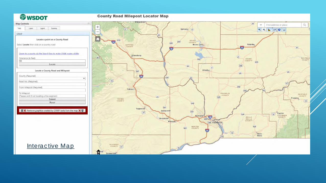
geo.wa.gov


WHO HERE USES ESRI MAPPING?
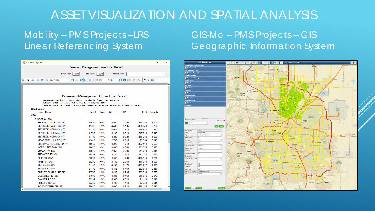
ASSET VISUALIZATION AND SPATIAL ANALYSISMobility – PMS Projects –LRSLinear Referencing System
GIS-Mo – PMS Projects – GISGeographic Information System

PAVEMENT DISTRESS IMAGEUsing PSC data and
Developing maps

MOBILE DATA COLLECTION (MAINTENANCE & CONDITION)

TIMELINE
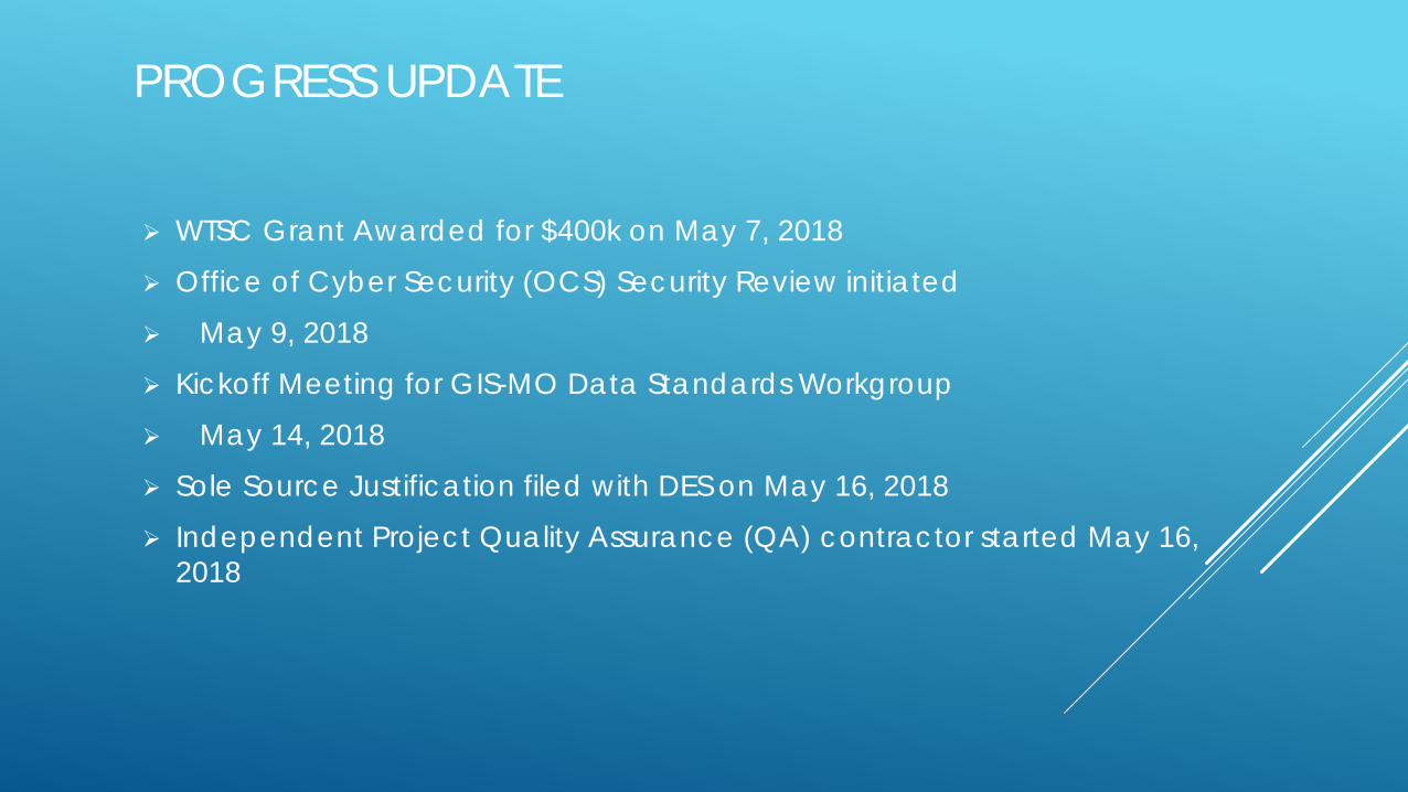
PROGRESS UPDATE
WTSC Grant Awarded for $400k on May 7, 2018
Office of Cyber Security (OCS) Security Review initiated
May 9, 2018
Kickoff Meeting for GIS-MO Data Standards Workgroup
May 14, 2018
Sole Source Justification filed with DES on May 16, 2018
Independent Project Quality Assurance (QA) contractor started May 16, 2018

COMING SOON
Contract Signed
Database Development
County Integration
County Training

QUESTIONS FOR TREATS
Q: What does Esri acronym stand for?
A: ___________________________________
Q: What does GIS stand for?
A: ___________________________________
Q What does Lidar Stand for?
A: ___________________________________
Q: What is the Most Important Road Asset?
A: ___________________________________

QUESTIONS?